Aldo Leopold, Colorado River delta, Baja California, Mexico Credit: Courtesy Aldo Leopold Foundation and the University of Wisconsin-Madison Archives
Click the link to read the article on the AZCentral.com website (Brandon Loomis). Here’s an excerpt:
December 15, 2025
Key Points
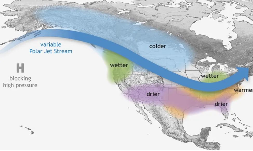
Seven states and 30 tribes that depend on the Colorado River are looking for ways to share a shrinking resource, but environmental groups fear little will be left for the river itself.
A wetlands at the end of the river and a fishery at its midpoint show what can happen when water is managed to preserve nature’s needs.
Growing demand on the river and competing interests, including electric power providers, could force negotiators for the states to confront difficult decisions.
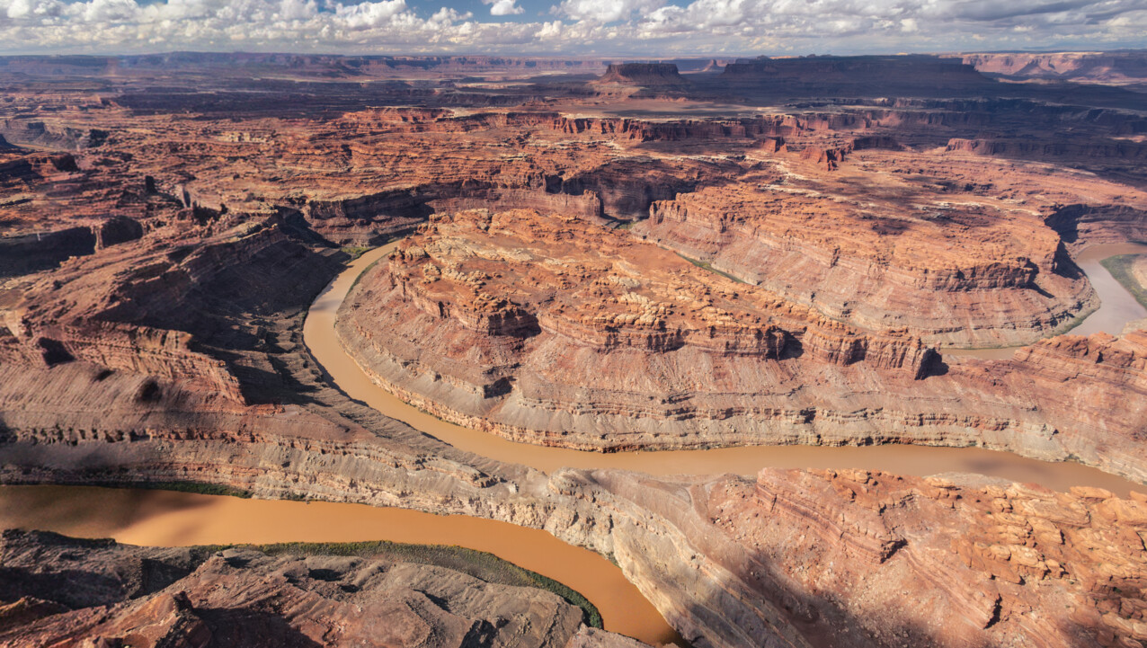
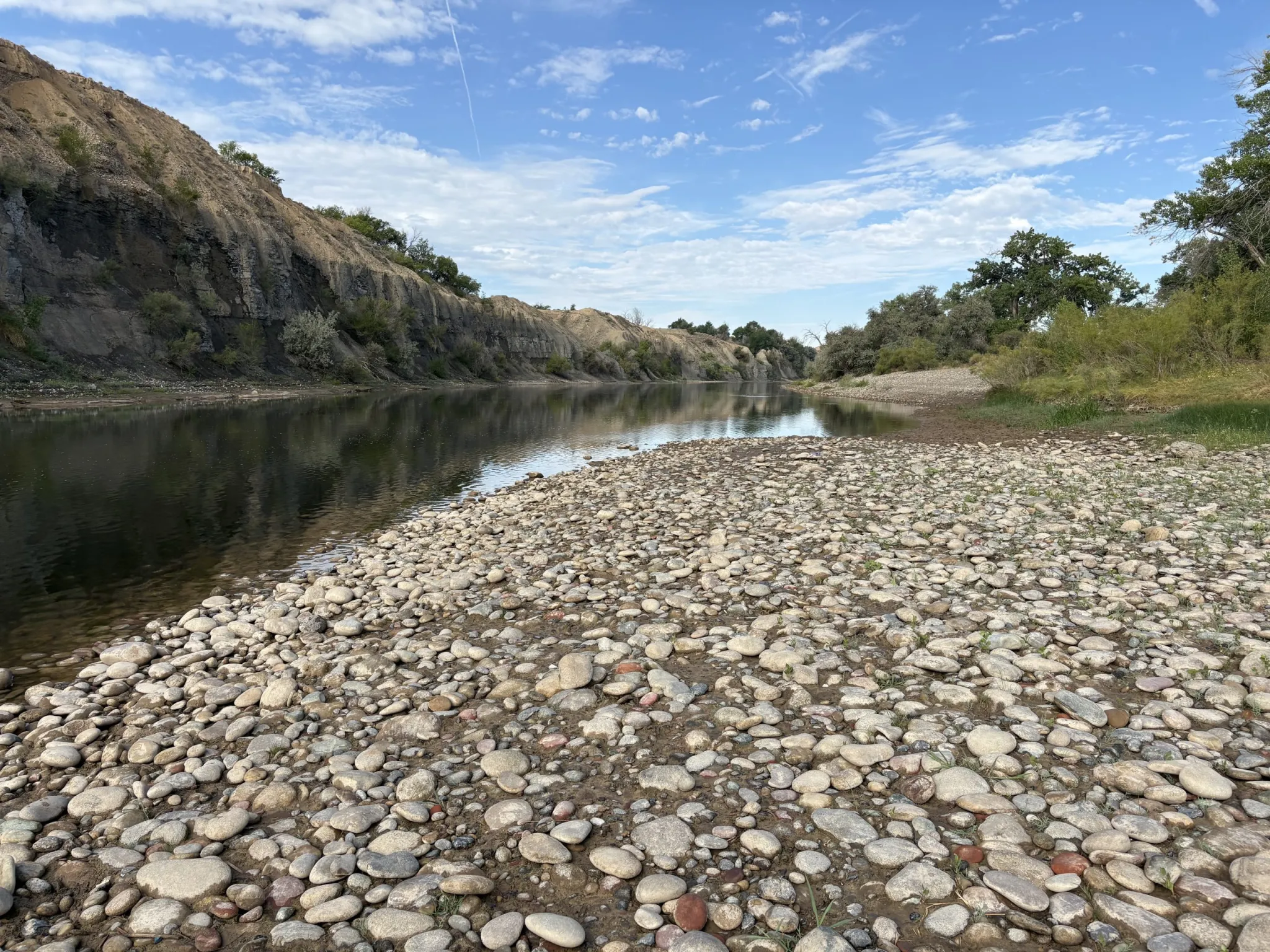
CIÉNEGA DE SANTA CLARA, Mexico — The rusty observation tower at the edge of this wastewater-fed marsh offers an osprey-eye view of two possible futures for the parched and overworked Colorado River. To one side, the marsh spreads across more than 20 square miles of pools and islands choked with cattails and phragmites, convoys of pelicans descending and splashing down for a rest on their journey south from the Great Salt Lake or other western waters. Dragonflies hover below, while a fish hawk circles above, scanning the open water between the reeds. This is a vision of a future in which partners across the Western United States and Mexico save enough water that they can spare some for nature, even if it means irrigating it with the salty dregs. On the tower’s other side, boundless flats of sand and cracked mud spread to the horizon across what was, prior to the river’s damming a century ago, one of Earth’s great green estuaries.
Colorado River Dry Delta, terminus of the Colorado River in the Sonoran Desert of Baja California and Sonora, Mexico, ending about 5 miles north of the Sea of Cortez (Gulf of California). Date: 12 January 2009. Source http://gallery.usgs.gov/photos/10_15_2010_rvm8Pdc55J_10_15_2010_0#.Ur0mcvfTnrd. Photographer: Pete McBride, U.S. Geological Survey
Jennifer Pitt leaned against a rail atop the tower and scanned that dusty horizon. A century ago, she said, the river had meandered so widely and soaked so much verdant ground there that the naturalist Aldo Leopold had written in “A Sand County Almanac” that “the river was nowhere and everywhere,” unable to “decide which of a hundred green lagoons offered the most pleasant and least speedy path to the Gulf (of California).”
Now the Grand River’s delta supports just a handful of green lagoons, all fed either by wastewater or by targeted environmental irrigation. Pitt leads the Audubon Society’s Colorado River program. She has toiled for decades alongside American and Mexican conservationists to rebuild slivers of living delta from what’s left of the water after dams, farm ditches and growing cities divert most of the great river along its 1,450-mile route from the Rocky Mountains toward its dry mouth on the Sea of Cortez near here. A century ago, the river would have wandered a soaked delta teeming with birds, jaguars and legendary biodiversity. Now, a wastewater marsh must do the ecological heavy lifting.
Jennifer Pitt and Brad Udall at the Getches-Wilkinson Center/Water and Tribes Initiative conference June 5, 2025. Photo credit: Allen Best/Big Pivots
“If we can’t prioritize taking care of a place like this, I fear for our ability to take care of ourselves,” Pitt said.
Udall/Overpeck 4-panel Figure Colorado River temperature/precipitation/natural flows with trend. Lake Mead and Lake Powell storage. Updated through Water Year 2025. Note the tiny points on the annual data so that you can flyspeck the individual years. Credit: Brad Udall
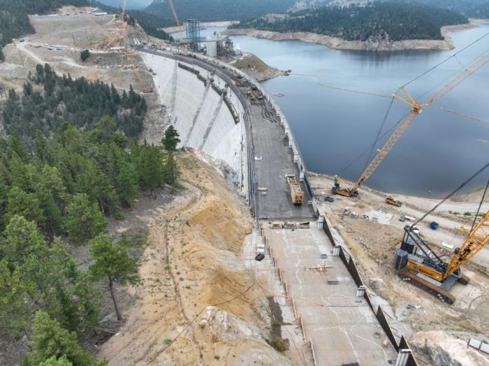
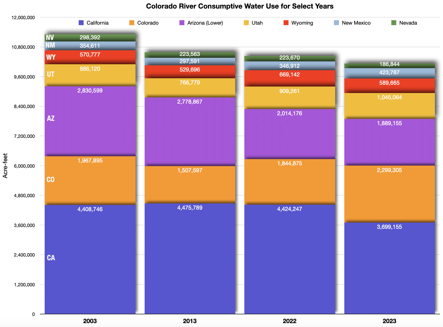
The next few months will be a turning point in efforts to preserve a measure of nature here and across the river’s length, as the seven U.S. states that split the bulk of the water struggle to reach a new deal among themselves that could also determine how much water is available to nurse a remnant of the river’s own environment. Federal officials have said Interior Secretary Doug Burgum is prepared to impose his own cuts if the states can’t reach their own deal, and have said they need a negotiated plan by late winter to avoid that outcome. More than two decades of “megadrought,” unprecedented in U.S. history, have left little wiggle room for year-to-year operations. Reservoirs that were near their 58.48 million-acre-foot capacity in 2000 began the 2026 water year on Oct. 1, with just 21.8 million acre-feet behind the dams. Each acre-foot contains about 326,000 gallons and is roughly enough to support three households for a year, though the bulk of the water flows to the region’s farms.
Jennifer Pitt, the National Audubon Society’s Colorado River program director, paddles a kayak through a restoration site. (Source: Jesus Salazar, Raise the River)
Click the link to read the article on the Big Pivots website (Allen Best):
December 12, 2025
New ‘book’ explores the evolving thoughts about an increasingly dire situation
To put that into perspective, the Colorado River Compact assumed an average 16.5 million acre-feet at that site, Lees Ferry. The river this century has produced far less. Since 2020, the river flows have declined even more, to an average of 10.8.
September 21, 1923, 9:00 a.m. — Colorado River at Lees Ferry. From right bank on line with Klohr’s house and gage house. Old “Dugway” or inclined gage shows to left of gage house. Gage height 11.05′, discharge 27,000 cfs. Lens 16, time =1/25, camera supported. Photo by G.C. Stevens of the USGS. Source: 1921-1937 Surface Water Records File, Colorado R. @ Lees Ferry, Laguna Niguel Federal Records Center, Accession No. 57-78-0006, Box 2 of 2 , Location No. MB053635.
Might it get worse?
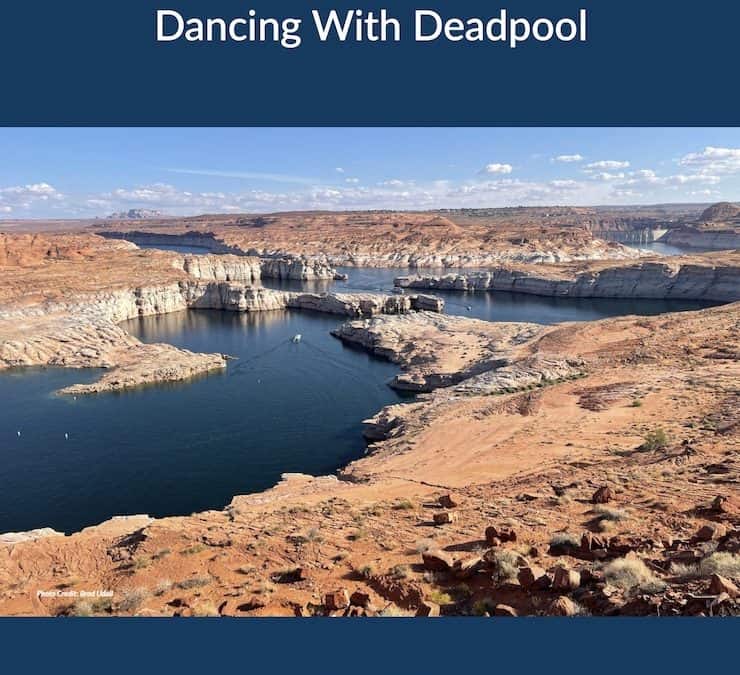
“Dancing With Deadpool,” a new product from the Colorado River Research Group, delivers the short answer.
“Another year or two of low inflows and we will completely blow through the cushions provided by reservoir storage,” says the document’s executive summary. The word “crisis” litters the 64-page production. It has eight chapters written by 22 authors from Colorado and three other Colorado River Basin states.
The Colorado River has fascinated journalists since at least the 1980s. Then, the river was still delivering water to Mexico’s Sea of Cortez but troubles were evident on the horizon. The river now, except for specially engineered releases from upstream dams, disappears entirely after crossing into Mexico.
Since 2022, the Colorado River had become a national story. Empty seats at the annual Colorado River Water Users Association conference in Las Vegas have disappeared, press credentials harder to secure.
The tension even in the last year has grown. The river runoff this year was only 55% of long-term average. The seven basin states remain at an impasse about solutions proportionate to the problem.
“We have now entered a new era: Dancing with Deadpool,” says the report.
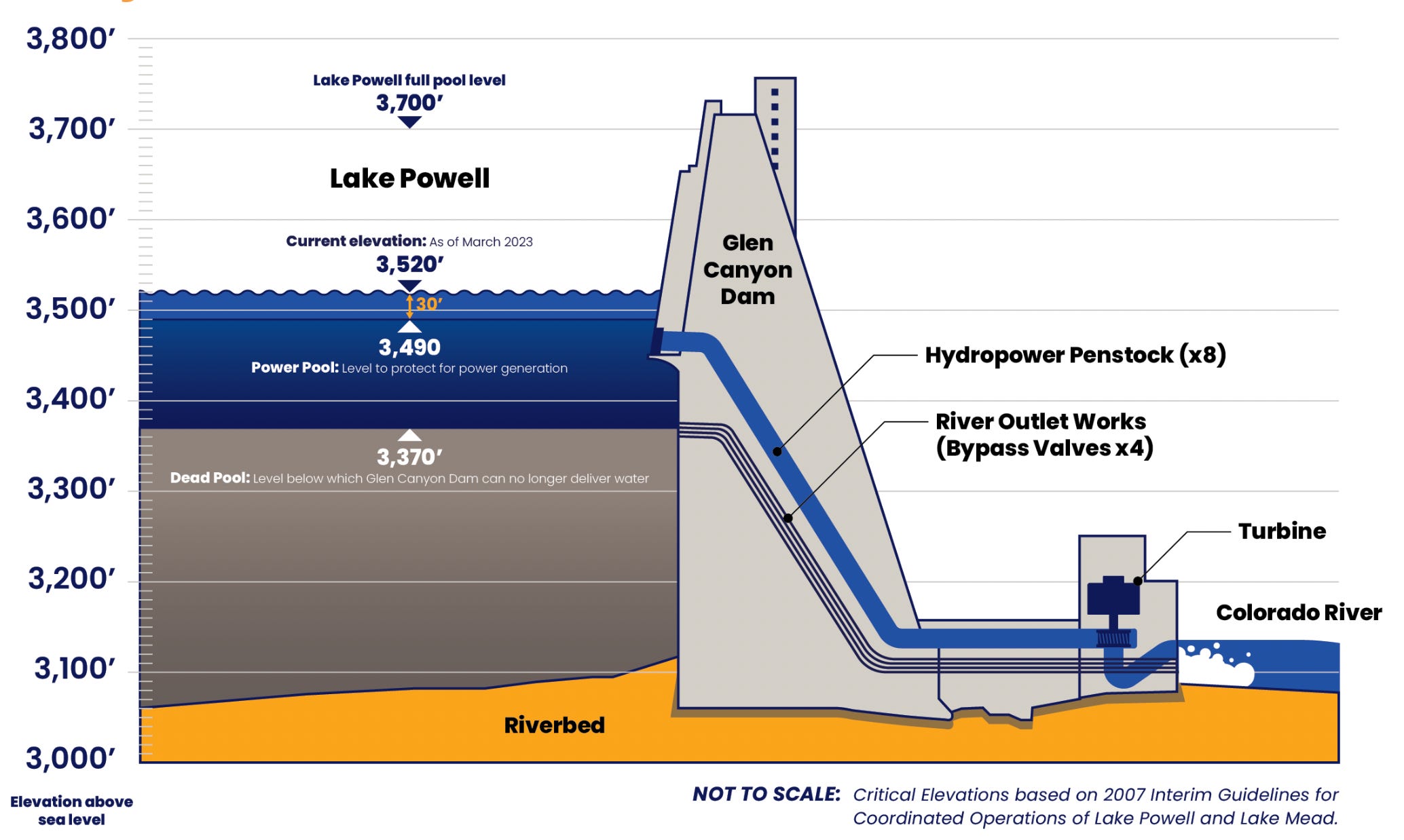
Deadpool is the point at which reservoirs can release no water. In 2022, that moment seemed imminent as sandstone walls of Glen Canyon were exposed directly to sunlight after being submerged since shortly after Lake Powell began filling. Then a miracle winter arrived, water levels in the two big reservoirs, Powell and Mead, rose once again, the emergency receded.
Now the crisis is back — and looming larger.
You can scare yourself to death with what-ifs, but we may need something akin to a miracle to avoid full-blown crisis. We cannot have another winter and then runoff like 2002-2003. Or, as several authors point out, runoff like we had in 2025.
As it is, we need another miracle winter, something akin to what diehard Denver Broncos fans remember as “the drive” in a 1987 playoff game. John Elway led his football team 98 yards down the field in Cleveland to tie the game with 37 seconds left. They won in OT.
Brad Udall and Jonathan Overpeck warn against too much optimism. Mother Nature can be stingy. She has been in the past, with one drought period as long as 80 years during the last 2,000 years. Now, the evidence grows that our monkeying with Mother Nature has produced this drought.
Udall/Overpeck 4-panel Figure Colorado River temperature/precipitation/natural flows with trend. Lake Mead and Lake Powell storage. Updated through Water Year 2025. Note the tiny points on the annual data so that you can flyspeck the individual years. Credit: Brad Udall
In 2017, Udall and Overpeck issued the results of their study that showed that warming alone was responsible for roughly half of the reduced natural flows of the Colorado River, at that point 17%. They delivered a new phrase: “hot drought” as distinguished from “dry drought.” The warmer temperatures were robbing the Colorado River Basin of water.
Precipitation in the basin has also declined 7% in the 21st century, as compared to the 20th century. In their chapter, Udall from Colorado State and Overpeck now at the University of Michigan (but with a summer cabin in San Miguel County), cite two new studies that together provide evidence “suggesting” complicity of humans. Greenhouse gases explain the declined precipitation, too.
As science is never 100%, Udall and Overpeck use cautious language. The studies, they say, “strongly suggest we are in for extended dry periods in the Colorado headwaters in the decades ahead.”
If there is less water, then isn’t the solution simple? Use less!
Easy to say. And for the last 20 years, efforts have been made to nibble away at uses. Cities have been working to make less water-intensive urban landscapes popular. But the far larger story lies in agriculture.
In Colorado and the three upper basin states, for example, about 70% of all the Colorado River water (after trans-basin diversions for irrigation are accounted for) goes to agriculture. How can ag use less water?
Two of the chapters work on this. A trio of academics from Wyoming and one from Colorado take aim specifically at the upper basin states. “The relevant questions are not whether or when cuts will happen, but how deep will they go, how will they be distributed, and how well can the consequences be mitigated?” they ask.
The four upper-basin researchers argue that evidence already exists for success. With creativity and collaboration, they say, farmers and ranchers can sustain crop and livestock production even as water becomes scarce. They get into the details, talking about adjustments of cow-calf operation, for example, to reduce water-dependent needs. They call for more research into limited irrigation, crop switching and other practices.
Two other academics, both from Arizona State, take a somewhat broader view, acknowledging the challenge.
“In a landscape of poor choices, in a failing river system in which all solutions are deeply unpopular to some or other powerful constituency, potentially harmful to one community or another or inordinately expensive and founded on unreliable funding, it is at least worth considering another option,” write Kathryn Sorensen and Sarah Porter.
They see cuts of up to 4 million acre-feet in the basin annually being necessary. Again, that’s about 25% of what those who created the Colorado River Compact expected would be annual flows for the seven basin states.
How to get there? They introduce a new concept, “economic water productivity,” a measure of the value of water. Instead of buy and dry programs, they see need for a federally financed effort to pivot uses through incentives to reduce water use on those agricultural lands.
Similar buy-down of high-volume irrigated agriculture is underway in two groundwater depletion areas in Colorado, the San Luis Valley and the Republican River Basin. Some federal money is providing help in the latter basin. They contend federal money will be needed, and lots of it, to pay for this big pivot in the Colorado River Basin. That, they say, would be fitting, because it was federal money that financed the infrastructure for this hydraulic empire.
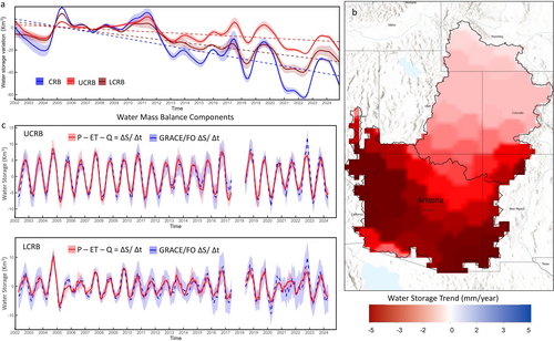
GRACE TWS trend map. (a) The time series of nonseasonal GRACE/FO TWS (km3/year) over UCRB and LCRB for the period (4/2002–10/2024). (b) Spatial variation in TWS trends for the Colorado River Basin for the investigated period (mm/year) (c) Time series comparison of the change in storage ΔS/Δt derived from the water balance equation (Equation 1) and GRACE/FO. ΔS/Δt calculated from GRACE/FO TWS anomalies in km3. The light shading represents uncertainties.
As for groundwater, that part of the Colorado River story has been generally overlooked. A study released several months ago found that nearly two-thirds of storage — both surface and groundwater — lost from 2002 to 2024 in the Colorado River actually came from groundwater depletion, mostly in Arizona.
Whoa!
“Simply shifting unsustainable surface water uses to unsustainable groundwater uses does nothing to address the core mismatch of supplies and demands,” observes Doug Kenney, who directs the Western Water Policy Program at University of Colorado Law School.
Other contributors dissect the complexities of what would seem to be simple, common sense solutions. For example, Eric Kuhn, the former general manager of the Colorado River District, works through the concept of water sharing among the states based on a percentage basis. The Colorado River Compact divides water between the upper and lower basins, a mistake in retrospect although even in 1922, when it was adopted, there had been an argument for using a percentage.
Later, when the upper-basin sates adopted a compact among themselves, they did use a percentage basis.
Kuhn goes deep into the history, as he has done with book-writing (“Science be Dammed,” 2019, with John Fleck) to sort through the thinking of this idea over the last century. It came up again earlier this year as the seven basin states tried to figure out how to share the river given the changed realities. The states, however, could not agree on what percentages should be used for sharing. It may have been just too much of a transformational change for some states to accept, he says.
However, the idea may come back if the stalemate between the upper and lower basins of the Colorado River ends up in the federal courts. Or failing that, what exactly would federal intervention look like? That’s an impolite question, but one of those what-ifs that must be wondered about. (For the record, the water people I know seem to have high regard for people in the Department of Interior in charge of looking after the Colorado River).
The large story here is that the states, with enormous aid from the federal treasury, created the infrastructure and expectations of water that no longer exists and, as per the studies of scientists, will almost certainly not return within the lifetimes of any of us. What, then, should be the federal role in defining the future balance? Once again, might the dismantling of Glen Canyon Dam be such a wild idea after all?
Thoughts in this book will likely be part of the conversations next week in Las Vegas when representatives of the seven basin states gather, as they always do, at the Colorado River Water Uses Association conference. Might a hallway conversation lead to a breakthrough?
Like huge snowstorms in the Rockies and then cool temperatures during runoff, there might be miracles, but I wouldn’t count on it. This deadpool dance might end sooner than anybody actually likes.
Map of the Colorado River drainage basin, created using USGS data. By Shannon1 Creative Commons Attribution-Share Alike 4.0
Graphic credit: Colorado River Research Group from the report “Dancing with Deadpool”
Click the link to access the report Dancing with Deadpool on the Getches-Wilkinson Center website (Doug Kenney1):
The rapid loss of storage in Lakes Mead and Powell is certainly deserving of the attention and angst it has generated and continues to generate, but it is the tip of larger trends altering the landscape of risk in the basin. The dismantling of many other “safety nets,” defined broadly, is happening at a pace far surpassing the already unprecedented declines in reservoir storage. Presumably that’s not an immediate problem if new post-2026 rules are able to recover and protect storage in Mead and Powell (and some of the other upstream facilities), but does anyone have that much faith in the power of new reservoir operating rules to combat the forces that have brought us to this point? What about when we have a 10 million acre-feet/year river?
GRACE TWS trend map. (a) The time series of nonseasonal GRACE/FO TWS (km3/year) over UCRB and LCRB for the period (4/2002–10/2024). (b) Spatial variation in TWS trends for the Colorado River Basin for the investigated period (mm/year) (c) Time series comparison of the change in storage ΔS/Δt derived from the water balance equation (Equation 1) and GRACE/FO. ΔS/Δt calculated from GRACE/FO TWS anomalies in km3. The light shading represents uncertainties.
From Groundwater to Governance
Perhaps the most obvious of those other diminishing safety nets is groundwater. Data on groundwater reserves throughout the basin is spotty at best. One approximation of a truly regional assessment comes from a creative use of satellite-based tools—namely NASA’s GRACE (Gravity Recovery and Climate Experiment) system that can detect tiny changes in gravitational forces associated with the fluctuating mass of aquifers losing (or gaining) storage. Those findings paint a truly disturbing picture. Despite the familiar (and troubling) images of bathtub rings emerging at Mead and Powell, researchers using GRACE data now estimate that, from 2002 to 2024, nearly two-thirds of storage—both surface and groundwater—lost in the Colorado River Basin actually came from groundwater depletions.2 Significant groundwater losses have occurred throughout the basin, but the problem is particularly acute in Arizona and is likely to accelerate as shortages in Central Arizona Project (CAP) deliveries are likely offset by groundwater pumping—an ironic outcome given that CAP was originally proposed as the solution to groundwater mining in the region. Simply shifting unsustainable surface water uses to unsustainable groundwater uses does nothing to address the core mismatch of supplies and demands.
A very different and multi-faceted trend undercutting the regional safety nets is happening within the federal government, where federal agencies, programs and science programs are being systematically dismantled under the guise of “efficiency.” It’s hard to understate the significance of these actions, as it is the federal government that, presumably, has the scope, mandate and resources to oversee the entirety of the River and the full diversity of its roles and values. Interior Department agencies in 2025, like much of the overall federal bureaucracy, have been tasked to achieve significant staffing reductions, and to eliminate (or significantly scale back) spending on key water conservation programs—including programs under the Inflation Reduction Act (IRA) and WaterSMART.3
Additionally, agencies across the federal landscape have mobilized to coerce and shut down climate-related science and scientists, despite the nearly universal acknowledgment among water managers of the central role of climate change in the unfolding crisis.4 Collectively these efforts constitute a systematic effort to discredit and hide the primary cause of the broken water budget, while sabotaging the most effective coping mechanisms available. As members of the research community, the Colorado River Research Group (CRRG)unfortunately has a front-row seat to this culling of the people and programs essential to long-term data collection and analysis. It defies logic, and is dangerous.
Unfortunately, hostility toward the people and programs essential to responding to the Colorado River crisis is not the full extent of federal obstruction. One largely unappreciated threat to the water budget resulting from federal policy shifts comes from efforts to “re-carbonize” (and accelerate) water-intensive energy generation, in part to meet the demands of AI, a particularly troubling trend given that the previous emphasis on renewable energy generation and enhanced energy conservation was one of the few positive trends working to repair the regional water budget.5 Attempts to weaken or dismantle bedrock environmental laws, such as NEPA and the Endangered Species Act, are an additional wildcard likely to inflict irreparable harm on already strained species and ecosystems.6
Given the turmoil at the federal level, it’s tempting to absolve the States for stubbornly clinging to a policy making system reliant on 7-state dealmaking, but that would ignore the reality that the governance of the river has been a problem for decades. A seemingly never-ending series of crisis-inspired negotiations, held in largely secretive forums without direct tribal involvement or tools for meaningful public or scientific engagement, is an uninspired way to manage and protect the economic, cultural and environmental heart of the American Southwest. The river is too big and too important to govern in such an ad hoc and primitive manner. [ed. emphasis mine]
That this approach mostly ”worked” to keep deliveries flowing for so long—except, of course, for the tribes and the environment—rested, in part, on the accepted norm that decisions would emerge collaboratively from the States and would not spill over to the federal courts. But even that governance safety net is eroding, as the States seem to be increasingly resigned—and almost “comfortable”—with the notion that the resolution of existing conflicts may not emerge from a negotiated 7-state agreement. For those parties and viewpoints that have historically been left out of the state-dominated processes and the resulting agreements, then maybe this prospect is welcome. But all would concede that would be a stunning outcome with ramifications that are difficult to predict.
Ever since the Arizona v. California experience, the use of litigation to resolve interstate (and/or interbasin) conflicts in the basin has been a third rail issue, and for very good reasons. As shown by the basin’s earlier foray into Supreme Court action, the process would undoubtedly be lengthy, expensive, and likely to create as many issues and questions as it resolves. It certainly wouldn’t reduce risk, as the states, and the water management community more broadly, would lose control over the process of managing the shared resource. In fact, judicial intervention might be the impetus to trigger yet another traditionally feared decision pathway to be invoked—a Congressional rewrite of river allocation and management—either before or after the litigation concludes. In this setting, the extreme disparity in political influence—as measured by the number of Congressional representatives—between the Upper and Lower Basin is an obvious concern, as is the realization that congressional involvement means the future of the Colorado now becomes a national issue and, potentially, a bargaining chip to be used in the political logrolling necessary to enact legislation in dozens of otherwise unrelated areas.
Screenshot from Kestrel Kunz’s presentation at the CRWUA 2023 Annual Conference.
Rowing in the Wrong Direction
Managing water in the arid and semi-arid West is often more about risk than water. From the seniority concept in prior appropriation to the sizing of infrastructure based on low probability events, the goal of water management is often to clearly define and then minimize the risks of running out. Given that, you’d think that the communities dependent upon Colorado River water would be more committed to protecting (and enhancing) the safety nets that are increasingly critical as storage in Lakes Mead and Powell—the basin’s primary risk management tools—increasingly flirt with deadpool. But at the basin scale, that’s typically not what I see. Sure, individual water managers serving major cities or districts have their own risk management plans focusing on everything from new infrastructure to market solutions, but that’s far from a comprehensive or integrated approach, and safety nets designed by and for the “established players” only deepen the inequities that increasingly divide the Colorado River community.
There’s a lot of work left to do in this basin, both prior and after the 2026 deadline. Viewing the problems through the lens of risk management is not a bad place to start. But if doing so, it’s also not a bad idea to remember that poor risk management often comes at expense of diminished equity—an indispensable element of an equitable apportionment. Numerous examples around the world remind us that water scarcity can be the impetus for joint problem-solving in a spirit of camaraderie and mutual support, or it can sharpen and refine alliances that further distance the powerful from the weak. In this regard, I’m inclined to think we are rowing in the wrong direction. ●
Footnotes
1 Director, Western Water Policy Program, Getches-Wilkinson Center, University of Colorado Law School; and Chair, Colorado River Research Group.
2 Abdelmohsen, K., Famiglietti, J. S., Ao, Y. Z., Mohajer, B., & Chandanpurkar, H. A. (2025). Declining freshwater availability in the Colorado River basin threatens sustainability of its critical groundwater supplies. Geophysical Research Letters, 52, e2025GL115593. https://doi.org/10.1029/2025GL115593.
3 Finding accurate data on federal workforce reductions is challenging; see Competing numbers emerge on federal workforce reductions. Between “incentivized retirements,” RIF (reduction in force) layoffs, recently resumed terminations of employees losing court-ordered protections, remaining planned cuts, and the ongoing hiring freeze, the total workforce of the Department of Interior could drop by over a third in 2025. The Interior Department is taking steps to implement layoffs – Government Executive. Similarly, data on efforts to reduce agency budgets is difficult to compile, particularly given the complex back and forth between the administration, Congress, and, increasingly, the courts. The President’s 2026 budget request cuts Reclamation’s budget approximately by a third (Fiscal-Year-2026-Discretionary-Budget-Request.pdf (see page 28 and Table 2); Briefly: Budget proposal defunds Western water conservation grants – Water Education Colorado). Overall, proposed cuts to the Department of Interior total over $5 billion, or 30.5% of the 2025 enacted budget (Table 2). To this point, that request has not been embraced by Congress.
4 For example, within NOAA, the administration’s 2026 budget request “terminates a variety of climate-dominated research, data, and grant programs,” and “cancels contracts for instruments designed for unnecessary climate measurements,” while also cutting National Science Foundation support of research “with dubious public value, like speculative impacts from extreme climate scenarios” (Fiscal-Year-2026-Discretionary-Budget-Request.pdf; see pages 24-25, and 38).
5 Data Center Energy and Water Use Trends Explained – Circle of Blue
6 Regulatory Tracker – Environmental and Energy Law Program
Colorado River “Beginnings”. Photo: Brent Gardner-Smith/Aspen Journalism
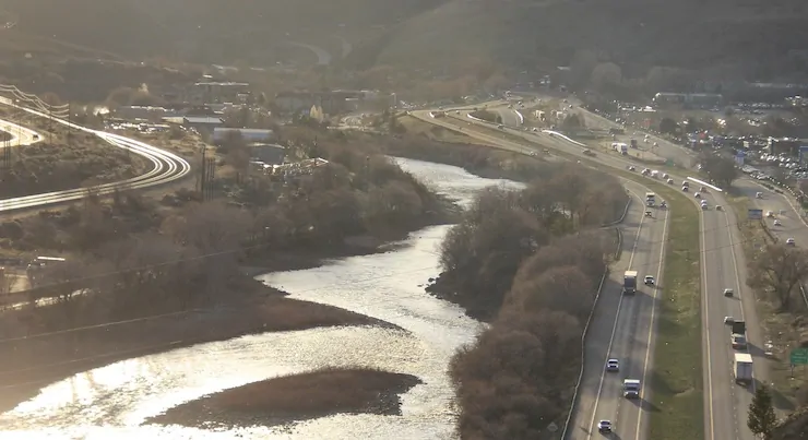
On the evening of November 19, a packed conference room in the Denver West Marriott erupted in cheers when the Colorado Water Conservation Board approved one of the largest ever dedications of water for the environment in Colorado’s history. This new deal, if completed, will ensure that water currently running through the aging Shoshone Hydropower Plant on the Colorado River, deep in the heart of Glenwood Canyon, will keep flowing through the canyon when the plant eventually goes off-line. It’s not a sure thing yet – water court wrangling over the details and financial hurdles remain. But the Board’s action was a crucial step forward.
Currently, when the plant is running full steam, 1,400 cubic feet/ second (think 1,400 basketballs full of water passing by every second) is diverted out of the river into a tunnel and then into massive pipes visible against the canyon walls, where the power of falling water spins turbines to generate electricity. The water is then returned back to the river. Under the new deal, when the plant stops operating (it is over 100 years old and vulnerable to rockfall), the water would instead stay in the river, vastly improving conditions for fish and the bugs they eat in the 2.4-mile reach between the diversion and the powerplant’s return flows. The dedication of the plant’s water rights to that stretch of river would bring benefits that ripple hundreds of miles up and downstream because of the crucial role these water rights play in controlling the river’s flow through Western Colorado.
Shoshone Power Plant, Colorado | Hannah Holm
In Colorado, as in most of the West, older water rights take priority over newer ones when there’s not enough water to satisfy everyone’s claims. On the Colorado River, the Shoshone Hydropower rights limit the amount of water that can be taken out of the river upstream by junior rights that divert water from the river’s headwaters through tunnels under the Continental Divide to cities and farms on the eastern side of the Rocky Mountains. The new deal to enable the Shoshone rights to be used for environmental flows would preserve those limitations on transmountain diversions in perpetuity.
Upstream from the power plant, near the ranching town of Kremmling, Colorado, the river carries less than half the water it would without the existing transmountain diversions. This stresses fish populations and the iconic cottonwood groves that line the river. The Shoshone rights downstream prevent these diversions from being even larger. Because the power plant returns all the water it uses to the river without consuming it, the water continues to provide benefits downstream from the plant to rafters, farms, cities and four species of endangered fish that exist only in the Colorado River Basin. Securing these flows for the future is particularly important as climate change continues to reduce the river’s flow, which has already declined by roughly 20% over the past two decades.
The people cheering in the hearing room represented cities, towns, counties and irrigation districts from up and down the Colorado River. Their entities had pledged ratepayer and taxpayer dollars to help secure the rights in the complex transaction spearheaded by the Colorado River Water Conservation District. Environmental organizations, including American Rivers, Audubon, Trout Unlimited and Western Resource Advocates, were also parties to the hearing and supportive of the deal, but were vastly outnumbered.
The Coloradans cheering in that room were there because their constituents’ livelihoods, clean drinking water and quality of life depend on a living Colorado River. American Rivers is proud to stand with them and will continue advocating for the completion of this historic water transaction.
In a collection of essays and research summaries, eleven members of the Colorado River Research Group (with eight guest contributors) touch on issues as diverse as plummeting reservoir storage, climate change trends, risk management, agricultural water conservation, equity, and governance, all against the backdrop of the need to fashion post-2026 reservoir operating rules.
Chapter 1. Colorado River Reservoir Storage – Where We Stand Jack Schmidt, Anne Castle, John Fleck, Eric Kuhn, Kathryn Sorensen, and Katherine Tara
Chapter 2. Think Natural Flows Will Rebound in the Colorado River Basin? Think Again. Jonathan Overpeck and Brad Udall
Chapter 3. The Erosion of the Colorado River “Safety Nets” is Alarming Doug Kenney
Chapter 4. Water Equity in the Colorado River Basin Bonnie Colby and Zoey Reed-Spitzer
Chapter 5. The Tale of Three Percentage-Based Apportionment Schemes Eric Kuhn
Chapter 6. A Humbly Proffered Proposal to Aid the Colorado River System: Conservation Easements & Land Purchases Kathryn Sorensen and Sarah Porter
Chapter 7. Facing the Future: Can Agriculture Thrive in the Upper Basin with Less Water? Kristiana Hansen, Daniel Mooney, Mahdi Asgari, and Christopher Bastian
Chapter 8. Towards a Basinwide Entity: Moving from Vision to Action Matthew McKinney, Jason Robison, John Berggren, and Doug Kenney
Contributors
Colorado River Research Group (CRRG) Members
Bonnie Colby, Professor, University of Arizona.
John Fleck, Writer in Residence, Utton Transboundary Resources Center, University of New Mexico.
Kristiana Hansen, Professor, Department of Agricultural and Applied Economics, University of Wyoming.
Doug Kenney, Director, Western Water Policy Program, Getches-Wilkinson Center, University of Colorado Law School; and Chair, Colorado River Research Group.
Eric Kuhn, Retired General Manager, Colorado River Water Conservation District.
Matthew McKinney, Co-director, Water & Tribes Initiative; Senior Fellow, Center for Natural Resources & Environmental Policy, University of Montana; Fulbright Specialist 2025-2027.
Jonathan Overpeck, Dean, School for Environment and Sustainability, University of Michigan.
Jason Robison, Professor of Law and Co-Director, Gina Guy Center for Land & Water Law, University of Wyoming.
Jack Schmidt, Director, Center for Colorado River Studies, Utah State University, and former Chief, Grand Canyon Monitoring and Research Center.
Kathryn Sorensen, Kyl Center for Water Policy, Arizona State University; and former Director, Phoenix Water Services.
Brad Udall, Senior Water and Climate Research Scientist/Scholar, Colorado Water Center, Colorado State University.
Guest Contributors
Mahdi Asgari, Postdoctoral Scholar, Department of Agricultural and Applied Economics, University of Wyoming.
Christopher Bastian, Professor, Department of Agricultural and Applied Economics, University of Wyoming.
John Berggren, Regional Policy Manager, Western Resource Advocates.
Anne Castle, Senior Fellow, Getches-Wilkinson Center, University of Colorado Law School; former US Commissioner, Upper Colorado River Commission; and former Assistant Secretary for Water and Science, US Department of the Interior.
Daniel Mooney, Associate Professor of Agricultural and Resource Economics, Colorado State University.
Sarah Porter, Director, Kyl Center for Water Policy, Arizona State University.
Zoey Reed-Spitzer, Research Assistant, North Carolina State University (formerly University of Arizona).
Katherine Tara, Staff Attorney, Utton Transboundary Resources Center, University of New Mexico.
Here’s the preface:
Welcome to the Colorado River Research Group’s (CRRG) inaugural Colorado River Insights report. This publication marks a new (and still evolving) direction for the CRRG, transitioning away from the group-authored policy briefs of the past to more personal “Individual Submissions” that allow members to be more focused, direct and sometimes prescriptive than in the past efforts authored jointly and requiring unanimous consent. While each of the Individual Submissions (i.e., Chapters) that follows is unique in structure and tone and detail, each member was given the same charge: to speak directly about issues on the river where they have been directing much of their current focus, and where feasible, to identify a path forward on those issues. Given this approach, each Individual Submission is truly individual—or, in several cases, the product of small groups—and thus should not be attributed to the entire body, although in practice there is usually very little internal conflict on any of the major themes featured throughout these pages. One byproduct of this approach is that it shines a light on some of the CRRG’s most glaring holes in terms of disciplines and substantive expertise, helping to steer us to new potential members (and guest contributors) and, perhaps, new approaches. Unless or until that happens, we readily acknowledge that our collective snapshot of current and emerging basin issues is far from comprehensive. But how could it be? That’s an impossible standard for a river as vast in size, importance and complexity as the Colorado.
We are hopeful that this new approach can be helpful in better funneling the knowledge emerging from the research community into the hands of decision-makers, journalists, NGOs, water users, and other concerned parties in a more hands-on position to implement the changes needed to restore the economic and environmental sustainability of the River. Clearly, we are in an era screaming for new ideas and new approaches; the status quo isn’t working. — Doug Kenney, CRRG Chair
Map of the Colorado River drainage basin, created using USGS data. By Shannon1 Creative Commons Attribution-Share Alike 4.0
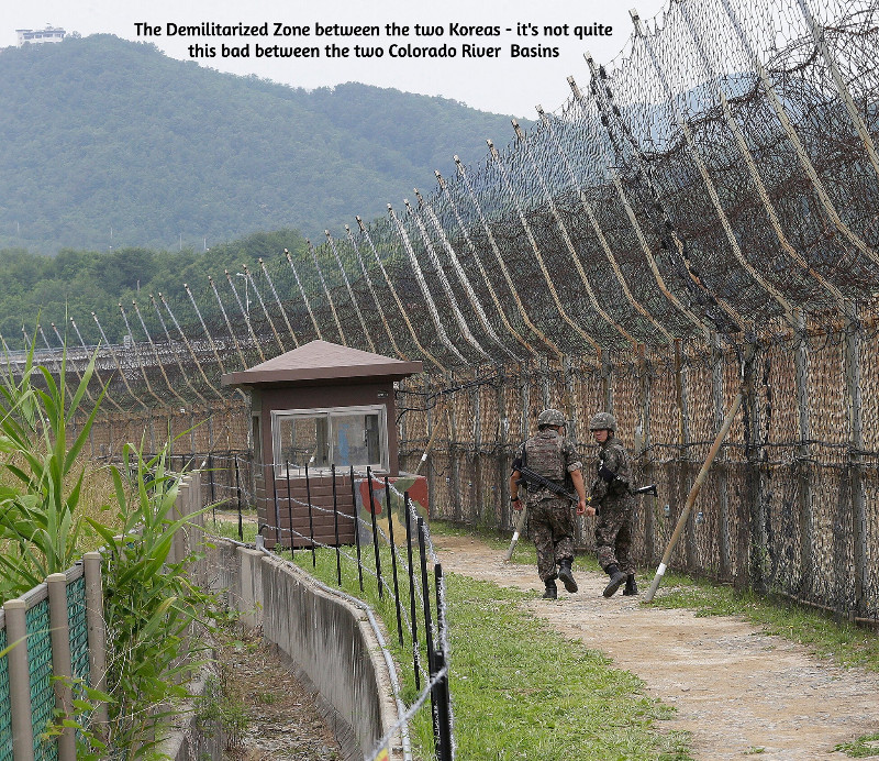
Negotiations among the Magnificent Seven representing the seven states of the Colorado River region begin to resemble the ongoing negotiations between the military and diplomatic representatives for North and South Korea, where negotiations for something beyond an armistice have been going on for more than sixty years. Here, as there, the negotiations have reached a stalemate, and both sides are now engaged in an information war. Between the two Koreas, this war takes the form of everything from huge arrays of speakers blasting pop music across the demilitarized zone to smuggled USB drives with movies and TV shows. Here, it is mostly just propaganda bombs tossed over our ‘DMZ,’ the Grand Canyons, about each side’s virtue and the other side’s obstinacy, depending on their regional media’s love of conflict and tendency to support the home team. The missed November deadline has been seamlessly replaced – as we all suspected it would be – by a February deadline. But otherwise – nothing new on that front. We can just hope it doesn’t go on for another fortysome years.
So I’m going to take advantage of the stalemate to ask the reader to think about a bigger picture that may be more interesting. It stems from a comment from my partner Maryo, from whom I learn too much to dismiss anything she says. ‘Why are you “romancing the river”?’ she asked the other day. ‘Romance is such a cheapened concept today – bodice-ripping stories of ridiculous antagonistic love. You’re undermining the value of your work, calling it a “romance.”’
‘Well,’ I said – figuring that if she feels that way, maybe my readers raise the same question – ‘maybe one of the things a writer ought to try to do is restore the value of words and the concepts they once represented that have become devalued through misuse.’ Spoken like a true Don Quixote, another old man who took arms, sort of, against abuse of the concept of ‘romance.’
I do think that one of the things that ‘civilization’ does in civilizing us is to simplify things for us, including words whose complexity and depth embrace concepts, ideas and feelings that can be inconvenient to an orderly civilized society. A ‘romance,’ from the medieval era on into the early 20th century, was a story of an adventure in pursuit of something mysterious, exciting, challenging, something beyond everyday life. That could be the pursuit of a love relationship that was life-changing (and maybe life-endangering) for its participants – Tristan and Isolde, Launcelot and Guinevere, Romeo and Juliet, Bonnie and Clyde.
But on a much larger scale, the romantic adventure can be establishing a relationship with anything outside of ourselves that intrigues or challenges us. The relationship can emerge with a place, a house, a horse, a car, a continent, a river, an idea, as well as another person, anything that intrigues us, wakes up our imagination – arational or prerational relationships that make the civilizing forces nervous. The relationship can run the quick dynamic spectrum from arational love to its flip side arational hate, through all the intermediary love-hate variations. It can also have a mythically selective or even creative attitude toward the gray-zone relationship between ‘truth’ and fact. Which leads those trying to develop an orderly civilization to dismiss anything (ad)venturing into the mythic as a lie. It just seems simpler that way.
The Powell survey on its second trip down the Colorado River, 1871. Photo credit: USGS
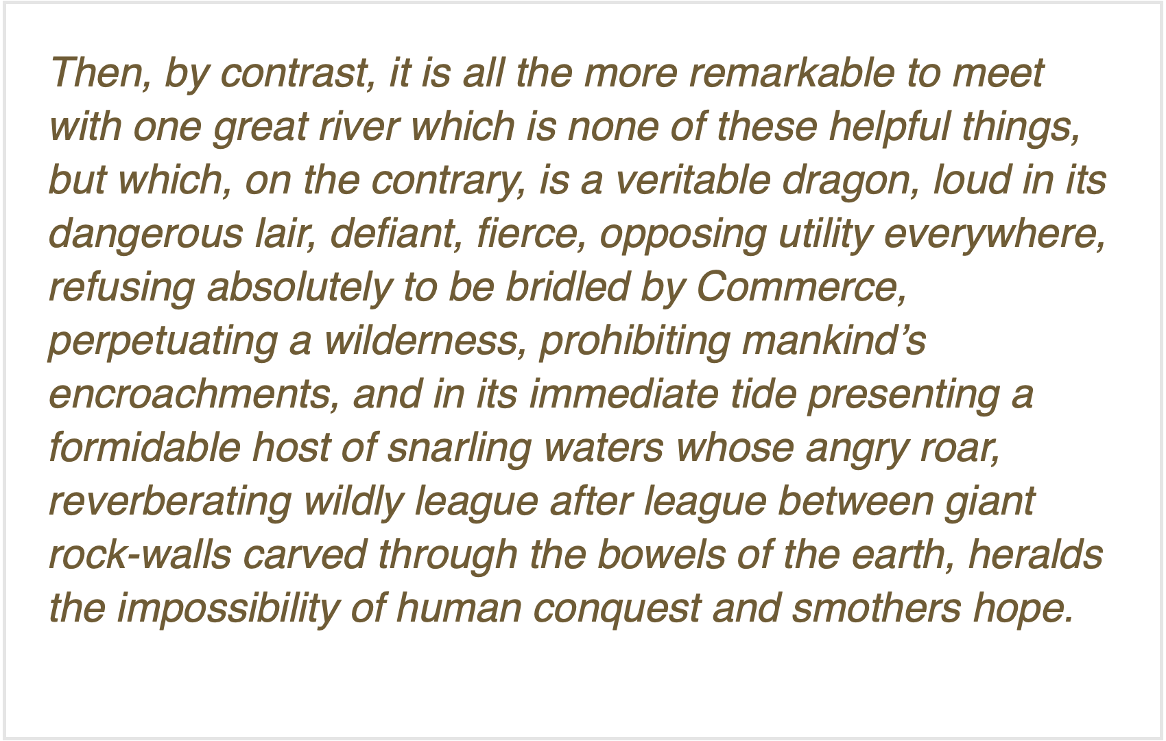
The first comprehensive study of the Colorado River region was uncivilized enough to state upfront its romantic origins: Frederick Dellenbaugh’s Romance of the Colorado River. Dellenbaugh’s book (available online for a pittance) delved as deeply as was possible at that time into both the First People prehistory in the region and the early history of the Euro-American invasion, from the Spanish trying to work their way up the river from its contentious confluence with the Gulf of California (‘Sea of Cortez’ to them) to the trappers imposing the first major Euro-American change on the river, stripping its tributaries of their beavers which increased the size and violence of the river’s annual spring-summer runoff of snowmelt. But the heart of the book is John Wesley Powell’s explorations to link the upper river and the lower river through its canyons.
Dellenbaugh, as a seventeen-year-old, accompanied Powell on his second Colorado River expedition, a ‘baptism under water’ (often literally) that shaped his ‘romantic’ vision. In his ‘Introduction,’ after observing that most of the great rivers that humans encountered in exploration and settlement gradually became like foster parents to those who settled along them, carrying goods for them and generally watering and growing their settlements, he says of the Colorado:
Dellenbaugh’s Romance was published in 1903. That same year, another great southwestern writer, Mary Hunter Austin came out with her Land of Little Rain, a fascinating collection of her explorations in the deserts of the lower Colorado River region. In that book she offered what might be a cautionary note about ‘romancing the river,’ in an observation about a small Arizona tributary of the Colorado River, ‘the fabled Hassayampa… of whose waters, if any drink, they can no more see fact as naked fact, but all radiant with the color of romance.’
I will now indulge my tendency to take a ‘tectonic’ look at history – looking for large chunks colliding or grating together or subducting under each other. I see the history of our engagement with the Colorado River dividing into three ‘tectonic romances’: first, the Romance of Exploration, which is chronicled in a couple different ways by those two explorers, Dellenbaugh and Austin; their 1903 publications summarize that age and put a semi-colon at the end of the period, as it were.
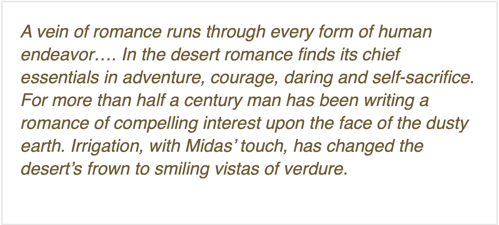
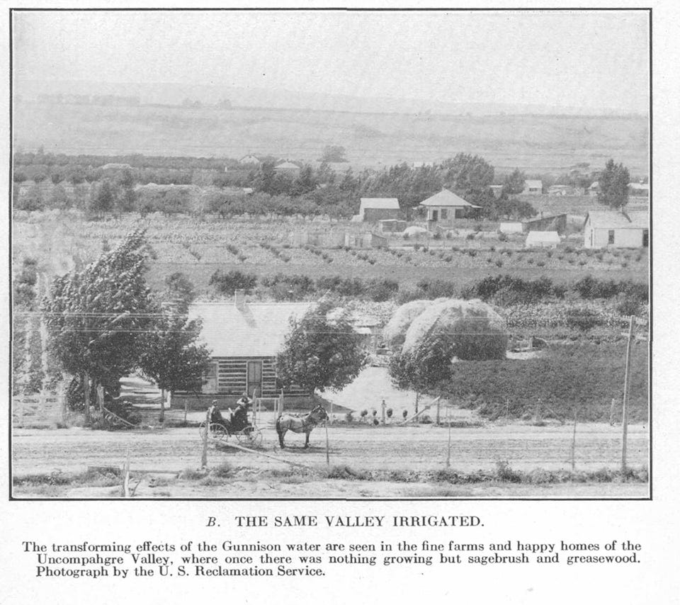
Second, the Romance of Reclamation: 1903 also marks the year the U.S. Reclamation Service came into being, an organization created almost specifically for settling the Colorado River deserts. Civilized people on both sides of the question would deny that there was any ‘romance’ to reclamation, but one early Bureau engineer would publicly disagree, writing in 1918 about ‘the romance of reclamation’:
C.J. Blanchard of the U.S. Reclamation Service authored that steaming verdure. The Service at that time was under the U.S. Geological Survey, a scientific organization disciplined to the ‘look before you leap’ methods of science, discerning the reality of a situation and adapting to that; but the Reclamation Service, frustrated by the seasonal flood-to-trickle flows of the Colorado, thought that changing that reality (through storage and redistribution) was a more promising route than adapting to it, and so was on its way to becoming independent of the USGS when Blanchard wrote his ‘romance of irrigation’ for an educational journal called The Mentor(thanks, Dave Primus, for calling it to my attention).
Members of the Colorado River Commission, in Santa Fe in 1922, after signing the Colorado River Compact. From left, W. S. Norviel (Arizona), Delph E. Carpenter (Colorado), Herbert Hoover (Secretary of Commerce and Chairman of Commission), R. E. Caldwell (Utah), Clarence C. Stetson (Executive Secretary of Commission), Stephen B. Davis, Jr. (New Mexico), Frank C. Emerson (Wyoming), W. F. McClure (California), and James G. Scrugham (Nevada) CREDIT: COLORADO STATE UNIVERSITY WATER RESOURCES ARCHIVE via Aspen Journalism
The best-known document of the Romance of Reclamation was of course the Colorado River Compact – a document in which the romance of reclamation overrode any relationship to ‘naked fact’ about the river and its flows, a situation that is now biting our collective ass.Yet an Arizona water maven said recently that any Bureau of Reclamation solution to the seven-state impasse would have to cleave closely to the Compact…. The history of the Romance of Reclamation has been written in the gaggle of Congressional acts, court decisions, treaties, regulations and directives that make up the ‘Law of the River’ (recitations of which never seem to include the 1908 Winters Doctrine allocating assumed water to federal reservations, including to the First Peoples).
The end of the Romance of Reclamation would be in the 1960s, pick your date: publication of Rachel Carson’s Silent Spring in 1962, passage of the Wilderness Act in 1964, passage of the Environmental Policy Act in 1969 – a decade in which the general American perception of the West underwent a sea change, from seeing it as a workplace for producing the resources to feed the American people and industries, to seeing it as a great natural playground to which America’s predominantly urban population could go to recharge, with a resulting desire to protect it from the very industrial consumption that supported the American ‘lifestyle.’.
This was the dawn of the third romantic epoch in our relationship with the river (and the continent in general) – the Romance of Restoration and Revision, driven by a belief that we have sinned against capital-N Nature – with many naked facts as evidence – and can only expiate our sins by preserving what remains of the nonhuman environment, restoring what we can of the damage we’ve done, and revising our own systems for consuming nature (e.g., renewable energy).
Aesthetics are at the root of our romance with capital-N Nature, aesthetics best served by the (increasingly rare) opportunity to be alone with and ‘silent on a peak in Darien,’ as Keats put it. We have a large (and growing) number of excellent writer[s] who work to elaborate on that aesthetic – Ed Abbey first, Craig Childs, Heather Hansman, Kevin Fedarko, to name a few.
But the aesthetic yearning to ultimately ‘put it back the way it was’ does not extend to other equally naked facts, like the dependence of the outdoor recreation industries on the creation of big mountain-highway traffic jams pumping big quantities of carbon and nitrogen gases into the already overladen atmosphere, as we all load up our cars with expensive gear to go off to commune with Nature. Or the naked fact that maintaining civilization-as-we-know-it for 300 million people involves a lot of nonrewable extraction from Nature that it will be very difficult to move away from entirely – unless we figure out how to control our breeding.
Just as significant achievements were achieved under the Romance of Reclamation, so significant achievements have been achieved under the Romance of Restoration and Revision – the setting aside of millions of acres of still-sort-of-wild land, instream flow laws, increasingly responsible forest management, et cetera. But we are clearly still in the early transition – half a century later – to a more realistic romance with restoring and revising to a kinder gentler relationship with the nonhuman systems of nature. And right now, we are experiencing a major counter-attack from the societal forces whose aesthetics still imagine a ‘working landscape’ of derricks, mines and other industrial-scale harvests, all suffused with the ‘smell of money,’ societal forces that believe the best of times were before we woke up to the increasingly fragile finitude of our planet under the burden of us. Let’s all go back and make America great again!
The back of Glen Canyon Dam circa 1964, not long after the reservoir had begun filling up. Here the water level is above dead pool, meaning water can be released via the river outlets, but it is below minimum power pool, so water cannot yet enter the penstocks to generate electricity. Bureau of Reclamation photo. Annotations: Jonathan P. Thompson
I cannot now imagine when and how this third epoch of our romance with the river will end. I think this aesthetic romance might peak with the ‘breaching’ of Glen Canyon Dam, an action that has taken on a somewhat mythic quality for today’s river romantics. I don’t think we will tear it down – let it stand as a monument to…something. But I suspect that even the Bureau of Reclamation is exploring some way of tunneling around it at river level, as we continue to flirt with the disaster of dead pool behind the dam. It will not be easy, due to the silt already piled up at the dam – but really, nothing is going to be easy anymore; that blessed civilization is now in the rear-view mirror.
I’m going to take advantage of the lull in the short-term news about the river’s management for maybe the next decade, to take a look at each of these three epochs of ‘romancing the river’ and their relationship to the ‘naked facts’ of the river – mostly see if there might be something there we’ve overlooked that might help us move forward in our ever-emerging relationship of this ‘First River of the Anthropocene.’ Onward and outward.
Map of the Colorado River drainage basin, created using USGS data. By Shannon1 Creative Commons Attribution-Share Alike 4.0
Click the link to read the article on the Big Pivots website (Allen Best):
December 2, 2025
Changing a name is simple enough, if somewhat expensive and time-consuming, at least in the case of businesses.
But what to make of the National Renewable Energy Laboratory’s new name? Is the change all bad for the laboratory and for its mission of the last 34 years?
It became National Laboratory of the Rockies as of Monday. It had been known as NREL since 1991 and before that had been the Solar Energy Research Institute since its founding in 1977 during the presidency of Jimmy Carter.
The laboratory has become one of the nation’s — and perhaps the world’s — seminal institutions devoted to engineering an energy transition. As of October, it had 3,717 employees after a reduction of 114 during May.
“Clearly an effort is underway (by President Donald Trump)‚ to downplay renewable energy as a premier, viable energy source in the United States. So it is hard to separate the politics from this given the timing,” said David Renee, who worked at the laboratory from 1991 until his recent retirement.
Renee said that in part he was very disappointed to see the words “renewable energy” deleted from the name but does see the new name allowing the institution to broaden its mission to reflect needs of the ever-more-complex electrical grid.
“I can see some good, long-term benefits from this. It gives the laboratory flexibility to have a broader scope,” he said. “A lot of the work is not exclusively related to renewable energy but more related to grid reliability and expansion, of which renewables play an important part. So one could argue that the name change was overdue anyway in order to be consistent with other national laboratories, which are mostly named for their locations and not the technology.”
The United States has 17 national laboratories engaged in energy and other research, and most are named for their local geographies. New Mexico, for example, has the Sandia and Los Alamos labs, the former named for a mountain range and the latter a town. Renee arrived in Golden from the Pacific Northwest National Laboratory and retired after running the solar resource assessment program.
Ron Larson, one of the earliest employees of the solar institute who arrived in 1977, a time when solar was 100 times more expensive than it is now, also tends toward a charitable view of the name change.
A possible reason, and a valid one, he said, could be that other national labs wanted more to do on renewable energy topics and are qualified to do so. “Too, maybe some at NREL have wanted to expand into other sectors, including fossil fuels and nuclear.”
Peter Lilienthal, an NREL employee from 1990 to 2007, when he formed an energy-related business, was less charitable. He was incensed by a statement from Audrey Robertson, the assistant secretary of energy, in Monday’s announcement.
“The energy crisis we face today is unlike the crisis that gave rise to NREL,” Robertson said. “We are no longer picking and choosing energy sources. Our highest priority is to invest in the scientific capabilities that will restore American manufacturing, drive down costs, and help this country meet its soaring energy demand. The National Lab of the Rockies will play a vital role in those efforts.”
Lilienthal called that statement gaslighting. “That is just not true,” he said of Robertson’s assertion about no longer picking energy sources. He points to the promises of President Donald Trump on the campaign trail and elsewhere to restore fossil fuels and discourage renewable energy. This, he said, will slow the energy transition away from fossil fuels, he believes.
Jud Virden, the director of the renamed laboratory since October, said the new name “embraces a broader applied energy mission entrusted to us by the Department of Energy to deliver a more affordable and secure energy future for all.”
That statement clearly fits in with the narrative of Chris Wright, the Colorado-born director of the Department of Energy. A graduate of Cherry Creek High School, in south Denver, Wright was a rock climber and skier before going to the Massachusetts Institute of Technology to study engineering, first mechanical and then electrical. He also later studied at the University of California at Berkeley.
In April, Wright returned to Colorado to tour NREL. Afterward, he met with reporters, where he said that he had worked on solar energy during graduate school and then geothermal. Only later, needing a paycheck, did he begin work in the oil and gas industry. In Denver, he founded Liberty, an oil and gas field services company, in 2011.
In his remarks, Wright did not dismiss renewable energy, but he did — as he had done before — dismiss “climate alarmism.” He said the science does not support the perception of risk that has, in part, driven the work to make renewable energy affordable and integrated into the electrical grid.
Wright sees the need for more energy being paramount and climate change worries a hindrance to archiving that plentitude that will result in higher standards of living.
“The biggest barrier to energy development the last few decades is people, for political reasons, calling climate change a crisis,” he claimed.
He went on to cite 3 million people dying every year because they don’t have clean cooking fuels or the 4 or 5 million people dying because they don’t have sufficient food as well as the disconnect notices to American consumers for non-payment.
“If you call climate change a crisis and you don’t look at any data, you can pass laws to do anything.
Chris Wright has argued that energy scarcity poses a greater threat to quality of life than climate change. Here, he speaks to reporters in April 2025 while Martin Keller, then the director of NREL, looks on. Photo/Allen Best. Top image/National Laboratory of the Rockies.
In an essay published in The Economist in July, Wright said much the same thing.
Wright also talked about the need to deliver plentiful energy and lowering energy prices. He talked about the drive to integrate artificial intelligence data centers into the U.S. economy.
“Artificial Intelligence is critical. This is a phenomenal new technology. People are seeing the great consumer services it provides, the business efficiencies it provides, and we are very early on.”
And again, he talked about the need to expand electrical production as necessary to support artificial intelligence. Even without strong demand for data centers, he said, electricity prices have been rising.
“We’ve seen 20 to 25% rise in the price of electricity over the last four years. Americans are mad and angry and upset about that, which is why they’re all worried about AI — ‘No, we don’t want new demand on our grid that’s just going to make our prices more expensive.’ — We need to show them we can walk and chew gum at the same time. We’ve got to grow our electricity production capacity without raising the prices to consumers, and we’ve got to keep our grid stable, not just the complicated system stable, but the increasing cyber threats of people that want to do us harm on our grid.”
Chuck Kutscher took a broad view of the change. A mechanical engineer by training, he began working at NREL in the 1980s before retiring in 2018.
“NREL is widely viewed as the leading renewable energy laboratory in the world. In the U.S. and throughout the world, solar and wind dominate the new electricity generation being deployed because they are now the lowest in cost and are also the fastest to deploy, in addition to avoiding air pollution and greenhouse gas emissions. China is clearly the world leader in renewable energy development and deployment, but NREL has played a critical role in keeping the U.S. competitive,” he said in a statement.
“As a Department of Energy lab, NREL takes direction from DOE. The current administration made it clear in the last election that it would support fossil fuels. DOE does have a lab that focuses primarily on fossil fuels, the National Energy Technology Lab, so continuing to have a lab that performs R&D on renewables makes perfect sense, especially given the transition to renewable energy happening around the world. I’m sure the new lab director is working hard to preserve NREL’s tremendous expertise and important work in renewable energy while at the same time being responsive to DOE directives to strengthen the lab’s portfolio in areas such as AI and data centers.”
The Crossing Trails Wind Farm between Kit Carson and Seibert, about 150 miles east of Denver, has an installed capacity of 104 megawatts, which goes to Tri-State Generation and Transmission. Photo/Allen Best
In Brief Unusually wet conditions in the Basin in October and November 2025, combined with reduced releases from some reservoirs, led to a basin-wide increase in storage for the two-month period. The combined contents of Lake Powell and Lake Mead increased during the two months for only the second time since 2010, and storage in the San Juan River basin increased by 19%, especially in Vallecito and Navajo Reservoirs. These changes were a welcome respite from the relentless depletion of storage that has dominated the last few years. Nevertheless, the upcoming winter snow season is predicted to be below average, and total active storage in the Basin is less than a 2 year supply when compared with recent Basin-wide consumptive uses and losses.
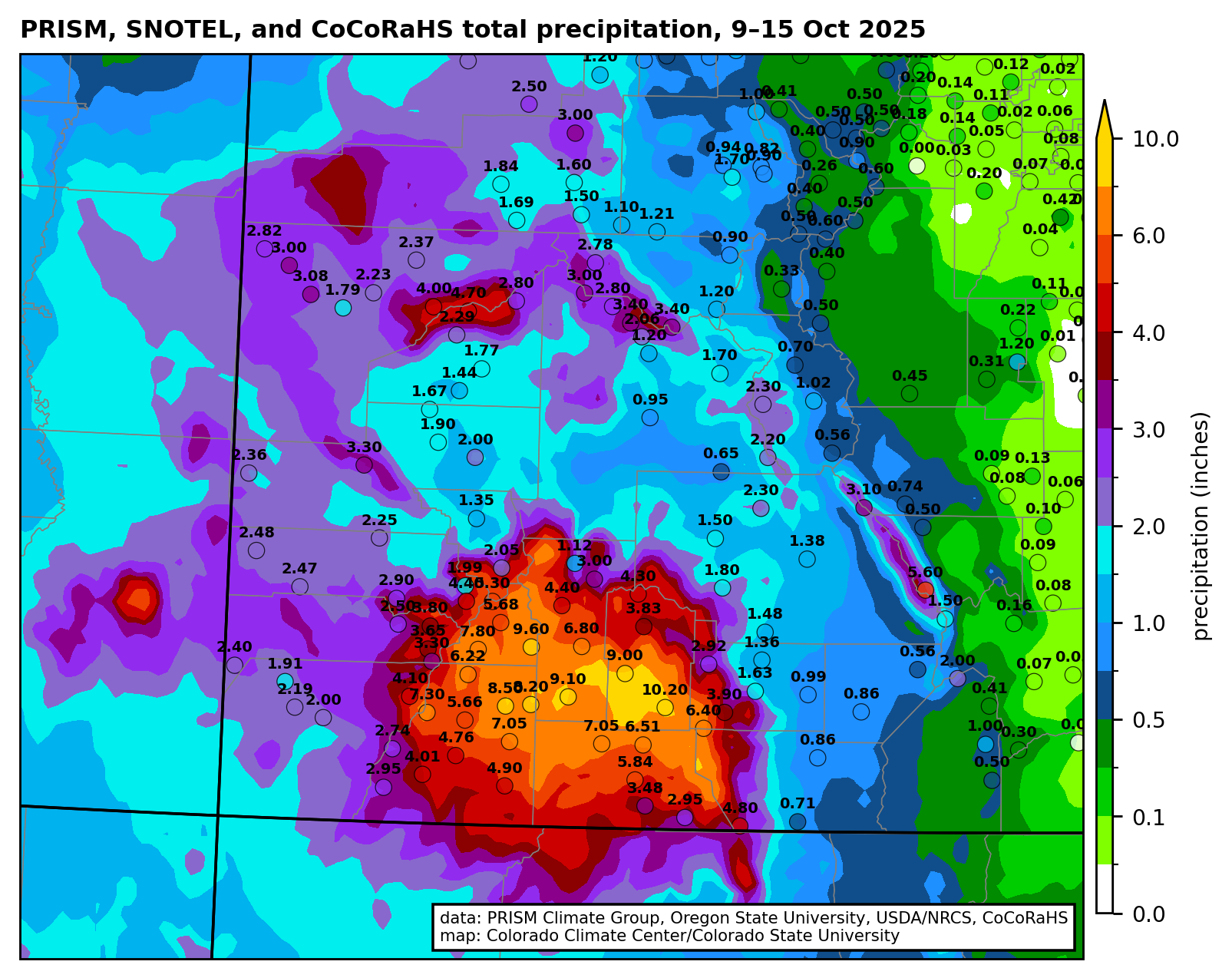
Total precipitation (inches) from 9-15 October 2025 with gridded data from the PRISM Climate Group and observations from the Community Collaborative Rain, Hail, and Snow (CoCoRaHS) network. Credit: Russ Schumacher/Colorado Climate Center
The Details
The rains of October and November 2025 slowed depletion of the Colorado River’s reservoirs due to increases in stream flow and reduced reservoir releases in some places. Water levels rose in a few reservoirs, and autumn’s rains provided a small bit of flexibility for water managers at the beginning of what is likely to be a below-average winter snow season.
As of November 30, the Basin’s 46 reservoirs held 24.63 million af (acre feet) of active storage[1], of which 90% was in 12 federal reservoirs,[2] including 15.00 million af in Lake Powell and Lake Mead (hereafter, Powell+Mead) and 4.88 million af in 8 federal reservoirs upstream from Lake Powell (Fig.1). This amount of storage is similar to conditions in early 2022, a situation that was described at that time as a crisis. If we divide the total active storage in the Basin’s 46 reservoirs by the basin-wide total annual rate of consumptive use and loss that was 12.7 million af in 2024, the basin-wide reservoir water supply would sustain Basin-wide use for less than 2 years. We continue to live at the doorstep of crisis.
Figure 1. Graph showing active storage in Colorado River basin reservoirs between January 1, 2021, and November 30, 2025. Credit: Jack Schmidt/Center for Colorado River Studies
Basin-wide reservoir storage stabilized in October and November, because Powell+Mead storage stabilized and storage in the San Juan River basin increased. Total Inflow to Lake Powell exceeded releases for more than one week between October 11 and October 18, when Lake Powell increased by 105,000 af[3] which is a 1.6% gain (Fig. 2). Approximately 40% of the total inflow came from the San Juan River, and the monthly October inflows were the largest since 2015. The gain in storage in Lake Powell during this weeklong period exceeded depletions during the rest of the month, and Lake Powell gained approximately 52,000 af during the month. Lake Powell lost 147,000 af in November.
Figure 2. Graph showing inflow and outflow from Lake Powell and active storage between October 1 and November 30, 2025. Total monthly flow at Lees Ferry, representing the total releases from Lake Powell, were 490,000 af in October and 501,000 af in November. Credit: Jack Schmidt/Center for Colorado River Studies
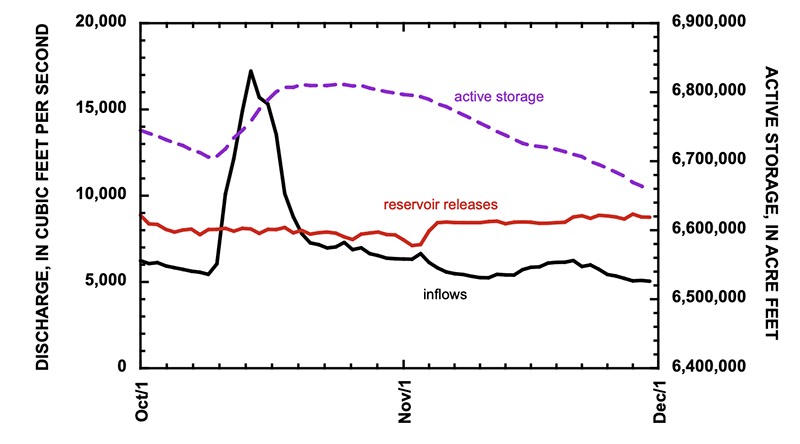
In contrast, the autumn rains did not significantly increase inflow to Lake Mead, because most of the inflows come from scheduled releases from Lake Powell. These reservoir releases were supplemented by 101,000 af of inflows downstream from Lees Ferry[4] and 8000 af from the Virgin River.[5] The most significant changes in Lake Mead occurred at the end of November when releases from Hoover Dam were significantly reduced (Fig. 3).
Figure 3. Graph showing inflow and outflow from Lake Mead and active storage between October 1 and November 30, 2025. Total monthly flow inflow of the Colorado River, representing the total releases from Lake Powell and inflows within Grand Canyon, were 574,000 af in October and 550,000 af in November. Reservoir releases from Hoover Dam were 485,000 af in October and 415,000 af in November. Withdrawals and return flows of the Southern Nevada Water Authority were not included in these data. Credit: Jack Schmidt/Center for Colorado River Studies
Together, total active storage in Powell+Mead increased by 63,000 af during October,[6] and decreased by only 38,000 af in November (Fig. 4).[7] More significant than the gains, however, was that the the pace of reservoir depletion was significantly slowed. Storage in Powell+Mead increased by approximately 25,000 af in October and November, only the second time since 2010 that total storage in these two reservoirs increased during these two months.[8]
Figure 4. Graph showing active storage in Lake Powell, Lake Mead, and in Powell+Mead between January 1, 2023, and November 30, 2025. Credit: Jack Schmidt/Center for Colorado River Studies
Reservoir storage in the San Juan River basin increased more than in any other part of the Colorado River Basin. Five San Juan basin reservoirs increased by 197,000 af in October and November, mostly in Navajo and Vallecito Reservoirs.[9] Not much happened elsewhere, however. The 21 reservoirs of the upper Colorado River watershed lost 57,000 af during October and November, and 16 reservoirs in the Green River watershed lost 10,000 af during the same period.
[2] Taylor Park, Blue Mesa, Morrow Point, Crystal, Fontenelle, Flaming Gorge, Vallecito, Navajo, Lake Powell, Lake Mead, Lake Mohave, and Lake Havasu.
[3] Inflow to Lake Powell was computed as the sum of mean daily discharge of the Colorado River at Gypsum Canyon near Hite (gage 09328960), Dirty Devil River above Poison Springs near Hanksville (09333500), Escalante River near Escalante (09337500), and San Juan River near Bluff (09379500), as reported by the U.S. Geological Survey. Outflow from Lake Powell was computed as the mean daily discharge of the Colorado River at Lees Ferry (09380000), because stream flow is measured 15 miles downstream from the dam and includes ground-water seepage around the dam. Lake Powell storage increased between October 10 and October 20, as reported by Reclamation.
[4] Inflows within Grand Canyon were calculated as the difference between measurements of the Colorado River at Lees Ferry (09380000), Colorado River above Diamond Creek near Peach Springs (09420000), and Diamond Creek nr Peach Springs (09404208).
[5] Virgin River below confluence Muddy River near Overton (09419530)
[6] Between October 1 and November 1, 2025, active storage in Lake Powell increased 52,000 af and 11,000 af in Lake Mead.
[7] Between November 1 and November 30, active storage in Lake Powell decreased by 147,000 af and increased by 109,000 af in Lake Mead.
[8] During the previous 15 years between 2010 and 2024, total storage in Powell+Mead increased by 36,000 af in 2011. During the other 14 years of that period, the median depletion of Powell+Mead was 436,000 af.
[9] Storage in Navajo Reservoir increased 126,000 af between October 9 and November 8 and increased by 114,000 af in October and November. Active storage in Vallecito Reservoir gained 68,000 af in October and November. At the end of November, Navajo Reservoir was 60% of its 1.65 million af capacity. Vallecito Reservoir was 77% of its 125,400 af capacity.
Map of the San Juan River, a tributary of the Colorado River, in Arizona, Colorado, New Mexico and Utah, USA. Made using USGS National Map data. By Shannon1 – Own work, CC BY-SA 4.0, https://commons.wikimedia.org/w/index.php?curid=47456307
Welcome to the Landline, a monthly newsletter from High Country News about land, water, wildlife, climate and conservation in the Western United States. Sign up to get it in your inbox. Screenshot from the High Country News website.
This is an installment of the Landline, a monthly newsletter from High Country News about land, water, wildlife, climate and conservation in the Western United States. Sign up to get it in your inbox.
In early November, Texas-based New Era Energy & Digital announced plans to build a “hyperscale,” meaning massive, AI-processing data center complex in Lea County, New Mexico, the epicenter of the Permian Basin oil and gas drilling boom. The campus will be so big, and use so much power, that, if and when it is built, it will come with its own nuclear and gas power plants, with a mind-blowing combined generation capacity of about 7 gigawatts. That’s like piling the West’s largest nuclear and natural gas plants — Palo Verde and Gila River, both near Phoenix — on top of one another, and then adding another 800 megawatts. That kind of power could electrify something like 5.3 million homes, though these power plants’ output presumably will all go toward more pressing requirements: processing movie streaming, doomscrolling, social media posting and, especially, AI-related activities. [ed. emphasis mine]
Despite the enormity of this proposal, it has received very little news coverage. This is not because anyone is trying to keep it secret, but rather because such announcements have become so common that it’s hardly worth mentioning every new one. New Era’s hyperscale server farm and others like it are still a long way from generating and then devouring their own electricity. But even if only a fraction of the current proposals succeed, they will transform the West’s power grid, its landscapes and its economies as significantly as the post-World War II Big Buildup, when huge coal plants and hydroelectric dams sprouted across the region to deliver power to burgeoning cities via high-voltage transmission lines.
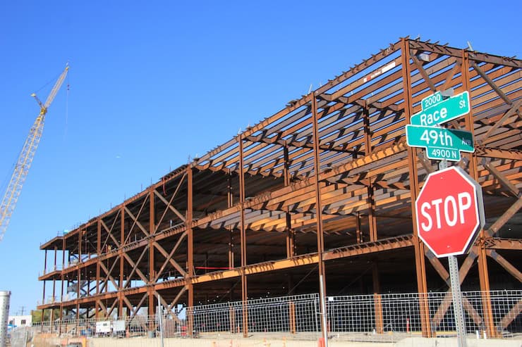
Data center construction at 49th & Race, Denver. Photo credit: Allen Best
In fact, this transformation is already underway. A new report from the nonprofit NEXT 10 and University of California Riverside found that, in 2023, data centers in California pulled 10.82 terawatt-hours of electricity — 1 terawatt equals 1 trillion watts — from the state’s grid, or about enough to power 1 million U.S. households. This resulted in about 2.4 million tons of carbon emissions, even with California’s relatively clean energy mix. (On more fossil fuel-reliant grids, the emissions would have been twice that, or even more.) These same centers directly and indirectly consumed about 13.2 billion gallons of water for cooling and electricity generation. In Silicon Valley, more than 50 data centers accounted for about 60% of one electricity provider’s total load, prompting the utility to raise its customers rates to fund the transmission and substation upgrades and new battery energy storage the facilities required.
These facilities are also colonizing cities and towns far from Big Tech’s Silicon Valley epicenter. Over 100 data centers — structures that resemble big-box stores overflowing with row after row of computer processors — have already sprung up in Phoenix-area business parks, and the planned new ones could increase Arizona’s total power load by 300% over current levels, according to utilities. Recently, Arizona Public Service announced it would keep burning coal at the Four Corners Power Plant beyond its scheduled 2031 retirement to help meet this growing demand.
Data center developments around the West include:
NorthWestern Energy signed on to provide up to 1,000 MW of power — or nearly all of the utility’s generating capacity — to Quantica Infrastructure’s AI data center under development in Montana’s Yellowstone County.
The 290-mile Boardman-to-Hemingway transmission project under development in Idaho and Oregon was initially designed to serve about 800,000 PacifiCorp utility customers. But in October it was revealed that the line now will deliver all of its electricity to a single industrial customer in Oregon, most likely a new data center.
In September, an NV Energy executive told a gathering in Las Vegas that tech firms are asking the utility to supply up to 22,000 megawatts of electricity for planned data centers. Since the utility has largely moved away from coal, this new load would likely be met by generation from existing and planned natural gas facilities, along with proposed utility-scale solar installations.
Xcel Energy expects to spend about $22 billion in the next 15 years to meet new data centers’ projected power demand in Colorado, potentially doubling or even tripling legacy customers’ rates. Xcel and the state’s public utilities commission are currently working to reverse the planned closure of a coal plant due to projected data center-associated electricity shortages.
Wyoming officials are doing their best to lure data centers and cryptocurrency firms to the state, and it seems to be working. This summer, Tallgrass proposed building an 1,800 MW data center, along with dedicated gas-fired and renewable power facilities, near Cheyenne. It would add to Meta’s facility in Cheyenne and the 1,200 MW natural gas-powered Prometheus Hyperscale data center under development in Evanston. Observers say electricity demand from these centers could transform the physical and regulatory utility landscape and potentially drive up costs for “legacy” customers.
New Mexico utilities are struggling to meet growing demand from an increasing number of data centers while also complying with the state’s Energy Transition Act’s requirements for cutting greenhouse gas emissions.
Doña Ana County approved tax incentives for Project Jupiter, a proposed $165 billion data center campus in Santa Teresa in the southeastern corner of New Mexico. Developers have indicated they plan on building dedicated power generation, though they have not yet disclosed the energy sources.
Numerous companies are eyeing Delta, Utah, as a site for new data centers, drawn by the area’s relatively cheap land, existing agricultural water rights and the fact that it’s home to the Intermountain Power Project, a colossal coal plant built during the original Big Buildup in the years after World War II. The plant is scheduled to be converted to run on natural gas and, ultimately, hydrogen, but Utah lawmakers want at least one of its units to continue to burn coal. They just need a buyer for the dirty power it would produce, and data centers could fit the bill. Fibernet MercuryDelta is looking to construct the 20 million-square-foot Delta Gigasite there, and Creekstone Energy plans to manage 10 gigawatts of capacity there, with power coming from coal, solar and natural gas.
The Intermountain Power Project plant in Delta, Utah. The plant was scheduled to be converted away from coal, but Utah lawmakers want it to continue to burn coal. They need a buyer for the dirty power, and data centers could fit the bill. By Doc Searls from Santa Barbara, USA – 2014_11_21_lhr-lax_330, CC BY 2.0, https://commons.wikimedia.org/w/index.php?curid=38536818
The Western power grid is interconnected but also divided into 38 balancing authorities, or grid operators. Nearly every one of them is expected to see an increase in data center-driven demand over the next decade or so as the Big Digital Buildup gains steam, and few of them are currently equipped to meet that demand. In fact, the North American Electricity Reliability Corp. warned this month that growing data center-driven power demand is increasing the risk of outages this winter in parts of the West. Therefore, many of the largest data centers are going to need to generate their own power, while utilities also will have to scramble to add generating capacity and associated infrastructure as quickly as possible to serve the region’s on-grid facilities. The costs of that new infrastructure will be borne by each utility’s ratepayers.
How will the needed power be generated?
There’s simply no way utilities and developers can meet the projected demand with solar and wind, alone. So, utilities are already making plans to keep existing coal plants running past previously scheduled retirement dates, and to build new natural gas plants and even nuclear reactors. Yes, nukes: Google, Switch, Amazon, Open AI and Meta are all looking to power proposed facilities with the new — so new they have yet to be developed — crop of small, modular and advanced reactors, if and when they are finally up and running.
Can data centers be “sustainable”?
These developments will have environmental consequences, some more than others. Fossil fuel burning feeds climate change and pollutes the air, and oil and gas drilling and coal mining ravage landscapes; utility-scale solar and wind facilities can harm wildlife habitat and often require hundreds of miles of new transmission lines to move the power around; and nuclear power comes with unique safety hazards and a nagging radioactive waste problem, while the uranium mining and milling industry risks reenacting its deadly Cold War legacy. Even a facility that gets all of its power from solar and batteries is still using resources that, without the extra demand, would otherwise be replacing fossil fuels on the grid. And, unless it has a closed-loop air-cooled system, the data center will still consume water for cooling, usually from municipal drinking water systems.
Wyoming-based Prometheus Hyperscale has made waves with its ambitious and seemingly visionary talk of building “sustainable” data centers with dedicated clean energy generation, water recycling and efficient cooling systems that would capitalize on the cold in the Northern Rockies. It’s even talked about harnessing the heat from the servers to warm greenhouses and shrimp-farming operations. Maybe, one day, the power will be supplemented by nuclear micro-reactors. But so far, the company’s walk is not exactly matching its talk. In the beginning, at least, the facility will run on natural gas, and Prometheus says it will offset carbon emissions by paying another company to capture and sequester carbon dioxide from biofuel plants in Nebraska.
Is resistance futile?
Resistance to the imminent server farm tsunami and its outsized energy and water use is widespread, but because these are local projects considered on local levels, battling them can feel a bit like playing whack-a-mole. After Tucson-area residents defeated the city’s plan to annex the proposed Project Blue data center, which would have enabled it to use treated wastewater for cooling, the developers simply moved the project into the county and planned to use an air-cooling system, which requires less water but more energy. When opposition continued, the firm committed to investing in enough renewable energy on Tucson Electric Power’s grid to offset all of its electricity use.
Also working against the resistance is the fact that many local governments and utilities actually welcome the onslaught. Data centers can bring jobs and tax revenues — assuming the state, county or municipality doesn’t exempt them from taxes — to economically distraught areas. Meanwhile, utilities are champing at the bit to sell more of their product and raise rates to pay for the needed additional infrastructure. When announcing all the data centers headed for Nevada, NV Energy executive Jeff Brigger noted that the utility is “excited to serve this load.”
While much of the opposition to data centers is based on their environmental impacts and the effects they might have on utility rates and on the communities where they’re built, the notion of AI itself is also a factor. It’s one thing to see a lot of water or power used to grow food, for instance, but quite another to see coal power plants continue to run simply so that a computer can write a high school essay or answer an inane question or draw a picture or even serve as a companion of sorts. To be fair, AI does have potentially significant and positive applications, such as diagnosing medical conditions and crunching large quantities of data to find, say, possible cures for cancer or solutions to geopolitical problems.
But before it goes about changing the world, maybe AI ought to start with itself and figure out how to do its thing without using so much energy and water.
The convention center in Belem, Brazil, where COP30, the United Nations annual climate talks, took place over the past 12 days. Credit: Bob Berwyn/Inside Climate News
November 22, 2025
BELÉM, Brazil—After negotiators at COP30 retreated from meaningful climate action by failing to specifically mention the need to stop using fossil fuels in the final conference documents published Saturday, the disappointment inside the COP30 conference center was as pervasive as the diesel fumes from the generators outside the tent.
This year’s United Nations Framework Convention on Climate Change was billed as the “COP of Truth” by host country Brazil, but it could go down in history “as the deadliest talk show ever,” said Harjeet Singh, founding director of the Satat Sampada Climate Foundation in India and strategic advisor to the Fossil Fuel Non-Proliferation Treaty Initiative.
COP30 was yet another “theater of delay” with endless discussions, and the creation of yet more administrative duties, “solely to avoid the actions that matter—committing to a just transition away from fossil fuels and putting money on the table,” he said.
A draft text released Nov. 18 clearly spelled out the need to transition away from fossil fuels, but in the final version, the language was watered down, merely acknowledging that “the global transition towards low greenhouse gas emissions and climate-resilient development is irreversible and the trend of the future.”
After setting out ambitious targets ahead of the climate talks, COP30 President André Corrêa do Lago, the secretary for climate, energy and environment in Brazil’s Ministry of Foreign Affairs, acknowledged the disappointment.
“We know some of you had greater ambitions for some of the issues at hand. I know the youth civil society will demand us to do more to fight climate change,” he said during the opening of the final plenary.
Do Lago pledged to press for more action during his upcoming year as the COP president.
“I, as president of COP30, will therefore create two roadmaps, one on halting and reversing deforestation and another on transitioning away from fossil fuels in a just, orderly, and equitable manner,” he said.
That was not enough for some leading climate scientists.
“Implementation requires concrete roadmaps to accelerate the phase out of fossil fuels, and we got neither,” said Johan Rockström, director of the Potsdam Institute for Climate Impact Research in Germany.
Indigenous climate activists marched on Friday through the conference hall at COP30 in Belem, Brazil, to protest continued fossil fuel exploitation on Indigenous lands. Credit: Bob Berwyn/Inside Climate News
During the closing plenary, a representative from Colombia said that her country refused to accept parts of the decision as written. “Denying the best available science not only puts the climate regime at risk, but also our own existence. Which message are we sending the world, Mr. President?”
In a post on X, Colombian President Gustavo Petro elaborated, saying, “I do not accept that in the COP 30 declaration. It is not clearly stated, as science says, that the cause of the climate crisis is the fossil fuels used by capital. If that is not said, everything else is hypocrisy.”
He noted that life on the planet is only possible “if we separate from oil, coal, and natural gas as a source of energy … Colombia opposes a COP 30 declaration that does not tell the scientific truth to the world.”
After several similar objections, do Lago suspended the plenary to consult with the UNFCCC secretariat about how to proceed, since the entire process is built on consensus. And while consensus isn’t the same as unanimity, the U.N.’s climate body has faced repeated criticism in recent years for ignoring the pleas of smaller countries amid the rush to finalize COP agreements.
But apparently there was enough consensus to proceed.
Looking for bright spots, former Irish President Mary Robinson, now a member of The Elders, a group of global leaders that works to address issues, including climate change, said the deal is far from perfect, but it shows that countries can still work together “at a time when multilateralism is being tested.”
Robinson said the COP30 outcome includes concrete steps toward establishing a mechanism to ensure no countries are left behind in the transition away from fossil fuels.
“We opened this COP noting the absence of the United States administration,” she said. “But no one country, present or absent, could dampen the ‘mutirao’ spirit,” or collective effort.
Given the recent rise of global political tensions, she said Belém “revealed the limits of the possible, but also the power of the determined. We must follow where that determination leads.”
In another of the final documents, COP30 emphasized “the inherent connection between pursuing efforts to limit the global temperature increase to 1.5 °C and pursuing just transition pathways,” and that such a pathway leads to “more robust and equitable mitigation and adaptation outcomes.”
The conference’s adoption of a just transition mechanism was hailed as a huge win by the Climate Action Network International, an umbrella group that represents hundreds of local, regional and national grassroots organizations working on climate justice. In a statement, the group called it “one of the strongest rights-based outcomes in the history of the UN climate negotiations.”
The outcome could have been even better with stronger leadership from the European Union, which publicly advocated for more ambition, but opposed key provisions in closed-door negotiations, several observers said.
“With the U.S. absent, the European Union had a chance to lead; instead, they stepped into the vacuum as the primary obstructionist,” said Singh, including opposition to language on fossil fuel phaseout timetables.
He said the European Union member countries were “playing a cynical blame game while the planet burns.” Decisions made at this and previous COPs provided the tools needed to address the crisis, but the political will and the money to implement them are still lacking.
Click the link to read the report on the NOAA website. Here’s an excerpt:
1.2.2 Water Year 2025 Snowpack Accumulation and Water Supply Forecast Evolution
Early season snowpack accumulation through the first week of January throughout the Upper Colorado River Basin and Great Basin ranged from near to slightly above normal throughout much of central Colorado and the headwaters of the Green River Basin and much of far northwestern Utah. Snowpack accumulation values were below normal in the San Juan and Dolores River Basins. In the Lower Colorado River Basin, early season snowpack accumulation was essentially non-existent, with the highest snowpack amounts observed in the northern portion of the Virgin River Basin at 10% of average. Other areas were at, or very close to, 0% of normal (Figure 4).
Snowpack is a dominant driver of seasonal water supply forecasts. As a result of relatively near normal snowpack conditions throughout much of the Upper Colorado River Basin and Great Basin regions and generally dry soil moisture conditions, official January Forecasts ranged from near average throughout much of the wetter portions of Colorado to approximately 70% of average throughout much of Utah and the San Juan River Basin (Figure 5).
Generally dry conditions continued through February, with numerous NRCS SNOTEL stations located in the southern portion of the Upper Colorado River Basin and Great Basin regions their lowest precipitation accumulation on record for the December through February period. These record setting conditions corresponded with generally well below average water year precipitation values from October through February (Figure 6).
It is important to note that while some areas saw beneficial It is important to note that while some areas saw beneficial precipitation, particularly in the Green River Basin, warmer than normal temperatures at the end of January and into early February resulted in snowmelt at lower elevation zones (Figure 7).
These generally dry conditions resulted in below normal water supply forecasts throughout the CBRFC’s area of responsibility. Snowpack accumulation over the Colorado River Basin and Great Basin region typically peaks near April 1st. Snowpack conditions varied throughout the Colorado River and Great Basin regions, but were generally near to slightly above average in the northern portions of the Green and Yampa River Basins, and Colorado River headwaters. Drier conditions were apparent throughout much of the Gunnison and San Juan River Basins, as well as central and southern Utah. Lower Colorado River Basin snowpack conditions remained essentially at zero. Many NRCS SNOTEL locations indicated snow water equivalent (SWE) amounts that were near average (Figure 8).
However, while peak SWE values at NRCS SNOTEL locations generally located at higher elevations indicated near normal peak snowpack conditions, CBRFC modeled SWE at lower and middle elevation zones over major contributing areas showed below to well below normal SWE conditions (Figure 9).
As a result of generally below normal SWE conditions and dry soil moisture conditions, April official forecasts ranged from near normal in portions of the Colorado River Headwaters, to approximately 50% of normal in the Dolores and San Juan River Basin. The official April forecast for Lake Powell was 67% of normal.
Colorado River “Beginnings”. Photo: Brent Gardner-Smith/Aspen Journalism
The states that share the Colorado River have failed to agree on how to protect it, leaving 35 million people without a clear path forward. We still have a chance to protect the river – but we must act now. Our communities need a plan that responds to climate change, proactively prepares for water shortages, promotes conservation across the Basin, and protects river health.
One in 10 Americans depend on a healthy Colorado River. For the last two years, their future has been hotly debated behind closed doors.
The states that share the river have failed to agree on how to protect it, missing a critical deadline to provide a plan for managing the river – leaving our communities high and dry.
It’s time to put the river before politics. Our communities need results and a plan that saves water across the West.
One in 10 Americans, along with countless fish and wildlife, depend on a healthy Colorado River. For years, our future has been hotly debated by a handful of state officials behind closed doors. The river has faced escalating threats from climate change and unsustainable water demands. River flows are declining, and our two major reservoirs are less than one-third full. That is why it was so disappointing when officials finally emerged from two years of negotiations empty-handed.
The guidelines for managing the Colorado River expire in 2026, and the Bureau of Reclamation has been working with the Basin states, Tribes, and stakeholders on a new plan for the dry years ahead. Reclamation gave the states until Nov. 11 to outline their framework for the new guidelines with the details due Feb. 14.
Map of the Colorado River drainage basin, created using USGS data. By Shannon1 Creative Commons Attribution-Share Alike 4.0
What is the hold up? The Colorado River Basin states are divided into two camps — the Lower Basin (Arizona, California, and Nevada) and the Upper Basin (Colorado, New Mexico, Utah, and Wyoming). The two Basins are at odds over a variety of fundamental issues, including who should take water shortages, how much these should be, and whether shortages are mandatory or voluntary. The Lower Basin has agreed to take the majority of the shortages in most years, but there is significant disagreement over who bears responsibility for the remaining shortages. Both Basins argue that the other is responsible. The threat of interstate litigation over the river looms large. These court battles would take decades to resolve, cost millions of dollars, and plunge the region into a state of uncertainty — all while the river system continues to crash.
The states held numerous confidential meetings in an attempt to reach an agreement while communities throughout the West anxiously awaited the outcome. On Nov. 11, the states released a joint statement that offered a commitment to continue negotiating, but little else.
The Colorado River is not going to wait for process or politics. Drought and climate change are reshaping the West. The window to secure the river’s future is closing fast.
Decision makers need to start making real progress. If we have another dry year like this one, water demands could exceed the river’s natural flow by 3.6 million acre-feet, which is enough water to sustain over 7 million families for an entire year. Such a shortfall could mean water levels in Lake Powell drop so low that Glen Canyon Dam can no longer produce hydropower and it raises serious concerns about whether the dam can safely operate at all.
This problem is too big for one state or sector to solve on its own. Everyone in the Basin must do more to save water and protect the river. Every drop matters.
Decision makers are trying to solve a complex problem with difficult trade-offs, but the challenges will only grow with each passing day. We simply can’t do our best work if we wait until the last minute. A plan that is hastily put forward at the eleventh hour leaves little room for public input or creative solutions. Instead, it risks perpetuating a status quo that hasn’t been working for anyone.
We must allow time to incorporate input from the 30 Basin Tribes, many of whom have long been excluded from key negotiations and lack access to clean water. We also need to leave room to build in solutions that protect the health of the river that sustains the West.
The future of our region — from families in Denver to raft guides in Moab to communities on the Navajo Nation to farmers in Yuma — depend on a healthy river.
We need a plan for the dry years ahead, and we need it now. While state negotiations remain important, the Bureau of Reclamation cannot let the ongoing impasse stand in the way of meaningful solutions. Reclamation must press on and work with Tribes and stakeholders across the West to develop robust and equitable guidelines that protect the river we all depend on.
At WRA we are continuing to advocate for policies that:
Base management decisions on the best available science, including how much water is actually flowing in the river
Expand water conservation efforts across the Basin and create flexible water storage accounts so that we can store water to protect river health and meet our needs in dry years
Ensure Tribes have meaningful opportunitiesto shape decisions on the river and can access their fair share of the river’s water
Invest in projects to maintain the river’s infrastructure, incentivize water conservation, build water security, and restore irreplaceable fish and wildlife habitat
Enable ongoing collaboration across the region
Adopt policies that prioritize the health of the river so that future generations can build a life in the West
Photo credit: Lighthawk
The next few months will determine the future of the river for years to come. By the end of this year, Reclamation is expected to publish a draft environmental impact statement analyzing alternatives for managing the river. This will be followed by a public comment period where you can make your voice heard. Reclamation’s final record of decision is expected late next summer.
We are up against hard deadlines enforced by the federal government and Mother Nature. The clock is ticking. We still have a chance to protect the river — but we must act now.
This historical photo shows the penstocks of the Shoshone power plant above the Colorado River. A coalition led by the Colorado River District is seeking to purchase the water rights associated with the plant. Credit: Library of Congress photo
The acceptance of the Shoshone water rights marks a landmark partnership between the State of Colorado and the western slope.
Today, Wednesday, November 19, the Colorado Water Conservation Board (CWCB) voted unanimously to accept the joint offer by the Colorado River District and Public Service Company of Colorado (PSCo) of a perpetual interest in the use of the Shoshone Water Rights for instream flow purposes.
Once confirmed by water court, this acquisition will create the largest environmental water right in the state’s history and permanently protect the historic flow of the Colorado River.
“The importance of today’s vote cannot be overstated as a legacy decision for Colorado water and the western slope. It secures an essential foundation for the health of the Colorado River and the communities it sustains,” said Andy Mueller, General Manager of the Colorado River District. “We continue to be impressed by, and thankful for, the broad coalition of voices that have come together in support of protecting the Shoshone Water Rights. Without them, we would not have been able to meet this historic milestone.”
“Today, the CWCB demonstrated its deep commitment to Colorado’s water security by taking bold, permanent action to protect our namesake river. We are proud to stand with the State and with our many partners across the West Slope in securing these flows for the benefit of all Coloradans,” said Sen. Marc Catlin, president of the Colorado River District Board of Directors. “This agreement strengthens water security for hundreds of communities within our state and represents a proactive, durable solution for the 40 million people who rely on the Colorado River downstream. The Shoshone Water Rights Preservation Project keeps the river as whole as possible, keeping water in its natural basin and safeguarding this lifeline for generations to come.”
The board’s decision today was the final step in the instream flow acquisition process that began with the formal offer in May 2025. Following a contested hearing in September – requested by four Front Range water entities – the Colorado River District and PSCo granted the CWCB additional time to continue deliberations and fully consider the historic proposal and partnership at their November meeting.
35 entities filed for party status in support of the Shoshone Water Rights ISF proposal. These include West Slope towns and counties, water districts, as well as local and regional non-profits. Over 400 positive public comments were also submitted over the summer.
“Today’s decision by the CWCB is a tremendous step forward for the health of the Colorado River and the communities that rely on it,” said Senator Dylan Roberts. “The Shoshone Permanency effort reflects years of collaboration and a shared commitment to protecting our headwaters, and I’m grateful to all the partners who brought us to this point. There is still important work ahead, but this vote positions Colorado to take advantage of the years of effort and protects these flows for generations to come.”
“The Shoshone water rights are a lifeline for western Colorado,” said Mesa County Commissioner Bobbie Daniel. “Our farmers, ranchers, recreation enthusiasts, and energy producers depend on this water, and we are proud to see the CWCB support this project. These flows are the future of our families and communities, and now, more than ever, it is critical that we are doing everything we can to protect them.”
Xcel Energy provided the following statement: “Xcel Energy recognizes the significant collaboration and effort that brought us to today’s decision by the Colorado Water Conservation Board. We appreciate the engagement from all parties throughout this process and look forward to continuing the work ahead. This agreement represents an important step in ensuring reliable, clean energy for the communities we serve while supporting responsible stewardship of Colorado’s water resources.”
In December 2023, the Colorado River District and Public Service Company of Colorado (PSCo), a subsidiary of Xcel Energy, entered into a $99 million Purchase and Sale Agreement (PSA) to acquire the historic Shoshone Water Rights, senior (1902) and junior (1929) non-consumptive rights that stabilize flows on the upper Colorado River. The PSA is the product of decades of work by the statewide Shoshone Water Right Preservation Coalition.
To close the transaction, the PSA requires four conditions: execution of an Instream Flow Agreement with the CWCB (approved today), receipt of a water court decree approving the change of water rights, securing commitment of full project funding ($99 million), and approval from the Colorado Public Utilities Commission. So far, the Shoshone Water Rights Coalition has secured commitments of over $57 million from West Slope entities, the State of Colorado, and the Colorado River District’s Community Funding Partnership. The Bureau of Reclamation awarded the project $40 million through the Inflation Reduction Act Funds in January 2025 – those funds remain under review by the current administration.
Today’s CWCB decision fulfills that critical Instream Flow Agreement requirement, moving the project significantly closer to final completion and the permanent protection of the Shoshone flows. The River District, PSCo, and the CWCB will be initiating the water court process to add instream flow use to the Shoshone water rights. The River District and its full coalition of supporters will also be turning their focus on fully securing the previously awarded federal funds.
Colorado River Basin in Colorado via the Colorado Geological Survey
River District General Manager Andy Mueller speaks to the Colorado Water Conservation Board in front of a packed house Wednesday. The board voted unanimously to accept water rights tied to the Shoshone hydropower plant to benefit the environment. CREDIT: HEATHER SACKETT/ASPEN JOURNALISM
In a historic move Wednesday evening, the state water board voted unanimously to accept water rights tied to the Shoshone hydropower plant, a major step toward securing those flows in perpetuity for the Western Slope.
The Colorado Water Conservation Board said the Shoshone water rights, which are some of the oldest and most powerful on the mainstem of the Colorado River, can be used to benefit the environment.
“The Shoshone acquisition makes a lot of sense to me, and I’m very proud to be a part of the work that everybody’s put into it,” said Mike Camblin, who represents the Yampa, White and Green river basins on the CWCB. “I hope that our children and our grandchildren look back and realize we made the right decision on this.”
The Glenwood Springs-based Colorado River Water Conservation District plans to purchase the Shoshone water rights for $99 million from Xcel Energy, but the district first needed the approval of the CWCB, which is the only entity in the state allowed to hold instream-flow water rights to benefit the environment. Because the water is returned to the river after it runs through the hydroplant’s turbines, downstream cities, irrigators, recreators and the environment all benefit.
River District General Manager Andy Mueller called it a fantastic day in Colorado history.
“I think that was the right decision for the Colorado River and the right decision for our whole state,” Mueller said. “I think the state for generations to come, centuries in the future will benefit from having that water in the Colorado River.”
Importantly, the instream-flow agreement approved by the board says that the Western Slope, along with the CWCB, will retain some control over exercising the rights. The River District and its constituents drew a hard line in the sand regarding this point and said they would walk away from the deal if they had to cede control solely to the CWCB.
Though not totally unprecedented, co-management is a departure from the norm, as the CWCB has never shared management of an instream-flow water right this large or this powerful with another entity.
In attendance at Wednesday’s CWCB meeting in Golden were representatives of ditch companies, elected officials and water managers from across the River District’s 15-county area. Some of the attendees said during their public comments that if the River District didn’t retain some control over the water rights, they would pull their funding and withdraw their support from the Shoshone campaign.
Mesa County Commissioner Bobbie Daniel said the joint-management proposal is a safeguard that ensures that Western Slope interests are not pushed aside. Mesa County has committed $1 million toward the purchase of the water rights.
“The Shoshone call is one of the great stabilizing forces on the river, a heartbeat that has kept our valley farms alive, our communities whole and our economy steady, even in lean years,” Daniel said. “If a joint management is not adopted, Mesa County will withdraw its support for this acquisition. It’s not out of anger or politics, but because anything less would fail the people that we serve.”
The Shoshone hydropower plant in Glenwood Canyon has some of the oldest and most powerful nonconsumptive water rights on the Colorado River. A broad coalition of Western Slope entities support the River District purchasing the rights. CREDIT: HEATHER SACKETT/ASPEN JOURNALISM
Blow to the Front Range
The CWCB’s decision was a blow to Front Range water providers, who objected to the River District’s having a say over how to manage the water rights, even though they supported the overall goal of protecting flows for the environment. Denver Water, Northern Water, Aurora Water and Colorado Springs Utilities argued that the CWCB has exclusive authority over the rights, according to state statute.
Critically, because the Shoshone plant’s water rights — one that dates to 1902 for 1,250 cubic feet per second and another that dates to 1929 for 158 cfs — are senior to many other water users, they have the ability to command the flows of the Colorado River and its tributaries upstream all the way to the headwaters. This means that the owners of the rights can “call out” junior Front Range water providers with younger water rights that take water across the Continental Divide via transmountain diversions and force them to cut back.
The fact that Front Range water providers take about 500,000 acre-feet annually from the headwaters of the Colorado River is a sore spot for many on the Western Slope, who feel the growth of Front Range cities has come at their expense. These transmountain diversions can leave Western Slope streams depleted.
The Shoshone call pulls water west much of the time. But the Front Range parties wanted assurances that during extreme droughts or emergency situations, the call would be “relaxed,” allowing them to take more water to their cities’ millions of customers.
Alex Davis, assistant general manager with Aurora Water, said the CWCB should retain the ability to relax the call as a “backstop” under extremely rare circumstances.
“It is asking that in those emergency situations, the board has the ability to step in and say: We’re going to do what we think is best for the state of Colorado,” Davis said.
The agreement approved by the board lays out a collaborative process to consider a call relaxation, with a stakeholder panel of water managers from both sides of the divide. The specific wording of this agreement was hashed out during Wednesday’s meeting, with lawyers representing the CWCB and River District conferencing to tweak language and make edits.
Colorado Water Conservation Board member representing the Arkansas River basin Greg Felt, left, talks with River District General Manager Andy Mueller Wednesday after the board voted to accept the Shoshone water rights for instream flow purposes. The move represents a major step toward securing those rights in perpetuity for the Western Slope. CREDIT: HEATHER SACKETT/ASPEN JOURNALISM
The CWCB had been set to decide on the Shoshone rights at its meeting in September, but the River District granted an eleventh-hour 60-day extension so they could address issues raised by the board and try to negotiate a consensus with the Front Range parties.
Despite all the detailed arguments laid out by the parties, thousands of pages of technical and legal documents, and hours of testimony and public comment over the September and November CWCB meetings, the board’s scope of decisionmaking remained narrow: Should the CWCB accept a perpetual interest in the Shoshone water rights and will these rights preserve the natural environment to a reasonable degree?
In the end, the board decided yes, and also determined that it did, in fact, have the authority to allow the River District to co-manage the Shoshone water rights alongside it.
“I really think it’s pretty incredible that there’s no objection to the environmental aspects of this flow and the purpose of this water right for environmental purposes,” said CWCB Director Taylor Hawes, who represents the mainstem of the Colorado River where the Shoshone plant is located. “(The River District is) donating that water right. It seems like they should have a say. And while I realize this case is unique, I don’t see anything in the statute or the rules that prohibits us from doing this.”
But the fight to keep Shoshone flowing west is not over for the River District. The CWCB, River District and the water rights’ current owner, Xcel, now plan to file a joint application in water court to make the deal official by adding the instream-flow use to the water rights.
The water court process will decide another contentious issue that is sure to again highlight disagreement between the Western Slope and Front Range as they compete for the state’s dwindling water resources: precisely how much water is associated with the water rights, a number based on the plant’s past use.
“I also very much understand the concerns of both sides of the divide in not wanting the other side to have a windfall,” Hawes said. “That has been kind of the heart of all of this. And I hope we can all trust that the water court’s process will give us a result where we don’t have to worry about that. Everyone’s concerns will be addressed in that process.”
View of Shoshone Hydroelectric Plant construction in Glenwood Canyon (Garfield County) Colorado; shows the Colorado River, the dam, sheds, a footbridge, and the workmen’s camp. Creator: McClure, Louis Charles, 1867-1957. Credit: Denver Public Library Digital Collections
In a momentous decision for the Western Slope, state water officials unanimously approved a controversial proposal to use two coveted Colorado River water rights to help the river itself.
Members of the Colorado Water Conservation Board voted to accept water rights tied to Shoshone Power Plant into its Instream Flow Program, which aims to keep water in streams to help the environment.
The decision Wednesday is a historic step forward in western Colorado’s yearslong effort to secure the $99 million rights permanently. But some Front Range water providers pushed back during the hearings, worried that the deal could hamper their ability to manage the water supply for millions of Colorado customers.
For the state, the two water rights will be a crown jewel in its five-decade environmental effort to help river ecosystems. It’s one of several steps in the agreement process, and it could take years before the river feels that environmental benefit.
“The Shoshone acquisition makes a lot of sense to me, and I’m very proud of the work that everybody’s put into it,” said Mike Camblin, who represents the Yampa and White river basins on the Colorado Water Conservation Board. “I hope that our children and our grandchildren look back at this and realize we made the right decision.”
Over 100 Colorado water professionals and community members gathered in Golden for a six-hour hearing about the environmental proposal, brought forward by the Colorado River District, which represents 15 counties on the Western Slope.
The small hydropower plant off Interstate 70 near Glenwood Springs has used Colorado River water to generate electricity for over a century. But the aging facility has a history of maintenance issues, and Western Slope water watchers have long worried about what happens to the rights if it were to shut down for good.
The Colorado River District wants to add the environmental use as part of a larger plan to maintain the “status quo” flow of water past the power plant, regardless of how long it remains in operation.
Western Slope communities, farms, ranches, endangered species programs and recreational industries have become dependent on those flows over the decades and broadly supported the district’s proposal.
From left, Hollie Velasquez Horvath, Kathy Chandler-Henry, and Andy Mueller, general manager of the River District, at the kickoff event Tuesday [December 19, 2023] for the Shoshone Water Right Preservation Campaign in Glenwood Springs. CREDIT: HEATHER SACKETT/ASPEN JOURNALISM
“I’m good. I’m much more relaxed now,” Andy Mueller, the district’s general manager, said after the vote Wednesday. “The reality is, we have set up our state, through this instream flow agreement, for success for centuries on the Colorado River.”
Some powerhouses in Colorado water support the general permanency effort but oppose parts of the agreement. Northern Water, Colorado Springs Utilities, Denver Water and Aurora Water said the proposal would give the Colorado River District too much sway in decisions that would impact them.
These water managers and providers are responsible for delivering reliable water to millions of people, businesses, farms and ranches across the Front Range. Any change to Shoshone’s water rights could have ripple effects that would affect over 10,000 upstream water rights, including some held by Front Range water groups.
The negotiations over the agreement continued throughout the meeting. Board members had about 24 hours to review a stack of documents marked with tweaked phrasing and proposed edits.
Both sides are concerned that the other could get a water windfall through the agreement, said Taylor Hawes, who represents the Colorado River on the board. Those concerns can be addressed in the next step of the process: Water Court.
“That has been the heart of all of this,” Hawes said. “I hope we can all trust that the water court’s process will give us a result where we don’t have to worry about that.”
Who will control the flow of water?
The Colorado Water Conservation Board was supposed to make its final ruling on the environmental use proposal in September. Then Public Service Company of Colorado, the Xcel subsidiary that owns the rights, and the Colorado River District filed an 11th-hour extension to delay until the meeting Wednesday.
That’s, in part, because they needed more time to address a central conflict in the agreement: Who makes the final decisions when managing the powerful rights?
Shoshone uses two rights to access the Colorado River: one for 1,250 cubic feet per second that dates back to 1905, and a right to 158 cubic feet per second that dates back to 1940.
They amount to a big chunk of water. Plus, these rights can be used year-round, and they supersede more recent, junior rights like several held by Front Range water providers.
Under the agreement, the water rights will be co-managed by the Colorado River District and the Colorado Water Conservation Board.
Western Slope parties were adamant about this. Several speakers said they would pull their funding, and there would be no agreement if the River District did not have a say in how the water rights would be used.
“If joint management is not adopted, Mesa County will withdraw its support for this acquisition,” Bobbie Daniel, Mesa County Commissioner, said. “It’s not out of anger or politics, but because anything less would fail the people that we serve.”
The Front Range groups said the state should make the final decision if Colorado River District staff and CWCB staff disagreed over how to manage the water rights. They argued the board has exclusive authority under state law.
Alex Davis with Aurora Water said her team was pushing for a “hammer” — an entity, preferably the state, that could force water providers on either side of the Continental Divide to come to the negotiating table or that could make the final decision, especially in times of crisis.
Aurora pulls about 25,000 acre-feet of water from the Western Slope, through mountain tunnels and into its water system each year, she said. (An acre-foot of water is about what two to three households use in a year.) But when Shoshone is using its 1905 water right to its fullest, nearly all of Aurora’s transmountain diversions are turned down or turned off.
The city might want to ask Shoshone to use less water to provide some relief in an emergency. The agreement seems to give the Colorado River District a veto, Davis said.
“By the River District having that decision-making power, it may lead to less incentive on the West Slope side in those emergency situations,” Davis said in an interview with The Sun. “That’s what we were worried about.”
Colorado Water Conservation Board members decided to continue with the co-management approach, saying they were not giving up authority or working outside of state statute by doing so.
Mueller said the agreement is a win for the river and the entire state. It will protect endangered fish and a critical 15-mile stretch of habitat near Grand Junction. It includes exceptions that will protect cities during multi-year droughts and emergency situations, he said.
“The CWCB and the River District can act together for the best interest of the state,” Mueller said in an interview. “We’ll have to earn some trust in that realm over the years, but I’m quite convinced we can do it.”
About that $99 million bill…
The Colorado River District has entered into a $99 million agreement with Xcel Energy to buy the Shoshone water rights.
The state’s decision to accept Shoshone’s water rights into its environmental program met one of four key closing conditions of that purchase agreement, Amy Moyer, chief of strategy for the Colorado River District, said.
The deal still needs approval by Colorado’s Public Utilities Commission. It’ll be weighed in Water Court, where Western Slope and Front Range representatives will wade through another thorny issue: What has Shoshone’s “status quo” water use been over the last century?
The Colorado River District and its Western Slope supporters need to pay up. Although they’ve pulled together over half the asking price, they’re still waiting to hear about whether a request for federal funding will be approved.
If the deal passes those hurdles, then the resulting purchase and instream flow agreement will go on indefinitely. It will provide more predictability for water users across the state, and it will continue to factor into how Colorado communities grow, officials said Wednesday. “We’re making some very far-reaching decisions here,” Nathan Coombs, the board’s Rio Grande Basin representative, said. “I still think this is the right choice right now with the information we have.”
November 19, 2025, Golden, CO – This evening, the Colorado Water Conservation Board (CWCB) voted to approve the long-anticipated Shoshone water rights acquisition, to secure two water rights associated with the Shoshone Power Plant, including one of the state’s most significant Colorado River water rights, for permanent instream flow protection. The vote launches the next phase of the process, including water court, and begins the work of preserving and improving the 2.4-mile reach of the Colorado River between the Shoshone Power Plant Diversion Dam and Tunnel and the Shoshone Power Plant Discharge Outlets.
“Securing one of the state’s most significant Colorado River water rights for permanent instream flow protection is a momentous achievement,” said Lauren Ris, CWCB Director. “This outcome reflects a tremendous amount of work, from extensive technical analysis and stakeholder engagement to thorough regulatory review and legal preparation. This careful evaluation ensures our investment delivers long-term benefits for the river and for Coloradans.”
The agreement passed on a unanimous vote, with two directors recused. The decision follows the Colorado River District’s authorization of an extension from the September hearing to the November Board meeting, allowing additional time for review of the information presented and continued efforts to achieve a negotiated resolution of contested issues.
“I want to thank all the people who have worked so hard to inform this decision for the Board and the diverse range of stakeholders who earnestly engaged,” said Dan Gibbs, Executive Director, Colorado Department of Natural Resources. “Acquiring the Shoshone water rights for instream flow use is a once-in-a-lifetime opportunity to preserve and improve the natural environment of the Colorado River. But I also want to stress that the state is committed to ensuring that the historical use of the water rights is maintained at the status quo and we are committed to participating in any process to settle and resolve these issues for all water users. I am confident in our ability as a state and as a water community to come together in a way that is beneficial to all.”
Over the last two months, the CWCB and the Colorado River District met with Front Range entities and other interested parties to work toward resolving the issues raised at the September hearing. The next step in the process is the filing of an application in water court, for approval of the change of water rights to include instream flow use in a way that will not cause injury to decreed water rights.
This milestone follows significant commitments from the Colorado River District, local partners, and the CWCB, including the State’s $20 million Projects Bill contribution, to secure the long-term future of the Shoshone water rights.
This map shows the 15-mile reach of the Colorado River near Grand Junction, home to four species of endangered fish. Map credit: CWCB
Click the link to read the article on the Big Pivots website (Oliver Skelly):
November 18, 2025
Colorado water transfers rarely come easily. State water law ensures that every last drop of water is accounted for, litigated, and litigated some more.
It is no surprise then that the attempted Shoshone purchase by the Colorado River Water Conservation District has snagged on a couple of thorny legal and policy issues. Whether those issues will prove fatal to the purchase will be taken up at a meeting tomorrow afternoon, Nov. 19, in Golden.
The Shoshone rights
The transferred water rights from Xcel Energy to the Glenwood Springs-based River District have huge implications. Xcel uses the water rights for hydroelectric production at the Shoshone plant in Glenwood Canyon. The hydro plant produces relatively little power. As in real estate, though, location matters entirely.
Xcel’s water rights of 1902 and 1929 are senior to most other water rights upstream of Glenwood Canyon. They are also high-volume water rights, at 1,250 and 158 cubic feet per second, respectively. Additionally, they are entirely non-consumptive, meaning that all water taken out of the river (to spin the turbines) soon returns to the river for downstream use. As such, they have tremendous power to influence flows along the entirety of the Colorado River through Colorado.
If Xcel were to cease making electricity there, junior users upstream could divert more water. Many of those users would be the state’s transmountain diversions, which extend from Rocky Mountain National Park to Independence Pass. They benefit farmers and now mostly cities from Fort Collins to Colorado Springs. Any water that is diverted to the Front Range, however, is water that does not flow westward.
Because of this, both the River District and the Front Range diverters have had their eyes on those water rights for decades. What happens at Shoshone matters greatly both on the Western Slope, where the river naturally flows, and on the Front Range, where some of the river is now diverted.
Will the River District get that water right? It plans to keep the senior, high-volume hydropower water rights but also add an environmental instream flow right to the original decree, a class of water right approved by state legislators in 1973.
The district has already inked a purchase-and-sale agreement with Xcel and has raised $57 million of the $99 million price. It has been promised an additional $40 million from the Bureau of Reclamation, although the Trump administration has now frozen that money.
The Colorado Water Conservation Board (CWCB), a state agency responsible for water policy and funding, plays several major roles. In addition to agreeing to contribute $20 million, the CWCB has the sole authority under state law to own instream flow rights. For this deal to work, the River District also needs the agency’s board approval. That approval would seem to be a given because of the board’s commitment of $20 million to the purchase. But there are complications.
Not so simple
You are likely not shocked that Front Range water providers have not been thrilled with this pending transfer. In June, they asked the CWCB to hold a hearing to express their concerns.
At a September 19th meeting held on the campus of Fort Lewis College in Durango, the two primary parties testifying fell along predictable geographical lines: the Front Range (water providers) and the Western Slope (River District). CWCB staff also presented findings.
The question before the CWCB was a simple one: Does the acquisition “preserve the natural environment to a reasonable degree?” If the answer is yes, the water right is suitable as an instream flow right. By law, the board must consider 11 factors when making this determination. These factors are found in the instream flow law’s implementing regulations and range from whether this transfer will cause injury to other water users, the impact on interstate water compacts, and the cost of the transaction.
At the hearing, a host of messy realities surfaced. The first came after the CWCB staff presentation on the environmental importance of the 2.4-mile instream flow segment (i.e., whether the acquisition would in fact “preserve the natural environment to a reasonable degree”) in Glenwood Canyon.
The Front Range and Western Slope parties then trumpeted the many but competing public benefits afforded by the Shoshone rights: rafting in Glenwood Canyon, orchard irrigation at Palisade, hospitals in Aurora.
Public interest…in Colorado?
Nearly all other Western states have incorporated some form of public interest requirement during water transfers. Although a difficult term to pin down, public interest reviews involve the consideration of public goods, such as healthy rivers or recreational amenities. The presiding bodies, when evaluating transactions, must weigh the private interests against the broader public benefits (or lack thereof).
Colorado has no requirement. In 1995, the Colorado Supreme Court found the public interest theory conflicts with the prior appropriation doctrine. Without any legislative developments or a judicial about-face, that is that.
So, if we don’t have a public interest review, why the parade of testimony?
The most obvious answer is politics. When seeking approval (or denial) from an administrative body, it’s not a bad bet to show pretty pictures and tell compelling stories. But “politics” in this context can also be seen as a sub-in for those public interest principles.
The eighth factor governing the CWCB’s deliberations requires consideration of the “effect of the proposed acquisition on the maximum utilization of the waters of the state.” Maximum utilization and the public interest, although not direct parallels, both share a principle of the “greatest good.”
This backdoor introduction of the public interest gave listeners a glimpse of what the judicially disapproved principle might look like in Colorado water transfers.
Whose right is it, anyway?
That introduction at the hearing spurred perhaps the trickiest legal and policy issue of the day: Who has authority to enforce the instream flow agreement? That is, who can make the legal call instructing other water users to forgo their diversion so that the instream flow right gets its full water allocation. Is that a Western Slope political entity, the River District, or the statewide agency, the CWCB?
And if it is the CWCB, does it have authority to grant its enforcement power to the River District? While the law appears to say yes, the River District can be granted authority, there is enough ambiguity in the 1973 law to perhaps send this to Colorado Supreme Court.
The policy question, however, quickly returned parties to the realm of the public interest.
The Front Range parties, arguably the most averse to any sniff of public interest requirements, ironically now found themselves supporting the idea that the broader public benefits should be under consideration.
They contended that the CWCB should preserve its discretion to use and operate the instream-flow right. That, they said, would be sound public policy. Or if you will, “in the public interest.”
Meanwhile, the River District, as the purchasing party and longstanding practitioners of Colorado water law, understandably wants to get what they are paying for: full control over exercising their water rights. Retaining enforcement powers under the agreement was, in fact, “the one sword that the West Slope” was prepared to fall on.
Filings from both parties on Monday suggest that there is ongoing disagreement on this issue, meaning the CWCB will have a big decision to make.
The Colorado River flows through Glenwood Springs, paralleled by Interstate 70 and the Union Pacific tracks, at sunset in March 2024. Photo credit: Allen Best
Can’t you just compromise?
The next display of messiness came when it was time for the Board to apply the 11 factors.
To those listening, it was quickly apparent that such a contested hearing had not been before these board members before. Few of the directors seemed to understand how each factor was to be applied to the proposal in front of them. Although no fault of the board members, the misalignment between their understanding of their roles and the consequences of the decision to be made felt almost incommensurate.
That unpreparedness may have resulted in the Board’s parting directive to the parties to “compromise”: surely a favorable idea aimed at inspiring creative strategies and good faith negotiating.
But in the adversarial world of Colorado water law, what might result from this directive?
Such directives are common enough in water disputes. Recently, in the case of the Gross Reservoir expansion, a federal court, the 10th Circuit, told Denver Water and Save the Colorado to do the same.
In matters of purely Colorado domain, however, such directives are normally reserved as an outcome of the water court process. Ordering it before litigation seemed premature, perhaps even subversive.
The parties’ reactions were revealing here. The Front Range interests will certainly see it as a tally in their favor because it suggests the River District needs to move away from its hardline position. Perhaps their aversion to the public interest doctrine is not so set in stone, after all.
For the River District, it is hard not to imagine some frustration. This was a contracted-for acquisition under Colorado’s longstanding, private property water rights regime. But here, too, the water is muddy. Recall that the CWCB is providing 20% of the purchase price. What kind of leverage, tacit or otherwise, does that commitment provide?
Nov. 19th hearing
These are all difficult questions, and they are being asked amidst a backdrop of high stakes, interstate Colorado River negotiations. Answering them will be no easy feat, and as the filings on Monday indicate, those questions remain unanswered. Whether it is indeed a “compromise” at the CWCB meeting on Wednesday, Nov. 19, or back to the drawing board for the River District is anyone’s guess. But the uncomfortable positions and contortions on display at the contested hearing gave an insightful glimpse into the messy realities of today and stress tests of the future for Colorado water law.
Oliver Skelly is a 2025 graduate of the University of Colorado Law School, a former river guide, and follower of Western water happenings. He has worked at various law practices around Colorado and is now clerking for a judge on the Western Slope.
Colorado transmountain diversions via the State Engineer’s office
Today, nearly a third of all countries worldwide have pledged to phase out their unabated coal-burning power plants in the coming years, including several countries you might not expect. Germany, Spain, Malaysia, the Czech Republic – all have substantial coal reserves and coal use today, yet they are among the more than 60 countries that have joined the Powering Past Coal Alliance and set phase-out deadlines between 2025 and 2040.
So, where do things stand for phasing out coal burning globally? The picture is mixed. For example:
The accelerating deployment of renewable energy, energy storage, electric vehicles and energy efficiency globally offer hope that global emissions are on their way to peaking. More than 90% of the new electricity capacity installed worldwide in 2024 came from clean energy sources. However, energy demand is also growing quickly, so new renewable power does not always replace older fossil fuel plants or prevent new ones, including coal.
China now burns more coal than the rest of the world combined, and it continues to build new coal plants. But China is also a driving force in the dramatic growth in solar and wind energy investments and electricity generation inside China and around the world. As the industry leader in renewable energy technology, it has a strong economic interest in solar and wind power’s success around the world.
To meet the 2015 Paris Agreement’s goals of limiting global warming to well under 2 degrees Celsius (3.6 Fahrenheit) compared to pre-industrial times, research shows that the world will need to rapidly reduce nearly all fossil fuel burning and associated emissions – and it is not close to being on track.
Ensuring a just transition for coal communities
Many countries with coal mining operations worry about the transition for coal-dependent communities as mines shut down and jobs disappear.
No one wants a repeat of then-Prime Minister Margaret Thatcher’s destruction of British coal communities in the 1980s in her effort to break the mineworkers union. Mines rapidly closed, and many coal communities and regions were left languishing in economic and social decline for decades.
Two men collect coal for cooking outside the Komati Power Station, where they used to work, in 2024, in Komati, South Africa. Both lost their jobs when Eskom closed the power plant in 2022 under international pressure to cut emissions. Per-Anders Pettersson/Getty Images
But as more countries phase out coal, they offer examples of how to ensure coal-dependent workers, communities, regions and entire countries benefit from a just transition to a coal-free system.
At local and national levels, research shows that careful planning, grid updates and reliable financing schemes, worker retraining, small-business development and public funding of coal worker pensions and community and infrastructure investments can help set coal communities on a path for prosperity.
A fossil fuel nonproliferation treaty?
At the global climate talks, several groups, including the Powering Past Coal Alliance and an affiliated Coal Transition Commission, have been pushing for a fossil fuel nonproliferation treaty. It would legally bind governments to a ban on new fossil fuel expansion and eventually eliminate fossil fuel use.
The world has affordable renewable energy technologies with which to replace coal-fired electricity generation – solar and wind are cheaper than fossil fuels in most places. There are still challenges with the transition, but also clear ways forward. Removing political and regulatory obstacles to building renewable energy generation and transmission lines, boosting production of renewable energy equipment, and helping low-income countries manage the upfront cost with more affordable financing can help expand those technologies more widely around the world.
Shifting to renewable energy also has added benefits: It’s much less harmful to the health of those who live and work nearby than mining and burning coal is.
So can the world quit coal? Yes, I believe we can. Or, as Brazilians say, “Sim, nós podemos.”
Rebecca Mitchell, John Entsminger, Estevan Lopez, Gene Shawcroft, JB Hamby, Tom Buschatzke at the Getches-Wilkinson Center/Water and Tribes Initiative Conference June 6, 2024. Photo credit: Rebecca Mitchell
Click the link to read the article on the Deseret News website (Carter Williams). Here’s an excerpt:
November 12, 2025
Utah and the six other Colorado River states reached a tentative agreement to continue working together on a plan to share the river’s water, but failed to secure a consensus plan ahead of an important Tuesday deadline. Utah, Arizona, California, Colorado, Nevada, New Mexico and Wyoming, all of which rely on the river for water, agreed to continue to meet until they have a “framework solution” by mid-February 2026, said Gene Shawcroft, chairman of the Colorado River Authority of Utah.
“We were able to have enough of a framework put together that the federal government agrees with us that the framework can be continued to be refined in order for us to have a deal by the middle of February,” he told reporters in a negotiations update briefing on Wednesday…
The basin states have had agreements in place on how Colorado River water has been allocated for over a century, and the post-2026 plan seeks to be the largest operational update since a 2007 plan to address how water is stored and pulled from Lake Powell and Lake Mead, the nation’s two largest reservoirs. Its users agree that prolonged drought and low reservoir conditions remain persistent challenges facing the river, but there’s still division on how to handle the discrepancy between water needs and what’s available in the system within one of the fastest-growing regions of the country. Lower Basin states have called for mandatory reductions during dry years. In a public letter to Interior Secretary Doug Burgum on Tuesday, Arizona Gov. Katie Hobbs and other Arizona leaders called it “alarming” that Upper Basin states, including Utah, “have repeatedly refused to implement any volume of binding, verifiable water supply reductions.”
[…]
Upper Basin states don’t believe those types of cuts are necessary because they use less water than Lower Basin states, largely because of how water rights are allocated, favoring senior rights holders like California, Shawcroft said. These are the types of arguments still holding up a long-term deal.
“The major sticking point is there’s a whole lot less water in the system than we anticipated, or there’s historically been,” he said. “The question is, how do you divide a pie that’s significantly smaller than it has been, when everyone’s used to getting that big piece of the pie?”
The Colorado River Compact divided the basin into an upper and lower half, with each having the right to develop and use 7.5 million acre-feet of river water annually. (Source: U.S. Geological Survey via The Water Education Foundation)
Water managers from the seven states that share the Colorado River have blown a deadline given to them by the federal government to come up with a rough plan on how the drought-stricken river will be shared in the future.
The Upper Basin (Colorado, New Mexico, Utah and Wyoming) still cannot find agreement with the Lower Basin (California, Arizona and Nevada) about how the nation’s two largest reservoirs — Lake Powell and Lake Mead — will be operated and how cuts will be shared in dry years.
In June, Scott Cameron, the U.S. Bureau of Reclamation’s acting assistant secretary for water and science, said federal officials would need to know the broad outlines of a plan from the states by Nov. 11. Despite frequent meetings in recent months, negotiators were unable to hammer out a deal by Tuesday, leaving future management for the water supply for 40 million people in the Southwest cloaked in uncertainty.
Instead, the states, the Interior Department and the federal Bureau of Reclamation released a short joint statement Tuesday afternoon, noting that serious and ongoing challenges face the Colorado River.
“While more work needs to be done, collective progress has been made that warrants continued efforts to define and approve details for a finalized agreement,” the statement reads. “Through continued cooperation and coordinated action, there is a shared commitment to ensuring the long-term sustainability and resilience of the Colorado River system.”
Wahweap Marina at Lake Powell when water levels were at near-historic lows in 2021. The seven states and the federal government must figure out how to share the Colorado River after the current guidelines expire in 2026. CREDIT: HEATHER SACKETT/ASPEN JOURNALISM
Environmental groups disappointed
The failure to come up with a plan by the deadline has sparked criticism from the basin’s environmental groups.
“I’m really disappointed with how yesterday played out; the states did not have anything to meet the Nov. 11 deadline,” said John Berggren, a regional policy manager with Western Resource Advocates. “The fact that they didn’t have a basic framework for how to manage the system after 2026 is really unfortunate, and I think they missed a good chance to put forward something that we can all consider and examine as a basin.”
Representatives from the seven states have been in talks for two years about how to manage the river after the current guidelines expire. After a long standoff without much progress throughout 2024, state representatives in June offered a glimmer of hope for a way forward, floating a concept for sharing the river based on natural flows at Lee Ferry, the dividing line between the Upper and Lower basins, instead of water demand. But that hope evaporated like water off Lake Mead, with negotiators reportedly deadlocked again by the end of the summer.
A statement from environmental groups Great Basin Water Network and Living Rivers called the Nov. 11 deadline arbitrary and ineffectual, and said the inaction symbolizes the overall dysfunction on the river and in government. They chastised the states and federal government for the lack of transparency and lack of public participation surrounding negotiations.
“The states don’t deserve the kid-glove treatment any longer,” Kyle Roerink, executive director of the Great Basin Water Network, said in a prepared statement. “They have a behavioral problem as much as they do a hydrology problem. Any entity that wants to increase use is unfit to manage our most precious resource.”
A group of influential environmental organizations, including American Rivers, National Audubon Society, Environmental Defense Fund, The Nature Conservancy, Theodore Roosevelt Conservation Partnership, Trout Unlimited and Western Resource Advocates, released a joint statement Wednesday saying that they were deeply disappointed the states did not find consensus and that federal leadership will be essential.
The statement called for solutions that ground management decisions in the best available science, expand conservation programs, modernize infrastructure and ensure that Native American tribes — which have underutilized rights to a large share of the river’s water — play a meaningful role in shaping the river’s future.
“We understand the extraordinary complexity of this challenge and the difficult tradeoffs the states are working hard to navigate — but the river isn’t going to wait for process or for politics,” the statement said. “Drought, intensified by increasingly extreme conditions, is reshaping the basin, and the window to secure the river’s future and move beyond crisis-driven policymaking is closing fast.”
Udall/Overpeck 4-panel Figure Colorado River temperature/precipitation/natural flows with trend. Lake Mead and Lake Powell storage. Updated through Water Year 2025. Note the tiny points on the annual data so that you can flyspeck the individual years. Credit: Brad Udall
Since the turn of the century, the Colorado River basin has been locked in the grip of a megadrought. Climate change has robbed Western rivers of their flows, with the basin seeing a 20% decline from the 20th century average, according to scientists. Those factors, as well as unrelenting water demands, have pushed Lake Powell and Lake Mead to record-low levels in recent years and thrown river management into crisis mode.
The current negotiations between the seven states are aimed at replacing the 2007 Interim Guidelines, which lay out how the reservoirs will be operated and shortages shared, and which expire at the end of 2026. New guidelines would need to be in place by the beginning of the next water year, Oct. 1, 2026, leaving little time to complete the required National Environmental Policy Act (NEPA) review process.
The 2007 guidelines set annual Powell and Mead releases based on reservoir levels and do not go far enough to prevent them from being drawn down during consecutive dry years. In 2022, Lake Powell flirted with falling below a critical elevation to make hydropower, and may be headed there again next year if conditions don’t improve.
(Left to right) John McClow, Rebecca Mitchell, Gene Shawcroft, Tom Bucshatzke at the Colorado Water Congress 2022 Annual Summer Conference. Colorado representative Becky Mitchell, second from left, and Arizona representative Tom Buschatzke, farthest right, speak on a panel at Colorado Water Congress in 2022. The positions of the two states have emerged as one of the main sources of disagreement between the Upper Basin and Lower Basin. CREDIT: HEATHER SACKETT/ASPEN JOURNALISM
Sticking points
Over the past few months, the positions of two of the states — Colorado and Arizona — have emerged as one of the main sources of disagreement. Water from the Colorado River has fueled the exponential growth in recent decades of Arizona’s cities, which are the economic and political powerhouse of the state, along with some of the most productive farmland in the basin. But Arizona’s reliance on the junior water rights of the Central Arizona Project means it is first on the chopping block for cuts.
Arizona representatives have said that the deepest cuts should be shared basinwide, including by the Upper Basin. Gov. Katie Hobbs and other state lawmakers said in a Nov. 11 letter to Interior Secretary Doug Burgum that Arizona’s Colorado River allocation is important to the nation’s growth and independence and that Colorado River reliability is a matter of national security. The letter highlighted how the state plays a critical role in manufacturing semiconductors and information-technology products.
“With such high stakes for Arizona and the nation, we find it alarming that the Upper Basin states have repeatedly refused to implement any volume of binding, verifiable water supply reductions,” the letter reads. “This extreme negotiating posture — four of the seven basin states refusing to participate in any sharing of water shortages — has led to a fundamental impasse that is preventing the successful development of a seven-state consensus plan for the management of the Colorado River.”
This shows that Colorado’s Western Slope is the biggest supplier of water to the Colorado River. Source: David F. Gold et al, Exploring the Spatially Compounding Multi‐Sectoral Drought Vulnerabilities in Colorado’s West Slope River Basins, Earth’s Future (2024). DOI: 10.1029/2024EF004841
Water managers from Colorado — which is the de facto leader of the Upper Basin with a 51.75% share of the water allocated to the four Upper Basin states — have pushed back on the notion that their states should contribute to cutbacks in water use since their water users already suffer shortages in dry years and the four states have never used their entire allocation of the river, while the Lower Basin overuses its share. Colorado representative Becky Mitchell has repeatedly said that any cuts the state makes must be voluntary, not mandatory.
However, the Upper Basin states have been experimenting for years with conservation programs that pay water users to cut back, most recently in 2023 and 2024 with the federally funded System Conservation Pilot Program. In a proposal submitted in March 2024, the Upper Basin states offered up a potential conservation pool in Lake Powell of up to 200,000 acre-feet a year, and most water users accept that some type of future conservation program for the Upper Basin is inevitable.
What happens now?
Federal officials had previously set a second deadline of Feb. 14, 2026, for the states to present details of a plan. They have repeatedly said that if the seven states fail to come up with an agreement, Reclamation will exercise its authority to protect critical reservoir levels. That could include releases from upstream reservoirs to prop up Powell and Mead, including releasing water from Colorado’s Blue Mesa Reservoir on the Gunnison River.
Reclamation is moving forward with its NEPA process and said in early October that it plans to have a draft environmental impact statement by the end of the year. Representatives from the bureau were not available for comment Wednesday due to the government shutdown. Cameron has said that the alternatives analyzed in the EIS will be broad enough that they would capture any seven-state agreement, which they could then plug in as the preferred alternative — assuming the states come up with something.
“The basin states remain committed to collaboration grounded in the best available science and respect for all Colorado River water users,” Mitchell said in a prepared statement. “We are taking a meaningful step toward long-term sustainability and demonstrating a shared determination to find supply-driven solutions.”
Map of the Colorado River drainage basin, created using USGS data. By Shannon1 Creative Commons Attribution-Share Alike 4.0
Udall/Overpeck 4-panel Figure Colorado River temperature/precipitation/natural flows with trend. Lake Mead and Lake Powell storage. Updated through Water Year 2025. Note the tiny points on the annual data so that you can flyspeck the individual years. Credit: Brad Udall
Utah and six other states along the Colorado River blew past their deadline Tuesday to reach a new deal on managing the dwindling river, but negotiations aren’t over.
“We will continue to engage with our partners across the Basin to develop a framework that protects water users and the system as a whole,” Utah Gov. Spencer Cox said Tuesday afternoon on the social media site X.
The river contributes 27% of Utah’s water supply, and provides water to 40 million people across the U.S. and Mexico. Drought, overuse and hotter temperatures tied to climate change have all combined to shrink its flow.
The federal government had said it would step in and make its own plan if states failed to reach broad consensus by Tuesday, but the states agree they don’t want that to happen, Cox said.
“While the Basin States did not finalize an agreement today on post-2026 Colorado River operations, our commitment to a state-led path remains,” the governor said.
The U.S. Department of the Interior did not respond to questions from Utah News Dispatch Tuesday evening about the timeline and whether it would intervene. The current agreement runs through late 2026.
The federal agency and Utah’s negotiator Gene Shawcroft issued the same prepared statement, saying the talks yielded “collective progress.” They did not give any details on sticking points.
The seven states, the Department of the Interior and the U.S. Bureau of Reclamation, which manages water in the West, all “recognize the serious and ongoing challenges facing the Colorado River,” their statement says. “Prolonged drought and low reservoir conditions have placed extraordinary pressure on this critical water resource that supports 40 million people, tribal nations, agriculture, and industry.”
They said the states and federal agencies share a commitment to ensuring the river’s long-term sustainability.
“While more work needs to be done, collective progress has been made that warrants continued efforts to define and approve details for a finalized agreement,” the statement says.
The four Upper Basin states — Utah, Colorado, New Mexico and Wyoming — and the Lower Basin states of Nevada, Arizona and California presented competing plans to the federal government last year.
The Upper Basin states have sought to fend off mandatory cuts in dry years, saying they generally use much less than they’re allocated. The Lower Basin states have insisted that all seven absorb cuts in dry years.
In part to prepare for the possibility of mandatory cuts, Utah has been investing in measuring and monitoring water use in recent years.
In 2023, the Legislature set aside $1 million for a Colorado River measurement infrastructure project and $650,000 in ongoing yearly funding, according to the Utah Division of Water Rights.
Map of the Colorado River drainage basin, created using USGS data. By Shannon1 Creative Commons Attribution-Share Alike 4.0
Metropolitan General Manager Deven Upadhyay issues the following statement regarding the seven Colorado River Basin states continued efforts to reach consensus on post-2026 rules governing operation of the Colorado River:
“The only path to developing a sustainable Colorado River is through collaboration and consensus. We are grateful that the seven states that rely on the river remain at the table, along with the federal Department of Interior, but more work needs to be done, and quickly.
“The work ahead will require every state and water user to look beyond just their own needs and work toward the greater good of the Southwest. If reductions in water use are shared equitably across the Basin, no one state or sector will bear the burden alone.
“Metropolitan remains committed to forging such a consensus, and we look forward to the opportunity to participate in the ongoing discussions in a meaningful way. An agreement that includes tools allowing for smart water management, like flexible storage in Lake Mead and opportunities for shared investments across states, will minimize the pain of living with the new, lower flows of the Colorado River. If we focus on building solutions – rather than legal arguments – we can develop new guidelines that allow water users to have access to the water they need, when they need it most.”
“Metropolitan is preparing to live with less imported water in urban Southern California, building on decades of lower water use. But we cannot solve the problem alone. We cannot lose our access to the Colorado River entirely. Our region – home to half of the people and half of the economic activity in the Basin – relies on the river. And we are committed to its success.”
This section of the Colorado River at the boat launch near Corn Lake dipped to around 150 cfs in lake August 2025. Known as the 15-mile reach, this stretch of river should have at least 810 cfs to meet the needs of endangered fish. CREDIT: HEATHER SACKETT/ASPEN JOURNALISM
By Bob Berwyn
November 12, 2025
This article originally appeared on Inside Climate News, a nonprofit, non-partisan news organization that covers climate, energy and the environment. Sign up for their newsletter here.
Frustration about slow progress at the United Nations climate talks boiled over this week. After hours under the equatorial sun at COP30 in Belém, Brazil, scores of protesters pushed past security guards Tuesday evening and briefly occupied parts of the negotiating area, calling for an end to mining and logging in the Amazon, among other demands.
The clash symbolized a deeper tension at the heart of the U.N. climate summits. The people demanding change are often outside the gates while those with power inside are bound by rules that slow progress to a crawl.
UNFCCC officials said two people suffered minor injuries and that parts of the venue were temporarily closed for cleanup and security checks. The U.N. and local police are investigating the protests and the talks resumed on schedule Wednesday morning.
On Instagram, a group calling itself Juventude Kokama OJIK posted a video of the Blue Zone occupation and called it an act against exclusion.
“They created an ‘exclusive’ space within a territory that has ALWAYS been Indigenous, and this violates our dignity,” the group wrote. “The demonstration is to say that we will not accept being separated, limited, or prevented from circulating in our own land. The territory is ancestral, and the right to occupy this space is non-negotiable.”
The Tuesday tumult was a stark contrast to normal proceedings at the annual conference, where delegates with swinging lanyards and beeping phones usually file meekly through the metal detectors and past the espresso kiosks as if they’re heading to an office supply expo rather than negotiations to avert catastrophic climate collapse.
Somehow, that urgency rarely crept inside, partly because the United Nations Framework Convention on Climate Change runs the annual meetings like a corporate conference, said Danielle Falzon, a sociologist at Rutgers University whose research on the climate talks draws on dozens of interviews with negotiators and other participants from both developed and developing countries at most COPs since 2016.
In the UNFCCC setting, she said, success is measured by how long you stay in the room, how polished your presentation is, how fluent you are in bureaucratic English—and how well you can pretend that the world isn’t burning outside.
“I’d like to go to the negotiations and see people taking seriously the urgency and the undeniability of the massive changes we’re seeing,” she said. “I’d like to see them break through the sterilized, shallow, diplomatic language and talk about climate change for what it actually is.”
For all its talk of unity, the climate summit has struggled to deliver because the talks mirror the global inequalities they are meant to fix, Falzon said. Based on her research, COP hasn’t made much progress because it still fails to serve the countries that have contributed least to the problem but are suffering the most from it.
The negotiations, she said, are dominated by well-staffed teams from wealthy, developed nations that can afford to be everywhere at once. Smaller delegations from less-developed countries often can’t even attend the dozens of overlapping meetings.
“Everyone is exhausted but people from smaller delegations are just trying to keep up,” she said. That exhaustion, she added, shapes the talks themselves: those with the most capacity set the pace and define the terms, while the rest simply try not to fall behind.
“You can’t just pretend that all countries are equal in the negotiating space,” she said.
The imbalance is built into the institution, she said. The U.N. climate process was designed to keep everyone at the table, not to shake it. That makes it resilient, but also resistant to change, and she said her multiyear study of the talks shows the system values consensus and procedure over outcomes and the appearance of progress over actual results.
“Much of what’s called success at COP now is the creation of new texts, new work programs, rather than real climate action,” she said. After 30 years of meetings, the pattern delivers new agendas, new acronyms and new promises that keep the gears grinding but rarely move the needle on emissions, she added.
Most people involved in the climate talks see the need for change, but Falzon said that institutions are built to preserve themselves.
How (Not) to Talk About Climate
Part of the paralysis Falzon describes stems from a reluctance to speak plainly about the emergency it exists to address, said Max Boykoff, a climate communications researcher at the University of Colorado Boulder.
“The problems associated with climate change were first framed as scientific issues all the way back in the 1980s, and that has become the dominant way we understand a changing climate,” Boykoff said. “But that has crowded out other ways of knowing; emotional, experiential, aesthetic, or even just visceral ways of understanding that something’s not right.”
The experts at COP “tend to focus on what can be measured and reported, on outputs and deliverables, which shapes the negotiations themselves,” he said. “The cadence of those encounters becomes ritualized to their detriment.”
A quick look at some of the daily notifications from COP30 displays what Boykoff describes, with invitations to a “High-Level Ministerial on Multilevel Governance” or “The Launch of the Plan to Accelerate Multilevel Governance and the Operationalization of the Coalition for High Ambition Multilevel Partnerships.”
Such language, he said, reflects a culture that prizes precision and hierarchy over connection and clarity. It’s a diplomatic shorthand that signals professionalism while numbing urgency, and it narrows the space for creativity, emotion, or reflection, he added.
Boykoff said the only way to move beyond the rituals of repetition may be to break them.
“What we really need,” he said, “is to shake it up, to create spaces that let people reflect, feel, and engage in new ways. Because if we keep doing the same thing year after year, we shouldn’t expect different results.”
Falzon said the technocratic UNFCCC language reflects the dominance at the talks of an “old world hierarchy in which rich countries set the agenda, poor countries fight to be heard, and the system keeps reproducing the conditions it’s supposed to fix.
“It’s not just the negotiations that are unequal,” she said. “The whole thing mirrors the inequalities of the world it’s meant to change.”
sUdall/Overpeck 4-panel Figure Colorado River temperature/precipitation/natural flows with trend. Lake Mead and Lake Powell storage. Updated through Water Year 2025. Note the tiny points on the annual data so that you can flyspeck the individual years. Credit: Brad Udall
This story was originally published by CalMatters. Sign up for their newsletters.
The clock is ticking down to a federal deadline Tuesday for California and six other Western states to reach the broad strokes of a deal portioning out supplies from the parched Colorado River.
Officials at the U.S. Bureau of Reclamation, the federal stewards for the river under the Department of the Interior, have threatened to impose their own plan if the states can’t agree how to manage the river after 2026, when the river’s current rulebook expires.
Dire projections that another dry year could send the basin’s major reservoirs plummeting to alarmingly low levels have ramped up the urgency, and the tensions.
But, after two years of fraught negotiations, the states remain at an impasse. Those in the river’s lower basin — California, Arizona, and Nevada — are clashing with Colorado, Wyoming, Utah and New Mexico upstream. A key point of contention is how much each basin must scale back their use of the overtapped river as climate change further squeezes supplies.
“We’ve been in a holding pattern, and we need to land this plane by Tuesday,” J.B. Hamby, California’s chief negotiator as chairman of the Colorado River Board of California, told CalMatters.
California’s dependence on the Colorado River raises the stakes. The state takes more than half of the power generated at Lake Mead’s Hoover Dam, and more water from the main stem than any other in the basin. Half a million acres of alfalfa, winter vegetables and other crops in the Imperial Valley all rely on the Colorado River, which also supplies urban Southern California via the Metropolitan Water District.
But California has also been relatively impervious to shortages on the river, with senior water rights long seen as bulletproof. Now, the questions hanging over the last days of negotiations are — how real is the threat of missing the deadline? And what exactly would the consequences be for California?
Blown deadlines on the Colorado River
For decades, federal officials have threatened to intervene if states in the Colorado River basin fail to reach agreement. The threat — and the inevitable lawsuits water suppliers fear would follow — have motivated major deals that now govern the river’s operations.
Actual federal intervention is far rarer — though the U.S. government has stepped in in the past, on a smaller scale.
In the early 2000s, Southern California was forced to stop using surplus Colorado River water when other states began clamoring for their fair share. The Interior Department set a deadline of December 31st, 2002 for California’s water agencies to cut a deal weaning themselves off the surplus water, or face immediate cutbacks.
The Imperial Irrigation District — by far the biggest user of Colorado River water in California — balked. So the Interior Secretary cut California’s supplies, leading to court battles and, ten months later, a deal.
But deadlines and threats seem to have lost their teeth in recent years, when states in the Colorado River basin have blown deadline after deadline, with little federal response.
Last week, Arizona Governor Katie Hobbs urged the Trump administration to be more assertive. “As we approach critical deadlines, we need the Trump administration to step in, exert leadership and broker a deal,” she said in remarks prepared for a water conference.
Elizabeth Koebele, a political science professor at the University of Nevada, Reno, said negotiations may have become too contentious for deadlines to matter. She attributed it to fracturing relationships between the basin states as devastatingly dry conditions on the river ratchet up the stakes.
“We have less water, and it’s caused more rippling problems,” Koebele said. “You’re cutting a smaller pie, for more people.”
A strike against storage
The Veteran’s Day deadline isn’t the final deadline; it’s an interim milestone as federal officials race to lock in a plan before the current rulebook expires.
Scott Cameron, now acting head of the Bureau of Reclamation, said at a conference in June that in the absence of a deal, Interior Secretary Doug Burgum was prepared to take charge as water master. The position gives him the power to declare the river in shortage and call for cutbacks in the lower basin.
But the Trump administration declined to specify what exactly it might do. “At this stage, all parties should remain focused on the difficult but necessary work required to reach a seven-state agreement,” an unidentified Interior Department spokesperson said, in an emailed statement.
If there is still no plan by late 2026, the rulebook could revert to one from the 1970s, according to an analysis by Arizona State University’s Kyl Center for Water Policy.
That worries Metropolitan Water District’s Bill Hasencamp, because it would upend Metropolitan’s ability to continue banking water in the Colorado River basin’s Lake Mead, the largest reservoir in the country, for dry spells.
The water giant imports water from Northern California and from the Colorado River to supply 19 million people in six Southern California counties.
Right now, Hasencamp, manager of Colorado River resources at Metropolitan, says that the district has socked away about 1.5 million acre-feet of water in the reservoir over the last 20 years. It’s enough to supply 4.5 million households for a year.
Metropolitan saves Colorado River water in Lake Mead when water from Northern California reservoirs is abundant, and draws on these stores when state supplies dry up. But, under the 1970s-era rules, suppliers would no longer be able to add water to this savings account. Metropolitan would need to use its banked stores over the next ten years, or risk losing the water.
Hasencamp estimates that banked water could disappear more quickly if California faces greater cuts.
“Under a new regime, the feds — if things get dry enough — could cut us back,” Hasencamp said. “We could access that storage, but we might need it to offset cuts on the river that could come to us. So it’s a very undesirable situation.”
Ultimately, experts agree that the most undesirable situations, and the greatest risks to the basin states, will likely come from nature itself.
The Colorado River is in the grips of a megadrought; Brad Udall, a senior water and climate research scientist at Colorado State University’s Colorado Water Institute, called August’s projections for reservoirs Lake Powell and Mead “beyond awful.”
Udall said the latest projections for the reservoirs remain dire. One scenario shows “both Powell and Mead entering uncharted territory by (the) end of Water Year 2026,” Udall said in an email.
“That’s the new reality,” Cameron, the acting head of Reclamation, said at a meeting in Arizona over the summer. “There are real risks to both the lower basin states and the upper basin states if we don’t collectively do something differently than we’ve done in the past.”
People at Lake Powell May 25, 2022. Photo credit: Allen Best/Big Pivots
Click the link to read the article on the Big Pivots website (James Eklund):
November 11, 2025
If the seven basin states can’t lead, Washington and the courts will. The West deserves better than to surrender its future out of inertia and pride.
The River at a Crossroads
Today, November 11, the seven states that share the Colorado River face a deadline they’re unlikely to meet. The Department of the Interior has asked them to agree on the bones of a post-2026 management plan — the rules that will decide who gets cut, when, and by how much as the river keeps shrinking.
If they fail, Washington will write the rules for them. And if Washington falters, unelected judges will. Either way, the West loses control of its own destiny. That’s not leadership; that’s abdication.
The Lower Basin is braced for federal action. The Upper Basin is bracing for blame. Both are right to be worried — and both are missing the point. The river doesn’t care about politics or priority dates. It only responds to snow, sun, and science.
Udall/Overpeck 4-panel Figure Colorado River temperature/precipitation/natural flows with trend. Lake Mead and Lake Powell storage. Updated through Water Year 2025. Note the tiny points on the annual data so that you can flyspeck the individual years. Credit: Brad Udall
Hydrology Has Changed; Leadership Hasn’t
We built the Colorado River system for a climate that no longer exists. Reservoirs that once promised endless growth now sit half-empty — Lake Powell at roughly 29%, Lake Mead near 31%. The math is unforgiving: less water is coming in than going out.
Yet our governance still pretends otherwise. The Law of the River — that tangled mix of compacts, decrees, and deals — assumes a river of at least 16.5 million acre-feet. Nature is now giving us perhaps 12, maybe less. We’re overdrawn every year, and the overdraft is accelerating.
This isn’t a failure of hydrology; it’s a failure of adaptation. The West has always been proud of its self-reliance, but we’re behaving like a bureaucracy waiting for someone else to make the hard call. We need leaders, not hall monitors.
And if you want to know what failure of adaptation looks like, glance halfway around the world. Tehran, Iran, a city of more than eight million, is on the brink of evacuation. Its reservoirs are nearly dry, some below 10% capacity. Rainfall has fallen 40% below average. Iran’s president recently warned that if the skies don’t open, the capital may have to be moved. Moved. Imagine Washington, D.C. abandoned because the Potomac went dry. That’s not science fiction — that’s what happens when water governance waits too long to face reality. The Colorado River isn’t there yet, but the trajectory rhymes. Tehran is a mirror we should study before it shows our reflection.
The Blame Game vs. Shared Responsibility
At Arizona State University’s recent Law of the Colorado River: The View from the Lower Basin conference, one thing was clear: the Lower Basin has its legal arguments loaded and ready. So does the Upper Basin. Both are preparing for a fight neither side can win.
Arizona’s governor calls the Upper Basin’s stance extreme; the Upper Basin counters that it can’t conserve water that isn’t there. California points to its billions in saved water and asks why others won’t match it. Colorado replies that it’s already living within its snowpack. Every argument is technically correct — and collectively disastrous.
Finger-pointing won’t refill a reservoir. The real crisis isn’t between the basins; it’s between the past and the future. The river is shrinking faster than our imagination.
The Case for State-Led Solutions
We know how to do this. We’ve done it before. In 2019, when both Lakes Mead and Powell were circling the drain, the Basin States pulled together the Drought Contingency Plan. It wasn’t perfect, but it kept the system alive long enough for the recent recovery years to matter. That’s proof we can still ride together when it counts.
Utah and Wyoming are finally taking first steps toward real demand-management programs — voluntary, compensated conservation that could bank water in Powell. They’re six years too late, but they’re at least facing forward. The Lower Basin, to its credit, has cut deeply — usage there is down to about 5.9 million acre-feet, the lowest since 1983. The economies of Phoenix, Las Vegas, and Los Angeles didn’t collapse. They adapted. That’s the model.
A state-led deal is the only way to keep Western hands on the reins. Federal control would be blunt; court control, brutal. Every day we delay, we invite both. The West should never outsource its destiny to Washington or to a judge in black robes who’s never stood in an irrigation ditch with a shovel.
The Call of the Saddle
This river built the modern West. It carved our canyons, powered our farms and ranches, lit our cities, and defined our sense of possibility. But it can’t survive our paralysis.
The next agreement — whatever we call it — won’t be about dividing abundance. It will be about managing scarcity with grace and intelligence. That means each state giving up a little sovereignty to save the system that sustains us all. It means governors and commissioners finding the courage to sign something imperfect but real.
Our basin remembers how to ride — hell, we practically invented it. The horse is saddled. The trail is narrow. And the storm is moving in fast.
Either we climb back on together, or we’ll watch someone else take the reins.
L to R, Anne Castle, Don Coram, James Eklund, and Jim Pokrandt
James Eklund is a Colorado water lawyer, rancher, former director of the Colorado Water Conservation Board, and formerly Colorado’s Colorado River principal. He advises public and private clients across the West on water, land, and natural-resources issues at Taft/ Sherman & Howard.
The Colorado River fills Glen Canyon, forming Lake Powell, the nation’s second-largest reservoir. The reservoir could drop to a new record low in 2026 if conditions remain dry in the Southwestern watershed. (Alexander Heilner/The Water Desk with aerial support from LightHawk)
This story is produced and distributed by The Water Desk at the University of Colorado Boulder’s Center for Environmental Journalism.
Heavy autumn rains brought relief to drought-plagued portions of the Southwest, but across the Colorado River basin ongoing water supply concerns still linger amid tense policy negotiations and near record-low reservoir storage.
Even after accounting for the heavy rain, 57% of the Colorado River watershed remains in severe drought, according to the U.S. Drought Monitor. More than 11% of the basin is in extreme drought.
A less than average upcoming snow season combined with a dry spring or early summer in 2026 could create conditions for another low runoff year. The Colorado River’s headwaters saw a weak snowpack last winter, which contributed to one of the worst spring runoff seasons on record in 2025. Drought conditions spread and worsened into summer throughout the southern Rocky Mountains.
Peter Goble, Colorado’s assistant state climatologist, explained that the recent rainfall “certainly recharged soils,” in some watersheds.
Streamflow in the Animas River and Rio Grande increased significantly following the October rains and flooding. Rain in southwest Colorado, particularly around Pagosa Springs, brought flooding that damaged homes and downtown businesses. Rain gauges near the San Juan Mountains recorded 7 to 10 inches of precipitation from October 9-15.
“We would love to see this rain come over a more steady incremental period,” Goble said. “But oftentimes it is these flooding events that kind of put the kibosh on a drought more locally.”
The flooding erased drought designations on the Drought Monitor map in those localized areas, but basinwide drought conditions tell a different story. Dry soils, depleted reservoirs and winter weather forecasts continue to cause water managers to worry.
Even with the recent rain, soils in many parts of the Colorado River basin remain dry. Soil absorbs moisture almost like a sponge. When the soil moisture is low, spring runoff soaks into the soil, saturating the ground first. Soils that are more saturated lead to more water filtering into streams and reservoirs when runoff occurs, making the process more efficient.
“We’re still going to need a good snowpack in order to be set up nicely, but this (rain) improves our outlook for the efficiency of that snowpack,” Goble said.
La Niña causes the jet stream to move northward and to weaken over the eastern Pacific. During La Niña winters, the Southwest tends to see warmer and drier conditions than usual. Since La Niña conditions are more common during the negative phase of the Pacific Decadal Oscillation, a negative PDO is likewise associated with warmer, drier conditions across the Southwest. (Image credit: NOAA)
Federal forecasts show the possibility of a mild La Niña through February. The climate pattern occurs when Pacific Ocean waters cool down and alter global weather conditions. La Niña patterns often impact the amount of snowpack accumulation in the coming year. The southern part of Colorado is often drier in a La Niña year while northern areas, around Steamboat Springs, typically see snowier conditions.
The stakes for an above average runoff next year are high. The two biggest reservoirs in the country, Lake Powell and Lake Mead have steadily declined over the last 25 years. Powell is currently at 29% of its capacity and Lake Mead is at 32%. A lessened runoff could push them dangerously low.
While the rain slightly alleviates local drought, it’s “only a drop in the bucket when it comes to refilling Lake Powell and Lake Mead,” Goble said. “We’re still going to see those regional water shortages persist.”
Glen Canyon Dam holds back the waters of Lake Powell, which has reached critically low levels in the last three years. The reservoir serves downstream water use in Arizona, California, Nevada and Mexico. (Mitch Tobin/The Water Desk)
If water levels continue to decline in these larger reservoirs, the dams’ infrastructure is threatened and the hydropower turbines can’t be used. Lake Powell, for example, has different outlets installed so water can be released in low conditions, however they are not designed to be the main outlet source. New federal projections show it’s possible Powell’s levels could drop low enough to cease hydropower production as early as October 2026, if conditions remain dry.
“They could reach levels they have never reached before and potentially reach catastrophic levels,” said John Berggren, regional policy manager for Western Resource Advocates.
In response to extremely low water conditions, it’s possible water from upstream reservoirs in Colorado, Wyoming and New Mexico could be released to support Powell’s hydropower turbines.
“We are seeing a new normal because of climate change, because of aridification,” Eric Kuhn said, former general manager of the Colorado River District, on the state’s Western Slope. In 2022, the basin saw similar drought conditions.
“We are back where we were just a few years later,” Kuhn said. “The system is slipping away.”
The basin states are also engaged in negotiations for new operating guidelines for the Colorado River, set to be in place by 2027. Given the ongoing drought conditions, water experts say the two reservoirs cannot wait for new guidelines.
“Don’t forget the short term problem while you are focused on a long-term agreement,” Kuhn said. A recent research paper, co-authored by Kuhn, highlights the need for urgent consumptive cuts basinwide. “We have got to figure out what’s going to happen next year if next year happens to be dry.”
Map of the Colorado River drainage basin, created using USGS data. By Shannon1 Creative Commons Attribution-Share Alike 4.0
Udall/Overpeck 4-panel Figure Colorado River temperature/precipitation/natural flows with trend. Lake Mead and Lake Powell storage. Updated through Water Year 2024. Credit: Brad Udall
Click the link to read the article on the Tucson.com website (Tony Davis). Here’s an excerpt:
November 5, 2025
Gov. Katie Hobbs blasted officials of the four Upper Colorado River Basin states for what she called their “extreme negotiating position” in refusing to offer curbs on their water use to help save the depleted river.
“This river is shared by seven states, and it benefits seven states. Therefore there must be water conservation efforts in all seven states within the Colorado River Basin,” Hobbs said Wednesday in Tucson at a gathering of the National Water Resources Association Meeting Leadership Forum.
Arizona Governor Katie Hobbs. Photo credit: Arizona Office of the Govenor
“Yet as I stand before you today, after years of negotiations and meeting after meeting after meeting, and time running short to cut a deal, we have yet to see any offer or real, verifiable plan to conserve water from the four Upper Basin States who rely upon this shrinking river,” Hobbs said in a talk at Loew’s Ventana Canyon resort on the northeast side…
The seven states this century have been using far more river water for farms, homes and businesses than is provided by Mother Nature, with the overuse now reaching 3.6 million acre-feet a year, or more than one-fourth of the river’s annual average flow. Those annual flows have declined at least 20% since the turn of the century due to drought and human-caused climate change, many scientists have said. The Upper Basin states have so far not retreated from their position that they see no reason to conserve any additional water because they say many of their farmers, in particular, have already suffered many shortages in recent years when flows in the river and its tributaries aren’t enough to satisfy demand. The Upper Basin states also note that they use significantly less water than they have rights to use under the 1922 Colorado River Compact, while the Lower Basin states typically use more than their allocated rights, particularly when evaporation of water in the Lower Basin’s stretch of river and its tributaries is considered…In a brief interview Wednesday, Hobbs noted that Arizona has one of the fastest growing economies in the US and that could be undercut by an unfavorable CAP allotment. Hobbs went on to say the state maintaining a leadership role in the chip manufacturing industry is not only an economic issue, but also one of national security because some of the most advanced computer chips in the U.S. are being manufactured here. In her speech Hobbs said, “We see time and time again, Arizona, California and Nevada coming to the table, offering significant water cutbacks, and seeing nothing from the Upper Basin.
Fig. 1. The Colorado River Basin covers parts of seven U.S. states as well as part of Mexico. Credit: U.S. Geological Survey
Map from Northern Water via the Fort Collins Coloradan.
From email from Northern Water:
Northern Water and Chimney Hollow participants are committed to keeping our customers, stakeholders and end users, as well as the general public, informed as we gather additional information on the discovery of uranium at the Chimney Hollow Reservoir construction site. Collecting data and modeling are crucial steps in the development of mitigation strategies, and we are actively working to learn more by evaluating test results from field investigations and modeling scenarios.
Before making mitigation decisions, we want to make sure we have all the information to evaluate operational and treatment options. We are following a rigorous process, starting with geochemical characterization and scoping studies, to inform mitigation alternatives analyses and ultimately select a final approach. Following these steps allows us to make informed decisions, evaluate trade-offs and determine the best path forward.
Northern Water has been testing how the uranium minerals leach into water and what concentration to expect when the reservoir fills and its operation begins. To allow time for additional data collection and investigations to advance, we have elected not to fill the reservoir as quickly as initially planned. A small amount of water (less than 2 percent of total capacity) will be moved into Chimney Hollow Reservoir in November 2025. During this time, additional water quality data will be collected and used to evaluate the performance of model simulations, and required dam safety monitoring will begin. Even as the reservoir fills, no water will be released as further assessments are underway and mitigation options continue to be evaluated.
Because the mineralized uranium is coming from materials quarried at the site, excess (unused) rock from construction has been buried under a layer of water-sealing clay. The clay cap will effectively minimize uranium leaching from these materials.
We expect uranium leaching from the dam to decrease over time because there is a finite quantity of soluble uranium at the site. The duration of the leaching process is not yet fully understood and will depend on how the reservoir is operated over time. While the discovery of mineralized uranium has caused Northern Water and the Chimney Hollow participants to modify our plans, it is an issue that can be safely managed. The new reservoir remains an important part of securing water supply needs for Northern Colorado and its future. Please visit the Water Quality page on our website for more information and a list of Frequently Asked Questions.
The Colorado River is pictured where if flows near Hite, just beyond the upper reaches of Lake Powell, on Friday, Sept. 19, 2025. (Photo by Spenser Heaps for Utah News Dispatch)
Utah and six other states along the Colorado River are pushing up against a deadline to figure out as a group how to manage the river and its reservoirs.
If they can’t reach an agreement by Nov. 11, the federal government is set to intervene and make its own plan. The existing agreement expires at the end of next year.
“There’s still hope,” Marc Stilson, principal engineer for the Colorado River Authority of Utah, said Thursday. “They’re working hard, and they’re close.”
The upstream Upper Basin states — Utah, Colorado, New Mexico, and Wyoming — and the Lower Basin states of Nevada, Arizona and California pitched competing plans to the federal government last year.
Now, in the home stretch of negotiations, the seven states are working through questions including which reservoirs would be managed under the new agreement, how they’ll measure water use and whether the plan will include mandatory cuts to water allocations, Stilson said.
The Upper Basin states have resisted the idea of mandatory cuts in dry years, saying they typically use much less than their yearly allocation.
Lower Basin states have said all seven should share water cuts during dry years under the new plan, warning if they don’t, downstream states could face cuts that aren’t feasible for them to absorb, the Nevada Current reported.
The river provides water to 40 million people across the U.S. and Mexico, and contributes 27 percent of Utah’s water supply. Hotter temperatures tied to climate change have mixed with drought and overuse to reduce its flow.
Utah isn’t waiting to prepare for potentially significant changes to how it manages water, said Michael Drake, deputy state engineer with the Utah Division of Water rights.
It’s been investing in expanding its use of tools to better measure and monitor water use since 2023, Drake told reporters Thursday.
That year, the Legislature poured $1 million into a Colorado River measurement infrastructure project and approved $650,000 in annual funding to monitor water use, according to the division.
Whether the state ends up facing cuts as part of the new plan or just working toward new targets, Drake said, it sees a need “to be able to manage water better, and you can’t regulate what you can’t measure.”
“As we get close here, I think reality is starting to hit and so we want to put out the messaging, you know, we can do this,” Drake told Utah News Dispatch.
He noted the possibility of forced cuts is troubling to many of the state’s farmers.
“What we’re going to be asking people to do is to see water running in a stream, and to not take it, to leave it there,” Drake said. “It’s a hard pill to swallow.”
Scott Thayn, who farms alfalfa and the grain sorghum in unincorporated Carbon County, agreed.
“If something happens with this new treaty and they drop it 10, 15, 20%,” Thayn said, “most of the years we’re going to be hurting.”
With new agreements and programs and decades of responsible management, theUpper Basin is preparing for future Colorado River operations
The Upper Colorado River Commission (UCRC) is highlighting the real and measurable actions being taken by the Upper Division States — Colorado, New Mexico, Utah and Wyoming — to live within the means of the Colorado River and secure a sustainable future. The Upper Basin is adapting to a drier, more variable river system.
The Upper Basin exemplifies responsible, supply-based water management through an innovative provisional accounting agreement with the Bureau of Reclamation, coupled with decades of intensive water management and uncompensated mandatory reductions. These actions lay a transparent foundation for post-2026 Colorado River operating rules.
For more than 20 years, the Upper Division States have taken real actions, including fulfilling Drought Contingency Plan commitments, modernizing measurement systems, accounting for and reporting of all consumptive uses, implementing aggressive conservation programs, supporting advancements in irrigation efficiency and enforcing mandatory reductions through strict water rights administration. These actions go beyond the obligations in the 1922 Colorado River Compact, reflecting a shared commitment to the long-term stability of the Colorado River.
The new provisional accounting framework, now underway across the Upper Basin, will enable transparent, real-time documentation of voluntary reductions. Moving forward, this technical backbone will ensure future river operations continue to be grounded in facts.
“The Upper Basin is developing solutions that work not only for the Upper Basin but for the entire Colorado River system,” said Chuck Cullom, UCRC Executive Director. “The Upper Basin states and water users are already taking verifiable, on-the-ground actions to live within the river’s means.”
State Leadership in Action
Colorado: Strategic Reductions and Long-Term Investments
Colorado is leading with deep, uncompensated reductions and forward-looking investments to continue to adapt its water systems to a drier future. Farmers and municipalities adjust operations to match real supply, while the state funds millions in watershed health and data-driven conservation programs. Highlights include:
Investing $22 million in headwaters and watershed restoration.
Launching a diversion measurement installation program, which will provide no-cost structures to increase accuracy and transparency in water use and management on the Western Slope.
Committing $25 million in new CWCB conservation and resiliency grants and $110 million in Water Plan grants.
Implementing strict water rights administration, with the Dolores Project operating at just 30% of normal supply, the Ute Mountain Ute Farm and Ranch Enterprise receiving only half its typical allocation and senior water rights dating to the 1800s being curtailed.
Exploring temporary, voluntary, compensated conservation and strategic upstream releases.
Reducing municipal demands through turf removal, water recycling, rate restructures, public education and aggressive conservation. Denver Water has seen more than a 40% reduction in residential per capita use and a 16% reduction in total deliveries despite growing more than 29% since 2000. Colorado Springs has seen a 41% reduction in residential per capita water use and about a 20% drop in total water deliveries despite growing 39% since 2000.
“Colorado water users are taking deeper cuts than required under the Compact. This is not because they’re being paid to, but because they must,” said Commissioner Becky Mitchell. “These are real impacts happening right now, and we’re coupling them with smart investments to prepare for the future.”
New Mexico: Innovative Partnerships and Data-Driven Leadership
New Mexico has long been at the forefront of adaptive management, integrating advanced measurement networks and modeling tools to support efficient operations and now provisional accounting projects. Highlights include:
Jicarilla Apache Nation’s 20,000-acre-foot lease and strategic Navajo Reservoir releases (2024–2026) to balance flexibility and supply.
Implementing the 2023 Water Security Planning Act for regional scarcity planning and funding prioritization.
Establishing the Strategic Water Reserve statute to balance Compact deliveries and environmental needs.
Installing a river measurement network and implementing Active Water Resource Management initiatives.
Developing the San Juan RiverWare model to enable precise tracking of diversions, return flows and conservation gains.
Municipal partners, including Albuquerque and Santa Fe, are leading the nation’s urban conservation by achieving significant per-capita use reductions under a joint conservation MOU. Albuquerque has cut residential per-capita use by 32% and total deliveries by 17%, despite 40% population growth since 2000.
“New Mexico has built the partnerships and tools that make transparent management possible,” said Commissioner Estevan Lopez. “We’ve been planning for a drier river for decades, and now we’re implementing those tools to lead by example.”
Utah: Operational Adaptation and Demand Reduction
Utah is aligning operations and policy to hydrologic conditions, applying provisional accounting principles to on-the-ground management. Highlights include:
Launching a $5 million, two-year Demand Management Pilot Program in 2025-2026 to compensate agricultural producers for temporarily and voluntarily reducing consumptive use in the Colorado River system in Utah (estimated total conservation of ~20,000-30,000 acre-feet).
Leveraging $1 billion state conservation appropriations to expand statewide turf conversion and municipal conservation programs: More than 7 million sq. ft. already converted, saving 200+ million gallons annually.
Developing an operational accounting and forecasting model of the Colorado River and its subbasins in the state to serve as a planning tool to evaluate impacts of drought mitigation measures, including demand management based on actual supply.
Employing state-of-the-art satellite-based, remote sensed Open ET data to measure consumptive water use from field to basin scale
Pioneering the first Airborne Snow Observatories (ASO) flights in Utah in the Uintah Mountain headwaters to inform reliable water supply forecasting.
Implementing a farm-scale subsurface drip irrigation (SDI) pilot program to compare water consumption of a study alfalfa field using SDI against a sprinkler irrigated field.
Partnering with Utah State University and agricultural producers to develop irrigation management plans that identify suitable water conservation methods and programs for individual producers.
“Even our most senior users are taking deep cuts,” said Commissioner Gene Shawcroft. “We’re integrating provisional accounting into operations and moving toward rules rooted in reality, not history.”
Wyoming: Conservation and Transparency at Scale
Wyoming is demonstrating what large-scale, uncompensated reductions look like in practice while developing the technical foundation for provisional accounting and long-term conservation.
Highlights include:
In 2025, regulating off water rights to 164,000 acres, which were mandatory and uncompensated reductions.
Enforcing necessary reductions even though Wyoming has only developed about 30% of what it was promised under the Compact.
Securing $15 million in state and federal funding for consumptive use research and drought resilience.
Coordinating releases from Fontenelle Reservoir in August 2025 to study transit losses in the Green River and to advance accurate water accounting.
Promoting irrigation efficiency and long-term conservation across the Green River Basin.
Pursuing legislation to implement a voluntary, compensated conservation program.
Developing operational models for tracking and optimization of uses on the Upper Green River and tributaries.
“Wyoming’s regulation of water rights is real, mandatory and necessary when faced with dry hydrology,” said Commissioner Brandon Gebhart. “Wyoming has, and continues to investigate and implement, meaningful tools to help our water users and the entire system to deal with the hydrologic circumstances we are facing.”
About the Upper Colorado River Commission (UCRC)
The UCRC is an interstate administrative agency made up of duly appointed representatives from the four Upper Division States — Colorado, New Mexico, Utah and Wyoming.
Map of the Colorado River drainage basin, created using USGS data. By Shannon1 Creative Commons Attribution-Share Alike 4.0
Seven states in the Colorado River Basin are days away from a Nov. 11 deadline to hash out a rough idea of how the water supply for 40 million people will be managed starting in fall 2026. And they’re still at loggerheads over what to do.
The rules that govern how key reservoirs store and release water supplies expire Dec. 31. They’ll guide reservoir operations until fall 2026, and federal and state officials plan to use the winter months to nail down a new set of replacement rules. But negotiating those new rules raises questions about everything from when the new agreement will expire to who has to cut back on water use in the basin’s driest years.
And those questions have stymied the seven state negotiators for months. In March 2024, four Upper Basin states — Colorado, New Mexico, Utah and Wyoming — shared their vision for what future management should look like. Three Lower Basin states — Arizona, California and Nevada — released a competing vision at the same time. The negotiators have suggested and shot down ideas in the time since, but they have made no firm decisions.
This shows that Colorado’s Western Slope is the biggest supplier of water to the Colorado River. Source: David F. Gold et al, Exploring the Spatially Compounding Multi‐Sectoral Drought Vulnerabilities in Colorado’s West Slope River Basins, Earth’s Future (2024). DOI: 10.1029/2024EF004841
As the clock ticks down, onlookers have been increasingly frustrated and critical of the lack of progress in the closed-door negotiations.
“They seem to have been stuck basically on the same stuff for the last two-plus years,” said Jim Lochhead, former CEO/manager for Denver Water, the state’s largest water provider. “Part of why it’s so frustrating is they keep circling around to the same conversations over and over again.”
The Department of the Interior is managing the process to replace the set of rules, established in 2007, that guide how key reservoirs — lakes Mead and Powell — store and release water.
The federal agency plans to release a draft of its plans in December and have a final decision signed by May or June. If the seven states can come to agreement by March, the Department of the Interior can parachute it into its planning process, said Scott Cameron, acting head of the Bureau of Reclamation, during a meeting in Arizona in June.
Colorado River Storage Project map. Credit: Reclmation
If they cannot agree, the feds will decide how the basin’s water is managed. The federal government already has significant authority in the Lower Basin. But federal officials have also said they could leverage their authority over federal water projects in the Upper Basin, like Blue Mesa and the Colorado River Storage Project, to manage water in coming years.
The states could also take the matter to court, which could take decades to resolve and would put water management in the hands of judges instead of Colorado River communities, experts say.
“I think, if the definition of failure is that they don’t come to an agreement, we’ll know on Nov. 11,” said Sarah Porter, director of the Kyl Center for Water Policy at Arizona State University. “My sense is that they’ve all tried really hard.”
So what exactly is holding up progress? [Shannon Mullane] reached out to nine water professionals, from state negotiators to water experts, to break down the sticking points.
Water cuts in the Upper Basin (yes, that includes Colorado)
One of the top sticking points in the negotiations is whether the four Upper Basin states will commit to making firm water cuts or conservation goals during the basin’s driest years, experts said.
Colorado, New Mexico, Utah and Wyoming officials say the states regularly do not use their full legal allocation of Colorado River water, about 7.5 million acre-feet per year. The four states’ usage usually hovers closer to 4.5 million acre-feet per year and can fall to 3 million acre-feet in drier years, according to Upper Basin accounting.
They’re already cutting off junior water users early in dry years, like 2022. Water sharing is based on “first in time, first in right,” which means more recent, or junior, water rights are cut off before older, senior rights.
The officials argue that they’re already cutting back, and using less than their share, so why commit to cutting more? Conserving more water is also dependent on how much water is flowing through rivers and streams in any given year, Commissioner Becky Mitchell, Colorado’s governor-appointed negotiator, said.
Rebecca Mitchell, John Entsminger, Estevan Lopez, Gene Shawcroft, JB Hamby, Tom Buschatzke at the Getches-Wilkinson Center/Water and Tribes Initiative Conference June 6, 2024. Photo credit: Rebecca Mitchell
“We cannot conserve water that is not there,” she said.
In March 2024, the states proposed voluntary, temporary cuts, but that doesn’t work for the Lower Basin officials.
The downstream states proposed in March 2024 that they could take the first cuts — up to 1.5 million of their 7.5 million-acre-foot legal allocation — if reservoir storage is 38% to 69% of its capacity. After that, the Upper Basin and Lower Basin could evenly split additional cuts, according to the Lower Basin proposal.
That was a nonstarter for the Upper Basin officials, who balked when the Lower Basin asked them to cut up to 1.2 million acre-feet, or about a quarter to a third of the typical water use in the upstream states. Some of the Upper Basin states also say they do not currently have the legal authority to impose mandatory water cuts within their states when it comes to interstate water sharing agreements. [ed. emphasis mine]
This is one of two major disagreements in the negotiations, according to California Commissioner JB Hamby. The other is how and when water is released from the Upper Basin at Glen Canyon Dam to the Lower Basin, he said.
“There’s been lots of proposals bandied about back and forth between the basins and the feds,” Hamby said. “We’re not any closer at this point in time because those are the two most critical sticking points.”
Arizona officials declined to comment for the story. Nevada’s representative did not respond to requests for comment.
The political sticking point
Each of the seven negotiators is accountable to their home state. They have to be able to sell a deal to their water users and state lawmakers in a way that feels like a win, Porter of Arizona State University said.
In Arizona, Commissioner Tom Buschatzke must strike a deal that water users and the state legislature can get behind.
“There may be a situation where no deal is better than trying to sell a deal to your water users that you know they will utterly hate,” Porter said.
There are certain nonstarters for Arizona: Everyone expects to see water cuts for communities, like Phoenix, that rely on the Central Arizona Project, a 336-mile federal system that supplies Colorado River water to the most populated regions in Arizona. But it’s hard to see a benefit for Arizona in a deal with no water, or not enough water, for the project, Porter said.
And water users can sue if they don’t like the seven-state deal or if senior water users are asked to cut back on water to help junior water users. That would run counter to how the legal priority system has worked for over a century. Such lawsuits would tie up Colorado River water management in court for years, Porter said. [ed. emphasis mine]
Udall/Overpeck 4-panel Figure Colorado River temperature/precipitation/natural flows with trend. Lake Mead and Lake Powell storage. Updated through Water Year 2024. Credit: Brad Udall
“We’re really on the precipice of significant new, bigger shortages, and so the likelihood of a water user bringing legal action because of cuts outside of the priority system … is much higher than it was in 2019,” Porter said.
In past meetings, Cameron of the Bureau of Reclamation has called on water users to be more flexible so their state commissioners have room to negotiate.
“I urge you to continue to work with Tom (Buschatzke), embrace his leadership and give him the freedom to maneuver to strike an appropriate deal with his six colleagues in the other states,” Cameron said during an Arizona Reconsultation Committee meeting in June.
In Colorado, Mitchell said she is still working closely with water users within the state.
“We have firmly sat in the negotiating room with the principles we have always had,” she said. “That is something I have promised Coloradans: The principles that we developed are still the principles that I am taking into the room with me. Those are factored in as we are negotiating.”
What experts want to see
Water experts and professionals have been stuck on the outside of the closed-door negotiations, waiting on updates with greater frustration as the deadline draws near.
Now the states have less than two weeks to agree, at a high-level, on how to manage the water supply for millions of people, two countries, 30 Native American tribes, key food supplies and multibillion-dollar industries.
“They have the most thankless task that anyone in the Colorado basin could have,” Porter said.
Lochhead, formerly of Denver Water, said it seems impossible to reach any kind of comprehensive agreement before Nov. 11. They might be able to reach a conceptual outline, he said. They might be able to find a way forward if they were less entrenched in the Upper Basin versus Lower Basin dynamic, he added.
Jennifer Pitt and Brad Udall at the Getches-Wilkinson Center/Water and Tribes Initiative conference June 5, 2025. Photo credit: Allen Best/Big Pivots
Jennifer Pitt, Colorado River Program Director for the National Audubon Society, suggested that states work toward making the most out of water supplies instead of legal questions that are tough to resolve.
“Once the rules of the game become clear, people are going to lean hard into those solutions,” she said. “And there are many of them.”
John Berggren, regional policy manager for Western Resource Advocates, said the basin needs to see compromise as a win, not a loss. Officials need to educate their constituents that compromising empowers people to choose their destiny, instead of having courts or the federal government dictate it for the basin.
“A compromise is not a bad thing,” Berggren said. “Coming to agreement, coming to the table is actually a good thing for us.”
10 sticking points
The Colorado River water experts and negotiators highlighted 10 key sticking points:
The term of the agreement: The negotiators have weighed different options for how long the new agreement should last and whether there should be a short-term period for states to ramp up conservation programs and water use reductions. This is a lower-level sticking point where states might be able to find consensus more easily.
Reservoir management: The states have also debated which reservoirs will be managed under the new agreement. The Lower Basin wants to include upstream reservoirs, including Blue Mesa Reservoir in Colorado. The Upper Basin only wants Lake Mead and Lake Powell involved and worries that including upstream reservoirs will change how water flows through the basin or encourage Lower Basin overuse.
Rebuilding reservoir storage: Commissioner Mitchell of Colorado was adamant that the new plan needs to prioritize rebuilding reservoir storage, since key reservoirs — Lake Mead and Lake Powell — are falling closer to critical levels. Commissioner Hamby of California said the states can figure out how to handle reservoir storage, and other issues, like water cuts, pose a greater challenge.
Operating Lake Mead and Lake Powell: The current operational rules are mainly based on reservoir levels and river forecasts. When Lake Mead reaches a certain water level, it triggers adjustments in Lake Powell. The state officials agree these rules did not work. Colorado wants to prioritize the health of Lake Powell and base operations on real water levels — not forecasts. The states almost came to an agreement on how to do this earlier in the summer, but the idea was re-shelved.
Cutting back on water: This is a particularly thorny issue. Would the Upper Basin commit to firm water conservation goals or mandatory cuts? Is the Lower Basin doing enough to address the Upper Basin’s concerns about overuse in the three downstream states? Officials in both basins say large cutbacks to their water supply would be an existential threat to their communities now and in the future.
Basic accounting: The states disagree on key numbers. How does each state count its water use, shortages and conservation efforts? How much water is the Upper Basin supposed to send down to Mexico, or is that the Lower Basin’s job? How do downstream states count water use from tributaries, like the Gila River?
100-year-old issues: The states are also bolstering their legal arguments when it comes to unclear language in the Colorado River Compact of 1922, which laid out how the two basins were supposed to share water. Does it say the four upstream states are required to deliver a certain amount of water to the three downstream states? Or does it say the upstream states aren’t supposed to cause the water deliveries to go below a certain level? Some Upper Basin lawyers say they can argue that climate change, not the states’ water use, is the cause.
Distrust: The basin states have thrown plenty of barbs at each other during the negotiations. Each has accused the other of gaming the system in some way. Lower Basin and Upper Basin officials have said other states could time reservoir releases from lakes Mead or Powell to benefit their state. The Lower Basin has questioned whether the Upper Basin has inflated shortage calculations. The Upper Basin has long complained about Arizona’s practice of taking Colorado River water out of Lake Mead and storing it underground.
Group dynamics: The basin has split into Team Lower Basin and Team Upper Basin. Could states make more progress if they operated more independently, threw out ideas, formed coalitions and convinced others to join?
In-state politics: Even if the state officials can work out the details of an agreement, they still have to take it home and convince their states it’s a good idea. That can be complicated. In Colorado alone, there are decades-old conflicts over water between the Western Slope and Front Range, farmers and cities, tribal and non-tribal water users.
Denver Water and Save the Colorado must enter mediation at the end of the month to see if a deal is possible on the mid-project challenge to the water utility’s $531 million dam raising underway at Gross Reservoir in Boulder County, according to an order from the U.S. Court of Appeals.
A federal trial judge initially halted construction on the nearly finished dam, saying the U.S. Army Corps of Engineers permits for Denver Water violated U.S. environmental laws and that the water level at Gross could not be raised. Judge Christine Arguello later lifted the injunction on construction, for safety reasons, while Denver Water appealed the permit issues to the 10th Circuit Court of Appeals.
The 10th Circuit will take briefs from both sides of the dam dispute in November, and is now ordering a mediation session for Oct. 30. The conference is to “explore any possibilities for settlement” and lawyers for both sides are “expected to have consulted with their clients prior to the conference and have as much authority as feasible” on settlement questions, the court order says.
Construction has continued since the injunction was lifted, with Denver Water pouring thousands of tons of concrete to raise the existing dam structure on South Boulder Creek. Denver Water has argued it needs additional storage on the north end of its sprawling water delivery system for 1 million metro customers, to balance extensive southern storage employing water from the South Platte River basin.
Denver Water’s collection system via the USACE EIS
Save the Colorado and coplaintiffs the Sierra Club, WildEarth Guardians and others argue too much water has already been taken from the Colorado River basin on the west side of the Continental Divide, and that the forest-clearing and construction at Gross is further destructive to the environment. Gross Reservoir stores Fraser River rights that Denver Water owns and brings through a tunnel under the divide into South Boulder Creek.
“We look forward to having a constructive conversation with Denver Water to find a mutually agreeable path forward that addresses the significant environmental impacts of the project,” Save the Colorado founder Gary Wockner said.
When securing required project permits from Boulder County, Denver Water had previously agreed to environmental mitigation and enhancements for damages from Gross construction. But Save the Colorado and co-plaintiffs sued to stop the project at the federal level, and Arguello agreed that the Army Corps had failed to account for climate change, drought and other factors in writing the U.S. permits.
Denver Water declined comment Tuesday on the mediation order.
The halt and restart of the Gross Dam raising came in what has turned out to be a tumultuous year for major Colorado water diversion and storage projects.
While the Gross Dam decisions were underway, Wockner was finishing negotiations with Northern Water over $100 million in environmental mitigation funding to allow the $2.7 billion, two-dam Northern Integrated Supply Project to move forward. Once the 15 communities and water agencies subscribed to NISP water shares saw the increasing price tag, some began pulling out.
Northern Water reviewed the scale of NISP with engineers, then said it planned to move forward at the previously announced scale. The consortium’s board has asked all 15 initial members to indicate by Dec. 31 where they stand with the project and its price tag.
Roller-compacted concrete will be placed on top of the existing dam to raise it to a new height of 471 feet. A total of 118 new steps will make up the new dam. Image credit: Denver Water.
Colorado River “Beginnings”. Photo: Brent Gardner-Smith/Aspen Journalism
Click the link to read the article on The Aspen Times website (Ali Longwell). Here’s an excerpt:
October 8, 2025
The Shoshone water rights acquisition and negotiations on post-2026 Lake Powell and Mead operations dominate conversations at the Colorado River District’s annual water seminar
Western Slope elected officials, water managers, engineers, and conservationists met in Grand Junction on Friday, Oct. 3, all focused on one thing: the uncertain future of the Colorado River.
“Water users, as a lot, tend to crave certainty, and that certainty seems more and more elusive these days,” said Peter Fleming, general counsel for the Colorado River District, at this year’s annual seminar hosted by the River District.
While the seminar broached many of the challenges and opportunities facing those who rely on the Colorado River, most discussions came back to two looming decisions that will dictate how the future looks for the 40 million people, seven states, two counties, and 30 tribal nations that rely on the waterway. This includes the River District’s proposed $99 million acquisition of the Shoshone water rights and the interstate negotiations over the post-2026 operations of Lake Powell and Lake Mead. Both decisions will have ramifications for all Colorado River users — including agriculture, recreation, and municipal water — but are stalled by competing interests, be it political, geographic, or otherwise…The River District is currently working through a multi-year process to purchase the Shoshone water rights from Xcel Energy for $99 million. The rights — established in the early 1900s — are the oldest, non-consumptive water rights on the Colorado River…The Shoshone water right is currently tied to the hydroelectric power plant in Glenwood Canyon, which returns 100% of the water used to produce electricity to the river. However, he said that uncertainty surrounding the plant’s longevity, given its age and location — which he called an “area of great geohazard” — led the River District to seek acquisition of the rights. Under the proposed acquisition, Xcel would continue to operate the plant…The district intends to purchase the right and reach an instream flow agreement with the Colorado Water Conservation Board — the only entity that can hold an instream flow water right in Colorado. Doing so would maintain the status quo of the river, the River District claims. Defining what the status quo looks like, though, has led to disagreements between the West Slope entity and East Slope water providers…
Water allocation on the Colorado River dates back to the 1922 compact agreement, which divided the river between the upper and lower basins. Right now, it’s not the compact, but the 2007 operational guidelines for Lake Powell and Lake Mead that are being renegotiated. While the four Upper Basin states — Colorado, New Mexico, Utah, and Wyoming — rely predominantly on snowpack for water supply, the Lower Basin states — Arizona, Wyoming, and Nevada — rely on releases from Lake Powell and Lake Mead. The 2007 guidelines for the two reservoirs, which govern how they store and release water, are set to expire in 2026. The seven states have until Nov. 11 to try and reach a consensus on the reservoirs’ post-2026 operations; otherwise, the federal government will step in and impose its own plan.
Becky Mitchell, who has been negotiating on Colorado’s behalf, said on Friday that she is “hopeful” for this seven-state consensus “because the alternative is not great.” “I think we’ve kicked the can and we’re at the end of the road,” Mitchell said…Throughout the negotiations, the Lower Basin states have advocated for basin-wide water use reductions. The Upper Basin states, however, have pushed back on the idea, claiming they already face natural water shortages.
“In Western Colorado, it happens every year,” [Andy] Mueller said.
Wonk warning: I’ll be explicating the chart above. If this sort of thing bores you, or just gets you more, not less confused about what’s going on with the river today as the negotiators for post-2026 system management continue to negotiate with a November 11 deadline, then I’d say take a break until next post, when I’m going to try to explain why I call this stuff ‘Romancing the River.’
For those reading on here, remember my purpose from earlier posts: to show a reasonably equitable division of the consumptive use of the Colorado River waters among the seven states and Mexico, with no ‘temporary’ division into competitive Upper and Lower Basins – the Compact they really wanted to do in 1922. I present the table above as just a draft effort in that direction; there will be arguments about some of the specific figures, but the method to the madness might have some merit.
All the consumptive use information is from Bureau of Reclamation records accessible online, or from other cited historical documents going back to the 1922 Compact. The Bureau publishes consumptive use records every five years – eventually. (Figures for 2016-2020, for example, still have ‘Coming soon!’ where one would click to get them.) All quantities are expressed in millions of acre-feet (maf) or thousands (kaf).
To just jump into it, here’s a column-by-column explication of the chart. I suggest clicking on the image above to get an enlargable view of the table. If nothing else, this table is kind of a history-in-numbers of the Colorado River in the 20th century CE. (It is important to remember too that, thanks to the 1952 McCarran Amendment, all the Indian tribal rights are negotiated intrastate, although suits and appeals go to the federal courts – a separate set of challenges from what the seven states are trying to negotiate right now.)
Column 1, River Users: I make no reference to the Upper and Lower Basin, but it does make sense to distinguish between the ‘hot desert’ states below the canyon region, and the ‘cold (orographic) desert’ states above the canyons, due to the significant difference in system losses – evaporation, transpiration, bank and aquifer storage and other losses. We will start with some analysis of those lines in the table, one for each set of desert states (considerably higher for the subtropical ‘hot desert’ region than the higher and cooler ‘cold (or steppe) desert’ region.
System Losses, Structural Deficit and Surpluses: These constitute the river’s wild card. Natural system losses were listed in the paragraph above – all the natural things that happen to water mixed with sun, wind and thirsty ground. Storage reservoirs are built on snowmelt rivers to increase the amount of water available for use through a longer period of time, storing the two-month snowmelt flood for use through the rest of the year. But increasing in reservoirs the amount of water available for use does not increase the amount of water; in fact, it decreases that, as the stored water spreads out in reservoirs under a desert sun that can evaporate annually as much as six acre-feet per acre off of open water in the lower Colorado River.
This was completely ignored in the Colorado River Compact, despite the fact, that as Eric Kuhn and John Fleck pointed out in their book Science Be Dammed, there were scientists who tried to advise the commissioners. Today, with two huge reservoirs, another half dozen big reservoirs and a lot of little ones, along with around 600 miles of large open aqueducts meandering through the hot deserts, somewhere between 12 and 16 percent of the river is lost to the system under the sun and wind.
The compact commissioners, thinking they had an 18 maf river, believed that evaporation would be covered by the surplus they anticipated above and beyond the quantities consumed by the seven states and Mexico. That was actually the case, well into the 1980s. But as more users materialized in the states above the canyons, and the Central Arizona Project began to draw from the mainstem, the ‘structural deficit’ from ignoring the system losses began to draw down the big reservoirs. These natural system losses were estimated at around 800,000 af annually from the mainstem for the states below the canyons, and between 400,000 and 500,000 from Powell and the other Colorado River Storage Project reservoirs.
Another element in the structural deficit was consistent provision for Mexico’s treaty allotment of 1.5 maf per year. The compact made the Upper and Lower Basin each responsible for half of whatever portion of that allotment which was not covered by surplus flow (up to 750 kaf). Beginning in 1971, however, under a 1970 reservoir management agreement, the Bureau began releasing the Upper Basin’s full half of the 1.5 maf each year, whether it was a ‘surplus year’ or not. A similar arrangement was not made for the Lower Basin share of the Mexican allotment; the Bureau apparently has just continued to charge it to ‘surplus’ – along with the Lower Basin’s system losses – whether or not there was actually that much surplus. These ‘structural deficits’ were almost as responsible for the big 21st-century reservoir drawdown as was the ‘millennial drought.’ A figure of around 2 maf was established for these natural and cultural commitments: 1.5 maf for the ‘hot desert’ states, 1.2 maf for the ‘cold desert’ states – those states having consistently delivered their 750 kaf share for Mexico (leaving the 450 kaf in the table). The three states below the canyons have apparently agreed to accept responsibility for their 1.5 maf after 2026, although they are not saying much yet about how that consumption will be divided up.
Back now to the columns.Column 2, Authorized Allotments: These are based on the 18 million acre-feet (maf) river we all believed we were working with back in the 1920s. The Colorado River Compact allotted 7.5 maf to each of its Basins. The Boulder Canyon Project Act made the Bureau water-master for the Lower Basin states, and set their individual allotments, contested by Arizona but confirmed by the U.S. Supreme Court in the last Arizona v. California case (BCPA/SC). The Mexican allotment was set by the 1944 two-rivers treaty. And in 1948, the four Upper Basin states created the Upper Colorado River Compact. Knowing by then that it was not an 18 maf river, they gave themselves percentages ‘of whatever’s left’ (OWL) after compact obligations to the downriver states and their share of the Mexican treaty obligation were fulfilled. This column shows what that ‘% OWL’ would be if those states actually got 7.5 maf regularly. The cold-desert states have never even come close to those figures.
Column 3: This column shows the allotments for the 14.5 maf average of the river’s ‘natural’ flows for the 1930-2000 period, the period when all of the river’s major development took place. All of the ‘averaging’ fell on the states above the canyons. Allotments for Mexico and the three states below the canyons were legally and physically ‘set in concrete’ at 9 maf – legally by the Supreme Court affirmation of the BCPA allotments, and physically by the two big linked reservoirs, Mead and Powell. The four states above the canyons took their floating percentages from what nature provided, or didn’t – estimated natural flows for that period ranged between 5 and 24 maf. The average ‘of whatever’s left’ (OWL) after the obligatory quantity was sent to the states below the canyon and Mexico was assumed to range between 5 and 6 maf – if no attention was paid to the structural deficit and system losses. And for most of that period, there were no worries there; the states above the canyon were not using that much water until the substantial transmountain diversions (100 percent depletions) were completed. The table figures for those states (unlike the figures for the states below the canyons) amounted to wishful thinking for a future that will never happen.
Column 4 gets real: a compilation of three columns with five-year consumptive use averages for three periods, covering the time when the physical development of the river storage and delivery systems was being completed, and consumptive use of the river was approaching full development too – but just on the edge of the trauma of the ‘millennial drought’ (which may last for a millennium) and the near-collapse of the storage system. The attempt at normal distribution for the 2001-2005 period might be considered just beyond that edge – like the roadrunner cartoons, when Wiley Coyote runs a few yards into the air beyond a cliff – then looks down…. These dates are bookended by two ‘reservoir coordination’ elements in the ‘Law of the River’: the 1970 ‘Criteria for the Coordinated Long-range Operation of Colorado River Reservoirs’ and the 2007 ‘Interim Guidelines’ for coordinated operation of the Powell and Mead Reservoirs, set to expire next year.
The Bureau’s five-year compilation tables include, for the first time maybe, the system losses/structural deficit.
Something worth noting: California’s consumptive use during this 35-year period started well above the state’s 4.4 maf compact allotment, and then declined, while uses for all the other states were increasing. This is because California’s major users had decided, before Hoover Dam was even started, that they would ‘borrow’ 800,000 af of unused Upper Basin water until the Upper Basin needed it. They would, in other words, grow on borrowed water. The Bureau of Reclamation allowed this, because they assumed that the Colorado River would eventually be augmented by even greater public works from some larger river basin. Optimism is a sunny thing. On the strength of this, the Metropolitan Water District on the Southern California coast built its 250-mile aqueduct to carry twice the 500,000 af that was their share of California’s 4.4 maf allotment. They began decreasing their ‘borrowed’ usage during this 35-year period, in anticipation of the 2006 California Limitation Act – thanks mostly to the California State Water Project exporting water from Northern California.
Arizona’s jump in usage between 1971-75 and 1991-95 was due to the completion of the Central Arizona Project. To give a more accurate picture of ‘the completed river system,’ only its 1991-95 and 2001-2005 figures were used in compiling Column 5.
Column 5: A compiled average for the three five-year periods – resulting in the 14.5 maf river of 1930-2000.
Column 6: An attempt to divvy up the system losses/structural deficit (SLD) between the seven states and Mexico. My operating assumption is that the ‘hot desert’ states and the ‘cold desert’ states should share these losses proportionally to their consumptive use. This meant creating percentages of the 9.0 maf of decreed use for the four entities below the canyons; the four entities above the canyons were already operating on percentages.
I’m sure the state (guess which one) with a lot of pre-compact ‘senior’ water will object vehemently to this concept, wanting all the junior users to absorb those losses. This is a misapplication of the appropriation doctrine, in my estimation; it was set up for resolving differences among specific users, not for the resolution of major river management issues related to natural phenomena like evaporation and riparian storage, or natural and cultural changes like a warming climate. These issues fall equally on all users, everyone’s fault and responsibility. But such rational and moral arguments will probably not dent California’s resolve of seniority uber alles.
Column 7 just adds those proportionate shares of the system losses/structural deficit to the consumptive use averages for the seven states and Mexico in Column 5, leaving the system losses/structural deficit lines empty. This is not increasing the amount of water for each state; it is increasing the amount of consumption each has to manage. This column, I’m arguing, is the seven-way equitable division of consumptive use that the Compact commissioners wanted to create in 1922, but lacked the information about both the river and their futures to develop. Now, a century later, that future is here, like it or not, and we’re sadder but wiser in knowing the river.
There’s probably an error at the bottom of this column; instead of 0.00 in the ‘Surplus or Drain’ column, it should probably be ‘-2.00 maf’: the difference between the 14.5 maf 20th-century river and the 12.5 maf early 21st-century river. This was the frightening drawdown of the early 21st century decades.
Column 8 then uses the Column 7 figures to calculate what percentage of the 14.5 maf river each of the eight entities ‘owns.’
Column 9 then applies those percentages to the 12.5 maf Colorado River of the 21st century – and subtracts from each state’s total consumption its share of system losses and structural deficit – thus showing what each state will actually have with which to try to do what it is doing today with its presumed allotment for consumptive use of the 14.5 maf river of bygone days. Read it and weep. (Note that I’ve put the 1.5 and 0.45 maf system losses/structural deficit numbers back in Column 9 to remind you that they have not disappeared from the system; they’ve just been re-collated from those portions of the individual states’ total consumptive uses.)
I would welcome comments and criticisms of this work. I do believe it is the kind of pinning down of numbers we need to finally do for the Colorado River, if we are going to go into the post-2026 era with our eyes open. ‘Woke,’ you might say.
By my next post, there will probably either be a new management plan for the river in the messy agonies of birthing – or there won’t. If there is, I would wager a six-pack that they will drag along the old two-basin cold-war division. And I’d wager further that the ratio of total consumptive use for the four ‘states’ below the canyons to the four states above the canyons will be between within a few points either way of 70-30. Is that ‘equitable’? Given the amount and productivity of land under cultivation, and the number of people gathered in large metropolitan ganglia, and the location of most of the Indian nations, it probably is. But – it’ll probably be another point of discussion.
Map of the Colorado River drainage basin, created using USGS data. By Shannon1 Creative Commons Attribution-Share Alike 4.0
As the Upper Division States negotiate ways to equitably and sustainably manage the Colorado River’s future supplies, their water users face the harsh reality of living within the river’s 21st-century limits.
This year, in New Mexico, the San Juan Chama project received 31% of their normal Colorado River water supply, a 69% reduction, which is used by Albuquerque and Santa Fe, as well as for agricultural purposes.
“The San Juan-Chama Project contractors are absorbing unavoidable natural hydrologic shortages and have had to learn how to operate under constrained supplies, higher costs, and mounting climate pressures,” said Diane Agnew, the Albuquerque-Bernalillo County Water Utility Authority’s Water Rights Program Manager. “This ongoing uncertainty in water availability is placing significant strain on water users, challenging infrastructure investments, and disrupting water management strategies that are critical to our communities and economy.”
In Colorado, the Dolores Water Conservancy District’s water users faced cuts of up to 44%. Thousands of acres remain fallowed both on the Ute Farm & Ranch and north towards Dove Creek.
“Our farmers are left with year-by-year gambles with last-second planning going late into May and limiting farmers’ abilities to make long-term, successful crop rotation planning,” said Ken Curtis, GM of the Dolores Water Conservancy District. “The Dolores snowpack is disappearing, and the historic runoff has dropped by even greater magnitudes. Water is no longer reliably available.”
2025 marks the fifth year out of the last eight years with shortages impacting the Conservancy District. Many acres have remained fallow since 2021, when available project water supplies dropped to zero. Local farmers did not have the time and resources to bring fields back into production prior to this current shortage — all of their shortages are uncompensated and involuntary.
The District supplies water to the Ute Mountain Ute Tribe’s Farm and Ranch Enterprise. The Tribe was forced to turn off irrigation spigots to 60% of their land and lay off farm workers. The crop plan for 2025 only included the existing, high-value alfalfa needed to sustain the Farm & Ranch Enterprise [FRE].
“We [FRE] are merely surviving, not adapting,” said FRE irrigation manager Michael Vicente when responding to his view of the historic drought. Severe water shortages in Utah’s Uintah Basin, driven by Colorado River cuts, are forcing ranchers to reduce cattle herds, raising production costs and straining the local economy.
“Spring runoff was dismal at best. Early 1900s era water rights only received a week or two of natural flow delivery. Shortages were so severe that in some basins, they even affected senior 1861 water rights.
These shortages are directly impacting cattle production,” said Dan Larsen, Board Member at the Colorado River Authority of Utah. “Ranchers are being forced to cut back their herds, which not only raises costs for producers but also ripples through our entire local economy.”
Hydrologic shortage is also impacting Utah’s Demand Management Pilot Program, which is exploring voluntary, compensated water conservation in the Colorado River system in Utah. For example, the Central Utah Water Conservancy District enrolled 4,500 acre-feet of water in the program; however, the water rights held by the District were cut in priority on June 8, much earlier than the typical mid-summer cut, resulting in only around 900 acre-feet being delivered to the Program.
Agricultural producers are weighing potential impacts from hydrologic shortage on their operations as they consider participating in conservation-related pilot programs Nick Sampinos, a farmer along the Price River, said “Persistent drought conditions are a constant challenge, however, the Utah Demand Management Pilot Program has provided us with much needed assistance and set the stage for economic sustainability of our farming operation well into the future.”
In Wyoming, historic drought and Colorado River shortages have driven the Black’s Fork River down to a 1891 priority date, forcing the state to regulate off water rights to more than 52,000 irrigated acres in 2025 in that drainage alone.
“This year, more than 163,000 acres of irrigation were shut off in Wyoming’s portion of the Green River Basin,” said Kevin Payne, Division IV Superintendent of the Wyoming State Engineer’s Office. “This is an extraordinary reduction with serious impacts on producers and rural communities across southwest Wyoming.”
The Upper Basin has consistently used less than its legal entitlement through strict water administration. The four states of the Upper Basin remain committed to continued work in implementing and expanding water management initiatives, including accounting for conservation-related activities in 2026.
The Upper Basin’s sacrifices aren’t abstract; they carry real human and economic consequences. As Colorado River negotiations continue, Upper Basin leaders are clear: river operations must adapt to the actual supply and prioritize rebuilding storage to restore resiliency.
About the Upper Colorado River Commission (UCRC):
The UCRC is an interstate administrative agency made up of duly appointed representatives from the four Upper Division States of Colorado, New Mexico, Utah and Wyoming.
Army Corps, for fourth consecutive year, authorizes an underwater dam to keep salt water from moving up the Mississippi River in Louisiana.
A cold-water flow experiment at Glen Canyon Dam to disrupt non-native fish downstream will end within a week.
Senate passes a defense spending authorization bill with water-related provisions.
And lastly, EPA sits on a “forever chemical” toxicity assessment, ProPublica finds.
“Do not make American families pay the price for Trump’s war on affordable American energy.” – Sen. Martin Heinrich (D-NM) speaking on the Senate floor to rally votes to end President Trump’s national energy emergency. Heinrich and his Democratic colleagues faulted the White House for increasing electricity prices by cancelling wind and solar projects and fully supporting data center developments, which consume large quantities of electricity. Yet, the Democrats’ effort to repeal the emergency declaration failed.
River Mile 53.1: Approximate location of the front of the saltwater “wedge” that is pushing up the Mississippi River, in southern Louisiana, according to the Army Corps of Engineers. If the wedge moves far enough upriver it will endanger drinking water supplies for communities that draw from the river. Chloride concentrations are higher in the trailing sections of the wedge. The Corps estimates that the point at which they exceed EPA drinking water standards is 15 to 25 miles behind the wedge front.
News Briefs
Saltwater Barrier The Army Corps of Engineers, for the fourth consecutive year, has authorized the construction of an underwater dam across the bottom Mississippi River as a way of keeping salt water from the Gulf of Mexico from moving upriver and spoiling municipal water supplies.
A contractor is building the dam at river mile 64. As of October 10, the front of the saltwater wedge was estimated at river mile 53.1.
Salt water intrudes when river flows are too feeble to push it out. These low-flow conditions have happened in the late summer or early fall every year since 2022.
Because salt water is heavier than fresh, the intrusion happens along the bottom of the river, which is why the temporary earthen dam is placed across the river bed.
If salt water moves too far upstream, it will contaminate the water supply for communities whose intake pipes extend into the river. In 2023, the Army Corps barged 153 million gallons of fresh water to communities in southern Louisiana that were affected by the saltwater intrusion.
Senate Passes Defense Spending Bill The Senate passed a bill that authorizes defense spending for fiscal year 2026. The bill also has a number of water-related provisions.
It requires the Defense Department to conduct a pilot wastewater surveillance study at four or more military installations. The goal is to test wastewater for substances that would identify drug use among service members or the presence of infectious disease. (Wastewater surveillance grew in prominence as a testing tool during the Covid pandemic.)
It establishes a working group on “advanced nuclear” technologies that could power desalination facilities.
It requires a report on energy and water use for any data center built or expanded on military property.
It repeals a moratorium on the burning of PFAS substances, including firefighting foam.
The bill includes an amendment from Sen. Tim Kaine (D-VA) that requires NASA to pay for new drinking water wells for the Eastern Shore town of Chincoteague. The town’s existing wells were contaminated with PFAS when the land was owned by the Navy. That land has since been transferred to NASA.
Studies and Reports
EPA Sits on ‘Forever Chemical’ Report An EPA report on the toxicity of PFNA – one of the thousands of PFAS in circulation – was ready to be published in mid-April, ProPublica reports. But the agency has not yet released it.
PFNA is one of six PFAS that the Biden administration decided to regulate in drinking water. The Trump administration announced in May that it would attempt to reverse that decision for four of the chemicals – including PFNA.
On the Radar
Glen Canyon Dam Flow Experiment The Bureau of Reclamation began releasing cool water from the depths of Lake Powell in mid-August.
The cold water is meant to disrupt smallmouth bass spawning downstream of Glen Canyon Dam. Smallmouth bass are a non-native species that federal agencies and their partners are attempting to rein in to protect threatened native species like the humpback chub.
The cold-water flow experiment is set to end by October 20.
Because the cold-water flows bypass Glen Canyon Dam’s turbines, the dam has been producing less power. That means more power purchased on the market. According to the Western Area Power Administration, which markets federal hydropower, purchased power expenses are “significant.” WAPA opposed the cold-water release plan, arguing the end date should be October 1, which would reduce purchased power costs.
Sales of hydropower fund the operation and maintenance of Glen Canyon Dam.
Federal Water Tap is a weekly digest spotting trends in U.S. government water policy. To get more water news, follow Circle of Blue on Twitter and sign up for our newsletter.
It’s the beginning of a new water year, and to mark the occasion, Great Basin Water Network and its partners, including the Glen Canyon Institute and Living Rivers, released a list of recommendations for how to “limit the Colorado River Conflict.”
The primary “conflict” in this case is the growing rift between supply and demand: The Colorado River’s collective users are pulling more water out of the system than the system can supply. That leads to other conflicts, most notably between the Upper and Lower Basins and between the states within each basin, over who should bear the brunt of the necessary cuts in consumption of at least 2 million to 4 million acre-feet per year. The states have until mid-November to come up with a post-2026 plan, though it’s not clear what will happen if they miss the deadline.
It may seem like a straightforward mathematical problem with a simple solution: Divide the necessary cuts up proportionally between all seven states. For example, if all seven states cut their 2022 consumptive use by 15%, it would add up to about 1.57 million acre-feet and seems equitable. But the history of consumption and diversion, along with the so-called Law of the River, made up of the 1922 Colorado River Compact and other subsequent compacts, agreements, and legal decisions, thoroughly muddy the water, so to speak.
Let’s go through the proposed solutions and I’ll elaborate a bit more there:
Recommendation 1: Forgo New Dams and Diversions
This is a no-brainer. Reality and nature are forcing the Colorado River’s users to pull less water out of the river, not more, and every dam and diversion built upstream of Lake Powell will result in less water reaching the reservoir, which is currently less than one-third full.1
And yet, there are myriad proposals for new dams and diversions in the Upper Basin, from the Lake Powell Pipeline to the Green River Pipeline. (Check out GBWN’s interactive map here). While some of these projects are, pardon the pun, mere pipe dreams, others are serious proposals.
The project’s proponents justify them by pointing out that the Colorado River Compact allocated the Upper Basin 7.5 million acre-feet of water from the river each year (or half of the presumed 15 MAF in the river2), yet together those states use only about 4.5 MAF annually, meaning, in theory, they have another 3 MAF at their disposal. Furthermore, the Upper Basin has complied with another Compact provision requiring them to “not cause the flow of the river at Lee Ferry to be depleted below an aggregate of 75,000,000 acre-feet for any period of ten consecutive years.”3
Thing is, there’s not 15 MAF of water in the river, nor was there even back when the Compact was signed, so the 7.5 MAF figure is essentially meaningless. Furthermore, the Upper Basin has met its downstream delivery obligations only by significantly draining Lake Powell, so it isn’t by any stretch of the imagination sustainable.
Rec. 2: All States Need Curtailment Plans
The Lower Basin has a curtailment schedule, or a plan for when cutbacks need to be made, by how much, and who needs to make them, all based on the Law of the River and water right priority dates. For example, when Lake Mead’s surface level falls below 1,050 feet, releases from the dam are reduced, and the Lower Basin goes to Tier 2a cutbacks, which includes Arizona giving up 400,000 acre-feet, Nevada forgoing 17,000 acre-feet, and so on. California’s cuts don’t kick in at this level because it has the most senior rights.
The Upper Basin doesn’t have this sort of curtailment schedule. Again, they can justify this by saying they aren’t using their legal allocation, and they are meeting downstream delivery obligations, so why bother with curtailment? In fact, current Upper Basin plans call for more consumption, not less. But again, consumption is exceeding supply, period, so everyone is going to need to cut back. Best to do it in an orderly fashion.
Rec. 3: The “Natural Flow” Plan Won’t Work Until There Are Better Data
Federal and state officials need to bolster data collection on the Colorado River and more precisely monitor consumption. Without that, there’s no way that the “Supply Driven” or “Natural Flow” plan will work.
What that proposal does, by the way, is divide the river up according to what’s actually in the river. The Upper Basin would release from Glen Canyon Dam a percentage of the rolling three-year average of the “natural flow” — an estimate of what flows would be without any upstream diversions — at Lee Ferry. While this plan has been deemed “revolutionary” and a major “breakthrough,” there are still a lot of sticking points, like what percentage would each basin receive, and whether there would be a minimum delivery obligation and what that might be.
But none of that matters without an accurate estimate of the natural flow.
One of the biggest data gaps concerns evaporation. While evaporation from Lake Powell and a handful of other reservoirs is estimated and factored into the Upper Basin’s consumptive use, the same is not true for the Lower Basin — or for many other sources of evaporation.
The report says:
Rec. 4: Alter Glen Canyon Dam to Protect the Water Supply of 25 Million People
Virtually all of the water released from Glen Canyon Dam currently goes through the penstocks and the hydroelectric turbines, thereby generating power for the Southwest’s grid. That becomes no longer possible when the reservoir’s surface level drops below 3,490 feet, or minimum power pool. In that event, water could only exit through the lower river outlets, which are not designed for long-term use, and could fail catastrophically.
The groups call on the feds to alter the dam to remedy the situation, and specifically suggest drilling bypass tunnels around the dam to release water, which effectively would turn the dam into a “run-of-the-river” facility, meaning reservoir outflows would equal inflows and there would be no storage capacity.
Other possibilities include operating the dam as a “run-of-the-river” facility when its surface drops to 3,500 in elevation (thus allowing the turbines to continue operating), or re-engineering the river outlets for long-term use and possibly to feed into the turbines.
Rec 5: Curtailing Junior Users to Serve Tribes
This is not a radical concept by any means. It simply is saying that the 30 some tribal nations in the Colorado River Basin should get the water to which they are entitled, just like any other senior water rights holders.
Rec. 6: Tackle Municipal Waste and Invest in Reuse Basinwide
Another pretty obvious one. The report recommends following Southern Nevada Water Authority’s lead on this, which makes sense, given that they’ve managed to cut overall consumptive use even as the Las Vegas-area population has boomed.
Native fish populations, including the humpback chub, Colorado River pikeminnow, and razorback sucker, have declined significantly in the age of large-scale dams and diversions and mass non-native fish stocking. They’ve avoided extinction, in part thanks to federal programs (funded in part by revenues from Glen Canyon Dam hydropower sales), thus far, but remain imperiled. The humpback chub, in particular, is threatened by smallmouth bass escaping from Lake Powell due to lower water levels; the non-natives prey on the native fish below the dam and in the Grand Canyon.
The report calls on federal agencies to consider abandoning storage in Lake Powell, drilling diversion tunnels, and going to a run-of-the-river scenario. Short of that, they urge management changes, including fish screens and sediment augmentation.
Rec. 8: Make Farms Resilient to New Realities
It might surprise some observers that this report never once mentions hay, alfalfa, livestock, or even golf courses, and does not suggest banning any specific crops. Rather, it calls for agricultural adaptation, economic diversification (including installing solar on some fields), and building more resilience and demand flexibility into operations.
The report recognizes the important role farms play in the Colorado River Basin. They are the largest consumers of water with some of the most senior water rights, meaning they will be “vital for stabilizing water supplies in times of drought and feeding the nation in the winter months for decades to come.” But also, wildlife and ecosystems such as the Salton Sea have come to depend on agricultural runoff and even leaky ditches. Shutting off irrigation altogether will have potentially dire environmental consequences.
Farmers’ adaptation must be supported by federal, state, and local governments, and, “these farmers must be able to choose how to adapt for the future themselves. They know their land and business models the best.”
This is a big one, but also a very difficult issue, because as Colorado River consumption is reduced, farmers and cities and other users tend to turn to groundwater pumping. And, since groundwater and surface water are intimately connected, this can lead to further declines in the Colorado River system (along with other impacts such as the earth actually sinking as aquifers are depleted). A study from earlier this year found that groundwater supplies in the Colorado River Basin are declining by about 1.3 million acre-feet per year.
The report urges state and federal governments to put a tighter leash on groundwater pumping — in parts of Arizona it goes unregulated and virtually unmonitored — and begin managing it “with the understanding that it is all one conjunctive source.”
I asked Glen Canyon Institute Executive Director Eric Balkan whether adopting these suggestions would require tossing the Colorado River Compact into the rubbish bin of history. “I don’t think this means throwing out the compact,” he replied. “But it does mean adapting to the river we have, not the one assumed in the compact.”
And that means changing or throwing out many of the terms of the compact. The 7.5 MAF division becomes obsolete, as does the 75 MAF-every-ten-years downstream delivery obligation. In fact, it’s hard to see how a fixed downstream delivery obligation is possible under the new reality; rather it would be a percentage of the natural flow. And without that sort of delivery obligation, Glen Canyon Dam loses one of its primary purposes.
“Glen Canyon Dam was built in the era of excess water to meet a specific accounting obligation,” Balkan said. “Today, there is no more excess water and the accounting obligation is going away. So let’s start the conversation about the post Lake Powell future.”
Screenshot from Carbon Mapper’s carbon dioxide and methane plume visualizer. This shows the north side of Bloomfield, New Mexico, and the methane plumes (blue) and carbon dioxide plumes (red) emanating from the Blanco Hub Complex, a major natural gas processing, refining, pipeline, and storage network.
🗺️ Messing with Maps 🧭
Today’s featured cartography is a fascinating and alarming interactive mapvisualizing methane and carbon dioxide emissions from oil and gas wells, coal power plants, coal mines, cattle feedlots, landfills, and, sometimes, from the bare ground.This one is unique because it shows the actual plumes, not just symbols representing emissions, which somehow makes it more real and scary.
It’s a bit frightening not only because it reveals so many sources of greenhouse gases, but also because we know that if a leaky oil and gas well is oozing methane, it’s also probably emitting volatile organic compounds and other nasty pollutants that can harm human health. The map includes the date(s) the images were made along with the rate of emissions.
Cattle feedlots and methane plumes in California’s Central Valley. Source: Carbon Mapper.
⛈️ Wacky Weather Watch⚡️
Last month, the skies opened up over Globe and Miami, Arizona, dumping nearly four inches of rain and triggering calamitous flash-flooding that killed three people, wrecked homes, and carried away cars and multiple propane tanks from an LP gas distribution facility.
Miami and Globe are dyed-in-the-wool mining towns. Miami’s little downtown seems on the brink of being swallowed up by Freeport-McMoran’s massive Miami copper mine, while Globe, with its stately brick and stone buildings, was clearly the more prosperous of the two sister communities. They’re both pretty gritty in an appealing (to me) way in that they defy the manicured suburban sprawl ubiquitous on the other side of the Superstitions. They sit down in drainages that are almost always dry, except when a lot of rain falls on the arroyo-etched, sparsely vegetated hills. In this case, the flooding was made worse by a nearby wildfire burn scar.
Pinal Creek, which runs through Globe, ballooned from a dusty trickle to a 5,670 cfs torrent on Sept. 27. The San Carlos River east of Globe did much the same thing after nearly a year of complete dryness. The big water wreaked havoc, destruction, and death. Adding to the tragedy: Many residents reportedly didn’t have flood insurance.
1 One might argue that dams merely store excess water from wet years so that it can be used in dry years and so they don’t really count as a diversion or an increase in consumption. The problem on the Colorado River, however, is not a lack of storage, it’s a lack of water. Even huge water years like 2023 failed to even get close to filling up the system’s two largest reservoirs: Lakes Powell and Mead. If you build more upstream dams, then even less water will reach those reservoirs.
2 The Colorado River Compact actually assumes that there is an average of 18 million acre-feet per year, and allocates 7.5 MAF to the Upper Basin and 7.5 MAF to the Lower Basin, but also adds the option of increasing the Lower Basin’s allocation to 8.5 MAF. This still leaves room, theoretically, up to 2 MAF for Mexico. Even back in 1922, however, the river didn’t actually deliver that much water.
3 During the 10-year period from 2015 to 2024, the Upper Basin delivered about 84 MAF to the Lower Basin, meaning they’ve lived up to their obligation and then some.
Water sits low behind Glen Canyon Dam near Page, Arizona, on November 2, 2022. A new report calls for urgent changes to Colorado River management, including modifications inside the dam. Alex Hager/KUNC
Click the link to read the article on the KUNC website (Alex Hager):
October 1, 2025
This story is part of ongoing coverage of the Colorado River, produced by KUNC in Colorado and supported by the Walton Family Foundation. KUNC is solely responsible for its editorial coverage.
A new report from a coalition of environmental nonprofits is calling for changes to Colorado River management and urging policymakers to act more quickly in their response to shrinking water supplies.
The report’s authors stress a need for urgent action to manage a river system that they say is “on the cusp of failure.”
“We are looking at serious, chronic shortages,” said Zach Frankel, executive director of the Utah Rivers Council. “And we don’t just mean one day in a couple of decades. We could see a crash on the Colorado River as soon as two years from now, or less.”
A crash, they said, could mean water levels so low in the nation’s largest reservoirs that major dams are rendered inoperable, leaving some cities and farms with less water than they are legally owed. To stave off that crash, the report includes nine recommendations, including calls for major cutbacks to water demand.
Its authors focused largely on three things: reducing water use, modifying the plumbing inside Glen Canyon Dam, and changing the process by which new rules for sharing water are decided.
State leaders throughout the Colorado River basin seem to agree that significant cutbacks are needed, but conversations about who exactly should make those cutbacks often devolve into finger pointing. The nonprofits behind this new report say each state needs to be more specific and come up with a “curtailment plan” about how it could use less water within its borders. They acknowledge that drawing up those cuts will likely be a complicated and painful process, but a necessary one.
“Yes, it’s bad, but there’s a path through it,” said Eric Balken, executive director of the Glen Canyon Institute. “The solution to this problem is actually simple. It’s not going to be easy, but it is simple. Don’t pull more water from the river.”
Their suggested approach also means hitting the brakes on new dams and diversions. The report tallied 30 proposals for new water development in the river’s Upper Basin states of Colorado, Utah, Wyoming and New Mexico. Now, its authors say, is not the time to stretch an already-strained river system even further.
The back of Glen Canyon Dam circa 1964, not long after the reservoir had begun filling up. Here the water level is above dead pool, meaning water can be released via the river outlets, but it is below minimum power pool, so water cannot yet enter the penstocks to generate electricity. Bureau of Reclamation photo. Annotations: Jonathan P. Thompson
The report’s second major proposal is to re-engineer Glen Canyon Dam, which holds back Lake Powell. The nation’s second-largest reservoir has dropped to record lows in recent years, and it’s currently about a quarter full. If water levels drop much further, they could fall below the intake for hydropower generators inside the dam. Further, they could drop below any pipes that allow water to pass through the dam. That could jeopardize the ability to send water to major cities downstream, like Los Angeles, Phoenix and Las Vegas.
In years when reservoir levels threaten to drop that low, federal water managers have shuffled water into Lake Powell from other upstream reservoirs. The new report says more permanent fixes, like the construction of new pipes inside the dam, are needed.
“Those reservoir levels are not a conspiracy,” Frankel said. “There’s not really any debate about whether there’s water in those reservoirs. A solution of, ‘Hey, let’s just keep the reservoirs higher and avoid having to deal with this epic plumbing challenge’ is absurd.”
The Colorado River flows through Grand County, Colorado on Oct. 23, 2023. A new report calls for states to plan for curtailments to water use as the river shrinks. Alex Hager/KUNC
The report’s authors did not mince words in their critiques of the current system for agreeing on new water management rules.
“We’re so far away from meeting the moment right now,” said Kyle Roerink, executive director of the Great Basin Water Network. “The moment might as well be on another planet.”
Negotiations about sharing the river are stuck. The current rules for managing Colorado River water expire in 2026, and the seven states that use it are on the hook to come up with new ones. Negotiators from those states have been meeting for years now, and don’t appear to be close to a deal despite mounting calls for new policies, a steadily shrinking river and a fast-approaching deadline.
“We’re so clearly not addressing the depth of challenge we’re facing,” Frankel said of the negotiators. “And what we’re asking is, is it because of the process?”
Under the current structure, the report’s authors say, those negotiations lack transparency. Environmental groups, farmers, city leaders, Native American tribes and others who will have to deal with the consequences of negotiators’ decisions have mostly been left on the outside looking in.
“What we want is honest debate and discussion,” Roerink said. “There’s not even a meaningful regulatory process going on where we can debate, scrutinize, vet, and provide meaningful ideas about how we’re going to manage the nation’s two largest reservoirs.”
The coalition of nonprofits that co-signed the report includes Glen Canyon Institute, Great Basin Water Network, Living Rivers, Utah Rivers Council and Save the Colorado.
Their work joins a number of similar calls for action that have been released in recent months. A September letter from former officials and academics said urgent changes are needed to protect Glen Canyon Dam. That same group released a memo in May calling for states to embrace some “shared pain” and agree on cutbacks.
Other outside groups – including a coalition of Native American tribes and a large collection of environmental nonprofits – have made their own suggestions for the next phase of river management. It is yet to be determined how or if their ideas will influence those closed-door negotiations.
Map of the Colorado River drainage basin, created using USGS data. By Shannon1 Creative Commons Attribution-Share Alike 4.0
The Colorado River District (CRD) hosted its annual Water Seminar on Friday [October 3, 2025], bringing together water leaders, politicians and city officials for a variety of discussions and activities. The seminar, titled “Across Divides”, was held at Colorado Mesa University, focusing on candid conversations and solution-focused dialogue to address water issues. The audience included agricultural producers, water providers, local and state government leaders, non-profit representatives, community members and CMU students.
“Over the course of today, we’ve leaned into the conference theme of ‘Across Divides.’ We’ve explored spaces where perspectives don’t always align, where there are divides in language, where there are divides in theory, where there are divides in practice,” said CRD Chief of Strategy Amy Moyer during her closing remarks…
The keynote address was given by CRD General Manager Andy Mueller, who discussed the challenges facing the Western Slope and Colorado River Basin as well as the work being done by the district and its local partners and the Shoshone water rights situation. He also discussed the impact of shrinking supplies and interstate pressures on Colorado…The “Lost in Translation: Interstate Divide” panel represented agriculture, drinking water, tribal nations and environmental interests from the Upper and Lower Basins, examining how the new supply-driven model proposal could shape the future of the Colorado River…
Moyer encouraged attendees to implement three actions in their lives to make sure the seminar leads to positive results.
“First, follow up with the contacts that you made with the people at your table, with the presenters here today…. Find somebody you haven’t had the chance to talk to,” she said. “The second thing is to apply one new idea that you learned from today, whether it’s in your personal life or your professional life…. Lastly, stay engaged with us at the Colorado River District. Look for the events and conversations that we hold throughout the year.”
A child amid the splish-splashes of water at Denver’s Union Station on June 21, 2025. Photo credit: Allen Best/Big Pivots
Click the link to read the article on the Big Pivots website (Allen Best):
October 2, 2025
New report says the story is not near as complicated as some would have you believe. It identifies nine areas of focus for using less water.
A few hours before I read a new Colorado River Basin report this week, I was at a neighborhood meeting in the metropolitan Denver municipality where I live. A sustainability plan is being worked up. The water component will encourage conservation.
I said that the messaging on this, unlike some other components of sustainability, should be relatively easy. After all, 75% of this municipality’s water arrives from the headwaters of the Colorado River through the Moffat Tunnel.
Udall/Overpeck 4-panel Figure Colorado River temperature/precipitation/natural flows with trend. Lake Mead and Lake Powell storage. Updated through Water Year 2024. Credit: Brad Udall
And most everybody at this point understands that the Colorado River is in trouble. For more than 20 years we have seen the photos of the bathtub rings of the reservoirs and the water levels far below. So many years have yielded below-average runoffs, a 20% reduction altogether in the 21st century. The number of broken hottest-ever temperature records have vastly dwarfed the coldest-ever records.
Understanding the intricate efforts to better align the political governance of the river with the physical reality is a far more difficult story to tell, but it has not been for absence of effort in Big Pivots and hundreds of other outlets. Scores of stories have been written in just the last month or more about the seeming inability of negotiators from the seven basin states to come to agreements in advance of a November deadline set by the federal government.
Now comes a new report, “There’s No Water Available,” from Great Basin Water Network and partners. It offers nine recommendations under the subtitle of “Commonsense Recommendations to Limit Colorado River Conflict.”
If longer-term drought is one component of the declined flows, the science is now firm that the warming climate is a reality that will remain and with it more erratic precipitation, surprising shifts in temperature, dry soils and many other factors. “It is clear that the future will be about adapting to hydrologic extremes. It is also clear that the water laws and hydraulic engineering developed in the 20th century did not foresee the realities we face today,” says the report.
Then there is this arresting statement:
“The supply-focused approaches during the last 120 years — i.e. encouraging use — has landed us in crisis. It’s time for a fresh, modernized approach. Nevertheless, we believe that the necessary change isn’t as complicated as people in power want us to believe.”
Simply put, say the authors from the Glen Canyon Institute, Sierra Club and other organizations, we must use less water. “We can do so in an equitable way that does not involve foot-dragging and finger-pointing.”
Who needs to budge? Well, almost everybody — the historically shorted Native Americans being the exception. “All parties currently using water must commit to using less water than they have in the past,” says the report.
The area around Yuma, Ariz., and California’s Imperial Valley provide roughly 95% of the vegetables available at grocery stores in the United States during winter months, February 2017, The report calls for more resilience built into agriculture. Photo credit: Allen Best/Big Pivots
Upper basin states — Colorado, New Mexico, Utah and Wyoming — come in for special mention. Perhaps it’s a negotiating tactic, but they have continued to maintain detailed estimates of how much more water they want to use. “Rather than planning on using more, we need states to plan on cutting,” says the report.
They call for all states to have curtailment plans. “Having a clear-cut understanding of what entities have to cut during shortages is something that’s already in place in the lower Basin. The upper basin must develop a similar system of cuts predicated on water availability and delivery obligations that consider downstream use and upper basin water availability.”
Andy Mueller, general manager of the Colorado River Water Conservation District, the lead water agency for much of Colorado’s Western Slope, made that call at the district’s annual meeting in 2024. Some agreed. See: “Heading for the Colorado River cliff.” Big Pivots, Oct. 20, 2024. However, Jim Lochhead, a former Western Slope resident and then Denver Water CEO, said he believed that the process of preparing for a compact curtailment was too difficult, too messy, until the clear need arrives. See: “Bone-dry winter in the San Juans,” Big Pivots, Jan. 28, 2025.
The upper basin states have argued that they never used the water allocated under the Colorado River Compact of 1922, while the lower-basin states did — and then some. Only lately have the lower-basin state tightened their belt. The upper basin states don’t want to be restricted — not, at least, to the same degree.
This position was explained in a forum during May by Becky Mitchell, Colorado’s representative in the negotiations. She talked about how the upper-basin had developed more slowly and still has not used its full allocation. See: “Sharing risk on the Colorado River,” Big Pivots, May 29, 2025.
“The main thing that we got from the compact was the principle of equity and the ability to develop at our own pace,” said Mitchell. “We shouldn’t be punished because we didn’t develop to a certain number.” The conversation, she added, is “what does equity look like right now?”
Upper-basin states want a willingness in this settlement for agreement that focuses on the water supply, not the demand, she said. “Common sense would tell you, maybe Mother Nature should drive how we operate the system.” That, she said, is the bedrock principle of the proposal from the upper division.
The Colorado River at Silt looked healthy in early June, and indeed runoff from the river’s headwaters in northern Colorado was near normal. The overall runoff, though, was far, far below average — what is becoming a new norm. Photo/ Allen Best
This new report rejects this “natural flow” plan. “Agencies do not yet have the means to quickly and accurately measure natural flow data, a measurement metric that tracks water as if there were no human usage and infrastructure. That’s because the basin at-large is missing key data points.”
The report also argues that any new dams and diversions need to be off the shelf, cities can do a better job of conservation, and Glen Canyon Dam needs work to allow it to be functional at lower water levels. The report also recommends making farms resilient to new realities.
Some elements of the Colorado River conversations have shifted dramatically. One of them is the new insistence of the last 10 years that the water rights of tribes be honored. Representatives of tribal nations now are almost always on the agenda at water conferences in Colorado. Twenty years ago? No, they were not. Lorelei Cloud, the chair of the Colorado Water Conservation Board since May, is a member of the Southern Ute Reservation.
Of the basin’s 30 tribes, 22 have recognized rights to 3.2 million acre-feet of Colorado River system water annually. That’s approximately 25% of the basin’s average annual water supply. Twelve tribes have still-unresolved claims. It is estimated that 65% of tribal water is unused by tribal communities (but in many cases consigned to other users). Junior users would be curtailed in order to honor those tribal rights, says the report.
The connection between declines in groundwater and surface flows is also part of a broader shift in the conversation. A May 2025 study that groundwater supplies in the Colorado River Basin are shrinking by nearly 1.3 million acre-feet per year. Excessive groundwater depletion had surfaced as a surrogate water supply to satisfy surface water deficits.
In the upper basin, half the water we see at the surface comes from groundwater, according to research from the U.S. Geological Survey. “This seminal USGS analysis underscores that as temperatures rise and evapotranspiration rates increase, there will be less groundwater entering surface water systems.”
There are obvious limitations to a short report, and I found the agriculture and municipal sections too shallow. The bibliography of sources, though, was quite valuable.
Will we see other reports of a similar nature in coming weeks and months? Quite likely. This conversation is far from over. In some ways, it’s just beginning.
Seven U.S. states and Mexico depend on the Colorado River, shown here in the Grand Canyon. But over the past century, the river’s flow has decreased by roughly 20 percent. (Bureau of Reclamation)
Click the link to read the article on the E&E News website (Jennifer Yachnin). Here’s an excerpt:
October 3, 2025
Scott Cameron will take over as acting head of the Bureau of Reclamation, shifting titles at the Interior Department while he maintains his role as the Trump administration’s lead official in negotiations over the future of the Colorado River. Interior Secretary Doug Burgum tapped Cameron for the role on Oct. 1, announcing the decision in a secretarial order that also updated other leadership roles recently confirmed by the Senate. The decision comes in the wake of President Donald Trump’s decision on Sept. 30 to withdraw his nomination of Ted Cooke, a former top official at the Central Arizona Project, to be Reclamation commissioner.
Colorado Governor Clarence J. Morley signing Colorado River compact and South Platte River compact bills, Delph Carpenter standing center. Unidentified photographer. Date 1925. Print from Denver Post. From the CSU Water Archives
Click the link to read the article on the InkStain website (Eric Kuhn, Anne Castle, John Fleck, Kathryn Sorensen, Jack Schmidt, and Katherine Tara):
October 6, 2025
As negotiators for the seven Colorado River Basin states rapidly approach Reclamation’s November deadline for providing a framework for a seven-state agreement for the Post-2026 Operating Guidelines for Lakes Powell and Mead, a larger threat looms. Reclamation’s recently released September 24-Month study minimum probable projection is consistent with our mass balance analysis of storage in the next year, solidifying the likelihood of critical conditions if the coming winter is dry. Reclamation’s latest analysis predicts that storage at Lake Powell would fall below the 3500-ft elevation as early August 2026 and might continue to be below this critical elevation until March 2028. As we noted in our recent white paper, Reclamation has committed to protecting Lake Powell from going below 3500 ft.
This projection of future conditions in the event of persistent dry conditions poses a conundrum—Reclamation could reduce releases from Powell to protect the 3500-ft reservoir elevation, but in doing so, low releases would most likely trigger the dreaded 1922 Colorado River Compact tripwire–the amount of water delivered from Lake Powell to Lake Mead during a 10-year period that is less than the threshold. The Lower Division states are likely to litigate if the 10-yr average wire is tripped. Under one prevailing interpretation of the Compact, Upper Basin states must not cause the 10-yr flow at Lee Ferry to be depleted to less than 82.5 MAF to deliver water to the Lower Basin and Mexico. As explained in a new white paper, there is a very real chance that the 10-yr running average will be 82.78 MAF, just a hair above the tripwire, one year from now. In alternate scenarios, the 10-yr running average would hit the tripwire in 2027 or 2028. If Reclamation exercises its authority to reduce Lake Powell deliveries to as low as 6 MAF, the tripwire is triggered even earlier. In the face of this imminent possibility, Basin States and the Federal Government must commit to an enforceable agreement to reduce their total consumptive Colorado River uses with an equitable sharing of the burden sufficient to justify a waiver of claims under the Compact for the duration of the agreement. The alternative is a deeply uncertain future for the Basin.
As of Sept. 5, crews had raised the dam by 60 feet. The project is designed to increase the water storage capacity of Gross Reservoir, which supplies water to 1.5 million people in the Denver metro area.
“Over the past two years, we’ve been working on the original dam to prepare it for the enlarged height and width,” said Casey Dick, Denver Water’s deputy program manager for the project.
“At the end of June, the concrete work reached the original crest, so now all the concrete placements are above the existing structure.”
A dump truck fills up with concrete at the top of Gross Dam. The trucks drive across the top of the dam and place the concrete in layers to raise the dam higher. Photo credit: Denver Water.
Once completed, Gross Dam will be 471 feet tall and around 2,000 feet wide.
As the dam has gone up, it has become easier to see some of the differences between the original dam, which was completed in the 1950s, and the newly renovated structure.
For instance, the original surface of the downstream side of the dam was smooth. Now, the downstream side of the dam is a series of stair steps. The steps were an integral part of the construction process and supported the trucks that deposited layers of concrete onto the original structure of the dam.
This picture was taken from roughly the crest of the original dam. The dam has been raised 60 feet as of Sept. 5. The new face of the dam features a stepped design, which was needed for the construction process. Photo credit: Denver Water.
The renovated dam will also take on a new shape.
“The original structure was built as a ’curved gravity’ dam,” Dick said. “Now, we’re taking advantage of that curved geometry in the middle portion of the dam to create what’s called a ‘thick arch’ dam in the center of the canyon.”
The middle section of the dam is arched to give the dam strength as water pushes up against the structure. Photo credit: Denver Water.
Arches are used in dam construction because the force of the water in the reservoir pushes up against the arch and into the canyon walls. This gives an arched dam more strength compared to a flat structure.
“We’ve also built what are called ’thrust blocks’ on the sides of the original dam,” Dick said. “These give the dam additional support by essentially extending the canyon walls upward to support the arch.”
The “thrust blocks,” highlighted in red, extend out from the canyon wall. The blocks provide additional strength where the arch of the dam meets the rock. Photo credit: Denver Water.
As work has risen above the original crest of the dam, workers have built formwork, or temporary molds, on both the upstream and downstream sides of the dam. The temporary structures hold the freshly placed concrete in the proper shape until it hardens and cures.
Workers build formwork, or temporary molds, on the top of the dam. The forms hold new concrete in place until it cures. Photo credit: Denver Water.
With the new added concrete added during the project, Gross Dam is now much steeper than the original structure. At the base, the dam is 300 feet thick, but it gets skinnier as it goes up. At the top, the dam will be just 25 feet thick. Crews have had to adjust to the smaller work area to maneuver their equipment as the project progressed.
Work to raise the dam will continue as late as possible into 2025, until weather conditions make it too cold to place concrete.
“We’d like to thank all the men and women out here from Kiewit-Barnard and the other contractors out here,” Dick said. “They are working around the clock and as fast as they can to complete this project.”
Roller-compacted concrete will be placed on top of the existing dam to raise it to a new height of 471 feet. A total of 118 new steps will make up the new dam. Image credit: Denver Water.
What happens on the Colorado River doesn’t stay on the Colorado River.
Indeed, the river system is not like a night on the Las Vegas Strip. When problems arise on the beleaguered system, the ancillary impacts ripple throughout the western U.S.
As water supplies shrink, the supply and demand imbalance on the river system poses questions about the long-term sustainability of communities across the west. The impacts span beyond cities in town in the Colorado River Watershed. Denver, Los Angeles, Albuquerque, and many others rely on the Colorado River even though they don’t live within the watershed. We are not yet ready for the consequences of prolonged inaction and ambivalence. We’ve lost 20 percent of flows since the turn of the 21st Century and poised to lose even more in the decades to come. Fixing the current imbalance has come at a high price to ratepayers and taxpayers, the environment, and the public trust. Further inaction will come at an even higher price.
We are working with a group of NGO partners to answer an important question
How do we prevent more conflict?
That is why we released a new report outlining nine recommendations for the river system.
1. No New Dams and Diversions
2. All States Need Curtailment Plans
3. We Need Better Accounting and Data
4. We Need to Fix Glen Canyon’s Antique Plumbing
5. Curtail Junior Users to Serve Tribes
6. Invest in Reuse and Limit Municipal Waste
7. Protect Endangered Species
8. Make Farms Resilient
9. Recognize Groundwater-Surface Water Connectivity
Please share far and wide and reach out with any suggestions. Perhaps no group better understands the far-reaching impacts on Colorado River scarcity than ours. The SNWA maintains a robust agricultural operation hundreds of miles away from the Colorado River in the high desert in the heart of the Great Basin. What will happen if Lake Mead keeps shrinking? They don’t own farms because they like beef and lamb, leather and wool.
The actions we take today will leave lasting marks on our watersheds for generations to come. Right now, the leaderships on the Colorado River System is lagging. We exist to equip communities with the knowledge to take action moving forward. As we await public participation opportunities for new Colorado River management guidelines, let’s prepare for the worst and hope for the best.
Colorado River headwaters-marker. Photo credit: Allen Best/Big Pivots
Click the link to read the article on the Big Pivots website (Allen Best):
September 28, 2025
Everyone knows about the Colorado River troubles. Even in the 1990s, the last time the river had enough water to reach the sea, problems were looming. Then came the 21st century with its mixture of severe drought, rising temperatures, and plunging reservoir levels.
You’ve likely read a few of the hundreds (and perhaps thousands) of stories that have been written about these diminishing flows and difficulty of the seven states and 30 tribes who share the river (along with Mexico) in reaching agreement about reduced uses. With a deadline of Nov. 11 looming to reach some basic agreement, the parties have not publicly retreated from their rigid talking points.
An ad hoc group of six Colorado River experts began assembling reports in 2025. They have been dubbed the Traveling Wilburys of the Colorado River Basin. Although several have previously served in various government roles, they report to no specific constituencies now. All save one are affiliated with academic institutions. They have freedom to speak the truth as they see it. They have no direct authority but they do have credibility.
In these white papers, they have consistently argued for the need to recalibrate expectations, to align demands with the water delivered by the shrinking Colorado River. They have not necessarily defined exactly how that is to be done. They argue for a shared burden.
Their position conflicts, to an extent, with the position of the four upper-basin states, who have never fully developed the 7.5 million acre-feet allocated to them in the Colorado River Compact of 1922 and insist that this allocation must be honored. Similarly, lower-basin interests have also continued to assert their rights to river entitlements.
Is this group of six having impact? That is hard to gauge, but observers and participants in Colorado River matters point to at least some small evidence that their thoughts and observations are showing up in take-away messages from meetings.
Big Pivots convened a conversation with several of the report authors on Sept. 18, a week after their latest report had been issued. In that report, (“Analysis of Colorado River Basin Suggests Need for Immediate Action,” Sept. 11, 2025) they took stock of the 24-month report from the Bureau of Reclamation that was issued in late August. That report delivered the numbers that collectively showed dramatically increased risk during the upcoming two years of the dams on the Colorado River becoming dysfunctional.
For reasons of expedience, the conversation was limited to three of the six individuals:
Eric Kuhn, who in 2018 retired from the Glenwood Springs-based Colorado River Water Conservation District after 22 years as general manager.
Eric Kuhn, who in 2018 retired from the Glenwood Springs-based Colorado River Water Conservation District after 22 years as general manager.
Anne Castle, a senior fellow at the Getches-Wilkinson Center for Natural Resources, Energy and the Environment at the University of Colorado Law School, who was the assistant secretary for water and science at the U.S. Department of Interior from 2009 to 2014 and the U.S. commissioner and chair of the Upper Colorado River Commission from 2022 to 2025. She had practiced water law for many years with Denver-based Holland & Hart.
John Fleck, the writer in residence at the Utton Transboundary Resources Center in Albuquerque since 2002 and before that directed the University of New Mexico’s Water Resource Program for five years. He was a journalist in his younger life.
Also contributing to the reports have been:
Jack Schmidt, director of the Center for Colorado River Studies at Utah State University, and former chief of the Grand Canyon Monitoring and Research Center of the U.S. Geological Survey;
Katherine Sorensen, of the Kyl Center for Water Policy at Arizona State University and former director of Phoenix Water Services; and
Katherine Tara, staff attorney for Utton Transboundary Resources Center at the University of New Mexico.
The conversation reported below has been tightened considerably and modified slightly to enhance clarity.
The three of you were among six authors of a report issued on September 11 that asked, “How close to the cliff’s edge we are in the Colorado River Basin?” How do you get six people in agreement to an answer for that question? What process do you use to produce these reports?
Eric Kuhn: When you focus on the data, coming to a similar conclusion about the future is actually quite easy. The (Bureau of Reclamation’s) 24-month study from August was out. It suggests that we’re closing in on the cliff. Jack Schmidt was very much involved in the numbers, the technical aspects. The message was easy. Getting agreement on the exact wording requires a little more patience.
John Fleck: Something that makes a process like this work with this group of people is that we all begin with a deeply shared understanding of how the system works and what those numbers mean. We don’t need to spend time learning about reservoir levels and the relationship between Powell and Mead. This is a group of people who already have a shared knowledge. [ed. emphasis mine]
In late May 2022, Lake Powell was declining after another year of low snow and high temperatures. By August, it was 26% full, the lowest it had been since waters had begun backing up behind Glen Canyon Dam in 1967. Photo/Allen Best
Anne Castle: I think we also share an overall goal of seeing a sustainable river system. We think that changes need to be made in an equitable way to match supply and demand, and that’s not happening. We all bring slightly different skills to the table and different experiences, which has improved the end product (the reports).
Fleck: One of the challenges in Colorado River governance is that you have many people who have a great deal of expertise who operate as employees of and advocates for a particular geography, for a particular community, especially those representing community or state water supplies.
Our group acts as citizens of the basin as a whole. Other people also see their role that way, especially folks in the federal government. But we have some freedoms that other people might not have in terms of being able to speak out publicly.
This is a third report since April by the same set of six authors. How did you come together?
Kuhn: Jack (Schmidt) is with the Center for Colorado River Studies. Jack and I co-authored white papers four and six among Jack’s series. That was now five years ago. Those papers are still very, very good. Because the supply-and-demand issue hasn’t been addressed, they’re still relevant. Jack and Anne go back a long way to when Jack was the head of the Grand Canyon research effort out of Flagstaff and Anne was assistant secretary of Interior. We’ve known each other for a long time. The new one is Katherine Tara, who just graduated a couple years ago from New Mexico law school and is now helping out John. So it was actually a pretty easy get together.
Fleck: We’ve all worked together in sort of twos and threes on books and papers.
Castle: John, Eric, Jack and I were having periodic meetings just to sort of talk through what was going on with the river and what the issues were. We were each doing our independent writing things. Jack and Eric and John had all worked with Katherine (Sorensen, of the Kyl Center for Water Policy at Arizona State University), and we wanted that lower basin expertise that Katherine has in spades.
We started to talk as a six-person group. In the spring, we decided the time was right for us to write something about the next set of guidelines. And that was the instigation for the report that we put out in April. See “Essential Pillars for the Post-2026 Colorado River Guidelines,” April 25, 2025.
All but one of the six of authors of these recent reports live in the upper basin states. I know you say that you do not have affiliations that tie you to a particular point of view. Still, does this tilt toward the upper basin dull some of your effectiveness?
Castle: I think, on the contrary, that the upper basin state principals would say that we tilt toward the lower basin because we haven’t adopted the positions that the upper basin principals have been taking.
Fleck: I have long been criticized here in New Mexico and by folks in the upper basin in general for always taking the side of the lower basin. I was born in California. One of my books was really lower basin focused. So I have a lot of connections and interest in the lower basin. It’s certainly the critique that we’ve received.
Kuhn: I agree. I think John and I wanted to take a basin perspective when we started writing our book (“Science Be Dammed: How Ignoring Inconvenient Science Drained the Colorado River”), but I acknowledge that after working for the Colorado River District for almost 38 years, that I do have an upper basin perspective on many things. In the recent papers, not much. My focus has been the entire basin.
Your reports have been very action oriented, and that is particularly true of this last one, where you call for drastic and immediate action. Are you seeing evidence that your work is having impact?
Castle: It’s getting attention. I don’t know if it’s resulting in action.
Fleck: One of our goals is to move conversations into the public arena that should be held in the public arena rather than in the sort of cloistered spaces in which a lot of Colorado River decision making is conducted. Katherine Tara, the newest member or youngest member of our group, talks about the need for a Colorado River C-SPAN, the need for broader public forums. And I think our work has contributed to forcing some issues and discussions into public.
I want to go back to something that Eric said at the outset. You said that you are of like mind, because you’ve all studied the data, and the data take you to the same conclusions. If that is the case with you having studied the data, what does that say about the broader basin discussion? If everybody has studied the data, should that not take everybody to the same conclusion?
Kuhn: The problem is that all the principals work for a governor or a board or constituents. The six of us all have focused on the data, and I think many, many of the journalists and many of the experts in the basin acknowledge the data. There’s still a culture among the major agencies and the states that supports a system that is unsustainable. We must reduce our uses to match the supply. But they all have constituencies and probably lawyers that tell them this is why it’s everybody else’s responsibility, not mine or not ours. We have yet to crack that culture that the basin must reduce water use — but not me.
Fleck: One of the things important about the book Eric and I wrote is in the title, ignoring inconvenient science, because we have a history in this basin of doing things for political expediency. Looking away from the most unpleasant scientific conclusions about the available water supply makes it easier for political actors to deal with their local and state constituencies. Because it’s hard to go to a community and say, “I’m sorry, there really is less water.” So, the political incentives are not aligned with responding to the science the way we think they should be, which is why we have to say these things that are really hard for a governor or governor’s representative to say.
Castle: Because we’re independent and do not answer to political constituencies, we have the ability and, frankly, the luxury of pointing to wherever the data takes us. The political incentives are almost diametrically opposed to doing the hard things that need to be done to balance what nature is supplying with what we’re using. One of the goals we’re pursuing is to educate a broader community about what the data shows and what conclusions that leads us to. That enables people to advocate to their own representatives for sensible solutions.
Do you have a bigger game plan in mind? Are you being reactive to events or do you have a strategy that goes beyond into like what we do in 2026, for example.
Fleck: Speaking for myself, I believe it is possible for us to continue to have communities that not only survive but thrive with less water if we find reasonable and equitable ways of sharing the burden of the impact of climate change across the entire West. My personal concern is that sort of parochial advocacy creates a winner- loser situation. Some community might win and not have to cut at all; another community could have disastrous cuts. That violates my basic notions of the moral framework that I have for thinking about what I want the future to look like.
Kuhn: My goal in this goes back to what John said about our book, which is paying more attention to the data and the science. We no longer have the luxury of ignoring the data and the science. Doing so will lead to an outcome that our constituents won’t like. We have to get over that hurdle. That has been my goal all along. More reliance on good data-based decision making.
The Rio Grande in New Mexico between Taos and Espanola. Photo/Allen Best
Are there lessons for the seven states in the Colorado River Basin from the recent Rio Grande settlement?
Kuhn: I think so. Going out on a limb, I think the lesson here is that even if there’s litigation in the Colorado River Basin, the negotiations are going to continue. The mediation is going to continue.
My view of this Rio Grande agreement from 30,000 feet and from a long way away was that the court-appointed special master pretty much forced them to reach an agreement. He kept pushing them to reach an agreement. They failed initially (and) at last succeeded.
So I think the lesson is, even if there’s litigation, there’s going to be continued discussions and negotiations. I question whether, without the litigation, New Mexico would have been willing to enter into the agreement that they have entered into. I think that the additional risk of the court case brought New Mexico to the table on several issues, but that’s just my view of it from a long way away.
Castle: A legal lesson learned from the Rio Grande experience is don’t ignore the objections of the feds.
Fleck: A related lesson I have taken is that we have a history of litigation in the Colorado River Basin that was very, very much conflict-based for more than a decade. But the Rio Grande experience shows that, while extremely unpleasant and extremely expensive, it was possible to manage this river. It’s my river, right? I’m in Albuquerque. On the Rio Grande, we’re able to manage this river during the time of litigation. It did force the parties into collaboration and compromise, however ugly and unpleasant the process may have been.
It makes me think litigation on the Colorado River would be a terrible idea. A collaborative solution is much preferred. But I also think that litigation might very well push us toward the collaborative solution anyway. My argument is let’s just do it now (without the expense and the heartache) because ultimately we will end up with the same thing. That is the lesson we might draw from the litigation on the Rio Grande.
A hay meadow along the Colorado River in Middle Park, near Kremmling. Photo/Allen Best
What is the most hopeful thing that you’ve heard or seen in the last year or two in the Colorado River Basin?
Fleck: I have been really impressed with the continued push toward permanent, relatively deep reductions in the Lower Colorado River Basin. They’re consistently coming in well below their 7.5 million acre-feet. They’ve been learning important lessons about how to approach that since the early 2000s when California was using more than 5 (million acre-feet) and had to cut back to 4.4. There’s a lot of built-up experience about how to go about reducing your water use.
And the communities are still thriving. Las Vegas’s water use reductions are stunning. You’re seeing significant reductions in the water flowing down the Central Arizona Project canal and really successful adaptations in the Imperial Valley. Over and over again we are seeing that when people have less water, they use less water, and communities can still thrive.
One thing that bothers me — which I wrote about in my book (“Water is for Fighting Over: And Other Myths about Water in the West”) over a decade ago — is this sort of limbic fear that we get, that a reduction in our water supply means the death of our community. We can, in fact, get by with less water
The significant reductions you’ve seen in the lower basin are clearly not enough. The reservoirs are still dropping. But it shows what is possible.
Castle: The action that I found most surprising and hopeful or constructive was the lower basin’s willingness to own the structural deficit. The lower basin stepped up and said, “we’re not negotiating this. This is what we’re going to do.” I think that was huge and I think it shows that there can be movement that kind of goes against the political expediency.
Kuhn: Another example is that California basically accepted a portion of the shortages. This happened a while ago. This happened back in 2018 or 2019. Under the 1968 law (that authorized the Central Arizona Project), Arizona was to absorb the shortages and not California. They basically realized that that agreement that was made in the ’60s was tying up the lower basin from being able to move forward. California compromised on that, at least for the moment. And I think that this willingness of California to go along with what else has happened in the lower basin shows progress. Where we haven’t made any progress is what I would call the crossing of the Lee Ferry divide. That’s going to take more effort.
Editor’s note: The Colorado River Compact distinguished between the upper basin and the lower basin, creating an artificial dividing line at “Lee Ferry,” a point just below Glen Canyon Dam. George Sibley, a water writer from Gunnison, along with others. have maintained that this artifice creates unnecessary problems. See: “Why not create the Colorado River Compact they wanted in 1922?”Sept. 1, 2025.
Fleck: We’ve just contradicted ourselves here, or at least I’ve contradicted myself. We talked about the political incentives that make it difficult to accept the reality of what the numbers are showing us, but we have just described a situation where, in fact, the political leadership, especially in Arizona, but also in California, and for a long time in Nevada, has been willing to accept this reality.
Partly, it’s just through a lot of long, hard learning, the realization by these communities that we took these steps to use less water. And we’re still okay, you know, we still have water in the fountain at the Bellagio (hotel in Las Vegas). We still have hundreds of thousands of acre-feet of irrigated ag land in the Imperial Valley. There’s less than there used to be, but there’s still a lot. There’s still a robust agricultural economy there. So, in fact, this runs counter to the notion that political incentives always lead you to ignoring convenient science, because there’s clearly evidence to the contrary.
Denver Water gains supplies from tributaries to the Colorado River in Grand County for diversion to metropolitan Denver. Photo/Allen Best
In your papers, you have consistently said that the water rights of the tribal nations must be honored. Can their claims on the river actually be resolved at this juncture? Or is there an irreconcilable conflict?
Castle: There are several reasons we’ve called attention to the Tribal rights. One is historically, Tribal rights and interests haven’t been front and center. The tribes have historically been left out of these kinds of high-level negotiations. But the fundamental reason, in my mind is the tribal water rights are part of the bargain that our federal government made with individual tribes in exchange for the relinquishment of some of their ancestral lands. They were promised a livable homeland. Part of a livable homeland is the amount of water necessary to fulfill the purposes of that land, and that’s a promise of the federal government.
Many tribes have quantified their water rights, so we know exactly how much that promise meant in terms of the amount of water that goes along with their reservation land. And it’s a different animal than all the other kinds of Western water rights. It’s important that we keep that in mind, that it is a different kind of promise. It’s a different kind of property right. And we can’t solve this supply and demand imbalance on the backs of the tribes.
Fleck: Anne talked about a promise made by the federal government. But that’s us. This is our promise. We are the people of this country, the people of the federal government, right? The federal government is a creature of us. This is our promise to those people. It’s not something that we as individuals in this particular state should get in a fight with the federal government over. We made this promise to those people and that’s important. I describe it as a legal and a moral obligation. Respecting the legal obligation is critical to making the books balance. It’s also this moral obligation.
Eric, I have a question for you. I know you have followed climate science very closely over the years. We’ve talked about it from time to time, the current state of the science. How would you describe that? I mean, there’s a lot of uncertainty. What we really don’t know, we can’t know until it happens. Nonetheless, if you were to summarize, what should that tell us about the Colorado River going forward?
Udall/Overpeck 4-panel Figure Colorado River temperature/precipitation/natural flows with trend. Lake Mead and Lake Powell storage. Updated through Water Year 2024. Credit: Brad Udall
Kuhn: There is a lot of uncertainty, but with time, we’re seeing a narrowing of that uncertainty. We’re in some would say the 25 years of a drought, others would say it started in the late 80s. We’re seeing a very distinct stepwise reduction in flows, natural flows at Lee Ferry, and we’re seeing temperatures increase. We have documented both.
I still think there’s going to be a lot of uncertainty when it comes to what happens in those rare, odd years where we have a real wet winter and you have atmospheric rivers that run into the San Juans or the central Rockies. We could end up with a big year, and that’s all a part of climate science.
But I think the message is pretty clear that it’s unlikely that river flows will return to what we thought there was historically, which was around 14 to 14.5 million acre-feet per year. That’s unlikely. And I know no one in the basin, including the current administration, based on comments from Mr. Cameron (Scott Cameron, acting assistant secretary for water and science, Department of the Interior), who thinks that it’s likely. We’re dealing with the river that we have today, and that means that the uncertainty around the climate science has narrowed, and we sort of understand the future of this river. As long as temperatures keep going up, we’re going to see aridification of the basin.
A final question, if you will abide it, and it’s kind of a big, sweeping question. It strikes me that it’s a really interesting journey that all three of you have been on during this shift in attitudes in the Colorado River Basin. I remember going to the Colorado River Water Users Association conference in Las Vegas maybe 15 years ago, and there were people from Los Angeles or wherever who were kind of dubious. This was drought. This wasn’t climate change. We don’t have to have fundamental change. That (attitude) has clearly dissipated. My question has to do with what has not changed. How have attitudes NOT changed?
Kuhn: People are still going to be very reluctant to give up what they believe was their entitlement. They’ll compromise; they’ll reach agreements. But Colorado, which is among the leaders when it comes to the public’s acknowledgement of the issues related with climate change, has yet to say we’re going to sacrifice any portion of our theoretical entitlement. But we all have to give up some of those theoretical claims. So the culture is still “protect our entitlement,” even though that entitlement was based on data and science that are no longer valid. Just the word entitlement is indicative of the problem.
Castle: A component of that problem is the failure to recognize that while I have a perfectly good legal argument about why I have this entitlement, there are other perfectly good legal arguments about why I don’t, and we haven’t made huge steps toward acknowledging that. There are lots of legal arguments and lots of good ones, but they can’t all carry the day. Like John says, there’s not enough water for all the lawyers to be right.
What remains of the Colorado River as it enters Mexico is diverted to the farm fields near Mexicali. Farther south, near San Luis Rio Colorado, this is what the riverbed looked like in February 2017. Photo/Allen Best
Music video by The Traveling Wilburys performing Handle With Care. (C) 2007 T. Wilbury Limited. Exclusively Licensed to Concord Music Group, Inc. http://vevo.ly/LGLafI
Seven U.S. states and Mexico depend on the Colorado River, shown here in the Grand Canyon. But over the past century, the river’s flow has decreased by roughly 20 percent. (Bureau of Reclamation)
Western Water in-depth: After a thwarted quest to better predict the effects of drought and climate change, federal water managers are taking a radically different approach
After four years of contentious negotiations, the seven states that rely on water from the Colorado River are racing against the clock to reach agreement on a new long-term operating strategy for the river’s dams and reservoirs. They face a Nov. 11 deadline from U.S. Interior Department officials to signal whether they think a deal among them is likely.
This is a high-stakes moment on the Colorado: Some 40 million people, 5.5 million acres of farmland and a $1.4 trillion economy depend on water from the river. But the double whammy of climate change and a now-quarter-century-long drought has strained relationships between the seven states that share the dwindling river.
Over the past two decades, scientists, engineers and water managers have invested tremendous effort in trying to deduce what the future might bring. They have used reconstructions of climate patterns stretching more than 1,200 years into the past to understand natural variability, and turned to global models to better grasp the potential impacts of climate change.
A key player in the effort has been the federal Bureau of Reclamation, which is primarily responsible for operating the massive dam-and-reservoir system on the Colorado River. Its in-house research and computer modeling team has played a crucial role in bringing new science about climate variability and change to Colorado River water managers.
Even with that, though, water managers have been repeatedly blindsided after conditions on the river proved even worse than predicted. Two earlier rounds of negotiations, dating back to 2005, yielded a pair of “interim” operating agreements to help the states weather the drought. But the river’s flow has continued to deteriorate so rapidly that water managers have found themselves stuck in a perpetual scramble to buy themselves time before the river enters an all-out crisis.
“The policies weren’t robust enough, and we were in this Band-Aid mode,” says Carly Jerla, who heads Reclamation’s long-term planning process and was previously a leader on the research and modeling team. Everyone, she says, realized that “we need something else.”
As a result, Reclamation has quietly abandoned the effort to rely on best guesses about the river’s future via traditional modeling methods. Now, it’s bringing a radically different style of thinking to the negotiating table: Decision Making Under Deep Uncertainty, or DMDU.
The approach focuses on testing out operating strategies, with the help of artificial intelligence, that perform well against a far wider range of possible hydrologic scenarios than has ever been considered before — some of which no one on the river may anticipate or even be able to imagine. DMDU gives water managers a way to see how well their ideas fare, and to better understand how, and why, they might fail.
Scrambling to Stay Ahead of the Curve
Reclamation’s research and modeling team is based in Boulder, Colo., and works out of a nondescript University of Colorado building tucked between a city bus depot and an Audi dealership a mile from campus. The Reclamation team shares an office with the university’s Center for Advanced Decision Support for Water and Environmental Systems (CADSWES), which developed the software system used to model the Colorado.
The downstream face of Glen Canyon Dam, which forms Lake Powell, America’s second-largest water reservoir. Water is released from the reservoir through a hydropower generation system at the base of the dam. Photo by Brian Richter
Reclamation’s collaboration with CADSWES began in the mid-1990s, and was initially led by Terry Fulp, who would go on to serve as the agency’s regional director for the Lower Colorado River Basin. CADSWES provided modeling know-how, but it also served as a pipeline of talented grad students that its director, Professor Edie Zagona, would send Fulp’s way. Many of the most promising candidates wound up working for Fulp’s team, which operated with relative autonomy within Reclamation’s larger hierarchy.
“We kind of flew under the radar,” says Fulp, who retired in 2020. “We had a little bit of a notion that we were special. But we also didn’t want to be too special.”
As the team took shape, trouble was brewing on the river. The 1922 Colorado River Compact, which initially allocated the river’s water between the states, was based on an assumption that average annual flows on the river were 16.4 million acre-feet per year. Over the past century, however, that number has decreased by approximately 20 percent.
A dramatic wakeup call came in 2002, two years after the drought first took hold. Inflows to Lake Powell, one of the two main reservoirs on the river, were only about 25 percent of average, and water managers had the unnerving realization that the world might be changing in ways they couldn’t predict.
“We were walking into a complete unknown,” says Pat Mulroy, who at the time was the head of the Las Vegas-based Southern Nevada Water Authority. “You have to assume that a 2002 runoff is not an anomaly, but that it’s going to happen again, and it’s going to happen with greater frequency.”
In 2005, governors’ representatives from the seven states began to negotiate an operating strategy they hoped would give them a way to ride out the deepening drought. But they were treading into delicate territory.
Legal Minefields and Flawed Crystal Balls
The Colorado River is governed by a complex series of rules laid out not just by the Colorado River Compact, but by an amalgamation of subsequent laws, treaties, agreements and court decisions that are collectively known as the “law of the river.” That has set up fundamental tensions over how the river’s water is divided not just between individual states, but also — because of the Compact’s legal structure — between the Upper Basin states of Colorado, Utah, Wyoming and New Mexico and the Lower Basin states of California, Arizona and Nevada, as well as the U.S. and Mexico, which has its own share of the river’s water.
The Colorado River Basin spans seven U.S. states and part of Mexico. Lake Powell, upstream from the Grand Canyon, and Lake Mead, near Las Vegas, are the two principal reservoirs in the Colorado River water-supply system. (Bureau of Reclamation)
Numerous legal minefields lurk within the law of the river, ambiguous provisions about which various states deeply disagree. Among the thorniest are: What is the Upper Basin’s precise obligation to provide water to the Lower Basin downstream? What are the relative responsibilities of the Upper and Lower basins in ensuring that Mexico receives its legal entitlement to water? How does water that the Lower Basin uses from local tributaries factor into its Compact entitlement?
The negotiating effort that began in 2005 was an attempt to find creative ways to survive the drought while staying within the boundaries of the Compact. By avoiding those legal minefields, the states could capitalize on areas of mutual flexibility to meet everyone’s needs — or at least get as close as possible.
To figure out how to make it work, the states’ representatives and their technical support staff began relying on Reclamation’s research and modeling team in Boulder to calculate the probabilities of success or failure for various options they were considering. In 2007, the negotiating effort yielded a set of “interim guidelines” for Colorado River operations that would remain in effect until 2026.
During that process, Fulp and his colleagues had started using tree-ring based reconstructions of past climate history, together with computer projections of the possible impacts of climate change, to get a clearer sense of the future. But as the effort went on, the team’s members realized they had a problem: The results from the global climate models weren’t squaring with what they saw playing out in real time.
“The climate change projections in the Colorado didn’t map up with what we’ve been experiencing the last 10, 15, 20 years,” says Alan Butler, a research and modeling group chief on Reclamation’s Boulder team. “There was a disconnect.”
That disconnect only seemed to be getting worse. One set of climate projections, for instance, suggested that future flows on the Colorado could range from less than five million acre-feet a year to more than 45 million — twice as much water as came down the river in 1983 in a massive flood that nearly tore apart Glen Canyon Dam.
“That’s just a massive range,” says Nolie Templeton, a senior policy analyst for Central Arizona Project, which supplies water to cities like Phoenix and Tucson, as well as tribes. “If you get a five-million-acre-foot river, you’re going to be planning and adapting significantly differently than if the dam gets blown out because it’s 45.”
Jim Prairie, the other research and modeling group chief on Reclamation’s Boulder team, recalls a warning he got from a respected climate modeler in 2009: Global climate models are research, not decision-making tools. They were never intended to provide the kind of probability-based projections that water managers so desperately needed.
The team began to back off from its pursuit of long-term probabilities and search for a better approach.
Learning to Navigate Uncertainty
Humans are practically hardwired to look to past experience to anticipate what the future might hold. Yet the world is changing in ways that our lived experience is ill-suited to help us comprehend. Decision Making Under Deep Uncertainty is a broad conceptual approach to addressing that problem.
Robert Lempert is a principal researcher at the RAND Corporation, the Santa Monica-based think tank that made its name devising Cold War nuclear deterrence strategy for the military. He’s also one of the intellectual pioneers of DMDU, a concept that’s being increasingly applied to long-term policy and planning challenges where future conditions are tough to predict. DMDU has been used in fields ranging from infrastructure, energy and transportation planning to public health and global security, and has helped cut airlines’ fuel costs and carbon emissions, formulate pandemic responses and analyze the effectiveness of the federal government’s terrorism risk insurance program.
It is particularly suited to situations where decision makers cannot reach consensus about future conditions or when traditional forecasting methods prove inadequate — exactly the problem that Reclamation’s team found itself facing with the climate models.
“What the climate models really give us,” Lempert says, “is overwhelming scientific evidence that the stable planning environment we built the system on has disintegrated.”
Rather than trying to make a best guess about what’s probable, DMDU is laser focused on what’s possible. A DMDU analysis typically starts by generating a wide range of possible future scenarios — or, in the case of a river, future flows. Policy makers can then test potential operating strategies to see which perform reasonably well, or are most robust, against that range. Based on those results, the operating strategies can then be refined to make them even stronger.
Carly Jerla heads Reclamation’s long-term planning process for the Colorado River. (Water Education Foundation)
The process can also be used to identify vulnerabilities in the system and flag them with “signposts.” If system conditions begin approaching those danger zones, the people who depend on them can take up the challenge of devising contingency plans, or damage-control efforts, to stave off a descent into a full-blown water-supply crisis. Navigating those hazardous areas requires difficult choices, but flagging them up front — even if decision makers defer action on them to only when they absolutely have to be dealt with — allows for crucial wiggle room: They can still take some action in the face of uncertainty, even as they punt the really difficult questions to the future.
Lempert and other RAND researchers led much of DMDU’s conceptual development, and they occasionally crossed paths — and exchanged business cards — with members of Reclamation’s Boulder team. Then in 2009, when the team’s members began work on the Colorado River Basin Water Supply and Demand Study, a comprehensive look at the river’s next 50 years, they realized they needed help.
“We found ourselves buried in data,” says Jerla, who has headed the team since 2010. “And we were like, ‘Anyone got those RAND guys’ numbers to come dig us out of this mess?’”
A Brave New World
Even after the seven states reached agreement on the 2007 interim guidelines, the rapidly changing realities of the river forced them into a near-constant series of ongoing negotiations. In 2012, the Reclamation team brought RAND representatives to the meetings to familiarize the states’ technical staff with DMDU.
University of Colorado professors Edie Zagona and Joseph Kasprzyk have played a crucial role in Reclamation’s effort to bring advanced modeling and decision-making techniques to the Colorado River. (Water Education Foundation)
That effort — at least initially — wasn’t exactly a smashing success. The states’ water managers were flummoxed by RAND researchers expounding on abstract concepts from the world of decision science. And, Jerla says with a laugh, “I don’t know that any of usreally even understood what was happening.”
The partnership between Reclamation and RAND wound down after the Water Supply and Demand Study concluded. But the Reclamation team continued working to incorporate DMDU techniques into its research and modeling.
At Reclamation’s behest, Zagona, University of Colorado professor Joseph Kasprzyk and others on the CADSWES team took the Colorado River model and married it with an AI tool called a “multi-objective evolutionary algorithm” developed at Penn State. The algorithm — somewhat ominously named Borg — is a sort of computational supercharger that can create many potential operating strategies, test them out in the river model, and sort through them to find the ones that perform best.
Glen Canyon Dam has four bypass tubes, also referred to as river outlet works (ROWs) that can draw water from Lake Powell around elevation 3,370 feet, bypassing the powerplant and sending the water downstream.
In 2016, the Reclamation team began exploratory work with the Borg-enhanced software to see what it could do. The following year, Kasprzyk, Zagona and a graduate student named Elliot Alexander — who would quickly be hired on with the Reclamation team — used the augmented modeling package to find an operating strategy for Lake Mead, the other main reservoir on the Colorado, that outperformed the one the states had painstakingly negotiated for the 2007 interim guidelines.
But the operation of Lake Mead is just one, albeit very important, variable in the complex Colorado River system. The potential beauty of Borg was that it can combine many policy variables to identify strategies that perform well across multiple objectives in a wide range of hydrologic scenarios.
There’s a catch, however: Multi-objective strategies, practically by definition, demand constant compromise. Keeping the water level in Lake Powell as high as possible, for example, improves the odds of being able to continue generating hydropower at Glen Canyon Dam. But it simultaneously limits water deliveries to the downstream states of California, Arizona and Nevada, among other tradeoffs.
Still, Borg offered a little more. The “evolutionary” part of the algorithm gave it the ability to essentially breed well-performing operating strategies with each other — and even artificially induce mutations — to create new approaches that might perform even better.
Yet Borg sometimes showed a naughty streak.
“It would find a lot of mathematical solutions that maybe were optimal for a certain metric,” says Butler. “But then you’d look at them and you’d think: ‘That’s just absurd.’”
Rebecca Smith is Reclamation’s Lower Colorado Basin research and modeling team lead. (Photo courtesy of Rebecca Smith)
In one test, the team set Borg loose on a mission to minimize the frequency of water shortages over a 30-year model run. The algorithm diligently avoided implementing water-delivery cuts for as many years as possible, until Lake Mead dropped so low that water could not be released from the reservoir, resulting in a sudden, six-million-acre-foot cut to California, Arizona and Nevada — an amount roughly equal to those three states’ entire annual Colorado River water use.
Ultimately, both Reclamation and the state and local water managers would end up using Borg not to generate specific strategies for consideration, but to test strategies of their own devising. But the exploratory work with Borg helped create a virtual anvil on which they could hammer out their own strategies and see how they compared with the bigger world of possibilities — even though some of those might be absurd.
“Borg created this dartboard where, if we’re throwing darts, at least we know where they land,” says Rebecca Smith, Reclamation’s Lower Colorado Basin research and modeling team lead. “Without having that, we’re just saying: ‘I guess this is good’ — but we don’t know how much better we could do.”
Translating Science into Action
Meanwhile, the clock was ticking on the Colorado River. After six grueling years of negotiations, the states reached agreement in 2019 on a Drought Contingency Plan that added to the interim guidelines. But the entire package of agreements was set to expire in just another six years. And so, in 2021, the state negotiating teams started meeting informally again to develop what, after a decade and a half of workarounds, they hoped would be a longer-term operating strategy.
Nathan Bonham of Reclamation’s research and modeling team has played a key part in helping the agency refine its analyses of robustness and vulnerability on the Colorado River. (Water Education Foundation)
While that was happening, the Reclamation team tasked Nathan Bonham, a newly arrived University of Colorado doctoral student who would also eventually be hired by Reclamation, with refining the methods used to assess system vulnerabilities and the robustness of potential operating strategies. That work led to a public web tool, designed in collaboration with CADSWES and consulting firm Virga Labs, that would put the DMDU-inspired upgraded software package into the hands of the negotiating teams as well as water agencies and anyone else, like tribes and environmental groups, with an interest in the river’s future.
The effort to develop the web tool reached a blistering pace over six months in 2023. Smith and H.B. Zeff, another Reclamation engineer at the time, would upload massive numbers of simulations to Microsoft’s cloud of high-performance Azure computers and remotely babysit the models as they ran, only to discover that the computers were rebooting themselves to install updates in the middle of the night.
Despite such glitches, the upgraded software package went online in November 2023, just as the negotiating effort to develop a post-2026 operating strategy was kicking into high gear. Now, water users had a way to test the strategies they were considering against 8,400 possible hydrologic scenarios.
One of the biggest challenges is presenting such complex data in a way that allows negotiators to compare the tradeoffs between various operating strategies.
“I can crunch the numbers all day long,” says Bonham, “but there’s a whole other element of how do you present it visually?”
In the web tool, each strategy under consideration can be displayed on an interactive parallel-axis chart. To a first-time user, the charts look like twisted skeins of yarn on a loom gone haywire. But with familiarity over time, they become a window into possibility.
A web tool allows users to see tradeoffs between the “performance objectives” of various operational strategies, such as keeping water levels higher in Lake Mead and Lake Powell, minimizing water shortages to the Lower Basin states and maintaining conditions that will prevent invasive small mouth bass from entering the Grand Canyon. (Bureau of Reclamation)
Users of the web tool can adjust the relative importance of various “performance objectives”: water levels at lakes Mead and Powell; water releases from the Upper Basin downstream to the Lower Basin; potential water cuts to Lower Basin states; favorable conditions for native fish in the Grand Canyon. Then, at least theoretically, they can find strategies that help them meet the goals they most care about without adversely affecting the objectives of other users, whose buy-in they need for a real-world agreement.
The web tool’s vulnerability analyses also help identify the danger zones — like low river flows below which problems start to occur at particular points in the system — that would necessitate more extensive damage-control efforts.
“That puts some numerical context around it,” Prairie says, “to track not just a feeling, but actually a level of flow that the analysis shows is a point where you start to see failure.”
DMDU’s ability to accurately flag those hazards could also potentially help water managers better respond when conditions start getting really bad.
“If we can understand where (an operating strategy) falls short, and have also seen what is more effective if things get worse,” says Smith, “then we are more prepared to adapt.”
Crunch Time for a Deal
The governors’ representatives are now racing to meet the Nov. 11 deadline to notify the Interior Department whether they’re likely to reach agreement on a post-2026 operating strategy. Reclamation’s Boulder team has been busy helping them with on-the-spot modeling work.
The Central Arizona Project canal cuts through Phoenix. Photo credit: Ted Wood/The Water Desk
For water managers, DMDU is proving to be a mixed blessing — or a double-edged sword. It is helping illuminate and more quantitively delineate the hazardous areas in the river’s future. But it’s also pushing hard questions to the fore.
“It’s a totally different way to think about risk,” says Central Arizona’s Project’s Templeton. “Just by exploring all these potentials, we’re understanding that there are critical thresholds in our future that should prompt some decision-making. That definitely has resonated within our agency.”
The catch, she says, is that DMDU doesn’t provide an unequivocal path through those decisions; it only illuminates the tradeoffs.
“The DMDU approach doesn’t say ‘yes’ or ‘no’ to any of those,” she says. “It’s always: ‘It depends.’”
The algorithm is not going to find a super-strategy for the future — at least not one that all seven states can agree to.
“I think many people like the idea of being able to have a magic strategy. But on the ground, it’s not that simple,” says Laura Lamdin, a senior engineer with the Metropolitan Water District, which supplies urban Southern California. “Having the ability to quickly test a bunch of ideas as you try and incorporate some out-of-the-box thinking is valuable to creating those more handcrafted strategies.”
In the end, DMDU’s real utility may not lie in delivering miracle fixes, but simply in helping water managers better understand the ramifications of their decisions.
The negotiators for the states may be able to reach agreement on a less-than-perfect plan that still gives them the flexibility to deal with tougher questions as they arise. In fact, it seems likely that any operating strategy the states can agree on will follow the incremental approach they’ve taken so far. If that turns out to be true, DMDU could help bring a better-informed style of incrementalism to the effort to work through the problems on the river.
In that mode of problem-solving, the danger zones are critical. In one sense, they are the perilous realms where water gets really tight. Yet they also mark the legal minefields that the states have so carefully steered clear of throughout the negotiations since 2005.
“One of the big problems is there’s a lot of the Compact questions that have been put off for many, many, many years,” says J.B. Hamby, the California governor’s representative in the negotiations. “We’ve continued to dance around them — and (now) here we are dealing with them, but with really bad hydrology, which then puts these core questions to the test.”
Paradoxically, as punishing as the entire two-decade-long negotiating process has been, it has spurred an era of innovation on the river, opening the door to more flexible reservoir operations and what has grown to be a massive water banking and transfer program.
Viewed more optimistically, then, DMDU’s ability to mark the danger zones in a post-2026 operating strategy might also reveal places where there could be new opportunities for the states to cut even more of the incremental deals they’ve managed to make between themselves so far.
Tough Choices Lie Ahead
Still, nearly everyone at the negotiating table acknowledges that a hard reality lies behind all of this. Annual water use throughout the Colorado River Basin currently exceeds inflows by at least 3.6 million acre-feet. The only way to make the numbers work over the long term — to truly make the Colorado River system robust against a future in which the only certainty is that there will be far less water — is to reduce the total amount of water used throughout the entire basin.
The white “bathtub ring” behind Hoover Dam shows the decline in Lake Mead levels since the beginning of the Millennium Drought. (Bureau of Reclamation)
Depending on how big they are, water cuts could have enormous economic impacts. In fact, the biggest point of contention in the negotiation of the post-2026 operating guidelines is which states would take cuts, and how big they’d be. In 2024, California, Arizona and Nevada committed to collectively reducing their use by 1.25 million acre-feet a year — 20 percent of what they used that year — and proposed splitting additional cuts with the Upper Basin and Mexico up to a total of 3.9 million acre-feet.
For their part, Colorado, Utah, Wyoming and New Mexico have, at least publicly, been adamant about not taking any cuts. They argue that, without any large upstream reservoirs backstopping their water supplies, they’ve already been disproportionately affected by drought and climate change — and, because they’ve grown slower than their downstream counterparts, they’re still entitled to water under the Compact that they haven’t yet put to use.
Breaking through that stalemate is the key challenge negotiators now face, and by most accounts their prospects for doing so are dim. But regardless of whether they can resolve that impasse by November, the really hard questions may be coming sooner rather than later.
The research and modeling team’s analyses suggest that when the Colorado River’s 10-year average annual flow dips into the 12- to 13-million acre-foot range, a lot of things start going wrong. As it happens, the river’s flows over the past five years have fallen squarely within that range. And in September, an independent group of Colorado River experts released an analysisshowing that, without immediate reductions in water use, the amount of “realistically accessible storage” in Lake Powell and Lake Mead could essentially be exhausted by early 2027.
The 21st century Colorado River is a world of inescapable tradeoffs, and DMDU is, at root, a search for the least-bad strategy to which everyone can agree. But, Smith says, that kind of compromise comes with a big question: “Are we prepared to deal with the realities of whatever gets chosen?”
“That’s the thing about DMDU,” she adds. “It shifts when you have to make the call — but you do still have to make a call.”
For the most part, President Donald Trump has done everything we feared the candidate would do and then some: following Project 2025 to a T, gutting environmental and public health protections, shredding the First Amendment (to the point of even losing Tucker Carlson), threatening political opponents, and generally embracing authoritarianism.
But when it comes to public lands, there is actually one act we expected the administration to do shortly after the inauguration, but that it hasn’t yet attempted: Shrinking or eliminating national monuments, especially those designated during the Clinton, Obama, and Biden administrations. Even after Trump’s Justice Department opined (wrongly, I’d say) that the Antiquities Act authorizes a president to shrink or revoke national monuments, the administration didn’t actually do it.
I suspect this is because they realize how deeply unpopular that would be. Sure, Trump’s first-term shrinkage of Grand Staircase-Escalante and Bears Ears national monuments may have garnered some support from a handful of Utah right-wingers, but they’d be behind him regardless. Meanwhile, it pissed off a lot of Americans who value public lands but might otherwise support Trump’s policies.
That’s not to say the national monuments are safe. It’s just that the administration seems to be intent, for now, to outsource their destruction to their friends in Congress. The House Republicans’ proposed budget, for example, would zero out funding for GSENM’s new management plan — a de facto shrinkage.
And now, Rep. Paul Gosar, a MAGA Republican from Arizona, has introduced bills that would nullify Baaj Nwaavjo I’tah Kukveni – Ancestral Footprints of the Grand Canyon National Monument and the Ironwood Forest National Monument northwest of Tucson. The former blocks new mining claims in an area that has been targeted for uranium extraction. And the latter, established by Bill Clinton in 2000, covers a 189,713-acre swath of ecologically rich Sonoran Desert near the gaping wound known as the Asarco Silver Bell copper mine. The national monument designation blocked new mining claims.
Interestingly enough, neither of the national monuments are in Gosar’s district, which covers the heavily Republican western edge of the state, so he won’t suffer from voter blowback if the legislation succeeds.
⛏️ Mining Monitor ⛏️
Congressional Republicans, with some Democratic support, are again trying to pass legislation that would allow mining companies to dump their waste on public lands.
The Mining Regulatory Clarity Act of 2025, introduced by Rep. Mark Amodei, R-Nevada, made it through the House Natural Resources Committee this week on a 25-17 vote. It would tweak the 1872 Mining Law to ensure that mining companies can store tailings and other mining-related waste on public land mining claims that aren’t valid, meaning the claimant has not proven that the parcels contain valuable minerals. This was actually the norm for decades until 2022, when a federal judge ruled that the proposed Rosemont copper mine in Arizona could not store its tailings and waste rock on public land. That ruling was followed by a similar one in 2023, leading mining state politicians from both parties to try to restore the pre-Rosemont Decision rules.
The bill would supplement Trump’s executive order from March invoking the Defense Production Act to expedite mining on public lands, and his “emergency” order that fast-tracks mining and energy permitting on public lands.
***
Photo credit: Jonathan P. Thompson/The Land Desk
IsoEnergy, the company that owns the controversial Daneros Mine just outside Bears Ears National Monument and the Tony M Mine,plans to begin exploratory drilling at its Flatiron claims in Utah’s Henry Mountain uranium district. Last year, the Canada-based company staked a whopping 370 lode claims on federal land. Along with two Utah state leases, this adds up to about 8,800 acres south-southwest of Mt. Hillers.
🛢️ Hydrocarbon Hoedown
A peer-reviewed study out of UCLA recently found that pregnant women living near the Aliso Canyon natural gas storage facility in Los Angeles during the sustained blowout of 2015 experienced more adverse birth outcomes than expected. Specifically, the prevalence of low birthweight was 45% to 100% higher than those living outside the affected area. This should concern not only folks living near Aliso Canyon (which is still operational), but also anyone who lives near an oil and gas well or other facility.
Aliso Canyon is a depleted oil field in the hills of the Santa Susana Mountains in northern LA. Southern California Gas pipes in natural gas, pumps it into the oil field, and stores up to 84 billion cubic feet of the fuel there. In October 2015, one of the wells blew out and for the next 112 days spewed a total of about 109,000 metric tons of methane, a potent greenhouse gas and the main ingredient of natural gas.
That’s bad. But also mixed into the toxic soup that erupted from the field were other compounds such as mercaptans including tetrahydrothiophene and t-butyl mercaptan, sulfides, n-hexane, styrene, toluene, and benzene. All really nasty stuff that you don’t want in your air, and that is often emitted by oil and gas wells. The authors write:
“The emissions of BTEX and other HAP compounds are of particular concern as even at levels below health benchmarks they have been linked to health effects, including neurological, respiratory, and developmental effects.”
That appears to have been the case with the Aliso Canyon blowout, where “low birth weight and term low birth weight was higher than expected among women living in the affected area whose late pregnancy overlapped with the disaster.”
It’s simply more confirmation that fossil fuel development and consumption can take a big toll on the environment, the climate, and the people who live in or near the oil and gas patch or associated infrastructure. And that limits on methane emissions are important, even if you don’t care about climate change.
***
Long-time Land Desk readers might remember my story about the Horseshoe Gallup oil and gas field and sacrifice zone in northwestern New Mexico. I wrote about how the area had been ravaged by years of drilling and largely unfettered development, how the wells had been sold or handed off to increasingly irresponsible and slipshod companies as they were depleted, and how that had left dozens of abandoned facilities, oozing and seeping nasty stuff, but were not cleaned up because state and federal regulators still considered them to be “active.”
The field is still there, along with most of the abandoned wells. But Capital & Main’s Jerry Redfern reports that some of the worst sites, including the NE Hogback 53, are being cleaned up. Well, sort of. The extensive reclamation of the well and the tank battery was started, only to be halted in May at the end of the state’s fiscal year. It resumed in July, and is expected to cost about $650,000.
This highlights the need for stronger enforcement and, most importantly, adequate reclamation bond requirements. At prices like that, cleaning up just the Horseshoe Gallup could cost tens of millions of dollars, and the taxpayer will be left to shoulder most of the bill.
🥵 Aridification Watch 🐫
Clarification: In Tuesday’s dispatch on the Colorado River and Lake Powell, I wrote that another dry winter would put “… the elevation of Lake Powell at 3,500 feet by this time next year. And, due to the infrastructure’s limitations, Glen Canyon Dam would have to be operated as a ‘run of the river’ facility.” That probably needs a bit more explanation.
One smart reader pointed out that even after the surface level of Lake Powell drops below minimum power pool, or 3,490 feet in elevation, the dam can still release up to 15,000 cfs from its river outlets. Technically, managers would not be forced to go to run of the river until the surface level dropped below 3,370 feet, which is known as “dead pool.”
However, the Bureau of Reclamation is very wary of relying on the river outlets, because they weren’t designed for long-term use and could fail under those circumstances. So, BoR is intent on keeping the water levels above minimum power pool so that all releases can go through the penstocks and the hydroelectric turbines. “In effect,” the authors of the paper wrote, “at least for the short term, the engineering and safety issues associated with the ability to release water through Glen Canyon Dam mean that the amount of water actually available for release from Lake Powell is only that which exists above elevation 3500 feet.”
So, as long as this is the case, the BoR will need to go to run of the river as soon as the elevation drops to 3,500 feet. I hope that helps clear things up!
🗺️ Messing with Maps 🧭
Today’s map is less about the map than it is about the publication it comes from, the USGS’s Guidebook of the Western United States Part E. the Denver & Rio Grande Western Route, published in 1922. This thing is super cool, and super detailed (it’s 384 pages long). It’s got some great photos and maps, like this one (click on the image to see it in larger size on the website).
Besides having a cool, hand drawn style, this map struck me because it was made prior to the reservoirs on the Gunnison River. And it shows how the railroad tracks used to go into the Black Canyon at Cimarron and continue along the river all the way to Gunnison (most of that section is now under water). I suppose I should have known that was where the tracks went, but it never really occurred to me before. Credit: USGS
Related to that map were these two photos illustrating the miracle of irrigation.
View of Shoshone Hydroelectric Plant construction in Glenwood Canyon (Garfield County) Colorado; shows the Colorado River, the dam, sheds, a footbridge, and the workmen’s camp. Creator: McClure, Louis Charles, 1867-1957. Credit: Denver Public Library Digital Collections
Click the link to read the article on the Aspen Times website (Ali Longwell). Here’s an excerpt:
September 20, 2025
The battle over one of the Colorado River’s oldest, non-consumptive water rights continued this week during a 14-hour Colorado Water Conservation Board hearing over whether the rights could be used for the environment. The Colorado River District is seeking to acquire the Shoshone water rights — tied to a hydropower plant on the Colorado River in Glenwood Canyon — from Xcel Energy for $99 million. The River District, a governmental entity representing 15 Western Slope counties, is proposing to add an instream flow agreement to the acquisition, which would allow a certain amount of water to remain in the river for environmental benefits. While the state’s water board — the only entity that can hold an instream flow water right in Colorado — was set to decide on the proposal this week, this was pushed to November after the parties agreed to take more time to reach a consensus on the proposal.
“The exercise of the Shoshone water rights impacts almost every Coloradan,”said Davis Wert, an attorney speaking on behalf of Northern Water.
Northern Water is contesting the instream flow agreement alongside Denver Water, Aurora Water, and Colorado SpringsUtilities. These providers rely on transmountain diversions from the Colorado River basin to supply water to their customers…While the hearing did include some back and forth, the entities west and east of the Continental Divide agreed on a few things during the hearing. First, adding an instream flow agreement to the Shoshone right will preserve and improve the natural environment. Second, they want to maintain the status quo on the Colorado River…Michael Gustafson, in-house counsel for Colorado Springs Utilities, said the provider did not oppose the change of the senior Shoshone water right for instream flow purposes “to provide for permanency of the historic Shoshone call and maintenance of the historical Colorado River flow regime…
With that, however, there were a few sticking points during the hearing: who should manage the instream flow agreement — and have the authority to make decisions on Shoshone calls — and how much water has historically been granted as part of the right. The historic flow regime has been highly contested between the parties but will ultimately be determined in the Colorado Water Court proceedings that will conclude the River District’s acquisition. Wert acknowledged this as the Front Range entities presented a historic use analysis that contrasted the preliminary analysis obtained by the River District…The Colorado River District’s proposed instream flow agreement includes a “co-management strategy,” while the contesting Front Range providers want the sole management authority to reside with the Colorado Water Conservation Board.
From left, Hollie Velasquez Horvath, regional vice president for state affairs and community relations for Xcel, Kathy Chandler-Henry, president of the Colorado River Water Conservation District and Eagle County commissioner and Andy Mueller, general manager of the River District, at the kickoff event Tuesday [December 19, 2023] for the Shoshone Water Right Preservation Campaign in Glenwood Springs. The River District has inked a nearly-$100-million deal to acquire the water rights tied to the Shoshone hydropower plant in Glenwood Canyon. CREDIT: HEATHER SACKETT/ASPEN JOURNALISM
Over two days of hearings, Colorado water managers laid out their arguments related to one of the most powerful water rights on the Colorado River and who should have the authority to control it.
The Colorado River Water Conservation District plans to buy the water rights associated with the Shoshone hydropower plant in Glenwood Canyon from Xcel Energy and use the water for environmental purposes. To do so, it must secure the support of the Colorado Water Conservation Board. The CWCB is the only entity allowed to own instream-flow water rights, which are designed to keep a minimum amount of water in rivers to benefit the environment.
The CWCB heard more than 14 hours of testimony Wednesday and Thursday from the River District and its supporters, as well as the four big Front Range water providers — Northern Water, Denver Water, Aurora Water and Colorado Springs Utilities. All the parties agree that the water rights would benefit the environment.
But the Front Range parties object to certain aspects of the River District’s proposal that they say could harm their interests. They said this is not a water grab for more; their goal is to protect what they already have.
“Colorado Springs Utilities is not looking to gain additional water by the conversion of the Shoshone water rights for use as an instream flow,” said Tyler Benton, a senior water resource engineer with CSU. “Quite simply, Colorado Springs Utilities cannot afford to lose existing water supplies as our city continues to grow.”
The CWCB was supposed to have voted Thursday on whether to accept the senior water rights, which are for 1,408 cubic feet per second and date to 1902, for instream-flow purposes, but the River District on Tuesday granted a last-minute 60-day extension. The board is now scheduled to decide at its regular meeting in November.
Adding this instream-flow right would ensure that water keeps flowing west even when the 116-year-old plant — which is often down for repairs and is vulnerable to wildfire and mudslides in the steep canyon — is not operating, an occurrence that has become more frequent in recent years.
Critically, because the plant’s water rights are senior to many other water users, Shoshone has the ability to command the flows of the Colorado River and its tributaries upstream all the way to the headwaters. This means it can “call out” junior Front Range water providers with younger water rights who take water across the Continental Divide via transmountain diversions and force them to cut back. And because the water is returned to the river after it runs through the plant’s turbines, downstream cities, irrigators, recreators and the environment on the Western Slope all benefit.
Over two days of debate in a meeting room on the campus of Fort Lewis College, the parties went deep into the weeds of complicated technical aspects of the River District’s proposal, including the historic use of the water rights, the interplay of upstream reservoirs, detailed external agreements among the parties, state Senate documents and hydrologic modeling.
But these were all proxy arguments for the underlying implicit questions posed to the state water board: Who is most deserving of the state’s dwindling water supply and who should control it: the Western Slope or the Front Range?
The River District is pushing for co-management of the water rights with the CWCB. It would be a departure from the norm, as the CWCB has never shared management of an instream-flow water right this large or this important with another entity.
“Choosing not to accept these rights now or choosing to impose a condition that involves the lack of co-management of these rights with us means that you have chosen the opposers over the West Slope,” River District General Manager Andy Mueller told board members Wednesday. “It actually is a decision to side with one side of the divide.”
That Front Range water providers take about 500,000 acre-feet annually from the headwaters of the Colorado River is a sore spot for many on the Western Slope, who feel the growth of Front Range cities has come at their expense. These transmountain diversions can leave Western Slope streams depleted.
The board heard from a wide coalition of Western Slope supporters, including irrigators, water providers, elected officials, environmental advocates and recreation groups about how the Shoshone flows are critical to their rural communities, economies and culture. They also heard from Front Range water providers who reminded the board that their cities are an economic engine and home to some of the state’s best hospitals, institutions of higher education, biggest employers and important industries.
The Shoshone hydropower plant in Glenwood Canyon has one of the biggest and oldest nonconsumptive water rights on the Colorado River. The River District plans to buy it from Xcel Energy and add an instream flow water right, but it needs the cooperation of the state water board. CREDIT: HEATHER SACKETT/ASPEN JOURNALISM
Call authority
One of the most contentious issues that remains unresolved between the Western Slope and Front Range is who gets to control the Shoshone call and when the call is “relaxed.” Under existing but rarely used agreements, the Shoshone call can be reduced during times of severe drought, allowing the Front Range to continue taking water. According to the River District’s proposed draft instream flow agreement, the CWCB and River District would have to jointly agree in writing to reduce the call.
The River District and members of the coalition drew a line in the sand on this issue: The Western Slope must have some authority over the exercise of the Shoshone water rights. If control rests solely with the CWCB — meaning the Denver-based staff could control the call without input from the Western Slope which would be purchasing the rights at great expense — it would be a deal-breaker.
“That is the one sword that the West Slope is prepared to fall on,” Mueller said. “It would be a clearly undesirable outcome, from our perspective, not to have that partnership with the CWCB. I think we would be forced to walk away from the instream-flow process.”
Mueller added that if the deal falls apart, the River District would find another way to secure the Shoshone water rights for the Western Slope.
“Do I have other ideas? Do we have other mechanisms that we would then pursue to guarantee the perpetual Shoshone rights?” he said. “Yes, we do. None of them are as collaborative. None of them are as beneficial to the state as a whole.”
The parties also disagree on another major point: precisely how much water is associated with the water rights. But the issue is outside the purview of the CWCB and will be hashed out in a later water court process if the state agrees to move forward with the proposal.
The Front Range parties believe the River District’s preliminary estimate of the hydro plant’s historic water use is inflated and would be an expansion of the water right. Past use of the water right is important because it helps set a limit for future use. The amount pulled from and returned to the river must stay the same as it historically has been because that is what downstream water users have come to rely on.
Kyle Whitaker, water rights manager for Northern Water, said that if the River District insists on co-management of the call, it could make for an ugly water court process that has a chilling effect on cooperation among the parties.
“The most important issue for Northern Water is for the CWCB to retain the full discretion of the exercise of the Shoshone water rights for instream-flow purposes,” Whitaker said. “I can assure you that if any level of discretion on the exercise of the rights is not retained by the CWCB, it will force all the entities involved to drive towards a significantly lower historic-use quantification. We have to protect our systems.”
Board members implored the River District and Front Range parties to use the 60-day extension to come to an agreement over the call authority issue. CWCB Chair Lorelei Cloud asked Mueller if he could bring everybody from both sides together for a win-win agreement that protects the entire state.
“We can’t have another divide within the state of Colorado,” Cloud said. “And so I’m asking: Are you capable and willing to do that by November?”
Mueller promised the River District and Western Slope coalition would do everything in their power to reach an agreement. The River District granted the two-month extension, in part, so that the parties could attempt to negotiate a resolution. But ultimately, Mueller said, it’s not up to him.
“We have been engaged in very good faith efforts, and we have been putting offers on the table and listening to the needs of the Front Range and trying to create solutions for them,” he said. “But can I guarantee you that we will be responsible for getting all of those parties to agree? I can’t say that because I have no actual control or ability over the Front Range to make that happen.”
This historical photo shows the penstocks of the Shoshone power plant above the Colorado River. A coalition led by the Colorado River District is seeking to purchase the water rights associated with the plant. Credit: Library of Congress photo
State water officials debated a controversial proposal to use two powerful Colorado River water rights to help the environment, weighing competing interests from Front Range and Western Slope water managers.
Almost 100 water professionals gathered in Durango this week for a 14-hour hearing focused on the water rights tied to the Shoshone Power Plant, owned by an Xcel Energy subsidiary. Members of the Colorado Water Conservation Board were originally set to make their final decision on the proposal this week, but an eleventh-hour extension pushed their deadline to November.
Board members peppered presenters with questions during the hearing, weighing thorny issues like who has final authority to manage the environmental water right and how much water is involved.
Their decision could make a historic contribution to the state’s environmental water rights program and impact how Colorado River water will flow around the state long into the future.
“It’s pretty hard to anticipate all of the ways that ‘in perpetuity’ may play out,” said Greg Felt, who represents the Arkansas River on the board. “Building in representation for flexibility … is not a bad idea for an acquisition like this.”
The Shoshone Power Plant, next to Interstate 70 east of Glenwood Springs, has used Colorado River water to generate electricity for over a century.
Graphic credit: Laurine Lassalle/Aspen Journalism
In May, the Colorado River District, representing 15 counties on the Western Slope, shared a proposal to add another use to the water rights: keeping water in the Colorado River channel to help the aquatic environment.
The change requires approval from the Colorado Water Conservation Board, which runs the state’s environmental water rights program, and other entities like water court and the state’s Public Utilities Commission.
The Colorado River District wants to add the environmental use as part of a larger plan to maintain the “status quo” flow of water past the power plant, regardless of how long the power plant remains in operation.
Western Slope communities, farms, ranches, endangered species programs and recreational industries have become dependent on those flows over the decades.
“What we’re presenting here today is an offer of a historic partnership,” Andy Mueller, Colorado River District general manager, said. “We believe that this sets the state up for a truly collaborative future on the Colorado River.”
But any change to Shoshone’s water rights could have ripple effects that would affect over 10,000 upstream water rights, including those held by Front Range water groups, like Denver Water, Northern Water, Colorado Springs Utilities and Aurora Water.
These water managers and providers are responsible for delivering reliable water to millions of people, businesses, farms and ranches across the Front Range.
They raised concerns in the hearings about how their water supply could be impacted by the Western Slope’s proposal.
For board member John McClow, who represents the Gunnison-Uncompahgre River, one key question came down to authority.
“I just want to make sure we have adequate legal justification for doing what you suggest we should do,” McClow told CWCB staff during the hearing.
When the Colorado River is too low to meet Shoshone’s needs, its owner, Public Service of Colorado, a subsidiary of Xcel Energy, can call on upstream water users with lower priority water rights to cut back on using their water so that Shoshone has enough.
Whoever manages this “call” impacts thousands of upstream users, including Front Range providers.
Under the proposal, the Colorado River District will own the water rights. The district has an agreement with Xcel to buy the rights for about $99 million.
Generally, the Colorado Water Conservation Board is supposed to be the sole manager of environmental water rights under state law.
The Colorado River District says it should have a say, giving examples of other agreements with similar arrangements between the water board and water rights owners.
Northern Water said the state should have exclusive authority. This is the most important issue for the conservation district, Kyle Whitaker, water rights manager for Northern Water, said Thursday.
If the state agency hands over any amount of control, then the district would push for the water court to approve a smaller amount of water available to Shoshone. That would send less water to Western Slope communities.
If the River District controlled the environmental right, they could conceivably max out the amount of water passing by the power plant year-round, which would impact upstream water rights.
“We have to protect our systems under all future potentialities,” Whitaker said. “This will have a chilling effect on collaboration and cooperation amongst all involved and is likely to result in an outcome that is not only less desirable but also less beneficial to the Colorado River.”
The River District has said it plans to maintain these flows without changing how other water users are impacted.
For board members, this question of authority is just one of many sticky legal and management issues they have to weigh as they make a decision about the Shoshone water rights while tasked with representing the interests of the entire state.
“As far as I’ve been able to understand it, I agree with you about what the statute and the rules say we may do,” Felt told CWCB staff. “I believe we’re here to determine what we should do.”