From the Fort Collins Coloradoan (Bobby Magill):
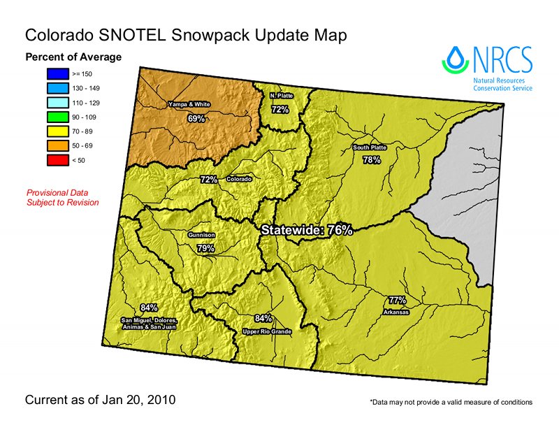
As of Thursday morning, the snowpack in the South Platte River Basin, which includes the Poudre River watershed, is 23 percent below normal, according to snowpack data compiled by the Natural Resources Conservation Service’s National Water and Climate Center. A year ago, the basin’s overall snowpack was only 6 percent below average. The snowpack below Cameron Pass at Joe Wright Reservoir is 79 percent of average, down from 105 percent of average a year ago.
Statewide, the snowpack is well below normal as well. The Yampa River Basin is down to 69 percent of normal. The Upper Colorado River Basin and the Laramie and North Platte river basins are both 72 percent of normal, while the Gunnison River Basin today sits at 80 percent of normal. The Gunnison’s snowpack a year ago was 110 percent of normal.
More coverage from the Fort Collins Coloradoan (Bobby Magill):
“What it means is, we’re probably a little better than halfway to building up our total peak (in snowpack),” said Chris Pacheco, assistant snow survey supervisor at the NRCS in Lakewood. “Between now and April, we’d have to get 130 percent of average snowfall to reach the average peak.”[…]
The snow is dry, too, with its water content nearly 3 inches below average at Cameron Pass and 76 percent of average statewide. “Seventy-six percent of average is pretty low,” Pacheco said, adding that the NRCS forecasts that there is a 10 percent probability the snowpack will return to average levels by the end of the snow season.
More coverage from the Grand Junction Daily Sentinel (Dennis Webb):
“We’re right about halfway through the winter accumulation season right now,” [Mike Gillespie, snow survey supervisor in Colorado for the Natural Resources Conservation Service] said. “It’s not really too early, I don’t think, to be a little concerned. We’re starting off on a deficit right now.” One question is whether this year’s El Niño weather pattern will bring much relief to the state. Usually, that weather pattern benefits the southwest corner the most, he said. This week, a storm has been hitting that region hard, with the Silverton Mountain ski area reporting 17 inches of snowfall in a 24-hour period, and Wolf Creek Ski Area saying Thursday the storm had brought 29 inches, with a lot more snow still in the forecast. But Dave Merritt, a board member of the Colorado River Water Conservation District in Glenwood Springs, said he saw no new snow while driving Interstate 70 east to Denver on Thursday.
More coverage from The Aspen Times (Scott Condon):
Data collected at the Skico’s snow station near Cloud 9 Restaurant at Aspen Highlands showed there were 185 millimeters of water content in the snowpack, Burkley said Thursday morning. The median for this time of winter is 258 millimeters. The lowest season-to-date was 111 millimeters back in 2000. As of Thursday morning, this season ranked in the 20th percentile for snowfall over the past 30 years, according to Burkley. In other words, only six seasons have been drier since 1980. Three of them came between 1999 and 2001, he said.
More coverage from The Pueblo Chieftain (Matt Hildner):
A storm system that could dump up to 4 feet of snow in the eastern San Juan Mountains hit Thursday afternoon and was expected to sit over the area through late Friday…
Foothills communities such as Creede and South Fork are forecasted to get between 8 and 17 inches of snow. Between 6 inches to a foot of snow are expected to fall on the Sangre de Cristo Mountains, including Poncha and La Veta passes…
Thursday’s storm had dropped 5 inches of snow at Wolf Creek Ski Area by 2 p.m. The snowfall also led to the implementation of chain laws on Colorado 17 over Cumbres and La Managa passes. By 6 p.m., 4 inches of snow had fallen at Antonito, while an inch had fallen in Monte Vista, according to weather service spotters.