Governor Ritter chooses family over dismal budget, weak economy, water supply infrastructure needs, etc.

A picture named billrittergulchie2006

From the Associated Press (Judith Kohler) via ABCNews.com:

Drilling boomed in western Colorado, home to some of the country’s largest deer and elk herds, greater sage grouse and cutthroat trout — and a tourism and hunting industry worth hundreds of millions of dollars.

Ritter courted hunters and anglers when he ran for governor in 2006. He responded to concerns about the impacts of development by backing legislation that revamped the Colorado Oil and Gas Conservation Commission. Now, more members on the regulatory body must come from outside the industry, addressing criticism that the panel was stacked in the industry’s favor.

More Colorado water coverage here.

The National Environmental Policy Act turns 40

A picture named effluent.jpg

From The Durango Herald (Megan Graham):

President Richard Nixon signed NEPA into law on Jan. 1, 1970, putting into place the protocol by which projects and processes that could impact the environment would be evaluated and mitigated to manage those impacts. It was nothing short of groundbreaking and has provided the policy and legal framework for many successes the conservation community has celebrated over the last four decades.

NEPA’s purpose is flush with common sense: “To declare a national policy which will encourage productive and enjoyable harmony between man and his environment; to promote efforts which will prevent or eliminate damage to the environment and biosphere and stimulate the health and welfare of man; to enrich the understanding of the ecological systems and natural resources important to the Nation; and to establish a Council on Environmental Quality.”

That relatively simple purpose translates into a methodical series of steps that federal agencies must take to consider the full effect of any proposed action and the range of alternatives possible for that action. It is dry, procedural and detail-intensive, but its premise – that development does not necessarily equal progress – is profound, as have been NEPA’s results.

Republican River Basin: Colorado State Attorney General’s office steps in to force Republican River compliance arbitrator decision

A picture named republicanriverbasin.jpg

From The Yuma Pioneer (Tony Rayl):

Due to delays in Colorado, Kansas and Nebraska choosing an arbitrator, and additional delays by Nebraska insisting on an in-person interview with the finalists before they could agree on an arbitrator, Peter Ampe of the Colorado Attorney General’s Office, invoked section VII.C.2 of the Final Settlement Stipulation and requested CDR Associates of Boulder, Colorado, to select the arbitrator. Three CDR staff members reviewed the resumes, two that have worked on Republican River issues, and one independent reviewer. All concurred with a recommendation that Martha Pagel should be the arbitrator for Republican River Compact issues. Her experience with groundwater, as former Director of the Oregon Water Resources Department and background as a lawyer and making decisions on technical groundwater issues, qualify her for the position.

Colorado State Engineer Dick Wolfe told the Pioneer earlier this week that the states are close to getting Pagel under contract. Once on the job, she and the states will determine any appropriate modifications to the schedule. “At this time, we do not know the extent the timeline will be affected,” Wolfe said. According to a bio of Pagel found at the web site of the lawfirm Schwabe, Williamson & Wyatt, she is a recognized regional leader in water law and natural resources. She has been named by her peers as an Oregon “Super Lawyer” based on her experience and accomplishments. She is a frequent speaker on water law, natural resources, watershed management and alternative dispute resolution. She also has written several articles about water laws and rights.

Meanwhile…

The Republican River Water Conservation District is holding its regular quarterly meeting Thursday, January 14, at the Burlington Community and Education Center, 340 S. 14th. It is set for 10 a.m. to 4 p.m. Among the agenda items is discussing and receiving input from the public regarding construction of the compact compliance pipeline. The district is seeking input on whether or not to proceed with construction before the pipeline actually receives approval from the Republican River Compact Administration. Kansas and Nebraska each have issues that have been difficult to resolve. Regular public comment is set for 1 p.m. The board is scheduled to vote on authorizing change of use for North Fork surface water rights under lease from the Yuma County Water Authority. It also will discuss applying for change of use on water rights purchased on the South Fork, among other items. Assistant State Conservationist Tim Carney will make a presentation. For further information, please contact RRWCD General Manager Stan Murphy at 332-3553, e-mail at rrwcd@centurytel.net, or visit the web site at http://www.republicanriver.com.

More Republican River Basin coverage here and here.

Montrose scores $75,000 grant from GOCo for ‘Montrose Comprehensive Uncompahgre Riverway Master Plan’

A picture named uncompahgreriver.jpg

From The Telluride Watch (Beverly Corbell):

The grant, written by City Park Planner and Project Manager Dennis Erickson, will be used to develop “the first-ever Montrose Comprehensive Uncompahgre Riverway Master Plan,” according to the city’s website.

With a plan in place, the city will have “a valuable tool for directing its long-term efforts toward maintaining the beauty of the Uncompahgre River for generations to come.” But there’s more than beauty to be preserved, Erickson said, and the plan could look at possible development of water sports like kayaking. “It will be multi-objective with numerous interests and stakeholders taking part,” he said. “We want different perspectives on what should happen with the river.” The Montrose City Council must first adopt a resolution to sign the GOCO grant, which Erickson said he hopes will happen at the Jan. 7 meeting.

More Uncompahgre River watershed coverage here and here.

Fountain Creek: CWQCC weighing removing impairment status on two sections

A picture named fountaincreek.jpg

From The Pueblo Chieftain (Chris Woodka):

The Colorado Water Quality Control Commission will consider recommendations by the state Water Quality Control Division to remove impairment status on two sections of Fountain Creek for selenium and arsenic. The division also is recommending E. coli impairment designation only during summer months.

“We’re convinced that if the commission simply accepts the division’s proposed changes in the impairment rules – the likely path of least resistance for the commission – our collective efforts to achieve clean water in Fountain Creek will suffer a serious setback,” said Ross Vincent, of the Sangre de Cristo chapter of the Sierra Club. The Sierra Club and the Rocky Mountain Environmental Labor Coalition filed a joint pre-hearing statement Tuesday asking the commission not to remove the designations.

A similar statement opposing the changes was filed Wednesday by Pueblo District Attorney Bill Thiebaut, supporting the environmental group’s position and adding that there is no “statement of basis” for removing the stricter designations from Fountain Creek.

The impairment designation creates a higher standard for discharging treated effluent into Fountain Creek under Section 303(d) of the federal Clean Water Act. Currently, sewer plants in El Paso County are permitted to discharge nearly 100 million gallons per day into the Fountain Creek watershed – a number that could increase by 60 percent in the next 40 years.

More Fountain Creek coverage here and here.

Breckenridge: Moffat Collection System Project hearing today

A picture named fraservalleycollection.jpg

From the Summit Daily News:

An open house will precede the public hearing, from 4-6 p.m., to allow the public to review information and ask questions of resource specialists concerning the Draft Environmental Impact Statement that has been prepared on the project. The public hearing begins at 6 p.m. and include a brief formal presentation of the project, followed by the opportunity for individuals to testify. The open house is at the Beaver Run Conference Center, Peak 17 Conference Room, 620 Village Road (at the base of Peak 9).

More Moffat Collection System coverage here.

Snowpack news

A picture named nrcssnowpack01052010

From The Aspen Times:

The snowpack ranged from a low of just 72 percent of average in the northwest part of the state to 97 percent in the southwest, according to the conservation service, which is part of the U.S. Department of Agriculture. The Aspen area’s snowpack mirrored that of the state overall, at 85 percent of average. The conservation service measures snow at seven stations in the Roaring Fork watershed. Its data shows the snowpack is lowest in the Fryingpan drainage and highest in the Crystal drainage. The snowpack is just 35 percent of average at Nast Lake in the Fryingpan Valley; 62 percent at the Kiln site; and 95 percent up higher in elevation at Ivanhoe. In the Crystal drainage, the snowpack was 84 percent of average at North Lost Trail near Marble; 88 percent of average at McClure Pass; and 99 percent at Schofield Pass…

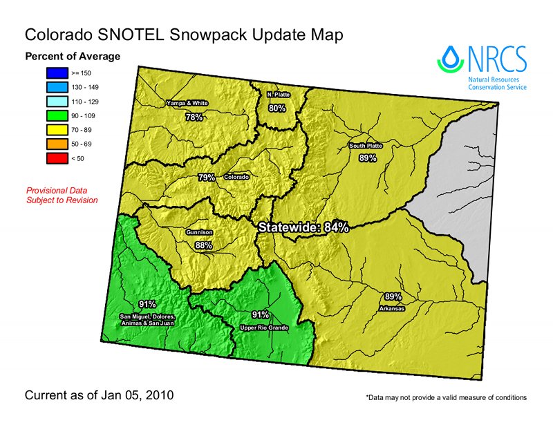
The statewide average is the lowest its been on Jan. 1 since 2003, according to Allen Green, state conservationist with the conservation service. And the snowpack lags well behind the last two years, when powder piled high during storm after storm in December both winters. The statewide snowpack is only 72 percent of what it was last year at this time.

From the Craig Daily Press (Tom Ross):

The federal Natural Re s ource Conservation Service reported Wednesday that the snow in the mountains flanking the Yampa and White river basins contains 78 percent of the typical water content for this point in the winter. The snowpack measuring station at 9,400 feet elevation on the west side of Rabbit Ears Pass stands at 61 percent of the average 10.7 inches of water for this date. North of Steamboat, at 10,500 feet, the 17 inches of water stored in the snowpack is 78 percent of average. Weather observer Art Judson, who has a weather station on Buffalo Pass, said the snow depth there Tuesday was 81 inches.

From the Summit Daily News (Julie Sutor):

Snowpack in the Blue River Basin, home to Breckenridge and Silverthorne, registered 76 percent of average, according to the latest survey by the USDA Natural Resources Conservation Service, conducted Jan. 1. Hoosier pass and Loveland Pass are at 87 percent and 68 percent of average, respectively…

“We’re in an El Niño year this year, which is typically dry in mid-winter,” said Mike Gillespie, snow survey supervisor with the Conservation Service. “There’s hope we could see some relief during the later spring months.”[…]

According to Gillespie, the state as a whole has about a 20 percent chance of being above average by then. Last winter, Colorado’s statewide maximum total snowpack was 109 percent of average…

Current reservoir storage throughout the state is slightly above average, with the exception of southwestern Colorado, where water storage levels are below normal volumes.

From The Durango Herald:

Southwest Colorado’s snowpack is almost on the mark at 97 percent of its historical average…

Local snow levels – in the San Miguel, Animas, Dolores and San Juan River basins – were the highest in the state…

December 2009 snowfall in Durango was more than twice its 18-year average, with the town receiving 24.05 inches. Durango’s average December snowfall, as established by the Western Regional Climate Center, is 11.86 inches. Joe Ramey of the National Weather Service’s Grand Junction office said that we are in an El Niño year, causing snowier conditions in the southwest mountains and drier conditions in the northwest. Most of the service’s automated snow-measuring sites place snowfall at below average, with Red Mountain Pass at 81 percent of average, the Upper Arkansas basin at 88 percent of average, and the upper Rio Grande basin at 90 percent of average. In addition, snowfall on the Wolf Creek Pass summit has received 105 percent of average…

“Given our current conditions, we need to receive about 110 percent of average snowfall from now until mid-April to reach our average maximum totals,” said Allen Green, with the conservation office. The office is predicting below-average runoff across most of the state, with the lowest levels occurring in northwestern Colorado.

Statewide reservoir storage levels are slightly above average at 102 percent average storage levels, though not in Southwest Colorado. Reservoirs in this region rank dead last in the state with reservoir levels at 89 percent of average. As of Wednesday, Vallecito and Lemon Reservoir levels were at 78 percent of average and 48 percent of average, respectively.

From The Mountain Mail:

In the Arkansas River Basin, snowpack is 89 percent of average. “While this year’s snowpack is both below average and well below that of last year, it’s still too early to be overly concerned about short water supplies. We still have 60 percent of the winter snowpack accumulation season ahead of us,” state snow survey supervisor Mike Gillespie said…

Gillespie said preliminary forecasts predict slightly below average water supply, or between 75 and 90 percent of average. The information affects irrigators and Colorado water users, in addition to those in downstream states. “Everyone is affected in one way or another. Municipalities use the information to gauge how much water they’ll have. Reservoir operators need to know how much inflow they can anticipate so they can manage operations and maximize storage volumes in the spring…

Reported data shows Apishapa, in the southern Sangre de Cristo range, as the only area in the Arkansas River Basin with above average snowpack, at 106 percent of average. Whiskey Creek, near Stonewall, reported the lowest percent of average, at 63 percent. At Porphyry Creek, near Monarch Pass, snowpack measured 99 percent of average, with 31 inches of snow. South Colony, near Westcliffe, measured 95 percent of average snowpack and 33 inches of snow depth. Brumley reported 86 percent of average snowpack and Fremont Pass reported 84 percent of average.

Buena Vista: DNR/BLM Geothermal open house January 14

A picture named geothermalenergy.jpg

Here’s the agenda from the Ark Valley Voice.

More geothermal coverage here and here.