The new analysis, to be started this year and completed in 2015, will reassess the Kansas Aqueduct, one of four projects evaluated 31 years ago to provide water to high plains farms in Kansas and reduce the draw on the Ogallala aquifer, the region’s primary source of water for irrigation. None of the water transport projects that were evaluated in the 1982 study were built.
But one project, the Kansas Aqueduct, which would draw water from a turn in the Missouri River about 145 kilometers (90 miles) upstream of Kansas City, and drop it into a reservoir roughly 600 kilometers (375 miles) away in western Kansas, attracted significant attention.
The cost of the new $US 300,000 study will be shared equally by the state and the federal government, said Mark Rude, executive director of the Southwest Kansas Groundwater Management District. Rude added that the region’s strong farm economy and the urgency of extending the Ogallala’s life as a source of water to agriculture make this a useful period to reconsider the Kansas Aqueduct.
“The Kansas Aqueduct Project must be pursued while production income, property values and the economic system are in place to support the project,” Rude wrote in a June letter to state water officials…
Because of high plains geology and climate, water percolates into the aquifer each year in inches; but in order to sustain a thriving grain-and-cattle industry, water is pumped out in feet.
The farmers and cattlemen in Rude’s district in southwest Kansas know this fact all too well. Rude told Circle of Blue that current rates of groundwater extraction – mining, really – are about nine percent sustainable. In other words, the amount of water pumped out of that part of the aquifer would have to be cut by 90 percent to find a balance. Such a reduction would decimate the region’s towns.
Over the years, all that water has created a more prosperous life on the plains than the early pioneers could ever have imagined. The economic structure, formidable for the time being, collapses without water.
“Everything we need is here already,” Rude says, talking about the grain elevators, equipment dealers and related agricultural infrastructure in western Kansas. “But new investment needs water-confidence. How do we provide that when we are cutting water use? It’s ideal to have both cuts and new supplies and manage the aquifer more like a reservoir.”
Farmers in northwest Kansas, in Sheridan County, have agreed to self-imposed restrictions on the amount of water they draw from the Ogallala. It is an experiment that has yet to catch on elsewhere in the state.
Economics are foremost in Rude’s mind because the aqueduct would be a whopper of a project, at least double the estimated $US 3.6 billion price tag three decades ago, and comparable in scale to massive water diversions like the 540-kilometer (360-mile) Central Arizona Project that was approved before the Carter administration and built mostly with federal money.
Rude scoffs at the suggestion that a Kansas aqueduct is a relic of a by-gone age. “I’m comfortable if you say it’s a Roman project in the 21st century,” he said, recalling the channels that satiated Caesar’s capital more than two millennia ago. “The aquifer is a question that has to be dealt with.”
Storm pattern over Colorado September 2013 — Graphic/NWS via USA Today
Here’s the release from Colorado State University (Tony Phifer):
Scientists can’t predict when disasters like the massive Colorado flooding in September or recent wildfires will occur, but a new study hopes to assess risks that could alert officials of the potential for disasters in specific areas. The $4.9 million, five-year study, sponsored by the National Science Foundation and the Department of Energy, will be led by Dan Cooley, associate professor in the Department of Statistics at Colorado State University. He will work with scientists from the University of California-Berkeley, the University of North Carolina-Chapel Hill, and Lawrence Berkeley National Labs.
Cooley hopes to use statistical models to help determine the risk of extreme events like flooding, wildfires and droughts in certain areas. He said data will be mined from satellite images, climate models and other sources to assess the risk of natural disasters.
“These events take place because of the right combination of events, such as heat, wind and lack of moisture,” he said, referring to the large number of highly destructive Colorado wildfires over the past two years. “This is all about risk assessment, not weather prediction. We hope to improve, from a statistical point of view, our ability to determine risks associated with extreme events.”
Cooley said Colorado’s recent floods, which killed eight and caused hundreds of millions of dollars in damage across the state, were far different from the 1976 Big Thompson Flood near Loveland, which claimed 143 lives and caused more than $30 million in damage. The recent floods were spread over several days and an area that included hundreds of square miles. The Big Thompson Flood was contained to a relatively small area.
“When assessing risks we want to look at both types of events and create a model that approximately tracks the true risk of each type of event occurring,” he said. “The recent floods in Colorado were quite different from anything on record because they were so widespread. The Big Thompson flood and the 1997 Spring Creek flood in Fort Collins flood (that killed five and severely damaged the CSU campus) were much more intense, concentrated events. The difference shows the need to understand the spatial and temporal aspects of these events.”
Complicating the process, Cooley said, is our ever-changing climate, which complicates the way past data is analyzed. As a result, “100-year events” may occur more or less frequently than researchers have come to believe.
“We will develop probability-based measures of risk that take account of the fact that extreme weather events cannot be predicted with certainty,” he said. “Was the recent flooding in Boulder caused by climate change? That can’t be answered with a simple ‘yes’ or ‘no,’ but we can assess the probability of that event taking place in a changed climate.”
Another aspect of the study will be working with social scientists to determine the potential impact of extreme weather events on people across a broad range of socio-economic circumstances.
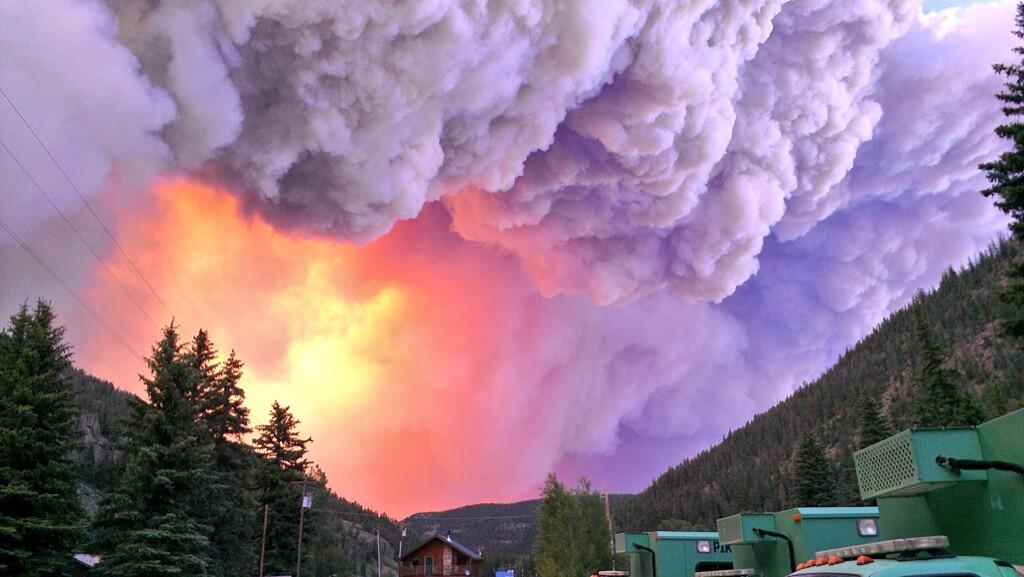
West Fork Fire June 20, 2013 photo from the Pike Hot Shots via Wildfire Today
Click here to read the abstract and download the report. Here’s the abstract (Kristine L. Verdin/Jean A. Dupree/Michael R. Stevens):
This report presents a preliminary emergency assessment of the debris-flow hazards from drainage basins burned by the 2013 West Fork Fire Complex near South Fork in southwestern Colorado. Empirical models derived from statistical evaluation of data collected from recently burned basins throughout the intermountain western United States were used to estimate the probability of debris-flow occurrence, potential volume of debris flows, and the combined debris-flow hazard ranking along the drainage network within and just downstream from the burned area, and to estimate the same for 54 drainage basins of interest within the perimeter of the burned area. Input data for the debris-flow models included topographic variables, soil characteristics, burn severity, and rainfall totals and intensities for a (1) 2-year-recurrence, 1-hour-duration rainfall, referred to as a 2-year storm; (2) 10-year-recurrence, 1-hour-duration rainfall, referred to as a 10-year storm; and (3) 25-year-recurrence, 1-hour-duration rainfall, referred to as a 25-year storm.
Estimated debris-flow probabilities at the pour points of the 54 drainage basins of interest ranged from less than 1 to 65 percent in response to the 2-year storm; from 1 to 77 percent in response to the 10-year storm; and from 1 to 83 percent in response to the 25-year storm. Twelve of the 54 drainage basins of interest have a 30-percent probability or greater of producing a debris flow in response to the 25-year storm. Estimated debris-flow volumes for all rainfalls modeled range from a low of 2,400 cubic meters to a high of greater than 100,000 cubic meters. Estimated debris-flow volumes increase with basin size and distance along the drainage network, but some smaller drainages also were predicted to produce substantial debris flows. One of the 54 drainage basins of interest had the highest combined hazard ranking, while 9 other basins had the second highest combined hazard ranking. Of these 10 basins with the 2 highest combined hazard rankings, 7 basins had predicted debris-flow volumes exceeding 100,000 cubic meters, while 3 had predicted probabilities of debris flows exceeding 60 percent. The 10 basins with high combined hazard ranking include 3 tributaries in the headwaters of Trout Creek, four tributaries to the West Fork San Juan River, Hope Creek draining toward a county road on the eastern edge of the burn, Lake Fork draining to U.S. Highway 160, and Leopard Creek on the northern edge of the burn. The probabilities and volumes for the modeled storms indicate a potential for debris-flow impacts on structures, reservoirs, roads, bridges, and culverts located within and immediately downstream from the burned area. U.S. Highway 160, on the eastern edge of the burn area, also is susceptible to impacts from debris flows.
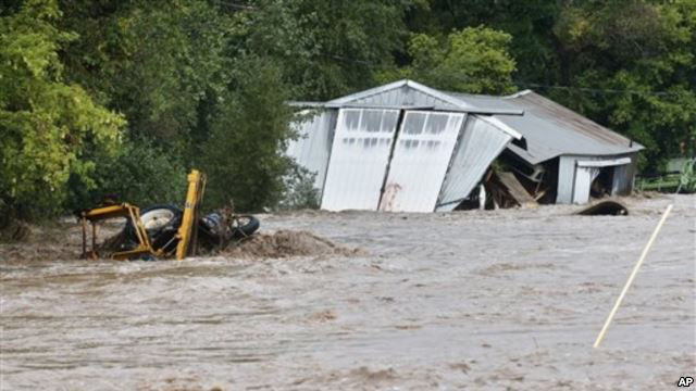
G. Robert Brakenridge has spent his career researching floods. But a lifetime’s worth of knowledge didn’t make it any easier when his own life was upended by rushing water.
Brakenridge, the director of the Dartmouth Flood Observatory and a senior scientist at the University of Colorado, Boulder, was among the hundreds of people cut off from the world in Lyons, Colo., in September, when days of heavy rain unleashed torrential floods along the Colorado foothills.
“You could hardly see the bridges anymore,” Brakenridge told LiveScience. “They were almost invisible inside the river.”[…]
Lyons remains unlivable. Town officials now say utilities may be restored by Thanksgiving. Many of the older homes in the town’s downtown area were destroyed, and a popular park along the St. Vrain was wiped away.
“The river just tore the guts out of parts of the center of the town,” Brakenridge said.
The Colorado Water Conservation Board this week increased to $40 million the funds available for low-interest loans to help irrigators start repairing flood-damaged systems in Northern Colorado.
The amount represents an increase from the $15 million it had designated earlier this month.
The CWCB also has approved the first round of loans, for a total of $12 million. The loans carry a 30-year term with no interest and no payments the first three years.
The loans were distributed to 10 irrigation and ditch companies for emergency repairs of diversion structures and ditch systems, and ranged in amount from $202,000 to the Boulder and Larimer County Irrigating and Manufacturing Ditch Company to $3.3 million for the Left Hand Ditch Co.
“These repairs are a critical part of recovery from the September floods and the CWCB will continue providing loans and taking other proactive steps to get irrigators, farmers and water suppliers back on their feet,” said CWCB Director James Eklund.
Tens of millions more dollars have been freed up to help water providers repair the many systems damaged in last month’s historic flooding. The Colorado Water Conservation Board this week increased its available funds for low-interest loans to $40 million — up from the $15 million it originally had designated.
After announcing the $15 million for loans earlier this month, the CWCB within days received applications for about $12 million in loans from water providers. CWCB officials had announced the initial $15 million in loans at the South Platte Roundtable meeting on Oct. 8 and, at the time, said they were hoping to make available more dollars for loans, predicting a huge influx of requests. This week, they made that happen.
During last month’s flooding in northeast Colorado, nearly all agricultural irrigation ditches, reservoir companies and other water providers in the region experienced damage along their systems — ditches, dykes, gravel pits, canals, head gates and other diversion structures along the rivers that were washed out or destroyed and now need to be repaired, or even rebuilt. More than a month later, water providers still are assessing the widespread damage, but some are reporting damages have added up into the hundreds of thousands of dollars, even millions of dollars.
Officials with the Central Colorado Water Conservancy District in Greeley have reported their district alone has about $1 million in needed repairs.
State and local water officials have stressed that, with the loans, they’re wanting to free up dollars quickly so water providers can get started on the repairs, which need to be done before next spring, when water providers will need to capture mountain snowmelt in their reservoirs and then deliver water to farmers starting to grow crops.
In addition to increasing the amount of loan dollars available, the CWCB this week also approved the $12 million in loan applications it had already received. Those loans were distributed to 10 irrigation and ditch companies for emergency repairs of diversion structures and ditch systems, and ranged in amount from $202,000 to the Boulder and Larimer County Irrigating and Manufacturing Ditch Company to $3.3 million for the Left Hand Ditch Company.
Other loans approved as part of the $12 million package included the Highland Ditch Company ($2 million), Rough and Ready Irrigating Ditch Company ($1.8 million), Oligarchy Irrigation Company ($1.3 million), Big Thompson and Platte River Ditch Company ($800,000), Ish Reservoir Company ($207,000), Consolidated Home Supply Ditch and Reservoir Company ($1.6 million), Church Ditch Water Authority ($606,000) and the North Poudre Irrigation Company ($482,000).
With its emergency loan program, the CWCB is offering 30-year loans, which for three years will carry zero percent interest with no payments required. The following 27 years of the loan payments will include interest based on current rates. The CWCB’s loans typically require a 10 percent down payment but that’s not required for the $40 million the CWCB recently freed up.
In addition to the $40 million in loans, Colorado water officials have put up another $1.8 million in grants to help water providers.
Officials with the CWCB — an organization created about 75 years ago to provide policy direction on water issues in the state — is providing $1.5 million of $1.8 million available in grants.
The South Platte and Denver Metro roundtables — each consisting of experts from those respective basins who meet every other month, sometimes more frequently, to discuss water issues in the region — agreed at their meetings this month to each contribute another $150,000 to the grant pot, bringing the total in grant dollars available to $1.8 million.
The Northern Colorado Water Conservancy District in Berthoud is serving as the “financial agent” for the grants.Eric Wilkinson, general manger at Northern Water, explained that the grants distributed wouldn’t exceed $25,000, although each water provider could receive up to five grants. He further noted that, with $25,000 being the maximum, the grants ideally would go toward technical assistance, such as consulting with engineers and other experts, rather than going toward the actual construction work.
…said board director James Eklund in a statement. “We thank the board for its far-sighted and quick action in directing these loans to these important projects.”[…]
Among those getting loans were several ditch companies in Boulder County, with Left Hand Ditch Company receiving $3.3 million, Rough and Ready Irrigating Ditch Company in Longmont receiving $1.8 million and Oligarchy Irrigation Company receiving $1.3 million.
Colorado Springs City Council and Mayor Steve Bach continue to wrangle over how stormwater funding will be handled. Council president Keith King on Friday said council does not want to expand city government, after Bach chastised council earlier in the week.
Colorado Springs Utilities committed to mitigation of floodwater on Fountain Creek in 2009 as part of its conditions when it obtained a 1041 land-use permit from Pueblo County for Southern Delivery System.
“We’d like to clarify that council is not endorsing the creation of a physical department nor do we have plans to expand city government. We are advocating for the creation of a virtual department, or more accurately, a stormwater appropriations or dedicated funding source,” King said. “This virtual department is strictly an accounting mechanism to inform citizens of how much revenue we are allocating to stormwater and ensures that the funds are solely dedicated to stormwater.”
Council has proposed using $2 million from this year’s fund balance to begin work immediately.
Earlier this week, Bach told council he does not favor creating a new department after the council sent him a letter Oct. 14 saying it would propose a stormwater appropriation department. A “virtual” department would assure the public that stormwater needs are being considered, King said.
“We must commit money from of our general fund for operation and maintenance. We must show our citizens we are serious about addressing the stormwater drainage issues. We must show our friends in Pueblo that we are resolute about how much we are spending,” King said. “Most importantly, we must make sure, as council, that we can audit the numbers and prove our expenditures to the citizens.”
Bach claims $25 million for stormwater, including wildfire mitigation, is included in his budget proposal for next year. The mayor wants to extend current bonds to pay for $100 million in the most critical stormwater needs over five years. Colorado Springs stormwater needs are estimated at about $535 million.
Council is working with an El Paso County stormwater task force to develop a sustainable funding source for projects, as well as a regional approach.
Thursday, a couple dozen residents showed up to the first “Stormwater Solutions Town Hall” at the Conservation and Environment Center. Officials sat back and let residents pick through possible solutions to come up with what they believe is most feasible.
“The solution is a regional approach,” said homeowner Sharon Owen.
A regional approach and a willingness to invest in stormwater infrastructure were shared by those in attendance.
“This is what happens when you don’t invest,” said homeowner Bruce Fogarty. “It’s going to be expensive but it’s something that absolutely needs to be done.”
After nearly an hour of residents brainstorming and presenting their ideas, task force members say they plan on taking the ideas brought forward here and at two more town halls to come up with what they hope is a final solution.
“If you don’t plan it, if you don’t do it right you’re wasting your time and energy,” [El Paso County Commission Chairman Dennis Hisey] said.
“We don’t want to grow government,” Bach said in his remarks to City Council this week.
Bach was reacting to a letter the nine council members sent him earlier this month outlining their plan to create a Stormwater Department and take $2 million from the city’s 2013 rainy day fund to start it.
The idea, said council president Keith King, is to get moving immediately on stormwater projects. He said it would show residents that the city is spending money from its general fund on stormwater projects. And it could be viewed as a good faith commitment should the city council ask residents to approve a fee or tax to pay for stormwater projects, he said.
Bach said his plan to pay for stormwater projects does not require a new tax or fee.
“The prior city council imposed a fee,” Bach said. “It was well meaning, but it didn’t resonate well.”
A short-lived Stormwater Enterprise and its fee was rescinded four years ago and left the city without a dedicated funding source to pay for millions in stormwater and drainage needs, which has been the focus of nearly two years of meetings and discussions. Colorado Springs sits in the northern section of the Fountain Creek Watershed – a 927-square mile watershed that includes three counties and eight municipalities. Legally, the city is responsible to keep the community safe and move stormwater through the city to avoid flooding, keep a safe environment and ensure water quality.
Bach wants residents to extend the voter-approved Springs Community Improvement Program, which was the sale of $88 million in municipal bonds and paid for 29 capital improvement projects. The projects were completed in 2004 and the debt, paid for from the general fund, is scheduled to be paid off in 2016. If voters extended the bond program, the city could spend $175 million on projects in five years and pay back the debt in 20.
The money also could be spent on other city capital improvement projects that have been on hold, Bach said. Road improvement, bridge repair and building repair and renovations have gone untouched for years. Bach’s idea about renewing the SCIP bond program would spend $20 million a year for five years on stormwater projects, $11.5 million on roads and bridges and set aside $1 million a year for city park improvement, he said. And instead of a new city department, all of the projects would be handled by the city’s public works department.
But City Council said the mayor’s plan does not address regional stormwater concerns. A regional stormwater task force, for nearly two years, has described stormwater issues as regional saying that if money is spent north of the city, in the county limits, it benefits entities downstream. The taskforce envisioned a regional tax or fee that would be a permanent source of money for the stormwater and drainage projects, which by some estimates is nearly $700 million. This approach would be a pay-as-you-go method and a fee or tax also would cover the estimated $11 million in ongoing maintenance needs to keep the existing stormwater channels, drainage ponds and other systems in good shape.
“One of the things we need to look at is the entire watershed, from the top of El Paso County to Pueblo,” King said.
From the Colorado Springs Independent (Pam Zubeck):
The dust-up between City Council and Mayor Steve Bach over stormwater took another turn today when Council President Keith King issued a statement disputing remarks Bach has made in recent days.
As reported on the Independent’s blog on Oct. 16, Council issued a letter to Bach seeking more detail on the 2014 budget and declaring it wanted to create a stormwater department.