
Day: October 3, 2013
51st State Initiative: ‘First and foremost, water rights are private property’ — Sean Conway
 From The Greeley Gazette (Sean Conway):
Since discussion of creating a 51st State began, the most asked question I have had is how will the existing water rights our farmers and communities currently own be impacted?
First and foremost, water rights are private property. And like other private property – your home, car or land that you own – they cannot be taken away because you live in another state. Many water rights throughout Colorado are currently owned by individuals and entities who do not reside in the state of Colorado. Under the constitution, any private property that might be attempted to be seized would be called a “taking” and has been deemed by the U.S. Supreme Court as unconstitutional.
Second, the U.S. Supreme Court in 1982, in the landmark case of Nebraska v. Douglas, ruled no state may impose severe withdrawal, impede, divert or keep water from flowing into another state. This case, between the State of Colorado and Nebraska, is important, because this ruling would have precedence over the Colorado State Constitution and existing State law. This ruling protects all current water right holders.
Third, existing Water Compacts between the state of Colorado and the states of Nebraska and Kansas and other states must continue to be honored under federal law. This means that the water that flows currently from the Poudre River, South Platte and St. Vrain, along with other tributaries, must continue to flow as is, uninterrupted, toward those states to meet those federal compacts.
Fourth, the largest supplier of water to Weld, Morgan, Logan and Sedgwick Counties is the Big Thompson Water Project. This project, which is operated by the Northern Colorado Water Conservancy District (NCWCD), provides 220,000 acre feet annually to northeastern Colorado and is a federal project permitted by the Army Corp of Engineers. This permit would remain and continue to operate as usual. In addition, the only thing needed to protect the current boundaries of the district in the new state would be for those boundaries to be recognized in the new state’s constitution; something that would be almost certainly the first thing the new state constitution would include.
In discussions with several water attorneys and water experts about the new state, the one common phrase that was frequently stated to me about existing water rights and protection for water right holders was it is “very attainable.” Protection for the existing counties in the NCWCD and working out an agreement with Colorado and other current compact states are very “doable” and can be accomplished.
Finally, benefits overlooked by those looking at this issue in a parochial manner include the ability of a new state to enter into new compacts with other states and the ability of a new state to address the issues of needed water storage projects as well as the “buy and dry” issues that have seen tens of thousands of acres of productive farm land along the South Platte be transferred to metro Denver communities over the last three decades.
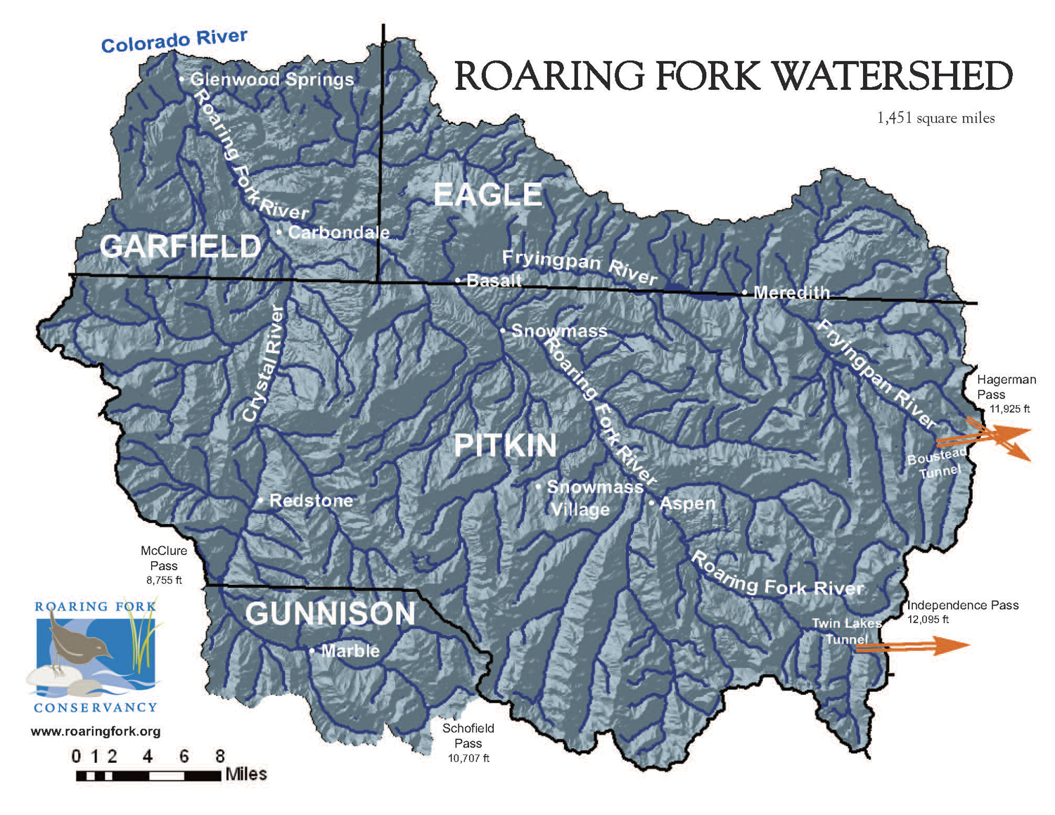
Another item which might escape naysayers is that a new state could include several western slope counties including Grand, Garfield, and Mesa. All head water counties for the Colorado River and the origin for much of the water we currently use in Northern Colorado. If these counties were to be part of the new state, our very valuable water rights would even be more protected.
To conclude, any new state would protect current water right holders. The actions needed to protect those water rights have been identified and certainly will be acted on by the new state.
More 51st State Initiative coverage here.
NWS Pueblo: September Climate Review and October Preview
From the National Weather Service Pueblo office:
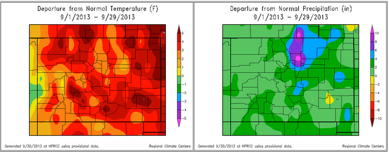
September of 2013 started out very warm and dry across Colorado, as a large upper level ridge of high pressure persisted across the state. A weather system then moved into the Great Basin Region bringing a prolonged period of moist southerly flow aloft to the region from September 9th through the 15th. This moist southerly flow aloft, combined with moist low level upslope flow behind passing cold fronts across eastern Colorado, brought extreme rainfall to region, especially to portions of the Front Range, where pockets of 12 to 17 inches of rain were recorded. Unfortunately, this historic rainfall also caused deadly and destructive flooding across the state, with priliminary damage estimates of nearly 2 billion dollars to residental properties and infrastructure across the state at this time. September of 2013 then ended nearly the same as it started, with generally warm and dry conditions across the state. The following graphics depict departures from normal for both temperatures and precipitation experienced across the state over the past month.
Colorado Springs recorded 4.80 inches of rainfall over the past month of September. This is 3.61 inches above normal and makes September of 2013 the third wettest September on record, behind the 5.91 inches and the 4.97 inches recorded in September of 2011 and 2008, respectively. Colorado Springs has received other noteable amounts of precipitation over the past few months, with a combined 10.52 inches of rain recorded over the two past months. This makes August and September of 2013 the wettest on record, surpassing the 10.22 inches of precipitation recorded through August and September of 1976. Colorado Springs has also recorded a combined 15.13 inches of precipitation over the past 3 months. This makes the July through September timeframe of 2013 the wettest on record, surpassing the 12.30 inches recorded in the July through September period of 2011. In fact, the 3 month combined precipitation total of 15.13 inches is the third highest three month period precipitation total on record in Colorado Springs, just behind the 16.85 inches recorded in the June through August period of 1965, and the 15.66 inches recorded in the April through June timeframe of 1995.
As for temperature, the average September temperature in Colorado Springs was 65.5 degrees. This is 4.6 degrees above average and makes September of 2013 the third warmest on record, behind the 67.0 degrees and the 66.6 degrees recorded in September of 2010 and 1931, respectively.
Alamosa recorded 2.98 inches of rainfall over the past month of September. This is 2.07 inches above normal and makes September of 2013 the wettest September on record, surpassing the 2.62 inches recorded in September of 1938. Alamosa has also tallied a combined 5.45 inches of precipitation over the past two months, making August and September of 2013 the second wettest on record in Alamosa, just behind the 5.98 inches of precipitation recorded in the August and September period of 1993. Alamosa also recorded a combinded 6.25 inches of precipitation over the past three months, making the July through September timeframe of 2013 the third wettest on record, just behind the 6.31 inches and 6.30 inches recorded in the July through September period of 1993 and 1936, respectively. The combined 6.25 inches of precipitation recorded over the past three months in Alamosa is also the fourth highest three month period precipitation total on record in Alamosa.
As for temperature, the average September temperature in Alamosa was 57.8 degrees. This is 2.8 degrees above average and makes September of 2013 tied as the 7th warmest on record, well behind the 59.0 degrees recorded in September of 1933.
Pueblo recorded 1.27 inches of rainfall over the past month of September, which is 0.50 inches above normal. Pueblo has also recorded notable amounts of precipitation over the past two months, with a combined total in August and September of 2013 of 5.19 inches, making it the 6th wettest August and September on record.
As for temperature, the average September temperature in Pueblo was 69.6 degrees. This is 4.7 degrees above average and makes September of 2013 the 7th warmest on record, well behind the 71.0 degrees recorded in September of 1931.
Looking ahead into October, in Colorado Springs, the average high and low temperature of 68 degrees and 41 degrees on October 1st cools to 58 degrees and 31 degrees, respectively, by the end of the month, with an average monthly temperature of 49.4 degrees. Colorado Springs averages 0.82 inches of precipitation along with 2.9 inches of snow in October.
In Alamosa, the average high and low temperature of 68 degrees and 30 degrees on October 1st cools to 55 degrees and 19 degrees by the end of the month, with an average monthly temperature of 43.1 degrees. Alamosa averages 0.68 inches of precipitation and 2.1 inches of snow in October.
In Pueblo, the average high and low temperature of 75 degrees and 40 degrees on October 1st cools to 64 degrees and 29 degrees by the end of the month, with an average monthly temperature of 51.8 degrees. Pueblo averages 0.72 inches of precipitation along with 1.3 inches of snow in October.
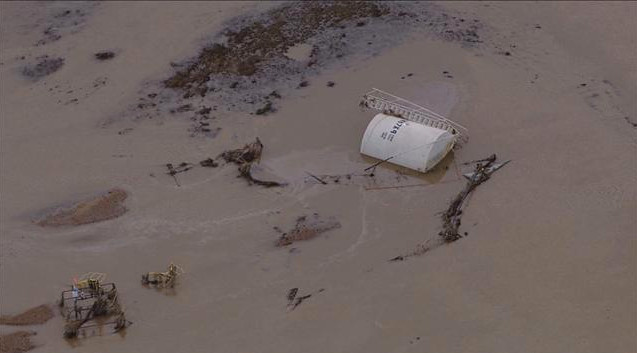
Surface streams carved new channels in some areas during the recent flooding #COflood

From The Greeley Tribune (Eric Brown):
Water officials and water providers face a rare predicament following last month’s historic flood. Discussions on whether the region’s rivers should be put back in their previous locations are now taking place after surging floodwaters cut several new paths — relocating rivers as much as three-fourths of a mile in some spots, according to reports.
A number of water providers this week expressed support to get the rivers back to their previous locations, at least in areas where their diversion structures are no longer on the banks of the rivers, and can’t draw water into reservoirs or ditches. Without moving the rivers back, those water providers would have to build new diversion structures where the river is now located, they said, which could add up into the hundreds of thousands of dollars, maybe more.
While there’s much support to get the rivers back to their previous locations, there still are questions about permitting for the river-redirecting endeavors, legal issues, and about who would pay for the projects, among others. “This issue could be complicated,” said Dick Wolfe, state engineer with the Colorado Division of Water Resources. “In the several instances where ditch companies or others had structures that were washed out or had other damage, it’s fairly clear how those repairs should be done. But in the cases where the rivers cut a whole new channel … there’s still a lot of discussions that need to be had.”
Wolfe said he and others with the state will continue working closely with local and federal officials, including the U.S. Army Corps of Engineers, which evaluates permit applications for essentially all construction activities that occur on the nation’s waters, including rivers.
“It’s certainly not an issue the state has dealt with during my professional career,” said Wolfe, who’s worked in the water business in Colorado for 27 years. “And while the floods of 1965 and 1976 caused similar problems, the federal permitting process and other things have changed so much since then … that I’m not sure we can really use those as a road map.”
Regardless of the challenges, water providers and water users say there’s limited time to fix the problem.
“It’s definitely something we need to get done … and fairly quickly, so we can be ready to capture spring runoff (snowmelt from the mountains) next year, and be ready to irrigate,” said Steve Schultz, board president for the Ish Reservoir and Ditch Co., which provides water to about 15,000 acres between Berthoud and Johnstown, and whose diversion structure along the Little Thompson River is no longer where it can divert water, after the river changed its course during the flooding.
While the rivers changed course in several locations, they didn’t separate themselves from diversion structures at all of those spots.
Still, many water providers were impacted in some way from the flooding.
A number of representatives from irrigation ditches, reservoir companies and other water officials have reported tens of thousands of dollars in damage, much more in some cases, along their systems — ditches, dykes, gravel pits, canals, head gates and other diversion structures that need repairs, or even to be rebuilt.
The irrigating season is over for farmers, who are now concentrated on harvesting their crops as soon as their fields dry. The bigger issue, they say, could be the ability to deliver water to their fields next year.
Farmers and water experts say the silver lining in the flood — in addition to being able to store some of the flood water in reservoirs, and the needed moisture in the soil — is the timing. Had the destruction to the irrigation ditches occurred in the middle of the growing season, water wouldn’t have been deliverable to many fields, and crops could have failed under the hot summer sun, they say. Ditch and reservoir companies and other water providers now have the winter months to try and get their ditch systems in order. But fixing some of those issues could be more complex than others — such as potentially relocating rivers.
“It’s certainly more complicated than replacing a road,” noted Randy Welch, public information officer for FEMA, which is overseeing federal agencies in response to the disaster, including the U.S. Army Corps of Engineers. “There are a lot of agencies involved, at the state, local and federal levels. We’re still very early into the discussions, and still trying to pinpoint what the roles will be.”
David Bell, agriculture resources manager for Boulder County Parks and Open Space Department, has sat in on discussions pertaining to the moving the rivers back to their previous locations, or leaving them where they are. Bell — who said a diversion structure on the St. Vrain River is no longer where it can divert water to some of the department’s 100,000 acres — agreed with Wolfe and Welch, in that much is unclear on the issue, and more discussions need to take place. He also agreed with Schultz, though, noting that he and several others want to see the river moved back to its previous location, and the endeavor needs to be done in a timely manner.
Snowpack news: Widespread snow expected from storm due to arrive tonight #COsnowpack
A strong cold front will sweep through the region this afternoon and evening, dropping temperatures into the 20s a http://t.co/2oPGu1IVsT
— NWS Grand Junction (@NWSGJT) October 3, 2013
From the National Weather Service Grand Junction office:
A strong cold front will sweep through the region this afternoon and evening, dropping temperatures into the 20s and 30s tonight, with 40s and 50s expected Friday afternoon. In addition to the cold, snow will be develop across the mountains of northeast Utah and most of western Colorado…with locally heavy snow expected tonight. Numerous winter storm warnings and advisories are in effect for the mountains and some high valleys in western Colorado…where snowfall accumulations may exceed 5 inches, with over a foot possible across some north facing slopes above 9000 feet. A hard freeze is also expected Friday night and early Saturday morning across the lower valleys of southeast Utah and west central Colorado. This storm moves out early Saturday morning with drier conditions moving back in…along with a SLOW warming trend into early next week. Please visit our website at: http://www.weather.gov/gjt for the latest information on this early season winter storm.
Colorado: Winter storm watches and warnings issued for the northern mountains Thursday night and Friday http://t.co/RMorD7Wpus
— Bob Berwyn (@bberwyn) October 3, 2013
The South Metro Water Supply Authority scores a $688,000 grant for designing connections to WISE
From the Parker Chronicle:
The South Metro Water Supply Authority has received a $688,000 grant and conditional approval for an additional $882,000 grant from the State’s Water Supply Reserve Account to help offset the cost of designing pipeline connections required to deliver water bought through the WISE Partnership with authority members.
The WISE Partnership is a regional water supply project between Aurora Water, Denver Water and SMWSA that combines available water supplies and systems capacity, creating a sustainable water supply. Through WISE, Aurora Water and Denver Water will provide an average of 7,225 acre-feet per year of treated water to SMWSA for distribution to participating members. SMWSA is designing and constructing a system of pipelines, pump stations and turnouts to distribute water to participating members.
The grant was approved by the Metro Roundtable at its meeting in June and funded through the WSRA Program at the Colorado Water Conservation Board’s meeting in Telluride. The conservation board is also looking at providing financing to individual SMWSA members that have construction requirements related to WISE. The CWCB is evaluating financing of up to $44 million in loans for the WISE Partnership.
More WISE partnership coverage here.
The COGCC is tracking 15 flood related spills #COflood
From the TheDenverChannel.com (Phil Tenser):
The Colorado Oil and Gas Conservation Commission reports the fifteenth release was discovered at a PDC location about a half mile east of Greeley, south of Highway 34. It was discovered since the commission’s Monday report.
Sixteen other sites have evidence of a “minor” oil or gas spill.
Additionally, the COGCC reports a total of 18,060 gallons of “produced water” — water extracted from the Earth along with oil or gas — have spilled from 13 locations. That liquid is regulated by the state and the EPA because of what it may contain.
COGCC teams report they completed evaluations of 991 wells or production facilities covering 80 percent of the flooded area.
From the Denver Business Journal (Cathy Proctor):
Noble’s “blanket shutdown” involved wells scattered along the South Platte, Big Thompson and St. Vrain rivers, according to the company. Those rivers swelled to damaging levels after days of rain that started on Sept. 9. Noble employees raced rising waters to reach some well sites and physically shut down the wells themselves. More than 80 percent were shut down remotely, according to company officials. As of Tuesday, 394 of those wells remain closed, and Noble executives estimated that damage to their equipment might total between $7 million and $17 million…
The company has reported four flood-related spills to the Colorado Oil and Gas Conservation Commission, totaling about 212 barrels (8,903 gallons) of oil, and 30 barrels (1,259 gallons) of “produced water,” or water pumped from the underground rock formation that carries small amounts of oil and gas with it…
Some opponents of oil and gas operations have criticized the industry for the spills, calling for moratoriums on oil and gas operations in the flooded areas.
And while company officials say any spills are too many, they’re surprised things aren’t worse given the widespread flood damage. “We feel fortunate,” said Dan Kelly, Noble’s vice president of the Denver-Julesburg Basin — a rich cache of oil and natural gas sprawls north and east of Denver, of how Noble’s operations stood up against the rushing floodwaters that wrecked roads, homes, businesses, dams and wastewater treatment facilities across 4,500 square miles.
“To have four spills out of 758 wells shut down and the 400 facilities (storage tanks at the well sites) — our equipment did what it was supposed to do,” he said. Three of the four spills came from flood-damaged storage tanks. The fourth spill stemmed from a flow line connected to a tank ripped by the rushing water.