Colorado Springs completes first stormwater project promised under new commitment — KRDO.com

The Fountain Creek Watershed is located along the central front range of Colorado. It is a 927-square mile watershed that drains south into the Arkansas River at Pueblo. The watershed is bordered by the Palmer Divide to the north, Pikes Peak to the west, and a minor divide 20 miles east of Colorado Springs. Map via the Fountain Creek Watershed Flood Control and Greenway District.

From KRDO.com (Chris Loveless):

The City of Colorado Springs says it has finished building a detention and water quality basin on the city’s northeast side as part of a new commitment to stormwater projects.

The city has committed to spending $19 million a year on stormwater projects.

The new detention basin at Woodmen Road and Sand Creek cost $3 million and is designed to reduce the velocity of flows in Sand Creek and to prevent downstream erosion while creating a more natural environment.

The city says 71 projects were selected based on negotiations with Pueblo County to identify and prioritize stormwater projects that would benefit both Colorado Springs and downstream communities…

All of the projects are designed to reduce flooding, provide improved water detention, and reduce flows, sediment and other pollutants entering drainages and going downstream.

Northwest Douglas County Water Project slated to be online in 2017

Denver Basin Aquifers confining unit sands and springs via the USGS. Page for report where graphic was taken: http://pubs.usgs.gov/pp/1770/

From The Wheat Ridge Transcript (Alex DeWind):

A regional partnership called the Northwest Douglas County Water Project will result in renewable water for existing homes and businesses in rural, northwest Douglas County by spring 2017.

For the past 20 years, residents in Plum Valley Heights, Chatfield Estates/Acres, Chatfield East and the Titan Road Industrial Park Chatfield have been using well water, a nonrenewable source…

The water agreement — among Douglas County, Aurora Water, Centennial Water and Sanitation District, Roxborough Water and Sanitation District and the Colorado Water Conservation Board — will deliver treated water to about 180 homes and 31 businesses in the northwest communities by February.

The county’s role in the partnership is its Water Alternatives Program, which was created in 2013 in an effort to help communities that owned wells. The county also took the lead in securing Aurora Water as a partner, according to a media release from county officials.

Communities will share infrastructure, Moore said, which is much more cost-effective.

Roxborough Water and Sanitation will deliver treated water from Aurora Water to paying customers in Plum Valley Heights. Centennial Water and Sanitation will treat, store and deliver water from Aurora Water to paying customers in Chatfield Estates, Chatfield Acres and Titan Road Industrial.

Construction of the appropriate delivery infrastructure is expected to begin next week.

#ColoradoRiver: Lake Mead on the way to a shortage declaration in 2018? #COriver

Lake Mead behind Hoover Dam December 2015 via Greg Hobbs.

From the Associated Press via The Denver Post:

A federal report shows the surface level of the lake behind Hoover Dam is expected to remain high enough this year to avoid a shortage declaration in 2017. But it’ll still be a mere 4 feet above a 1,075-foot elevation action point.

For 2018, the U.S. Bureau of Reclamation projects the lake level could fall short — by less than 1 foot.

That would trigger cuts in water deliveries that an official said would most affect Arizona farmers.

Chuck Cullom, Colorado River programs chief for the Central Arizona Project, said cities and tribes wouldn’t immediately be affected.

But his agency, based in Phoenix, would enact plans to drain underground storage supplies and cut irrigation allocations by half.

“It’s good to know we won’t be in shortage in 2017,” Cullom said. “We’re hopeful we can again avoid shortage in 2018.”

Las Vegas, which draws 90 percent of its water from Lake Mead, might not feel much effect of a shortage declaration because conservation and reuse programs have in recent years cut the amount of water the area consumes by about 25 percent, Southern Nevada Water Authority spokesman Bronson Mack said.

Still, conservationists said such a close call should be a wake-up to water-users.

“The good news is that we missed the trigger level. The bad news is that we missed it so narrowly and we remain dangerously close to automatic cuts,” said Nicole Gonzalez Patterson, Arizona director of the organization Protect the Flows.

“This is the loudest of wake-up signals for the region’s water managers,” she said…

Public water managers in Nevada, California and Arizona said they’ve been working together for years to avoid a shortage declaration.

They cite swaps and storage programs that have propped up the lake level, by at least temporarily reducing the amount of water drawn for use elsewhere.

John Entsminger, head of the Southern Nevada Water Authority, pointed to one program that lets water agencies in Las Vegas, Los Angeles, Denver and Phoenix pay water rights holders to conserve and reduce their water use.

Bureau of Reclamation spokeswoman Rose Davis said part of the reason that the lake level will be 4 feet above shortage this year is because agencies been working since 2014 to keep water in it.

“The partners have all been tested and no one’s had it easy,” she said. “But they’re keeping to their agreements and continuing to talk.”

[…]

A shortage declaration would cut 11.4 percent of Arizona’s promised 2.8 million acre-feet, and 4.3 percent of Nevada’s allotted 300,000 acre-feet…

Even if a shortage is declared, drought-stricken California will be able to draw its full 4.4 million acre-foot allocation of Colorado River water…

William Hasencamp, Colorado River resources chief for the Metropolitan Water District of Southern California, said he thinks that in the end a shortage declaration is inevitable.

“It’s not ‘if,’ but ‘when,’” said Hasencamp, whose agency serves nearly 19 million customers from Los Angeles to San Diego. “The fact that we’re not in shortage now is a testament to what we’ve been doing.”

Colorado River Basin, USBR May 2015

Peterson AFB likely source of Widefield aquifer PFC pollution

Photo via USAF Air Combat Command

From the Associated Press (Dan Elliott):

The state Department of Public Health and Environment said Wednesday it hasn’t ruled out additional sources, but officials believe at least some of the chemicals came from Peterson Air Force Base, where firefighters used the foam in training exercises.

The foam contained perfluorinated compounds, or PFCs, which have been linked to prostate, kidney and testicular cancer, along with other illnesses.

The comments by state officials were the most definitive statement to date linking the contamination to Peterson. It came hours after the military released a report identifying six sites at the base where the foam may have escaped into the environment after firefighting drills or fire equipment tests…

Colorado and Air Force officials will meet next week to discuss their next steps, said Roland Clubb of the state health department. The next phase will include drilling monitoring wells and taking soil samples, which the Air Force announced last month.

Clubb said state officials also want assurances from the Air Force about seven other sites at Peterson where the foam was used, but where the military said no follow-up investigation is needed. The Air Force said any foam released at those sites went through a treatment system…

The Security Water District has shifted almost entirely to surface water — from rivers and lakes — since the PFCs were found, Manager Roy Heald said Wednesday. Previously, about half the district’s water came from wells and half from surface water.

Heald expects the district to soon use surface water entirely, after modifications to the system.

The Fountain Water Department has not used wells since October and got through this summer’s peak demand period entirely on surface water, Utilities Director Curtis Mitchell said.

From The Colorado Springs Gazette (Tom Roeder):

Six sites at Peterson Air Force Base were singled out for follow-up tests, the report submitted by the Army Corps of Engineers found.

The firefighting foam was used most heavily from about 1970 through the early 1990s at two fire training areas, which have since been decommissioned, the report said. A former assistant fire chief, however, told investigators that he remembered it twice being used in a lined basin during the last decade.

Also at risk of exposure is the installation’s golf course, which sits on a former leach field and is watered from an untreated pond that collects all runoff from the central and western areas of the base, the report said. Investigators were not certain how much firefighting foam made its way into the pond since it was built in 1979.

The chemicals also have been used during equipment tests in two areas, including a dirt-and-grass volleyball court near one fire station and along a concrete road near another, the report said…

The EPA says the chemicals are “toxic to laboratory animals and wildlife, producing reproductive, developmental, and systemic effects in laboratory tests.”

In the new report, investigators say none of the sites on Peterson contaminated with the firefighting chemicals “identified as presenting an imminent risk to public health or the environment.”

The base has at least 600 gallons of the chemicals in storage. The military has said it’s working to find a replacement for the firefighting chemicals.

Studies of the contamination, including the drilling of test wells, are expected to continue through the fall. Another report is due in March.

This year, the military said 664 sites in the U.S. and elsewhere may have used the toxic firefighting chemicals. They were mixed with water to create a foam used to extinguish fuel fires.

Widefield aquifer via the Colorado Water Institute.

#ColoradoRiver Basin #drought update

Lake Powell via Aspen Journalism

From The Guardian (Chris McGreal):

“Glen Canyon died in 1963,” wrote the renowned conservationist David Brower, who founded Friends of the Earth. “Neither you, nor I, nor anyone else knew it well enough to insist that at all costs it should endure. When we began to find out, it was too late.”

But Lake Powell, the US’s second largest reservoir, proved its own marvel. It draws about three million tourists a year to boat, swim and take days on the water, exploring the crevices and side canyons of a lake that stretches nearly 190 miles across the border between Utah and Arizona. The otherworldly landscape of monumental rock piles and soaring sandstone cliffs has provided the backdrop for scenes in Planet of the Apes and Gravity, and for episodes of Doctor Who.

After the dam was constructed at the southern tip of the canyon, the lake took more than a decade to fill with melting snow from the Rocky mountains flowing down the 1,450-mile Colorado river. That brought its own natural phenomenon.

What locals nickname the “bathtub ring” runs for most of Lake Powell’s 1,900-mile shoreline, which is half as long again as the US west coast. The ring of white calcium carbonate absorbed into the rock from the water contrasts sharply with the deep colours of the sandstone.

These days, it also provides a dramatically visible marker of the crisis facing the Colorado river after years of diminishing snowfalls on the Rockies.

Month by month, as water levels fall, more of the bathtub ring is exposed. Today, it towers 100ft or more above the boaters as what federal officials are describing as the worst drought in the Colorado Basin in a century diminishes a river that provides water to 40 million people in seven states. Lake Powell – a crucial cog in the machinery of water delivery – is at only 45% of capacity.

Hidden treasures
The falling water level has delivered up hidden treasures, the natural arches and narrow side canyons not seen in years. Perhaps the most spectacular is the Cathedral in the Desert, a multi-coloured sandstone arch forming a huge natural amphitheatre, with a waterfall lit by narrow beams of sunlight.

In parts of the lake, new islands have emerged and old ones have become towering sandstone pillars. Shores once underwater are now lined with new beaches while old ones, left high above the waterline, are bristling with plants.

As the water levels dropped, some of the boating arteries linking different parts of the lake could only be kept open by cutting through the rock.

Erin Janicki, an aquatic biologist, has watched the change from the water’s edge. The town of Page, Arizona was built to house workers constructing the dam that flooded Glen Canyon. Janicki lives in one of the original houses, a stone’s throw from the lake. For nine years, she has seen the water rise and fall, but says the overall trend is down.

“The water’s 110ft below the top of bathtub ring,” she said. “There are parts of the lake that have pretty much become mud flats. The inlets get silted up. It takes longer to jet around the lake because some of the waterways aren’t open and you have to go around obstacles.

“There’s still a lot of water out there, but there’s been a big change. People hit rock islands all the time.”

For Janicki, this has raised questions about the nature of development in arid regions.

“I don’t like seeing big developments in the desert,” she said. “These cities growing all the time. More people and less water. It doesn’t seem sustainable to me. Page has a golf course. Here, in the desert.”

The Colorado river serves Wyoming ranches, Arizona agricultural plantations and Nevada’s gambling mecca, Las Vegas. It is crucial to the California food industry and growing desert cities across the southwest.

What goes into Lake Powell is largely decided by how much snow falls on the Rockies in winter. But what comes out is governed by complex agreements made nearly a century ago, and adjusted over the years, which divvy up the river’s water between seven states.

CPW: Harvey Gap Reservoir to be drained for inspection of dam outlet, bag, possession and size limits removed for all species

Harvey Gap Reservoir via the Applegate Group.

Here’s the release from Colorado Parks and Wildlife:

The Silt Water Conservancy District is announcing that they will need to drain Harvey Gap Reservoir to inspect the dam outlet structure. To save as many fish as possible, Colorado Parks and Wildlife has authorized an emergency fish salvage at the reservoir located north of Silt, effective immediately. Using conventional, legal tackle only, anglers are encouraged to catch and keep as many fish as they can, including tiger muskie, northern pike, channel catfish, black crappie, trout, yellow perch, bluegill, and largemouth and smallmouth bass…

According to the Silt Water Conservancy District, the reservoir will remain mostly empty until the dam is thoroughly inspected. Once the reservoir is permanently refilled, Colorado Parks and Wildlife will restock the popular fishery with approved species; however, when that will occur is undetermined.

CFWE: Collaborative Water Management Tour, Roaring Fork Watershed September 12, 2016

Map of the Roaring Fork River watershed via the Roaring Fork Conservancy

Click here for the inside skinny and to register. Draft agenda. From the website:

Join the Colorado Foundation for Water Education for a one-day tour of the Roaring Fork Watershed that will showcase exemplary collaborative water management projects. Gain an understanding of how multiple public and private entities are working together on water quality, water quantity, and riparian habitat improvement projects. The itinerary will showcase collaborative stream management plans and water management projects with municipalities, landowners, state and federal agencies, recreationists, watershed groups, and the local community. Tour attendees will get an in-depth look at how water managers and leaders are putting the Roaring Fork Watershed Plan into action.

stopcollaborateandlistenbusinessblog

Durango sewer plant overhaul work to start in May 2017

Wastewater Treatment Process

From The Durango Herald (Mary Shinn):

The city plans to take out a $62 million loan this month to pay for a sewage-treatment plant remodel in Santa Rita Park.

Work at the plant is expected to start in May, and it will require about two years, said consultant Bob Bolton, a vice president with Dewberry.

Work on aeration basins will be accelerated to meet the February 2018 deadline to remove more nutrients such as nitrogen, phosphorous and ammonia from water the plant puts back in the river, he said.

Design work has been ongoing all summer, and a team of consultants on Tuesday presented drawings and site plans to the Durango City Council.

The actual construction of the plant is expected to cost about $53.8 million, Bolton said. The additional money the city will borrow is needed to cover related costs, such as design, said Mary Beth Miles, assistant to the city manager.

Voters approved a $68 million bond question to use for the plant and other improvements. This will give the city a little flexibility in case the bids come in higher than expected, Miles said.

At public and stakeholder meetings, odors at the plant have come up as a major concern, Bolton said.

“We’re going to contain it and take care of it,” he said.

Air coming into the buildings will be ionized to help purify it to make it more tolerable for employees, and air coming out of the building will be filtered.

“You won’t know that it’s a wastewater plant,” Bolton said.

As part of the design process, the consultants factored in the Animas River Trail and Santa Rita Park, and they plan to use landscaping to help buffer some of the plant. In addition, the consultants are planning to use stone, metal and concrete on the outside of the buildings to make them more muted.

Navajos sue feds over Gold King Mine spill — The Durango Herald

The orange plume flows through the Animas across the Colorado/New Mexico state line the afternoon of Aug. 7, 2015. (Photo by Melissa May, San Juan Soil and Conservation District)

From the Associated Press (Susan Montoya Bryan) via The Durango Herald:

Leaders of one of the nation’s largest American Indian tribes blasted the U.S. Environmental Protection Agency as their attorneys sued Tuesday, claiming negligence in the cleanup of the Gold King Mine spill that tainted rivers in Colorado, New Mexico and Utah.

Navajo Nation President Russell Begaye stood on the bank of the San Juan River in northwestern New Mexico and explained his people’s link to the water and the economic, cultural and psychological damage inflicted in the wake of the August 2015 spill, which occurred in an inactive mine north of Silverton.

“EPA, we’re holding your feet to the fire,” Begaye said, promising that generations of Navajos are willing to fight. “We will not let you get away with this because you have caused great damage to our people, our river, our lifeblood.”

[…]

The Navajo Nation joins New Mexico in pursuing legal action over the spill. The state of New Mexico sued the EPA and Colorado earlier this year, citing environmental and economic damage.

Tribal officials at the news conference and in the lawsuit pointed to delays and resistance by the EPA, saying the agency has failed to compensate Navajos for their losses or provide any meaningful recovery efforts over the past year.

The EPA has dedicated more than $29 million to respond to the spill and for monitoring, but much of that is going toward stabilization and ongoing drainage at the mine. Reimbursement of state, local and tribal costs is underway, but the tribe has received only a fraction of the nearly $1.6 million doled out to all the parties.

Begaye said Navajo farmers have felt the brunt of the spill. Some crops went unplanted this year and cultural practices such as the gathering of corn pollen were skipped…

He called the actions of the agency, its contractor and the mining companies reckless and reiterated his disappointment that Navajos have yet to receive a phone call or letter of apology from President Barack Obama.

Navajo officials said the government has denied repeated requests for everything from compensation for farmers to resources for long-term monitoring and an on-site laboratory for real-time testing of river water.

“They have not done a thing,” Begaye said during his impassioned address.

While the lawsuit doesn’t include an exact dollar figure for damages the tribe is seeking, Begaye said Navajos are owed “millions” and that the scope of the contamination is still unknown.

A criminal investigation into the spill is being conducted by the EPA’s Office of Inspector General and the U.S. Justice Department, but it’s unclear how long that probe could take.

On April 7,  2016, the Environmental Protection Agency proposed adding the “Bonita Peak Mining District” to the National Priorities List, making it eligible for Superfund. Forty-eight mine portals and tailings piles are “under consideration” to be included. The Gold King Mine will almost certainly be on the final list, as will the nearby American Tunnel. The Mayflower Mill #4 tailings repository, just outside Silverton, is another likely candidate, given that it appears to be leaching large quantities of metals into the Animas River. What Superfund will entail for the area beyond that, and when the actual cleanup will begin, remains unclear. Eric Baker
On April 7, 2016, the Environmental Protection Agency proposed adding the “Bonita Peak Mining District” to the National Priorities List, making it eligible for Superfund. Forty-eight mine portals and tailings piles are “under consideration” to be included. The Gold King Mine will almost certainly be on the final list, as will the nearby American Tunnel. The Mayflower Mill #4 tailings repository, just outside Silverton, is another likely candidate, given that it appears to be leaching large quantities of metals into the Animas River. What Superfund will entail for the area beyond that, and when the actual cleanup will begin, remains unclear.
Eric Baker

Lawsuit brewing over Security-Widefield water issues — KOAA.com

Photo via USAF Air Combat Command

From KOAA.com (Greg Dingrando):

Security-Widefield residents are in the midst of filing a massive lawsuit concerning contaminated water. About a month ago, the area’s water supply was found to have high levels of PFC’s, contaminates linked to certain kinds of cancers.

McDivitt Law Firm received calls from people concerned about their health and their property values and decided to take on the case. Mike McDivitt told News 5 that is it unclear who the affected residents will be suing, as the contamination remains under investigation.

McDivitt said it will be an extremely tough case to win, but the more people they get on board, the better the chances, especially if they’re up against the government or a large manufacturer.

“Those types of defendants who should be held accountable are very large and very well healed. When we get strength in numbers it presents a force front that they cannot ignore,” McDivitt said.

Weekly Climate, Water and #Drought Assessment of the Upper #ColoradoRiver Basin #COriver

Upper Colorado River Basin month to date precipitation through August 15, 2016.

Click here to read the current assessment. Click here to go to the NIDIS website hosted by the Colorado Climate Center.

Larimer County, Colorado Parks and Wildlife coordinate Greenback cutthroat trout release

Cutthroat trout historic range via Western Trout

From the Loveland Reporter-Herald (Pamela Johnson):

Specialists with the Larimer County Department of Natural Resources and Colorado Parks and Wildlife carried 269 greenback cutthroat trout in backpacks — protected in small plastic bags filled with water — about 2.5 miles to a section of Sand Creek.

There, they placed the fish in the waters and let them swim free — an effort to reintroduce Colorado’s state fish into its native region, the Platte River Basin, and to study whether they will thrive in a unique stream versus non-native brook trout…

The greenbacks made their way onto the endangered species list until, several decades ago, researchers discovered what they thought were a population of this species. Efforts to revive and reintroduce the species led to the fish being downgraded to a threatened species by 1978.

But genetics, which have improved in the past 15 years, proved experts wrong. These fish were not genetically pure greenback cutthroat trout.

A colony of fish in Bear Creek near Colorado Springs, however, was discovered within the past five years and is believed to be the only one left in the state.

Genetic testing by researchers from Colorado Parks and Wildlife, University of Colorado and Colorado State University compared these fish to samples that were collected in the 1860s and preserved at the Smithsonian Institution and Harvard Museum and proved that they were in fact, pure greenback cutthroat trout, Kehmeier explained.

Fish biologists have since been conserving and growing the population of this fish to put them back into their native habitat.

Populations have been introduced into Zimmerman Lake on top of Cameron Pass and Rock Creek in South Park and now into Sand Creek on Larimer County’s Red Mountain Open Space. This fall, more will go into Sand Creek, a small 3-mile stretch that is sustained by spring inputs and rainfall, as well as into Herman Gulch in Clear Creek.

Larimer County had hoped to reintroduce the greenback cutthroat trout into Sand Creek and included that as a goal in its plan for the open space.

And recently, the timing was right because there were extra fish available at the Colorado Parks and Wildlife hatchery near Salida.

So, together, the county and state agencies put fish into the middle third of Sand Creek.

But first, they delivered an electrical shock to the one-mile middle section of the stream and removed all the nonnative brook trout to create a setting in which to study the fish. (The 875 trout they removed were donated to the Rocky Mountain Raptor Center for lunches and dinners.)

The first release, on July 21, involved putting yearlings that were about 5 inches long into one section of the water.

The second release, in September, will put fish into a section of the river in which brook trout still exist as well as the stretch that was recently stocked. These 1,000 fish will be 1-month old.

Then, biologists will study the population for years to come and see how the greenback cutthroat trout survive. And in about three years, time will reveal whether the fish not only survive but also are able to reproduce and thrive.

NASA: July was hottest month in recorded history

Turn up the heat slowly via the Sierra Club

From The Independent (Andrew Griffin):

The Earth just had the hottest month in recorded history, and it’s even worse than normal.

The record comes in a run of unprecedentedly hot months. Not only does it break through the all-time record set a year before, it also continues a now 10-month long streak of months that are the hottest ever according to Nasa data.

The National Oceanic and Atmospheric Administration calculates temperatures slightly differently and has said that there have been 14 months of record-breaking temperatures. It hasn’t yet released its data for July.

But this one is even more worrying than those previous record-breaking months, since it comes as the effects of the El Nino subside. Scientists have previously said that some of the alarming data could be put down to the impact of that natural effect, which warms parts of the Pacific Ocean and as a result leads to an increase in the temperature across the world.

The new results are important “because global temperatures continue to warm even as a record-breaking El Nino event has finally released its grip”, said Georgia Tech climate scientist Kim Cobb.

NOAA launches America’s first national water forecast model

Flooded confluence of Cherry Creek and the South Platte River June 2015 photo via Andy Cross, Getty Images and The Denver Post

Here’s the release from NOAA (Susan Buchanan):

New tool hailed as a game changer for predicting floods, informing water-related decisions

August 16, 2016 NOAA and its partners have developed a new forecasting tool to simulate how water moves throughout the nation’s rivers and streams, paving the way for the biggest improvement in flood forecasting the country has ever seen.

Launched today and run on NOAA’s powerful new Cray XC40 supercomputer, the National Water Model uses data from more than 8,000 U.S. Geological Survey gauges to simulate conditions for 2.7 million locations in the contiguous United States. The model generates hourly forecasts for the entire river network. Previously, NOAA was only able to forecast streamflow for 4,000 locations every few hours.

The model also improves NOAA’s ability to meet the needs of its stakeholders — such as emergency managers, reservoir operators, first responders, recreationists, farmers, barge operators, and ecosystem and floodplain managers — with more accurate, detailed, frequent and expanded water information.

The nation has experienced a number of disastrous floods in recent years, including the ongoing flooding this week in Louisiana, accentuating the importance of more detailed water forecasts to help people prepare.

“With a changing climate, we’re experiencing more prolonged droughts and a greater frequency of record-breaking floods across the country, underscoring the nation’s need for expanded water information,” said Louis Uccellini, Ph.D., director of the National Weather Service. “The National Water Model will improve resiliency to water extremes in American communities. And as our forecasts get better, so will our planning and protection of life and property when there’s either too much water, too little, or poor water quality.”

Today’s announcement fulfills a commitment President Obama made to the American public on World Water Day in March. In a White House statement, he called for “cross-cutting, creative solutions to solving the water problems of today, as well as innovative strategies that will catalyze change in how we use, conserve, protect and think about water in the years to come.”
Initially, the model will benefit flash flood forecasts in headwater areas and provide water forecast information for many areas that currently aren’t covered. As the model evolves, it will provide “zoomed-in,” street-level forecasts and inundation maps to improve flood warnings, and will expand to include water quality forecasts.

“Through our partnership with the research, academic and federal water community, NOAA is bringing the state-of-the-science in water forecasting and prediction to bear operationally,” said Thomas Graziano, Ph.D., director of NOAA’s new Office of Water Prediction at the National Weather Service. “Over the past 50 years, our capabilities have been limited to forecasting river flow at a relatively limited number of locations. This model expands our forecast locations 700 times and generates several additional water variables, such as soil moisture, runoff, stream velocity, and other parameters to produce a more comprehensive picture of water behavior across the country.”

The underlying technology for the model was developed by the National Center for Atmospheric Research (NCAR). NOAA developed and implemented the model along with NCAR, the Consortium of Universities for the Advancement of Hydrologic Sciences, the National Science Foundation, and federal Integrated Water Resources Science and Services Consortium partners. Continuing to leverage partnerships with the research community will prepare NOAA for new collaborations and even greater innovation in the future.

@USGS: Groundwater Recharge in Upper #ColoradoRiver Basin May Hold Steady Under Climate Change #COriver

Here’s the release from the USGS:

Groundwater movement via the USGS

Future groundwater replenishment in the Upper Colorado River Basin may benefit from projected increases in future basin-wide precipitation under current climate projections, according to a recent study by the U.S. Geological Survey and Bureau of Reclamation.

The Colorado River provides water for more than 35 million people in the United States and 3 million people in Mexico. A recent USGS publication suggests that as much as half of the water flowing in rivers and streams in the Upper Colorado River Basin originates as groundwater. Understanding how much groundwater is available and how it’s replenished is important to sustainably manage both groundwater and surface water supplies in the Colorado River basin now and in the future.

USGS and Reclamation scientists estimated projected changes in groundwater recharge for the Upper Colorado River Basin from recent historical (1950–2015) through future (2016–2099) time periods using climate projections and a groundwater-recharge model. Simulated future groundwater recharge through 2099 is generally expected to be somewhat greater than the historical average in most decades due to an anticipated wetter future climate in the basin under the most advanced climate modeling projections. Groundwater resources are replenished through increases in precipitation, which may offset reductions from increased temperatures. The full report is available online in the journal Geophysical Research Letters.

While recharge simulations from a majority of the projected climate data sets result in increased recharge in the Upper Colorado River Basin during most future decades, there were some that resulted in decreased future recharge relative to the historical climate period.

“You can’t manage what you don’t measure,” said Fred Tillman, lead author and USGS scientist. “These results are the first step in understanding the quantity of groundwater we can expect in the Upper Colorado River Basin; however, further studies are needed to help more accurately forecast future groundwater availability.”

“Future estimates of groundwater recharge are compounded by the large-scale of the Upper Colorado River Basin and the uncertainties of future climate projections,” said Reclamation co-author Subhrendu Gangopadhyay.

“Given these uncertainties, multiple-future water supplies scenarios are used to inform Reclamation’s water management and planning within the Upper Colorado River Basin,” Reclamation’s Upper Colorado Region Water Resources Manager Malcolm Wilson added.

This study was completed with support from Reclamation’s Science and Technology Program to help meet objectives of the SECURE Water Act, which was created by Congress in 2009 as a framework for a programmatic approach to understand climate change impacts, and to develop adaptation and mitigation strategies. This act contains substantive mandates for both the USGS and Reclamation to help provide a more accurate assessment of the status of the water resources of the United States and assess the potential impacts of climate change on water management.

@CSUtilities working to update water supply system. It will take 250 years at current funding level.

Water infrastructure as sidewalk art

From KKTV.com (Dustin Cuzick):

Colorado Springs Utilities Officials respond to claims that water main breaks and sinkholes are becoming more common. They say they’re spending $13 million per-year to fix it.

When a huge sinkhole opened up in the middle of Montebello Drive on Sunday after a water main break, neighbors complained that it was the third in about the last year…

Colorado Springs Utilities officials admit there is a problem. They say that roughly 60% of the city’s 2000 miles of water pipes are at or near the end of their lifespan; many of them are cast-iron and were put in in the 1970’s.

That is why in 2005 they started a water main replacement project; a systematic plan to proactively replace aging water mains before they deteriorate completely.

Right now Colorado Springs Utilities spends $13 million on the program every year. With that money they are able to replace about 8-12 miles of pipeline. That would mean that to replace the entire system could take up to 250 years at the current pace…

Utilities officials say they are planning on asking for a utilities rate increase for the 2017 budget. They will present that proposed increase this fall to the utilities board and the Colorado Springs City Council.

That rate increase would not mean an increase in the program’s budget, officials say the increase would be needed just to maintain the current $13 million budget.

There is no word yet on how much that increase will be because C.S.U. is waiting for the results of a cost of service survey. Those results are expected to be in on Friday.

From The Colorado Springs Gazette (Ellie Mulder):

About 4 percent of Colorado Springs’ water distribution pipes are more than 100 years old, but it’s the mid-century pipes that are causing problems around the city.

Cast- and ductile-iron pipes installed during the 1950s through the 1970s break more easily than older pipes because they have thinner walls and are more prone to corrosion, said Steve Berry, Colorado Springs Utilities spokesman.

Utilities is continually replacing as many of the problem pipes as possible…

Although crews try to “identify and prioritize areas that need attention,” Berry said, there is no way to track the city’s more than 2,000 miles of pipe. Over the past 20 years, national data has shown that these pipes have a higher failure rate, Berry said. Utilities has budgeted $13 million to upgrade water mains this year.

“It’s not an exact science, especially when you’re dealing with a system that’s as large as ours, and as spread out,” he said.

Repairs are not always straightforward, Berry said.

Simply shutting the water off is “much more complicated than it’s assumed,” he said. Then crews excavate the asphalt and assess the pipe’s condition. After it’s repaired or replaced, the line needs to be re-energized and re-pressurized, which occasionally causes a nearby segment to break.

#Colorado Springs: Erosion eats away property near Sand Creek — KRDO.com

Heavy rains inundate Sand Creek (2013). Photo via the City of Colorado Springs and the Colorado Springs Independent.

From KRDO.com:

A 15-foot ledge is inching its way closer to several homes in southwest Colorado Springs.

The city’s storm water manager says the fix is a priority, but can it wait?

The city admits that Sand Creek isn’t maintained. Due to recent rains and July’s huge hailstorm the channel is growing wider and washing away the land.

Homes are now just feet away from a 15-foot drop-off…

Kelley says his team is ready to take action.

“This area is a top priority. I say that because it’s actually going into construction in 2016,” said Kelley.

The city of Colorado Springs is using $1.3 million of FEMA money to secure the channel.

“We are anticipating construction to begin in November after the monsoon,” said Kelley.

@USBR: The next Aspinall Unit operations meeting is Thursday #ColoradoRiver #COriver

Aspinall Unit dams
Aspinall Unit dams

From email from Reclamation (Eric Knight):

The next Aspinall Operations meeting will be held this Thursday, August 18th at the Elk Creek Visitor Center at Blue Mesa Reservoir. Start time is 1 PM.

#La Niña: The latest ENSO diagnostic discussion is hot off the presses from the Climate Prediction Center

Forecasts of sea surface temperature (SST) anomalies for the Niño 3.4 region (5°N-5°S, 120°W- 170°W). Figure updated 18 July 2016.

Click here to read the current discussion. Here’s an excerpt:

ENSO Alert System Status: La Niña Watch

Synopsis: La Niña is slightly favored to develop during August – October 2016, with about a 55-60% chance of La Niña during the fall and winter 2016-17.

ENSO-neutral conditions were observed during the past month, featuring slightly below average sea surface temperatures (SSTs) close to the equator across the eastern tropical Pacific Ocean. While the weekly Niño-1+2 and Niño-4 regions were near average, the Niño-3 and Niño-3.4 indices were slightly below average (approaching -0.5oC) during July. Although below-average subsurface temperatures continued, they weakened during the past month but remained near the surface in parts of the central and eastern equatorial Pacific. Atmospheric anomalies over the tropical Pacific Ocean also indicated ENSO-neutral conditions. Both the traditional Southern Oscillation index and the equatorial Southern Oscillation index were near average during July, while the upper and lower-level winds also were near average across most of the tropical Pacific. Convection was suppressed over portions of the western and central tropical Pacific and enhanced over part of Indonesia. Overall, the combined ocean and atmosphere system is reflective of ENSO-neutral.

Many models favor La Niña (3-month average Niño-3.4 index less than or equal to -0.5°C) by the beginning of the Northern Hemisphere fall, continuing into winter. Statistical models predict a slightly later onset time (i.e., mid- to late fall) than dynamical models, and also predict a slightly weaker event. The forecaster consensus favors La Niña onset during the August-October season, and predicts a weak event (Niño-3.4 index between -0.5°C and -1.0°C) if La Niña forms. Overall, La Niña is slightly favored to develop during August – October 2016, with about a 55-60% chance of La Niña during the fall and winter 2016-17 (click CPC/IRI consensus forecast for the chance of each outcome for each 3-month period).

#ColoradoRiver: #Drought like 2000-2006 would empty Lake Powell — Aspen Daily News #COriver

Lake Powell via Aspen Journalism

From The Aspen Daily News (Brent Gardner-Smith, Aspen Journalism:

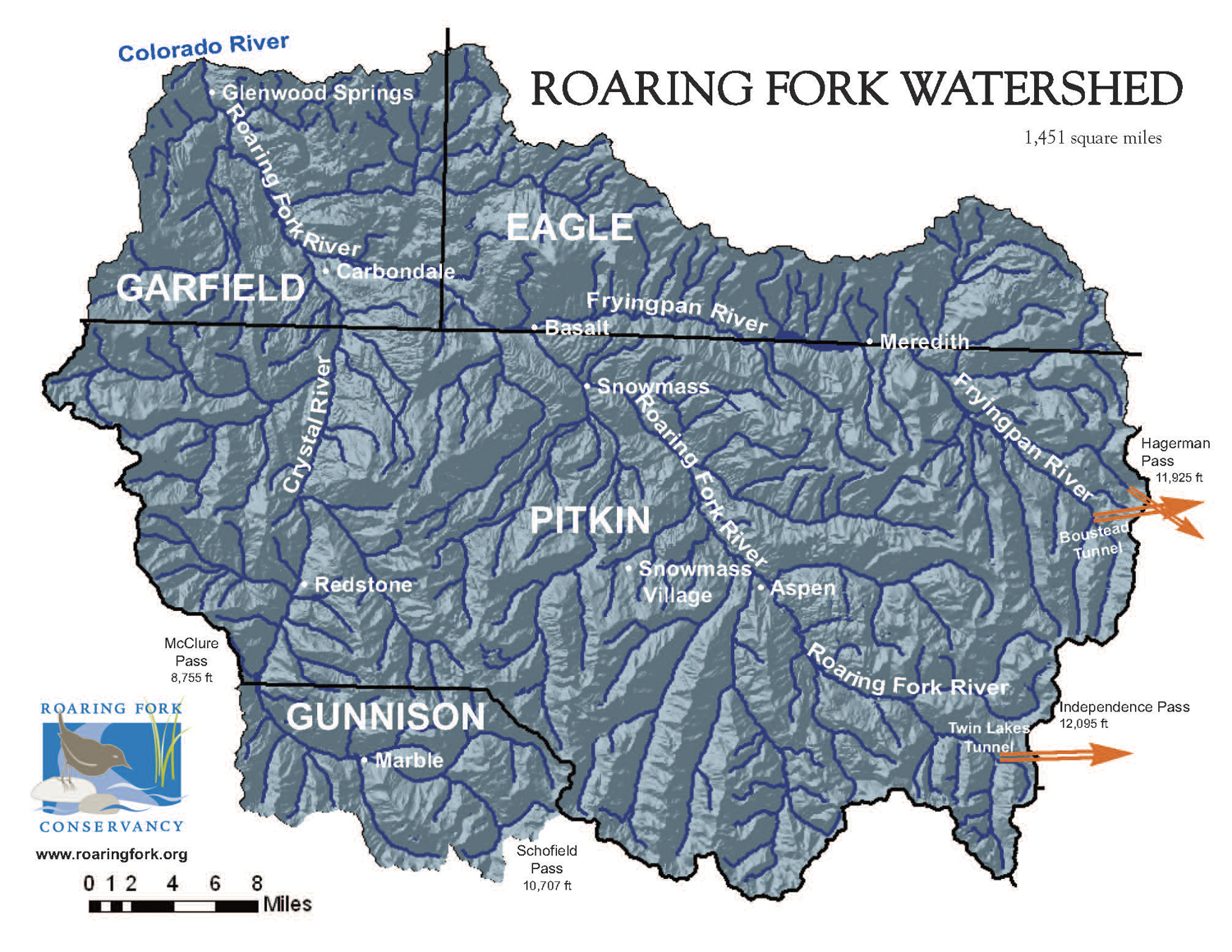
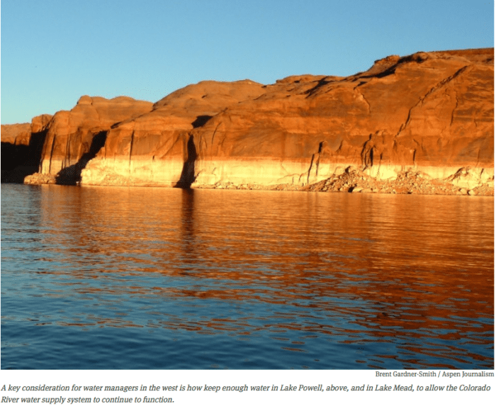
From his office along the Colorado River in Glenwood Springs, Eric Kuhn can see the bottom of Lake Powell.

Kuhn, the general manager of the Colorado River District, has been working for months on a study asking if future droughts will drop water levels in Lake Powell so low that Glen Canyon Dam won’t be able to produce hydropower or release enough water to meet downstream demands.

“If we were to have another 2000-2006 drought, with where our starting conditions are today, we would basically empty Lake Powell,” Kuhn told the board of directors of the river district last month in an update on the study. “Now, we’re not going to do that. No one will allow Lake Powell to become empty.”

But today, Lake Powell is already half-full after one of the driest 15-year periods on record in the upper basin.

And Kuhn said no one wants to see a “compact call” triggered because Colorado, Wyoming, and Utah fail to deliver enough water through the Glen Canyon Dam to California and Arizona.

Such a call could prevent those who own post-1922 water rights from diverting water from the river. And that includes most of the transmountain diversions in Colorado.

“As long as you keep water in Powell above minimum power [pool], you’ll never have a compact problem,” Kuhn told the board.

So the $52,000 risk study Kuhn is working on with Hydros Consulting of Boulder is looking at how much water the upper basin states may have to send to keep Lake Powell above two key elevations.

The first important elevation is 3,525 feet, which triggers an operational guideline for how the reservoir is managed. The second is 3,490 feet, which is the “minimum power pool” below which hydropower cannot be produced at Glen Canyon Dam.

Failure to meet the operational guideline could require, ironically, that the upper basin states release even more water, depending on the level of Lake Mead, thus dropping the water level in Powell even faster toward minimum power pool.

And failure to stay above minimum power pool could prevent the eight turbines inside Glen Canyon Dam from producing about $120 million worth of electricity a year.

Buyers of that electricity include the cities of Aspen, Glenwood Springs, Delta, Gunnison, and Colorado Springs and utilities including Holy Cross Electric Association and Public Service Co. of Colorado.

Once minimum power pool is reached, it may also be difficult to physically move enough water through the dam’s infrastructure to meet the terms of the Colorado Compact.

On Saturday, Aug. 13, the surface of Lake Powell was at 3,617 feet and was 52 percent full.

The reservoir can hold 26,215,000 acre-feet of water at full elevation of 3,700 feet, according to the Bureau of Reclamation.

Although the past three years have yielded average precipitation in Colorado, the period from 2000 to 2015 brought the lowest flows over any 16-year period since Glen Canyon Dam was completed in 1963, according to Reclamation.

The current operational guidelines provide that the upper basin now needs to release 8.23 million acre-feet (maf) of water a year to the lower basin, which Kuhn said has made significant progress on reducing its water usage and has set ambitious goals to use even less.

But Kuhn, and many other regional water managers, still want to know what will happen if drought returns while Lake Powell is half-full, as it is today.

What the study shows

The first phase of the study is now about three-quarters complete, Kuhn told the Colorado River District board in July.

The study’s methodology assumes only modest future water-supply development and then applies data from three different droughts in the last 25 years: the drought of 1988 to 1993, the drought of 2000 to 2006, and the drought of 2013 to 2014.

Kuhn said the model is showing, even with little new growth, that the upper basin can expect shortages ranging from 300,000 to 500,000 acre-feet in a relatively moderate drought.

In a severe drought Kuhn said the shortages could range from 500,000 to 1 million acre-feet, and in a drastic drought, some years could bring shortages of 1 million to 1.5 million acre-feet.

“This is what I call the ‘sticker shock,’” Kuhn said of those figures. “Basically, what we’re saying is if we were to have, under today’s conditions, one of these three droughts, we would go below our target of 3,525 feet.”

Another potential conclusion from the risk study is that any new transmountain diversion would only make it more likely that Powell would go below target levels.

“What we’re suggesting is that a new transmountain diversion could still divert, but only if there’s enough water in Lake Powell,” Kuhn told the board.

Kuhn put it another way during a presentation to the Gunnison River basin roundtable on Aug. 1.

“It is going to be a very high burden to show that a new transmountain diversion won’t impact system usages,” he said.

In fact, Kuhn said the model is showing that there has only been one year since 2000 that a new transmountain diversion wouldn’t have had a negative impact.

“So are you going to build a multibillion dollar project that is going to operate once in 20 years?” Kuhn said in Gunnison. “I don’t think so.”

That’s if the operator of such a system agrees not to divert in years that would hurt levels in Lake Powell, which is not a legal obligation under Colorado water law.

If there was no agreement to limit diversions, Kuhn said a new transmountain diversion that lowers levels in Lake Powell would mean that other water users in Colorado would have to cut back on their water use, and do so more frequently, perhaps as much as half of the years in the study’s 25-year forecast period.

“That’s a fairly important message,” Kuhn told the River District board.

And, he said, that’s without the increasing heat of climate change factored in.

“I haven’t shown the climate change hydrology because it just scares everybody,” Kuhn said. “This is the recent hydrology.”

Several options

Kuhn says water users in the upper basin have three main levers they can pull to keep Powell operational.

One is to continue cloud seeding 
efforts, which are underway but only marginally helpful.

A second is to release water from three big upstream reservoirs: Flaming Gorge Reservoir on the Green River, Navajo Reservoir on the San Juan River, and Blue Mesa Reservoir on the Gunnison River.

Those reservoirs “have the same purpose as Powell, which is to allow the upper basin to manage for the upper basin’s obligations,” Kuhn said.

Those three reservoirs can together release about 2 maf if needed, but they would be hard pressed to do that several years in a row, Kuhn said.

A third lever is to pay ranchers and farmers to fallow fields and leave the water in the river to run downstream to Lake Powell, often called “water banking” or “demand management.”

Demand management means using less water, or curtailing the amount of water put to a consumptive use.

In a severe multi-year drought, the system will need the releases from the three big reservoirs above Lake Powell and a lot of demand management, Kuhn said.

So what’s the tolerance for the risk that water levels will drop far enough in Powell to make significant levels of “demand management” necessary?

Kuhn said if we assumed a severe drought comes only twice in a 50-year period, we might just say, “we can live with it.”

And if drastic droughts occur three or four times in a 50-year period, Kuhn said, “we can probably, with the tools that we have and can reasonably implement, be able to address” the challenge.

But if there is a severe drought like 2000 to 2006, he said, “it will take the system beyond what we can do and then you’re going to have some big problems. That’s the message that the study suggests. The other message is, future demand matters.”

Editor’s note: Aspen Journalism and the Aspen Daily News are collaborating on coverage of rivers and water. More at http://www.aspenjournalism.

Warm Nights Tip the Scales as Summer Grinds On — WunderBlog

From WunderBlog (Bob Henson):

Data for July 2016 make it clear that this summer is worming its way into the nation’s warmest batch on record, thanks in large part to consistently sultry nights in many areas. Meteorological summer so far–June plus July–has been the fifth warmest for the contiguous U.S. in 122 years of recordkeeping, according to the July climate report released on Thursday by NOAA’s National Centers for Environmental Information (NCEI). Ahead of 2016 at this point are the scorching Dust Bowl summers of 1934 (#4) and 1936 (#1) along with the recent 2006 (#3) and 2012 (#2). The toasty summer so far is the result of the nation’s warmest June on record followed by its 14th warmest July. Last month’s warmth was focused across the nation’s southern and eastern halves (see Figure 1), with New Mexico and Florida each recording their hottest July on record. Fourteen other states made it into their top ten warmest for July.

Statewide rankings for average temperature during July 2016, as compared to each July since 1895. Darker shades of orange indicate higher rankings for warmth, with 1 denoting the coldest month on record and 122 the warmest. Image credit: NOAA/NCEI.

Warmest nights on record for June-July
It’s the muggy nights that are imprinting themselves on the psyche of millions of Americans this summer. The average daily minimum for the contiguous U.S. was the warmest on record for June and July combined: 60.57°F, beating out 2015, 2010, 2002, and 2006. (See Figure 2.) Warmer nights are a hallmark of a climate being heated by added greenhouse gases, and it’s long been recognized that nights should generally warm more than days, and winters more than summers, as climate change proceeds. Of the eight June-July periods with the warmest average daily temperatures (including both highs and lows), four are from Dust Bowl years. However, the eight years with the warmest average daily minimum temperatures are all from the 21st century. Urban heat islands are no doubt helping to increase overnight lows in large metropolitan areas; however, the nationwide extent of the trend toward warm nights goes well beyond this effect.

For the year to date through July, the U.S. has seen 15,061 daily record highs and just 2709 record daily lows, according to data compiled by meteorologist Guy Walton. In an email, Walton told me that “2016 is in a race with 2012 for that dubious distinction of having the highest ratio of record daily highs to record daily lows since 1920.”

[…]

Wet to the north, dry to the south
After an unusually dry June across the contiguous U.S., July produced generous rains across much of the nation’s northern tier, while leaving most of the Northeast and the nation’s southern half on the dry side. It was the second-driest July on record for Georgia and the third-driest for Florida, with Wyoming and New Mexico also coming in among their top-ten driest. July was among the ten wettest on record in five states: Illinois, Kentucky, Minnesota, Missouri, and North Dakota. The weekly U.S. Drought Monitor issued on Thursday morning shows that more than 40% of California remains in extreme or exceptional drought, a situation that is unlikely to change before the 2016-17 wet season arrives (if then). Much of the state remains extremely vulnerable to fast-growing wildfire, especially over the next several months. Wildland fire potential is also expected to increase across the South this autumn, according to the latest outlooks from the National Interagency Coordination Center. (Torrential rains scattered over parts of the upper Gulf Coast this week will help tamp down the immediate drought and fire risk in those areas.)

The wet-north/dry-south tendency evident in July may be a foreshadowing of La Niña influence to come (see Figure 4 below). The strong El Niño of 2015-16 is giving way to borderline La Niña conditions, with the weekly index of sea-surface temperatures in the Niño3.4 region hanging near the -0.5°C threshold of La Niña over the past month. NOAA maintained a La Niña Watch in its monthly ENSO discussion issued Thursday, although the event is projected to be relatively weak if it does take shape. NOAA is giving a 55-60% chance of La Niña being present this fall and winter and a negligible chance of El Niño (below 10%). Because La Niña typically leads to a more consolidated jet stream, it often leaves southern parts of the 48 states on the dry side of upper-level flow as storm systems whip across the nation’s heartland, keeping northern areas more moist.

Funding problems for Fountain Creek flood control project

The Fountain Creek Watershed is located along the central front range of Colorado. It is a 927-square mile watershed that drains south into the Arkansas River at Pueblo. The watershed is bordered by the Palmer Divide to the north, Pikes Peak to the west, and a minor divide 20 miles east of Colorado Springs. Map via the Fountain Creek Watershed Flood Control and Greenway District.

From The Colorado Springs Gazette (Matt Steiner):

DOLA had awarded the county $945,000 in Community Development Block Grant money in late 2015 for a much-needed project along Fountain Creek near U.S. Highway 85/87 south of Colorado Springs, but in June, the county got some bad news:

The award would be much smaller than expected.

Federal guidelines cap at $250,000 the money that can be given out for projects that involve the Army Corps of Engineers – which is administering the work near 85/87 and Maxwell Street.

The project, necessary after torrential floods badly damaged the banks of the creek in September 2013, would shore up a 1,000-foot section of the creek, keep the highway safe and prevent eroded river banks from approaching a mobile home park during the next large flood event.

“Now we have a fear of losing this project,” Brian Olson of the county’s budget division said Friday. “If we don’t have the funding on this, they’ll take that money and use it somewhere else.”

The total cost of the work is estimated at more than $2.5 million, according to a May 2015 project overview. The Army Corps of Engineers will pick up three quarters of that tab, and the rest was expected to come from the money awarded to El Paso County, but the cap leaves the county short.

“We’re still trying to figure how we can fill that gap,” county Commissioner Sallie Clark said.

Olson said the project is doing feasibility analysis, a study that will cost the county $180,000. If the Army decides the project isn’t worth the cost, no grant money will be available at all, Olson said. The actual cost the county must pay will be determined after the feasibility study is complete.

While the county still has at least two months before the feasibility study is complete and the Army Corps’ determination on the value of the project is made, the county has shown urgency about finding alternate sources of money. They hope to receive some assistance in solving that problem.

“The state has got a lot on their plate,” Olson said. “They made an error on this. I’m hoping they’ll help us get through this thing.”

#ColoradoRiver: The Plan to Strengthen Denver’s Water Supply — 5280.com #COriver

Gross Dam enlargement concept graphic via Denver Water

From 5280.cm (Amy Thomson):

Considering the Denver region is growing by an average of 4,500 new residents per month, a large sector of the population likely doesn’t remember the catastrophic 2002 drought. The most severe water shortage since the Dust Bowl, snowpack and soil moisture were at all-time lows, and we remained in a dry period until 2006. Luckily, with water restrictions in place, we never actually ran out of water—we just got really close.

“We realized that we had an immediate need to correct a vulnerability in our system,” Denver Water CEO Jim Lochhead says. That’s when Denver Water started planning the Gross Reservoir Expansion Project, and after more than a decade of negotiations, the project (which was recently endorsed by Gov. John Hickenlooper) is underway.

But will it be enough? The short answer is yes—as long as Denverites work on strengthening their water conservation practices. Lochhead was pleased to note that when a storm comes through the Mile High City, there is a noticeable drop in outdoor water use, because well-informed residents are turning off their sprinkler systems. Denver residents have managed to reduce water consumption by more than 20 percent in the last 15 years, even with a 15 percent increase in population, according to Lochhead.

The decrease is not enough to mitigate the risk of drought, however. As Colorado’s largest water utility, the Denver Water system is made up of two collection systems—the Northern and the South Platte—and they are incredibly imbalanced. About 80 percent of the water comes from the south system, leaving the north very vulnerable to low rainfall or wildfires. During the notable dry years of 2002 and 2013, clients in the north end were lucky their taps continued to flow.

“We were literally only one drought away from a major problem in our system,” Lochhead says, noting that as recently as 2013, the system was virtually out of water in the north-end.

Teens help with river restoration project as part of North Fork flood recovery By Pamela Johnson — the Loveland Reporter-Herald

The Big Thompson River September 14, 2013 via The Denver Post

From The Loveland Reporter-Herald (Pamela Johnson):

The project, spearheaded by Wildlands Restoration Volunteers, is wrapping up, and a crew of teens attending a fly-fishing camp this week planted trees, shrubs and grass on a section of the river about 2 miles above Drake as part of the final touches…

The Big Thompson River and the North Fork suffered severe damage during the September 2013 flood. Torrents of water wiped out homes, sheds, trees, boulders and anything else in their path and left behind destruction that, in many places, resembled a barren moonscape…

During the aftermath of the flood, Wildland Restoration Volunteers began reaching out to find ways to help restore trails, wildlands and sections of the river.

They connected with Chenoweth and other landowners and applied for state grants to redesign and rehabilitate a 2.5-mile section of the North Fork to be studied and used as an example for future projects. Most of the land in the project is owned by the Chenoweth family and Colorado Parks and Wildlife.

With $360,000 in grants and $140,000 worth of donated time and supplies, crews and volunteers have realigned and regraded the river channel to make the river and surrounding habitat healthy and more able to survive a future flood.

This included specifically designing the depth of pools in the river, carefully placing rocks to create ripples in the water and to stabilize the bank and creating areas along the river that will allow water to slow down and spread out in the event of another flood.

The next step was to plant vegetation along the river to enhance habitat and to protect the banks from erosion.

The teens from the Rocky Mountain Flycasters Fly Fishing Conservation Camp worked on the planting this week, putting in willows, cottonwoods, dogwoods, chokecherry trees and native grasses.

Luke McNally, who works for Wildland Restoration Volunteers, pointed out to the teens the trees that survived the flood as well as grasses that have returned since. But, he noted, the amount of plant life is nothing compared with what was there before the flood…

The goal of the camp, which is in its seventh year, is for the teens to learn about fishing as well as ecology and conservation and to stir in them a love of the outdoors and a desire to protect the lands, noted Dennis Cook, camp director and a member of Rocky Mountain Flycasters.

Storm pattern over Colorado September 2013 -- Graphic/NWS via USA Today
Storm pattern over Colorado September 2013 — Graphic/NWS via USA Today

#RioGrandeRiver: “It looked like taking samples from a mud puddle” — Ashley Rust

West Fork Fire June 20, 2013 photo the Pike Hot Shots Wildfire Today

From The Pueblo Chieftain (Matt Hildner):

When the Papoose and West Fork fires burned 88,000 acres in the upper Rio Grande basin in 2013, water and wildlife officials feared the worst.

With 53,000 acres of the burn scars classified as moderate or severe, they feared rainstorms would wash dirt and ash into streams, suffocating fish and even clogging irrigation works on the San Luis Valley floor.

Those concerns have been squelched, if not by laymen’s observations, then by the work of a researcher at the Colorado School of Mines who’s spent the last three years studying water quality below the burn scars.

With some exceptions on the river’s tributaries, the Rio Grande’s water quality and its fish have survived fine.

“Nothing really changed on the Rio Grande,” said Ashley Rust, a doctoral student in hydrological science. “Everything looks great and still continues to look great.”

Rust, whose work was partially funded by the Rio Grande Watershed Emergency Action Coordination Team, installed six water-quality probes on the main stem of the Rio Grande and another four on tributaries that run through the burn scar.

There were no metals that exceeded water quality standards. There was initial concern that abandoned mines were burned and held the potential to leak pollutants…

Nor were there any increases in the amount of nutrients, such as phosphates, nitrates and nitrites, that sometimes happen after fire.

But measurements for suspended solids, an indicator of how much dirt is in the water, and turbidity, or water cloudiness, have spiked on the Rio Grande’s tributaries during rainstorms.

Problem areas, such as Trout Creek southwest of Creede, have either especially steep slopes or severely burned soils.

Those areas have had turbidity measurements that reach 50 nephelometric turbidity units — roughly the point at which trout begin to die from suffocation. Some measurements reached as high as 3,000.

Perhaps the biggest fish kill tied to the burn scars came on Trout Creek at the beginning of August 2014, when a hillside gave way following a rainstorm.

Rust heard of the fish kill and went to take samples.

“It looked like taking samples from a mud puddle,” she said.

She returned to the stream last year and found newborn fish downstream from the debris flow and fouryear- olds above it, leading her to conclude that the population will come back without stocking.

Rust’s findings coincide with what anglers have found, especially on the Rio Grande.

High Fryingpan water flows are 
vexing anglers

An angler on the Fryingpan River, in the flat section not far below the reservoir, with a flow of 250 cfs. Releases from Ruedi for the benefit of endangered fish in the Colorado RIver near Palisade have brought the river up to 300 cfs.
A USGS graphic showing the increase in flows in the Fryingpan River below Ruedi Reservoir from Aug. 11 to Aug. 13, 2016. The flows were increased 50 cfs from 250 to 300 cfs.


By Brent Gardner-Smith, Aspen Journalism

BASALT – Flows in the lower Fryingpan River below Ruedi Reservoir were increased on Friday afternoon to about 300 cubic feet per second, much to the dismay of professional and private anglers who prefer a flow of no more than 250 cfs.

“We get cancellations at 250 and up,” said Warwick Mowbray, owner of Frying Pan Anglers in Basalt, during a meeting Thursday night in Basalt’s town hall on flows in the Fryingpan. “People say ‘We can’t wade.’”

Releases from Ruedi were increased Friday in order to send more water to the “15-mile reach” of the Colorado River between Palisade and Grand Junction for the benefit of endangered fish species struggling to survive in the river below several big irrigation diversions.

But the water released from Ruedi and sent down the Fryingpan, Roaring Fork and Colorado rivers to the 15-mile reach at the direction of the U.S. Fish and Wildlife Service erodes the quality of the trout-fishing experience on the lower Fryingpan, according to Will Sands, manager of Taylor Creek Fly Shops in Basalt and Aspen.

“Over 250 cfs changes the dynamic of the environment of the river for hatches and the abilities of the visiting angler,” Sands said. “It hits 300 and we start getting cancellations.”

Rick Lofaro, director of the Roaring Fork Conservancy, seconded the concerns of the professional anglers.

“When you have additional water coming down, it challenges wading and changes the character of the river,” he said, likening higher flows in the Fryingpan to paying for a backcountry powder tour only to find no fresh snow. “I think there is a big difference between 250 and 300 from an accessibility and wade-ability level.”

The conservancy commissioned a study in 2014 that showed fly-fishing contributes $3.8 million to Basalt’s economy.

Thursday’s meeting in Basalt was called by officials from the Bureau of Reclamation and the Fish and Wildlife Service, and about a dozen citizens showed up to discuss likely releases from Ruedi for the balance of the summer.

Tim Miller, a hydrologist with the Bureau of Reclamation who manages Ruedi Reservoir, said releases below the reservoir would likely be around 300 cfs into September, but could be as high as 350 cfs if there is a call for more water from irrigators in the Grand Junction area.

Since July 18, flows in the lower Fryingpan have been running steadily at around 245 cfs, a sweet spot for anglers.

Jana Mohrman, a hydrologist with the Fish and Wildlife Service, manages a pool of water in Ruedi that can be released to keep enough water in the 15-mile reach.

She works toward meeting seasonal flow levels — now 1,240 cfs — in the Colorado River near Palisade by directing “fish water” to that point on the river from a variety of upstream reservoirs, including Ruedi, Wolford and Green Mountain.

This week, flows in the Colorado River near Palisade had dropped to the point where several fish passages designed to allow native endangered fish to swim upstream toward Rifle were not functioning due to low water levels.

“I’m using Ruedi to get my fish passages open,” Mohrman said.

As such, she directed the Bureau of Reclamation to release another 50 cfs from Ruedi starting Friday. That was on top of the 140 cfs of “fish water” that was already being released, which was in addition to about 110 cfs of routine releases from the reservoir.

The crest of the dam across the Fryingpan River that forms Ruedi Reservoir, which can hold 102,373 acre-feet of water.

Fish water

Mohrman’s pool of “fish water” in Ruedi equals about 15,000 acre-feet of water. But she can also use, for the second year in a row, about 9,000 acre-feet of water owned by the Ute Water Conservancy District in Grand Junction and leased to the Colorado Water Conservation Board for use in the fish-recovery program.

On Wednesday, during a weekly conference call of regional reservoir managers and irrigators, Mohrman was pressured by irrigators in the Grand Valley to release more water from Ruedi along with water they were releasing for the fish from Green Mountain Reservoir, which serves as a back-up supply water for the Grand Valley.

Last year, 24,412 acre-feet of water was released from Ruedi to the benefit of the fish recovery program and a similar amount is likely to be released this year. In all, Ruedi can store 102,373 acre-feet of water.

Of that, about 41,000 acre-feet is owned by various entities, and can also be released upon demand in a dry year. Should that occur, flows in the Fryingpan could rise still higher, and not just because of the fish-recovery program.

“These demands on the reservoir are only going to grow,” said Miller of the Bureau of Reclamation. “This isn’t going away.”

The lower Fryingpan River on Thursday, Aug. 11, flowing at about 250 cfs.

Conflicting priorities

Dan Turley, a homeowner in the Fryingpan River Valley and an avid angler, asked Mohrman if the endangered fish program was a higher priority than the recreational economy of Basalt.

“This is not a trivial inconvenience,” Turley said of flows in the Fryingpan going up to 300 cfs. “It makes the river not viable to fish for a great majority of people.”

And Turley said it’s not just about Basalt’s economy.

“A lot of people from Aspen come down here and fish,” he said. “They are staying at The Little Nell. This is a big deal.”

“It’s always been considered,” Mohrman said, referring to the local fly-fishing economy and a targeted flow of 250 cfs in the Fryingpan. “And we have always said we would try to maintain 250. But we also have to recover these fish, and we’ve built all these structures to try and get them up to Rifle to get back into their natural habitat. And that is a higher priority than the 250 target.”

The goal of what’s called the Upper Colorado River Endangered Fish Program is to maintain populations of four species of large fish native to the Colorado River, the Colorado pikeminnow, razorback sucker, bonytail, and humpback chub.

If the program fails to maintain viable populations of native fish, diverters in the Colorado River basin could be faced with extensive environmental reviews of their diversion’s effects on the endangered fish — something regional water managers want to avoid.

As long as the fish populations are stable or growing, the recovery program provides blanket environmental protection. Trouble is, Mohrman said the fish are not doing all that great as they are being preyed upon by non-native fish in addition to struggling with low river levels.

A USFWS employee holding a smallmouth bass, caught via electrofishing, that just swallowed a native bluehead sucker. Non-native fish eating  young native fish is a big obstacle to developing healthy populations of native fish.
A USFWS employee holding a smallmouth bass, caught via electrofishing, that just swallowed a native bluehead sucker. Non-native fish eating young native fish is a big obstacle to developing healthy populations of native fish.

Bypass pipeline?

Rachel Richards, a Pitkin County commissioner who has focused during her tenure on water issues, attended Thursday’s night meeting.

She raised the idea of a pipeline or flume that would allow water to be released from Ruedi without flowing down the river itself.

“We’ve always talked a little bit about should there be a separate flume or waterway for the Ruedi releases so they are not destroying the Fryingpan,” Richards said.

She also said that Pitkin County and Basalt had voiced concerns in the past about releasing “fish water” from Ruedi and making Basalt a “sacrificial lamb for water needs elsewhere in the state.”

At the conclusion of Thursday’s meeting, Mohrman said she would work with irrigators and reservoir managers to see if more water can’t be released from reservoirs other than Ruedi.

“I’ll try and cut it back as the Green Mountain Reservoir ups its releases and our fish passages stay open,” she said. “I understand your very serious concerns.”

Editor’s note: Aspen Journalism, the Aspen Daily News, and Coyote Gulch are collaborating on coverage of rivers and water.The Daily News published this story on Saturday, August 13, 2016.

#ClimateChange a factor in Vail Resorts swallowing of big fish of Whistler — The Mountain Town News

whisblacktrailmapFrom The Mountain Town News (Allen Best):

“There was a certain inevitability to it,” said Michael Berry, president of the National Ski Areas Association. After all, he explained, Whistler Blackcomb is the busiest ski area in North America in terms of gross skier days and volume. It did 2 million skier visits last winter, while Vail Mountain and Breckenridge usually come in at about 1.6 million.

That made it an attractive acquisition for Vail. The Denver Post noted that the sale price represents more than 11 times the EBITDA (a measure of earnings) of Whistler Blackcomb, compared to the 8 to 9 times that is typical of ski area sales.

Press releases described the purchase as a “strategic combination” but the financial press dispensed with that sweet-talking formality. It’s a sale, which company officials said they expect to close in 75 days or less. It will benefit owners of Whistler Blackcomb handsomely. Bloomberg Gadfly said investors in the company’s initial public offering in November 2010 stand to triple their initial investment and “definitively beat the performance of benchmarks” like the S&P 500 and the Canadian counterpart, the S&P/TSX Composite Index, over the same period.

The biggest single winner in the sale is Denver-based KSL Capital Partners, a rival to Vail in the Truckee-Tahoe area of California. It has a 24 percent ownership of Whistler Blackcomb.

The cliamte change factor

Chief executives from both Vail Resorts and Whistler Blackcomb emphasized diversity in their conference calls with investors. Rob Katz, CEO of Vail, has long expressed interest in improving geographic diversity. Vail already has four major ski areas in Colorado, one in Utah, and three in California, plus smaller ski areas in the Midwest and one in Australia.

To an extent, this buffers Vail from droughts. It already had some diversity, as was apparent in the last several years. The company’s resorts in the Sierra Nevada struggled in the absence of snow for several years, but its resorts at Park City and along the I-70 corridor in Colorado did reasonably well.

Adding Whistler Blackcomb to the mix gives Vail Resorts even more geographic diversity – and a stronger buffer against bad weather.

Fountain Creek damage in 2015 pegged at $76 million — The Pueblo Chieftain

Overton Road flood damage photo via KOAA.com.

From The Pueblo Chieftain (Chris Woodka):

More than one-quarter of the banks along Fountain Creek were severely damaged by last year’s continual high water that would cost $76 million to fully repair.

Mostly in Pueblo County.

That assessment was given Friday to the Fountain Creek Watershed Flood Control and Greenway District by Executive Director Larry Small…

That’s significant because it shows the prolonged flows from increased water in Fountain Creek are more destructive than the one-time spikes in volume typical of flash flooding. It also shows there was more damage than the high visibility impacts, such as the washout of Overton Road, the exposure of buried cables and utility lines, the threat to operational railroad tracks and damage to individual property owners.

The results came after an aerial survey that is part of collecting data for an upcoming needs assessment study. Both sides of Fountain Creek between Colorado Springs and Pueblo were studied, about 102 miles of river bank.

Severe damage — altering the shape of the bank or the course of the stream — was found along sections totaling 28 miles. The damaged areas are not in one place but spread throughout the 50 miles along Fountain Creek, Small explained.

Small estimated the damage at $76 million based on the average cost of restoration to stream banks at $500 per foot.

The district does not have money to make repairs on that scale. Right now, it is embarking on a $2.5 million project to repair about 1,500 feet of bank on the Masciantonio property in Pueblo County, about 10 miles north of Pueblo.

A demonstration project on the Frost property in El Paso County had been completed but washed out in the 2015 flooding because of the high volume of water over a six-week period.

Small said assessments of how to proceed will be determined with more on-the-ground inspections.

EPA lawsuit accuses Wildcat Mining Corp. of violating Clean Water Act near Durango

wildcatmininglaplatacounty

From The Denver Post (Bruce Finley):

The EPA lawsuit, filed Monday in federal court, accuses Wildcat of violating the Clean Water Act by dumping fill material without permission into Little Deadwood Gulch as part of a road work to reach a mine portal. The gulch seasonally feeds water into the La Plata River. The EPA also contends Wildcat improperly enlarged the road and built a wastewater pond in wetlands.

Wildcat has responded by negotiating a deal with federal prosecutors to settle the lawsuit, if approved by a judge. Wildcat would pay $50,000 in fines and begin work to restore the damaged creek.

“As long as Wildcat/Varca pay the civil penalty and comply with the restoration and mitigation plan, they can go forward with their mining activities from EPA’s perspective, though subject to regulation by (the Colorado) Division of Reclamation Mining and Safety and other state entities,” U.S. Department of Justice spokesman Wyn Hornbuckle said.

The feds said they’d make the consent deal available for public comment once it is published in the Federal Register.

Wildcat owner George Robinson did not return phone calls and could not be reached to comment.

The August 2016 Headwaters Pulse is hot off the presses from CFWE

headwaterspulse092016cover

Click here to read the current newsletter. Here’s an excerpt:

Paying for what’s ahead

Money. We all know it doesn’t grow on trees. As Colorado works to balance funding priorities for public safety programs, human services, transportation, education, and other government spending areas, Coloradans will need to come up with about $20 billion by 2050 for water projects across the state. The question is: How will we do it, and what will it mean for our bank accounts? That $20 billion figure is what the Colorado Water Conservation Board estimates is necessary to implement Colorado’s Water Plan.

“[The water plan] identifies a lot of solutions for the state and comes with a very high price tag,” says Margaret Bowman, a consultant working with the Water Funder Initiative to develop impact investing in the West. “Now the state’s got to figure out how to finance it.”

headwaterssummer2016economicscover

Our summer issue of Headwaters magazine takes an in-depth look at water finance and other aspects of water economics. Click here to read the issue’s feature article “Paying for What’s Ahead” by Headwaters associate editor Caitlin Coleman as she explores traditional water financing mechanisms like bonds, loans and grants, plus new innovative pathways to securing funding through private investors, public-private partnerships, and philanthropic institutions. And read the rest of the issue for more water economics coverage such as water rates, water markets, and other valuation methods that attempt to put a price on an indispensable good.

#Drought news: The South Platte Basin is drying out some

Click here to go to the US Drought Monitor website. Here’s an excerpt:

The Plains and Midwest

Moderate to heavy rain fell in a band from northern New Mexico northeastward through much of northern Oklahoma, Kansas, and the southern and northern reaches of Missouri, and adjacent Iowa last week, with amounts of 3 to 5 inches recorded in a few spots in north-central Missouri and adjacent Iowa, northern and southern Kansas, and northeasternmost New Mexico. Farther north, moderate to heavy rain was also observed in a smaller swath covering south-central to southeastern Nebraska. Light to moderate totals were observed in the central High Plains and eastern Iowa, and only a few tenths of an inch at best fell elsewhere. This pattern of variable precipitation amounts prompted numerous changes of relatively small scale. For instance, patches of deterioration were noted in South Dakota, western Iowa, and south-central Oklahoma while improvements were introduced in southern Nebraska, southeast Oklahoma, southern Kansas, and areas near the Iowa/Missouri border…

The Rockies and West

Seasonable monsoon rainfall was observed in Arizona (generally eastern areas), New Mexico, and the southern half of Colorado while little or no precipitation fell elsewhere, which is not uncommon this time of year. The precipitation pattern per se did not warrant making Drought Monitor changes, but water supply assessments undertaken in some states led to a more pessimistic re-assessment of conditions, particularly in Montana, and these are reflected in the Drought Monitor this week. Reservoir levels, streamflow levels, and surface moisture conditions prompted expansion of abnormal dryness and moderate drought, along with the introduction of large areas of severe drought, across the southern, central, and western sections of Montana. Smaller-scale deteriorations were also introduced in part of Idaho and Oregon…

Looking Ahead

During the next 5 days (August 11 – 15), heavy precipitation (more than 1.5 inches) is expected in a broad swath from the Big Bend region in Texas eastward through upper central Texas, most of the Mississippi Valley, the adjacent central Gulf Coast, the Ohio Valley, the western Great Lakes region, and interior sections of the Northeast and New England. Amounts may reach 4 to 8 inches in the eastern half of Louisiana and adjacent locations, 3 to 6 inches in the Big Bend, 2 to 5 inches in the upper Midwest (centered near the Wisconsin/Iowa/Minnesota triple point), and 2 to 5 inches along and just north of the Ohio River. Moderate amounts are anticipated in the Southwest, eastern Colorado, most of Florida, the central Plains, and the southern reaches of the Northeast and New England. A few tenths of an inch at best are expected in most other areas, although amounts may approach an inch in the southern Appalachians. High temperatures will average a few degrees above normal in the Great Lakes region, mid-Atlantic, and Northeast, as well as the West Coast states away from the immediate coastline. Near- or below-normal temperatures seem likely elsewhere.

During August 16 – 20, the odds favor wetter than normal weather in a broad swath from the southern Rockies eastward through the southern Plains, lower Mississippi Valley, mid-Atlantic region, and Southeast (outside the Florida Peninsula). The odds also favor wet weather in the northern Great Plains. However, enhanced chances for drier than normal weather exist in the Northwest, the Intermountain West, central sections of the Rockies and Plains, and southern and eastern portions of the Great Lakes region. The odds favor warm weather from the Rockies westward, from the Appalachians eastward, and along the northern one-third of the Nation. In contrast, cooler than normal weather is favored from the Southwest eastward through the lower Mississippi Valley away from the immediate Gulf Coast.

Drones help scientists track changing conditions — The Pueblo Chieftain

dronecowpopularscience

From The Pueblo Chieftain (Chris Woodka):

Early warning of floods coming off wildfire scars to more accurately estimating runoff from snowpack could be improved with drones, the Arkansas Basin Roundtable learned this week.

“It’s another tool to validate Snotel data to focus on the timing and volume of water,” said John Fulton, a hydraulic engineer with the U.S. Geological Survey.

Drones, along with new technology that uses groundbased portable radar equipment to measure water levels and velocity, can detect in advance when debris flows come off burn scars such as Waldo Canyon, a 2012 fire near Colorado Springs, or this year’s Hayden Pass Fire still smoldering in Fremont County. The drones are able to map steep terrain that otherwise would be inaccessible, Fulton said.

“We use the drones along with ground-based imagery to gauge the probability of debris flows,” he said.

Fulton explained the practical applications of drones in the Arkansas Valley along with Jeff Sloan, who heads the national Unmanned Aircraft Systems project for the USGS. They brought a couple of samples to the roundtable meeting at Pueblo Community College Wednesday, a fixed-wing model and a four-rotor hovercraft.

“I’m disappointed you didn’t fly one around the room,” laughed Sandy White, the roundtable chairman.

The technology has improved tremendously since the USGS started its drone program in 2008, Sloan said. The USGS started using the Honeywell T-Hawk, an Army surplus model. Now, equipment runs more silently and some of it is easy to learn to fly.

“It sounded like a flying lawn mower, so it wasn’t very good for observing wildlife,” Sloan laughed.

The Department of Interior began looking into the program to improve mapping vast tracts of federal land with better accuracy. Smaller drones are able to fill a gap with sharper images — down to 4 square centimeters — than higher flying drones, aircraft or satellites provide.

And cheaper.

Showing side-by-side images, Sloan pointed out that a $400 digital camera mounted on a small drone at low altitude produced a clearer image than a $1 million imaging system on a satellite.

Besides cameras, drones can provide images using thermal, multispectral, hyperspectral, Lidar (light radar) and magnetometry equipment.

Using GPS, it is possible to create multilayer maps of areas relatively cheaply.

Drones also allow better real-time monitoring, such as the landslide-prone DeBeque Canyon in Western Colorado, Sloan said.

“An ice core without any depth references — I shouldn’t say this — it’s good for margaritas” — Geoffrey Hargreaves

From the Associated Press (Dan Elliott):

Smooth and milky white, the 4- to 5-inch-diameter pieces — called ice cores — provide scientists with a wealth of historical information, from air temperature to greenhouse gases to evidence of cosmic events. The record reaches as far back as 800,000 years.

The ice is the remnant of centuries of snowfall, compressed by the weight of successive years of accumulation.

“You can drill into it, and it’s much like looking at tree rings,” Fudge said. “It’s just year after year after year of climate information that’s preserved out in the ice sheet.”

Specialized drilling rigs pull the cores from as deep as 9,800 feet below the surface of the ice sheets. Crews then tuck them into protective tubes, pack them in chilled containers and ship them to the U.S. Refrigerated trucks haul them to Colorado lab, which is funded by the National Science Foundation.

In a bustling, white-walled workroom in the Lakewood freezer — kept at about minus 11 Fahrenheit — workers push the cores through a series of saws on metal frame benches, divvying up the ice according to a prearranged pattern for different experiments.

Part of every ice core is archived in another, larger room at about minus 33 degrees, so future researchers can verify old results or try new tests. The archive contains nearly 56,000 feet of ice.

Scientists tease data from the ice in various ways. Differences in the weight of molecules in the frozen water hold clues about the air temperature at the time the snow fell.

Air trapped in bubbles can be analyzed to measure how much carbon dioxide and other gases were in the atmosphere when the ice formed.

A solar flare or other cosmic events can leave distinctive radioactive atoms on the snow. Dust blown in from distant continents offers clues about atmospheric circulation.

“The ice sheets are in direct contact with the atmosphere,” said Mark Twickler, the lab’s science director. “Everything that’s in the atmosphere we capture as time goes by, and it gets buried in snow.”

The depth of the core and evidence of volcanoes help determine how old the ice is.

Scientists already know when major eruptions occurred, so a layer of volcanic residue indicates the year the adjacent ice formed. That becomes a reference point for annual layers above and below.

The record is remarkably precise, even reflecting seasonal changes, scientists say.

“It’s as if we’re standing on the ice sheet writing down the temperature for the last 800,000 years,” said Bruce Vaughn, a University of Colorado-Boulder lab manager who works with the ice. “It’s that good.”

Without a record of its depth and age, the ice has little research value, said Geoffrey Hargreaves, curator of the Lakewood lab.

“An ice core without any depth references — I shouldn’t say this — it’s good for margaritas,” he said, poker-faced.

Dipping straws into the Ogallala — The Hutchinson News

From The Hutchinson News (Jim Schinstock):

“Pulling a well” was one of the many chores I had growing up on a farm in western Kansas. Usually this involved pulling the pump to the surface, changing the leathers and cleaning the sand screen, then lowering the pump through the pipe back to the water below. Sometimes it involved working on the gears on the windmill head some 20 or 25 feet above the ground. And once in a while we had to change out a pipe that had sprung a leak.

I haven’t pulled a well in over half a century, nor do I miss the experience. But back in those days, we had good sweet water at about 30 feet. Nowadays, wells have gotten deeper because the water table continues to get lower. The same 30-foot well would have to be redrilled to over 100 feet to reach water.

And that is because the Ogallala Aquifer can’t keep up with the demand for water. Since it takes about 480 gallons of water to raise and process a quarter-pound of beef, think of that number the next time you drive by a feedlot or go through a McDonald’s drive-thru.

The Ogallala, also known as the High Plains Aquifer, is an irregular, undulating sponge that soaks up rain and groundwater. The Ogallala holds about 2.9 billion acre-feet of water, roughly the same amount in Lake Huron. About two-thirds of the water lies beneath Nebraska, where the Ogallala is thickest and most saturated. Running south from Nebraska, the Ogallala meanders through seven states to Texas on the south end. All along its course, the Ogallala varies markedly in thickness and saturation levels. If you think of the Ogallala as a milkshake, the question becomes where to put your straws and how deep into the milkshake. Eventually the milkshake is empty.

The culprit in the draining of the Ogallala is irrigation, and the “straws” are all the wells poking into the aquifer. As demand for water exceeds supply, wells become more numerous and deeper. Clovis, New Mexico, currently uses 73 wells to provide less water than 28 wells delivered in 2000. This isn’t an isolated phenomenon. Many small towns and cities are in danger of, literally, “drying up.”

The eight states impacted by the Ogallala also have different rules for pumping from the aquifer. Texas has no regulations, and users can take as much water as they want, even selling it to others. Nebraska and Oklahoma require “reasonable use and shared rights,” with water rights shared proportionately to acreage. The remaining states – Kansas included – deny new applications and protect existing water rights by seniority.

And the beat goes on. From 2000 to 2008, the Ogallala declined at twice the rate of the previous decade. The aquifer lost, on average, 8.3 million acre-feet of water each year, roughly half the flow of the Colorado River running through the Grand Canyon.

Dust from the drought-hit Southwest ups avalanche danger in the Rockies — Bob Berwyn

Dust streaming across Four Corners April 29, 2009 via MODIS

From BeaconReader.com (Bob Berwyn):

We all know what a blanket of fresh snow is supposed to look like — it’s the stuff of poetry. And for skiers and snowboarders, it’s the magic carpet that carries us beyond the edge of gravity, free-falling down mountainsides immersed in a spray of frozen crystals.

But for the last 10 years, the snows falling in parts of the Colorado Rockies have been far from virgin white. From March through May, the mountainsides sometimes look more like gravy covered mashed potatoes, as regional weather patterns blow huge amounts of desert dust to the high peaks of the San Juans and beyond. Instead of skimming down the slope with wings on your feet, skiers sometimes find themselves stuck in the muck. In a worst-case scenario, you might even double-eject out of your bindings if you hit a particularly sticky patch in a transition area.

Much of that seasonal dust is coming from dry lake beds in Arizona, from arid grazing lands around the Four Corners area and from intensively used recreation and energy development areas in the wider region. Satellite images clearly show the source and the deposition areas, and 10 years of detailed data from snow-study plots around the Colorado mountains show how the dust is affecting snow and water.

Report: Protecting source water in #Colorado during oil and gas development

ProtectingSourceWaterAugust2016cover

Click here to read the report. Here’s an excerpt:

ABOUT THIS GUIDE
This guide is intended for water providers and community members interested in learning more about water quality protection during oil and gas develop- ment. The information contained in this guide is provided for educational purposes only and does not constitute legal advice. It is intended to be up to date as of the time of publication, but likely will not remain current over the passage of time. This guide is not a substitute for a consultation with an attorney licensed in Colorado or your jurisdiction who can properly advise you regarding your specific situation.

ACKNOWLEDGMENTS
This report is a collaborative effort by the Intermountain Oil and Gas BMP Project, the Colorado Rural Water Association, AirWaterGas and Western Resource Advocates. The lead authors of the report are Matt Samelson and Matt Sura. Kathryn Mutz (Intermountain Oil and Gas BMP Project), Dylan Eiler, Paul Hempel, Tom Wall, and Colleen Williams (Colorado Rural Water Association), and Joan Clayburg and Laura Belanger (Western Resource Advocates) are the review editors. We would like to thank John Duggan and Dave Rogers from the Colorado Water Quality Control Division, Mike Paules, Regulatory Advisor at WPX En- ergy, and Mark O’Meara, Town of Carbondale Utilities Director for their assistance and review of this document. Their experience and thoughtful suggestions improved the quality of this report. We would also like to thank Matt Schechter of the University of Colorado Boulder Of ce for Outreach and Engagement for design of this guide. The authors take full responsibility for any mistake found in this report, and the review of this document by the above entities does not imply their agreement with or endorsement of the concepts, analysis, methodologies, or conclusions of this report. Funding for this report was provided in part by Western Resource Advocates and by a CU Outreach and Community Engagement grant to the University of Colorado’s Getches-Wilkinson Center for Natural Resources, Energy and the Environment.

@DenverWater: Monthly #conservation tips

Orr Manufacturing Vertical Impact Sprinkler circa 1928 via the Irrigation Museum

Click here to read the article. Here’s an excerpt:

This summer has been a hot one, but the sizzle doesn’t have to burn out your water-wise mindset.

Here are recommended lawn watering times for August:

  • Fixed spray heads: 14 minutes per zone
  • Rotary/high-efficiency nozzles: 34 minutes per zone
  • Rotor heads: 27 minutes per zone
  • Manual sprinklers: 20 minutes per zone
  • On watering days — limited by the rules to no more than three a week — you can make each minute matter by cycling and soaking. Water when the time is right, which is easy if you remember that time never falls between 10 a.m. and 6 p.m.

    Water only when your lawn needs a drink. Besides wasting water — and your money — overwatering can lead to weeds, disease and dreaded fungus.

    And here’s a hot tip for smart savings indoors: Our rebates changed this year, so be sure to look up which toilets qualify for rebates before you buy. Only WaterSense-labeled toilets averaging 1.1 gallons or less per flush qualify for a $150 rebate. With a little bit of research, you and your new rebate-worthy throne can rule the world of efficiency.

    2016 #coleg: Lower South Platte Water Conservancy District will be fiscal agent for water storage survey

    South Platte River Basin via Wikipedia
    South Platte River Basin via Wikipedia

    From The Sterling Journal-Advocate (Jeff Rice):

    The local water district agreed Tuesday to manage the financial aspects of a study of water storage potential on the South Platte River basin. The study is the first project in eastern Colorado to result from the Colorado Water Plan that was presented to Gov. John Hickenlooper in November 2015.

    The study is mandated by HB 16-1266, which is the first legislation to emanate from that water plan.

    The Lower South Platte Water Conservancy District Board of Directors voted Tuesday to allow the district and its staff to act as “fiscal agent” for the $211,168 study, which is to be completed by November 2017. As fiscal agent, the district will assure that the grant money is paid to the appropriate contractors in a timely manner. In return, it will charge a fee of 5 percent, or about $10,500.

    The board also got its first look at a revised version of the scope of work for the study. A primary point of discussion Tuesday was just what part of the basin will be studied. Joe Frank, manager for the district, pointed out that while the law authorizing the study specifies that the study is to “Evaluate sites in the Lower South Platte Basin from Greeley to Julesburg,” it also allows for the inclusion of “promising sites in other parts of the Basin.” However, Frank said, it’s doubtful that many promising sites can be found above Greeley because of population density.

    “They’re going to have to narrow it down to ten or so sites, because the grant is only so big,” Frank said. “I think they’re going to have to look at the most promising sites between Greeley and Galesburg.”

    Fountain Creek Watershed district is asking Colorado Springs-area to pony up some operating dough

    The Fountain Creek Watershed is located along the central front range of Colorado. It is a 927-square mile watershed that drains south into the Arkansas River at Pueblo. The watershed is bordered by the Palmer Divide to the north, Pikes Peak to the west, and a minor divide 20 miles east of Colorado Springs. Map via the Fountain Creek Watershed Flood Control and Greenway District.
    The Fountain Creek Watershed is located along the central front range of Colorado. It is a 927-square mile watershed that drains south into the Arkansas River at Pueblo. The watershed is bordered by the Palmer Divide to the north, Pikes Peak to the west, and a minor divide 20 miles east of Colorado Springs. Map via the Fountain Creek Watershed Flood Control and Greenway District.

    From The Colorado Springs Gazette (Matt Steiner):

    The executive director of the Fountain Creek Watershed Flood Control and Greenway District visited officials in Pueblo County on Monday and stopped by meetings of El Paso County, Colorado Springs and Fountain leadership on Tuesday.

    [Larry] Small’s travels aren’t to say “Hello.” He is asking municipalities from Palmer Lake south to the Arkansas River to include money in their 2017 budgets to help his ever-growing organization.

    “Our workload has gone up significantly,” Small said.

    In 2013 the district had two projects. He expects at least six to be underway in 2017.

    At the El Paso County commissioners’ meeting Tuesday, Small brought a letter requesting almost $50,000 from the county. He asked for just more than $100,000 from Colorado Springs and almost $40,000 from Pueblo County and the city of Pueblo combined. Small said his organization will need $200,000 from local municipalities to help take care of administrative fees and grant-matching funds for upcoming projects.

    “We can ask, but there is no obligation,” he said.

    The Fountain Creek Watershed and Greenway District is wrapping up its seventh year since Gov. Bill Ritter signed a bill creating the legal entity in April 2009.

    Small’s group is part of the Regional Resiliency Collaborative, formerly known as the Waldo Canyon Fire Regional Recovery Group. The district has played an integral role in helping acquire grant money and managing projects during the post-fire recovery and flash-flood mitigation along Fountain and Monument creeks.

    The district had a budget of more than $1.1 million in 2016, up from about $786,000 the year before, Small said. He expects his 2017 budget to be “pretty close” to this year’s. Most of the district expenses are covered by matching funds and grants from organizations like the Colorado Water Conservation Board and the Community Development Block Grant Program, and other state and federal sources.

    Small said the district has not asked local municipalities for monetary help since 2013. He will continue his 2016 tour next week, soliciting funds from smaller towns and cities like Monument, Palmer Lake, Green Mountain Falls and Manitou Springs.

    “That money will go a long way,” he said.

    Salida Water Festival, Saturday, August 13

    salidawaterfestivalposter2016

    From The Mountain Mail (Joe Stone):

    The Arkansas Basin Roundtable Public Education, Participation and Outreach workgroup will present the inaugural Salida Water Festival from 11 a.m. to 4 p.m. Saturday at Riverside Park in downtown Salida.

    The free, family-focused festival will feature fun activities, educational exhibits, food vendors and funky live music by Mo’Champipple and the Miso Horns.

    Geography, climate and history converge in Colorado to produce unique water resource challenges that underscore the importance of water education.

    Geographically, Colorado is a headwaters state. Essentially, all water in Colorado flows downstream to other states. As a result, Colorado water management is framed by interstate compacts that dictate how much water Colorado must leave in its rivers for downstream states.

    Colorado’s arid to semi-arid climate also affects water use and management. Climate conditions also deliver 80 percent of Colorado’s water to the Western Slope while 80 percent of the state population lives east of the Continental Divide.

    Historically, the first European immigrants to Colorado arrived from Spain; then, Colorado became U.S. territory before achieving statehood. So Colorado water law includes vestiges of Spanish water traditions and U.S. territorial law as well as Colorado state law.

    These factors combine to produce a system of water management that has been characterized as complex, byzantine and archaic.

    Nevertheless, Colorado’s system of water management, based on the Doctrine of Prior Appropriation, has worked for more than a century in spite of significant changes in water usage patterns and population density.

    The Salida Water Festival will help clarify the complexity of water resource management in Colorado with exhibits that provide demonstrations, information and some fun along the way.

    Water activities and games like the squirt-gun rain-gauge race, the sponge race, the dunk tank and Salida Fire Department’s water brigade will keep kids entertained and make learning about water a lot less daunting.

    Water storage is key to successful water management, and Upper Arkansas Water Conservancy District representatives will discuss underground aquifer storage, a key component in the district’s multiuse projects.

    Water quality also affects water resource management, and San Isabel Land Protection Trust staff will provide a hands-on demonstration of the importance of irrigated agriculture and crop cover to watershed health.

    The Public Education, Participation and Outreach workgroup will welcome festival attendees and provide information on Colorado’s Water Plan, the Basin Implementation Plan and other Arkansas Basin Roundtable activities.

    The PEPO booth will also have information about the Colorado Water Conservation Board, the Colorado Division of Water Resources, the Interbasin Compact Committee, water conservancy districts and more.

    Greater Arkansas River Nature Association representatives will facilitate demonstrations of water usage by invasive plant species such as Russian olive trees. GARNA demonstrations will also show how native plants improve stream-water quality by removing nitrates and phosphates.

    Arkansas Headwaters Recreation Area staff will provide a three-dimensional, interactive model of the Arkansas River Valley including the Fryingpan-Arkansas Project.

    At the 4-H booth, festival attendees can learn about watersheds by creating a watershed, identifying their watershed on a topographical map and discovering ways to keep watersheds healthy.

    Colorado Department of Public Health & Environment, the town of Buena Vista and the city of Cañon City will be on hand to provide information about source water protection plans and other programs that protect water resources.

    Land Trust of the Upper Arkansas staff will focus on river restoration, explaining the types of environmental restoration required to achieve Gold Medal standards in the Arkansas River.

    Chaffee County Public Health officials will discuss levels of fluoride in wells across Chaffee County and provide free well testing kits.

    Local firefighters will discuss the importance of water for firefighting and bring a fire truck to the festival to demonstrate how firefighting equipment works.

    Local engineer Lindsay George will talk about the use of small-scale hydroelectric power generation and demonstrate hydropower with a model turbine.

    Festival attendees will also have the opportunity to join the Colorado Community Rain, Hail and Snow Network that helps track water resource data across the nation.

    Attendees will receive free promotional products after visiting all festival exhibits, demonstrations and displays. For more information visit http://pepoarkbasin.com.

    ARBWF-SalidaSteamplantArkRiver