Click here for all the inside skinny. From the website:
The 11th Annual
SUSTAINING COLORADO WATERSHEDS CONFERENCE
is just around the corner!
When: October 11–13, 2016
Where: Westin Riverfront Resort, Avon, Colorado
This years 2nd plenary session is focused on
MOVING FROM PLAN INTO ACTION.
Plenary moderator Anne Castle, former Interior Department Assistant Secretary for Water and Science, now Senior Fellow with the Getches-Wilkinson Center for Natural Resources, Energy, and the Environment, will lead this discussion on implementation of the Colorado Water Plan. John Stulp, Governor’s Water Policy Advisor, will be participating in this panel along with industry experts Ted Kowalski, Peter Nichols, and Julio Iturreria. Topics include integrated land and water planning, alternative transfer methods and water banks, creative funding schemes and philanthropic roles in statewide water projects.
Our annual conference expands cooperation and collaboration throughout Colorado in natural resource conservation, protection, and enhancement by informing participants about new issues and innovative projects. In 2016, the conference will focus on what is needed to help ensure long-term sustainability for river health, public education, and organizational management.
To learn more and to register go to the Colorado Watershed Assembly Website.
The Fountain Creek Watershed is located along the central front range of Colorado. It is a 927-square mile watershed that drains south into the Arkansas River at Pueblo. The watershed is bordered by the Palmer Divide to the north, Pikes Peak to the west, and a minor divide 20 miles east of Colorado Springs. Map via the Fountain Creek Watershed Flood Control and Greenway District.
While the [Fountain Creek Watershed Drainage, Flood Control and Greenway District] has limped along for seven years with more hopes than funding, now it’s flexing some muscle after an injection of $10 million from Colorado Springs Utilities. It was the first of five such payments through 2020 that are part of the city’s deal with Pueblo County for the city’s Southern Delivery System pipeline from Pueblo Reservoir, completed in April.
But so much needs to be done that the money quickly will be absorbed into a long list of projects, leaving the district, again, penniless.
“What we’re going to find out is that $50 million is much less than what we need for that project list,” says district executive director Larry Small, former Springs vice mayor.
The district has conducted a host of studies over the years and done a few projects, including sediment reduction near the confluence of Fountain Creek and the Arkansas River east of downtown Pueblo. Thus far, its projects have been largely funded through grants from such agencies as the Colorado Water Conservation Board.
Now, with the Utilities money, it wants to take on the herculean task of trying to reshape the creek.
First up is a bank restoration project along the Masciantonio Trust farm just south of the El Paso County-Pueblo County line where, over the years, the creek’s rushing waters have carved away a massive amount of land, leaving sand bars behind and sending tons of sediment down the creek every year.
“The creek has seriously eroded the bank there,” Small says. “It’s taken 12 acres of farm land.”
The project’s engineering study was launched in July, and a construction contract will be awarded next year, he says, with a budget of $2.5 million.
It’s unclear if the project actually will restore those 12 acres, because that would require a huge amount of fill material, Small says.
“We are looking at an option to restore the creek to the 1955 channel,” he says, “but we have to figure out how to deal with the hole that would leave behind the wall we would have to build.”
The problem, he adds, is that Young’s Hollow flows into the creek at that point and can carry a water flow of up to 6,000 cubic feet per second during heavy storms, so the creek has to be equipped to handle that volume.
“This is a challenge,” he says.
Two more projects for the farm also are planned, he says, noting, “That whole 4-mile stretch is seriously eroded.”
Another project will assess stability and sediment along the entire 51 miles of the creek from Colorado Springs to its confluence with the Arkansas.
“That’s going to generate a project list where we need to do bank restoration,” Small says. Started in May this year, the study will wind up in March and be followed by an evaluation of flood control alternatives, which includes a dam.
That study, also started in May, will address how much land would be required, how a dam would function, what property the district would need to acquire and what permitting processes would be necessary, among other things.
This month, the district began compiling a drainage criteria manual, which will enable the board to evaluate development that takes place within the district and recommend requirements to the jurisdictions at issue, such as city of Fountain, city of Colorado Springs, Pueblo County or El Paso County.
So as Small says, the district has quickly picked up the pace this year.
“As I told some people recently, on May 31, I had one project, and on June 1, I had five projects,” he says.
The biggest single project undertaken by the district so far is dredging the levees east of Pueblo at a total cost of $5.25 million. Funded with additional money from Springs Utilities, Pueblo County and Pueblo’s stormwater enterprise fund, the project will be overseen by the Fountain Creek district, which also will loan $1.25 million to Pueblo to be repaid in 2018, Small says.
The project will begin this year — the district hopes to let the contract this fall — and be finished next year, if all parties sign off on the plan, which is expected, he says. The dredging will start at 18th Street and extend to the creek’s confluence with the river. The job will include removing vegetation and two railroad piers that act as debris traps.
The source of money for projects when the $50 million from Springs Utilities runs out isn’t clear. Small says the board, in coming years, will start researching a ballot measure for a property tax to fund the district. Even after all the projects are built, money will be needed for maintenance, he says.
The district covers all of El Paso and Pueblo counties. One mill would generate roughly $6.85 million from El Paso County taxpayers and $1.6 million from Pueblo County taxpayers, for a total of about $8.5 million a year. (Assessed value of property in El Paso County totals $6.85 billion, and in Pueblo County, $1.66 billion.)
About $8 million a year is a lot for a district that’s never spent more than $480,000 in any single year so far and relied on grants from various agencies and member contributions from Green Mountain Falls, Palmer Lake, Manitou Springs, Fountain, Colorado Springs, Pueblo, El Paso County and Pueblo County.
Any infusion of cash, though, is subject to revenue limits imposed by the Taxpayer’s Bill of Rights, so in early 2015 the district created a companion agency, the Fountain Creek Watershed Water Activity Enterprise. The enterprise is exempt from TABOR revenue caps, Small says, as long as less than 10 percent of its funding comes from state and local grants. The $10 million annual payments for five years from Utilities are not considered grants, he says.
But the Utilities’ payments, while large, won’t fix all the creek’s problems, says Greg Lauer, Fountain city councilor and district board member.
“When you look at the substantial need for projects and maintenance, these numbers barely scratch the surface,” he says. Lauer predicts the board will begin discussing a tax measure next year, though it’s unlikely it would appear on the 2017 ballot.
For one thing, he notes, the board needs “legal clarification.” For example, would a tax measure approved by voters in El Paso County but not in Pueblo County result in the tax being applied only in El Paso County, or would it be considered defeated? Would a tax approved by a majority of voters, regardless of their place of residency, result in it being added to the tax rolls in both counties?
Regardless, Lauer says it’s hard to argue against ongoing funding when the board is reminded regularly by landowners along the creek about flood damage.
For now, though, the board is eager to get long-awaited projects underway with the money it has.
“We are so beyond excited,” Lauer says. “It’s been a long time coming.”
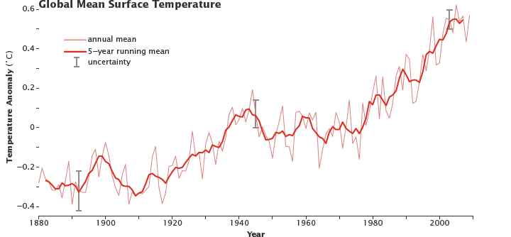
Coloradans are more concerned about water quality than about water supplies, and their awareness of the state’s looming water shortage has fallen sharply in the past three years.
Those findings are from a statewide survey on consumer attitudes about water by pollster Floyd Ciruli. The survey was commissioned by the Colorado Water Congress and the Colorado Water Conservation Board, and conducted in June with 712 respondents. Ciruli discussed the results with the General Assembly’s interim water resources review committee, which met at the Water Congress’s summer conference last week.
Ciruli compared Coloradans’ current viewpoints about water to the results of a 2013 survey. Given the state’s rampant growth and looming water shortage, the results didn’t look encouraging.
Coloradans are less concerned about whether the state will have an adequate water supply than they were three years ago. In 2013, 62 percent said they expected an eventual water shortage in the state. This year, only 53 percent shared that view. The percentage of Coloradans who think the state needs to store more water is also down from 59 percent three years ago to 50 percent this year.
The public’s diminished interest in adequate water supplies could not come at a worse time. After a two-year planning effort, Colorado water leaders are preparing for the state’s water future – a future with less water and more people. A 2010 estimate says the state will be short 326 billion gallons of water annually by the year 2050, when the state’s population is expected to nearly double from 5.4 million to 10.3 million residents. About 100,000 people are moving to Colorado every year.
Every conversation about water should start with conservation, Gov. John Hickenlooper likes to say. But what the survey shows about public interest indicates most people aren’t yet listening.
More than half of Coloradans surveyed believe their water suppliers are doing a good job encouraging water conservation, but there’s room for improvement, the survey found. More Coloradans believe that conservation alone will solve Colorado’s water shortage than three years ago, although it’s a small group – 14 percent this year compared to 10 percent in 2013.
Most Coloradans, however, believe it will take a combination of water storage and conservation to solve the shortage, although fewer believe that now than in 2013.
The survey also gauged what people know about the Colorado Water Plan – the state’s first blueprint for water planning. The 540-page plan reports that Colorado will be short one-million acre-feet of water annually by 2050. It calls for conservation measures that would help close that gap by 400,000 acre-feet, a goal primarily tasked to water utilities and other water providers…
The state plan also calls for gleaning another 400,000 acre-feet in water storage, either by improving existing dams and reservoirs or building new ones. Several projects are already under way. They include an expansion of Gross Reservoir in Boulder County, which would triple its existing capacity of 41,000 acre-feet, and the Northern Integrated Supply Project, which would capture another 40,000 acre-feet of water that currently flows downstream to Nebraska, exceeding what’s required under a multi-state contract.
The state water plan was was ordered by Hickenlooper under an executive order in 2013, with a two-year window for completion. But the plan has been criticized for being less of a plan than a snapshot of where Colorado stood on water supplies last year, and more of a compendium of ideas than specific solutions to Colorado’s water woes in an era of growth, drought and climate change.
Some water experts claim that the plan, completed last November, is already gathering dust and isn’t moving fast enough.
Dennis Saffell, a real estate broker in Summit and Grand counties, penned an editorial in June that took the General Assembly to task for failing to address key recommendations in the plan, such as conservation and funding for healthy rivers.
“With so much at stake, it is essential that the plan be implemented to build on the momentum and interest generated during its development,” Saffell wrote. He was among the 30,000 Coloradans who submitted comments on the water plan during its two-year development. “The only difficulty now is lack of engagement — letting the plan just sit — and unfortunately that’s what is occurring,” he wrote.
The legislature did pass a bill this year to put $5 million annually into implementation of the plan, although the bill wasn’t specific about just what that $5 million would be spent on. That’s left to the Colorado Water Conservation Board, which developed the plan in conjunction with nine state-directed water groups that focus on a variety of water issue.
The Ciruli survey found that very few of those polled are aware of the state water plan. Of those who were, only 4 percent knew a lot about the plan. Another 15 percent said they’d heard of it. For the rest, the plan is a mystery.
Coloradans strongly support keeping the state’s water in Colorado, the survey found. Eighty-nine percent agreed that the state should hang onto all the water it’s legally entitled to. Most respondents also were supportive of improving water conservation and building more storage, so long as it doesn’t impact the environment.
Those surveyed also responded favorably to the idea of a ballot measure in 2018 that would fund small and large storage, reuse projects and conservation programs. Coloradans were most supportive of funding long-term planning, improving water conservation programs, enhancing river habitat and developing “new water supplies,” and somewhat less enthusiastic about building new water storage…
Ciruli countered that, for most people, storage is a commonly-understood term. It’s even used in polling for environmentally-oriented groups, he noted…
Western Slope residents are concerned that the Colorado is already diverting more water than it could supply. The issue is radically different for the South Platte, which has been sending a million acre-feet of water to Nebraska each year for some time.
Respondents ranked conservation, water quality and water pollution as the top three water issues facing the state. Ciruli said the pollution issue has received greater attention in the past year due to the Gold King Mine spill in the Animas River near Durango, as well as national attention to the lead contamination in the Flint, Michigan drinking water supply. Water storage dropped from being the second most important issue in 2013 to fourth in this year’s survey.
There was tremendous support for conservation and considerable support for reuse, Ciruli said, “but the lynchpin is that respondents favored the state making a commitment to infrastructure,” in this case, water infrastructure.
The public is conscious about water and concerned about it, Ciruli said, but they want local providers to do something about it. “There’s momentum, but the public would be ill-served and not happy if the plan just goes on the shelf” and doesn’t address the problems, such as storage or maintaining agriculture, for example.
“People are ready” for the state to move on with implementing the water plan, he said.
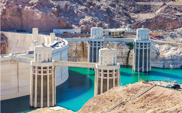
Apparently in celebration of this week’s official release date for my book Water is for Fighting Over: and Other Myths about Water in the West, Lake Mead overnight crept above the magic elevation level of 1,075 feet above sea level. That’s number attached in policy and, more importantly, the public mind to the notion of shortage on the Colorado River. At this point the elevation milestone is merely symbolic. The shortage policy, with mandatory cutbacks, only kicks in if the reservoir is below 1,075 on Jan. 1 of any given year. Mead typically rises between August and the end of the year, so there will be no shortage declaration at the end of the year.
Don’t get too excited about rising above 1,075. We’re still on track to set another one of those “lowest elevation since Lake Mead was filled” records yet again this month. The end-of-August record low is 1,078.31 which we set last year. And as Brett Walton noted this morning in Circle of Blue’s Federal Water Tap, there’s a greater than 50 percent chance of a below-1,075 shortage declaration in 2018.
As a science-policy communicator, I’m fascinated with the way “1,075” has become such a useful shorthand for a complex set of issues. The origin of its importance lies in the 2007 “Interim Guidelines for Lower Basin Shortages and Coordinated Operations for Lake Powell and Lake Mead”. The rules are complicated: every year in August, the Bureau of Reclamation runs its Colorado River Simulation System (CRSS) model, a dynamic simulation that takes current reservoir levels, projected demands and forecasts for the coming months, and estimates the elevation of Lake Mead the following Jan. 1. That estimate (and an accompanying one for Lake Powell, the big reservoir upstream) triggers a number of policy responses. If there’s a bunch of extra water in Lake Powell, we enter one of a couple of operating regimes under which what I’ve come to call “bonus water” can be released from Powell to prop up Lake Mead, a process intended to “equalize” the levels between the two reservoirs.
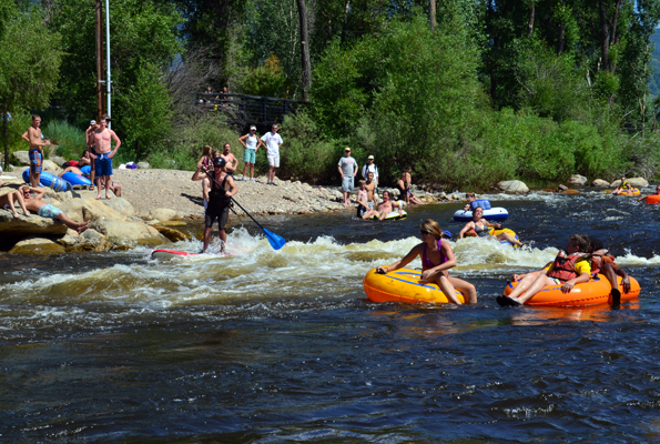
About 125 invited guests gathered for the Aug. 25 official River Run Recreational Project opening, while perhaps proof of the project’s success was the fact that there were dozens of children on the playground and dozens of enthusiasts surfing the South Platte River.
The river amenities that made surfing possible drew a lot of attention…
Nancy Doty, Arapahoe County commissioner, said during the River Run opening ceremonies the project is an example of great unified cooperation.
She said the project became a reality through the efforts of the South Platte River Working Group. The group membership is made up of individuals representing Englewood, Sheridan, Littleton, Arapahoe County, South Suburban Parks and Recreation District, the Colorado Water Conservation Board, Urban Drainage and Flood Control District and the Army Corps of Engineers.
The group’s proposals are aimed at creating more recreational opportunities along the seven miles of the South Platte River that run through Englewood, Littleton and Sheridan. River Run is the first major project undertaken and includes a playground, pavilion, trailhead and restrooms set along the eastern bank of the river. Crews have transformed and beautified both banks of the river, and paved trails provide ADA access to the banks of the river, where the chutes create whitewater for tubers, boaters and surfers.
Grants from Arapahoe County Open Space fund as well as money Englewood received from the open space fund and from lottery funds provided the roughly $800,000 needed to construct the trailhead.
Another trailhead amenity was funded recently when Great Outdoors Colorado approved Sheridan’s grant request for $350,000 to construct and equip the playground adjacent to the river…
Other river amenity projects are planned or under construction. For example, South Suburban Parks and Recreation District applied for a Great Outdoors Colorado grant to construct a walking and running trail along the east bank of the river from Union to Oxford avenues. The estimated cost of the east-side trail is about $3.3 million.
There are plans for bank enhancements along much of the seven-mile stretch as well as creation of a whitewater tubing and boating channel between West Union and West Oxford avenues. Smaller trailheads are planned at Union and Belleview avenues.
FromThe Grand Junction Daily Sentinel (Dennis Webb):
A new U.S. Geological Survey finds groundwater levels in the Upper Colorado River Basin may hold steady over the rest of this century despite a warming climate.
The revelation comes just months after another study by the same agency found that groundwater accounts for 56 percent of streamflow in the Upper Colorado basin.
The studies offer some hope of groundwater helping mitigate other water-related impacts of a changing climate in coming decades. Perhaps most importantly, groundwater could help maintain later-season streamflows at a time when snowpack runoff is expected to occur earlier in the year, resulting in additional strains on water supplies and reservoir storage during the summer months.
The climate-change study is published in the journal Geophysical Research Letters. It finds that increased precipitation predicted by climate-change models should be enough to offset the impacts of warmer temperatures on groundwater levels in the basin.
Fred Tillman, a USGS scientist and the report’s lead author, said researchers considered how groundwater outputs and inputs would be affected by climate change. Earlier snowmelt as temperatures warm will mean native vegetation greens up and begins using water through a process called transpiration earlier each year. This and more evaporation of water from soils and water bodies will increase water loss from the basin.
“We knew that we had more going out from the higher temperatures. What we found was, well, we actually had more precipitation coming in too, according to these (climate-change) models,” Tillman said.
Researchers view the base flow of streams as a proxy for the groundwater discharge into them, apart from surface flows from snowmelt and rain.
Eric Kuhn, general manager of the Colorado River District in Glenwood Springs, said one thing water managers have been concerned about is that future late-summer base streamflows will be extremely low as the climate changes. He said he hasn’t yet read the new study, but it may be that groundwater levels will hold up better than expected due to higher precipitation.
“Perhaps the late-season, low-flow period will not be as bad as we once thought it would be,” he said.
“With a little more groundwater it offers a little more help” late in the season, Kuhn said.
However, Kuhn also said climate models generally suggest that precipitation will increase in the basin in more northern and eastern regions, while dropping off to the south and west.
Tillman noted the same thing, and said a follow-up study by the Geological Survey will break down its groundwater projections by sub-regions, and will likely show that some sub-regions to the south will show losses in groundwater, while some in the north will gain.
The study also doesn’t try to factor in how changes in future land use and human activities could affect groundwater levels, something Tillman said would require accounting for a whole other set of projections. Kuhn said increased transpiration will occur not just for native vegetation but things such as lawns, parks and crops.
The river district has been involved with another study on how vulnerable Lake Powell may be to drought in coming decades. Upper Colorado River Basin states rely on water stored in the reservoir to meet water delivery obligations to downstream states under an interstate compact, so they can avoid a so-called compact call that would affect water users in Colorado. Powell also is a sizable source of hydroelectric power in the region.
Kuhn said that while average precipitation may go up in the region, climate models also suggest a warming atmosphere would lead to more severe dry and wet periods. The preliminary findings of the study the river district is leading are that another drought like the one that occurred in the early 2000s could empty Powell if it’s half-full, as is now the case.
As water officials try to figure out how to address future supplies, Geological Survey researchers believe the findings of their studies point to the importance of thinking about surface water and groundwater in the Upper Colorado basin as a single resource, and managing water accordingly. Tillman said hydrologists know that generally speaking, groundwater and surface water are all the same water, originating from precipitation, but it’s good to get that message out.
He said researchers on the two Geological Survey studies weren’t working together, but their results dovetail in terms of helping people understand the importance of groundwater in the basin and then looking at how that groundwater might change in the future.
The earlier study evaluated water chemistry and streamflow data at 146 sites to help separate out what role groundwater plays in streamflows in the basin. It found that a greater percentage of streamflow is from groundwater lower in the basin, with a greater percentage of snowmelt and precipitation directly contributing to streamflows in the high-elevation headwaters.
It also estimates that 82 percent of groundwater that discharges to streams in the basin is lost to factors such as evaporation, plant transpiration and water diversions, and it points to the threat that groundwater pumping poses to groundwater levels.
Kuhn said that in Colorado, almost all groundwater in the Colorado River basin is considered tributary groundwater that originates as snow and ice and rain and makes its way out of the ground and into streams within months or years. Such groundwater is different from deep groundwater supplies in places like eastern Colorado, and Kuhn said that from a management perspective, tributary groundwater already is subject to surface-water-type appropriation laws in the state.
“That groundwater, basically it is Colorado River water,” he said.
Photo: The commissioners of the Republican River Compact Administration sign the long-term resolutions on August 24: (from left) Commissioner David Barfield, Chief Engineer, Kansas Department of Agriculture; Commissioner Dick Wolfe, State Engineer, Colorado Division of Water Resources; Commissioner Jeff Fassett, Director of Nebraska’s Department of Natural Resources, via Governor Hickenlooper’s office.
Here’s the release from Governor Hickenlooper’s office:
Gov. John Hickenlooper today announced Colorado, Kansas and Nebraska established an agreement this week in the longstanding conflict over water from the Republican River basin, as the Republican River Compact Administration signed two resolutions.
Representatives from the three states have been meeting monthly for over two years, in an effort to change the approach and improve how they manage interstate water matters. This effort has created a new focus on transparency and certainty as all three states work to serve their water users. The intent of these resolutions is to replace the need for annual reviews and instead provide long-term surety to water users.
“We are proud to be part of this historic agreement,” said Hickenlooper. “For the first time since signing the Compact, the three states have worked together to resolve their issues without litigation and have brought certainty to the water users in the basin. This is how we do our best work in Colorado and defines our approach to addressing our water challenges — cooperation and collaboration.”
“Signing these resolutions shows the commitment from all three states to engage in open and transparent dialogue for the past two years,” said Kansas Governor Sam Brownback. “This long-term agreement will ultimately improve water management for water users in Kansas as well as Nebraska and Colorado.”
The resolutions signed this week will provide flexibility and greater certainty to all water users in the region, while remaining consistent with the terms of the Republican River Compact and the Final Settlement Stipulation of 2002. The three states have been involved in various litigation and arbitration for the past 15 years over administration of water in the Republican River basin, and this agreement is a significant and positive step forward, with the next steps focusing on working with the basin’s water users to implement these agreements.
“It has been a priority of the states to collaborate on interstate water matters to ensure each state’s water users are protected while also maintaining a positive working relationship between the compacting states. “These resolutions represent a long-term strategy for representing each state and ultimately improving water management for water users in all three states,” said Nebraska Governor Pete Ricketts.
The Republican River basin begins in the plains of eastern Colorado and flows through northwest Kansas and southern Nebraska, ultimately returning to Kansas. The Republican River Compact was negotiated during the early 1940s with participation by the states of Colorado, Kansas and Nebraska and a representative of the President of the United States. The Compact was formally signed in 1942. Its purposes are to provide for equitable division of such waters, remove all causes of controversy, promote interstate comity, promote joint action by the states and the United States in the efficient use of water and the control of destructive floods, and provide for the most efficient use of waters in the Republican River basin.
The state official in each of the three states who is charged with administering water law serves on the Republican River Compact Administration. For more information about the Compact, go to the following websites:
They are a big part of the Colorado Water story, with a long tradition in the state. Hundreds of ditch riders work every day to make sure needed water gets to farms and ranches, among other places.
In the quiet reflection of the morning is where ditch rider Randy Ebert does much of his work every day, to make sure a precious resource keeps flowing across Colorado.
“There’d be a lot of dry land around here without the water,” he said. “I mean, there’s a lot of it right now.”
He works for the Farmers Independent Ditch Company, which ensures water rights are properly administered to their clients through the flow of water.
“If they order water in, I open it up, give them their share of the water,” Ebert said…
“It’s really rewarding when you drive around and see the crops that you delivered water to and then the guys work hard to raise and they do a great job of it with what they have,” he said. “It’s really rewarding.”
On U.S. Geological Survey expeditions through the American West in the 1870s, William Henry Jackson took the first photographs of the Yellowstone region’s thermal springs, craters and geysers. Those images helped persuade Congress to protect Yellowstone as a national park — America’s first — in 1872. Jackson also took early pictures of Yosemite in California and Wyoming’s Devils Tower, and was the first to photograph the ancient cliff dwellings at Colorado’s Mesa Verde, decades before it became a national park. Long before color film was available, he used the photochromic process to colorize black-and-white photos, which he sold as postcards. To celebrate the National Park Service’s 100th birthday this month and Jackson’s role in its history, his rare photographs will be displayed at the FAD Gallery in Mancos, Colorado, until the end of September. The exhibit showcases 10 original black-and-white postcards of Mesa Verde and over a dozen vivid color photos of other Western landmarks.
William Henry Jackson Photos, Exhibit of rare, original photochromes and cabinet cards at FAD (Furniture, Art & Design) Gallery, 107 Grand Ave., Mancos, CO.
Another pool of melt water over sea ice, as seen from an Operation IceBridge flight over the Beaufort Sea on July 14, 2016. Scientists have found that formation of melt ponds early in the summer reduces the ability of sea ice to reflect solar radiation, which leads to more melt. Credit: NASA/Operation IceBridge.
The darkest prognosis is that bio, cyber or environmental catastrophes could foreclose humanity’s potential. But there is an optimistic option.
…suppose some aliens had been viewing our planet for its entire 4.5bn-year history. What would they have seen?
Over nearly all that immense time, changes would have been very gradual: continents drifted; the ice cover waxed and waned; successive species emerged, evolved and became extinct during a succession of geological eras.
But visible change has accelerated rapidly in the past few thousand years – a tiny sliver of the Earth’s history. Now geologists have decided those changes have been so profound, so global and so permanent that our catalogue of the Earth’s history needs to change accordingly. Since the last ice age, around 11,000 years ago, human civilisation has flourished in the climatically benign Holocene. Now they believe that epoch has come to an end and we have entered a new human-influenced age, the Anthropocene.
The changes that our aliens could observe from space are not hard to spot. In just the last few thousand years, the patterns of vegetation altered much faster than before. These human-induced changes signalled the start of agriculture.
And human activity manifested itself in other ways that will leave traces in the geological record. Constructs of concrete and metal sprawled across the continents; domesticated vertebrates numerically overwhelmed wild ones; the carbon dioxide in the atmosphere rose anomalously fast; traces appeared of plutonium and other “un-natural” substances.
The imaginary aliens watching our world would have noticed something else unprecedented in geological history. Rockets launched from the planet’s surface escaped the biosphere completely. Some were propelled into orbits around the Earth; some journeyed to the moon and planets.
What do these trends portend? Should we be optimistic or anxious? It’s surprising how little we can confidently predict – indeed, we can’t predict as far ahead as our forebears could. Our medieval ancestors thought the Earth was only a few thousand years old, and might only last another thousand. But they didn’t expect their children’s lives to be very different from theirs. They built cathedrals that wouldn’t be finished in their lifetime.
Our time horizons, both past and future, now stretch billions of years, not just thousands. The sun will keep shining for about another 6bn years. But ironically we can’t forecast terrestrial trends with as much confidence as our ancestors could. Their lives and environment changed slowly from generation to generation. For us, technological change is so fast that scenarios quickly enter the realm of wild conjecture and science fiction.
But some things we can predict, at least a few decades ahead. By mid-century, the world will be more crowded, and our collective footprint will be heavier. World population is now 7.2 billion and is forecast to rise to around 9 billion by 2050. Experts predict continuing urbanisation – and huge growth of megacities such as Lagos, São Paulo and Delhi. Population trends later this century depend largely on what happens in Africa, where some UN predictions foresee a further doubling between 2050 and 2100.
Moreover, if humanity’s collective impact on nature pushes too hard against what Johan Rockstrom calls “planetary boundaries”, the resultant “ecological shock” could irreversibly degrade our biosphere. And if global warming reaches a tipping point that triggers melting of Greenland’s ice, coastlines a millennium hence would be drastically different. Extinction rates are rising. We’ve only identified about two million of the (estimated) 10 billion living species: we’re destroying the book of life before we’ve read it. To quote the great ecologist EO Wilson, “mass extinction is the sin that future generations will least forgive us for”.
The darkest prognosis for the next millennium is that bio, cyber or environmental catastrophes could foreclose humanity’s immense potential, leaving a depleted biosphere. Darwinian selection would resume, perhaps leading, in some far-future geological era, to the re-emergence of intelligent beings. If this happens, or if there are aliens out there who actually visit and study the Earth, then, digging through the geological record (and applying archaeological techniques as well) they would uncover traces of a distinctive transient epoch, and ponder the all-too-brief flourishing of a species that failed in its stewardship of “spaceship Earth”.
But there is an optimistic option.
Human societies could navigate these threats, achieve a sustainable future, and inaugurate eras of post-human evolution even more marvellous than what’s led to us. The dawn of the Anthropocene epoch would then mark a one-off transformation from a natural world to one where humans jumpstart the transition to electronic (and potentially immortal) entities, that transcend our limitations and eventually spread their influence far beyond the Earth.
Even in a cosmic time-perspective, therefore, the 21st century is special. It marks our collective realisation that the Anthropocene has begun – and it’s a century when human actions will determine how long that epoch lasts.
From left, President François Hollande of France; Laurent Fabius, the French foreign minister; and United Nations Secretary General Ban Ki-moon during the climate change conference [December 2015] in Le Bourget, near Paris. (Credit Francois Mori/Associated Press)
Chris Woodka, a longtime editor and reporter at The Pueblo Chieftain, recently accepted the position of issues management program coordinator for the Southeastern Colorado Water Conservancy District, effective Sept. 12. He will work with the district and Bureau of Reclamation on the Arkansas Valley Conduit and other projects.
Woodka, 61, has worked at The Chieftain since 1985. For the past 12 years, he has been on special assignment as a water reporter, as well as filling various relief roles for other editors and reporters. Over the years, he has received numerous awards from newspaper associations and various community groups.
Woodka will continue to write Monday Morning Special, which appears weekly in The Chieftain’s Life section.
Click here to read the Coyote Gulch post about Chris from Matt Jenkins writing in The High Country News: From the post:
…Woodka, 57, is Colorado’s sole remaining full-time water reporter. He has worked hard to separate himself from the Chieftain’s editorial slant, and has built a reputation for his fair coverage of an extremely complicated and contentious subject. “You kind of make your own luck,” Woodka says. “Your sources have to be good, and you don’t burn them.”
Steve Henson, the Chieftain’s current managing editor, serves as a deliberate editorial firewall between Woodka and the publisher’s suite. “I kind of make my own assignments,” Woodka says. “Steve will let me know the publisher’s concern, and what the publisher would like to see in the story.”
“But,” he adds, “that’s not always the story that he gets.”
Click here to view all the Coyote Gulch posts with Chris in the text and click here for posts from the old blog — 2003 to February 2009.
A recently constructed interpretive pullout off U.S. Highway 160 east of Cortez showcases the wooden irrigation flume, which was built in the 1890s to deliver water to the Ute Mountain tribe and pioneer farms.
The restoration grant requires a $60,000 match, and a fundraising effort is underway. Once that is raised, the flume’s main wooden trough structure will be repaired and restored, completing the multiyear project.
“Right now, people will stop at the interpretive pull-off and see that the flume needs repair, and that is what this grant will be paying for,” Towle said, adding that as much original wood as possible will be used in the restoration.
Repairing the foundation was the priority. In 2014, a $123,000 state historical grant was awarded to the county to rebuild the foundation and stabilize the structure to withstand flows in McElmo Creek. That foundation work was completed in February.
The paved highway pullout, parking lot, interpretive panels, information, kiosk, sidewalk and flume overlook were made possible by $250,000 in funding allocated by the National Scenic Byways Program in 2013.
The historic flume is an agricultural artifact that symbolizes the beginning of the city of Cortez and surrounding communities, Towle said.
“Cortez would not be here without these first irrigation systems,” she said. “It is important for visitors coming through to learn the story about how the efforts of early farmers and ranchers grew the town and got us to where we are today.”
Final interpretive panels on water history are still being created for the flume overlook. Also a regional tourism map will be installed at the kiosk highlighting local attractions.
Throughout the project, contributions have been made by many agencies and organizations, including Montezuma County, Southwestern Water Conservation District, Southwest Roundtable, Montezuma Valley Irrigation Company, Dolores Water Conservancy District, and the Ute Mountain Tribe. The Colorado State Historical grants awarded for the project are derived from a portion of gambling revenues in Cripple Creek, Central City, and Black Hawk.
The timing of the three-day summit at the Colorado Convention Center in Denver was appropriate, given two proposals that could be approved or rejected for the November ballot as early as next week.
One proposal would allow local governments to overstep the state’s regulatory authority to enact stringent rules, including bans on fracking.
The second proposal would increase setbacks of wells from schools, hospitals and homes from 500 feet to 2,500 feet.
The industry has said that effort would put 95 percent of land in the top five oil-and-gas-producing counties in Colorado off limits. La Plata County would become almost completely barred from development, as 99.6 percent of land would be prohibited.
Gov. John Hickenlooper, a Democrat, supports fracking, and he has concerns with the two ballot proposals. In 2014, he struck a deal that kept initiatives off the ballot. The compromise was that a task force would meet to address the local control issue.
But the task force largely fell short in the eyes of industry opponents. The rule that came out of it requires operators to consult and register with local governments when building large facilities. But it did nothing to extend powers to local governments.
The Colorado Supreme Court in May ruled that state power trumps local rules and regulations, which has caused some local governments – including Boulder County – to re-examine moratoriums on oil and gas development.
But with groups continuing to push ballot proposals, the issue has so far not gone away.
Hickenlooper believes education and stakeholder processes have quelled some concerns. He doubts proponents will make the ballot this year, as groups submitted about 100,000 signatures per proposal to the secretary of state’s office. It takes 98,492 valid signatures to make the ballot, so there’s not much of a cushion.
“People get so swept up in the emotion of the moment and carried away by some image, or a fact, that turns out not to be a fact,” Hickenlooper said while speaking during a panel discussion at the summit. “What we should spend a lot of time trying to do is make sure the right information is out there…
Federal regulations and politics
Even if the state enacts its own standards, much of the burden falls on federal regulators, which has tied into elections and politics.
The U.S. Chamber of Commerce floated a report at the energy summit that stated that a ban on energy production on federal lands would cost Colorado 50,000 jobs, $124 million in annual royalties and $8.3 billion in gross domestic product.
Former Democratic challenger Bernie Sanders forced Hillary Clinton and the Democratic Party further to the left on the oil and gas issue, moving them closer to a “keep it in the ground” platform.
The Clinton campaign says it is not pushing for a ban, just that “our long-term goal should be no extraction of fossil fuels on public lands.”
Proposals include reforms to fossil fuel leasing, a continued review of the federal coal program, prohibitions on development in the Arctic and Atlantic oceans, raising royalty rates and ensuring that new leasing accounts for the clean energy market.
In Colorado, the business world is concerned about the transition…
U.S. Sen. Michael Bennet, a Democrat who is running for re-election this year, took a more middle-of-the-road approach.
“Colorado truly is a state that can embrace all energy sources …” Bennet said. “Colorado is particularly well positioned to have these markets because of industry-led efforts to protect Colorado’s air and water.”
The growth of solar and wind energy related jobs could easily absorb coal industry layoffs over the next 15 years and provide full-time careers, if investments are made to retrain workers, according to a new study by researchers at the Oregon State University and the Michigan Technological University.
Edward Louie, the report’s co-author, says between solar and wind, Utah is in a good position to become more energy independent and a leading exporter of renewable power.
“To transport the wind blades, to install the wind turbines – and then also all the jobs it would take to upgrade the transmission lines to handle that high percent of renewables – then there’s more than enough positions,” he explains.
Louie notes coal jobs have become increasingly at risk because of falling natural gas prices and new Environmental Protection Agency rules targeting coal-fired power plants to limit climate pollution.
He says if the U.S. goes completely renewable, nearly 1,400 Utah workers – and 75,000 nationally – will need to find new jobs.
The solar industry already employs more than 200,000 people and is creating jobs 12 times faster than the overall economy, according to the study, which also determined closest equivalent solar positions and salaries.
Louie says a coal operations engineer, for example, could retrain to be a manufacturing technician in solar and expect about a 10 percent salary increase.
“Obviously there are some jobs that are very specific to coal mining, and those workers will probably need some retraining to find a job in the renewable energy industry,” he says.
The study also found that a coal CEO’s annual salary would be more than enough to retrain every company employee for a job in renewables.
Louie adds other possible funding sources include federal and state dollars, and he says coal workers also could choose to pay for training themselves.
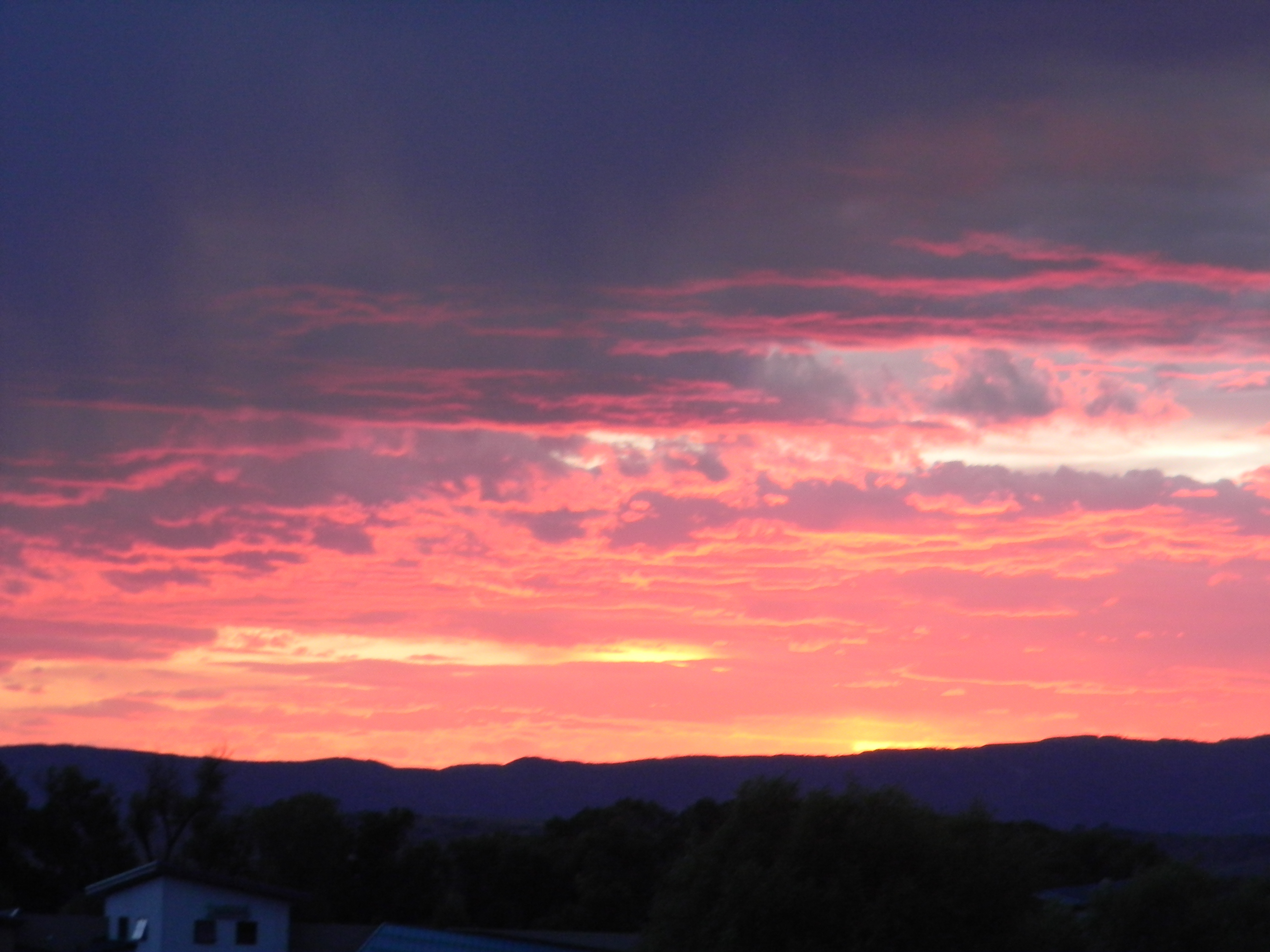
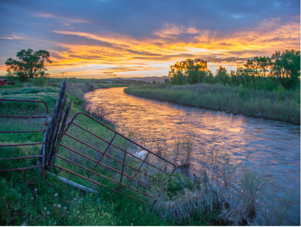
Sunset over the Yampa River Valley August 25, 2016.
I was roughing this week in Steamboat Springs at the Colorado Water Congress’ 2016 Summer Meeting. It was a full agenda along with appearances from Senator Bennet, Senator Gardner, Representative Tipton, former State Senator Gail Schwartz, and Senate candidate Darryl Glenn.
I think the Colorado mountains inspire good will and friendliness. Doug’s agenda provided breaks long enough for attendees to network, catch up, and learn about each other. I ran into a guy whose firm has done some VIC modeling as I aspire to do.
The highlight for me was a walk around the Yampa River Botanic Park. Marsha Daughenbaugh from the Community Agriculture Alliance walked us through the history of the county focusing on agriculture. The Routt County economy is dependent on Steamboat Resort of course, but thousands of acres are still producing hay, barley, wheat and pasture for cattle and sheep. We talked about the administration of rivers by the State Engineer’s Office. She had read Brent Gardner-Smith’s recent account on the subject.
Sen. Michael Bennet this morning made a pitch to the state’s water community for sending him back to Washington, despite the rank partisanship that characterizes Congress these days.
Colorado’s senior senator spoke this morning to 340 water leaders attending the summer conference of the Colorado Water Congress in Steamboat Springs.
In prepared remarks, Bennet cited his bipartisan efforts on immigration, the farm bill and education, and touted his ability to work across the aisle with Republican senators such as Cory Gardner of Colo., Roy Blunt of Missouri and Lamar Alexander of Tennessee.
He also spoke about the continued efforts to clean up the Gold King mine disaster in Durango, stating that when it comes to water issues, the federal government should “do no harm,” although the Environmental Protection Agency caused the Gold King leak. The efforts of the local community trying to protect its tourism industry have been impressive, he said, and as a result the Durango area’s economy is doing well.
Bennet pledged to continue to push the EPA to reimburse the community and the tribes for the damage. He also will continue to work on legislation with Gardner and Rep. Scott Tipton of Cortez on so-called “Good Samaritan” legislation that would allow mine cleanups without fear of lawsuits. “The spill was a reminder that there are thousands of abandoned mines across the West,” yet the nation’s mining law dates back to 1872. That’s also legislation that he’s working on with New Mexico lawmakers.
Bennet also took aim at those in Washington who are more interested in playing politics than in making constructive change.
“What we’ve lost in Washington is the ability to have these differences in a way that’s constructive for the country,” he said.“It’s inexcusable. We have a moral responsibility to make sure we’re moving this country ahead.”
In a free-flow question and answer session after his speech, Bennet took off the gloves and talked at length about what frustrates him most: Congress’s broken culture and its inability to do anything.
He started off by noting a poll that showed only 9 percent of Americans approve of the job Congress is doing, and comparing it to other things that have higher approval than 9 percent: the Internal Revenue Service (40 percent), reality TV star Paris Hilton (15 percent) and the percentage of people who want the United States to turn communist, at 11 percent.
While he believes Congress is hamstrung by partisanship, Bennet also said that some of those who say Congress is broken “are the arsonists lighting the house on fire.” Their fuel, he added, comes from both sides of the aisle.
At times Bennet appeared exasperated – not at the audience, but at the partisan problems he says infest the nation’s capitol, a city where he grew up. It was an unscripted Michael Bennet, one who momentarily stood with his hands on his hips, shaking his head.
Bennet cited a Democratic caucus lunch in which a senior Democrat (he didn’t name names) pointed to the lead poisoning crisis in Flint, stating that the crisis is “what separates us from them. We believe in government, they don’t.” Bennet said he realized some of the decisions were made by a Republican governor, but in the end it was government as a whole that’s culpable. Even before the water crisis, there isn’t a single school in Flint where any senator would send their kids. “This can’t be what divides us.”
Bennet said he has tried to work with his Republican colleagues – such as Sen. Richard Burr of North Carolina on improving the approval process of the Food and Drug Administration. Before that legislation, the FDA would approve 1 or 2 drugs per year. But in the past four years the FDA has green-lighted 50.
Bennet also gave a strong defense of the science backing man-made climate change. He noted polls of independent voters who overwhelmingly say they would be less likely to support someone who denies that climate change is real and/or caused by people. It was a subtle dig at his Republican opponent, El Paso County Commissioner Darryl Glenn, who has said he’s skeptical of man-made climate change.
The time has come to adopt policies at the national level to prepare for climate change before the trend becomes unfixable, Bennet said. Colorado’s economy is already threatened by climate change, such as increasingly extended fire seasons and the threats wildfires pose to forests and the state’s water supply.
“I’m optimistic,” Bennet said. There are real opportunities to get results for Colorado and the nation. “The public is sick and tired of rank partisanship,” and Bennet said he hopes that this year’s election creates political momentum for that to change.
And “if the election goes the way many think it will go, I hope it will incentivize the Republican party to put the capitalists back in charge,” he said.
“I wouldn’t go back if I didn’t think we could improve it.”
Bennet recalled a town hall held in the “worst tea party town in the state” (which he didn’t identify), with people calling him a socialist, and claiming President Obama wasn’t born in the United States.
That kind of partisan politics has made it impossible to fix the real problems, he said. “We don’t have the decency to maintain the assets and infrastructure that our parents and grandparents had the decency to build for us.”
Bennet encouraged the audience, who sat mostly silently during the remarks, to hold their congressional representatives accountable in the same way citizens hold local officials accountable. “If we hold Washington to the same standard” as mayor, city council or school superintendents, “there’s no way we’d be having the problems we’re having, and there’s no way you would shut down the government for politics.”
The only antidote to partisan politics is to vote out of self interest, state interest and in the interest of the country.
“If we do that we’ll be fine,” he said. “If we leave it to Washington to play the political game, there’s no reason for optimism.”
Sen. Michael Bennet touted his own record of bipartisanship on Colorado water issues at the summer convention of Colorado Water Congress, while his challenger Darryl Glenn stressed government accountability.
“I’ve worked with the other side and seen results. I think the public is sick and tired of partisanship,” Bennet, a Democrat, said. “What people want is principled bipartisanship. What they get is unprincipled partisanship.”
Glenn said there is room for disagreement, but there needs to be more respect in national politics.
“There’s a growing disconnect with what’s happening at the federal level and what the people at home are thinking,” said Glenn, a Colorado Springs Republican. “I have to remind people that we (in government) work for you, and you have to hold your elected officials accountable.”
Bennet talked about the local efforts to rebound from last summer’s Gold King mine spill, which he toured with Republican Sen. Cory Gardner.
“We are working together for Good Samaritan legislation so that cleanup can happen without fear of liability,” Bennet said.
Bennet talked about protecting agriculture, tourism, West Slope industry and East Slope diversions from the Colorado River. He also said the federal government needs to act on wildfire prevention and stop diverting watershed improvement funds to fight fires.
“There are eight wildfires in Colorado. . . . We’d be better off maximizing our ability to get timber off the land,” Bennet said. “It is fiscally irresponsible to not pay $1 for prevention to avoid paying $10 for fighting fires.”
He also spoke of the need to repair aging water delivery systems.
“Because of the politics in Washington, D.C., we don’t have the decency to repair the infrastructure that our parents had the decency to build for us,” Bennet said.
Glenn talked about his own experience dealing with water issues on a local level. He was a member of Colorado Springs City Council during the formative years of the Southern Delivery System and an El Paso County commissioner when the Black Forest Fire destroyed 14,000 acres and nearly 500 homes.
Those experiences gave him insight into regional water concerns and reinforced his view that constituents have to ask government for the services they need.
“More control needs to be into the elected officials’ hands and not the (federal) agencies,” Glenn said. “Sometimes we need to get out of your way and let you do your jobs.”
The opponents differed on the impact of federal overreach on laws like the Clean Water and Endangered Species acts.
From Bennet’s point of view, issues would be better managed if the federal government would listen more to local concerns. Glenn said agencies ignore the intent of laws altogether because they lack clarity of purpose.
Rep. Scott Tipton renewed his pledge to knock back federal regulatory overreach at every opportunity at the Colorado Water Congress summer conference.
The Republican’s Democratic challenger, Gail Schwartz, said she would reach across the aisle to protect Colorado’s resources and interests in Congress.
Both candidates stopped by the conference to make their pitch and answer questions at a meeting of a statewide group.
The 3rd Congressional District encompasses most of the Colorado River basin, as well as some of the Arkansas River, and all of the Rio Grande and North Platte River watersheds in Colorado. Pointedly, it was the only congressional race on the menu for those at the conference.
Tipton, seeking his fourth term, was stringent on the need to keep the federal government from meddling in Colorado water affairs. He said last year’s Gold King mine spill caused by the Environmental Protection Agency was an example of the failure to seek local technical expertise. He railed against federal policies such as Waters of the United States and Forest Service ski area contracts that would have required assignment of water rights.
He is backing a Separation of Powers Restoration Act to keep the executive branch from continually interfering.
“These are federal policies that don’t get voted on,” Tipton said. “It takes a proverbial Act of Congress to undo a federal policy that no legislator, Democrat or Republican, has ever voted on.”
Schwartz, who left the Colorado Senate after eight years, vowed to protect the agriculture, watershed health and natural resources of Colorado, and said she would seek solutions.
“One of the challenges is: How do we develop a process that sorts out all of the competing issues?” she said.
The candidates had common ground on questions posed by Water Congress.
Both said the state’s viewpoint, sound science and technical expertise need to be a part of how federal programs like the Clean Water Act and Endangered Species Act are implemented. Schwartz, like Tipton, said the administration has to be held accountable for its policies. And both support including coal as part of a national energy strategy.
“Steel is a critical industry for Colorado, and (EVRAZ) is the largest energy user in the state,” Schwartz said, pointing out that a large coal-fired plant was constructed near the Pueblo plant for that reason. Coal mining and electric-generation are part of the state’s economic fabric.
“Let the free market answer these questions moving forward,” she said.
Tipton talked about looking into the eyes of a mother whose family lost its income and commiserating with Routt County commissioners over the loss of tax revenue when Peabody Coal declared bankruptcy this year.
“We have an opportunity to do all of the above (coal, gas, solar, wind, hydropower) and not pick winners and losers,” Tipton said.
Tipton circled back to regulation by the end of his presentation, saying federal regulations add $2 trillion a year in costs. While some regulation is necessary, much is not, in his view.
“We need opportunity and not to have the government choking off that opportunity with excess regulations,” he said.
Schwartz said she would be better able to work with others in Congress to protect the state.
“How do we go back to Washington and get something done?” she said. “I’m determined and won’t be daunted by partisanship.”
Reengineering the permitting process for water projects is a central concern for water providers, the Colorado Water Conservation Board, and some environmentalists. Here’s a report from Chris Woodka writing for The Pueblo Chieftain:
The people who want to build dams or water projects say the regulatory process adds millions of dollars and years of time.
Those who object to water projects say they are either old and gray or young and green by the time anything gets done.
So nobody’s complaining too much about Colorado’s Water Plan looking at using an efficiency plan called the lean manufacturing model to streamline permits for water projects.
The lean model has its roots in private industry as a way to eliminate waste along the manufacturing line, explained James Eklund, director of the Colorado Water Conservation Board. Along those lines, several proponents, opponents and regulators were “locked in a room for three days” to determine what’s wrong and how to fix it.
“Permitting is far and away the most challenging part of any project,” said Eric Wilkinson, executive director of the Northern Water Conservancy District. “Engineers can solve everything, but not the political and social issues. We need to find a way to ‘yes.’ ”
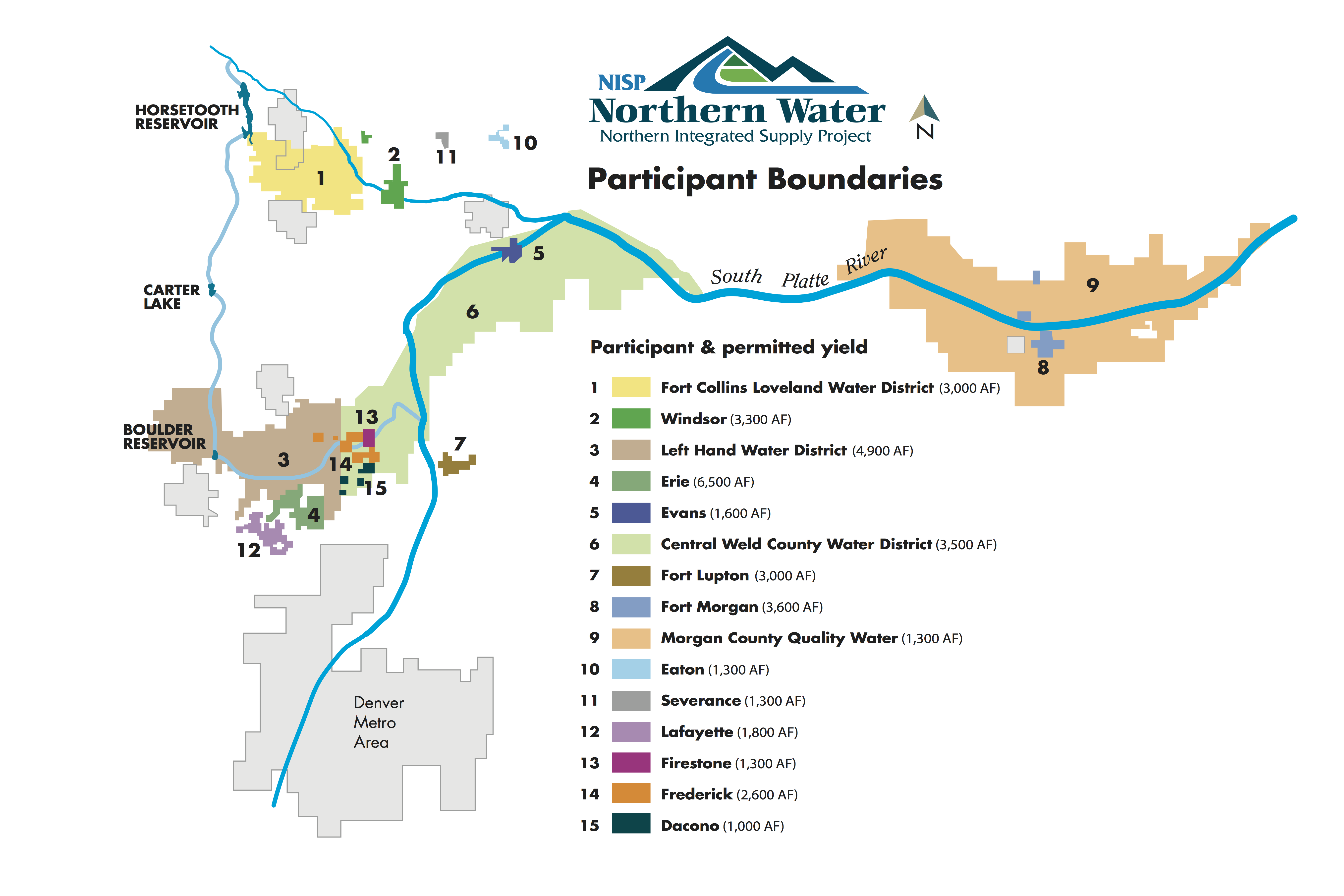
Northern is working on two projects, the Windy Gap firming project and Northern Integrated Supply Project, which combined have consumed two decades and $30 million just to get through permitting.
“Permitting is not for the weak of heart. It’s for the stubborn,” Wilkinson said.
Mark Pifher shepherded Aurora’s Prairie Waters and Colorado Springs’ Southern Delivery System through the permitting maze, and he had a long list of things that could be fixed on local, state and federal levels.
“We can’t have fear of litigation drive the process,” he said.
Ken Neubecker, director of Colorado River basin programs for American Rivers, said the review processes already in place have yielded good results. But he, too, would like to see things move more quickly.
“At first there’s scoping, then it goes into a black hole for four or five years and you have a draft analysis. We have 30 days to comment, then it disappears into another black hole,” he said. “We’re frustrated with the costs and scrambling to find funding. You lose people (who worked on original documents).”
Still, federal laws like the National Environmental Policy Act, Clean Water Act and Clean Air Act have worked and made the country a better place to live, Neubecker said.
Shaun McGrath, head of the EPA’s Denver office, said the laws aren’t really the problem, just the way they are implemented.
“One of the impediments has been the lack of stakeholder involvement at the beginning of the process,” McGrath said.
Environmental reviews also search for alternatives that might be less damaging as a way to inform the public, not inhibit development, he said. NISP and Windy Gap have taken so long because there is so much to look at.
Meanwhile, Colorado farmers are cozying up to farming their water via leasing. Here’s a report from Chris Woodka writing for The Pueblo Chieftain:
Colorado farmers have little interest in selling their water, but if the terms and conditions were right wouldn’t mind leasing some to thirsty cities.
Those were the findings of a survey conducted this year by the Colorado Cattlemen’s Association, asked of farmers across the state with farms of varying sizes.
“Our goal is to keep ag water connected to ag lands and that means keeping the water in the hands of ag producers,” Terry Fankhauser, executive vice-president of the CCA, told the Legislature’s interim water resources review committee Wednesday. “These are longer term decisions that take more than a few years.”
The committee was meeting at the annual Colorado Water Congress summer convention.
The survey was explained by Phil Brink, director of the Agriculture Water Network, which conducted the study for CCA and other groups concerned about the future of farming.
Colorado is growing by a population of 100,000 annually, the equivalent of a city the size of Longmont, that would require 17,000 acre-feet of water, Longmont’s annual consumption, Brink said.
Colorado’s Water Plan estimates that by 2050, nearly 10 million people will live in the state. Without alternatives, 500,000-700,000 acres of farmland could be dried up.
Farmers don’t want that to happen.
According to the survey, about one-third of farmers are not interested in leasing or selling their water under any conditions.
Less than 1 percent said selling is the most appealing option.
About 20 percent said they would participate in a water leasing program if offered the chance immediately, while 40 percent would consider one, if the terms were right.
Most of those who favor leasing prefer a program, such as the Arkansas Valley Super Ditch, that allows them to control how much ground is fallowed and when in order to lease water.
But they also want programs to be carefully structured because of concerns about leasing.
In comments, some farmers mentioned that crop prices are now low, making leases more attractive, but they would want the opportunity to use water for crops once prices rebound. Farmers were most likely to lease for prices between $400-$800 an acre, or about $500 per acre-foot. The amounts differ because most ditches apply more than an acre-foot per acre in most years.
Other concerns included the perception that if a farmer could do with less water, that might become accepted as the norm, and water rights would be diminished.
The results of the survey will be posted online, and workshops in each basin are planned to further explain the survey.
Click here to view the Tweets posted with the hash tag #cwcsc16. These meetings are turning into Twitter fests.
Chris Woodka was telling folks at the meeting that he is moving on from the Chieftain to the Southeastern Colorado Water Conservancy District. Man, I am going to miss him writing about water. He has taught me so much. Good luck Chris.
The first phase of the new park at the South Platte River near the Broken Tee Golf Course in Sheridan off of West Oxford Avenue officially opens Thursday.
It is crunch time for construction crews as they put the finishing touches on the new park with its beaches, sprawling landscape, event venue and two man-made surf spots.
The $14 million project is part of a one-mile revamp of the river with the goal of turning the unused urban waterway into something special. The publicly-funded project is being paid for through a partnership with the Urban Drainage and Flood Control District, Arapahoe County, City of Englewood, City of Sheridan, South Suburban Parks and Recreation and the Colorado Water Conservation Board.
Besides the new open space and recreation area, flood control structures were replaced and the river banks stabilized.
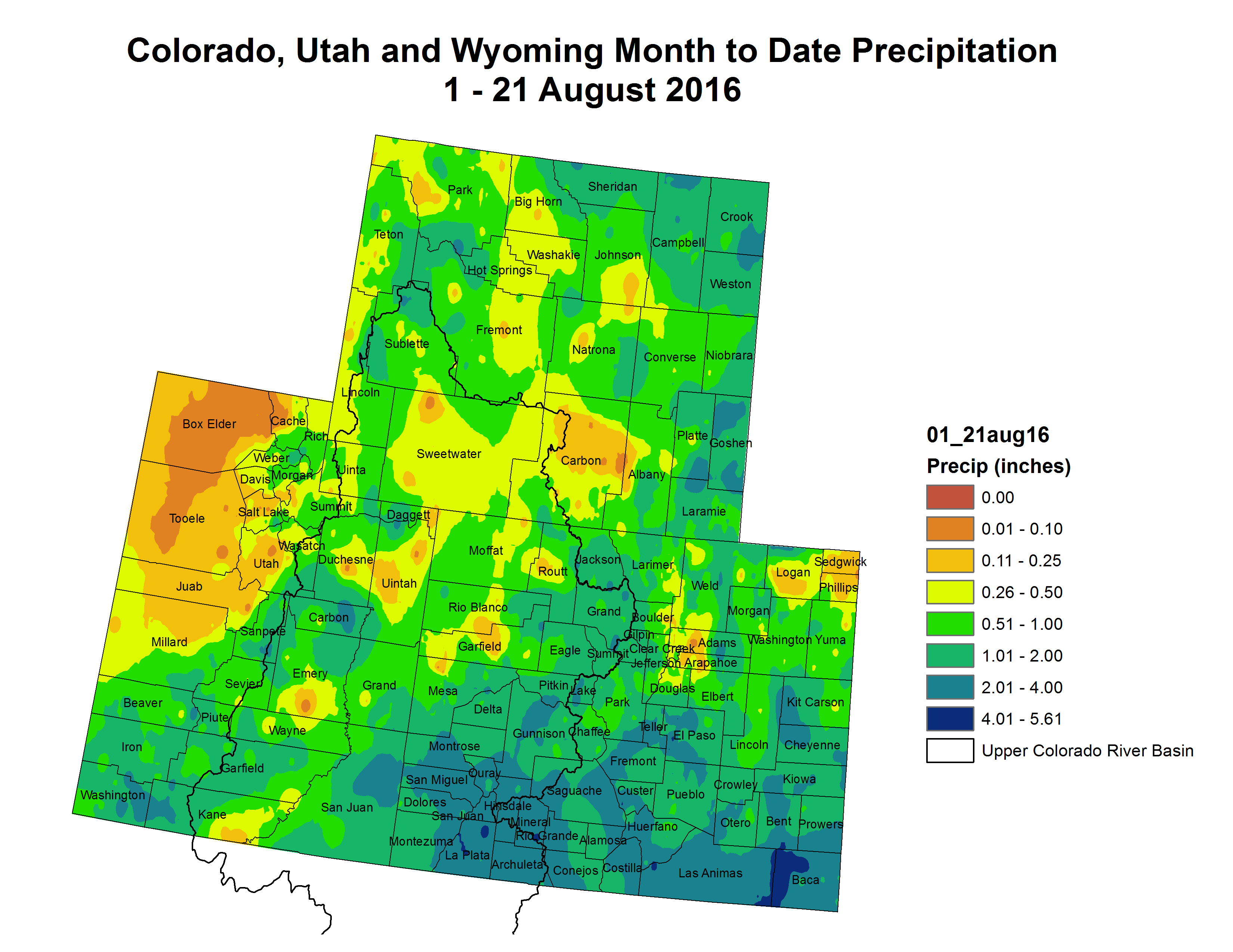
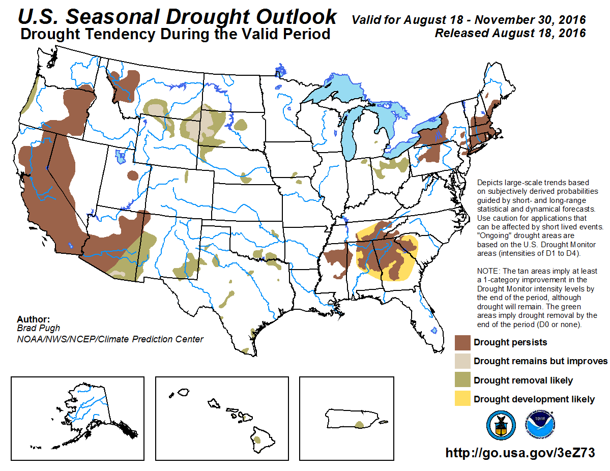
Click here to go to the US Drought Monitor website. Here’s an excerpt:
Summary
An active weather pattern across the central and eastern U.S. led to more drought reduction than introduction, although pesky dryness and hot conditions led to some expansion of dryness and drought in the southern Atlantic States. In stark contrast, catastrophic flooding from the historic, August 12-13 downpours gradually subsided across southern Louisiana; as recovery efforts began, media reports noted that there were at least a dozen fatalities and that more than 60,000 residences were damaged or destroyed. Heavy rain shifted northward and westward during the drought-monitoring period, soaking the western Gulf Coast region and delivering spotty drought relief across the interior Southeast. Pockets of locally heavy rain were also noted across the northern and central Plains, the Midwest, and the Northeast. Elsewhere, scant rainfall occurred west of the Rockies, except for a few monsoon-related showers in the Southwest…
Southern Plains
Multiple rounds of heavy rain drenched the western Gulf Coast region, but only spotty showers dotted the southern High Plains. As a result, there was a marked difference between dryness/drought eradication in much of southern and eastern Texas and drought intensification across western Texas and eastern New Mexico. Through August 23, month-to-date rainfall surged to 8.82 inches (600% of normal) in Del Rio, Texas. In contrast, June 1 – August 23 rainfall in Lubbock, Texas, totaled just 2.46 inches (39% of normal). Severe drought (D2) was introduced in an area straddling the Texas-New Mexico border. On August 21, topsoil moisture in New Mexico was rated 78% very short to short, according to USDA. Also on August 21, at least one-quarter of the cotton was rated very poor to poor in New Mexico (28%) and Texas (25%). Nationally, only 18% of the cotton crop was rated very poor to poor. Deteriorating conditions were also noted in parts of central and northeastern Oklahoma, as shown by expansion of dryness (D0) and moderate drought (D1)…
North Plains and Corn Belt
Well-placed showers brought some relief to drought-affected areas from southern Montana to the Black Hills of South Dakota. Pockets of dryness (D0) and moderate drought (D1) were also reduced in size or eliminated in parts of the western and eastern Corn Belt. On August 21, Ohio and Michigan led the Midwest with 29% of the pastures rated very poor to poor, according to USDA. Montana led the northern Plains with one-third (33%) of its rangeland and pastures rated very poor to poor, followed by South Dakota with 25%. Rain in the eastern Corn Belt brought improved crop conditions; from August 14 to 21, corn rated very poor to poor declined from 22 to 21% in Ohio and from 18 to 15% in Michigan. Similarly, soybeans rated very poor to poor declined from 15 to 13% in Ohio and from 15 to 11% in Michigan…
Northwest
Several cold fronts crossed the Northwest, accompanied by breezy conditions but little rainfall. By August 23, nearly three dozen large wildfires—in various stages of containment—were burning across the Northwest. Among them were the 100,000-acre Pioneer fire north of Idaho City, Idaho, and the 21,000-acre Copper King fire near Thompson Falls, Montana. In eastern Washington, a half-dozen large fires were burning, including the 6,000-acre Spokane complex. Due to short-term dryness, abnormal dryness (D0) and/or moderate drought (D1) were expanded in several areas, including southwestern Washington, northern Utah, and northwestern Colorado. On August 21, Oregon led the West with 49% of its rangeland and pastures rated in very poor to poor condition, according to USDA…
Southwest
Spotty monsoon-related showers were heaviest in the southern Rockies. However, the Southwestern drought depiction was largely unchanged, except for a small reduction in the coverage of dryness (D0) in north-central New Mexico. Drought expansion in parts of eastern New Mexico was discussed in the “Southern Plains” paragraph…
California
No changes to the drought depiction were made in California, as the summer dry season continued. Still, long-term drought and a variety of weather factors contributed to the spread of the destructive Blue Cut fire, which scorched more than 36,000 acres of vegetation near Lytle Creek, California, northwest of San Bernardino. The fire also destroyed at least 105 homes and more than 200 outbuildings…
Looking Ahead
For the remainder of the week, late-summer heat will return to the East and the Far West, while a surge of cool air will briefly cover much of the nation’s mid-section. During the weekend, however, temperatures will rebound to near- or above-normal levels in the central U.S., while late-season heat will persist in the East and West. During the next 5 days, the most significant, large-scale plume of moisture will stretch from southern sections of the Rockies and Plains into the Great Lakes region, resulting in 1- to 5-inch rainfall totals. In contrast, the Far West and the Mid-Atlantic States will remain mostly dry. During the weekend, a tropical wave (or named tropical storm) could result in heavy showers and local flooding in the southern Atlantic region, especially across southern Florida.
The NWS 6- to 10-day outlook for August 30 – September 3 calls for the likelihood of above-normal temperatures nearly nationwide, with the greatest odds of late-summer heat occurring in the eastern U.S. Cooler-than-normal conditions should be confined to northern California and the Pacific Northwest. Meanwhile, below-normal rainfall across the Intermountain West, Southwest, and central and southern Plains will contrast with wetter-than-normal weather across the nation’s northern tier, along and near the Gulf Coast, and in the mid-South and Midwest.
I’m at the conference getting ready for the first session: Leading the way with direct potable reuse in Colorado. Panel with moderator Doug Kemper (Colorado Water Congress), Myron Nealey (Denver Water), John Rehring (Carollo Engineers).
CWC has an iPhone app up at the app store. Search for CWC and scroll down to CWC Summer Conference.
Nice bike ride up the Yampa River from my campsite west of town. The Sheraton Steamboat Springs lets you check your bike and park it in a room out of the elements.
I’m heading over to Steamboat Springs for the Colorado Water Congress’ Summer Conference and Membership Meeting. Posting will be hit and miss through Friday. I’ll try to catch up on Saturday. Follow me on Twitter (@CoyoteGulch).
I have noticed a lot of chatter lately about the situation at Lake Mead. Dramatic overuse, prolonged drought, and the effects of increased temperatures have led to a historically low volume of water stored in the largest reservoir on the Colorado River. One of the most critical components of water in the west is less than 40% full. Yet while some people scramble for a quick fix or point fingers, others see the long game and note the optimism that working together for smart, sustainable solutions can bring. There is hope, there is a roadmap, and together we have the knowledge, skill, and foresight to make it happen.
Lake Mead behind Hoover Dam December 2015 via Greg Hobbs.
The Discovery Channel recently produced a new documentary, Killing the Colorado, a made-for-TV version of the lengthy ProPublica series of the same name. The show is excellent, comprehensive, and features a number of voices that you may not expect to be featured in a film about the environment. Imperial valley agricultural producers, water managers, a red-state Senator and a blue-state Governor – all identifying problems facing the basin, and most putting forth an optimistic view that a human-caused predicament can be solved with human-inspired ingenuity.
One quote in particular is poignant – there is a scene with Colorado Governor John Hickenlooper in his office flipping through a binder full of historic water compacts. Upon his observance of the generations of water agreements, he remarks “The thing you realize when you go through these [water] compacts, is that everyone is in this together.” Given the situation facing Lake Mead, a growing chorus of voices around Lake Powell, the birth of the Colorado Water Plan, and a recognition that heathy rivers support healthy agriculture and sustainable economies, we truly are all rowing the same boat together in the Colorado Basin.
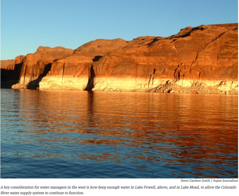
Lake Powell via Aspen Journalism
But, how can Lake Mead affect Colorado from a thousand miles downstream? Well, due to the Colorado River Compact of 1922, headwaters states like Colorado must send a certain amount of water to the Southwestern states of Arizona, Nevada, and California – it’s the law of the river, and the law of the land. And since when the Compact was developed, California was a fast growing destination, it has priority and can “call” for water if needed. For years, California has had the luxury to get much of the surplus of water that Colorado and Wyoming have sent downstream to be stored in Lake Powell and Lake Mead. But now with prolonged drought, a fast-growing population across the entire Southwest, and a substantial agricultural economy (especially in the Imperial Valley), the era of surplus water is over. As such, Lake Mead is directly connected to Colorado, whether we like it or not, and that connection is the Colorado River.
Killing the Colorado does a fantastic job over nearly an hour-and-a-half of highlighting a variety of colorful characters who have recognized that shortage and a lack of water will change everything in the future – that future is now. But while both the show and the written article are excellent at highlighting the situation, they don’t delve deeply into what I think is most important – that real solutions do exist, and we know how to implement them, it simply takes our collective will to get them moving. Solutions like urban and agricultural conservation and efficiency, like reuse and recycling, like innovative water banking and flexible management practices, like continuing the shift towards renewable energy (solar and wind don’t devour cooling water like natural gas and coal plants require). But while these efforts all seem daunting and out of an individual’s control, there are actions that each of us can take every day that together, make a huge difference. Like buying and installing your own rain barrel for your outside plants and flowers, like supporting your local farmer at the farmer’s market – small things that have a great impact, especially when we all do them together.
Solutions do exist, and as Arizona Senator Jeff Flake said “The drought over the past couple of years has awakened all of us to the future we have if we don’t do better planning. There are many things that are out of our control…Planning is so important. Conserving. Recharging. Water banking. Water markets. These are all important things that have to take place.”
Let’s get started!
The Yampa River flows through the Carpenter Ranch. Photo courtesy of John Fielder from his new book, “Colorado’s Yampa River: Free Flowing & Wild from the Flat Tops to the Green.” — via The Mountain Town News
Health and environmental officials in San Juan County are evaluating the Animas River after roughly 1 million gallons of mine waste water were released Wednesday. August 6, 2015. (Photo courtesy San Juan Basin Health Department)
The Gold King Mine Citizens’ Advisory Committee heard an update on the quality of the drinking water during its meeting today at San Juan College.
Stephanie Stringer, chief of the New Mexico Environment Department’s Drinking Water Bureau, gave a presentation to the committee on the status of public water systems in the Animas and San Juan watersheds.
The committee includes 11 volunteers who monitor efforts to document the long-term effects of the mine spill, which in August 2015 released more than 3 million gallons of towaste water with heavy metals into the Animas Rivers.
About 89,000 San Juan County residents’ water systems were affected by the mine when intakes were closed to protect treatment plants and water reservoirs, according to Stringer’s presentation. That figure does not include water systems on the Navajo Nation, which are not monitored by the state agency.
But in the year after the mine spill, the affected public water systems have remained in compliance with drinking water quality standards, Stringer said.
She said no metal contamination was found in any of the drinking water samples collected by the U.S. Environmental Protection Agency.
“With a couple of minor exceptions of failing infrastructure systems, the public water systems are doing their job, and the water is safe to drink,” Stringer said after the meeting.
While not related to the mine spill, poor infrastructure maintenance is behind the failing treatment systems of the Morningstar and Harvest Gold water systems, Stringer said. Operated by the AV Water Co., the two systems serve nearly 7,000 residents in Crouch Mesa and areas outside Bloomfield. Those customers have been under a boil advisory since May 25 because of the failing treatment plants.
Drinking water from all other public water systems is safe for all uses, according to Stringer.
In her presentation, Stringer also detailed the bureau’s efforts to monitor the quality of the drinking water systems after the mine spill. Stringer said some public water systems are developing plans in case an emergency again threatens drinking water.
“We are encouraging all the public water systems to develop source water protection plans to ensure they know what to do in an event such as this,” Stringer said after the meeting.
The Gold King Mine Citizens’ Advisory Committee will meet next at 5:30 p.m. Sept. 26 at the Nenahnezad Chapter house in Fruitland.
“We don’t know if that’s early or late 2017,” said Brian Werner, communications manager for the Berthoud-based Northern Colorado Water Conservancy District, the driving force behind the proposed Northern Integrated Supply Project. Noting that the planning process for NISP now is in its 13th year, he added that “given the pace so far, we’d expect to see it released to the public toward the latter part of the year.”
[…]
The additional opportunity for public input “is not something we’d ordinarily do,” said John Urbanic, a Littleton-based senior project manager for the Corps’ Omaha District. “There’s typically no comment period on the final because the studies have been completed.”
The change in Corps policy was decided, Urbanic said, because the Corps has done additional water-quality analyses since it issued a Supplemental Draft EIS in June 2015. The final EIS will include updated environmental studies, as well as refinements that project manager Northern Water has made to its proposal.
In April, Northern Water responded to last year’s sharp criticism from citizens and some governmental bodies by revising its plans in order to provide a larger, steadier flow of water in the Cache la Poudre River as it flows through Fort Collins. The change would include releasing 14,000 acre-feet of water a year from Glade Reservoir into the Poudre for a 12-mile stretch through the city, then capturing it again at the “Timnath Inlet” near East Mulberry Street west of Interstate 25 through a pumping station and pipeline that would carry it down the Larimer-Weld county line to Northern Water’s Southern Water Supply Project, which serves communities from Broomfield to Fort Morgan.
Northern Water designed the revision to help allay opponents’ fears that by draining water from the Poudre, NISP would limit opportunities for recreation that include tubing, whitewater kayaking and fishing. The Fort Collins City Council late last summer unanimously voted to conditionally oppose the project, based on a report from a broad range of city departments that listed concerns about water-quality degradation because of reduced streamflow that could cause the city to spend tens of millions of dollars on extra water treatment, as well as what they saw as an incomplete supplemental draft EIS by the Corps.
Northern Water’s revised plan also would eliminate a proposed pipeline from Horsetooth Reservoir, west of Fort Collins, into the NISP system, Werner said — another response to public concerns.
Then in July, Werner said the proposed Galeton Reservoir might have to be moved because the site is home to about two dozen active oil and gas wells operated by Noble Energy…
“The move of the Galeton Reservoir site will not slow down the process further,” Werner told BizWest on Monday.
Urbanic said all public input received during the comment period for the final EIS will be reviewed and addressed in the “Record of Decision,” which completes the Corps’ permitting process.
About a dozen cities and towns and four water districts have signed up to buy water from the project if it wins final approval from the Corps. Supporters see NISP as crucial to keeping up with the growing demands of development, industry and agriculture along the Front Range and catching rainwater and snowmelt for use in drier years.
Lease-fallowing plan so successful, no one notices
After all of the fireworks that accompanied creation of the Arkansas Valley Super Ditch, the actual operation has attracted little notice.
By design.
“We put enough water into the ponds so that no one on the river knows this is happening,” Jack Goble, engineer for the Lower Arkansas Valley Water Conservancy District, told the board Wednesday.
Goble gave an update on the Super Ditch pilot program that is providing water to Fountain, Security and Fowler from farm ground dried up on the Catlin Canal near Rocky Ford. The water is accounted for on a dayto- day basis, with deliveries to the cities each month. The response of all participants has been enthusiastic.
“With crop values down, they want to fallow more farms,” Goble said.
But under [HB13-1248], passed by the state Legislature in 2013, that can’t happen. The law limits 30 percent of the farmland enrolled in the program to be fallowed in any given year, and each farm can be dried up only three years in 10.
This year, only 26 percent of the 900 acres on six farms in the program were fallowed and so far have yielded more water than at the same time last year. Through the end of July, the program yielded 239 acre-feet (78 million gallons). That’s on track to beat last year’s yield of 409 acre-feet.
But that depends on what happens the rest of this irrigation season, Goble said.
Water not used on fields is channeled into recharge ponds, which mimic the runoff and seepage that would have occurred if the farms had been irrigated. The ponds also cover their own evaporative losses. Recharge stations measure the flows on the ditch each day.
Those numbers are plugged into formulas that compute the consumptive use — the amount of water crops traditionally grown in the fields would have consumed.
On a monthly basis, the consumptive use equivalent is transferred, on paper, from Lower Ark accounts to Security and Fountain accounts in Lake Pueblo, where it is transported through the Fountain Valley Conduit.
For Fowler, the water is moved to Colorado Water Protective and Development Association accounts to augment the town’s wells.
“We need to let the water community know, ‘Hey, this works,’ ’’ said Peter Nichols, attorney for the Lower Ark district and Super Ditch.
Participants have had to overcome skepticism, opposition and even lawsuits since 2012 to achieve results that have been favorable to everyone involved, he said.
Leah Martinsson and Megan Gutwein, of Nichols’ Boulder Law office, are writing articles about the success of the program for national water and legal journals. Nichols also suggested presenting a report on the progress of Super Ditch to Colorado Water Congress and the Colorado Water Conservation Board.
“We’ve done a pretty incredible job,” added Lynden Gill, president of the Lower Ark board. “The first year, it seemed like there were nothing but roadblocks. It’s absolutely incredible, the progress we’ve made.”
An acequia along the Las Trampas in northern New Mexico is suspended on a trestle. (Eddie Moore/Albuquerque Journal)
From the Taos Soil and Water Conservation District via TaosNews.com:
Earlier this year, the Taos Soil and Water Conservation District (SWCD) received a grant for more than $37,000 from the New Mexico Youth Conservation Corps (YCC) to put Taos youth to work mapping and documenting the condition of acequias within the town of Taos.
Ten Taos youth participated and earned an income, transferable University of New Mexico science credits and Taos High School science credits. Taos SWCD hired three trainers — David Gilroy, Miguel Santistevan and Enrique Gonzales — to teach the students about the cultural, financial, biological and historical importance of acequias.
The students also earned their American Red Cross first aid certification and were taught how to work as a team and how to use GPS units and ArcView geographic information systems.
As they walked the acequias, they were accompanied by mayordomos, who were each interviewed. Students had many guest speakers who taught them about the identification of weed infestations, legal issues that acequias face, water table/recharge issues and more.
Late last month, the Taos SWCD held its 75th annual meeting and potluck at the Juan I. Gonzales Agricultural Center, located at 202 Chamisa Road. The guest speakers were the YCC students, who presented the outcome of the project.
About 110 community members attended, including Taos Mayor Dan Barrone, Town Manager Rick Bellis, City Councilman Fritz Hahn, County Commissioner Candyce O’Donnell and more. The YCC students later presented at a town council meeting, and another presentation was scheduled before the county commission.
“I think it is so important for Taos youth to learn about the acequias that define Taos, to understand the gravity of ignoring restoration needs and to get involved in protecting what remains. This project may become an annual endeavor for Taos SWCD – we’ll be assessing the success when this year’s program is complete,” said project organizer Tanya Duncan.
In a way, the whole reason a state water plan is needed lies north of the Pueblo County line.
In the Arkansas River basin, three-fourths of the future need identified in a 2008 study was in El Paso County, the fastest growing area in the region. Like Denver, the metropolitan growth has the potential to dry up rural farming areas.
Not all of the growth is in Colorado Springs; it’s in outlying areas, as well.
For more than a decade, The Pueblo Chieftain has documented the progress of the Southern Delivery System, purchases of water rights by El Paso County cities or water providers, and water quality issues, such as changing limits on groundwater contaminants.
Cherokee Metro District President Jan Cederberg and Fountain Water Engineer Mike Fink give their viewpoints on Colorado’s Water Plan, based on questions supplied by The Chieftain on behalf of the Arkansas Basin Roundtable.
Cherokee, a district that sits like an island within Colorado Springs, over the last decade has looked at various pipelines from other areas to meet its water needs.
Fountain, a city south of Colorado Springs, gets its water from several sources but is relying heavily on SDS, which also allows it to draw more water through the Fountain Valley Conduit.
How do we fill the gap in the Arkansas River Basin within the Colorado Water Plan and Basin Implementation Plan?
Cederberg: Given that the river is already over-appropriated, we will all need to keep on a continuous path of improving water efficiency, but recognize that alone will not close the gap. We will also need to collaborate with our friends and neighbors in the basin to make best use of the water resources available through innovative arrangements such as alternative transfer methods. Ultimately, water uses are likely to be prioritized to “highest and best uses” in response to market economics.
Fink: Each water supplier and all of the major water users in the Arkansas Basin will need to participate in the effort to fill the gap. All elements of the water supply pantheon should be reviewed for improvements in yield, improvement of efficiencies in the sources, in the transportation, storage and treatment, delivery and return flow management and conservation (both the supply side and the demand side).
What projects do you plan to fill the gap?
Cederberg: Cherokee Metropolitan District’s primary supply is alluvial groundwater in the Upper Black Squirrel Creek designated basin. We will continue considering the purchase of water rights from that basin as they are made available.
We also recently developed a new Denver Basin well field near Black Forest, approximately 15 miles north of our main service area. Although this supply is regarded as unsustainable for the long term, it is drought-proof and can be used in conjunction with junior water rights to help meet dry-year demands. We will grow this well field and consider strategies to extend the life of this Denver Basin supply.
In addition, the Cherokee Metropolitan District is collaborating with several other members of the Pikes Peak Regional Water Authority to consider a regional water system that would allow efficient delivery of water from the Fountain Creek/Arkansas River system.
Fink: Fountain Utilities adopted a comprehensive Water Master Plan in 2007. It was a decisional study that confirmed our participation in the Southern Delivery System Project, but it also provided a longer planning horizon for development of supply diversity and redundancy, treatment options, transmission system planning and delivery system planning.
One foundational element of the 2007 Water Master Plan was a dedication to enhancing the City’s Water Conservation efforts.
The projects that Fountain Utilities will either continue or commence implementation to improve our ability to meet the demands that increased population require include the following:
1. Southern Delivery System — SDS is an important addition to our utility’s supply system, but it is only a tool to move water from the Pueblo Reservoir and treat that water; SDS does not provide water, it only moves and treats water. Each of the participants is required to bring their own water to the pipe.
2. Return flow management — Fountain, as a beneficiary of the Fryingpan-Arkansas Project, receives an allocation of transbasin water delivered through the Fountain Valley Authority transmission and treatment system. This allocation is usable to extinction and the City will continue to maximize the use of this water through effective return-flow management.
3. Continued use of local groundwater resources — Fountain has groundwater wells that are both in the Fountain Aquifer and in the Widefield Aquifer. These are renewable resources that must have depletions augmented by surface water. Fountain’s continuing challenge is to treat the water from these sources to the quality that not only meets the Clean Drinking Water Standards, but that also maintains compliance with Health Advisories for trace contaminants.
Fountain, with Widefield and Security, is also pursuing the Widefield Aquifer Recharge Project. This long-term, renewable resource will divert flows from Fountain Creek into a treatment facility, inject the treated water into the Widefield Aquifer for storage that does not have evaporative losses, retrieve that water and treat it to drinking water standards.
How do we keep the gaps for agriculture and municipalities from becoming bigger?
Cederberg: We must continue to improve water efficiency on all fronts. As Cherokee has faced water supply challenges in recent years, we have asked our customers to conserve through watering restrictions and a tiered rate structure.
Their response, as proven through water demand data over time, has allowed us to reduce our demand forecast per home by more than 25 percent. In addition, Cherokee has developed an indirect reuse system by which reclaimed water recharges our main water supply aquifer.
Fink: All of the tools that the Colorado Water Plan examined (conservation, agriculture, storage, watershed health, education and outreach) will be needed to address demand, but I think that the coordination between water resource planning and land-use planning has possibly the most positive potential for closing the gap.
The one wild card in the identified tools in the Water Plan is innovation, and I am a firm believer that Colorado has the innovators to bring different and effective tools to the jobs than anyone has yet.
…on the Arkansas River, Pteronarcys californica has been missing from the menu for upwards of a century, the casualty of a toxic past.
One state aquatic biologist hypothesizes they suffered a localized extinction, or extirpation, during an era when Leadville mine waste flowed unchecked into the Arkansas. That was before new water treatment measures initiated a turnaround that began in the early 1990s and eventually spawned one of the state’s most popular fisheries.
Now an effort to re-establish the bug, also known as the giant stonefly, seeks to add a fresh chapter to the unfolding success story. It has anglers sitting up and taking notice, even as it puts the river’s vaunted recovery to the test.
In 2012, Colorado Parks and Wildlife launched a three-year effort that scooped up an estimated 135,000 giant salmonfly nymphs from the Colorado River near Kremmling and deposited them at eight test sites near Salida.
After mounting what the agency calls the largest insect transplantation on record, a problem emerged at a critical juncture.
In 2015, a year after the last of the salmonfly deliveries to the Arkansas, state wildlife workers went back to the test areas to gauge their progress, searching the riverbank in 100-foot swaths, from the water’s edge to the willows.
After 58 man hours, they found no evidence that transplanted salmonflies had crawled out of the river to shed their exoskeletons and sprout wings, the culminating change in their roughly three-year lifecycle.
Further searches this spring and summer turned up no adults and little more than a “handful” of exoskeletal chucks, said Greg Policky, the state aquatic biologist who devised the experiment…
After mining came to Leadville in 1859, heavy metals began filtering into the Arkansas and ravaged its ecosystem, killing all fish around Leadville. Further downstream, near Salida, trout for decades lived for no more than two to three years – long enough to spawn, but too brief to acquire significant size.
“The Arkansas was a dead river,” said Jean Van Pelt of the Southeastern Colorado Water Conservancy District.
The river’s fate began to change in 1992, when two treatment facilities were constructed near Leadville to remove heavy metals like cadmium and zinc, generated on mine runoff, before they reached the river.
The effect was nearly immediate.
“It turned things around,” Policky said. “By 1994, we had a self-sustaining population of brown trout here.”
Better water quality cleared the way for two decades of piecemeal improvements, including efforts to restore the Arkansas to a natural state in areas where it had been straightened or otherwise modified, a common occurrence in the developing West.
One recent project in Hayden Flats south of Leadville, for example, created a new bend in the river by installing a subterranean structure of latticed logs and timber at the river bank, then burying it under transplanted willows. The result is a veritable “fish condo” that creates optimal flow conditions while giving trout a place to hide from predators.
Downstream near Salida, the effect of the river’s rehabilitation was profound, fattening up trout and extending their life expectancy to up to a decade.
In theory, it should have created trophy conditions for the giant salmonfly, too…
During all three years the bugs were stocked, they hatched in mid-May, fueling hopes it would be a matter of time before they took off like “gangbusters,” he said.
Back-to-back years without hatches suggest the process will be slower than expected; it could also indicate the experiment has been a failure.
Policky urges patience.
Any number of factors could explain the bugs’ apparent absence, Policky said, including competition from other bugs, or the large amount of sediment that washes into the river from the overgrown forests cloaking the Collegiate Peaks.
But he acknowledges the problem could also be environmental. For that reason, the search to explain the bugs’ failure to take wing is centered on water quality data measured by sensors by the river’s headwaters near Leadville.
So far, the data show no evidence of heavy metals in the water, but the monitoring isn’t continuous, raising the possibility that some level of contamination could be finding its way back in.
Standing at the river bank, he mulled the possibilities.
“Did heavy metals rear their ugly head again? Did we have a release that we don’t know about? This is the canary in the coal mine.
“If indeed I can track it to water quality, Pteronarcys is how I’m going to get there.”
On the other hand, fish and other bug communities appear to be thriving, an indication that perhaps some other cause is to blame. Policky chalks it up to another unknown in an unprecedented effort to revive a bug species through transplantation.
“Frankly, there’s never been anything like this, for sure not to this magnitude.”
Bicycling the Colorado National Monument, Grand Valley in the distance via Colorado.com
FromThe Grand Junction Daily Sentinel (Gary Harmon):
It’s when storms break uphill that the Buthorn Drain becomes overwhelmed and the network of pipes turns from a pastoral conveyance to a pressurized system for which it was never designed.
“I’ve seen that manhole cover blow two feet off the ground,” said Bruce Palmer, who has lived for 51 years near the manhole cover on Walnut Court, through which the running water can be heard. “I’ve stood here in 9-inch engineer-type boots and the water was running over the top of those boots.”
The Buthorn Drain runs beneath the property of 50 or 60 residences, through a mobile-home park, beneath businesses and streets, and below — and through — a park.
It runs below Westlake Park downhill from West Middle School and then flows above and below a hill steep enough that concrete piles, or baffles, have been built in its path to slow floodwaters. Those same waters have dug beneath the baffles, reducing their ability to slow the floods.
The Grand Valley Drainage District made the Buthorn Drain its top priority and is expecting to spend $5 million on repairs and improvements to it, beginning with a close look at the system by Eric Krch of the engineering firm Souder Miller & Associates.
The first step in his study is to make sure that the drain still can handle its main job, then move into the question of whether it could handle a [1% probability flood].
It almost surely will not. Work already done has shown the system to be “severely undersized” for the 922-acre watershed served by the Buthorn Drain.
From there, Krch will draw up one or more solutions he’ll propose to the drainage district…
Businesses, local governments and other property owners, including churches and nonprofits, are charged $3 a month for every 2,500 square feet of impervious surface — those roofs, driveways, parking lots and so on. The district also has a $500 per 2,500 feet of impervious surface fee on new construction.
In all, the charges are expected to generate $2.7 million this year.
The fees, however, have earned the ire of Mesa County and the Grand Junction Area Chamber of Commerce, which have challenged them in Mesa County District Court, contending that they amount to a tax that was imposed without a vote as required by the Colorado Constitution.
A judge, however, has ruled in denying a preliminary injunction that the charges are fees and not subject to the voter-approval requirement of the Taxpayer’s Bill of Rights.
A full hearing on the matter remains to be scheduled — attorneys next week are to set a schedule — even as the district is moving ahead with the Buthorn Drain by hiring Souder Miller & Associates.
County and chamber officials say they don’t question the need for improvements such as those contemplated for the Buthorn Drain, but say they prefer to tackle drainage issues — and there are plenty — on a larger scale, using the 5-2-1 Drainage Authority.
The authority encompasses an area 10 times larger than that of the district. It takes in lands north of the river that are outside the boundaries of the drainage district, as well as land south of the river.
The county also questions the leadership of the drainage district, characterizing the three-member board as self-perpetuating.
The election of Cody Davis to the drainage district board this year was the first contest in decades.
All of those issues are beside the point for Ryan, who contends that the drainage district board is dealing properly with issues inside district boundaries, which happen to include much of the most heavily populated parts of the county, as well as much of its commercial and industrial base.
Dealing with the Buthorn Drain means dealing with “a major public health hazard,” Krch said.
When the drain is overfilled by stormwater, Krch said, “People have suffered significant damages to their possessions, there has been loss of property and I don’t know how many accidents occurred on flooded streets.”
Steamy temperatures, a lack of shady trees and stagnant, shallow waters make the pond [Duckwood Pond in Fountain Creek Regional Park ] a breeding ground for the green algae, which thrives on warmth and sunlight. Another ingredient for the algae’s success, nitrogen, is added by the resident flock of Canada geese, with each bird producing about a pound of nutrient-rich feces each day…
The photosynthetic, plant-like organisms are found in practically every…body of water, from ponds to reservoirs, and can multiply rapidly under the right conditions to create algae blooms. Luckily, there are no negative effects on the body of water’s aquatic ecosystem – only its aesthetic value, Salamon said.
But it’s often hard to distinguish regular algae with its much less innocuous counterpart: cyanobacteria, also known as blue-green algae. For reasons scientists haven’t nailed down, cyanobacteria blooms can sometimes produce toxins that threaten nearby flora and fauna.
Of the 150 lakes across the state sampled routinely by the Colorado Department of Public Health and Environment, about 30 have tested positive for blue-green algae, including 10 to 15 that regularly produce blue-green algae blooms, according to the department.
And while officials have not observed any negative consequences for wildlife connected to the presence of cyanobacteria, state agencies are taking precautions.
The department has developed an in-house testing method to determine if the blue-green algae is producing harmful toxins, what the toxins are and how concentrated they are, said Sarah Wheeler, a researcher at the state’s Water Quality Control Division…
According to Colorado Parks and Wildlife, areas where cyanobacteria blooms have occurred include Stagecoach State Park, Barr Lake State Park, and Cherry Creek State Park and De Weese Reservoir.
The cyanobacteria blooms most often occur in urban areas and agricultural regions the eastern plains that experience a lot of runoff from fertilizers – the same places that are hotspots for regular algae blooms, Wheeler said.
“Cyanobacteria do really well with high nutrients and lots of sunlight – they form when conditions are right, so when the temperatures are really hot in the summer, the water temperatures increase and you also have high nitrogen,” she said.
Unlike most other contaminants, cyanobacteria and the toxins they produce are not regulated by the Environmental Protection Agency, so it’s up to state officials to decide how to monitor its presence in recreational and drinking water sources. In June 2015, the EPA issued a drinking-water health advisory for two contaminants sometimes produced by cyanobacteria: microcystins and cylindrospermopsin.
Research has associated high levels of drinking water containing the toxins with stomach flu, liver and kidney damage. People swimming in lakes where cyanobacteria was present have reported stomachaches, allergic reactions and skin rashes. For wildlife, long-term exposure may also lead to liver and kidney damage, according to the EPA advisory.
While officials have observed some drinking-water sources that have cyanobacteria blooms, none has tested positively for levels of above-recommended levels of microcystins and cylindrospermopsin specified in the EPA’s health advisory, said David Dani, who oversees coaching and training for the Colorado Safe Drinking Water Program…
In 2014, the agency formed the Algal Toxin Team, consisting of park, district, area and deputy regional managers, as well as public information officers. Last spring, Parks and Wildlife met with environmental epidemiology officials from the health and environment department to determine at what toxin level warning or caution signs should be posted at bodies of water containing cyanobacteria blooms.
The guidelines also help park officials identify the blooms, [Mindi May] said.
One method is the stick test: If you run a stick through the water and strings of the algae cling to the stick, it’s filamentous algae, not cyanobacteria. Another is the bottle test: If you scoop up some of the water and the algae sinks to the bottom of the container, it’s probably regular algae and not cyanobacteria, which would float or remain suspended in the water.
When park officials identify a cyanobacteria bloom, there is often little they can do besides wait for the bloom to subside, which can happen within days, May said.
Click here to read the newsletter. Here’s the Director’s Letter from Reagan Waskom:
Big promises are being made for big data. The tsunami of data resulting from new technologies has created some headaches, but also intriguing opportunities. Satellite images, wireless sensor networks, and model output
all produce data that must be processed and analyzed to create useful and reliable information. Data does not enhance our understanding or management decisions. Rather, it must be transformed into information that is accurate and reliable to become truly useful.
Data acquisition capacity has grown to the extent that a new branch of information sciences has emerged, known as big data. Big data has been called a “fad” in scienti c research, but it is more accurate to call it a “hot topic”, as we know the cascade of data from expanding new technologies will only continue. Numerous scienti c conferences and papers on the topic of big data have occurred since the Obama Administration launched the Big Data Research and Development Initiative in 2012 to “greatly improve tools and techniques needed to access, organize, and glean discoveries from huge volumes of digital data.”
Big data has been described as high volume, high velocity, and/or high variety information in excess of one terabyte that is too large for a single machine to handle and that traditional techniques are insuf cient to analyze. This de nition is fluid and may soon be described in petabytes, but it also includes the velocity at which the data is acquired from multiple independent data sources. Thus, cloud-linked servers are typically needed to adequately store and process the data. Real-time acquisition and processing that enables trend detection and improved decision-making is the goal of businesses and government agencies seeking to exploit big data. In other cases, the goal may be to enable public access to useful, interesting, or important information.
A number of questions must be resolved as we develop new data technologies and capacity. For example, who owns big data when it is crowd-sourced or provided by multiple public and private entities? How does the information remain secure and individual privacy protected? From a scienti c perspective, what about data quality and veracity? How do we avoid sampling bias and misinterpretation? Again, data itself is not the goal, but the information gleaned from the data can enhance our understanding of trends, processes, demographics, etc.
Water data collected from multiple public water systems (such as used in past Statewide Water Supply Investigations conducted by the CWCB) is an example of using big data to determine statistical patterns that suggest significant correlations and trends in water use and conservation, forecasting future demands, and to optimize coordination of resources. Water managers with multiple sources of water supply could also bene t from better data- driven forecasting and real-time operations. Sensor technologies have arrived on the market to help water utilities survey underground pipes and detect leaks. Smart meters could help managers and individual users ne-tune their system. In terms of academic research, both the NSF funded NEON and CUASHI networks described in this newsletter have been organized to provide big and open data to researchers. NEON represents the largest single investment in ecological research data ever made. This “research infrastructure” is transforming our ability to advance data visualization and statistical methods to understand patterns, processes, and detect outliers.
The value of big data is the opportunity to answer big questions. What is also exciting about big and open data is the potential for innovations that can improve our decision- making capacity. This issue of the Colorado Water newsletter provides examples of how big data for water can be accessed and used. The data tsunami keeps coming at us—the power of that data to help solve big water challenges is ours to capture.
The Omaha District, U.S. Army Corps of Engineers will accept public comments on the Northern Integrated Supply Project (NISP) Final Environmental Impact Statement (EIS), which is due to be released in 2017.
A formal comment period for the Final EIS provides the public an opportunity to review and provide comment about additional water quality analyses that have been taking place since the Supplemental Draft EIS was released in June 2015. The Final EIS will include updated environmental studies as well as refinements to Northern Colorado Water Conservancy District’s proposed action.
All public input received during the comment period for the Final EIS will be reviewed and addressed in the Record of Decision, which completes the U.S. Army Corps of Engineers permitting process.
… the last time the lake was at full capacity, with water levels 1,225 feet above sea level, was in 1983. Since then, and particularly since the year 2000, its surface levels have been steadily dropping, leaving behind a striking white “bathtub ring” around the shoreline showing how the water levels have decreased over the years. Currently, demand on Lake Mead has been removing more water than is being replenished, resulting in a deficit of about 1.2 million acre-feet, or about 400 billion gallons, each year.
According to federal guidelines, a shortage is to be declared at the start of any given year if Lake Mead’s water levels have sunk below 1,075 feet above sea level. The new federal projections, spanning the next 24 months, suggest that the elevation will be hovering just below 1,079 feet at the end of this December.
By the end of December 2017, however, the report predicts that water levels will have sunk to about 1,074 feet. If this occurs, the federal government will declare a shortage and affected states will be obligated to reduce their water consumption.
Avoiding a shortage in 2017 can be viewed as a temporary victory, said Jennifer Pitt, the National Audubon Society’s Colorado River project director.
“Were it not for some extraordinary efforts by lower basin water users in California, in Arizona, in Nevada and in Mexico to reduce their use of water already, we would in fact have seen a shortage in the lower basin,” she said.
In 2012, the U.S. and Mexico entered into an agreement known as Minute 319, a cooperative water management plan under which Mexico has been storing water in Lake Mead to help bolster the reservoir’s falling water levels. Under the agreement, Mexico agreed to take part in both surpluses and shortages as they’re declared for the reservoir. The agreement is set to expire next year, but officials have already opened negotiations to potentially extend it.
And in 2014, the Bureau of Reclamation launched the Pilot System Conservation Program in cooperation with states in the lower Colorado River basin, which has involved a number of projects in California, Nevada and Arizona aimed at conserving water through storage initiatives and demand reduction. The agency estimates that the projects approved so far will have conserved more than 50,000 acre-feet of water — approximately 16 billion gallons — by the end of this year.
However, the projections for 2018 serve as a stark reminder that there’s still work to be done.
“I think it is a short-term success that we’ve avoided shortage this year, but it is a very clear reminder how close we are to the edge,” said Taylor Hawes, The Nature Conservancy’s Colorado River program director. “We are all in this together. It’s not just a lower basin problem, it’s a full basin problem, including Mexico and the upper basin. And we need to be developing solutions that work for all sectors and work toward long-term sustainability.”
Such solutions will likely be all the more important in the face of future climate change, according to Brad Udall, senior water and climate research scientist at Colorado State University’s Colorado Water Institute.
For the past 15 years, a combination of precipitation declines and unusually high temperatures have helped fuel the region’s ongoing drought.
“Because you have these warmer temperatures, you then get a whole bunch of other processes at play,” Udall said. “You get a higher evaporative load from soil, you get plants that green up sooner and use more water, you get more evaporation out of reservoirs, you get a longer growing season on both the spring and the fall ends. All of that leads to declines in runoff.”
Melting snowpack in the Rocky Mountains is the primary source of water replenishing Lake Mead and the other reservoirs each spring. But recent declines in precipitation mean there’s less snowpack available to melt in the first place. And thanks to the high temperatures in the region, what snow there is has been melting earlier, which adds to the problem. Typically, it’s best when the snow melts all at once as late in the season as possible, Udall said. When it melts sooner, it can trigger an early growing season for plants, which then suck up more water throughout the course of the spring than usual. This effect takes away from the water that runs off into the reservoir and can also contribute to longer fire seasons and increased evaporation of water from the soil, all of which also feed drought. And, more simply, an earlier melt can also result in lower water flow later in the summer, when water is needed the most.
These changes are “clearly climate change at work,” he said, adding, “Climate change is water change. This is the primary way by which we tiny little humans are going to get to feel the impacts of climate change. The water cycles will change.”
It’s still unclear how the region’s hydrology will continue to evolve as it continues to heat up. Climate models have presented a mixed bag of future scenarios, Udall noted. But so far, the warmer temperatures seem to be linked to long-term declines in flow. And Udall added that recent research has also suggested that future warming may increase the potential for “megadroughts” — droughts that last for decades, rather than just a few years.
“These warmer temperatures make it a lot easier to push the system into a dryness state that’s hard to escape from,” he said.
This year and last year, unusual weather events in the spring helped the river system avoid an otherwise impending shortage, Udall pointed out.
“In 2015, on April 1, the runoff forecast was for 74 percent of normal,” he said. “It was a pretty grim forecast.”
However, the country as a whole went on to experience an unusually wet May, which Udall said “bailed the system out from what would have been an earlier shortage declaration for sure.” This year, he said, a similar situation occurred.
But it’s not a phenomenon the western states should count on in the future, he added. There’s still a very real possibility that a shortage will occur in 2018, and a continuation of the water conservation initiatives undertaken so far — along with additional efforts — will be crucial to avoid a crisis.
Some experts have suggested implementing a policy in which lower basin states — Arizona in particular — would accept steeper cuts to their annual Colorado River water allocation while the reservoir still remains at higher elevations. A 2009 paper, which Udall co-authored, suggested that such aggressive tactics could significantly reduce the probability of crisis through at least mid-century.
This “drought contingency plan” is still a matter of discussion among the lower basin states and the Bureau of Reclamation, but some experts feel that its adoption is crucial to avoiding future crises.
“It is imperative that the three lower basin states adopt the lower basin drought contingency plan to stabilize the Colorado River supply and to give water users certainty about what their supplies will be in the future,” said Pitt of the National Audubon Society.
Ultimately whatever solutions are adopted in the future, experts agree that they must be a collaborative effort among all the beneficiaries of the Colorado River system.
“The sort of geopolitical reality of the Colorado River is that we’re all in it together,” Pitt said. “And all water users and all jurisdictions are going to have to work together to ensure that our water supply is stabilized and our uses don’t exceed what this river has to give.”
It’s August already, El Niño is long gone, and we’re still stuck in neutral. Is La Niña on the way? And is anything interesting going on in the tropical Pacific?
Currently, forecasters think there’s a slightly better than 50% chance of La Niña developing in August–October and then a 55-60% chance during the winter. Right now, it looks like if La Niña does manage to form and last the five consecutive, overlapping seasons necessary to qualify as an ENSO event, it’s likely to be a weak one.
Let’s start by checking in with current conditions. During July, sea surface temperature in the Nino3.4 region of the tropical Pacific was -0.21°C (-0.38°F) below average, according to ERSSTv4, the dataset we use for all our forecast verification. You may have also seen the monthly value for July from the OISST dataset, which was -0.49°C below average. Which one’s right?
Check out Tom’s post for details, but in short, these two datasets have different geographic detail: ERSSTv4 is lower resolution, while OISST has a finer grid with more spatial detail. Since the current area of colder-than-average water is a narrow strip along the Equator, the average over the Niño3.4 region can be different depending on the dataset.
Sea surface temperature in July 2016 compared to the 1981-2010 average. Cooler-than-average waters are present in the central tropical Pacific. NOAA Climate.gov map, based on GEO-Polar data.
I realize I haven’t answered the question “which one is right?” That’s because they both are–they’re just different. We use the ERSSTv4 for all our long-term monitoring, because it has been carefully quality-controlled and extends back to 1950. OISST is used as the starting point for a lot of climate models, because it has daily data available, and has that higher resolution. The finer detail in the OISST also allows it to pick up on smaller-scale changes like the current cool Niño3.4 index.
Situation Neutral
July’s tropical atmosphere mostly looked like neutral conditions, too, with nearly average winds across the tropical Pacific region. There have been some hints of more rain than average over Indonesia, and less over the central Pacific, as well as a slightly positive trend in the Southern Oscillation Index and Equatorial Southern Oscillation Index. These might be early hints of a La Niña pattern… or might just be short-term changes. So we’re playing a waiting game right now.
Like we did with El Niño, we have to see a certain set of conditions before we can declare the onset of La Niña. First, the monthly Niño3.4 index needs to drop to or below -0.5°C. It’s close, but not there yet. After that, we need to see forecasts that it will stay below that threshold for five overlapping three-month periods (“seasons”). Finally, we need to see the right response from the atmosphere: a strengthened Walker circulation, meaning stronger surface easterly and upper-level westerly winds over the equatorial Pacific Ocean, lower-than-average pressure and more rainfall over Indonesia, less rainfall over the central Pacific, and higher-than-average pressure in the vicinity of the eastern Pacific.
Flowchart showing decision process for determining La Niña conditions. Figure by Fiona Martin, adapted by Climate.gov.
What did one ocean say to the other? Nothing, it just waved.
If you look at the map of one-week average sea surface temperature, you may have noticed an interesting feature along the eastern and central equatorial Pacific: a series of waves along the edge of the “cold tongue”. The cold tongue (that term always gives me the heebie-jeebies) is a narrow strip of cooler water right along the Equator that’s present during neutral and La Niña conditions, and is strongest between July and November. It comes from deep ocean water that rises up near the South American coast, and is then spread westward by surface currents. El Niño’s warming reduces the cold tongue.
Sea surface temperature on July 23, 2016. The eastern Pacific cold tongue is clearly visible along the Equator, surrounded by warmer waters to the north and south. The wavy features along the northern and southern borders between the cold tongue and the warmer waters are tropical instability waves. The waves on the north side are clearer in part due to the stronger temperature gradient on that side of the cold tongue. Map by NOAA Climate.gov from CDR data.
The waves near the cold tongue are called tropical instability waves, and they were first noticed in 1977, at the beginning of the satellite era (1). They’re occasionally called Legeckis waves, after the scientist who first observed them. They emerge and move west over a few weeks, so they tend to get washed out in a monthly or seasonal average temperature anomaly map.
Tropical instability waves are partly a result of the difference in temperature between the cold tongue and the waters just north and south of the Equator. The interface between the colder and warmer water is called a front, just like the cold and warm fronts we see in the atmosphere. Whenever you have sharp differences in temperature, nature wants to mix it up to even things out, creating the conditions for waves to form. During La Niña, the cold tongue is cooler than average, and the fronts are intensified, usually leading to stronger tropical instability waves.
Tropical instability waves aren’t just an end result, though: they mix warmer water in to the cold tongue and interact with the atmosphere, affecting winds and surface pressure. ENSO influences the development of the waves (by affecting the north-south temperature gradient between the cold tongue and the off-equatorial water), and the waves and their atmospheric interaction can influence the characteristics of ENSO. Some researchers have found that, since tropical instability waves are prominent during La Niña, the effect of mixing the warmer waters in to the cold tongue can reduce the amplitude of La Niña (2).
A lot of research has been done to understand these waves and their interaction with ENSO, and there is some evidence that including them in the observations used as starting points for climate models can result in improved forecasts (3, 4). However, they’re just one feature of an immensely complicated system. For now, we’re back in borderline territory, and still in a La Niña Watch. We’ll continue keeping a close eye on both the tropical Pacific and computer model forecasts, and keep you posted on changes.
Many thanks to my colleagues Caihong Wen (Climate Prediction Center) and Jim Carton (University of Maryland, College Park) for their assistance with this post.
References
(1) Willett, C.S., R.R. Leben, and M.F. Lavin, 2006: Eddies and Tropical Instability Waves in the eastern tropical Pacific: A review, Progr. Oceanogr., 69, 218-238.
(2) Im, S.-H., S.-I. An, S. T. Kim, and F.-F. Jin (2015), Feedback processes responsible for El Niño-La Niña amplitude asymmetry, Geophys. Res. Lett., 42, 5556–5563, doi:10.1002/2015GL064853.
(3) Caihong Wen, Yan Xue, and Arun Kumar, 2012: Ocean–Atmosphere Characteristics of Tropical Instability Waves Simulated in the NCEP Climate Forecast System Reanalysis. J. Climate 25, 6409–6425, doi: 10.1175/JCLI-D-11-00477.1.
(4) Ham, Y. & Kang, I., 2011: Improvement of seasonal forecasts with inclusion of tropical instability waves on initial conditions. Clim Dyn 36: 1277. doi:10.1007/s00382-010-0743-0
Click here to read the update from the Colorado Water Conservation Board (Taryn Finnessey/Tracy Kosloff):
July 2016, was the second month in a row during which the state experienced well below average precipitation. Statewide mountain precipitation was only 59 percent of average, the driest July since 2008. Temperatures were also above average. August to-date has brought near average precipitation and slightly cooler temperatures statewide. However, the Front Range corridor remains dry and warm. The forecast for the next week shows cooler temperatures and better chances for precipitation.
Statewide water year-to-date mountain precipitation as reported from NRCS is at 97 percent of normal as of August 16th.
Reservoir storage statewide is 109 percent of normal. The Arkansas and the South Platte basins have the highest storage levels in the state at 115 percent of average; the Upper Rio Grande has the lowest storage levels at 89 percent. All other basins are above normal at 106 to 109 percent of average.
Front Range water providers all reported storage levels ranging from 83 to 124 percent of average, however continued warm and dry conditions have resulted in increased demands 10-20 percent greater than last year.
The Statewide Water Supply Index (SWSI) indicates that conditions are drier this month than last; however the majority of the state remains near average.
Agricultural producers are seeing high yields for both wheat and corn, and orchards are reporting good conditions as well.
Click here to go to the US Drought Monitor website. Here’s an excerpt:
Summary
A series of slow-moving or stationary cold fronts plus a westward wandering upper-air low along the Gulf Coast produced widespread moderate to heavy (more than 2 inches) rains in portions of the north-central Plains and upper Midwest, much of the Corn Belt, southern Great Plains, Ohio and lower Mississippi Valley, along the Gulf Coast, and the Northeast. Record flooding occurred in Louisiana where up to 2 feet of rain inundated the southern half of the state, requiring thousands of water rescues and drowning several people. Weekly amounts exceeding 8 inches also fell on southeastern Missouri, southern Illinois, north-central Indiana, and southwestern Lower Michigan. The southwest monsoon was also active, especially in New Mexico and southeastern Arizona where 1-2 inches of rain fell on several locations. Oppressive heat and humidity enveloped the northeastern quarter of the Nation, with weekly temperatures averaging more than 6 deg F above normal. Highs in the nineties were common, with some locations nearing triple-digits, but when combined with dew points in the seventies, apparent temperatures were unbearable to dangerous. In contrast, near to subnormal readings occurred across most of the western half of the U.S. and along the Gulf Coast. Most of Puerto Rico, Alaska, and Hawaii measured light to moderate rainfall, but not enough fell on the drought areas for any improvement…
Southern Plains
Abundant moisture from the southwest monsoon and the upper-air low interacted with a stationary cold front over the southern Plains, triggering numerous scattered showers and thunderstorms across southern and eastern sections of Texas and extreme southeastern Oklahoma. The rains, however, mostly missed the Texas Panhandle and the remainder of Oklahoma. With the scattered nature of the storms, totals varied widely, resulting in a spotted look to the remaining drought areas, although most changes were 1-category improvements (using 2-3 month tools). In contrast, subnormal rainfall resulted in some small degradation in the Texas Panhandle, extreme southern Texas, and in southern and northeastern Oklahoma. Field reports out of central and eastern Wagoner County (northeast OK) indicated worsening agricultural impacts due to less rainfall than surrounding counties, resulting in a D1 expansion and new D2 area…
North-Central Plains and western Corn Belt
A slow-moving cold front triggered widespread showers and thunderstorms across the north-central Plains, upper Midwest, and western Corn Belt. More than 2 inches of rain fell on most of the eastern Dakotas, central Minnesota, west-central Wisconsin, and southwestern and central Iowa, with locally up to 8 inches in parts of south-central Minnesota. This was the fourth out of the past 6 weeks with wet weather in Iowa. Accordingly, several 1-category improvements were made as the recent rains have eased or eliminated short-term dryness and drought. This included a good portion of South Dakota (D3 to D2 and D2 to D1 in the west; D1 to D0 in central sections; and D0 to nothing in northeastern and southeastern sections), northwestern Nebraska (D1 to D0 and D0 to nothing), Iowa (shrank D1 in the south, removed lots of D0), and northern Missouri (shrank D1 and D0). Most crop and pasture/range conditions were rated favorably with the exception of South Dakota. According to NASS/USDA, 25% of the SD pastures were rated poor to very poor, a reflection of drier conditions in the west…
The Northwest and northern Rockies
With July and August normally the two driest months of the year, not too many changes are typically expected during the late summer in the Pacific Northwest. This was the case this week as little or no precipitation occurred, and temperatures averaged slightly above normal. Farther east, unsettled weather (cool and showery) was observed in the northern Rockies and northern Montana, which was enough to prevent any deterioration but not enough for improvement. Except for the impact lines redrawn for better clarity of the impact types, no other changes were made…
California and western Great Basin
Since this is the normally dry and warm time of the year when no real changes are expected to occur, and since both temperature and precipitation was near normal this week, there were no changes made on the map…
The Southwest (4-Corner States)
Since the onset of the southwest monsoon in late July, scattered showers continued this week, with the greatest totals (1-3 inches) occurring in southeastern Arizona, southern and northeastern New Mexico, and southwestern Texas. With this week’s totals adding onto accumulated surpluses out to 3-, 6-, and even 12-months, some small improvements were made in southeastern Arizona (D2 to D1), southwestern Texas and southern New Mexico (D1 to D0), and D0 to nothing in southwestern and northeastern New Mexico and southwestern Texas (near El Paso). Enough rain has fallen over other areas since mid-July to keep conditions status-quo. An exception was in south-central Colorado where D0 was added as seasonal precipitation expectations have been below normal. In northern Colorado, a small area of D1 was added as short-term dryness was putting a strain on unirrigated vegetation, with some tree leaves becoming crispy. The impact lines were redrawn to reflect recent short-term wetness (SL changed to L in southern Arizona), and a SL buffer in eastern New Mexico (between the L to the west and S to the east)…
Looking Ahead
During the next 5 days (August 18-22), the Far West should stay seasonably dry. Meanwhile, the heaviest rains (1-4 inches) should fall on the southern Great Plains and upper Delta (TX-OK-AR), from southern Montana and northern Wyoming eastward to northern sections of Wisconsin and Michigan, on the southern Appalachians, and along the Carolinas coast. 5-day temperatures will be above-normal in the Far West and the Atlantic Coast States while subnormal readings are expected in the middle third of the Nation.
During August 23-27, the odds favor above-median precipitation in the southern three-quarters of the Plains and most of Alaska, while sub-median rainfall is favored in Arizona, Pacific Northwest, and mid-Atlantic southward to the central Gulf Coast. Subnormal temperatures are likely in the southern two-thirds of the Rockies and Plains, the Tennessee and lower Ohio Valleys, and central Appalachians, while above-normal readings are favored in southern Alaska, the Pacific Northwest, and along the East Coast.
Federal officials said this week that Loveland is in the middle of a moderate drought this summer.
In the U.S. Drought Monitor operated by the University of Nebraska-Lincoln, a narrow swath along Interstate 25 between Denver and the Wyoming border is considered to be in level D1 of drought. Last week’s report indicated the area was “abnormally dry,” and little precipitation has been reported in that time. The only other area of the state considered as dry was the Four Corners area, according to the report.
By comparison, Southern California is in a prolonged level D4 drought, the highest level on the scale.
According to the Community Collaborative Rain, Hail and Snow network spotters in Loveland, the city has seen less than half an inch of precipitation since the beginning of August, and only an inch of precipitation in July.
National Weather Service forecasters said Thursday that the weekend will bring only a moderate chance of showers. Friday will have the strongest chance for showers in the city, at 40 percent, with the chance of precipitation decreasing into the weekend.
The long-range forecast shows another slight chance of thunderstorms by the middle of next week, according to the agency.
Meanwhile here’s the latest US seasonal drought outlook from the Climate Prediction Center:
US Seasonal Drought Outlook August 18 through November 30, 2016 via the Climate Predication Center.
John Stulp, special advisor to the Governor and director of the Inter Basin Compact Committee for the State of Colorado, will speak at the Uncompahgre Valley Water Forum Sept. 1.
The event will be held at the Montrose County Fairgrounds in Friendship Hall 6:30-9 p.m. Stulp’s presentation will be focused on what the State Water Plan says about agricultural water.
He will address the extent to which everyone is a recipient of the benefits that ag. water provides – not just the foods and fibers grown and raised that require water, but also important community amenities, like city parks, soccer fields and cemeteries which often depend on ag. water to keep grass growing and green.
Shavano Conservation District is hosting the Uncompahgre Valley Water Forum to create a medium for landowners to be aware of ideas and views on local and state agricultural water.
Other speakers at the Forum include Marc Catlin, who is the Water Development coordinator for Montrose County, sits on the Colorado River Water Conservation Board,and also on the Gunnison Basin Roundtable.
Dick Wolfe, state engineer for the Colorado Division of Water Resources; Steve Anderson, manager of the Uncompahgre Valley Water Users Association; and MaryLou Smith from the Colorado Water Institute at Colorado State University, will also be on hand.
Those planning to attend should RSVP by Aug. 29 to either Bert at 970-249-8407, ext. 115, or by email to bertha.earle@co.nacdnet.net.
Stage 3 water restrictions, which were put in place in Fountain June 24 after perfluorinated compounds were found in area groundwater wells, were lifted Thursday.
The restrictions, which limited irrigation to two days a week to avoid using well water and meet demands with surface water, were imposed after contamination was found in groundwater wells in Fountain, Widefield and Security at levels above Environmental Protection Agency recommendations…
Stage 1 voluntary water restrictions remain in place in Fountain until Sept. 30, according to the utilities’ website.
Under the voluntary restrictions, property owners and renters with street addresses ending in an even number are encouraged to use water outdoors on even-numbered calendared days, and vice-versa with residents with street addresses ending in an odd number. Property owners and renters area also encouraged to refrain from using water outdoors on the last day of each calendar month.
If Colorado hopes to reach its goal of conserving at least 130 billion gallons of water a year by 2050, some of the state’s water utilities will have to step up their evaluation and repairs on aging or corroded water lines.
Colorado water experts anticipate that by 2050, the state will need at least one million acre-feet of water more than it will have, an estimate that many believe is conservative. (An acre-foot of water is 326,000 gallons, or the amount of water it would take to cover Mile High Stadium from end zone to end zone with one foot of water.)
That means every sector of water use — recreational, agricultural, industrial, municipal and environmental — can anticipate shortages. Much of the shortfall is tied to Colorado’s population boom. The state’s population is projected to nearly double from about 5.3 million to at least 8.7 million people, perhaps reaching as high as 10.3 million, by 2050.
On Tuesday, a state legislative interim committee met to discuss, among other things, how to save more water by stopping “water loss.”
Water providers lose 25 billion gallons of water a year through leaking water lines and hundreds of water main breaks, according to estimates in the Colorado Water Plan.
For water providers and utilities, that loss comes at the cost of extracting water and treating it, only to lose some of it before it reaches the user. In Colorado, water experts put the cost of that loss at about $50 million a year. In addition to actual water loss, there are also costs associated with incorrectly-operating water meters or other discrepancies.
Bottom line: Those financial losses mean utilities have less to spend on maintaining their systems. And the bottom, bottom line? Guess who helps make up the difference?
Utilities pass on the costs of water loss to consumers, says Teresa Conley of Conservation Colorado. Utilities have fixed costs and revenue that fluctuates based on how much water is used throughout the year. Water loss impacts water providers’ bottom line, she said, and that means consumers end up paying for water that gets lost in the system.
Fix these problems and that could save about 77,000 acre-feet of water a year — or about 20 percent of the state’s conservation goal. The focus on repairing leaking pipes comes at a time when national and local attention is being paid to lead in water supplies, largely due to corroded water lines in Flint, Michigan but found in Colorado, as well.
The Colorado Water Conservation Board, part of the state’s Department of Natural Resources,and author of the state’s water plan, would like to see a uniform way of measuring water loss. It has developed a tool for utilities that would track water loss statewide. But the utilities aren’t all that enthusiastic about using it, pointing out that their own efforts are producing the desired results.
John Thornhill, chief engineer at Greeley Water and Sewer, told the committee this week that pipes installed in the 1950s were the biggest problem for Greeley because the linings in them were susceptible to corrosion. The utility recently finished replacing those corroded pipes, which were part of a network of 640 miles of water lines.
Offering a well-worn pun in the industry, he said: “We’re getting the lead out.”
On the map of the U.S. Drought Monitor, that’s not a good thing, as it equates to “abnormally dry.”
As lawns and grasslands across the Front Range plunge further and further into such aridity that green is a faint memory, a swath of yellow — one step short of “moderate drought” — now sweeps down on the U.S. Department of Agriculture’s map from north-central Colorado toward the southeast, enveloping all of the thirsty Boulder-Denver metro area.
As recently as Aug. 2, much of Boulder County was already in the “abnormally dry” classification, but a sliver of east Boulder County had not yet merited that designation. No more.
“It has indeed been a dry summer for Boulder (and for Denver and Fort Collins),” meteorologist Matt Kelsch said in an email…
Typically, Boulder County’s precipitation for June, July and the first half August is 2.04 inches, 1.91 inches and 0.87 inches, respectively, for a total of 4.82 inches in that 2 ½-month stretch.
In the particularly parched summer of 2016, the precipitation recorded for that period was a 2.37 in June, then a mere 0.61 for July and 0.24 so far in August. That’s a total of 3.22, or, about two-thirds of average.
“It’s even worse when you consider that nearly half of June’s rain fell on June 1st,” Kelsch said. “Since June 1st, there has not been a single day that produced at least a half-inch of rain.”


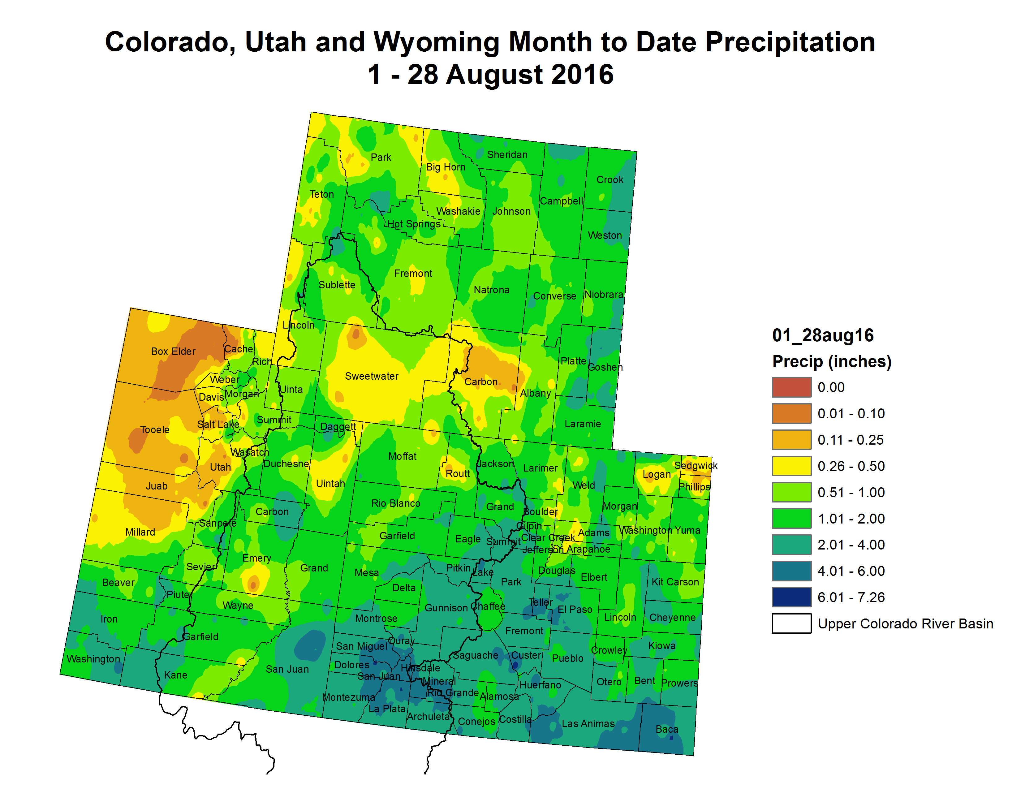
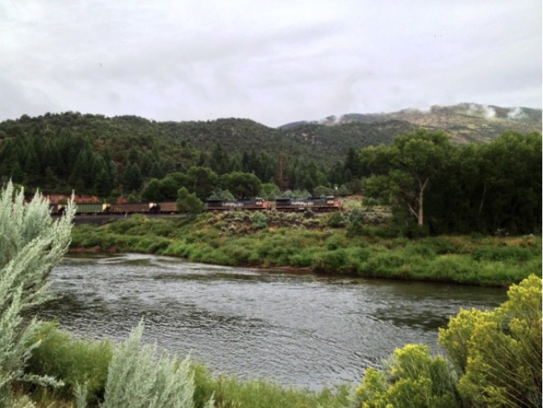

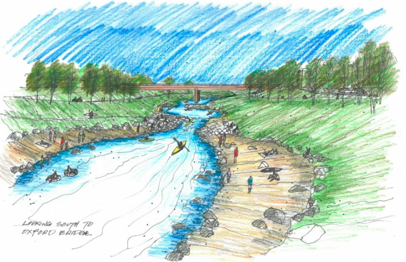

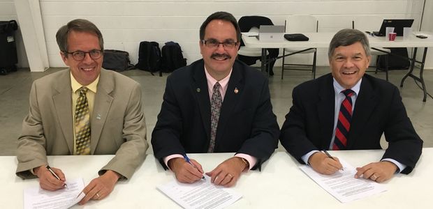
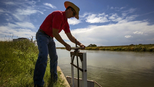

![From left, President François Hollande of France; Laurent Fabius, the French foreign minister; and United Nations Secretary General Ban Ki-moon during the climate change conference [December 2015] in Le Bourget, near Paris. (Credit Francois Mori/Associated Press)](https://coyotegulch.blog/wp-content/uploads/2015/12/francoishollandelaurentfabiusbanki-mooncop21.png)