The yellow-striped chunks of asphalt that cascaded into Coal Creek in the waning days of the summer of 2013 are long gone, while the yawning gap in the road created by rushing floodwaters has once again been spanned.
Still, motorists wait for County Road in Louisville to open to traffic more than three years after it was destroyed in Colorado’s costliest natural disaster.
The reconstruction project just south of the city’s historic downtown, scheduled to wrap up Oct. 15, aptly illustrates the lasting impact the flood of 2013 had — and continues to have — on communities that found themselves in the path of the epic five-day deluge. Last week marked the third anniversary of the deadly storm, which killed 10 people and displaced 18,000 more, destroyed more than 1,800 homes and 200 businesses and racked up costs of nearly $4 billion.
Though the flood has long slipped to the rearview mirrors of most folks, the recovery effort remains strong, said Molly Urbina, executive director of the Colorado Resiliency and Recovery Office.
“The summer of 2016 was a very busy season in flood recovery, as we saw many projects coming out of the ground with a lot of construction activity with housing, roads, bridges and watersheds,” she said. “We saw activity begin to peak this year and will continue through 2017 as the process for various projects continues through engineering, environmental reviews and permitting at the local level.”
Besides the bridge in Louisville, there are two other flood-damaged bridges still out of commission in Boulder County, a road wiped out in Larimer County, a park closed in Evans and tens of millions of dollars worth of permanent repairs needed on miles of roads that thus far have only seen a temporary fix.
Of the $353 million the Federal Emergency Management Agency has given to the state for distribution to local communities tackling major infrastructure repairs, $137 million has been disbursed. The remainder, Urbina said, will be paid out “after completion of eligible activities and submittal of required documentation.”
Which means the mopping up of the mopping up is still several years out.
“The one thing that surprised me is how long this process takes,” said Roy Rudisill, director of emergency management for Weld County.
While all roads in the county are passable, there are at least two major repairs on a bridge and road near Kersey still to go, he said. Work on everything related to the 2013 flood, including reimbursement checks from the government, probably won’t close out until 2018, Rudisill said.
So far, Weld County has been reimbursed $7.5 million of the $10.2 million in expenses it submitted to both FEMA and the Federal Highway Administration (FHWA).
For the small city of Evans, reimbursements from a variety of federal agencies have added up to $3.4 million so far. Spokeswoman Kristan Williams said the city has spent more than $5.7 million recovering from the flood, which sent the South Platte River rushing over its banks and into the city’s neighborhoods.
The biggest impact to Evans residents from the flood was the destruction of Riverside Park, Williams said. A small portion of the park has been refurbished and has reopened, but the bulk of the 100-acre facility is not yet usable. It won’t be until 2018, she said.
“This park has been the venue for baseball tournaments and festivals and is deeply missed in our community,” Williams said. “Thousands of hours have been spent by the city to plan, design and work with federal and state agencies to be able to reopen. It is extremely complex and challenging to convey that it isn’t a matter of putting on gloves and picking up trash to be able to reopen it.”
At least $2 million is needed to get Riverside Park back in order, Williams said, but securing funds from a variety of state and federal agencies is no easy task.
“There is a process you follow to make sure you get reimbursed,” she said.
“The process was lengthy”
That process can be painstaking. Longmont, which is eligible for $55 million in FEMA reimbursements for damage to its bridges, roads, wastewater treatment plant and the St. Vrain River itself, has assigned half a dozen city staffers to gather receipts and put together expense reports for FEMA to vet.
Peter Gibbons was hired by Longmont in March to head up the city’s recovery division.
“It doesn’t work as, like, you get this big blank check,” he told the Longmont Times-Call this month. “You get a $55 million obligation, which means, ‘We’re going to give you $55 million as long as you do all the things you said you’re going to do.’ ”
That process is a big reason Louisville’s County Road bridge took so long to rebuild. City Manager Malcolm Fleming said the bridge was not as high a priority as were some other critical flood recovery efforts in Boulder County, but the $3.2 million project was also subject to federal and state procedures and review guidelines.
“The process was lengthy, and residents have expressed frustration with how long project has taken,” Fleming said. “However, to get the FHWA funding, we had to operate within the FHWA’s constraints on the design, bidding and construction process, which took time.”
The new bridge couldn’t come any sooner for Myra Chapman, a seven-year Louisville resident enjoying a late morning at Community Park last week. She said the rush-hour backups on State Highway 42 from cars trying to take a left onto Pine Street are getting old. Restoring the County Road link to downtown is vital.
“You have to wait three light cycles before you can turn,” she said. “It’s been a very long time.”
A very long time is something many Boulder County residents, especially those living in the foothills, know a lot about. Roadways paralleling rivers in steep, narrow canyons took the biggest hit, as torrents of water barreled through the narrow passages desperately seeking lower elevation in as little time as possible.
Giant machines moved dirt and rock last week along Lefthand Canyon Drive, just east of where Lee Hill Drive intersects with the mountainous road. Boulder County Transportation spokesman Andy Barth said the work is part of $30 million to $40 million worth of road reconstruction projects expected to be completed in the county in 2017 alone.
“We’ve estimated that we could be in construction until 2019, 2020,” he said.
Boulder County’s roads and bridges took a $150 million hit from the 2013 flood. Barth said $57 million has been spent so far on repairs, with $24.1 million of that total having come back to the county in the form of reimbursements from FEMA or FWHA. There is still nearly $93 million worth of flood-related work to do.
“It wasn’t like the asphalt was just broken — it was scoured down to bedrock,” he said. “This stuff takes a long time.”
It will also take a long time for the resurrection of U.S. 34 west of Loveland, where a 3-mile section of the highway will be closed in both directions to all but canyon residents starting Oct. 17 so that major repairs can be performed.
“The canyon section sustained widespread, massive damage,” according to a description of the coming project on the Colorado Department of Transportation website. “Major sections of roadway were washed away completely, along with access bridges and retaining walls. In the narrows, much of the roadway and grade were undermined, washing out the pavement from below and exposing the wall support structures.”
The closure, between Drake and Cedar Cove, will last until Memorial Day weekend.
Signs of progress
While challenges remain plentiful three years after the skies opened to tragic effect, many communities are successfully putting the flood of 2013 behind them one fix at a time.
In Larimer County, the gigantic task of putting County Road 43 back together again — at a cost of $49 million — has come to an end. The months of escorted traffic through multiple blasts zones as crews resuscitated a road swept away by manic waves of water are no more.
The website that for more than a year informed motorists of nearly constant delays on the route between Estes Park and Drake bears a happy, if short-lived, message.
“Because this project is now substantially complete, this website will be taken down in mid-September,” it reads.
Todd Juergens, road and bridge director for Larimer County, said after spending nearly $46 million on flood repairs through the end of August, the county projects it has nearly $55 million left of repairs to do. That includes reconnecting County Road 22H to County Road 29 over the Big Thompson River west of Loveland, a task he thinks will be completed by the end of the year.
“This is what we do,” Juergens said matter-of-factly of the work in front of him.
The residents of hard-hit Jamestown did what they had to do to come back from nearly total destruction. For months after the storm, dozens of residents were unable to return because of flood damage to their houses — if their houses were standing at all.
Tara Schoedinger, Jamestown’s mayor, said even with up to $20 million in damage and a population of about 20 fewer people than there were preflood, her town has emerged as a “strong and more resilient community” three years after the deluge.
The final home to be rebuilt on a once-sodden ground will be unveiled in the spring. And Jamestown proudly shows off its newly built bridge with burly retaining walls on the west end of town.
Urbina, the head of Colorado’s recovery office, said other postflood accomplishments are worth noting.
More than 100 affordable housing units in flood-impacted communities have been built, many of which are available for residents displaced by the flood. One hundred sixty-nine businesses and farms in Colorado have received money through the Community Development Block Grant program. Also, 74 watershed restoration projects in the state will be implemented through the U.S. Department of Agriculture’s Emergency Watershed Protection Program.
“The strength shown by the disaster survivors and the leaders at the local level continues to inspire us, and the state will remain a partner working side by side with them until this recovery is complete,” Urbina said.
2013 Flood recovery by the numbers
FEMA public assistance (infrastructure): $355 million
FEMA individual assistance: $62 million
FEMA reimbursements distributed via the state: $137 million
Total damage from storm: $3.9 billion
Killed: 10
Evacuated: 18,000
Homes destroyed: 1,852
Businesses destroyed: 203
Scott Hummer shows off a fish passage at a North Poudre Irrigation Company diversion structure. His agency worked with Fort Collins Natural Areas and Colorado Parks and Wildlife to include a fish passage when the irrigation company replaced a diversion structure on the Poudre River that was destroyed by the 2013 floods. Work was completed [in February 2016]. (Pamela Johnson / Loveland Reporter-Herald)
Bohn Park was flooded by the St. Vrain River in Lyons, CO September 18, 2013 via Getty Images
Flooding in Longmont September 14, 2013 via the Longmont Times-Call
September 2013 flooding via AWRA Colorado Section Symposium
Colorado Boulevard crossing at Big Dry Creek below the Union Pacific Railroad during the September 2013 flood
Left Hand Creek September 2013 via Piper Bayard
St. Vrain River floodplain November 2013 via the Longmont Times-Call
Air search for flood victims September 2013 via Pediment Publishing
Flooding St. Vrain River September, 2013 via Voice of America
Evergreen Colorado Flooding September 2013 via Business Insider
New Saint Vrain River channel after the September 2013 floods — photo via the Longmont Times-Call
Flood damage Big Thompson Canyon September 2013 — photo via Northern Water
Flooded corn crop September 2013.
Production fluids leak into surface water September 2013 — Photo/The Denver Post
Temperature outlook through December 31, 2016 via the Climate Prediction Center.Precipitation outlook through December 31, 2016 via the Climate Prediction Center.Drought outlook through December 31, 2016 via the Climate Prediction Center.
A resolute effort in Arizona, California, and Nevada to reduce Colorado River water use is slowing the decline of Lake Mead and delaying mandatory restrictions on water withdrawals from the drying basin.
The Bureau of Reclamation, the federal agency that oversees lake levels, forecasts that Arizona, California, and Nevada will draw less than 7 million acre-feet from the river this year, some 500,000 acre-feet less than they are permitted to consume and the lowest since 1992. (An acre-foot is 325,851 gallons, enough water to flood an acre of land with one foot of water.) At Lake Mead’s current water level, 500,000 acre-feet equals slightly more than six feet in elevation — just enough water to tip the lake into shortage levels, if it had been used.
The savings have been building. Four major conservation programs since 2014 have added roughly 10 feet of water to Lake Mead since 2014, according to Rose Davis, spokeswoman for the Bureau of Reclamation’s Lower Colorado Office. These programs, collaborations between federal, state, and local agencies, pay farmers not to grow crops, line earthen canals with concrete to prevent leaks, remove grass from golf courses, or install more efficient irrigation equipment. The savings are banked in Lake Mead.
“These programs are working,” Davis told Circle of Blue. “These partnerships are working. They are making a difference.”
The August analysis of the basin’s hydrology, an assessment carried out every month by the Bureau of Reclamation, concluded that the water level in Lake Mead will be above 1,075 feet in elevation next January. Those dates are important because the August study determines how much water the Bureau will release from Lake Powell into Lake Mead the following year and whether there will be a shortage in the three lower basin states. A shortage, which has never been declared, happens when the August study shows that Lake Mead will be below 1,075 feet in January. That will not happen next year. The lake’s forecasted water level in January is 1,080 feet.
The benefits of conservation spread beyond next year. The risk of a shortage in the near-term will go down. The last time the Bureau ran the numbers, in April, the results showed a 56 percent chance of shortage for 2018. The updated calculations, which will be published next week, will show “greatly reduced odds,” Davis said.
Water managers in the basin say that conservation gains can be maintained and extended. “All of the programs are long-term, reaching out several decades,” Tanya Trujillo, executive director of the Colorado River Board of California, told Circle of Blue.
More Challenges Still To Come
Even with the conservation success, hard decisions are close at hand. One, the basin must come to terms with the “structural deficit.” This is the term water managers use to describe a basic imbalance: in a year with average water releases from Lake Powell, the water level at Lake Mead will drop by roughly 12 feet because demand exceeds supply. James Eklund, director of the Colorado Water Conservation Board, called the structural deficit “a root discussion over the last several years” among all seven basin states.
Two, the risk calculations will change as the four states in the upper basin — Colorado, New Mexico, Utah, and Wyoming — pull more water out of the basin.
Three, water managers and politicians alike must figure out what to do about the Salton Sea, a festering sore in the basin’s politics. The sea — in fact, a lake — was created in 1905 when the Colorado River burst through a dike and filled a desert depression that had no ocean outlet. In later years, the Salton, now California’s largest lake, swelled with farm drainage and grew saltier from evaporation.
The Salton has been shrinking since 2003, when a historic agreement between Imperial Irrigation District and state, federal, and tribal agencies resulted in a large transfer of water from farm to city, which reduced farm runoff. As part of the agreement, Imperial delivered water to prop up the lake, which is also an important habitat for birds migrating along the Pacific flyway. But those deliveries will cease at the end of 2017, after which the lake will go into a tailspin, shrinking rapidly and becoming several times saltier than the ocean. Pesticides, salts, and toxic dust on the seabed poses an immediate health threat to the people of the Coachella Valley, Imperial County, and Mexicali, a border city of 1 million people. A solution to the Salton Sea problem is inevitably tied to Colorado River issues upstream.
“Being one of the largest users on the river, it’s in our best interest to look out for and promote the health and welfare of the system as a whole,” Marion Champion, spokeswoman for Imperial Irrigation District, told Circle of Blue. “That said, we will need some reassurances from the state of California that it will live up to its restoration promises for the Salton Sea.”
Imperial has the largest allocation of Colorado River water — 3.1 million acre-feet, more than one-fifth of the river’s average annual runoff — of any user in the basin. Champion said that she expects Imperial to be a part of a basin-wide drought plan, but only if the Salton Sea is addressed, with either money or water, or both.
“That participation is contingent on a state led restoration plan and implementation commitment to ensure our community’s public health is protected,” she said.
Students from Estes Park High School teamed up with ecology experts from the Estes Valley Watershed Coalition on Wednesday to help rebuild the ecosystem along lower Fish Creek. That area was devastated by the flood in 2013, washing away vegetation, eroding the banks, destroying the utility infrastructure, and damaging homes.
The Coalition has been working for the last year to restore areas damaged by the flood. They selected this area of Fish Creek as their first project, according to Molly Mills, Coordinator of the Coalition. Nearly a year ago, she met with Chuck Scott, principal of the high school, and asked if the Coalition could work on restoring the river banks adjoining school property.
“I asked him for permission to work on school property,” she recalled, “and he said, ‘Only if you involve the kids and make this a learning experience,'” said Mills.
Mills agreed at once to the plan, and she took the responsibility for securing grant funding and obtaining legal permission to work on the river banks. That required several months, since there are numerous overlapping jurisdictions involved in the Fish Creek watershed.
With guidance from teacher Alex Harris, the high school’s Environmental Club began planning and recruiting their classmates for this event. Mills did some training with the students, teaching them about riverine ecology, and the proper techniques for planting trees. The students in the club then created training materials for the student volunteers.
“This has been a student-run project the whole way,” said Mills. “I brought the idea to them, and the funding; they organized the volunteers, mapped it out, and got the logistical support.”
[…]
Beginning early in the morning on Wednesday, students transported plants and supplies in pickup trucks to three areas along Fish Creek. More than 300 students arrived and split into teams to get to work on the riverbank. They began by pulling and bagging noxious weeks that have proliferated since the flood. They also cleared the banks of accumulated flood debris and trash.
The Coalition brought in 3,000 trees, provided by the Colorado State Forest Service. The specific species had been selected by Mills in consultation with ecology experts. They included river birch, alder, chokecherry, and cottonwood. Mills’s ecology consultants marked the locations for each tree. Working in teams, the students dug holes, planted the trees, and carried buckets of water from Fish Creek to water them.
Nearly the entire student body has been involved in this project, including the Culinary Arts class, which planned and prepared lunch for the students, teachers and volunteers. Students in the Film Studies are making a documentary to tell the story of the project. The faculty and administrators also supported the project…
Randy Mandel, representing the Colorado Water Conservation Board, walked among the groups of students. A water and ecology specialist, Mandel explained to the students how their efforts would improve the watershed. Mandel noticed a student struggling with the root ball of a tree. He bent down and guided her in the proper technique.
Gary Miller, President of the Coalition, said that the flood impacted Fish Creek more severely than any other area in the Estes Valley, and therefore was chosen as the first project.
“The Coalition was formed to bring together organizations interested in sustainable restoration of the flood damaged areas,” he said. The Estes Valley has seen three 500 year floods since 1979, and Miler predicted that we should expect more in the future. “We need to be prepared for the next huge event,” he said. He pointed out that this project has served to educate the students about the broader problem of environmental disasters.
Mills said that this is the first phase of the revegetation of the Fish Creek watershed. The next phase will be putting up fencing around the young trees to encourage the elk and deer to browse elsewhere.
“Otherwise,” she said, “they will eat everything we’ve planted.”
In the next few months, the Coalition will be mulching the area and broadcasting native grass seeds to improve the ground cover.
The City of La Junta has received a $5,000.00 matching grant from the Colorado Department of Public Health and Environment to help with the development and implementation of a Source Water Protection Plan (SWPP) for their drinking water intakes. The development of a SWPP involves identifying a source water protection area; creating an inventory of potential contaminants to the drinking water; and developing best management practices (BMPs) to help mitigate those potential contaminants.
Colorado’s Source Water Protection program is completely voluntary, and is designed to help public water systems take preventive measures to keep their sources of drinking water free from potential contaminants. This program does not impose any new regulations on the use of personal properties. Rather than developing new regulations to enforce, the main goal of developing the SWPP is to raise awareness within communities about the importance of source water protection. The program is founded on the concept that informed citizens, equipped with fundamental knowledge about their drinking water source(s) and the threats to it, will be the most effective advocates for protecting this valuable resource.
Kimberly Mihelich, a Source Water Specialist with the Colorado Rural Water Association (CRWA), will be helping with the coordination and facilitation of this process. CRWA is a nonprofit organization and receives funding from state and federal agencies to help communities with source water protection and other technical issues water systems face.
The planning process will take place during a one four-hour workshop on Thursday, Oct. 6, from 10 a.m. to 2 p.m. in the City Council Chambers of La Junta’s Municipal Building (601 Colorado Avenue, La Junta, CO 81050). Lunch will be provided. Interested community members are invited to attend. For further information please contact Tom Seaba (City of La Junta) at (719) 469-6636, Joe Kelly (City of La Junta) at 384-7358, or Kimberly Mihelich (CRWA) at (719) 248-9116.
The Environmental Protection Agency is awarding another round of grants — this time totaling $260,000 — toward cleanup costs and response to the Gold King Mine spill in southwestern Colorado.
The funding will be distributed, according to a media release from the office of Sen. Cory Gardner, as follows: Southern Ute Indian Tribe, $58,684; La Plata County, $7,495; City of Durango, $9,993; San Juan County, $80,213; San Juan Basin Health Department, $4,591; and the Colorado Department of Public Health and Environment, $101,465.
According to EPA records, with the addition of the most recent award, San Juan County has received a total of $349,409. San Juan County Administrator Willy Tookey could not be reached for comment, but based on agency records and previous interviews, that leaves about $10,000 outstanding…
The agency has paid $377,073 to La Plata County and $55,464 to the city of Durango, EPA records show.
But local and state leaders say the money hasn’t come fast enough; the EPA’s latest award comes two weeks after a bipartisan group of senators from the four impacted states backed a measure to expedite reimbursements to entities affected by the spill.
The provision was incorporated within the Water Resources Development Act this month. It requires the EPA to reimburse claims within 90 days if the costs are deemed in accordance with federal law and establishes a long-term water quality monitoring program for which the EPA is authorized to reimburse local entities and tribes.
“The announcement of this additional funding is a step in the right direction as Southwest Colorado continues to deal with the aftermath of this disaster,” U.S. Sen. Michael Bennet, R-Colo., said in a statement. “Two weeks ago, we passed a bipartisan amendment in the Senate that required the EPA to fully reimburse the state, tribes and local communities who responded quickly to the spill. We are pleased that the EPA responded with these additional reimbursements, and we will continue to push the agency to complete the reimbursement process as soon as possible.”
[…]
EPA spokeswoman Laura Jenkins said the $262,000 sum was awarded through cooperative agreements that local entities struck with the federal agency. Jenkins said no companies or individuals who have filed claims have been reimbursed to date.
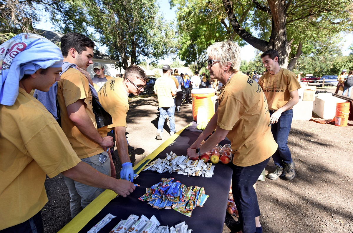
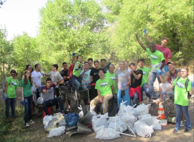
More than 350 members of the Colorado College community participated in a local day of service, cleaning up trash along neighboring Monument Creek. Participants worked in two-hour shifts and collected a total of 3,140 pounds of trash from both sides of a two-mile stretch of the creek.
The daylong event, sponsored by CC’s Collaborative for Community Engagement, EnAct, and the Regional Business Alliance, brought out CC faculty, students, and staff, as well as neighbors and area alumni.
The lure of the water and the potential of the area appealed to many, including those who went as part of a CC class called Re-enchanting the World: Reality in Ecological Perspective, co-taught by mathematician Mike Siddoway and theologian Phil Devenish. Among them:
Cassie Cohen ’17, a psychology major from Lincoln, Massachusetts, says she wanted to help clean up the creek “because it feels like a part of our campus.”
Leah Di Filippo ’17, an economics major from Gladstone, New Jersey, says cleaning the watershed area “will help change how it’s viewed and how it’s branded.”
Ben Garinther ’17, a fly fisherman from Baltimore with a self-designed major in environmental philosophy, says “This creek should be valued more. It would be unreal to come down here and fish in Monument Creek.”
Rebecca Glazer ’18 from San Francisco with a self-designed major in philosophies of sustainable development, says “It’s important. CC has a responsibility for the waterway that flows through it.”
Local alumna Carrie Ryden ’95, MAT ’96 joined the cleanup effort, along with husband Doug and 9-year-old daughter Hazel. “It’s something we can all do together as a family, and the fact that we’re doing it as part of a community is even better,” she says.
Other communities were represented as well. All six Greek life organizations on campus participated, and well as nine Colorado College athletic teams, including men and women’s lacrosse, women’s basketball, men’s soccer, cross-country, tennis, women’s rugby, Nordic skiing, and swimming and diving.
A variety of student organizations joined the effort, including Mortar Board, CC’s Student Government Association, President’s Council, Chinese Students Association, Community Engaged Scholars, and Boettcher Scholars. Entire CC offices had strong showings, including Human Resources, the Career Center, and Communications. Colorado College President Jill Tiefenthaler was on site during the afternoon, handing out water and a variety of snacks to the volunteers.
Community members got involved as well, with participants from the Pikes Peak Area Council of Governments, Regional Business Alliance, Old North End Neighborhood, Steele Elementary School, Palmer High School, and Patty Jewett Neighborhood Association.
Jake Walden ’16, a fellow in the President’s Office and lead coordinator on campus for the effort, said he was pleased with the enthusiastic turnout. The event was capped off by a community barbecue for volunteers, which was hosted by members of EnAct, a CC student environmental organization, and paid for by the CC Student Government Association.
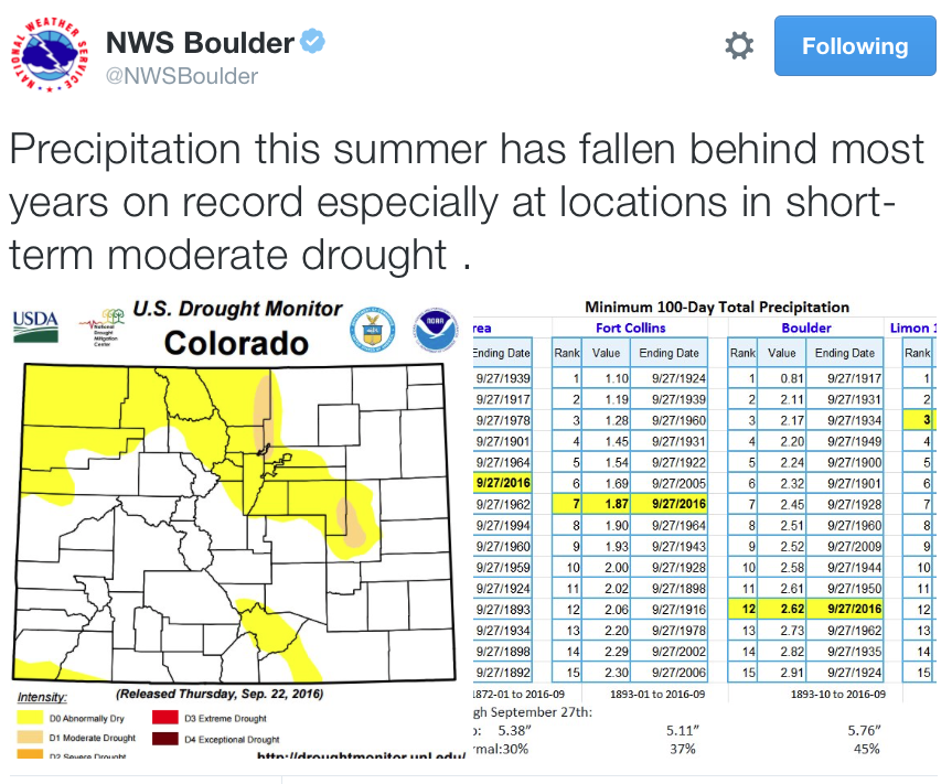
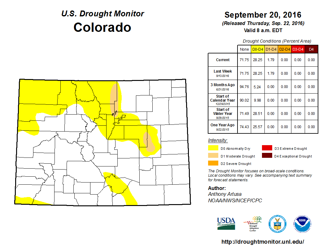
According to the U.S. Drought Monitor, Denver’s northern and eastern suburbs have been added into a growing area of moderate drought, which now extends from Aurora to Fort Collins.
A second area of moderate drought was developing in east-central Colorado on the eastern side of the Palmer Divide.
Moderate drought means damage has been reported to crops or pastures and that water shortages are either developing or could be imminent.
A large part of northwest Colorado remains abnormally dry, or in pre-drought, along with some of the mountains in southern Colorado.
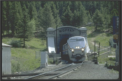
The discharge is occurring at a location very near the Moffat Tunnel and is derived from a culvert located beneath a set of metal stairs that descend right to the banks of the Fraser.
The UPRR has a permit from the Colorado Department of Public Health and Environment (CDPHE) officially allowing the discharge of the water, but correspondence between Grand County officials and representatives from the CDPHE indicates the current level of pollutants being released are not allowed under the existing permit.
In correspondence with state officials Grand County has stated the organic compounds found in the discharge are toxic and some are carcinogenic. Emails written by Grand County Water Quality Specialist Katherine Morris to officials from the CDPHE states, “the Railroad has classically discharged these organics, without disclosure to the state, in high concentration pulses which escape routine sampling. The existing and proposed permits do not currently include any organics, let alone include limitations for these.”
Emails sent by Morris to officials from the CDPHE on Wednesday Sept. 28 state, “I hope the CDPHE will have the opportunity to investigate this case further and address this specific source of contamination.” Officials have also sent photographs to the CDPHE of the point of discharge that show dark, black, almost opaque water flowing from the discharge culvert into the Fraser. The photos appear to have been taken on Sept. 14, 2016.
Notably, a letter sent on Sept. 19 by Morris to the State’s Clean Water Enforcement Unit, a division within the CDPHE, states, “The Railroad curtailed the polluted discharge by 5:00 pm on the same day that that we were notified of the pollution.”
Correspondence between Morris and CDPHE officials indicates the permit allowing the discharge of water into the Fraser by the UPRR has been in existence since 2007. Additional email correspondence between Morris and State water officials states, “UPRR has stated that this discharge is associated with annual maintenance activities, and the Railroad has declined to report the discharge as a spill. However, nothing in the permit indicates that pollution of this level is permitted, and it would seem to be a violation of their permit.”
A water treatment plant, to treat the water discharged into the Fraser by the UPRR, is currently under construction, according to a letter sent to the CDPHE by Grand County in late June regarding a draft permit for the UPRR’s Moffat Tunnel West Portal.
The letter goes on to state, “To the best of Grand County’s knowledge, there is and has been no treatment of this discharge prior to release to the Fraser River.” The letter also points out that state regulations state, “state water shall be free from substances attributable to human-caused point source or nonpoint source discharge in amounts, concentrations or combinations which are harmful to beneficial uses or toxic to humans, animals, plants or aquatic life.”
The letter goes on to state that the County, East Grand Water Quality Board and the Town of Winter Park conducted sediment and aqueous testing in Oct. 2015 but that such testing occurred too late after the August cleaning operations to, “indicate the presence of more than one volatile organic carbon (toluene) or significant concentrations of suspended or dissolved contaminants in the aqueous samples.” Samples were collected at sites 287 feet upstream from the discharge point and 2,138 feet downstream.
The letter does state the downstream samples, “indicate the presence of several semi-volatile organic carbons (SVOCs) and diesel range organics (DROs) that are either not present in the upstream samples (SVOCs), or are present at significantly higher concentrations downstream compared to upstream (DROs) indicating that their presence is a direct result of the tunnel discharge.” The letter noted the lab that tested the samples indicated the existing sediment matrix downstream from the discharge point was, “complex and likely to have a number of interferences.”
Fish in the Fraser River have struggled because there was too little water for the riparian area that had been created by natural flows. Segments have now been mechanically manipulated to be more narrow. Photo/Allen Best.
Each year, the Parks and Wildlife department conducts an annual survey of fish populations in different stretches of the Animas River. Recently, crews focused on the portion of the river from the bridge behind Durango High School to High Bridge, near the La Plata County Humane Society.
For more than a decade, fish populations in the Animas have been on a steady decline, attributed to a number of factors, including less water in the river, urban runoff, higher water temperatures and elevated levels of heavy metals.
As a result, Parks and Wildlife stocks about 20,000 brown and 20,000 rainbow fingerlings a year, which usually have a survival rate of 3 to 5 percent, about the state average.
Although White said this year’s count didn’t indicate a turning point for fish in the Animas, he did say certain population trends are encouraging.
“The good news is we captured twice as many fish of quality size – 14 inches or better – compared to last year, so that’s really good,” he said.
White said another positive sign was crews caught a lot of 2-year-old brown trout, which means more juvenile fish stocked last year survived winter.
“We haven’t seen that recruitment for a while,” White said. “We also saw a higher number of larger rainbow trout. We’ve seen lots of small fish over the years that don’t seem to make it through the winter, but this year we’re seeing a lot more relative to the past several years.”
White said it would take a couple weeks to generate a population estimate, but he expects that number to reach or be very close to the Gold Metal Standard the river currently holds on the 4-mile stretch between the confluence with Lightner Creek and the bridge near Home Depot that contains 60 pounds of trout per acre and at least 12 14-inch or larger trout per acre.
After overcoming equipment problems and putting in 24-hour work days, crews on Wednesday were within 35 feet of reaching the end of what will be a 764-foot-long tunnel.
“We’ve made tremendous progress …,” said Owen Randall, chief engineer with Fort Collins Utilities. “We should be out sometime (Thursday) or Friday at the very latest.”
Breaking through the mountain will be done slowly and carefully to avoid destabilizing the mountainside, he said.
Crews still have four to six weeks of work to wrap up the project, which will carry Michigan Ditch and its valuable water to city-owned Joe Wright Reservoir near Cameron Pass.
Dismantling and removing a custom-built tunnel boring machine from the mountain will take three to four days. Hydraulic and electronic equipment used to operate the machine will be stripped from the tunnel before a 60-inch diameter pipe is installed to carry the water.
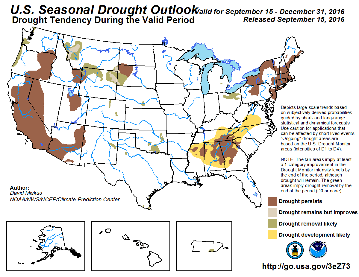
Click here to go to the US Drought Monitor website. Here’s an excerpt:
Summary
For the USDM 7-day period ending on September 27, a low pressure system produced above-normal precipitation in the western High Plains southwestward into the much of the Mountain West. The frontal boundary that was associated with the low produced copious amounts of rainfall for the Southern Plains stretching northward into Upper Midwest. Parts of the Mid-Atlantic also saw above-normal precipitation for the period. Drier-than-normal conditions existed for much of the country east of the Mississippi, especially for the Ohio Valley. Temperatures were as much as 10 degrees above normal for the parts of the Midwest while the Southwest and Northwest were cooler than normal. These warm and dry conditions in the nation’s eastern half contributed to expansion of drought in the Northeast and Southeast, while drought conditions improved in the High Plains and parts of the South. Please note that the Drought Monitor depicts conditions valid through Tuesday morning, 8 a.m., EDT (12 UTC); any of the recent locally heavy rain which fell after Tuesday morning (September 27) will be incorporated into next week’s drought assessment…
High Plains and Midwest
In the middle of the USDM period, an inch of rainfall fell in the drought stricken areas of the High Plains. As a result, short term dryness was removed in northwest North Dakota and multiple levels of drought were contracted in western South Dakota. It was reported that some small grasses have greened up and winter wheat planting is going full steam ahead. However, an extended dry period in the northeastern part of South Dakota kicked off the soybean harvest, and harvest activities should increase this coming week. Precipitation during the last 30-days in Montana and Wyoming was much above normal, which contributed to improved conditions in southern Montana, western Wyoming and eastern Idaho. Streamflow levels at 7 and 14 days were at or above average, while the 30-day percent of normal precipitation was more than 200 percent of normal…
Southwest
In Colorado, below normal precipitation during the past 30 days was reflected in the low streamflows, resulting in a small expansion of D0 in the central part of the state. Stations in and around Denver were showing near-extreme to extreme dryness at the 3-4 month time scale, resulting in the expansion of D0 and D1 in the area. Due to the unseasonably high precipitation totals in eastern Utah, SPIs have shifted from negative to positive through the six month timescales. It was reported that the benefits of this could be seen in both the soils and streams…
West
It is the dry season in much of the western U.S. , so no changes were made during this USDM shift…
Looking Ahead
During the next few days, a strong upper level low pressure system stalls out over the Ohio Valley providing much needed drought to the Mid-Atlantic region. As much as 3-6 inches of rain is forecasted, so flooding and flash flooding is possible in some areas. Some of the areas that were placed in D0 status this USDM week may see several inches of rain from this event. Please note that the Drought Monitor depicts conditions valid through Tuesday morning, 8 a.m., EDT (12 UTC); any of the recent locally heavy rain which fell after Tuesday morning (September 27) will be incorporated into next week’s drought assessment. Meanwhile, the rest of the CONUS will be relatively quiet. For average temperatures during the next few days, the largest positive anomalies are forecasted to occur in the West, Northwest, and High Plains. The largest negative anomalies should be concentrated in the Midwest and are forecasted to gradually slide southward. For the second half of the next USDM period, much cooler than normal temperatures return to the West Coast, while the warmer than normal temperatures are confined to much of the area east of the Rockies. The 6-10 day outlooks from CPC show an increase probability of warmer than normal temperatures for the eastern half of the country and the western half has the best chance of cooler than normal temperatures. There is an increased probability that above normal precipitation will fall in the Northern Rockies and High Plains while the probability is best for below normal precipitation to occur in the Southeast.
Here’s the release from Wyoming Governor Matt Mead’s office:
Wyoming and 26 other states, industry groups and others presented arguments before the D.C. Circuit Court of Appeals on Tuesday in opposition to the Clean Power Plan. The states argued the proposed rule goes far beyond the Environmental Protection Agency’s (EPA) authority. Wyoming would be particularly impacted as the rule requires the state to reduce its carbon dioxide emissions by 44%.
“Federal regulatory agencies continue to push the boundaries of their legal authority. This results in unreasonable and onerous burdens on industry, businesses, individuals and states,” said Governor Matt Mead. “The Clean Power Plan is just such a situation. I am pleased the Court stopped the implementation of the rule pending a decision in this case.”
Earlier this year, the D.C. Circuit denied a petition from states to halt implementation of the rule while litigation was pending. The petition was then submitted to the U.S. Supreme Court which ultimately granted the stay and stopped implementation of the rule. The petition argued the EPA did not have the proper authority, the Clean Power Plan would take authority away from states to regulate in-state power generation and transmission and the final rule was substantially different from its draft version, a violation of the Administrative Procedure Act.
Click here to read the newsletter. Here’s an excerpt:
COLORADO RIVER RISK STUDY
The Colorado River District has released a memo summarizing the results of the first phase of the Joint West Slope Roundtables Risk Study. This study looked at the potential for Lake Powell to hit critically low levels under different hydrologic and demand scenarios. The memo outlines additional work to be done in Phase 2, including an exploration of how different management options could affect water users and sub-basins.
Avon photo via Jack Affleck and the Mountain Town News.
Click here for all the inside skinny about the conference:
Our annual conference expands cooperation and collaboration throughout Colorado in natural resource conservation, protection, and enhancement by informing participants about new issues and innovative projects. In 2016, the conference will focus on what is needed to help ensure long-term sustainability for river health, public education, and organizational management.
The first time I saw the channel of the Rio Grande completely dry, I was stunned. Here was the second largest river in the Southwest, which flows through three U.S. states and Mexico, and instead of water between its banks there were tire tracks. And I wasn’t standing at the tail end of the river, but rather on a bridge in central New Mexico, in the Rio Grande’s middle reach. For a freshwater conservationist, it was a sad sight.
Even worse, it was not an aberration. Each year, portions of the Middle Rio Grande dry up when its flows are diverted into irrigation canals for delivery to farmers in the valley. A few miles of the channel might dry up for a couple of weeks, or, if the monsoon rains are disappointing and irrigation demands are high, the dry stretch might extend thirty or more miles for much of the summer. Either way, for a time the river is no more.
So earlier this year when I learned about an innovative idea spearheaded by Audubon New Mexico to return some flow to the Rio Grande at its driest time of year, I felt a surge of hope for the river and the life it supports—from native fish like the Rio Grande silvery minnow to birds like the Southwestern Willow flycatcher, both federally endangered and dependent on the Rio Grande for habitat.
Audubon New Mexico, a Santa Fe-based non-profit conservation organization, had reached out to Native American tribes in the Middle Rio Grande Valley with a proposition: if the tribes transfer to Audubon a portion of their allotted water from the San Juan-Chama diversion project, which brings New Mexico’s share of Colorado River water into the state, Audubon would ensure that the water benefits the Rio Grande and seek funding for habitat restoration on tribal lands.
The idea struck a positive chord with a number of the tribes, and a unique partnership was born. Two pueblos, Isleta and Sandia, decided to donate their water, while Cochiti and Santa Ana agreed to a transactional transfer. Before summer, the 400 acre-feet from the four tribes was augmented by a nearly equal donation of surplus water by the Club at Las Campanas, a private Santa Fe golf club, bringing the total volume of water to benefit the Rio Grande to nearly 800 acre-feet, or more than 260 million gallons (980 million liters).
“We will increase flow in the river channel for a 35-mile stretch for nearly 24 days,” said Julie Weinstein, Audubon New Mexico’s Executive Director, in a statement earlier this month. The organization worked closely with the Middle Rio Grande Conservancy District to determine the best sites to deliver water back to the river to maximize ecological value.
The Rio Grande’s corridor through New Mexico supports over 200,000 waterfowl and 18,000 greater sandhill cranes. It provides the largest number of contiguous breeding territories for both the endangered flycatcher and the threatened Yellow-billed Cuckoo in their entire range.
With over 80 percent of the wetland and riparian habitat gone along the river in New Mexico, sustaining and rebuilding habitat is crucial. As part of this collaboration with Audubon, the Pueblo of Santa Ana is planting trees and restoring habitat along the river.
The San Juan National Forest hired Durango contractors G2 and AJ Construction to complete 500 feet of streambank stabilization in preparation for reintroduction of native Colorado River cutthroat on a stretch of the creek where non-native fish have been removed.
“It’s important to conduct these operations at times when we have low flows and no fish,” said Clay Kampf, fisheries biologist for the San Juan National Forest Columbine District. “We started at the headwaters of each tributary and worked our way downstream to make sure there were always other fishing opportunities.”
Under the direction of Kampf, Grady James, equipment operator with AJ Construction, spent September maneuvering rocks and logs into place to reinforce streambanks and create small waterfalls and deep pools. The goals were clean water and a diversity of habitat for all seasons.
“When the creek takes a corner, and an unstable bank erodes, sediment washes into the water and impacts the ability of fish to survive in many ways,” Kampf said. “Corners are high-stress points so we place large rocks there to protect the banks during higher flows.”
This fall’s water level was only about three to five cubic feet per second, which offered an opportune time to conduct improvements, but the project was designed for a wide diversity of flows. While spring flows of up to 40 to 50 cfs in the East Fork of Hermosa Creek threaten habitat by eroding the banks, very low flows in winter also endanger the fish.
“Keeping water moving in winter keeps it from freezing, which has been the biggest limiting factor for long-term cutthroat survival,” Kampf said. “Constricting the channel and creating small pour-overs increase the winter flow levels.”
Buried logs are effective for stabilizing banks where the stream splits and creates shallow stretches that offer spawning habitat in the spring. But where the creek had divided into multiple channels, rocks were used to divert water back into the main channel to keep flows steady.
Encouraging vegetation is also important for stream stabilization. When the heavy equipment scooped up grass and forbs to make way for placement of rocks and logs, its giant claw replanted the native vegetation with the skill of a seasoned gardener.
“We retain any disturbed vegetation and replant it nearby,” Kampf said. “We avoid disturbing any established willows, which in this stretch are about five to 10 years old.”
North American beaver (Castor canadensis)
Kampf also hopes nature’s furry engineers will return to the area and help with recovery.
“There were beavers, but they moved upstream and downstream during disturbance from the project,” Kampf said. “If the beavers return and flood the area, they will create additional overwintering and larger pools for the cutthroat.”
The Forest Service will closely monitor the project area for three years, keeping an eye out for noxious weeds. Volunteers with the Durango Chapter of Trout Unlimited will help the agency later this fall to plant additional native grass and forb seeds and alder/willow cuttings along the banks to further revegetate the area.
“Our goals are to improve water quality and mimic natural features that will aid in the conservation of the Colorado River cutthroat, which will, in turn, improve recreational fishing,” Kampf said.
Proposed Hermosa Creek watershed protection area via The Durango Herald
The Jeffco Board of Public Health has announced it will hosting a meeting with the Indian Hills community to review and discuss the Indian Hills Groundwater Water Quality Modeling Project Report.
The meeting, an initial step of a community engagement process around groundwater quality issues in Indian Hills, will take place at 6:30 p.m. Oct. 4 at the Indian Hills Community Center, 5381 Parmalee Gulch Road.
In 2015, the Board of Public Health contracted Dr. Margaret Herzog, a professional engineer with PH Associates LLC in Lakewood, to develop a groundwater model of the Parmalee Gulch basin using available data to evaluate the impact of existing and potential new septic systems on groundwater, according to a Jeffco Public Health news release. The purpose of the modeling study was to integrate more than 40 years of research in the Turkey Creek watershed and Parmalee Gulch sub-basin, conduct advanced geospatial analysis, and to determine if and how planned and potential development might increase nitrate pollution in groundwater, which serves Indian Hills private wells and the Indian Hills Water District’s public wells.
In Parmalee Gulch, groundwater serves as the primary source of drinking water for many residents of Indian Hills, a residential community of approximately 1,200 people, the release stated.
To protect the groundwater system, a prohibition of septic systems on certain lots in Indian Hills was instituted in 1979 by the county because of elevated nitrate pollution from septic systems in the groundwater, the release stated. Using existing water quality and land-use data, along with simple modeling methods, the modeling project was designed to inform future public health decision-making related to groundwater quality in Indian Hills.
In August, Jeffco Public Health released the Indian Hills Groundwater Water Quality Modeling Project Report to the public and requested written feedback and comments. The public is invited to submit written comments to rlaws@jeffco.us or by mail to Roy Laws, Jefferson County Public Health, 645 Parfet St., Lakewood, CO 80125.
EPA Wants More State Attention on Nutrient Pollution
In a memo to state environmental regulators and water directors, the EPA’s top water official called nutrient pollution “one of the greatest challenges” to the country’s water and a “growing threat” for human health and the economy.
Joel Beauvais, deputy assistant administrator for water, called for greater attention at the state level to nutrient pollution and for more collaborative programs to keep plant vitamins from getting into the water.
If the Federal Emergency Management Agency’s latest floodplain maps go into effect in 2017, Morgan County’s flood risks will look a little different.
As a part of the National Flood Insurance Program, Morgan County’s highest flood risk areas are shown on maps created by FEMA, which help determine property values and insurance rates. For the first time in about 35 years, FEMA has released a new preliminary floodplain map for the county. It introduces several changes to the old map, making the floodplain smaller in some areas and bigger in others.
The map labels areas that are at low, moderate and high risk from flooding, based on the flow rates of nearby rivers. Properties in high-risk areas have higher flood insurance rates and more building restrictions. The last update to Morgan County’s floodplain map was in 1989, while the maps for specific towns like Brush haven’t been updated since 1981.
For some parts of Morgan County, the new flood map isn’t big news. The city of Fort Morgan has always been too elevated to be greatly affected by the floodplain, and Bradley Curtis, the Engineering and Public Works director, said that hasn’t changed.
“It has minimal effects,” he said. “Not a whole lot of developments are affected apart from Riverview Park and the area down by Maverick’s, which we knew about already.”
Parts of Fort Morgan were flooded during the summer, but that was due to heavy rainfall rather than an overflowing river. The FEMA maps only take overflow from nearby rivers into account when predicting flood risks.
For other towns, the re-mapping is a bonus. Much of the town of Wiggins was in the floodplain under the old map, but now it’s considered a low-risk area. Trustee JoAnne Rohn-Cook said she’s delighted by the new map.
“Since the last survey was done, a dike was built west of the town, so I think that helped,” she said.
Many Colorado farmers are implementing some of the latest-and-greatest production methods, aimed at improving efficiency on their farms, protecting our natural resources, and enhancing air and water quality.
And now Colorado Corn wants to honor the producers taking these efforts to new heights.
The organization is seeking applications for its first ever Colorado Farm Stewardship Award.
“It will no doubt be a difficult task to select just one winner, when we know so many of our Colorado farmers are putting extensive time and energy into being excellent stewards of our resources, while also producing our food, fuel and fiber,” said Mark Sponsler, executive director for Colorado Corn. “But while it won’t be easy, we couldn’t be more excited about this new stewardship program. We feel this award will provide a platform for many growers to share their great stories – shining a light on the numerous, forward-thinking, best-management practices taking place on Colorado’s farms.”
The Colorado Farm Stewardship Award winner is expected to be selected by a committee comprised of board member representatives from the Colorado Corn Administrative Committee (CCAC) and Colorado Corn Growers Association (CCGA), as well as other experts in agriculture, conservation and sustainability.
The announcement of the winner will be made during the Colorado Corn Annual Banquet in Yuma on Dec. 7.
In addition to the awards banquet recognition, the winner will be recognized in Colorado Corn’s communications and outreach efforts, and will also receive the organization’s nomination for the National Corn Growers Association (NCGA) Good Steward Recognition – an honor that includes a $10,000 cash award for the winner, among other prizes.
Applicants must be Colorado Corn Growers Association members in good standing, implement conservation-tillage methods, and demonstrate practices related to soil, water or air stewardship.
Applications are due Nov. 18. The application can be found here.
If you have any questions, you can contact Melissa Ralston at mralston@coloradocorn.com, Eric Brown at ebrown@coloradocorn.com, or call our office at (970) 351-8201.
Eliminating the city’s future possibility to build reservoirs that would inundate portions of the Maroon Bells-Snowmass Wilderness would be irresponsible, given the uncertainties presented by climate change, Aspen City Council members said on Tuesday.
The board was unanimous in its direction to file a diligence application that would maintain the city’s water rights, first decreed in 1971, to build dams that would create the reservoirs on upper Maroon and Castle creeks.
“I have no more interest in building these dams than anyone else in this room,” councilman Art Daily said in the work session attended by about a dozen members of the public, most of whom wanted the city to abandon the water rights.
Yet Daily, like the rest of his council colleagues, said he would need more information about how the city could meet future water supply challenges without the dams, before he could agree to sign away a later council’s ability to pursue their development.
“I can’t in good conscious say we are going to drop these rights without knowing what the viable alternatives are,” Daily said, while acknowledging that a future where they would be necessary feels like an “almost unforeseeable possibility.”
[…]
Ann Mullins said she cannot predict what will happen in 50 years, and officials in the city utilities department have noted that the snow pack around Aspen could look very different under some climate projection scenarios.
“I think it’s the unpredictable part of climate change that is probably the scariest,” she said…
Council members were clear that the city will continue to study alternative water management strategies that will hopefully preclude the need to ever build the dams. This includes increasing conservation and pursuing other supply and storage initiatives.
Within the next year or two, for example, the city hopes to pump treated wastewater from the Aspen Consolidated Sanitation District up hill from the treatment plant near the Aspen Business Center to irrigate the municipal golf course. The city is also exploring developing water supply from deep-underground wells…
Opposition strategies
Numerous parties, including environmental groups, stream-side property owners and the U.S. Forest Service have indicated they will file statements of opposition to the diligence application should it go forward.
Will Roush, conservation director at Wilderness Workshop, made the case at Tuesday’s meeting that the Maroon Bells are too important a resource to keep the possibility of the dams alive. The regulatory hurdles the city would encounter if it ever tried to develop the reservoirs would be too extreme, and would require an exemption signed by the president to federal wilderness area rules, Roush has said previously.
Paul Noto, a local attorney who is working on behalf of the conservation group American Rivers, said that once the application is before a water court judge, the discussion will enter a new phase. A judge would approve any amendment to the water rights that was mutually agreeable to the city and opposing parties, Noto said.
That means changes to the size and placement of the dams and reservoirs would be on the table. Noto, who argued Tuesday that the city doesn’t need the water that would be stored behind these dams, said there’s a strong possibility that the size of the would-be reservoirs is in for a “substantial haircut” in the water-court process.
All Security Water District customers are now using Perflourinated Chemical (PFC) free surface water. According to Security Water officials, the surface water is brought in from the Pueblo Reservoir. Groundwater wells in the area have been shut down since the EPA found elevated levels of PFC’s, a man-made chemical, in water sources used by Fountain, Security, and Widefield.
The US Air Force plans on changing the type of firefighting foam it uses because of concerns that the foam is responsible for the water contamination.
The move by Security Water and Sanitation Districts signaled the last time that contaminated water is expected to reach residents’ homes, said Roy Heald, the water district’s general manager.
“We’re confident now that we can maintain this, really, until we can get treatment online,” Heald said.
Security’s announcement comes as temperatures cool and the summer watering season comes to a close.
Water districts in Security, Widefield and Fountain have traditionally relied largely on surface water pumped into the area from the Pueblo Reservoir during winter months. However, those water districts relied much more heavily on the Widefield aquifer during the spring and summer months to meet demand.
That strategy became a problem in May when the Environmental Protection Agency tightened its guidelines over perfluorinated compounds and left residents in Security, Widefield and Fountain scrambling to find other water sources.
Fountain managed to go the entire summer without dipping into the aquifer, due largely to watering restrictions.
Widefield Water and Sanitation District, however, does not expect to completely wean itself from the contaminated aquifer until “sometime in October,” according to Brandon Bernard, Widefield’s water department manager.
In Security, multiple projects are underway to ensure the chemicals no longer get into the drinking water, Heald said.
This year, the district purchased extra surface water from Colorado Springs Utilities to limit its well water use.
And this winter, Security plans to install a second line connecting it to the Southern Delivery System – a move that should significantly boost its capacity for bringing in cleaner water from the Pueblo Reservoir.
Both moves are meant to keep the district from using well water until it can be filtered. The Air Force has promised to provide nearly $4.3 million in water filters to affected water systems and well owners, though Security may not get any filters until next year…
The chemicals have been associated with a host of health ailments, including kidney and testicular cancers, thyroid disease and high cholesterol.
Two lawsuits seeking class-action status have been filed on behalf of residents in the area against the manufacturers who produced and sold the chemicals.
Click here to go the the website to view the Blue Book and other election materials.
A man votes his ballot in the U.S. midterm elections at a polling place in Westminster, Colorado November 4, 2014. REUTERS/Rick Wilking (UNITED STATES)
Put away your party hats: August marks a not-so-sweet 16 months of record warmth for the globe, the longest such streak in 137 years.
August 2016 was 1.66 degrees F above the 20th-century average, breaking last years’ record for the warmest August on record by 0.09 degrees F, according to scientists from NOAA’s National Centers for Environmental Information. The June–August seasonal temperature was 1.6 degrees F above average, surpassing the heat record for this period set in 2015 by 0.07 degrees.
For the year to date, the average global temperature was 1.82 degrees F above average, also breaking the heat record set in 2015 by 0.29 degrees.
World map of significant global climate extreme events in August 2016. August 2016 was another record-breaking month for the globe. (NOAA NCEI)
More notable findings around the world include:
The globally averaged sea surface temperature was second warmest on record for August and warmest on record for both the season (June–August) and the year to date (January–August).
The globally averaged land surface temperature was record high for August, the season (June–August) and the year to date (January–August).
Record-warm continents: Africa and Asia had their warmest August; South America had its second; North America its sixth; Europe its 10th; and Oceania its 19th.
The average Arctic sea ice extent for August was 23.1 percent below the 1981–2010 average. This was the fourth smallest August extent since records began in 1979.
The average Antarctic sea ice extent for August was 0.2 percent above the 1981–2010 average, the 19th largest on record for the month.
More: Access NOAA’s report and download images by visiting the NCEI website.
Johnstown water officials are under investigation for inadvertently killing almost 1,000 fish in the town’s reservoir this summer.
In an effort to treat an algae outbreak, a worker put a chemical compound into the water that ended up suffocating 972 fish, Jennifer Churchill, a spokeswoman for Colorado Parks and Wildlife, said on Thursday.
On July 29, the employee applied 40 pounds of copper sulfate — often used as a pesticide — to the reservoir.
“That has been used in the past with no issues,” she said.
That wasn’t the case this time.
Several days later, hundreds of dead fish washed ashore. Officials instructed the Johnstown Police Department’s animal control division to clean the mess, and then reported the incident to the division of wildlife, Churchill said.
The reservoir, which is north of Colo. 60 and east of High Plains Boulevard, is used for the town’s drinking water and recreational fishing. Officials didn’t express any concern about public health as a result of the chemical in the water. Higher concentrations can cause nausea. The compound can cause eye irritation, but swimming isn’t allowed in the reservoir.
Colorado Parks and Wildlife officials got involved because the agency supplies the fish for the lake, as it does for many fishing ponds across the state.
“When we have fish killed, it’s not uncommon for there to be reimbursement for the fish,” Churchill said.
As of today, Churchill said officials aren’t considering criminal charges or fines.
“We’re hopeful that we can get it resolved without any kind of litigation,” said Johnstown Town Attorney Avi Rocklin.
Officials didn’t notify residents of the kill on its website or Facebook page.
“There was talk about putting something out there, but I can’t tell you whether that was done or not,” Rocklin said.
It also hasn’t been on any town council meeting agendas for public discussion.
“Obviously, we’re still in the middle of an investigation,” she said. “It may be premature to be having conversations about it.”
Copper sulfate-caused fish kills aren’t unique, according to a fact sheet from the National Pesticide Information Center.
However, the chemical doesn’t poison them. Sudden plant death and decomposition depletes the lake’s oxygen, and dead plants can clog gills.
Neither Greeley’s water department nor the Northern Water Conservancy District use the compound.
Greeley supplies water to its residents as well as Evans and parts of Windsor. Northern Water administers the Colorado Big-Thompson project supplies water to about 900,000 people in northern Colorado.
Although Greeley might use the compound in park ponds, it doesn’t go into Greeley’s drinking water, said Water and Sewer Director Burt Knight.
Instead, Greeley uses a carbon-based compound to eliminate algae, odor, and tastes, he said.
Northern Water used to use copper sulfate on reservoirs to control algae and aquatic weeds, said Water Quality Engineer Judy Billica,but it stopped in 2008.
“Copper, (even) at very low concentrations, can impact aquatic life, including fish,” she said.
Graph showing historical total active storage for Sept. 1. The green line indicates average storage, which is 492,333 AF via Northern Water.
Click here to read the newsletter. Here’s an excerpt:
C-BT Project Update
Going into September, C-BT Project storage continued to be above average. On Sept. 1, 2016, total active storage was 619,418 acre-feet, which is approximately 128,000 AF above average for this time of year.
For the 2016 water year, 142,579 AF has been delivered with 42 percent of the deliveries 0 from Carter Lake and 49 percent from Horsetooth Reservoir. The remaining nine percent is delivered from the Big Thompson River and the Hansen Feeder Canal.
Map of the Colorado-Big Thompson Project via Northern Water
At the heart of this [water law] system, and protected by a section of the Colorado Constitution, is a concept called “prior appropriation.” The way this works is that some water users have priority over other water users, with the effect that, in times of scarcity, holders of senior water rights receive their water and holders of junior water rights do not. The seniority of water rights is generally based on a first-to-use-wins concept, meaning the most senior (and therefore the most valuable) water rights go back to the 1800s.
Any upstream activity even remotely threatening to downstream water rights holders is cause for great alarm. This came to light in the 2016 session of the Colorado Legislature when a bill (House Bill 16-1005) was introduced intended to regulate the collection of rainwater in barrels.
What finally emerged, after heated debate, is a new law allowing rainwater running off the rooftop of a residential property containing no more than four dwelling units to be collected in no more than two barrels having a combined storage capacity of no more than 110 gallons. These barrels must have a sealable lid; the water from the barrels can only be used at the property where the water is collected; and it can only be used for outdoor purposes “including irrigation of lawns and gardens.” The water “shall not be used for drinking water or indoor household purposes.” (Whether the water could be used for bathing activities if conducted outdoors is not clear.)
The state engineer, “to the extent practicable within existing resources,” is instructed to provide information on his agency’s website about the permitted and prohibited uses of rain barrels and water collected therein. The state engineer is also given authority to curtail rain barrel usage in situations where it might impair the rights of downstream water users. And the state engineer is required to diligently study whether rain barrel usage is causing injury to holders of downstream water rights and to report back to the Legislature on this issue by no later than March 1, 2019.
The Colorado Department of Public Health and Environment also gets into the act. That agency is instructed, “to the extent practicable within existing resources,” to develop “best practices” intended to address nonpotable usage of collected rainwater and issues relating to disease and pest control. When and if such best practices are developed, they are to be posted on the department’s website and on the state engineer’s website. Alternatively, the state engineer’s website can provide a link back to the department’s website.
Finally, knowing the penchant of homeowners living in common-interest ownership communities to fight over almost everything, the Legislature added language to the new law addressing rain barrel usage in these communities. An owners association in a common-interest ownership community cannot prohibit rooftop water collection using rain barrels. The association can, however, “impose reasonable aesthetic requirements that govern the placement or external appearance of a rain barrel.” So, for any of you who have the misfortune of serving on your neighborhood architectural control committee, it’s time to develop design guidelines for rain barrels.
The Colorado Water Conservation Board Thursday, meeting at Edwards, approved seven grants requested by the Arkansas Basin Roundtable.
Among them were funding to improve water supply to the Zinno Subdivision and more Fountain Creek flood control studies.
The St. Charles Mesa Water District received $75,000 from the CWCB toward a $1 million project to connect the Zinno Subdivision to the district.
The subdivision has experienced water outages several times in the past seven years and residents are unhappy about increasing water rates to maintain the system.
The current water provider, Joseph Water, claims the system is safe and reliable. The project is contingent on a district court case.
The state board also approved $93,000 toward a $133,300 study of flood control alternatives on Fountain Creek by the Fountain Creek Watershed Flood Control and Greenway District.
The district already has completed a U.S. Geological Survey study of the effectiveness of flood control measures, and opted to look at either a dam or series of detention ponds between Colorado Springs and Pueblo. It also determined any impact to water rights could be mitigated.
Other grants included:
$60,800 for the Arkansas Basin Roundtable coordinator, a position now filled by Gary Barber.
$50,000 toward a $60,000 project by the Fort Lyon Canal to evaluate seepage of the Adobe Creek Dam.
$175,000 to the Lower Arkansas Valley Water Conservancy District toward a $250,000 study of agricultural tailwater return flows.
$306,600 to the Upper Arkansas Water Conservancy District toward a $642,000 project to evaluate the potential for underground water storage in Fremont, Chafee and Custer counties.
$30,000 to the Holbrook Mutual Irrigation Co. for a flow measurement upgrade at its reservoir in Otero County.
All of the grants were approved by the Arkansas Basin Roundtable at its August meeting.
For decades, water storage and supply infrastructure in Southwestern Colorado have been slow-moving, underfunded dreams. Lake Nighthorse, a critical component of the grandiose Animas-La Plata Project intended to supply water to Native American tribes, was filled in 2011, but it took five years before the very first mechanism to transport water from the storage facility would be realized.
On Wednesday, water authorities, Southern Ute and Ute Mountain Ute tribal leaders and La Plata County officials gathered at the lake just west of town to commemorate the watershed moment.
“We cannot separate water from our way of life,” said Southern Ute Chairman Clement Frost. “We saw how important it is when the Gold King Mine spill happened.”
The 4.6-mile pipeline will wind west and then northward through La Plata County to Lake Durango, cutting through Bureau of Reclamation land as well as private properties. Some of the private homeowners consented to the infrastructure in exchange for taps.
Charlie Smith, general manager of the Lake Durango Water Authority, said more than 100 property owners, who either haul water or depend on low-quality wells, are on a waiting list for taps, which come at a price of about $10,000. Lake Durango supplies potable water to households in Durango West I and II, Rafter J, Shenandoah and Trapper’s Crossing.
The pipeline will add to Lake Durango’s reserves, and will be constructed with $2.8 million from the Lake Durango Water Authority and $1 million each from the two tribes as well as loans and grants from the Colorado Water Conservation Board. The sum contributed by the Lake Durango Water Authority includes water purchased from Animas-La Plata.
Construction is expected to be complete by the end of summer 2017, which will be only the beginning of the Animas-La Plata Project’s long-range vision.
The Ute Mountain Utes have the ability to extend the pipeline in the future, and the San Juan Water Commission, a New Mexico water authority, is considering a main of its own from Lake Nighthorse to northern New Mexico. The Daily-Times of Farmington reported the commission will meet next month to discuss particulars of the proposal.
As plans advance to remove water from the Animas River-fed Nighthorse, the water and shore remain free of recreationists. Bureau of Recreation officials said last week that the agency is in consultation with tribes and project partners to find the best recreation plan without compromising cultural resources.
A draft recreation plan and environmental assessment was released last spring, and a final document is still to come.
Meanwhile, preparatory infrastructure is underway at the lake, including a decontamination station, where boats will be checked for invasive species when recreation is permitted at the lake.
Roadwork on a turn lane into Lake Nighthorse from County Road 210 began the first week of September.
Upper Arkansas Water Conservancy District directors reviewed the preliminary 2017 budget during the monthly board meeting [September 8] in Salida.
District General Manager Terry Scanga presented the draft budget, noting the addition of a new water education fund. He said the actual budget would be presented at the October board meeting and asked board members to review and comment on the preliminary budget prior to that meeting.
In a related discussion, Scanga relayed information presented at the recent Colorado Water Congress Summer Conference regarding water project funding, 69 percent of which comes from state severance taxes.
Scanga said the combined effect of lower oil and gas prices and a Colorado Supreme Court ruling in favor of British Petroleum will eliminate funding for the Colorado Water Conservation Board’s Water Supply Reserve Account for the upcoming fiscal year.
The court ruled in May that the Colorado Department of Revenue had overcharged BP, and the extra severance taxes collected would have to be refunded, setting the stage for other oil and gas companies to seek refunds.
Legislators responded by passing Senate Bill 16-218, which diverts severance tax revenues for the upcoming year to pay the court-ordered refunds.
In addition to the WSRA receiving no funding for the upcoming fiscal year, Scanga said the account is slated to be funded at only 50 percent for fiscal year 2017-18.
The conservancy district has used WSRA grants to help fund a number of water projects and studies in the Upper Arkansas Valley.
Project Coordinator Chelsey Nutter elaborated on the new water education fund in the district’s 2017 budget while reporting on the inaugural Salida Water Festival.
After several directors provided favorable feedback on the festival, Nutter announced the Upper Ark district would be taking responsibility for the festival moving forward, in part due to the aforementioned severance tax funding issues.
Nutter said the new education fund in the budget will be used in part to provide continuing funding for the festival, and district staff are developing an education action plan.
Nutter reported the Arkansas Basin Roundtable Public Education, Participation and Outreach working group is beginning work on the 2017 Arkansas River Basin Water Forum, which will take place in El Paso County.
Nutter also reported progress on the Lake Ranch Multi-Use Project and said a tour of both multi-use project sites is planned for spring.
…a group of 15 volunteers didn’t mind an early wake-up call Sunday before coming together at Palmer Lake to pick up trash, pull weeds and do cleanup as part of the third annual Creek Week – an effort to protect the Fountain Creek Watershed.
The goal is to reduce pollution that clogs waterways and leads to flooding, improves wildlife habitat and protects drinking water by collecting and removing litter and debris within the watershed during a nine-day period, according to an El Paso County news release.
Sunday was the second day of the cleanup project, and volunteers arrived at 8:30 a.m. to the Palmer Lake Recreation Area – located at the foot of Ben Lomand Mountain – and dedicated nearly three hours to beautifying the park. A few people spent their time gathering debris around the lake and pulling out weed, while others cleared some brushes near the entrance.
Then, there was the 21st Medical Group at Peterson Air Force Base that was in charge of replacing old railroad ties along the dirt path. Though the morning was cold and windy, the group didn’t mind being outside. They’re used to working inside a clinic with each other, so this was a good excuse to work up a sweat.
“We are dependent on the community,” said technical Sgt. Jamin Norton of Pennsylvania. “We need to be out there in the community, showing that we’re giving back and getting to know folks in the community. We move around a lot, so we don’t necessary have local ties. Some of us do, but a lot of us don’t. This way, we get out there and get involved. We meet some of the local folks. They see us and get to know us on a personal level and not just someone in a uniform.”
The project started as a way to maintain the watershed – which includes Fountain Creek, related wetlands, trails and recreational facilities – as an “important resource and asset of the people of El Paso County and the Pikes Peak region,” the county’s District 4 commissioner, Dennis Hisey, said during a county proclamation reading. The watershed features multiple streams that goes into Fountain Creek and that “an empty plastic water bottle discarded up north in Cottonwood Creek eventually floats south through Fountain and continues on past Pueblo.”
The first year of Creek Week drew 625 volunteers who collected seven tons of litter. The following year attracted 1,500 volunteers who picked up 10 tons of litter. This year, organizers expect about 2,000 volunteers who will clean up 12 tons of litter.
“There’s so many reasons to participate in Creek Week,” said Dana Nordstrom, the county’s community outreach coordinator. “There’s beautification, wildlife habitat, water ecology. We tell people to pick a reason, to pick a day and pick it up.”
Since lifting restrictions on outdoor water use more than two months ago, public discussion of infrastructure issues that led to a month and a half of water conservation measures has been largely absent at Rifle City Hall.
But behind the scenes, staffers in the city’s utilities department have been at work completing an assessment of the intake issues, along with compiling a 20-year plan for utility infrastructure needs and associated costs, according to City Manager Matt Sturgeon.
Ultimately it will be up to City Council to prioritize those items during its annual budget process, which typically begins in October each year.
Admittedly though, Sturgeon said the No. 1 priority for the city is the completion of Rifle’s new water treatment plant, which has been under construction for the past two years.
“This has been on the front burner of the entire community for years,” Sturgeon said.
The new regional water treatment plant is part of approximately $35 million in capital projects — which include new 2-million-gallon and 3-million-gallon storage tanks and the acquisition of property that can be used for a future expansion of the treatment plant — over the past two years.
The new plant will ultimately be capable of producing 8 million gallons a day — nearly double the capacity of the existing Graham Mesa water treatment plant, which was built in 1980. In bringing the new plant online in the next four to six months the city also has to take the Graham Mesa plant offline and decommission it.
All of this means issues such as those with the water intake system are taking a back seat.
Vulnerabilities in the intake system were first discovered on June 1, when the city located a break in the only raw water line that delivers Colorado River water to the Graham Mesa treatment plant — the main source of potable water to municipal water customers.
A ban on outdoor water use was implemented almost immediately in order to ensure the city had enough water for fire protection, sanitation and indoor use for municipal customers. Although the line was repaired in less than 24 hours, problems arose with the pump house and other intake infrastructure, which led to reduced outdoor water restrictions remaining in place until things returned to normal on July 13.
Despite the previous belief that the cost would come in well below the $250,000 in emergency dollars authorized by City Council, the final cost will likely be closer to that number, said Jim Miller, Rifle utilities director.
“We used less diesel but more equipment and temporary labor than forecasted,” he said, adding that there is still one outstanding invoice.
The $250,000 was in addition to a little more than $100,000 in initial costs authorized by City Council.
Although much of the focus in the coming months will be on wrapping up the in-process capital projects, that is not to say the city has ignored the intake issues.
The city is now aware of the weak points in the system and is ready should another issue arise in the near future, Sturgeon said. That readiness includes experience with the contractor that provided temporary pumps during the repair process, as well as having pipeline on hand to repair the raw water line if needed.
The intake, pump station and raw water line all remain stable at the moment, and staff has discussed the vulnerabilities in preparation for the budget process and discussion with a broader audience, Miller said.
Issues identified with the water intake infrastructure include: the age and route of the raw water line, as well as the poor bedding condition, which was cited as one of the leading reasons for the initial line break; more sediment being pulled with the raw water during greater periods of the year, which causes accumulation in the wet well; and the existing pump station is difficult to take offline to address the accumulation in the wet well.
With the new treatment plant and associated infrastructure coming online in the near future, it makes more sense to address the intake issues once the other infrastructure, which has a larger capacity, is on.
The lawsuit seeking class-action certification was filed Thursday on behalf of the nine residents living near Peterson Air Force Base, was filed by Colorado Springs attorney Michael McDivitt and New York City attorneys Hunter Shkolnik, Paul Napoli and Louise Caro.
Other companies named as defendants in the lawsuit include The Ansul Company of Wisconsin; National Foam, Inc. of Pennsylvania; Angus Fire of Bentham, United Kingdom; Buckeye Fire Equipment Company of Mountain, N.C.; and Chemguard of Wisconsin.
The plaintiffs are seeking a declaration that the defendants acted with gross negligence and careless disregard for the safety of residents who use water from the contaminated watershed. They are seeking a court order requiring defendants to test and monitor each property and all drinking water within the contamination area.
They are also asking that a judge order defendants to provide medical monitoring for all those in the proposed class, the lawsuit says. The plaintiffs are also seeking compensatory and punitive damages.
The lawsuit says the U.S. Air Force and other branches of the military, including the Army, use or have used firefighting foams that degrade into perfluorooctanoic acid (C8), which is highly soluble in water and likely to contaminate water supplies. The so-called aqueous film forming foam is water-based and used to fight difficult fires, particularly those that involve petroleum or flammable liquids.
A similar federal civil lawsuit was filed Wednesday against 3M, Ansul and National Foam by Denver attorneys Kevin Hannon and Justin Blum on behalf of three Colorado Springs residents. Plaintiffs in that case are seeking class-action certification and damages in excess of $5 million.
Peterson, Fort Carson and the Colorado Springs Airport have been linked to contamination of the Fountain Watershed area, the lawsuit says.
The Fountain Creek Watershed is located along the central front range of Colorado. It is a 927-square mile watershed that drains south into the Arkansas River at Pueblo. The watershed is bordered by the Palmer Divide to the north, Pikes Peak to the west, and a minor divide 20 miles east of Colorado Springs. Map via the Fountain Creek Watershed Flood Control and Greenway District.
C8 has been detected in levels exceeding EPA health standards of 70 parts per trillion in the Fountain Creek watershed that provides municipal water and feeds private wells, the lawsuit says. In fact, the Fountain watershed is one of the hardest-hit of 63 areas nationwide where C8 contamination exceeds EPA risk levels, it says.
A panel of scientists, including three epidemiologist formed to study water contamination in Wood County, W.Va., “found probable links between (C8) and kidney cancer, testicular cancer, ulcerative colitis, thyroid disease, pregnancy induced hypertension and hypercholesterolemia,” the lawsuit says.
The plaintiffs all tested for elevated levels of C8 in their blood and their properties likewise had elevated levels of C8. They include:
Alan and Leslie Davis and Donald and Theresa Easter, all of Colorado Springs, get their water from the Widefield Water and Sanitation District.
Billy and Linda Long, and Lonnie Rouser Sr., all of Fountain, get their water from Fountain Water District.
Joyce Moore and Rhonda Sharkey, both residents of Security, receive their water from the Security Water District.
Besides being used in firefighting foams, C8 was once widely used in nonstick cookware and as surface coatings for stain-resistant carpets and fabric, the lawsuit says. The chemical is readily absorbed in the blood stream, kidney and liver after consumption or inhalation, the lawsuit says.
The EPA issued lifetime health advisories about the health effects of C8, the lawsuit says. It can remain in the environment, particularly in water, for many years and can be carried in the air.
An August 2016 the U.S. Army Corps of Engineers study found that the source of groundwater contamination of the Fountain watershed could have come from fire training areas at Peterson Air Force Base, the lawsuit says.
All 32 of Security Water and Sanitation District’s municipal wells are contaminated, the lawsuit says. One well was 20 times the EPA’s risk level and the EPA recommended that pregnant women and small children should not drink the water.
The class-action designation is sought in part because it would be impractical for the great numbers of people affected by the pollution to litigate their claims individually, the lawsuit says.
Widefield aquifer via the Colorado Water Institute.
From the Associated Press via The Pueblo Chieftain:
Colorado communities that rely on water from dozens of glaciers and glacier features in Rocky Mountain National Park are concerned because the glaciers are shrinking as temperatures climb and winter snowfall becomes more uncertain.
Water from the Poudre, Colorado and Big Thompson rivers get meltwater from dozens of glaciers and glacier-like features around the park.
Park glaciers always vary in size depending on the seasons, but low snowfall amounts could keep them from being replenished. A change of a few degrees when temperatures are near the freezing point can turn snow into rain.
Between the 1990s and 2005, the glaciers started to shrink at an increasing rate. Rocky Mountain National Park’s glaciers were already small by comparison.
The biggest glacier in Rocky Mountain National Park is about 31 acres (13 hectares), according to a study in 2007.
A two-year study is underway to find out how the glaciers have changed in area and volume since 2005. Scientists will be using historic maps, climate records, photographs and measurements to better understand what’s happening.
Scientists will also study how glacier melt influences rivers, by measuring streamflow and collecting water samples to see how much water glaciers contribute to rivers…
Even a small loss in the snow and ice that feed rivers in northern Colorado could have a big effect on water supplies to Fort Collins and other nearby communities.
Paul McLaughlin, an ecologist at the park’s Continental Divide Research Learning Center, said changes in the amount of water and temperatures could also damage delicate river ecosystems.
FromAspen Journalism (Allen Best) via the Aspen Daily News:
Two Front Range cities along with Western Slope parties and the Climax Molybdenum Co. hope to narrow their plans during the next 18 months for new or expanded reservoirs in the upper Eagle River watershed near Camp Hale.
One configuration of a possible new reservoir on Homestake Creek, a tributary of the Eagle River, would force a minor tweaking of the Holy Cross Wilderness Area boundary.
That adjustment along with the presence of ecologically important wetlands along where Whitney Creek flows into Homestake Creek are among the many complexities that partners — including the cities of Aurora and Colorado Springs — face as they consider how to satisfy their projected water needs.
Work underway this fall and expected to wrap up next year focuses on technical feasibility of individual projects. None alone is likely to meet the needs of all the partners.
Also at issue is money. One set of projects would cost $685 million, according to preliminary engineering estimates issued by Wilson Water Group and other consultants in April.
Aurora Water’s Kathy Kitzmann likens the investigation to being somewhere between the second and third leg around the bases.
“We’re not in the home stretch,” Kitzmann said at a recent meeting.
Still to be decided, as costs estimates are firmed up, is how badly Aurora, Colorado Springs and other water interests want the additional storage.
The Glenwood Springs-based Colorado River Water Conservation District has decided it only needs another several hundred-acre feet of yield.
John Currier, chief engineer for the river district, said that the less expensive studies have been done. Coming studies will be more expensive.
“I think we are to the point that the cost of investigations themselves are going to start driving the decisions, and I also think that the timing and need of the partners is helping drive those decisions,” Currier said.
At one time, the idea of pumping water eastward from Ruedi Reservoir was considered. That idea has been discarded as part of this investigation.
This exploration of water what-ifs is governed by a 1998 agreement, the Eagle River memorandum of understanding, or MOU.
The MOU envisioned water projects collaboratively constructed in ways that benefit parties on both Eastern and Western slopes, as well as Climax, the owner of the molybdenum mine that straddles the Continental Divide at Fremont Pass. Minimal environmental disruption is also a cornerstone of the agreement.
Long legal fight
The collaboration stems from a milestone water case. Aurora and Colorado Springs in 1967 completed a major water diversion that draws water from Homestake Creek and its tributaries.
Homestake Reservoir has a capacity of 43,500 acre-feet, or a little less than half of Ruedi, and is located partly in Pitkin County. The water is diverted via a 5.5-mile tunnel to Turquoise Lake near Leadville and into the Arkansas River.
Near Buena Vista that water is pumped 900 feet over the Mosquito Range into South Park for eventual distribution to Aurora and Colorado Springs.
But the cities left water rights on the table. In 1987, they returned to Eagle County with plans to divert water directly from the Holy Cross Wilderness.
The Colorado Wilderness Act of 1980 that created Holy Cross left the legal door open for a new water diversion. The law specified that “this act shall not interfere with the construction, maintenance, and/or expansion of the Homestake Water Development Project of the cities of Aurora and Colorado Springs in the Holy Cross Wilderness.”
But Colorado had changed greatly from 1967 to 1987 and state laws adopted in the early 1970s gave Eagle County expanded land-use authority. County commissioners in 1988 used that authority to veto Homestake II.
That veto, which was appealed all the way to the U.S. Supreme Court, along with the denial of the Two Forks Dam southwest of Denver at about the same time, signaled that Colorado was in a new era of water politics.
Under Colorado water law, though, the two cities still owned substantial water rights in the Eagle River Basin. Guided by the Glenwood Springs-based Colorado River District, negotiations led to an agreement to develop projects to jointly benefit the former protagonists: 10,000 acre-feet of guaranteed dry-year yield for Western Slope users, 20,000 acre-feet of average-year yield for the cities, and 3,000 acre-feet for Climax.
Eagle Park Reservoir is an off-channel reservoir located on property formerly owned by the Climax Molybdenum Company (Climax) at the Climax Mine in the upper Eagle River Basin, which was originally used to store mine tailings. As part of the mine reclamation process, Climax removed tailings deposits from the reservoir and converted the facility to a fresh water storage reservoir. In 1998, Eagle Park Reservoir Company (EPRC) purchased the reservoir from Climax and began using it for municipal, industrial, irrigation, and environmental water supply purposes. Photo via Leonard Rice Engineers.
Water supply options
Expansion of Eagle Park Reservoir is one option being studied.
Located near Fremont Pass at the headwaters of the East Fork of the Eagle River, it was originally created to hold mine tailings from Climax. In the 1990s it was gutted of tailings in order to hold water. A consortium of Vail Resorts, two-interrelated Vail-based water districts, and the Colorado River District combined to create a reservoir.
Aurora and Colorado Springs agreed to subordinate water rights in order to ensure firm yield for the Western Slope parties.
To expand the reservoir from the existing 3,300 acre-feet to 7,950 acre-feet could cost anywhere from $39.1 million to $70.8 million, depending upon how much work, if any, is needed to manage seepage beneath the existing dam. Test borings that began Sept. 12 will advance the design of the larger reservoir. Five possible configurations date from 1994.
Another option is to create a new relatively small dam on or adjacent to Homestake Creek, near its confluence with Whitney Creek. This is three miles off of Highway 24, between Camp Hale and Minturn.
Among the four possible configurations for this potential Whitney Creek Reservoir is a tunnel to deliver water from two creeks, Fall and Peterson, in the Gilman area.
A third option is restoration of a century-old dam at Minturn that was breached several years ago. Bolts Lake, however, would serve only Western Slope interests.
Still on the table is a new reservoir on a tributary to the Eagle River near Wolcott. That reservoir has been discussed occasionally for more than 30 years. However, like a Ruedi pumpback, it’s not part of the current discussion involving the Eagle River MOU partners.
Complex wetlands
Most problematic of the options is Whitney Creek. It would require relocation of a road and, in one of the configurations, water could back up into the existing wilderness area. For that to happen, Congress would have to tweak the wilderness boundary.
Wetlands displacement could also challenge a Whitney Reservoir. An investigation underway seeks to reveal whether those wetlands include areas classified as fens. Fens are peat-forming wetlands fed primarily by groundwater. As they may take thousands of years to develop, the U.S. Fish and Wildlife Service specifies that “every reasonable effort should be made to avoiding impact fens.”
“If fens are found, I expect a lengthy debate about the quantity and quality of fens required to be a fatal flaw,” said the river district’s Currier in a July memorandum. That determination will be made before drilling is authorized to determine whether a dam is possible.
Western Slope parties, said Currier in the memo, “believe an Eagle Park enlargement may ultimately become very attractive because the environmental and permitting issues are much, much simpler than a Whitney Creek alternative.”
Nearly all the alternatives being considered in the Eagle River Basin would require extensive pumping, as opposed to gravity-fed reservoir configurations. Water would have to be pumped 1,000 vertical feet into Eagle Park Reservoir, for example, then pumped again to get it across the Continental Divide.
A Whitney Creek Reservoir would require less, but still expensive pumping. Water in the reservoir would be received by gravity flow, but from there it would be pumped about seven miles up to Homestake Reservoir. Whether it can accommodate more water has yet to be determined, one of many dangling question marks.
Earlier, the parties had investigated the possibility of using an aquifer underlying Camp Hale as a reservoir. But drilling to determine the holding capacity proved maddening complex. Accounting for water depletions from pumping would have been very difficult. Further, operation of the system to prevent impact to other water users and instream flows would have been problematic. The idea was abandoned in 2013.
Currier, in his July report to the River District board of directors, outlined several questions that he said should provoke discussion among the Eagle River partners this fall: How much of the water outlined under the 1998 agreement does each party realistically need, and when? Are they ready to begin seeking permits after this new round of investigation to be completed next year?
Need for water?
This week, in response to questions from Aspen Journalism, the Eagle River MOU partners explained the need for the water to be developed between 2036 and 2050.
Both Aurora and Colorado Springs have added major projects in recent years. After the drought of 2002, a very-worried Aurora pushed rapidly for a massive reuse project along the South Platte River called Prairie Waters. It went on line in 2010 — far more rapidly than any project on the Eagle River could have been developed.
Colorado Springs last year began deliveries of water from Pueblo Reservoir via the Southern Delivery System, an idea first conceived in 1989. The Vail-based water districts also increased their storage capacity after 2002.
At a meeting in Georgetown in August, representatives of the two cities said they were unsure of the precise need for water.
Greg Baker, a spokesman for Aurora Water, describes a “delicate balancing act” about what is “going to be most reliable and what is going to be most environmentally permittable and permissible.”
Brett Gracely, of Colorado Springs Utilities, said project costs are “still in the realm of other projects are we looking at.”
The 1998 agreement specified that costs of initial studies should be divided equally, four ways. As the project progresses, the costs are to be split according to percentage of yield that each party would gain.
Editor’s note: Aspen Journalism and the Aspen Daily News are collaborating on the coverage of rivers and water. More at http://www.aspenjournalism.org.
Aurora Prairie Waters ProjectSouthern Delivery System map via Colorado Springs Utilities
Yampa/White/Green/North Platte river basins via the Colorado Geological Survey
Here’s the release from the Colorado Water Trust (Zach Smith, Kelly Romero-Heaney, Kevin McBride):
Today, Upper Yampa Water Conservancy District began releasing water purchased by the Colorado Water Trust and its partners to bolster flows in the Yampa River from Stagecoach Reservoir through the City of Steamboat. The purchase of 264 acre-feet, to be released at a rate of 10 cfs for 13 days, provides a gap measure between other local entities’ efforts to keep the Yampa flowing in this dry late summer.
The Yampa River, although forecasted to run at normal streamflow levels this summer, began dropping in the late summer and remained well below average, impacting fish, recreationalists, and water quality. Noting dropping water levels, the City of Steamboat began releasing water from its 552 acre-feet pool in Stagecoach on August 19th to improve water quality – the first time the City has used its water in Stagecoach in such a way. When that water ran out on September 14, Upper Yampa maintained that 10 cfs release by generating hydropower as part of a winter drawdown of Stagecoach it performed earlier than normal to coordinate with this purchase. The Water Trust’s purchase will continue adding water to the Yampa until the Catamount Metro District lowers levels in Lake Catamount to prepare for the winter sometime in early October.
“Watching the local community now lead the streamflow restoration effort on the upper Yampa River is the best outcome for the work the Water Trust has accomplished in the Yampa valley since 2012,” said Zach Smith, staff attorney for the Water Trust.
“A healthy Yampa River is important to our community on so many levels,” said Kelly Romero-Heaney. “The City was fortunate to be able to release its Stagecoach Reservoir water this year to improve water quality in the river.”
The Water Trust’s partners, The Nature Conservancy, the Bonneville Environmental Foundation, Tri-State Generation & Transmission and the CAN’d Aid Foundation funded the $10,000 for the 2016 purchase and costs related to the transaction.
In 2012, 2013, and 2015 the Water Trust purchased water out of Stagecoach for release to the Yampa River to help maintain healthy stream flows and water quality.
As always, the project wouldn’t be a success without the help of Colorado Parks and Wildlife, Catamount Development, Inc., Catamount Metropolitan District, and other cooperative water users.
…the Colorado Water Trust has joined the city of Steamboat Springs, Upper Yampa Water Conservancy District and the Catamount Metropolitan District in ongoing efforts to boost the Yampa’s flows deeper into autumn.
The river was flowing at 60 percent of its median flow for Sept. 23 Friday morning, but it would have been lower this week if not for the fact the city and Upper Yampa Water have been adding flows of 10 cubic feet per second from water stored in Stagecoach Reservoir since August. The city, for the first time ever, began releasing water from its 552-acre-foot pool in the Yampa Aug. 19, and when that ran out Sept. 14, Upper Yampa continued the 10 cfs release by accelerating its seasonal timetable for drawing down the reservoir to accommodate 2017 spring runoff.
Upper Yampa District Engineer Andy Rossi observed at the time: “We are flirting with historically low flows into Stagecoach Reservoir.”
The Yampa was flowing at 22 cubic feet per second just above the reservoir Friday. Based on 27 years of record, that compares to the lowest flow on record for Sept. 23 — 22 cfs in 2002.
However, water district general manager Kevin McBride said the reservoir his agency manages filled to capacity after a very wet spring, allowing the water district to advance its autumn timetable.
The Water Trust announced Sept. 22 that, together with its partners, it will spend $10,000 to purchase another 264-acre feet of water from Stagecoach Reservoir, enough to increase the flows in the Yampa by 10 cubic feet per second for 13 more days. The Water Trust’s purchase will continue adding water to the Yampa until sometime in October, when the Catamount Metro District lowers levels in Lake Catamount to prepare for winter.
Water Trust staff attorney Zach Smith said that the level of cooperation among water managers in the upper Yampa Basin is gratifying for his organization.
“Watching the local community now lead the streamflow restoration effort on the upper Yampa River is the best outcome for the work the Water Trust has accomplished in the Yampa Valley since 2012,” Smith said in a news release.
The Rocky Mountain Climate Organization released reports yesterday predicting a more extreme climate in metro Denver and Boulder and Larimer counties.
Stephen Saunders, president of the RMCO and lead author of the report said that “our current path of steadily increasing heat-trapping emissions” will create a climate that is “fundamentally different from the climate we have known in Colorado.”
In Boulder County, that means temperatures of 100 degrees or more for an average of eight days a year by mid-century, and an average of 35 days a year late in the century.
In Larimer County, they’re predicting those days will come four times a year by mid-century and 23 days a year by the end of the century.
The report for metro Denver is still in the first phase, but early projections are looking at an average of seven days per year over 100 degrees by mid-century and 34 days per year by late century.
Those predictions are for a world in which we continue to release very high emissions. Very low emissions bring the projections down to one or two days a year in which temperatures climb over 100 degrees.
Those reports also project that storms of a half-inch of precipitation or more in one day will be more likely with continued high emissions:
16 percent more frequent by mid-century and 36 percent more frequent by late-century in Boulder County;
12 percent more frequent by mid-century and 33 percent more frequent by late-century in Larimer County;
15 percent more frequent by mid-century and 31 percent more frequent by late-century in metro Denver.
“By the middle of the century, summers here will be as hot as summers have been recently in El Paso,” said Stephen Saunders, director of RMCO, who led the research.
“Half the houses in Denver today do not have air conditioning. We’re going to be facing serious threats to people’s health because of these temperature increases,” Saunders said.
“Temperature increases also will drive wildfires, increased evaporation from reservoirs, changes in snowpack, and enormous increases in energy use for air conditioning. These temperature changes will affect every aspect of our life,” he said.
The average number of days with temperatures above 100 degrees in the metro area is 0.3 days.
But summers are already getting hotter. This year, the average temperature in Denver for June, July and August was 72.7 degrees — 1.5 degrees higher than the annual average of 71.2 dating to 1872, said Kyle Fredin, meteorologist for the National Weather Service in Boulder.
The reports were done for the purpose of helping Colorado prepare and are based on government temperature data and university consortium climate models. RMCO does advocacy work in favor of limiting greenhouse gas emissions in addition to climate research. Denver environmental health officials commissioned the Denver climate analysis. Boulder and Fort Collins analyses were done as part of a $57,300 project run by the Colorado Department of Local Affairs.
Denver officials commissioned this study for $9,000 “as a way to frame our actions on climate, both for the mitigation of climate altering greenhouse gas emissions and the adaptation to a warming, altered climate,” city spokeswoman Kerra Jones said. “This study was intended to bring real data into models that could project what that might specifically mean for Denver and the metro area.”
If current trends in heat-trapping emissions continue, Denver residents by 2050 will face an average of 35 days a year where temperatures hit 95 degrees or hotter, the study found. Right now, the average is five days a year.
The study also found that storms dropping less than a quarter inch of precipitation will happen about as often as today regardless of emissions levels but that storms dropping more than a quarter inch or rain or snow will become 15 percent more frequent by 2050 and 31 percent more frequent late in the century.
Boulder by 2050 will have an average 38 days a year with temperatures exceeding 95 degrees and, by the end of the century, an average of 75 such days a year. The studies found Fort Collins by 2050 will have an average 24 days with temperatures exceeding 95 degrees and 58 days on average by the end of the century.
While RMCO researchers project more extreme precipitation — intense storms dropping rain and snow — these projections are considered more uncertain because they depend on more variables including air currents, terrain and storm patterns.
Denver officials last year issued a Climate Action Plan calling for citywide cutting of emissions by 80 percent, below 2005 levels, by 2050. But local efforts to reduce emissions from vehicles, factories, the oil and gas industry and other sources in Colorado likely would make a small difference because climate change is driven by global-scale increases in heat-trapping gases.
“All this depends on global emissions,” Saunders said. “However, people around the world will be looking to see what we do here in response.”
Hormones can get into the water by seeping out of of landfills, through human and livestock waste, and industry waste. A filter like Brita won’t get rid of hormones. An expensive reverse osmosis filtration system will, but Noestra is designed to be an affordable alternative — and well worth that price, considering the impact hormones can have on our health.
“Over time, we’ve found those hormonal balances really do add up and it does have a serious effect on your overall well-being,” co-creator Emma Jacobs said.
And if you need evidence that hormones are indeed messing with our natural balance, consider what the Noestra creators found when they tested water from the Boulder Creek.
“This is what usually scares people,” says Eversbusch. “You can measure the amount of hormone by semester. So in the fall and spring it’s pretty high, and when all the students leave in the summer it’s much lower.”
…things look pretty good, according to the state’s Water Availability Task Force.
It’s all thanks to more rainfall than normal in August in most of Colorado, which left reservoirs across the state with an average of seven percent more water than they would normally have at this time of year.
“Our reservoirs are at pretty high levels for this time of year,” said Tracy Kosloff of the Colorado Division of Water Resources and co-chair of the task force. “That’s giving our water providers a lot of confidence going into the coming months.”
But rainfall in September has been below average and water providers on the Front Range are reporting low stream flows…
That is why state officials are waiting to see what snow might eventually come.
“We’re more looking forward to the winter season and what type of snowpack we’re going to accumulate in our mountains,” Kosloff said. “That’s really going to be the driver of our water supply going into the 2017 water year.”
The report from the task force notes the long-term forecast is still uncertain. El Nino is over and it’s not clear if a La Nina might develop. La Nina can mean drier conditions for Colorado.
Four streams in the San Juan National Forest, including Vallecito Creek, are being looked at as relatively non-controversial ways to promote this by acquiring junior in-stream flow rights to the Colorado Water Conservation Board, which administers the in-stream flow program within the prior appropriation system.
The section of Vallecito Creek being discussed runs 17.7 miles from a high-elevation cirque lake south to the Forest Service boundary above Vallecito reservoir. The other creeks are Himes Creek in Mineral County, Little Sand Creek in Hinsdale County, and Rio Lado Creek, a tributary to the Dolores River.
The La Plata County Commissioners got an update on this on Sept. 13. The federal claims have been seen over the years as a threat to the state’s prior appropriation system and state administration of water rights – especially claims on lower elevation rivers and streams that could threaten upstream private or municipal water rights.
“We’ve come close to resolving this in District 7 (Water Court), but not quite,” said Bruce Whitehead, director of the Southwest Water Conservation District. “Right now it’s still an active case. Within the last year or two, the Forest Service and state started having discussions… The Forest Service was interested in how in-stream flow could help resolve the reserve rights. We looked at the streams the Forest Service was interested in. If we’re successful, it could be a great tool to resolve these outstanding cases without being litigated.”
He continued, “We’re looking for certainty, that they are state appropriated rights. We don’t want to expand the state in-stream flow program. We’re kind of in a wait-and-see mode.”
Forest Service staffer Anthony Madrid said, “In the 1990s, there was a big effort to work out a settlement. That stalled out. This past year, we’ve put more effort into it. We want free-flowing streams to support aquatic and riparian values. We’re really excited to engage in this new process.”
Jeff Baessler, director of the CWCB’s in-stream flow program, told commissioners that back in 1973, in-stream flow was not considered a beneficial use in state water law. State legislators passed SB 97 that year to make it a beneficial use and gave the CWCB authority to acquire those rights to ensure reasonable preservation of the natural environment and provide regulatory certainty for current water users under prior appropriation…
“Today I’m only talking about new appropriations. This new right probably would be January 2017,” Baessler said.
Whitehead added that the proposed in-stream right on Vallecito Creek won’t change anything. “It preserves the status quo,” he said.
The Forest Service came to CWCB in January this year with its recommendations for the four streams, Baessler said. He said before the nine member CWCB can make an in-stream flow recommendation, there has to be a determination that a natural environment exists, that there’s an “indicator species” to be protected, that the natural environment can be preserved with the amount of water available for appropriation, and that there won’t be injury to senior water rights.
The in-stream right will be “the minimum amount necessary” to serve the purpose, he said. “We have to quantify that amount. Sometimes people say, ‘I’ve seen this stream dry, so that’s the minimum.’ The minimum is the amount necessary to preserve the natural environment, such as the fishery. We look at median flow over time.”
Those studies are now happening on the proposed section of Vallecito Creek. Madrid said, “If the weather holds, we should have the data collection by the end of the month.”
Whitehead said that if CWCB supports a recommendation, it directs staff to file for the in-stream right in Water Court. Those can be contested. “At this point, we’re supportive of the whole process. Everyone is waiting to see the data, to make sure it’s reasonable,” he said. “Technically we’re still in litigation (with the Forest Service). We need to see where everything goes.”
Baessler acknowledged, “The in-stream flow program is controversial. There’s an impact we can have to other users, especially lower on the river. When senior users file for a change of use or something, we’ll file a statement of opposition if we think there’ll be harm to the status quo. That’s where it gets controversial.”
These four streams are high elevation on Forest Service land, he said. He doesn’t think they’ll be contested.
Whitehead added, “There are many counties that have contested in-stream flow because of impact on future growth. These shouldn’t be.” And the hope is they can become a model to resolve the federal reserved rights claims from 1973 within the state appropriation system, he said. “If they are successful, there may be other streams in the future to use this process. They are in areas that we hope will be the least controversial. This could be the start of what the Forest Service will do in the future.”
Acting San Juan National Forest Supervisor Russ Bacon said, “On Division 7 (Water Court), we haven’t used this process before. We’d prefer a local solution to a process that involves judges. The next big step is the data. There are still a lot of unknowns… We’re always looking for a better path than reserve water rights.”
Colorado Springs’ parks, grass and trees need more water. About $450,000 worth of water. And they need it soon, a parks manager told the Utilities Board on Wednesday.
Water costs paid to Utilities have escalated, said Kurt Schroeder, park operations and development manager.
While the Parks Recreation and Cultural Services’ budget was slashed by 80 percent between 2008 and 2010, potable water rates doubled between 2008 and 2012, from $93 to $188 for 1 inch of water on 1 acre, Schroeder said.
Meanwhile, drought conditions in 2008, 2010 and 2012 brought the city less precipitation than the average in bone-dry Tucson, Ariz.
So Parks sprang into action, reducing its bluegrass by 10 percent and reducing watering levels by installing irrigation systems with web and smart-phone controls.
But while Parks is saving 6 acre-feet of water a year, it’s also facing a crunch after this June proved to be the city’s third-warmest on record, followed by the seventh-warmest July on record, Schroeder said.
“We’ve got an expectation of what citizens want their community to look like,” he said. “We’ve been watering at a deficit for many, many years and only now are beginning to catch up. If we cut back? We would see the turf degrade, and the trees wouldn’t get any better.”
Utilities Board members empathized. Merv Bennett said some trees have died for lack of water. Some of those were Gen. William Jackson Palmer’s original trees, said fellow board member Jill Gaebler.
But Utilities has its own challenges, including a push to replace water mains before the city paves streets using Ballot Issue 2C sales tax dollars, noted Chief Financial Officer Bill Cherrier.
“Historically, over the past three years, park watering hadn’t spent all its money,” said board member Don Knight. “I really appreciate all the hard work Parks has done in conservation. Water usage is very, very weather dependent.”
He suggested a five- or 10-year plan be crafted so Parks could get extra money when needed to compensate for the years it had leftover water funds. Cherrier said Utilities will work on a plan to present to the City Council, whose members make up the Utilities Board, at its work session Monday.
“We are bumping up against the time of warm weather,” Schroeder warned, “and the dollars I have could be burned away quickly. I need to get a determination quickly.”


![Scott Hummer shows off a fish passage at a North Poudre Irrigation Company diversion structure. His agency worked with Fort Collins Natural Areas and Colorado Parks and Wildlife to include a fish passage when the irrigation company replaced a diversion structure on the Poudre River that was destroyed by the 2013 floods. Work was completed [in February 2016]. (Pamela Johnson / Loveland Reporter-Herald)](https://i0.wp.com/coyotegulch.blog/wp-content/uploads/2016/03/cachelapoudrefishpassage022016lovelandreporterheraldscotthummer.png?w=576&h=386&ssl=1 "cachelapoudrefishpassage022016lovelandreporterheraldscotthummer")