From the Associated Press via the Fort Collins Coloradoan:
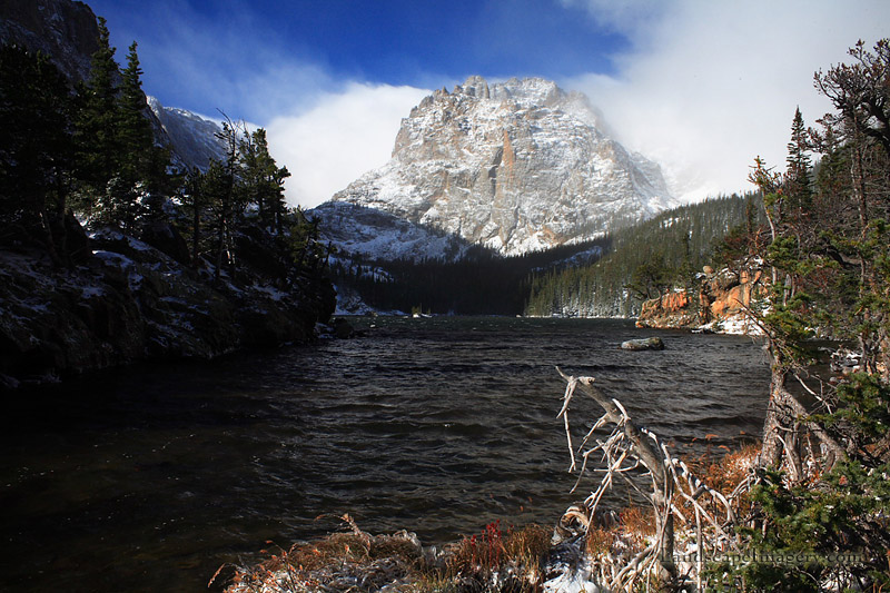
Crews will repair and upgrade an aging dam at a popular lake in Rocky Mountain National Park next year.
The National Park Service said Tuesday the work at Sprague Lake Dam will be done in the fall of 2017, and parts of the trail around the lake will be closed.
The half-mile trail is wheelchair-accessible and affords sweeping mountain views. The lake is popular with anglers and picnickers and is open year-round.
Repair work will include improvements to the spillway, raising the dam slightly in some areas and reinforcing the lake side of the dam to prevent erosion.
The park had 4.1 million visitors last year and is on pace to exceed that this year. The park does not track visitor numbers to Sprague Lake.
The orange plume flows through the Animas across the Colorado/New Mexico state line the afternoon of Aug. 7, 2015. (Photo by Melissa May, San Juan Soil and Conservation District)
Local, state and tribal officials gathered at the Sycamore Park Community Center gym in Farmington today for a roundtable discussion aimed at prompting the U.S. Environmental Protection Agency to address lingering concerns from the Gold King Mine spill.
The meeting was convened by U.S. Rep. Ben Ray Luján, D-N.M., who billed it as an opportunity to combine voices and “hold the EPA accountable for damages.” Topping the list of grievances for most parties was the struggle to secure compensation for response efforts and losses in the wake of the spill.
“To this day, many farmers haven’t been reimbursed,” Navajo Nation President Russell Begaye said. “That’s been an ongoing battle.”
[…]
Farmington officials also noted that the city has not received full compensation for the $516,000 it spent on spill response measures, including the purchase of a $260,000-sensor system to protect the city’s drinking water supply from lingering contamination in the Animas River. Mayor Tommy Roberts said the city has received $110,000 so far.
Alexis Strauss, acting director of the EPA’s Region 9 office, represented the agency via a video feed. She said the EPA has allocated $3 million to states and tribes for emergency response costs. She said additional claims are currently under review and handled by the U.S. Justice Department rather than the EPA’s regional offices.
“Those decisions are imminent and will be announced very soon,” Strauss said.
According to a retrospective report compiled by the agency for the one-year anniversary of the spill, the EPA has dedicated a total of $29 million toward response measures. Costs include $7.3 million for sampling and analysis, and $5 million for agency personnel. The report states that the EPA is currently in the process of awarding $2 million in grant money to states and tribes for water quality monitoring.
Funding such programs has become a divisive subject between the state and the federal agency. The New Mexico Environment Department has criticized the scope of the EPA’s long-term monitoring plan, pushing for funding to develop its own.
Bruce Yurdin of the NMED’s Surface Water Quality Bureau told officials at the meeting that the department has only received 10 percent of what it considers necessary to study the impact of contaminants released during the spill.
Such disparities prompted the recent lawsuits filed by New Mexico against the EPA, the state of Colorado and several mining companies. Begaye said today that he supports the string of legal actions, and the Navajo Nation is considering filing litigation of its own.
In addition to the issue of restitution, the discussion also delved into methods to address future incidents.
“There’s a large possibility that this could happen again,” San Juan County Executive Officer Kim Carpenter said…
As the meeting drew to a close, Rep. Luján asked officials to compile a list of their concerns for submission to EPA Administrator Gina McCarthy. He said the spill has captured the attention of congress, and efforts to fund response programs have drawn bipartisan backing.
On April 7, 2016, the Environmental Protection Agency proposed adding the “Bonita Peak Mining District” to the National Priorities List, making it eligible for Superfund. Forty-eight mine portals and tailings piles are “under consideration” to be included. The Gold King Mine will almost certainly be on the final list, as will the nearby American Tunnel. The Mayflower Mill #4 tailings repository, just outside Silverton, is another likely candidate, given that it appears to be leaching large quantities of metals into the Animas River. What Superfund will entail for the area beyond that, and when the actual cleanup will begin, remains unclear. Eric Baker
Faced with three different financing mechanisms for Longmont’s $47 million portion of the Windy Gap Firming Project, the council chose to gather more information from the public first.
Longmont public works and natural resources staff told the council on Tuesday that they have three options to finance the $47 million — completely through rate increases, through rate increases and by issuing $6 million in debt or by issuing $16.7 million in debt.
The decision directly affects Longmont residents’ wallets. Essentially, paying cash up front with rate increases means steep rate jumps in the next two years but is cheaper in the long term.
If the council chooses eventually to finance it completely through cash, water rates will need to jump 21 percent in 2017 and 22 percent in 2018, including 9 percent increases already approved.
Debt, on the other hand, would cause milder rate increases for more years, and cost the city more long term.
On the other end of the extreme, council could choose to ask the voters to issue $16.7 million in debt for the project, which would mean delaying adding an additional increase to rates until 2018. In 2018, they would need to be raised 14 percent and another 14 percent in 2019, then between 5 and 7 percent each in years between 2020 through 2026.
With a projected 4.25 interest rate, a $16.7 million bond would cost an additional $8.4 million in interest, for a total of $25.1 million over 20 years.
In the middle of the two extremes is an option of a mix of cash and debt. The City Council could vote to issue up to $6 million in debt to finance Windy Gap without a vote of the general public. This would cause water rates to jump 17 percent each in 2017 and 2018, by zero percent in 2019 and between 4 and 7 percent each in years between 2020 to 2027.
Dale Rademacher, general manager of public works and natural resources, told the council that staff has timed it out so that the city wouldn’t lose any of the options by commissioning a survey of residents on the Windy Gap financing issue…
The council opted to commission a statistically valid survey be sent to 3,000 randomly chosen Longmont households explaining the three options.
Colorado-Big Thompson Project east slope facilities
Here’s the release from Larimer County (Kerri Rollins):
Larimer County Department of Natural Resources purchased a 211-acre farm southwest of Berthoud, along with its valuable water rights. The deal closed Monday, August 8.
Using Help Preserve Open Spaces sales and use tax dollars, Larimer County Department of Natural Resources purchased the property, known previously as the Malchow Farm, to conserve its agricultural, historic, scenic, community buffer and educational values. General public access is not permitted at this time. Larimer County plans to continue leasing the property as an active agricultural farming operation.
The Town of Berthoud provided $100,000 to Larimer County to help purchase the farm, which will also help leverage a potential Great Outdoors Colorado funding request being submitted later this month.
“We’re excited to acquire this farm and its myriad of conservation values,” said Gary Buffington, director of Larimer County Department of Natural Resources. “The property helps us further our mission to conserve working lands and foster an appreciation for our agricultural heritage in Larimer County.”
This property is located one mile southwest of Berthoud, just north of the Little Thompson River and adjacent to U.S. 287 on the highway’s west side. It consists of high-quality agricultural soils, with approximately 188 irrigated, 18 pasture and 5 farmstead acres. Located just north of the Larimer-Boulder county line, the property serves as a gateway to Larimer County and a doorstep to the town of Berthoud, with sweeping views of Longs Peak and the Front Range. The property contains several historic features, including a pioneer gravesite, beet shack and a big red barn that can be seen for miles. The Overland Trail once crossed the property.
The property, infrastructure and minerals were purchased along with the valuable water rights, including 240 units of Colorado-Big Thompson, or C-BT, water, 16 shares of Handy Ditch native water rights and 20 shares in Dry Creek Lateral Ditch.
Larimer County is actively seeking partners to engage in a water sharing agreement on this property that will provide partnership funds toward the purchase of the water, keep the farm in active production and allow water partners to share some of the water in drought years. This water sharing agreement, known as an Alternative Transfer Mechanism, or ATM, is a cooperative solution encouraged by the Colorado Water Plan to share water across uses without permanently drying up high-quality working farms, such as this farm near Berthoud.
Larimer County has developed a stewardship plan for the property and will develop a full management plan with public input within the next several years. The property was purchased from the Malchow family, but an official name for the property, now that it’s a Larimer County open space, will be chosen at a later date. Public tours of the property are planned for later this year.
For additional information, contact Kerri Rollins, Open Lands Program manager, at (970) 619-4577.
Larimer County now officially owns the 211-acre Malchow farm south of Berthoud and its associated water rights — a unique agreement that includes a water sharing component.
The $8.4 million sale from the Malchow family to the Department of Natural Resources closed Monday.
The county bought the property to conserve its agricultural, historic and scenic values and plans to continue leasing the fields as an active farm.
One unique aspect of the sale was that the county also bought the water rights, including 240 units of Colorado-Big Thompson water, with the intention of entering into a water sharing agreement.
Under such an agreement, the farm may vary its crops over several years, so in drought years, some of the irrigation water can be sold.
This allows the farm to stay in production for the long-term and is an arrangement encouraged by the Colorado Water Plan.
The farm is located along U.S. 287 one mile southwest of Berthoud, and along with rich farmland, it includes historic buildings and a pioneer grave site believed to be tied to the Overland Trail, which once crossed the property…
The farm will not immediately be open for public access. However, a management plan that will be developed within the next few years could include an educational component in which the farm may be used to teach the public about agriculture.
The town of Berthoud pitched in $100,000 toward the purchase of the property, and Larimer County will be applying for a Great Outdoors Colorado grant to help with the cost.
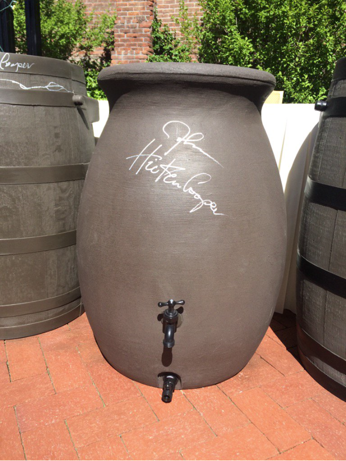
On Thursday May 12, Western Resource Advocates joined others to celebrate HB16-1005, legalizing the use of rain barrels, becoming law.
Governor Hickenlooper signed a rain barrel at the HB16-1005 bill signing ceremony. Photo via @jessica_goad and Twitter.
Recently passed legislation in Colorado allows for small scale residential collection of rain from rooftops into barrels like the one pictured here. Photo: Roger Mommaerts, Flickr Creative Commons
Photo credit: Photo credit: Krzysztof Lis, Creative Commons, Flickr. Via the Colorado Independent.
Gov. John Hickenlooper signed House Bill 1005 in May, and now it’s up to residents to buy and install rain barrels, as long as limitations are followed.
Most single-family homes and townhomes can use rain barrels to collect water, but homeowners can’t have more than two 55-gallon barrels.
Those who live in residences with homeowners associations shouldn’t buy and install rain barrels right away, though. Like the American flag, an HOA can’t ban the barrels, but it can implement requirements about how they’re used, since the barrels fall under an exterior change. Abby Bearden, office manager and architecture review committee manager for Greeley Community Management, LLC, said rain barrels should be approved prior to installment, that way there are no issues or unforeseen problems.
Once approval is given, rain barrels can be purchased in a number of hardware stores or online. Installation is relatively simple, but TreePeople, a Los Angeles company that disseminates information about rain barrels, said the water catching devices should be installed on a raised surface, attached to a gutter. A downspout will be needed to get downpour directly into the barrel. It’s also important to make sure the barrel is secure, in case of harsh weather.
Once the barrels start collecting rain, the water can’t be used for just anything. The new law allows for outside use on the owner’s property, so watering lawns and plants outside is OK, but greenhouses and indoor uses are not allowed.
Reagan Waskom, director of the Colorado Water Institute, said the barrels should be cleared about once a week during the summer, and should be disconnected during the winter.
It shouldn’t take too many storms before there is plenty of water gathered to use on lawns and gardens, Waskom said.
Waskom said he doesn’t anticipate too many people running out and buying rain barrels, but he said in other states, about 10 percent of the population actually uses them. That figure shouldn’t be enough to hurt water right owners, which is a big reason why the controversial legalization of rain barrels was finally approved.
The way Colorado’s water law works is similar to a first-come, first-serve model. It’s called prior appropriation. The first person to take and use the water for an agricultural, industrial or household reason got the first rights to that water. These are called senior water rights. Those who secured water rights later can use what was remaining after the senior water user took what they were allotted. These are called junior water rights.
There was concern that rain barrels can prevent runoff into the water sources people have rights to, which would hurt the non-senior holders first, but Colorado State University conducted a study that showed rain barrels shouldn’t hurt the water supply.
Not everyone was convinced, like Sen. Jerry Sonnenberg, R-Sterling. He said the bill didn’t do enough to guarantee rain barrel users would be responsible in case their use of rain barrels does hurt in senior water rights holders. He was one of three legislators to vote against the bill.
There is a provision in case there is a loss of water due to rain barrels, though. It was written into the bill that there can be a reexamination of regulation if there wasn’t enough runoff water getting to water sources.
“If everyone were to (buy barrels) there are the checks and balances in there so somebody can go back there and look on a regular basis to see if there is, indeed, an impact,” said Northern Water’s Brain Werner in May.
A new long-term plan by the South Metro Water Supply Authority, which serves 13 water providers in the greater Denver-Aurora area, avoids any mention of taking water from the Arkansas River basin.
That’s significant, because the group’s 2007 master plan included two possible pipeline routes from the Arkansas River basin as a way of filling future water supply needs. Located in some of the fastest-growing areas of Colorado, South Metro’s population increased to 325,000 in 2016 from 250,000 in 2005.
South Metro communities were built on water from the Denver Basin aquifer, but began shifting their focus to finding new renewable supplies, conservation and increasing efficiency as ways to stretch their supplies.
“I think our members wanted to focus on projects that are on a foreseeable timetable,” said Eric Hecox, executive director of the authority. “The study confirms our region’s tremendous progress toward securing a sustainable water future. There is more to be done, but there is no question we are on the right path.”
With Pure Cycle’s sale of its Fort Lyon Canal water rights last year, no South Metro member has any projects planned in the Arkansas Valley. Pure Cycle is connected to the emerging Rangeview district east of Aurora.
Annual demand for South Metro is expected to more than double to 120,000 acre-feet (39 billion gallons) by 2065. Increased storage, expanded use of the WISE agreement with Denver and Aurora and continuing conservation efforts are expected to fill 38,400 acre-feet in the next 50 years.
The WISE agreement allows South Metro areas to reuse return flows from the Denver area through Aurora’s Prairie Waters Project. Reuter-Hess Reservoir and the East Cherry Creek Valley pipeline have opened new ways to use water. Per capita use in the South Metro area has decreased 30 percent since 2000.
Another 30,000 acre-feet annually of new supplies still are needed by 2065, according to the revised master plan released Tuesday. About two-thirds of that supply is identified in existing projects, but the plan proposes finding the remainder through cooperative agreements with other users in the South Platte and through the Colorado River Cooperative Agreement, Hecox said.
Finally, individual members of the South Metro group are developing innovative solutions. For instance, Sterling Ranch is harvesting rainwater and incorporating conservation into land-use design. Other communities have initiated landscape regulations and some are even paying property owners to remove turf or plants that use excessive amounts of water. Some rate structures have been changed to promote conservation.
The new plan fits in with Colorado’s Water Plan, which seeks collaborative solutions rather than buying agricultural water rights and drying up farmland.
“A remarkable transformation is happening in the South Metro region,” said James Eklund, executive director of the Colorado Water Conservation board. “Colorado’s Water Plan calls for innovative water management and this study demonstrates how this important region is transitioning to a more sustainable water supply.”
Here’s the release from the South Metro Water Supply Authority:
SMWSA Master Plan shows tremendous progress transitioning to renewable water
South Metro region now a state leader in conservation, efficiency and reuse
Hecox: ‘More to be done, but there is no question we are on the right path’
The South Denver Metro region has made tremendous progress securing a sustainable water future over the past 12 years thanks to aggressive efforts to conserve water, maximize efficiency and invest in renewable water supplies, according to the results of the 2016 South Metro Water Supply Authority (SMWSA) Master Plan Update.
“A remarkable transformation is happening in the South Metro region,” said James Eklund, director of the state’s water agency and architect of Colorado’s Water Plan. “Colorado’s Water Plan calls for innovative water management and this study demonstrates how this important region is transitioning to a more sustainable water supply.”
South Metro Water Supply Authority boundaries
The report, produced by SMWSA and its technical consultant, CH2M, is the most definitive study of water demand and supplies of the region in nearly a decade.
“The study confirms our region’s tremendous progress toward securing a sustainable water future,” said Eric Hecox, executive director of SMWSA. “There is more to be done, but there is no question we are on the right path.”
Historically many communities in the region relied on nonrenewable groundwater from the Denver Basin Aquifer system for much of their water supply. For some, it was their only water supply as recently as 12 years ago. The significant decline in groundwater levels was unsustainable and threatened to undermine the region’s economic vitality and overall quality of life.
Recognizing the challenge, water providers joined forces in 2004 to create SMWSA and develop a plan. The result of that work to date is outlined in the Master Plan update:
Transition to renewable water: In 2004, less than half of the region’s water supply came from renewable sources. By 2020, more than three-fourths (78 percent) of the region’s water supply will come from renewable water supplies, according to the study. This marks a significant transformation of the region’s water supply. By 2065, a full 85 percent of the region’s supplies will come from renewable sources, according to the study. Notably, this progress is being made despite a projected 130 percent increase in total water demand over the same period.
Investment in renewable water projects: This transition to renewable water is the result of a number of regional projects that communities throughout the region have invested in, including WISE, the Chatfield Reallocation Project, Reuter Hess Reservoir, the ACCWA/ECCV Northern Project, Castle Rock’s Plum Creek Water Purification Facility and many more.
Leading in conservation: The South Metro region has established itself as a leader in conservation and water stewardship with some of the strongest and most effective conservation efforts of any region in the state. Per capita water demand in the region decreased by 30 percent since 2000. The region now boasts among the lowest consumption rates in the state.
Maximizing efficiency: SMWSA and its members are maximizing water efficiency by reusing water to the fullest extent possible. “This is tremendous progress given the immense water challenges the region faced just 12 years ago,” said Mike Fitzgerald, president and CEO of the Denver South Economic Development Partnership. “We are on a path to a secure and sustainable water supply, which is critical to maintaining our region’s excellent quality of life and economic vitality for future generations.”
More Work Ahead
While the region is on track to meet projected demand as far out as 2065, more work is needed to ensure that happens, Hecox said.
Future possible projects and plans include adding new supply and storage, groundwater management, conservation and efficiency.
“We must execute on current plans, continue our conservation efforts, build our renewable supplies and maximize what we have through reuse,” Hecox said. “If we continue the course, we will deliver on our promise of a secure water future for the region.”
The Durango Herald has been all over this story for a year now. Click here for their roundup of articles.
This image was taken during the peak outflow from the Gold King Mine spill at 10:57 a.m. Aug. 5. The waste-rock dump can be seen eroding on the right. Federal investigators placed blame for the blowout squarely on engineering errors made by the Environmental Protection Agency’s-contracted company in a 132-page report released Thursday [October 22, 2015]A “get well soon” balloon floats in the contaminated waters of the Animas River flowing through Durango on Monday afternoon August 10, 2015 — photo The Durango Herald, Shane BenjaminOn April 7, 2016, the Environmental Protection Agency proposed adding the “Bonita Peak Mining District” to the National Priorities List, making it eligible for Superfund. Forty-eight mine portals and tailings piles are “under consideration” to be included. The Gold King Mine will almost certainly be on the final list, as will the nearby American Tunnel. The Mayflower Mill #4 tailings repository, just outside Silverton, is another likely candidate, given that it appears to be leaching large quantities of metals into the Animas River. What Superfund will entail for the area beyond that, and when the actual cleanup will begin, remains unclear. Eric Baker
Click here for all the inside skinny. From the Colorado River District website:
The Colorado River District’s popular one-day Annual Water Seminar is scheduled for Friday, Sept. 16, 2016 from 9:00 am to 3:30 pm at Two Rivers Convention Center, 159 Main Street, Grand Junction, Colo..
The theme is: “Colorado River Waves of the Future: Fitting the West to the River’s New Normal.” Cost, which includes lunch, is $30 if pre-registered by Friday, Sept. 9; $40 at the door. For information, contact Meredith Spyker. at 970-945-8522; seminar registration form 2016
Speakers will address the Lower Basin living within its water means and dealing with its “structural deficit,” how the Upper Basin is planning to deal with low levels at Lake Powell, sorting through the confusing programs addressing ag fallowing, a discussion of Use It or Lose It myths and a panel addressing what comes next after the Colorado Water Plan, especially with declining financial resources — plus more.
Draft agenda:
Temperatures Matter: Brad Udall, Colorado Water Institute, Colorado State University
How the Lower Basin is Attacking the Structural Deficit: Speaker invited
How the Upper Basin is Attacking Low Water Levels at Lake Powell: Eric Kuhn, Colorado River District
Sorting through the Demand Management Weapons: Water Banking/System Conservation – who’s doing what: Dave Kanzer, Colorado River District
Lunch Program
Use it Or Lose It – Separating Truth, Myth and Reality: Justice Greg Hobbs
Colorado’s Water Plan – What now? Panel Discussion with Colorado Water Conservation Board’s James Eklund; Colorado Legislature Rep. Don Coram, Anne Castle, Getches-Wilkinson Center for Natural Resources, Energy, and the Environment
The latest change to plans for NISP would be potentially moving the location for Galeton Reservoir about two miles to the north and a little bit west of its previously planned site northeast of Greeley, according to Fort Morgan Water Resources/Utilities Director Brent Nation.
This would be due to all the oil wells that have sprung up recently on the site originally planned by Northern Water for Galeton, which would be the part of NISP that held Fort Morgan’s 9 percent stake in the overall water storage project.
“We as participants have been well aware of the possibility of needing to move the Galeton Reservoir site,” Nation said. “That’s been in all of the applications, it’s been in all of the engineering work. The original site that was selected for that is now, basically, it looks like a large oil field. There’s well sites all over it.”
But Northern Water (aka Northern Colorado Water Conservancy District) has found another possible site for Galeton, and it’s not very far from the original plan, making much of the work done on studying and understanding the proposed location still useful, Nation said.
“As they were drilling more and more, it became obvious that they needed to maybe look into an alternative site,” he said. “And so they’re literally identifying a piece of ground that’s two miles further north. It’s in the same draw, it’s got the same formation. None of the characteristics really change, other than a little bit of pipeline length to get the water there and (some pumping to) get the water out.”
“We have found a site in the same vicinity as Galeton and believe it makes sense to make this move,” stated Carl Brouwer, project management manager from Northern Water.
Northern Water is doing more studies on the proposed new location for Galeton, but the district’s officials do not expect any problems with that site, according to information Nation provided to the Fort Morgan Times from both Brouwer and Northern Water General Manager Eric Wilkinson.
“We are doing ‘due diligence’ on Galeton North and have contacted parties that own land within the Galeton North Reservoir basin,” stated Wilkinson. “We have not found a fatal flaw associated with Galeton North. … The site will require two miles of additional pipeline, as it is further north, and (a) small amount of additional pumping. However, these additional costs appear to be more than offset by the additional costs associated with plugging and re-drilling the oil wells within the existing Galeton Reservoir footprint.”
A view of the Maroon Bells from just below the confluence of East Maroon and West Maroon creeks, where the city of Aspen has told the state of Colorado it intends – at some point – to build a 155-foot-tall dam. The resulting reservoir would back up 4,567 acre-feet of water and cover 80 acres of USFS land, including a portion of the Maroon Bells-Snowmass Wilderness.
ASPEN – After holding both private and public meetings last week about its conditional water rights for dams and reservoirs on upper Maroon and Castle creeks, the city of Aspen is likely facing opposition in water court if it files a request to extend the water rights for another six years.
“If their diligence filing is consistent with the current project configuration, I do think we will file a statement of opposition,” said Matt Rice, Colorado basin director for American Rivers, a national river conservation organization.
The city has until the end of October to file a due diligence report in Division 5 water court in Glenwood Springs. Such filings are required every six years.
In its September 2009 diligence filing, which was approved in 2010, the city told the water court “it has steadily applied efforts to complete” the dams and reservoirs “in a reasonably expedient and efficient manner.” The city first filed for the conditional water right in 1965 and the conditional rights were formally decreed in 1971.
The view, with a zoom lens, of the Bells from the meadow that would be flooded by a Maroon Creek Reservoir. The meadow is known as the Stein Meadow and the wedding meadow.
Routine filing?
At a public meeting Thursday a consultant working for the city, Larissa Reed of Common Ground Environmental Consulting LLC, told the gathering of about 35 people that the city’s pending due diligence filing was “routine.”
“City council is not proposing to build water storage reservoirs at this time,” Reed said. “What they are doing is thinking about the conditional water storage rights and whether or not they should be filed for again in October for another six years.“
A work session with city council on the question is to be held in September or October.
Reed then explained some aspects of conditional water rights, including the “can and will” test for proposed water supply projects.
“The phrase ‘can and will’ suggests, in the law, that you have to be making progress towards developing this water supply in order to re-up every six years in your diligence filing,” Reed said. “The idea is that applicants have to show that they are making progress on those water rights, that they’re not just sitting on them doing nothing.”
A view looking down the Castle Creek valley at one of the many wetlands that would be covered by the potential Castle Creek Reservoir. The city of Aspen has told the state it intends to build – at some point – a 170-foot-tall dam that would stretch about 1,000 feet across the Castle Creek valley and back up 9,062 acre-feet of water, inundating 112 acres of public and private land.
Can and will?
Since 1965, the city has consistently told the state it intends – at some point – to build a 155-foot-tall dam at the confluence of East and West Maroon creeks that would store 4,567 acre-feet of water behind it and build a 170-foot-tall dam on Castle Creek that would back-up 9,062 acre-feet of water.
The city has not undertaken feasibility or cost studies of the dams and reservoirs since filing for the water rights, although the Bureau of Reclamation did conduct limited test drilling on the Castle Creek dam site in 1970.
Nor has the city determined how much water storage it actually might need in the future, or what other storage locations might be feasible, according to David Hornbacher, the city’s director of utilities and environmental initiatives.
Castle Creek, not far below Ashcroft. This section of water would be covered by a potential Castle Creek Reservoir.
Facilitated sessions
On Wednesday, the city held a private stakeholders meeting about the conditional water rights with representatives from American Rivers, Wilderness Workshop, Roaring Fork Conservancy, Aspen Center for Environmental Studies, the Colorado River District, U.S. Forest Service, and Colorado Parks and Wildlife.
The formats of both the private stakeholders meeting and Thursday’s public meetings were the same, with remarks from the consultant and Hornbacher, limited time for questions, and then facilitated small-group discussions focused on questions crafted by the city.
“I’m hopeful that they will take this public input and present it to the council in an unbiased and accurate fashion,” said Rice of American Rivers, who attended Wednesday’s stakeholder meeting, “but if the city moves forward with due diligence for a reservoir on Maroon Creek and a reservoir on Castle Creek, we intend to stand up for those rivers and those wild places and oppose.”
When asked if American Rivers was prepared to take its opposition to a level of active litigation in water court, which typically comes after a lengthy period of time when parties are asked by the court to work out their differences in private meetings, Rice said he hoped it wouldn’t go that far.
“I would hope that it would give the city an opportunity to investigate real alternatives to this project to meet their future water supply needs,” he said of discussions during the initial phase of the process. “One thing that a statement of opposition in a diligence filing does is that inspires those discussions at a quicker pace than would happen otherwise.”
American Rivers filed a statement of opposition in response to a diligence filing in 2011 from the Colorado River Water Conservation District and the West Divide Water Conservancy District for conditional water rights for two large dams on the Crystal River.
The River District and the West Divide District agreed to abandon those water rights in 2013.
Pitkin County also filed a statement of opposition against the Crystal River conditional water rights and took an active role in the proceedings.
After Thursday’s public meeting on the rights on Maroon and Castle creeks, Laura Makar, an assistant county attorney for Pitkin County, said the county had not yet decided if it would oppose a diligence filing by the city.
“We don’t have a position at this point in time,” Makar said. “The diligence filing is not due until October. Any statement of opposition would not be due until December. We’re in August right now, so I anticipate we’ll have a position at some point.”
In a small bit of irony, there is a 2-foot-tall beaver dam just below the location where Aspen has told the state it intends to build a 155-foot-tall dam – someday.
Dueling statements
Pitkin County Commissioner Rachel Richards, a former mayor of Aspen, attended Thursday’s meeting. She said during the small-group discussions that she thought it was “premature” for the city to abandon its conditional rights for the dams and reservoirs.
Will Roush, a conservation advocate for Wilderness Workshop, attended both the private stakeholders meeting and the public meeting.
When asked Friday if Wilderness Workshop intended to oppose the diligence filing, Roush said, “We’ll make that decision once they decide whether or not to file a diligence filing,” but also said his organization wants Aspen to abandon the water rights.
Paul Noto, a water attorney at Patrick, Miller, Noto who fought the city’s proposed hydropower plant on lower Castle Creek on behalf of a group of local clients, was asked if he expected someone to file a statement of opposition if the city filed.
“It’s not a question of someone, it is a question of how many,” Noto said. “There is going to be a lot of opposition to this project. The reason is Aspenites, and others, hold Castle and Maroon creek valleys near and dear to their hearts and I think a lot of people passionately believe, rightly so, that there shouldn’t be dams in those valleys.”
Rob Harris, the senior staff attorney at Western Resource Advocates of Boulder, also was at Thursday’s meeting. Afterward, he was critical of the city’s dueling messages about its intentions for the dams and reservoirs.
“The city can’t and shouldn’t say different things to the public that it says to the water court,” Harris said. “The city shouldn’t come in here, to this public meeting, and say, ‘We don’t really have any plans to build these dams’ and then go into the water court and say, ‘We can and will build these reservoirs.’ Those are two different, inconsistent, statements.”
He also challenged the way the city made it sound that climate change made the dams necessary.
Ashley Perl, the director of the city’s Canary Initiative, had presented climate projections at the meeting that showed less water would likely be in Aspen-area rivers in a hotter future. She said that Aspen doesn’t have any water storage facilities, which made it vulnerable, and that the community needed to have a conversation about storage.
But Harris said, “It is important to note that nothing we saw tonight connected any of those water availability scenarios under those climate models to actual water needs that the city of Aspen has. There was nothing presented tonight that showed that in any of those scenarios that Aspen would in fact be short of water.”
Harris added, “If the city does identify a water need, they have lots of other alternatives” than the dams and reservoirs.
The city has set up an email address for citizens to send comments and questions about the conditional water rights, at waterrights@cityofaspen.com, until Aug. 19.
One of the many wetlands in the area that would be covered by a Castle Creek Reservoir.
Regional reservoirs and dams, ranked by normal storage capacity
During a public meeting on Aug. 4, 2016, the city of Aspen presented a graphic comparing the surface area of various regional reservoirs with the surface area of the proposed Castle and Maroon creek reservoirs.
We’ve expanded the list, added more criteria, ranked it by storage capacity, and used data from the Colorado Dept. of Dam Safety, including their term of “normal storage” for the storage capacity amount.
For Castle and Maroon, which the city labeled in their presentation as “proposed,” we’ve simply used “storage capacity.”
AF means “acre feet.” There are 325,851 gallons of water in an acre-foot.
Ruedi Reservoir
Normal storage: 102,369 AF
Dam height: 291 feet
Dam length: 1,060 feet
Surface area: 998 acres
Homestake Reservoir
Normal storage: 42,900 AF
Dam height: 231 feet
Dam length: 1,996 feet
Surface area: 333 acres
Paonia Reservoir
Normal storage: 20,950 AF
Dam height: 199 feet
Dam length: 770 feet
Surface area: 334 acres
Rifle Gap Reservoir
Normal storage: 13,602 AF
Dam height: 124 feet
Dam length: 1,450 feet
Surface area: 359 acres
Proposed Castle Creek Reservoir
Storage capacity: 9,062 AF
Dam height: 170 feet
Dam length: Approx. 1,000 feet
Surface area: 112 acres
Proposed Maroon Creek Reservoir
Storage capacity: 4,567 AF
Dam height: 155 feet
Dam length: Approx. 1,500 feet
Surface area: 80 acres
Spring Park Reservoir
Normal storage: 1,732 AF
Dam height: 20 feet
Dam length: 1,645 feet
Surface area: 258 acres
Wildcat Reservoir
Normal storage: 1,100 AF
Dam height: 75 feet
Dam length: 1,100 feet
Surface area: 50 acres
Ivanhoe Reservoir
Normal storage: 752 AF
Dam height: 16 feet
Dam length: 270 feet
Surface area: 82 acres
Grizzly Reservoir
Normal storage: 590 AF
Dam height: 56 feet
Dam length: 792 feet
Surface area: 44 acres
Dinkle Lake
Normal storage: 460 AF
Dam height: 40 feet
Dam length: 580 feet
Surface area: 20 acres
Ziegler Reservoir
Normal storage: 248 AF
Dam height: 28 feet
Dam length: 500 feet
Surface area: 16 acres
Chapman Reservoir
Normal storage: 100 acre feet
Dam height: 37 feet
Dam length: 160 feet
Surface area: 10 acres
Editor’s note: Aspen Journalism, the Aspen Daily News, and Coyote Gulch are collaborating on coverage of rivers and water. The Daily News published this story on Monday, August 8, 2016.
A highlights-only Monthly “Micro-Briefing” was posted today on the Intermountain West Climate Dashboard. These highlights, also provided below, cover July’s precipitation and temperatures, drought conditions, April-July Lake Powell inflows, and ENSO outlook.
Highlights:
July was another hotter-than-normal and drier-than-normal month for the region, though not quite as hot or dry as June. Most the region saw less than 70% of normal precipitation, while several areas had much-above-normal precipitation. Northern Utah and southern Wyoming were the driest parts of the region.
Drought conditions have expanded in Wyoming and Utah, with abnormally dry (D0) or worse conditions now covering more than 55% of both states. The 2-week and 4-week EDDI maps indicate that during July, the atmosphere was unusually thirsty over most of Wyoming and nearly all of Utah, pointing to the potential for more further drought onset and intensification.
Observed inflows to Lake Powell for April through July ended up at about 6630 KAF (93% of average and 102% of median), the third year in a row with inflows of 90-100% of average, following the the extreme drought years of 2012 and 2013.
According to ENSO model forecasts , a transition from the current ENSO-neutral to La Niña conditions during the coming fall and winter is still favored, but the likelihood has slipped since last month, to about 60%.
Releases from Crystal Dam will be decreased from 2000 cfs to 1800 cfs on Wednesday, August 10th. July inflows to Blue Mesa Reservoir ended up being less than predicted and August inflow forecasts are also declining. The April-July runoff volume finished the season at 89% of average. The current content of Blue Mesa Reservoir is 757,000 acre-feet which is 91% full.
Flows in the lower Gunnison River are currently above the baseflow target of 1050 cfs. Flows are expected to remain above the baseflow target for the foreseeable future.
Pursuant to the Aspinall Unit Operations Record of Decision (ROD), the baseflow target in the lower Gunnison River, as measured at the Whitewater gage, is 1050 cfs for August through December.
Currently, diversions into the Gunnison Tunnel are around 1000 cfs and flows in the Gunnison River through the Black Canyon are around 1000 cfs. After this release change Gunnison Tunnel diversions will still be at 1000 cfs and flows in the Gunnison River through the Black Canyon should be around 800 cfs. Current flow information is obtained from provisional data that may undergo revision subsequent to review.
Macro Invertebrates via Little Pend Oreille Wildlife Refuge Water Quality Research
Click here to read the newsletter. Here’s an excerpt:
We had a wonderful time with Beaver Creek Summer Day Camp, bug sampling on Gore Creek and learning about different types of macroinvertebrates. Stoneflies and mayflies galore! Looking for a fun, engaging, and educational way to get kids on the river during the summer? Email schoder@erwc.org for inquiries!
July’s reputation for sizzle didn’t disappoint, bringing record warm temperatures to Florida and New Mexico and much above-average temperatures across the South, the East Coast and Alaska.
The average July temperature for the contiguous U.S. was 75.3 degrees F, making it the 14th warmest July on record, according to scientists from NOAA’s National Centers for Environmental Information. July precipitation averaged 2.87 inches (0.40 inch above average).
From January through July, the average temperature for the Lower 48 states ranked as the third warmest on record at 54.3 degrees F, 3.0 degrees above average. Thirty-eight states were much warmer than average.
Other notable climate events for July included:
Alaska: Alaska had its 4th warmest July and set a new record for the warmest year to date, with an average statewide temperature of 33.9 degrees F, 8.1 degrees above average.
New Mexico: New Mexico set a new heat record with an average temperature of 76.8 degrees F, 4.1 degrees above average. This also tied July 2003 as the warmest month of any month on record.
Florida: Florida was record warm for the month, reaching an average temperature of 84.0 degree F, 3.0 degrees above average. This was the second warmest month of any month on record.
Kentucky: Parts of western Kentucky received record rainfall totaling more than 16 inches and causing widespread flooding.
Hawaii: On July 24, Tropical Storm Darby made landfall on Hawaii’s Big Island with sustained winds of 40 mph and heavy rains in excess of 10 inches.
U.S. drought: By month’s end, 21.1 percent of the contiguous U.S. was in drought, up about 4.9 percent since end of June.
More: Find NOAA’s reports and download images by visiting the NCEI website.
Click here to read the newsletter. Here’s an excerpt:
What you missed at the CWCB July Board meeting in Steamboat Springs…
Our newest Board member, Jim Yahn, was sworn in to represent the South Platte River Basin. Jim is the manager of the North Sterling and Prewitt Reservoirs where he oversees the diversion and distribution of water to over 350 farmers.
Carlee Brown attended her first Board meeting as the new Section Chief for the Interstate, Federal, and Water Information Section. Previously, Carlee was the Policy Advisor for water at the Western Governors’ Association (WGA), where she led WGA’s bipartisan efforts on drought, the Clean Water Act, water data, and groundwater.
The implementation of Colorado’s Water Plan is in full swing. Some highlights:
Distributed over $5M in WSRF funds from statewide and basin accounts since the beginning of November 2015. This $5m has been successfully leveraged against over $25M in matching contributions.
CWCB staff are working with other stakeholders to provide water loss trainings statewide over the next few years. These trainings will update water managers on proper water loss reporting and accounting.
A LEAN event was held between the Environmental Protection Agency (EPA), the Colorado Department of Natural Resources (DNR), the Colorado Water Conservation Board (CWCB), and local regulators, such as the Northwest Council of Governments (NWCOG) to improve the efficiency of the permitting process. Water providers and environmental groups were also involved. Stakeholders are creating a Permitting Handbook.
The CWCB Board and staff have developed a creative funding plan for up to five years, in its conception phase, that proposes:
$50 million one-time investment in a repayment guarantee fund
$10 million annually to the WSRF
$5 million annually to the Watershed Restoration Program
$10 million annually to non-reimbursable programs
The Non Native Fish Subcommittee is working to reduce non native fish populations through education, outreach, and harvest incentives. In the Ridgway Reservoir, the Smallmouth Bass adult population has been reduced by 36 percent.
Instream flow water rights have been decreed on Alkali Creek, Armstrong Creek, Brush Creek, East Douglas Creek, Schaefer Creek, Terror Creek, and Timber Springs Gulch, totaling 22 miles in length.
The Board approved a loan to the Southeastern Colorado Water Conservancy District for the Pueblo Dam Hydroelectric Project. This is the first phase of the Arkansas Valley Conduit project, which was a part of the original Fryingpan-Arkansas project signed by President Kennedy in 1962. The Board also approved a loan to the North Poudre Irrigation Company for rehabilitation of the Livermore Irrigation Tunnel. This project will help to ensure continued deliveries to more than 36 square miles of irrigated acreage.
The Board approved seven WSRF grants at this meeting, totaling $270,572.
The Longmont City Council on Tuesday will make several high-level decisions on how to finance the Windy Gap Firming Project.
In March, the council opted for the costlier 10,000 acre-foot level of the $387.36 million project, which would bring the pricetag for Longmont up to about $47 million. In April, the council directed they would prefer to pay with cash rather than debt for the $47 million, which would save money in the long-term but mean steep rate hikes in the short-term.
Now, staff has come back with a third option — a mix of cash and debt financing.
The council has already approved and codified raises to rates of 9 percent in both 2017 and 2018. If the council chose to finance the complete $47 million through rate increases, rates would need to rise 21 percent in 2017 and 22 percent in 2018, staff wrote to council in a memo.
But, raising rates is a little unpredictable for staff, because people might use less water in order to save money. While that helps with the city’s water conservation goals, it could make financing a huge project like Windy Gap tough.
“What we do know is that if we have a rate increase, it dampens consumption because people do react to an increased cost. What we’ve seen over time is that initial reaction tends to go away over time,” said Dale Rademacher, general manager of Longmont public resources and natural works…
By contrast, if Longmont chose to finance the $47 million project with $16.7 million in bonds, rates would not increase beyond the planned 9 percent in 2017 and then by 14 percent in 2018 and another 14 percent in 2019. The downside to debt is that it costs more in the long-term.
At a projected 4.25 percent interest rate, bonding out $16.7 million would cost the city $55.75 million over 20 years.
In the middle, staff has proposed bonding out only $6 million of the cost and financing the rest through rate increases.
This option would mean rate increases of 17 percent each in 2017 and 2018, between the two extremes of 21 percent with all cash and 9 percent with the higher debt option.
Rademacher said council could choose to bond out $6 million of the cost without a vote of the public…
Council on Tuesday needs to decide which financing option they want, and by extension, how much rates should raise in 2017.
Rademacher said all the rate raises are projected to happen by January 1, 2017 and if a major bonding issue needed to go to the ballot, staff are projecting to put it in front of voters in November, 2017.
Council could also decide to wait on the financing decision and get more public feedback on the issue. While there were questions related to Windy Gap on the regular Longmont resident survey, staff decided to remove those questions and ask council about a more specific survey.
National Research Center submitted a bid in order to survey Longmont residents about whether they would prefer to pay cash or debt for Windy Gap. To do an online-only survey would cost $3,440. To mail out a survey to randomly selected households would cost between $5,130 and $11,850 depending if NRC targeted 800, 1,500 or 3,000 households.
The reservoir that supplies 90 percent of the Las Vegas Valley’s drinking water bottomed out at 1,071.61 feet above sea level on July 1, its lowest level since May 1937, when the lake was filling for the first time behind a newly completed Hoover Dam.
Though the surface of the lake has ticked back up by about 2 feet since then, it remains 5 feet lower than it was at this time last year and 43 feet lower than it was in early August 2012.
But the news isn’t all bad.
The amount of water being drawn from the Colorado River for use in Nevada, Arizona and California is on track to hit its lowest level in more than 20 years, a sign that conservation efforts and temporary cuts by river users are having an effect, at least on the demand side of the ledger…
If the current federal projection holds, the three lower basin states will combine this year to consume less than 7 million acre-feet of Colorado River water for the first time since 1992…
That’s a “symbolically important milestone,” said author and long-time environmental journalist John Fleck, because the region’s population has grown by roughly 7 million people since the last time consumption was this low…
Even with reduced consumption, there will still be more water taken out of the river this year than there is flowing into it.
As a result, the record low set on July 1 is unlikely to stand for long. Federal forecasters expect Lake Mead to start 2017 about 6 feet higher than it is now, then dip downward again into record territory in April, before bottoming out next June or July at about 1,063 feet above sea level…
Though Lake Mead’s decline is expected to continue for the next two years at least, forecasters say the reservoir is likely to contain just enough water on Jan. 1, 2017, and Jan. 1, 2018, to avoid a first-ever federal shortage declaration that would trigger mandatory water reductions for Nevada and Arizona…
Mack said the voluntary cuts and conservation gains made already by cities, farms and water agencies in Nevada, Arizona and California are at least partially responsible for keeping Lake Mead just out of shortage territory. And more cooperative cuts are coming.
By the end of the year, officials in Nevada, Arizona and California hope to finalize a landmark deal outlining a series of voluntary water reductions designed to prop up Lake Mead and stave off deeper, mandatory cuts for Arizona and Nevada.
Arizona would shoulder most of the voluntary reductions, but the tentative deal marks the first time California has agreed to share the pain if the drought worsens.
As it stands now, California is not required to take any cuts to its 4.4 million acre-foot share of the Colorado, which is the largest annual allotment among the seven states that share the river.
If you’ve never rafted Gore Canyon it’s unlike any other river trip in Colorado. Gore is no float trip and should be run by experienced boaters if you are not going through a guide service. This adrenaline packed stretch of whitewater offers continuous class IV and V rapids. There are many outstanding guide services offered to run Gore Canyon, and it is well worth the money. The raft outfitters that run Gore use their top guides who know the canyon well and have the most experience on the water.
Gore is not for the faint of heart. It is recommended that anyone rafting this stretch be in good physical condition. Many companies that run Gore commercially have requirements that participants must meet in order to take the trip. As a guideline for fitness, it is recommended that you are able to run a mile and able to swim ten laps, as many companies suggest. You will most likely be required to swim a class III rapid that is encountered before entering into the IV’s and V’s. You will also have to practice pulling yourself back into the raft if you happen to find yourself on the “swim team,” and participate in a raft flip-drill so you will know what to do if the raft turns over, which is a strong possibility on a Gore trip.
Depending on water levels, Gore usually runs from mid August through the beginning of September which makes it perfect for those who were not able to raft mid summer. It is not recommended that Gore Canyon be your first ever rafting experience, because of the intensity of the stretch. If you have been rafting before and are comfortable paddling through class III-V then Gore is probably the best trip Colorado has to offer.
The Colorado River drops about 120 feet a mile through Gore Canyon and it is a very remote area. The isolation of the area must be taken into consideration, especially if you are running it privately, as recues and road access may be difficult to attain.
As of Thursday, August 4 the Colorado River was running at 1000 cubic feet per second (cfs), according to the USGS website. 1000 cfs is a great level for Gore. To check river flows throughout the state visit http://waterdata.usgs.gov/co/nwis/rt.
The orange plume flows through the Animas across the Colorado/New Mexico state line the afternoon of Aug. 7, 2015. (Photo by Melissa May, San Juan Soil and Conservation District)
The U.S. Environmental Protection Agency announced on Friday it is awarding about $1.2 million in reimbursements to tribal and government agencies in the Four Regions region, including the Navajo Nation, for costs associated with the response to the Gold King Mine spill.
The announcement issued by the EPA came on the one-year anniversary of EPA crews accidentally triggering the release of about 880,000 pounds of heavy metals into a tributary of the Animas River near Silverton, Colo., while cleaning up abandoned mining sites.
According to the press release, the Navajo Nation will receive about $445,000 in reimbursements for costs associated with the response to the spill, including field evaluations, water quality sampling, laboratory work and personnel costs. The tribe previously was awarded about $158,000 by the EPA.
About $710,000 will be distributed to state, tribal and local governments in Colorado and Utah, according to an EPA press release.
The state of New Mexico was not included in the latest round of funding under the Comprehensive Environmental Response, Compensation, and Liability Act, also known as Superfund. New Mexico was previously awarded about $1.1 million in a previous round of funding, according to the EPA’s website…
Some of the response costs included about $130,000 to support the Navajo Nation Emergency Operations Center, about $72,000 to monitor drinking water and haul water, and about $71,000 to support visits by the Navajo Department of Agriculture to investigate possible needs for water and feed for farmers.
According to its press release, the EPA has dedicated more than $29 million to respond to the incident with the majority of the funds dedicated to stabilizing the mine and reducing the acid mine drainage at the Gold King Mine site.
Conservation easements have figured prominently in the Arkansas River Basin as a way to offer landowners incentives to retain water rights rather than selling them off the land.
They also underpin Colorado’s Water Plan, mainly through statements in several of the basin implementation plans which fed into the final product.
Conservation, as a term in the water plan, is often described as reducing water demand, either for urban or agricultural use, in order to protect stream flows.
But the continued use of water on farms is an important element of the water plan in maintaining the environmental and recreational landscape that makes the state so attractive. Preserving agricultural water requires incentives to prevent it from being sold for uses that, on the surface, appear more lucrative. That’s how conservation easements fit in.
The Lower Arkansas Valley Water Conservancy District, formed in 2002 to protect water in the Arkansas River basin, considers conservation easements one of its most valuable tools in preventing water from permanently leaving the land.
But it’s taken a while for groups that promote conservation easements to come to the roundtables.
The Pueblo Chieftain asked Ben Lenth, executive director of the San Isabel Land Trust, and Matt Heimerich, conservation director for the Palmer Land Trust’s Lower Arkansas Valley programs, to reflect on how their organizations will connect with Colorado’s Water Plan.
How do we fill the gap in the Arkansas River Basin within the Colorado Water Plan and Basin Implementation Plan?
Lenth:
1. Financially incentivize temporary and intermittent water sharing and leasing agreements for landowners with water rights.
2. Incentivize efficiency improvements for irrigation without penalizing the water rights holder.
3. Prioritize water projects that have multiuse functions to benefit as many water users as possible.
4. Continue to incentivize and/or regulate water conservation measures by municipalities and industry.
Heimerich:
It is important to consider that the Colorado Water Plan recognizes the importance of balancing the water needs of municipalities, agricultural and non-consumptive uses, such as recreation, and watershed health.
As a regional organization, Palmer Land Trust is committed to preserving open spaces, outdoor recreation, and working farms and ranches. Our goals as a land trust are well-aligned with the working tenets of the Colorado Water Plan.
Past solutions to solving water supply problems at the expense of working farms and ranches and the environment are no longer acceptable. As the state’s largest basin, it is imperative that the identified water supply gap in the Arkansas not create winners and losers over the equitable distribution of this precious resource.
What projects do you plan to fill the gap?
Lenth:
1. Planning and implementing land and water conservation projects to have maximum flexibility for leasing/ sharing water over time.
2. Water reallocation projects which benefit agriculture, municipalities, recreation and wildlife habitat.
Heimerich:
After an in-depth study, Palmer Land Trust made the decision to open an office in Rocky Ford with the purpose of exploring economic-based alternatives to large-scale water transfers from irrigated agricultural to municipalities. Palmer’s conservation easements use language that, in addition to tying the water rights to the land in perpetuity, allow for short-term leasing opportunities when an extended drought threatens the viability of municipal water providers.
Palmer Land Trust is also an active participant in a coalition of farmers, water providers, locally elected officials and research institutions examining strategies on how to ensure the long-term sustainability of farming under the Bessemer Ditch as farmers face increasing competition for land and water in eastern Pueblo County.
How do we keep the gaps for agriculture and municipalities from becoming bigger?
Lenth:
Integrate landuse planning and water planning. Do not allow subdivisions to be permitted without proven sources of water.
Heimerich:
Palmer believes that one of the ways to avert conflicts between municipalities and agriculture is to engage the urban/suburban citizen in a dialogue regarding the importance of irrigated farming to the region’s economy and cultural identity. The demand for locally-grown foods is increasing at a rapid pace.
Drying up farms along the Arkansas River is counterproductive on many levels. Our visibility in the greater Pikes Peak Region affords Palmer a unique opportunity to help close this gap between agriculture and municipalities.
FromThe Durango Herald (Jessica Pace) via The Cortez Journal:
Options to pump Animas River water to Redmesa for irrigation were recently floated to the Southwestern Water Conservation District, though none of the projects have funding.
The proposals would pump water uphill from the Lake Nighthorse intake to Redmesa Reservoir, east of the La Plata River and about four miles north of the New Mexico border.
“The 700-foot elevation difference is the reason it hasn’t been done, and demand is the reason it won’t go away,” said Steve Harris, a water engineer who designed the projects. “Taylor Reservoir is an attempt to better use what little water is out there, but we’re still short-changed.”
Under the 1922 La Plata River Compact, the state is required to send half of the La Plata River’s flow from Hesperus, when it is discharging at 100 cubic feet per second or less, to New Mexico. But hot summers, peak irrigation season and subsequent low flows can prevent Colorado from fulfilling this obligation.
The Bobby K. Taylor Reservoir, just south of Redmesa, was designed to allow Colorado water users to divert water that would otherwise flow to New Mexico. Harris’ designs would offer another means of getting water to La Plata County’s Dayside…
The proposals vary in construction and operational costs and size.
One would pump 14 cfs from the Lake Nighthorse intake to Redmesa Reservoir, discharging at points along the way including at Long Hollow Reservoir. The cost of construction is estimated at $43.5 million.
Another proposal, which would cost about $430 million to build, would pump 287 cfs through larger pipelines. This project would require new infrastructure because the 287 cfs would exceed existing infrastructure’s capacity.
A third proposal would pump 14 cfs directly from the Animas River to Redmesa Reservoir for a construction cost of $58.5 million.
Whitehead said it would be premature to name a preferred design, or say how a future project might be funded.
“The important thing with all of them is that they all show there are benefits, and it comes down to refining them and seeing who would potentially partner with us.”
[John Fleck] spent a quarter century writing about environmental issues for the Albuquerque Journal. He now serves as director of the University of New Mexico’s Water Resources Program.
In a phone interview Thursday, he said the Las Vegas Valley still uses more water per capita than other Southwestern cities, but the community has made tremendous strides in both conservation and governance that have allowed it to keep growing without out-growing its limited water supply.
Despite a reputation for waste and excess, Las Vegas actually represents the way forward for everyone who depends on the Colorado River, Fleck said. The only way we’re going to save the river and ourselves is by celebrating our successes, acknowledging our shortcomings and working together on solutions, he said.
“I hope the people of Las Vegas get that they should feel proud of how much they have done but recognize that they probably need to do more,” he said.
As for those fountains at the Bellagio, Fleck notes in his book that they are fed not by the river but with brackish groundwater pulled from a well once used to irrigate the golf course at the Dunes. The attraction consumes about 12 million gallons of water a year, roughly the same amount used to irrigate 8 acres of alfalfa in California’s Imperial Valley.
“Imperial County’s farmers get ten times the water Las Vegas gets. Las Vegas makes ten times the money Imperial County farming does,” Fleck writes.
And his view on Vegas isn’t the only counter-intuitive take in “Water is for Fighting Over.”
Most books about the Colorado River offer a pessimistic view, including the seminal work on the subject, Marc Reisner’s “Cadillac Desert.”
Fleck jokes that his book is more like “Volvo Desert.” The future river he envisions is sturdy, reliable and built to survive a crash.
I finished up John’s book last week. I recommend it to everyone involved in water.
Agreements between affected parties have proven over time to produce better results than litigation, even when some are forced to the table.
John makes this point by a telling of the history of the Colorado River Basin.
He was inspired to write the book after witnessing the pulse flow down the Colorado River Delta in 2014.
On April 7, 2016, the Environmental Protection Agency proposed adding the “Bonita Peak Mining District” to the National Priorities List, making it eligible for Superfund. Forty-eight mine portals and tailings piles are “under consideration” to be included. The Gold King Mine will almost certainly be on the final list, as will the nearby American Tunnel. The Mayflower Mill #4 tailings repository, just outside Silverton, is another likely candidate, given that it appears to be leaching large quantities of metals into the Animas River. What Superfund will entail for the area beyond that, and when the actual cleanup will begin, remains unclear. Eric Baker
Click through for a list of legislative efforts that arose from the Gold King Mine spill compiled by Edward Graham and Kate Magill running in the The Durango Herald.
From the Associated Press via The Fort Collins Coloradan:
The U.S. Environmental Protection Agency said Friday it will pay another $1.2 million to tribes, states and local governments affected by a massive mine waste spill in southwestern Colorado.
The announcement came on the anniversary of the blowout at the Gold King Mine near Silverton…
The EPA has so far made $465,000 available to New Mexico to address the spill’s aftermath. But that amount is just a fraction of the $6 million that Environment Department Secretary Ryan Flynn says New Mexico needs for cleanup and monitoring over a five-year period.
“They haven’t provided anywhere close to the funding that is necessary,” Flynn said…
New Mexico did not receive money in the EPA’s latest funding round.
The latest EPA reimbursements include the cost of field surveys, water sampling, lab tests and personnel.
Some agencies have complained that the EPA has been slow to repay their costs and has refused to cover some expenses. The EPA said that in addition to the money announced Friday, it has already paid $1.9 million in response costs and is giving the states and tribes another $2 million to monitor water quality.
The EPA says it has now spent more than $29 million on spill-related costs.
Reimbursements announced Friday:
— Navajo Nation: $445,000.
— Southern Ute Indian Tribe: 106,000.
— Utah state government: $258,000.
— Colorado state government: $161,000.
— La Plata County, Colorado: $99,000.
— San Juan County and Silverton, Colorado: $43,000.
— Durango, Colorado: $43,000.
Meanwhile, superfund status does not necessarily have negative economic results. Here’s a report from Peter Marcus writing for The Durango Herald. Here’s an excerpt:
Listing the Bonita Peak Mining District near Silverton as a federal Superfund site will likely leave the area better off, say those who experienced similar designations in other parts of the state.
From property values to environmental health, Superfund sites in Colorado have predominantly proved not to be the black eye feared by some.
As area county commissioners and town managers toured other Superfund sites in Colorado in the wake of last year’s Gold King Mine spill, anxiety over a listing waned, with officials seeing positive outcomes elsewhere.
“That was a critical series of events in our three-day tour of the other Superfund sites,” said Bill Gardner, Silverton town administrator. “The EPA had never organized such a tour before.”
[…]
While the EPA caused the spill – a result of poor planning during excavation work to begin restoration at the mine – the pollution is the result of more than 100 years of mining activities.
With a Superfund listing, millions of dollars would be injected into reclamation efforts, which over many years would potentially result in an end to the toxic drainage.
“EPA has been able to pull through these Superfund cleanups to very beneficial outcomes that I would say in all cases has been reasonable,” said Dave Holm, executive director of the Clear Creek Watershed Foundation and former director of the state’s Water Quality Control Division, where he served for 14 years…
In fact, Holm said a strange thing happens, where the Superfund site itself can actually drive tourism, as people are curious to visit high-profile sites. The Gold King Mine incident made international headlines.
“It certainly highlighted the legacy of mining in the Rocky Mountain West,” said Rebecca Thomas, the EPA’s remedial project manager for the proposed Bonita Peak Mining District. “There’s certainly reason to pay attention to these old mine sites and what impact it had to the surface water quality in our state.”
Thomas agreed that communication is key to easing anxiety, underscoring that looking at other sites and engaging with communities helped relax fears.
“There’s a recognition that this mining district is so large and so complex … it really takes a program like Superfund that can take a comprehensive look and bring the resources to bear to look at this in a very holistic fashion,” Thomas said…
State Superfund and remedial programs managers say there have been examples of positive economic impacts as a result of Superfund listings. They also point out that cleaner water means more fish, which drives tourism to Southwest Colorado rivers.
“Overall, the Superfund process does improve human health and the environment,” said Doug Jamison, Superfund/Brownfields unit leader for the Colorado Department of Public Health and Environment. “These are large sites with significant environmental impacts. We do benefit communities and the surrounding environment.”
Peter Marcus covers the political side of the Gold King Mine spill in this article running in The Durango Herald. Here’s an excerpt:
In the past year, the Environmental Protection Agency – which caused the spill – defended itself in the face of congressional inquisitions and subpoenas, lawsuits, negative national headlines, allegations of deliberately misleading the public, conflicting accounts and claims of incompetence.
Most recently, the agency’s Office of Inspector General confirmed that a criminal investigation is underway. The criminal probe has been pending since last year.
The Durango Herald asked the EPA to grant an interview with Administrator Gina McCarthy to discuss lessons learned in the year since the spill and the politics surrounding it. The agency did not make her available.
McCarthy visited Durango once, a week after the Aug. 5, 2015, spill, where she spent 15 minutes answering questions from the media. She made no public appearances during her trip to Durango, instead meeting behind closed doors with federal and local officials…
EPA spokespeople have largely fielded the questions, with higher-ranking officials, managers and coordinators on the ground mostly kept shielded from the public and media. The agency has required formal records requests for documents related to the spill not posted on its website. Recently, the EPA released thousands of files in response to dozens of Freedom of Information Act requests, but the data was not labeled and is not easily searchable. The agency said it is working to make the documents – mostly email communications involving EPA employees and attachments and meeting invites – more accessible.
EPA spokespeople often ask for questions to be emailed, which results in statements sent in reply. It’s difficult to get follow-up and clarification questions answered by EPA employees actually working on the project; those questions are also directed to Washington.
The agency has been more forthcoming when it comes to questions related to a possible Superfund listing for the site, which could be approved as early as the fall. That listing would pump millions of dollars into reclamation efforts…
For Republicans, the EPA spill was a gift. The agency and its federal partners were facing attacks last summer over a slew of rule-making when the spill occurred.
Federal proposals included stringent carbon pollution standards, ozone limitations, expanded oversight over water and regulations on hydraulic fracturing, to name a few.
Tipton acknowledged that it might seem like the GOP was attempting to politicize the catastrophe. But he said frustration with the EPA and other federal regulatory agencies has not solely fueled the attacks.
“We all want to be able to have the answers, we want to make sure communities are whole, we want to make sure the EPA does not replicate the same problem that they caused,” Tipton said.
Mathy Stanislaus, an Obama appointee who serves as the assistant administrator in EPA’s Office of Land and Emergency Management, spoke with the Herald about the spill and EPA’s activities over the last year…
“The incident brought acute focus on the impact of mines and on water quality on communities,” Stanislaus said. “It also underscores the need to establish a more rigorous process throughout the federal government.”
On Monday, the EPA released a one-year retrospective, which was light on new details, but it continued to connect the state to the incident.
Federal officials claim that mining experts from the state backed the plan to reopen the mine entrance. But the Colorado Department of Natural Resources maintains that it “did not have any authority to manage, assess or approve any work at the Gold King Mine.”
The issue is likely to be highlighted as the state defends itself against a lawsuit filed by New Mexico in the U.S. Supreme Court. The state has until Aug. 22 to respond.
A separate case pending in a federal court in New Mexico goes after the EPA, the contractor and private mine owners. That case also could rely heavily on which parties were involved in the planning that led to the spill.
The 23-page EPA retrospective states that the agency has spent $29 million in response to the spill.
Stanislaus said the agency has established “best practices” for how to go about mining reclamation efforts, including how to measure pressurized water held up by debris…
As for costs that haven’t been paid, Stanislaus said, “We have no flexibility in the law,” underscoring that reimbursements must first be “substantiated.”
The agency is working with the Department of Justice regarding Federal Tort Claims Act claims that have been filed. It hopes to respond in the coming weeks.
Democrats also have expressed concerns about the EPA’s actions, especially with the reimbursement process…
Colorado lawmakers are working in Congress to pass legislation that would require the EPA to fully and expeditiously compensate all communities impacted by the spill. The legislation was introduced after reports that counties would not be fully reimbursed for costs associated with the event.
“We remain committed to working with the community to help mitigate the effects of the spill and make sure the EPA reimburses tribes, local governments, businesses and communities for the costs they incurred,” said U.S. Sen. Michael Bennet, a Democrat. “We’ve called on EPA to fully reimburse our communities for all of the expenses they took on.”
Where Democrats split from Republicans is on how to address long-term concerns. Democrats encourage reforms to mining laws that haven’t been updated since 1872, including establishing royalties for minerals to pay for reclamation efforts.
Conservation Colorado released a poll Thursday that stated that 67 percent of Colorado voters want to see elected officials do more to clean up abandoned mines.
“Without an adequate funding source, we will never have the funds we need to clean up our watersheds,” Bennet said.
Republicans tend to believe that “Good Samaritan” legislation would solve the problem. The measure would ease liability concerns so that private organizations can restore mines without fear of facing a lawsuit.
In the short term, however, Republicans have been aggressive about the EPA making good on financial promises.
Jonathan Romeo asks, “How do you clean up potentially toxic sites that are also important historically and culturally?” in this report running in The Durango Herald. Here’s an excerpt:
The answer, if previous Superfund sites are any indication, lies within Rich’s level of dogmatic conviction that the small mountain town must preserve its nostalgic ties to the mining industry, which dates to the 1870s.
“We’re going to help them (EPA),” Rich said, “but we’re also going to watch them like hawks.”
According to Section 106 of the National Historic Preservation Act, all federal agencies – including the EPA – must identify significant historical sites within a federally funded project area before any work or cleanup can begin.
If the EPA finds a feature of cultural significance, it is responsible for working with invested agencies to reduce adverse impacts to the site.
While sound in theory, the process has over the years been mishandled.
“They totally ignored the National Historic Preservation Act,” archaeologist John Parker said of the agency’s work on the Elem Indian Colony reservation in Lake County, California.
There, Parker and other critics say the EPA did not complete an archaeological review of the project area before it removed soils from a toxic waste site between June and October 2006.
As a result, nearly 8,000 cubic meters of archaeological-rich soil, which trace back 14,000 years to the tribe’s first inhabitance in the region, were destroyed, to the outrage of tribal elders.
“They (EPA) knew it was legally required, and they just broke the law,” Parker said. “And they did it right in front of the people whose cultural resources it belonged to.”
Parker said he took his experience with the EPA to a national archaeology conference, and asked colleagues if they had similar dealings with the agency.
“There was plenty of ammunition,” he said.
While there are a number of other examples of EPA mishandling culturally important sites during cleanups, the agency is credited in many instances for showcasing a town’s history.
At a steel complex in Roebling, New Jersey, that closed in the 1980s, surviving buildings during remediation were turned into a museum, which celebrates the industry’s role in the small town along the Delaware River.
Final approval of the proposed [Bonita Peak Mining District Superfund] designation may come as early as this fall.
The Environmental Protection Agency formally proposed the San Juan County listing in April, after Gov. John Hickenlooper and local governments expressed their support. It’s rare for Superfund sites to be proposed and approved in the same year.
The speed at which the proposal is moving through the process – which included a public comment period that saw few individual comments and little opposition – underscores a remarkable evolution.
“It was an evolution because there had been years of resistance to Superfund, there’s no doubt about that, and years of fear. But we rolled up our sleeves,” said Bill Gardner, Silverton town administrator.
Gardner had only been administrator for two weeks when the Aug. 5, 2015, Gold King Mine spill occurred, releasing an estimated 3 million gallons of mining sludge into Cement Creek, a tributary of the Animas River.
The proposed Superfund site near Silverton would include 48 mining-related sites.
Remediation efforts would likely include a permanent water-treatment facility, as well as long-term water-quality monitoring. Construction of the treatment plant could cost as much as $20 million, based on estimates from previous projects.
Preliminary costs to Superfund are covered entirely by the EPA. Once construction begins, then the EPA would cover 90 percent of costs, and the state would handle the rest. After 10 years, the state would be responsible for operation and maintenance costs, which could exceed $1 million per year.
The process might take a decade or longer, which leaves much uncertainty. But leaders say if the EPA continues to give local communities a voice, then restoration should unfold smoothly and with little fanfare.
“We had worked so hard through the months to keep the public and downstream partners and communities involved …” Gardner said. “That work finally resulted in what I’ve been told by the EPA is the most voice at the table of any community that they’ve ever worked with. We have a real good chance of sustaining that.”
The EPA continues to host community meetings in San Juan County.
“We’re doing our best to really engage people in this process,” said Rebecca Thomas, EPA’s remedial project manager for the proposed Bonita Peak Mining District.
“I know there is often some criticism about Superfund in that it takes so very long to get through one of these projects. My response to that is it took a long time for these projects to get in this state – we’re talking about decades of mining.”
Thomas said there will be plenty of opportunities for individuals and groups to weigh in, especially as officials move into the final decision-making phase on how to perform reclamation, which could take years to develop.
“There’s often a lot of interest right up front and then you might find that as you get further along in the process, some people might be more interested in one aspect of the project than another aspect of the project,” Thomas said.
In terms of progress, the EPA has implemented better communication strategies and the state has begun real-time monitoring of water in the area, looking at such factors as pH.
“That data will tell us, is it something with respect to the addition of contaminants into the stream that people need to be concerned with, or is it just a normal variation in the fluctuation of the stream,” said Patrick Pfaltzgraff, director of the Colorado Water Quality Control Division.
“The silver lining in the Gold King event is being able to have this type of real-time network in place.”
The EPA said it will send $161,000 to Colorado, $106,000 to the Southern Ute Indian Tribe, $99,000 to La Plata County, $43,000 to San Juan County and $43,000 to the City of Durango. An additional $258,000 is headed to Utah…
Local businesses hurt by the spill have not yet received any reparations and the EPA has not said when that might occur.
“The announcement of this funding is certainly a step in the right direction as Southwest Colorado continues to deal with the aftermath of this disaster,” U.S. Sen. Michael Bennet said in a statement.
La Plata County used its Twitter account to call the announcement “making progress,” but that there was “still more to go.”
In all, EPA has paid $1.4 million to entities affected by the August 2015 spill.
Since the spill, the federal agency has repaid more than $3 million to affected entities, with officials repeating that they will continue to evaluate claims. An additional $2 million in Clean Water Act grants also have been awarded.
No funds have been awarded to businesses that suffered when the Animas River was temporarily closed to recreation. In a recent meeting with La Plata County and Durango leaders, EPA officials had no answers as to when the businesses might see some money.
The latest reimbursement covers costs associated with response, including field evaluations, water sampling, lab analyses and personnel, according to an EPA news release.
“The announcement of this funding is certainly a step in the right direction as Southwest Colorado continues to deal with the aftermath of this disaster,” Bennet said in a prepared statement. “These resources will be welcome news to communities still recovering, but plenty of work remains to ensure they are fully reimbursed. We will continue to push EPA to prioritize completing this reimbursement process as soon as possible.”
Conservation Colorado teamed up with Chism Strategies to poll Coloradans about the spill and the response:
One Year After the Animas River Spill: Coloradans Want to See More Done to Clean Up Mining Pollution
On the anniversary of this destructive spill, we wanted to see what Coloradans think about mining pollution. Working with Chism Strategies, we found that Colorado voters are still very concerned about mine waste and believe that not enough has been done to clean it up. Today, 92 percent of Coloradans know about the Gold King Mine spill, and 86 percent are concerned about Colorado’s rivers and streams. According to the poll, 88 percent of Coloradans think it’s a serious problem that our state’s inactive mines have not been cleaned up.
Colorado’s mining roots run deep. Our state wouldn’t have been settled when it was if a lucky prospector hadn’t discovered gold in a stream on his way to the West Coast. The history of the American West is intrinsically tied to mining — a fact that can’t be forgotten among mountain towns, where Leadville, Silverton, Telluride, and others can never shake the history embedded into their names.
Unfortunately, some remnants of the mining legacy are extremely problematic. There are tens of thousands of abandoned and inactive mines in Colorado alone, many of which are leaking toxic waste into our watersheds every day. This pollution can be harmful to wildlife, and can burden local communities, due to both financial and quality of life impacts.
Colorado abandoned mines
The Gold King Mine incident isn’t isolated. In fact, the overall discharge from inactive mines across Colorado equals at least one Gold King disaster every two days, dumping heavy metals into our rivers. This pervasive problem is much less visible than a river turning suddenly yellow — but the issue is the same, and the impacts to our environment are far-reaching…
Most Coloradans want to see fixes to the toxic legacy of mining pollution. A majority (68 percent) support closing policy loopholes to keep mining companies from avoiding cleanup costs. In addition, 64 percent say mining companies should direct a percentage of their revenues towards future cleanup. In terms of liability, 70 percent of Coloradans agree that mining companies should be financially responsible for their damage and pollution.
This is an issue that we should keep in mind for elections in November. We have the ability to tackle this issue at the state level, but we need conservation-minded policymakers in office. An incredible two-thirds of Coloradans think their elected officials should do more to clean up unsafe and polluting mines. (Colorado’s legislators, meanwhile, showed their willingness to reach across the aisle on this issue when they passed a bill this year to put aside funding for mining disasters.) On national policies, 54 percent of Coloradans believe we should update our country’s mining laws. Considering that 77 percent of Colorado voters say they consider the environment when deciding who to vote for, politicians on both sides of the aisle should take note.
As we reflect on what has (and hasn’t) happened in the year since the Gold King Mine spill, it’s important to remember that this mining disaster didn’t happen in isolation — pollution from dormant mines is a widespread problem across Colorado. Though it’s easy to ignore it, mine waste is affecting our watersheds, economy, and natural heritage every day.
In the year since, Chief and her team have worked with Navajo communities, with a particular focus on the Shiprock, Upper Fruitland and Aneth chapters, to understand how the metals in the river may affect their health and how it damaged their perceptions of the river.
“We focused in on the short-term exposure because that was a question the people were really concerned about: ‘What is the risk of using the river?’” Chief said.
After numerous meetings with people, held in Navajo and English, the researchers found people could be exposed to heavy metal contaminates in 40 ways. Some exposure paths were specific to their lifestyle, such as using plants near the river for medicinal purposes. The potential exposure extends beyond the recreational exposure the Environmental Protection Agency had considered, Chief said.
To assess risk, the EPA assumed an adult or child was exposed to river sediment and drinking river water and sediment over 64 days per year over many years – 10 years for a child and 20 years for an adult…
The University of Arizona researchers say not enough information has been gathered to say what the health impacts will be, and they don’t expect to deliver those result for nine months to a year.
They started collecting soil and river samples in November with the help of volunteers before receiving a National Institute of Environmental Health Sciences grant in March. They still need to collect urine and blood samples to see if people have a harmful level of lead or arsenic in their bodies.
“That will give us an idea if it makes sense to monitor long term,” said Paloma Beamer, an associate professor at the University of Arizona who is working on the study.
The data will allow researchers to answer the communities’ questions directly.
These are elements that have been extensively studied and so there is baseline data they can use for comparison, she said.
The researchers will take swabs from inside homes and gather information about residents’ diet to see if the lead and arsenic may come from other sources. For example, the coal some residents’ burn for heat can give off arsenic.
They also expect to take samples from sheep, corn, soil and river and tap water to assess the risk.
“We’re looking for lead and arsenic in everything, to trace the different ways it’s moving through the environment,” Beamer said.
They will use the data and information collected from the people to model what the exposure could be, so they can factor in activities that people are not doing anymore because they changed their habits, Paloma said…
“The history of environmental abuse has caused this distrust of other people’s information,” said Rebecca Clausen, an environmental sociologist at Fort Lewis College, who helped with the focus groups.
In the 1920s and ’30s, the federal government drastically reduced the animal herds of the reservation. From the 1940s through the 1980s, the federal government mined millions of tons of uranium, leaving behind radiation in homes and drinking sources.
So the Gold King Mine spill is just one piece of widespread environmental degradation, she said…
When this portion of the study is finished, Chief plans a three-year study, which is funded by a $600,000 grant.
“It will be really a discussion with the community where they want to go next.” Chief said.
A federal criminal investigation into the spill is now underway, and local governments and businesses are frustrated with the slow pace of compensation from the EPA one year later.
Matt Wilson, owner and operator of 4 Corners Whitewater, estimates he lost about $30,000 in revenue last year because of the spill. His was one of about six Colorado rafting companies affected from canceled trips and no customers for over a week.
“So after that it was hard to kind of reboot and get people back on the water after all that publicity,” Wilson said.
Wilson is now one of 68 individuals and businesses across Colorado, New Mexico, Utah and the Navajo Nation that filled out financial claims with the EPA.
Samples show water quality on the Animas River has returned to pre-spill conditions and the 2016 summer rafting season has been strong. But Wilson and others are still waiting to hear back on their claims.
Durango City Council member Dean Brookie said his city’s government is in another holding pattern. It spent over $440,000 responding to the spill. The tab includes everything from water-quality monitoring to “personnel that we assigned to the clean-up effort.”
He said Durango’s budget is strong without those funds, but other smaller communities may not have as much in reserves.
EPA Response
Laura Jenkins, an EPA spokeswoman, said the agency continues to work with local governments on reimbursing costs.
“We’re limited by what the regulations allow us to reimburse communities for,” said Jenkins. “They have to meet the requirements that are in the statutes.”
The EPA says laws like the Clean Water Act govern what is reimbursable for communities. Overall it has spent $29 million responding to the spill, with $3.7 million going to local governments to reimburse expenses like overtime pay and local water quality monitoring.
There are other issues that aren’t covered, and in some places like New Mexico, talks have broken down.
“It was just continual failed efforts,” said Tania Maestas, Deputy Attorney General for Civil Affairs in the New Mexico Attorney General’s office.
New Mexico sued the EPA this spring and the state has received $1.64 million from the EPA so far. The agency has made another $5.67 million available in unallocated funds to the state, but Maestas said it only covers a fraction of $130 million in estimated damages. The lawsuit covers everything from water quality monitoring to payment to local businesses for their losses.
“It’s our experience that the EPA met all these requests with either challenges, resistance or delays,” Maestas said about local business owners frustrated with the claims process
Maestas said other states could follow New Mexico’s path to court.
The Navajo Nation may be at the front of that line. Last August, it hired the California law firm Hueston Hennigan LLP to represent its claims. Attorney John Hueston said the firm has pursued multiple avenues resulting in some payment, but at the one year mark he said the window for cooperation is closing and the time for legal action is quickly approaching.
Cotter Corp. Uranium mill officials say a leak that dumped about 7,200 gallons of contaminated water on the mill property was caused by a rock that punctured a hole in a feeder line.
The feeder line connects to the main pumpback pipeline above a Soil Conservation Service dam that helps prevent rainwater runoff from leaving the mill site. The pipeline carries contaminated water that seeps past the earthen dam and returns it to an impoundment.
“When Cotter personnel excavated the area of the leak, a large rock was discovered above the feeder line. The rock had punctured the pipe, causing the leak,” said Stephen Cohen, Cotter Mill manager.
“Because the puncture and associated crack were small, only a relatively minor percentage of the total actually leaked. Most of the flow continued into the pumpback pipeline,” he explained.
Cotter maintains a pressure monitoring system on the pumpback pipeline that deactivates pumps in the event of a sudden, large pressure drop. However, the feeder is isolated from the main pressure monitoring system, Cohen said. The leak could have occurred on Saturday and continued for 48 hours until workers discovered it on Monday.
It is believed that none of the contaminated water seeped off the mill site, according to Warren Smith, a state health department spokesman.
Cotter officials are replacing the broken section of pipe and the feeder line should be reactivated today, Cohen said. The main pumpback system continues to operate, Smith said.
Because leaks formed in the main pipeline on two separate occasions late last year, Cotter and state health officials are working to finalize a proposal to build a new pipeline.
“Cotter’s original plan does not include replacing any feeder lines. Because this line has broken, however, company (officials) plan to replace this entire section of feeder line when they replace the main pipeline,” Smith said.
Federal and state health officials also are working with Cotter representatives to come up with a plan to clean up and decommission the now-defunct uranium mill site.
The full impact of the Gold King Mine spill on Aug. 5, 2015, may not be known for years on any front, and recovery is far from over. And some of that isn’t environmental, governmental or economic – it’s healing invisible trauma in the people and communities affected…
“If there’s good news to a bad news story, awareness of the river, the river basins and how it all works is through the roof,” said Bob Kunkel, executive director of the Durango Area Tourism Office. “Not only from a local level or a Colorado level, but the whole western U.S. level. That is really going to pay some dividends because none of us understood the spillage was ongoing.”
[…]
Real-life lessons
If there was another silver lining to the spill, it was the material it provided for teachers and professors. Several Durango School District 9-R schools, including Durango and Big Picture high schools and Escalante Middle School, Animas High and Mountain Middle charter schools and Fort Lewis College incorporated the spill in science, math and humanities courses.
“As an educator, the event of it inspired me to localize my curriculum, and it was more meaningful to them,” said Jessica McCallum, junior humanities teacher at Animas High. “The students, on reflection, said, ‘Wow, this is really complex.’ Some students are very deeply affected still.”
McCallum’s students interviewed more than 70 people, including second-graders, decision makers and tourism employees, about the spill for Story Corps and met with high school students in Silverton to understand the spill from a different point of view. The interviews are available online, and they tell the story from many perspectives.
Some common themes were: Distrust of and anger at the Environmental Protection Agency, whose workers caused the spill; fear, whether it’s financial, safety or concern for other community members; and, as Kunkel put it, an awareness of the river and the watershed in a bigger picture way.
‘Technological’ disaster
Sad. Betrayed. Devastated. Scared. Grief. Blame. Anger. Hostility.
“There’s a uniqueness to what happened in Durango, but there’s also a pattern,” Fort Lewis College sociology associate professor Rebecca Clausen said. “My experience after the Exxon (Valdez) spill (in Alaska) gave me a good context for not seeing this as an isolated event.”
Social science has identified two kinds of disasters: natural – such as hurricanes, earthquakes and tornados, and technological or environmental – and human-made disasters such as Chernobyl, the BP Deepwater Horizon rig oil spill in the Gulf of Mexico and the Gold King Mine spill, Clausen said. Communities tend to pull together and heal more quickly from the “acts of God,” she said, but technological disasters can rip them apart and have impacts that last generations…
A group of volunteers, including Clausen and hydrologist Jack Turner, without funding from any governmental agency or nonprofit, took on the task of addressing the mental health stresses on the communities impacted by the spill. Calling themselves the Animas Community Listening and Empowerment Project, they held listening sessions in Durango and Farmington.
“People tend not to go seek out a counselor for this kind of grief or anxiety,” Clausen said. “They’re hesitant to talk about it at the supermarket. We gave them an opportunity and permission to talk.”
[…]
River businesses
“From a tourism standpoint, it’s over,” Kunkel said. “For tourists, it ended like somebody pulled the shade down as soon as the river reopened. They essentially said, ‘All I want to do is get my family on the river, I don’t care about your local hooha.’”
The most affected, Kunkel said, were the river rafting companies.
“We’ll have a better answer in a year or so about how much it impacted us,” said Alex Mickel, owner of Mild to Wild Rafting and Jeep. “I expect it to have an impact for three to five years before it’s totally gone from people’s consciousness, but not catastrophic, not enough to put us out of business, and probably quite small in the third year.”
Two factors helped his rafting business get through, Mickel said, adding that his business is up slightly in June and up in July this year over 2015.
“We were having a really good season before the spill,” he said. “And I’m glad we have a clean and safe river to recreate in this summer, not just for the business but because our kids play in the river, and it’s just part of our lives.”
The big question is what would this summer’s business have been without the spill?
“We’ve had people call and not go because of it or cancel because of it,” Mickel said about this year’s bookings, with tourists concerned about the safety of the river. “But the hardest number to pin down is the people who are not calling. Our business really ties into how the state’s tourism goes, and Colorado is having a banner year. How much of that growth have we missed because of this?”
One indicator is how many people stayed in Durango’s hotels and motels during August 2015. Lodgers tax declined by about 5 percent, but the drop may not be attributable to the spill, Tim Walsworth of the Durango Business Improvement District said when the numbers came out in October 2015. Some of that was because the Labor Day weekend, one of the biggest of the year for visitors, fell totally in September.
Lodgers tax numbers for this summer will not be available until fall, but it has been a good season, Kunkel said…
Ongoing monitoring
Many organizations continue to monitor the river for water quality and health of fish and insects that call it home.
Nonprofit Mountain Studies Institute is collaborating with the city of Durango on Animas River monitoring. One big concern was whether spring runoff would re-suspend the sediment lining the riverbed.
“Our monitoring program aims to understand whether water quality this spring is any different than previous years,” said Marcie Bidwell, institute director, “and if metal concentrations in the river pose any threat to human health, agriculture or aquatic life. Results from the spring samples are encouraging.”
At least twice during the spring runoff, concentrations of manganese and lead, some of the metals contained in the spill sediment still lining the riverbed, surpassed the Colorado Department of Public Health and Environment water-quality standards of the Animas River as a source for domestic drinking water. All other results for all other purposes fell below screening levels.
The science is one part of the puzzle, Turner said. Another, individual use of the river, is something unmeasureable, but he believes it is down significantly.
“To see the river like that was piercing, and it made me feel insignificant, really small and helpless, in shock,” he said. “I’m waiting to see the river go down to see if the yellow ‘bathtub’ stain is still there. I don’t know if I’ve put my feet in the river yet, and I keep asking what’s happening to this community if we’re not going to the river?”
The EPA has proposed the Bonita Peak Mining District Superfund site in the aftermath of the spill and superfund status is warranted according the EPA project manager. From The Durango Herald:
Rebecca Thomas told more than 100 participants at the 2016 San Juan Mining Conference that she expects the Superfund designation to be finalized by this fall.
The sixth annual mining conference, which brings together people involved in mining in the Animas, Rio Grande, San Miguel and Uncompahgre watersheds, was held at the DoubleTree Hotel in Durango
The events of the Aug. 5, 2015, Gold King spill, in which an Environmental Protection Agency-contracted crew caused a release of 3 million gallons of mine wastewater into the Animas River, dominated the discussions.
“Just 363 days ago we were bracing ourselves for a river disaster with a lot of concern,” said La Plata County Commissioner Gwen Lachelt in her opening statements. “The color orange now has a whole new meaning for me. Yes, it was a lesson about our mining legacy, but it was also a lesson about our river’s health.”
Durango Mayor Christina Rinderle, too, acknowledged that the anniversary of the spill was a fitting backdrop to the conference, and a chance to provide insight on how communities affected by the event responded…
Speaking around noon, the EPA’s Thomas made the case for Superfund.
Thomas, based in Denver, said she worked in the highly-mineralized mountains around San Juan County about a week each month this summer, with crews sampling on a regular basis.
“Even though the (Superfund) site is just proposed, that hasn’t stopped us from beginning our work,” she said.
Thomas said that although there was resistance to federal intervention for years, she believes the only viable step toward improved water quality in the Animas River is through a Superfund designation.
She argued the federal listing would allow potentially responsible parties, such as mining companies, to be held financially liable for cleanup, and given the scope of the project, only the EPA could provide the funds necessary.
Thomas tried to quell frustrations that it can take more than 20 years for a Superfund to finish.
“This process … is one of the main criticisms of Superfund,” she said. “But we don’t want to wait 20 years to see improved water quality in the Animas, and we’ll take every opportunity we can to fast-track some of this stuff.”
The conference also showed how the spill affected communities around the region, all with a legacy of mining.
Randy Barnes with the San Miguel Watershed Coalition said the EPA recently steered away from remediating a draining mine near Ophir.
“They are not super enthusiastic about going and poking fingers into mines right now,” he said.
Barnes added that the project led by Griswold, which would clean up a mill tailings pile beneath the mine entrance, was canceled for undisclosed reasons.
…the environmental mishap wasn’t all bad news for La Plata County businesses; in fact, several companies, including motels and restaurants, profited as government agencies opened their pocketbooks to help manage the disaster.
In the two months after the spill, La Plata County government spent $115,000 on goods and services related to the spill, much of which went to local businesses, according to receipts obtained through an open records request.
Several other agencies spent hundreds of thousands of dollars, including the Environmental Protection Agency, which has authorized $23.3 million in spending as of July 15, including reimbursement to local communities but not including payroll or travel expenses. The agency, which triggered the spill, was not able to provide a detailed accounting of its expenses in time for this story, but county expenses provide a snapshot of how local businesses profited during the spill.
The county has received reimbursement for some expenses and is seeking compensation for others.
The county’s first expense occurred on Aug. 6, 2015 – the same day the mustard-yellow water snaked its way through the county – to purchase a case of copy paper for $27.65 from Office Depot. The county made several return trips that month to Office Depot, purchasing $2,020 worth of supplies, including six easels, 12 easel pads, sticky notes, ink cartridges, a wall clock and much more. The county is seeking reimbursement from the Colorado Department of Public Health and Environment.
The county also purchased hundreds of meals for government employees. They were fed at at least a dozen different restaurants, including Macho’s, J. Bo’s, Carvers, Doughworks, Steamworks, Raider Ridge Café, Serious Texas Bar-B-Q, Rice Monkeys and Hot Tomatoes Café, to name a few. Many of the purchases fed dozens of people, including tabs for $305 at Domino’s Pizza, $517 at Serious Texas Bar-B-Q, $325 at Raider Ridge Café, $400 at Schlotsky’s, and $1,309 for a “thank you lunch” for city of Durango and La Plata County employees catered by Zia Taqueria. The county is seeking reimbursement for the food, including the thank you lunch, from the EPA.
Dozens of snacks and meals were purchased from area grocery stores, including Albertsons, Walmart, City Market and Nature’s Oasis. Receipts suggest some less-than-healthy eating habits, including large quantities of Lays potato chips, candy, doughnuts and soda pop.
The county also picked up several hotel bills, but it appears most employees sought reimbursement from their individual agencies rather than the county, because the county paid only $4,533 to house eight people, according to the open records request. The bills range from $79 a night at the Grand Imperial Hotel in Silverton to $720 for six nights at the Super 8 in Durango.
Several other businesses profited as a result of the Gold King Mine blowout, including:
Fast Signs, which charged about $1,125 to make vinyl signs used to close the river.
Best Cleaning, which billed $2,522 to clean the La Plata County Fairgrounds after the EPA used it as a headquarters.
Durango Party Rental, which charged $746 for a temporary room divider.
Durango Joe’s, which charged $45.75 to serve 45 people coffee.
But the company that profited the most is Wright Water Engineers, which raked in about $70,000 to provide consulting and water sampling on behalf of the county.
Overall, charges appear to be fairly well spread out between businesses, without a preference for specific vendors, restaurants or grocery stores.
Assistant County Manager Joanne Spina said that is a good thing, but it’s likely a result of luck, preference and necessity rather than policy. Most people don’t want to eat the same meal every day, she noted, so multiple restaurants were visited.
“This was an emergency situation, so I think those decisions were made in the moment by the folks who were needing to acquire whatever the goods or services were,” Spina said.
This image was taken during the peak outflow from the Gold King Mine spill at 10:57 a.m. Aug. 5, 2015. The waste-rock dump can be seen eroding on the right. Federal investigators placed blame for the blowout squarely on engineering errors made by the Environmental Protection Agency’s-contracted company in a 132-page report released Thursday [October 22, 2015]
The “Bonita Peak Mining District” superfund site. Map via the Environmental Protection Agency
Cement Creek remains lined with orange sediment after the Gold King Mine spill. The Environmental Protection Agency accidentally triggered the release of orange wastewater laced with heavy metals into Cement Creek on Aug. 5. The creek flows into the Animas River at Silverton, and eventually crosses into New Mexico and Utah
Gold King mine treatment pond via Eric Vance/EPA and the Colorado Independent
The Environmental Protection Agency’s temporary water-treatment facility at Gold King Mine, October 2015, via Steve Lewis/The Durango Herald.
Gold King Mine circa 1899 via The Silverton Standard
Gold King Mine access road August 2015 via the EPA/Twitter
Silverton, Colo., lies an at elevation of 9,300 feet in San Juan County, and the Gold King Mine is more than 1,000 feet higher in the valley at the left side of the photo. Photo/Allen Best
Settling ponds used to precipitate iron oxide and other suspended materials at the Red and Bonita mine drainage near Gold King mine, shown Aug. 14, 2015. (Photo by Eric Vance/EPA)
The Animas flows orange through Durango on Aug. 7, 2015, two days after the Gold King Mine spill. (Photo by Esm Cadiente http://www.terraprojectdiaries.com)
Gold King mine entrance August 2015 via the EPA
Wastewater continued to stream out of the Gold King Mine on Tuesday [August 11, 2015] near Silverton, several days after a rush of 3 million gallons of it flooded Cement Creek and the Animas River. At the top of the photo is the mine’s opening, where an Environmental Protection Agency cleanup team was working with heavy machinery Aug. 5 and hit an earthen wall that had millions of gallons of water built up behind it
Gold King mine spill Animas River August 2015 photo — Nancy Fisher via The Colorado Independent
New settlement ponds at Gold King Mine August 2015
The confluence of Cement Creek, at right, and the Animas River, left, as seen September 2015 in Silverton, Colo. This is where the plume of contaminated water from the Gold King Mine entered the Animas River. (Jon Austria — The Daily Times)
Acid mind drainage Cement Creek watershed
Gold King Mine entrance after blowout August 2015
Emergency detention ponds Gold Hill Mine spill August 2015 via Bruce Finley
Gold King Mine via Blog.YourColoradoWater.org
“Water is life; water is sacred,” said Southern Ute Sun Dance Chief Kenny Frost, who led a ceremony to heal the Animas River on Sunday at sunrise at Santa Rita Park in Durango
A “get well soon” balloon floats in the contaminated waters of the Animas River flowing through Durango on Monday afternoon August 10, 2015 — photo The Durango Herald, Shane Benjamin
Bottom of Animas River at Durango August 8, 2015 via Twitter and The Durango Herald
Animas River through Durango August 9, 2015, after the Gold King Mine spill. Photo credit Grace Hood
Confluence of Cement Creek and the Animas River from the Coyote Gulch archives (11/21/2010)
Animas River
Tubing the Animas River via Flipkey.com
Location map for abandoned mine near Silverton. The Silver Wing is in the upper right corner of the aerial.
Bonita Mine acid mine drainage. Photo via the Animas River Stakeholders Group.
Cement Creek photo via the @USGS Twitter feed
The EPA’s wastewater treatment plant near Silverton, Colorado, on Thursday, Oct. 16, 2015 — photo via Grace Hood Colorado Public Radio
Cement Creek aerial photo — Jonathan Thompson via Twitter
Cement Creek August 8, 2015 — Bruce Finley via Twitter
Click here to go to the US Drought Monitor website. Here’s an excerpt:
Summary
Shower and thunderstorm activity was scattered across much of the eastern two-thirds of the country, but in most places, moderate to heavy precipitation was not widespread enough to bring significant drought relief. Some exceptions included southwest New England and the lower Northeast, the central Appalachians and Piedmont, the lower Mississippi Valley, parts of the central Great Plains, the Black Hills and adjacent areas, southeast Arizona, and Hawaii. Heavy rains in the latter area were primarily associated with Tropical Storm Darby…
The Middle Mississippi Valley and the Plains States
Bands of heavy rain were not widespread, but did drop 2 to 7 inches of precipitation to areas where they set up, specifically the central tier of Nebraska, part of central and northern Missouri, part of central and southern Iowa, and upper southern Texas. Beneficial moderate to locally heavy precipitation dampened much of the Black Hills and adjacent Wyoming, the northeastern quarter of Oklahoma, and scattered small areas in both Kansas and Texas. This precipitation brought improvement to the areas that received the heaviest amounts, but also to the Black Hills and adjacent Wyoming, where 30-day totals were sufficient to bring improvement to some of the extant drought areas. In addition, dryness and drought changed in relatively small areas through the rest of the region, improving where isolated heavy rain was reported, and deteriorating in places where significant rain has not been observed for two or more weeks, at least…
The Rockies and West
Monsoon-related shower and thunderstorm activity affected much of Arizona and New Mexico, though totals exceeding 2 areas were limited in coverage. Light to moderate precipitation also fell on parts of central and eastern Montana, but in other parts of the West, seasonably dry and slightly warmer than normal conditions prevailed. With much of the monsoon season still to come, it seemed prudent to limit changes to the Drought Monitor in the Southwest to a relatively small area. Specifically, part of the D2 area was reduced to D1. Farther north, conditions worsened in parts of central and western Wyoming, but the no changes were brought into the rest of the region…
Looking Ahead
During the next 5 days (August 4 – 8), heavy precipitation (1.5 to locally approaching 6 inches) is expected along the central Gulf Coast, the central and northern Florida Peninsula, and the central and southern Carolinas. Farther west, similar amounts of rain are anticipated in a swath from eastern Arizona northeastward through Iowa and northern Missouri. Moderate amounts are forecast in the eastern Great Basin and northern Arizona, through part of the north-central Plains, and in the interior Southeast. Only a few tenths of an inch at best are expected elsewhere, with little or none falling on Texas and California.
Citing coal’s effect on climate change, a group of more than 65 prominent scientists is urging the Obama administration to end coal leasing on federal public lands by making permanent a moratorium the government placed on leasing in January.
In a letter sent to the administration [Wednesday, July 27, 2016], the scientists said that unless coal mining is stopped permanently, the U.S. cannot meet its obligations under the Paris Climate Agreement, and the goal to keep global warming from exceeding 2°C (3.6°F) may be impossible.
Click here to read Headwaters from the Colorado Foundation for Water Education. From the website:
The Summer 2016 issue of Headwaters Magazine examines the economics of water. In addition to looking at water’s role in Colorado’s economy, this issue covers creative funding opportunities to pay for sustainable water infrastructure as well as watershed planning and river restoration. Dive into how water is priced through water markets, rates and valuation methods—including those that account for non-market values—and explore both advantages and considerations in pursuing regionalized, multi-partner projects. Flip through or download the issue here.
Here’s the release from the University of Colorado (Click through for the videos):
Earlier snowmelt periods associated with a warming climate may hinder subalpine forest regulation of atmospheric carbon dioxide (CO2), according to the results of a new University of Colorado Boulder study.
The findings, which were recently published in the journal Geophysical Research Letters, predict that this shift in the timing of the snowmelt could result in a 45 percent reduction of snowmelt period forest carbon uptake by mid-century.
A separate study, also published in Geophysical Research Letters, found that earlier, slower snowmelt reduces the amount of streamflow, a phenomenon which could have potentially drastic consequences for agriculture, municipal water supplies and recreational opportunities in Colorado and other areas of the western U.S.
Forests located in seasonally snow-covered areas represent a key terrestrial CO2 sink thanks to the natural photosynthetic processes by which trees absorb carbon. The trees’ carbon uptake is restrained during winter, but increases to peak capacity in spring when snowmelt provides sustained water input.
Working at the Niwot Ridge site in Colorado’s Rocky Mountains, CU Boulder researchers studied 15 years’ worth of snowmelt and atmospheric CO2 data to study the effects of snowmelt periods. The research found that earlier snowmelt periods triggered by climate change align with colder air temperatures, reducing the forests’ ability to take CO2 out of the atmosphere.
“This study shows us that, counterintuitively, warming generally causes snow to melt during colder periods of the seasonal temperature cycle earlier in the year,” said Taylor Winchell, a graduate researcher in the Institute for Arctic and Alpine Research (INSTAAR) and lead author of the study. “The colder temperatures associated with early melt reduce the trees’ ability to uptake carbon during the snowmelt period.”
“The implications of this research are quite profound as mountains in the western U.S. are an important part of the regional cycling of carbon and water,” said Noah Molotch, the director of INSTAAR’s Center for Water Earth Science & Technology (CWEST) and a co-author of both new studies. “In this regard, earlier snowmelt will reduce carbon uptake in mountain forests, weakening the ability of forests to offset increases in CO2 associated with human burning of fossil fuels.”
Snowmelt also acts as a key hydrological driver for rivers and streams across the state, providing water resources to downstream communities. Previous research has suggested that the timing and rate at which snow melts can impact the amount and quality of water available for vegetation, farming and fishing.
The researchers used a unique modeling system to study the effects of earlier snowmelt across various regions of western United States including the Cascade range, the Sierra Nevada range, the Wasatch range and the Rocky Mountains. All of these areas see significant seasonal snow accumulation and generate water resources for downstream communities.
The study results show that earlier, slower snowmelt, triggered by warmer temperatures, reduce streamflow. These slower “trickle” melts reduce percolation in hillslope soil and allow more water to evaporate, resulting in less streamflow overall.
“Of all the regions we studied, streamflow from Colorado’s Rocky Mountains is most sensitive to a change in snowmelt,” said Theodore Barnhart, a graduate researcher at INSTAAR and lead author of the study. “This analysis suggests that all of the regions studied will experience a decrease in streamflow with a decrease in snowmelt rate, with some regions exhibiting more streamflow sensitivity than others.”
“Given that 60 million people in the western U.S. depend on snowmelt for their water supply, the future decline in snowmelt-derived streamflow may place additional stress on over-allocated water supplies,” said Moloch.
Farm families in Western states like California and Colorado are increasingly under pressure to sell their water. It’s been coined “buy and dry,” as water is diverted from farm fields and instead used to fill pipes in condos and subdivisions.
Buy and dry deals are usually cut behind closed doors, in quiet, unassuming meetings. A city approaches a farmer, or a farmer approaches a city, and strikes a deal. But a recent public auction in Loveland, Colorado threw the doors wide open, bringing myriad bidders and interests into one room to duke it out. It gives a glimpse of the unique stresses and opportunities farmers face in parched portions of the West.
Bidders, some in cowboy hats, some in business suits, packed the room at the Larimer County Fairgrounds. Abuzz with a sort of nervous energy, audience members whisper about how high the prices might climb. Auctioneer Spanky Assiter takes the mic, and lays out what’s at stake.
“Today’s an opportunity to buy water,” he says.
“You see commercials on TV all the time, invest in gold, invest in silver, invest in natural resources. There’s nothing more valuable than water.”
An auction of this size — with hundreds of units of Colorado-Big Thompson water and more than a dozen shares of a local ditch company up for grabs — is rare. The Colorado-Big Thompson project moves water from the Western Slope through canals and tunnels to provide water for Front Range municipalities and farmers.
There’s also more than 400 acres of farmland, except that’s not the asset that packed the room. Even though the tracts sit just 40 miles from Denver, one of the fastest-growing metro areas in the country, the water that flows into the fields is worth way more.
Scotti Reynolds, who ran a cattle operation on the property with her husband, until his death in 2012, has been contemplating how and when to sell the property.
“The land and the water have become more valuable than the income from farming.”
One by one, water shares find new owners in the crowd. When all’s said and done the grand sum for the 400 acres, and the water rights, totals $12.6 million. The water rights, between the ditch shares and the units, alone went for close to $10 million. By far, the biggest spenders were cities — like Broomfield, a Denver suburb.
“It’s not cheap, but you only pay for it once. You buy it once and you get it forever,” says Melanie Calvert, who purchases water for the city.
At the auction she bid $3.2 million for 120 units of Colorado-Big Thompson water, each unit fetching $27,000. The city’s purchase continues a longtime trend. Increasingly, water is more valuable coming out of lawn sprinklers and bathroom faucets than growing sugar beets.
Broomfield’s been on a tear. The city’s spent $12.6 million since the beginning of 2016 on acquiring water, with another $2.6 million deal in the works. Hardly the only city buttressing water supplies by buying up agricultural water rights, they’re just following in the footsteps of Thornton and Aurora, other cities with reputations for buying lots of water.
The recently adopted Colorado Water Plan laments the fact that auctions like this even exist. It attempts to offer up alternatives, some of which are still theoretical because of the legal wrangling and economic conditions needed to bring them to fruition.
Glen Canyon Dam releases. Photo via Twitter and Reclamation
Aspinall Unit dams
Flaming Gorge Dam. Photo credit: USBR
Navajo Lake
Here’s the release from the US Bureau of Reclamation (Marlon Duke):
Ongoing attention to the Colorado River emphasizes its crucial role as the “lifeblood” that sustains millions of Americans across dozens of cities and countless farms in the American West. For the seven states that comprise the Colorado River Basin—Arizona, California, Colorado, Nevada, New Mexico, Utah and Wyoming—the Colorado River has stimulated growth and opportunity for generations. Today it is as important as ever for leaders, residents and visitors to this beautiful and dynamic region of the country.
Westward migration in the early 20th century made the challenge of gaining beneficial use from the Colorado River’s unpredictable and often destructive flows more urgent. The basin’s seven states struck a historic agreement in 1922 and adopted the cornerstone of today’s “Law of the River,” the Colorado River Compact. The Compact divides the basin into two sections—the Upper Colorado Basin (Colorado, New Mexico, Utah and Wyoming) and the Lower Colorado Basin (Arizona, California and Nevada)—and established that each basin is entitled to 7.5 million acre-feet of Colorado River water annually. It also grants priority entitlement to the lower basin. That entitlement obligates upper basin states to deliver the lower basin’s full allocation as averaged over any rolling 10-year period regardless of annual runoff and hydrology. Follow on negotiations further established minimum objective release criteria wherein an average of at least 8.23 million acre feet is provided to the lower basin annually. Additionally, a 1944 international treaty guarantees 1.5 million acre-feet of Colorado River water to Mexico each year.
As the century progressed, Congress authorized several projects to build dependability into the river’s resource and reduce the risk from its erratic and destructive flows. By the early 1950’s, many federal projects were in place in the lower basin—including the All-American Canal, Laguna Dam, Imperial Dam, Parker Dam, Davis Dam and the iconic Hoover Dam.
In 1956, Congress authorized one of the most extensive and complex river resource development projects in the world, the Colorado River Storage Project. CRSP’s purpose is to allow upper basin states to develop their Colorado River water apportionments while meeting or exceeding required annual water delivery to the lower basin. It accomplishes that through four initial storage units—Wayne N. Aspinall Unit in Colorado (Blue Mesa, Crystal and Morrow Point Dams), Flaming Gorge Dam in Utah, Navajo Dam in New Mexico and Glen Canyon Dam in Arizona—as well as a number of participating projects.
CRSP’s key feature, Glen Canyon Dam and its reservoir, Lake Powell, functions like a savings account of water that can be drawn upon in times of drought. With 26.2 million acre feet of capacity, Lake Powell accounts for more than 86 percent of the 30.6 million acre feet of total storage capacity across CRSP’s four main units. That storage is key to ensuring the upper basin can meet its annual delivery obligation to the lower basin without creating shortages for upper basin states. Additionally, CRSP facilities and participating projects provide other valuable benefits such as hydroelectric power, flood control, agricultural irrigation and recreation.
Despite CRSP’s importance to the West generally and Glen Canyon Dam’s importance to the system specifically, it has been a source of controversy from its earliest stages. Balancing the vital need for water and related resources with an obligation to protect environmental and ecological health poses an increasingly complex challenge. The Bureau of Reclamation manages CRSP and other Colorado River projects to develop and protect water and related resources in an environmentally and economically sound manner for the American public. It works actively with federal, tribal, state, local and non-governmental partners to adaptively manage the river system with attention toward greater societal awareness and the importance of healthy ecosystems—particularly downstream of the dam through Glen and Grand Canyons.
Hydroelectric power generation is a very important CRSP benefit and provides major support to the western power grid. Project facilities can generate enough electricity for nearly 5.8 million customers in seven Western states. Reclamation provides electricity from CRSP facilities to the Western Area Power Administration, which markets and delivers the low-cost, reliable hydropower to a variety of cooperatives, municipalities, tribes, publically owned utilities and state and federal agencies. CRSP facility and project costs—including repayment of initial construction, system upgrades, operation and maintenance—are paid entirely from hydropower electricity sales and transmission revenues, rather than from U.S. taxpayers. In fact, each CRSP project is self-sustaining; costs for facilities within each generating unit are paid by that unit, not shared or covered by other units in the CRSP. Power generation revenues also support recovery and environmental programs within the basin, reduce salinity in the river and rehabilitate local irrigation systems.
It has been 60 years since Congress first authorized CRSP and its facilities continue to fully meet its vision and purpose. Storage provided by Glen Canyon Dam in particular has enabled the upper basin to weather prolonged drought successfully, while making consistent full water deliveries to the lower basin without creating shortages for upper basin states.
As western populations continue to grow, so do the challenges and complexities associated with water management. Facilities like the Glen Canyon Dam have been integral to development across the seven Colorado River Basin states and they will continue to play a vital role in the future of the West.
Here’s the release from the Colorado Department of Agriculture (James Amos):
The first joint project to help farmers use existing irrigation water to generate electricity has been completed in Colorado. And the Colorado Department of Agriculture is looking for more producers who want to try it.
The installation, near Hotchkiss, Colorado, is the first for the multi-agency Pressurized Irrigation Small Hydropower Partnership Project, which is part of the U.S. Department of Agriculture’s Natural Resources Conservation Service’s (NRCS) Regional Conservation Partnership Program (RCPP). During the next few years, the program is expected to create 30 on-farm hydropower projects in Colorado.
“This project helps farmers by putting their water to work, creating electricity that lowers their power bills,” said Don Brown, Commissioner of Agriculture. “We are very proud of this project and how it gives producers a way to cut their costs and use their resources efficiently.”
The Hotchkiss installation helps veterinarian and farmer Susan Raymond use water already flowing in her irrigation pipeline to generate electricity to offset that used by her veterinary practice and alfalfa operation. When the water is not being used to feed her three center-pivot sprinklers, it flows through the 8-kilowatt hydropower generator attached to the pipeline.
The $50,000 project was finished in early July with $32,800 in assistance from four funding programs, including the Colorado Department of Agriculture’s “Advancing Colorado’s Renewable Energy and Energy Efficiency” (ACRE3) program, the NRCS’ Environmental Quality Incentives Program (EQIP) and Rural Development’s (RD) Rural Energy for America Program (REAP), and the Delta Conservation District. The project also used local contractors.
The overall hydro program is funded and assisted by 14 agencies and groups, collectively contributing $3 million to the effort for project funding and technical assistance for Colorado agricultural producers.
A second Colorado project is under construction near Kersey, Colorado, to help a farmer there use the energy in his irrigation water to generate electricity. That will help offset the electrical bill for his farm. That project uses “low-head” hypropower technology because the available pressure in the surface-fed water is lower, as is the case with many agricultural water supplies.
The Colorado Department of Agriculture is looking for more producers who want to participate. Sam Anderson, the department’s lead official for the hydro program, said the department will help producers apply to the funding programs. Applicants must be eligible to receive funding from the EQIP program. To start the application process, contact Anderson at sam.anderson@state.co.us.
The overall project has 14 partner agencies and groups:
USDA – Natural Resource Conservation Service (NRCS)
Colorado Department of Agriculture ACRE 3 energy grant program
USDA – RD Rural Energy for America Program (REAP)
Colorado State Conservation Board
Colorado Energy Office
The Nature Conservancy – Colorado
American Rivers
Colorado Water Conservation Board
Colorado Association of Conservation Districts
Colorado State University Extension
Colorado Small Hydro Association
Colorado Rural Electric Association
Rocky Mountain Farmers Union
Hydro Research Foundation
In Colorado, rivers flow not only down mountain slopes but beneath them, across them, and through them.
Nearly four dozen canals, tunnels, and ditches in the state move water out of natural drainages and into neighboring basins. Some snake across high passes. Others pierce bedrock.
All manmade water courses, meant to supply farming, manufacturing, or household use, eventually become so familiar they become part of the landscape. But old infrastructure can come to life in different form. Recently, Gov. John Hickenlooper cast renewed attention on water supply and growth in the West with a decision in a long-running process to expand a Colorado River diversion.
That diversion is the Moffat tunnel which supplies water to Gross reservoir. From its western portal at the base of Winter Park’s ski slopes the 80-year-old conduit, blasted through layers of gneiss, granite, and schist, sends water from west-flowing Colorado River tributaries to Gross reservoir, east of the Continental Divide.
Denver Water, the public utility that owns Gross reservoir, wants to triple its capacity in order to secure water for one of the country’s fastest growing big cities. The $US 380 million project, under state and federal review since 2003, gained Gov. Hickenlooper’s endorsement on the last day of June, a week after it collected a key state water quality permit. The final piece will be a dredging permit from the U.S. Army Corps of Engineers.
The Gross reservoir expansion reflects a fundamental tension for the seven states and two countries that share the Colorado River: how many more diversions can the stressed basin tolerate? The watershed is drying but states in the upper basin still plan to pull more water out of the river. Whether they should — and how much — is a matter of constant debate.
“The challenge becomes reconciling the ability to develop water with the reality that you are assuming a ton of risk,” James Eklund, director of the Colorado Water Conservation Board, told Circle of Blue..
A Game of Risk
Some observers say that the risk threshold has already been crossed. A group of respected academics calling themselves the Colorado River Research Group argued in a 2014 paper that the basin must strive to use less water, not more. “Any conversation about the river that does not explicitly acknowledge this reality is not helpful in shaping sound public policy,” they wrote.
Eklund said he understands the sentiment behind the call for restraint. However, Colorado’s constitution is set up, he said, to protect the right to develop water.
“The state is not going to call balls and strikes and say whether a project is a good investment,” he said. “You take it at your peril. You assume the risk.”
The upper basin is starting to think about those risks. Like the lower basin, it is participating in the pilot conservation program. Most of its projects are located in Colorado and Wyoming. The goal is to prop up Lake Powell with the saved water.
Colorado transmountain diversions via the State Engineer’s office
A U.S. Geological Survey ecologist who also works with Colorado State University, [Jill] Baron has spent much of her professional life collecting data and writing research papers on the Loch Vale Watershed, which includes two glaciers, lakes and streams inside Rocky Mountain National Park…
Back in 1982, Baron set up instruments at the Loch Vale Watershed to measure weather and stream flows. When she first started, she said climate change wasn’t front and center.
“It was acid rain. I think the sheer excitement of discovery got a lot of people into studying acid rain,” she said.
But instead of acid rain, she found nitrogen was falling out of the sky into the park. It was causing changes to the ecosystem.
Over the decades Baron has become a small-but-mighty character in the ecology world. An inch over 5 feet tall, she none the less has chosen a branch of science that’s physically demanding. It takes a lot of work to collect field samples every week. She’s even enlisted her two kids.
The long-term data she’s gathered at Loch Vale Watershed is highly valued because it’s been gathered over such a long period of time. Most recently, the Watershed contributed data to a 2015 scientific paper on global lakes and climate change. It found lakes are warming faster compared to air or ocean temperatures. The paper projected a 20 percent boost in lake algae around the globe in the next century.
“When you warm the water, it makes it easier for algae and bacteria to take up nutrients. So you get more nutrient cycling, you get more productivity,” said Baron.
How an ambitious tamarisk removal project on the San Miguel River set the precedent for future restoration work.
TAMARISK: A THREAT TO THE RIVER
The free-flowing San Miguel River extends for 80 miles from high-alpine headwaters above Telluride, to a desert confluence with the Dolores River near the Utah border. The area is marked by Cottonwood forests with understory of willows and skunkbrush sumac and supports an array of wildlife such as great blue heron, American dipper, black swift, river otter, beaver, black bear, and mountain lion.
In 2005, a watershed-scale conservation plan developed by the Conservancy and partners identified the invasion of non-native species specifically tamarisk, Russian olive, and Chinese elm as the highest threat to the riparian vegetation along the San Miguel River.
Tamarisk replaces native vegetation, and accumulates high concentrations of salts in the soil, threatening plant and animal species and local economy dependent on the river and riparian systems. Removing tamarisk and other nonnative woody plants from riparian corridors improves water quantity and quality, and restores the health of native vegetation.
AN AMBITIOUS GOAL
In response to this, the Conservancy designed a restoration plan and set an ambitious goal of making the San Miguel the first tamarisk-free river system in the Western United States, something that had never been tried before. Working with community members, landowners, the Bureau of Land Management and local government officials, the Conservancy educated stakeholders on the benefits of the project for the river ecosystem and garnered support from almost everyone in the watershed.
Starting in 2007, the project took seven years to complete. While not reaching the goal of a fully tamarisk-free river system, the woody invasive species abundance is drastically reduced in all of the areas that were treated. Analysis done in 2014 has shown that the removal work was a success and minimal continued management is needed.
A MODEL FOR RIPARIAN RESTORATION
“This comprehensive project was a first of its kind in the western United States and has become a model for large scale riparian restoration,” said Terri Schulz, director of landscape science and management for The Nature Conservancy in Colorado.
Efforts have expanded to projects on the Dolores River and prompted the establishment and expansion of groups such as the Tamarisk Coalition. By thinking about this work in the context of the whole watershed, the Conservancy was able to reach out to a wide variety of partners to provide leadership and manpower to the project and to grow the capacity for this work moving beyond the San Miguel watershed.
As the Conservancy plans for future restoration efforts, the tamarisk removal project on the San Miguel River provides an outline for how to successfully work together with communities, landowners and the government to complete projects and reach largescale conservation goals.
Bessemer Ditch farmers have adopted a very worthy cause in actively promoting policies and regulations that recognize the paramount importance of irrigated farming all along the ditch.
Spurred by a proposed gravel mining operation in the Avondale area, 25 farmers said enough is enough. They recently wrote a letter to the Pueblo County commissioners asking for a moratorium on such commercial enterprises that would threaten agriculture along or near the Bessemer Ditch.
Of immediate concern is the proposed Fremont Paving gravel pit that would mine 1,500 acres in an area south of Olson Road and east of 40th Lane. Neighbors of the area known as Badger Hills have filed letters of opposition with the state Mined Land Reclamation Board, which oversees mining applications. We hope the neighbors succeed in getting the state board to reject the application.
Of far broader importance is the efforts of the 25 Bessemer Ditch farmers to persuade Pueblo County to stop development that ultimately could do permanent harm to the historically and economically important business of agriculture.
“A lot of us are tired of having to fight to protect our land,” said Dan Hobbs, speaking for the 25 farmers who ask the commissioners for a moratorium on commercial enterprises affecting the Bessemer Ditch. “It seems like an ongoing challenge. It’s really the culmination of 15 years of trying to defend our interests.”
Tom Rusler, a fourth-generation Avondale farmer, said, “This is the third shot at building a gravel pit in the same area and we’ve had enough. We’re farmers out here and this is like an invasion.”
Rusler said other threats to the ecosystem have included Pueblo Chemical Depot contamination of groundwater and a proposed nuclear power plant that was subsequently rejected by the county commissioners.
The farmers want time to develop changes to Pueblo County’s comprehensive land-use plan that would protect farmland.
With help from the Rocky Mountain Farmers Union and Palmer Land Trust, the farmers plan an agricultural landscape analysis for the county.
We applaud these farmers’ crusade to save Bessemer Ditch farmland, considered some of the best in the Western United States. It’s a worthy cause.
Flood irrigation in the Arkansas Valley via Greg Hobbs
Next Wednesday, August 10 is the first day that most Colorado residents can legally collect rainwater off their roofs into rain barrels.
Mother Nature doesn’t seem to have taken much note of it – the weather forecast for much of the state calls for hot and sunny weather without a hint of rain.
It’s taken years for this state to get there. Colorado is a “first-in-time, first-in-line” state, which means that the person who claimed the water rights first gets to use what they need, and everyone else gets what’s left. Farmers, ranchers and other water users believe that right extends to even the rain that falls from the skies, because that water drips off roofs, onto the ground and eventually into streams, rivers and underground natural storage, known as aquifers.
After a prolonged debate, water-rights holders agreed to accept the legalization of rain barrels, as long as the law acknowledged senior water rights, and the state committed to rmonitoring rain-barrel usage.
The law says you can have up to two 55-gallon rain barrels. The rain barrel must be sealable to prevent mosquitoes from setting up shop. You can only use rainwater for “outdoor purposes,” such as watering your lawn or garden. The rain barrel must be used for collecting rainwater through a downspout that comes off your roof. Rainwater can be used only on your own property, not your neighbor’s.
You can get rain barrels at Home Depot, or online through a number of stores, such as Lowe’s, Amazon, Ace Hardware or through garden stores. BlueBarrel systems offers a recycled rain barrel option. A group called Tree People demonstrates how to install a rain barrel — something you might want to look at before deciding if a rain barrel is for you.
So, how can you use your collected rainwater?
Washing your car? Sure! Washing your neighbor’s car? Only if your neighbor moves it to your property for washing. Theresa Conley of Conservation Colorado points out that you might have some issues with water pressure.
Washing your outdoor windows or siding? Sure!
Putting water in your dog’s outdoor water bowl? Or maybe putting it in your livestock trough? Maybe not. The law says rainwater isn’t to be used for drinking, although that’s generally viewed as a human consumption issue, not animal.
Reagan Waskom, director of the Colorado Water Institute at Colorado State University, said there were rainwater bills passed in 2009 that allowed rain barrels for homeowners with domestic well permits, for home use only. Those laws were viewed as not applying to livestock. “The only way you could allow your horse to drink rainwater is if the horse could reach through your window to the sink,” he quipped.
Then there’s the “ick” factor. As Waskom sees it, “if you don’t lick your roof, don’t put it in your mouth.” Meaning, rainwater that comes off a roof isn’t treated and isn’t safe for consumption. Think bird or insect droppings and older roofs with deteriorating shingles that are losing gravel, tar or other bits of debris.
Ick.
One more thing: Rain barrels will be legal for another portion of Colorado residents – but not for everyone. The law applies to people living in single-family residences or a “multi-family residence of four or fewer units.” According to Conley of Conservation Colorado, the law does not allow rain barrels to be used by schools or for homeowners’ associations that have more than four homes connected by a common wall (think townhouses, or townhouse-style condos, which are common throughout the metro area). That said, HOAs can’t ban rain barrels for single-family homes and townhomes with four or fewer units, says Molly Foley-Healy of the Colorado Homeowners Association, which does legal work on behalf of HOAs. An HOA can impose requirements on what the rain barrel looks like and how it’s placed on the downspout, according to Conley, who helped draft the bill.
Top ten ways you can use rainwater
10. Washing your car;
9. Filling your outdoor koi pond;
8. As water for a slip-and-slide, probably okay;
7. Dust suppression – you could use it to water off the dust on your porches and patios;
6. Filling birdbaths;
5. Washing your dog, as long as you do it outdoors;
4. Cleaning outdoor equipment, such as gardening tools;
3. Using it to put out small fires, like in a fire pit. A reminder, though, fire pits are NOT legal in Denver, although they are legal in other counties;
2. Watering your outdoor garden. CSU Extension Service says 110 gallons, the maximum amount that can be collected in two rain barrels, would provide enough water for about 180 square feet, roughly the size of a 15-foot x 15-foot garden. Waskom says you could also water your indoor plants, if you take them outside to do it;
1. Water your lawn or outdoor landscaping. That’s the heart and intent of the new law – to allow Coloradans to water lawns and gardens.
Top ten ways you can’t or shouldn’t use rainwater.
10. Filling your hot tub. Probably not so good for your hot tub’s filtration system, especially if you have an older roof;
9. Filling your kids’ wading pool;
8. Indoor washing – dishes, laundry, yourself or your pets;
7. Cooking;
6. Drinking;
5. Filling the water tanks in your camper or RV, or flushing out the water lines;
4. Bobbing for apples;
3. Filling up your beer buckets for BBQs or other parties;
2. Water balloons for outdoor water fights, squirt guns and other outdoor water toys. Again, kind of an “ick” issue;
1. “Home-Alone”-style stunts, where you could set up a bucket of water on a railing in order for it to fall on somebody. (Yes, someone actually suggested that.)
There will be eyes on Colorado’s new rain barrel law: the state water engineer (yes, we have that) is is required to be involved in the new law. Their biggest job for the August 10 roll-out, according to Deputy Engineer Kevin Rein, was setting up guidelines for rain barrel use, which is now on the Division of Water Resources website.
Under the new law, the state engineer has to determine whether allowing rain barrels has caused injury to those with the first-in-line water claims.
It won’t be easy, according to Rein. The division is currently monitoring a pilot project on rain barrels near Sterling Ranch in Littleton; otherwise, they’re likely to find out about injuries to water users through complaints and other data. “It’s information we’ll pick up,” he told The Colorado Independent Monday. “If someone believes they have been harmed by rain barrel use, we’re counting on them to let us know.”
Even then, Rein said, it will likely be difficult to measure. Rainstorms generate a small amount of runoff from roofs and downspouts, he said, and much will depend on the magnitude of a storm.
If there’s any harm to water users, it’s most likely to come out when the state engineer updates the legislature, but that won’t happen until 2019. The state engineer does have the ability to curtail use of rain barrels if such harm is discovered.
The bottom line on rain barrels: Using two rain barrels to water your garden could save up to 1,200 gallons per year. And Conservation Colorado says it’s a great way to connect to the state’s water supply, because using a rain barrel tunes you into Colorado’s natural rain cycles.

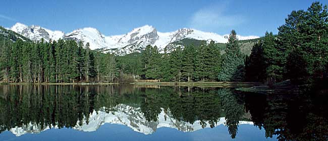


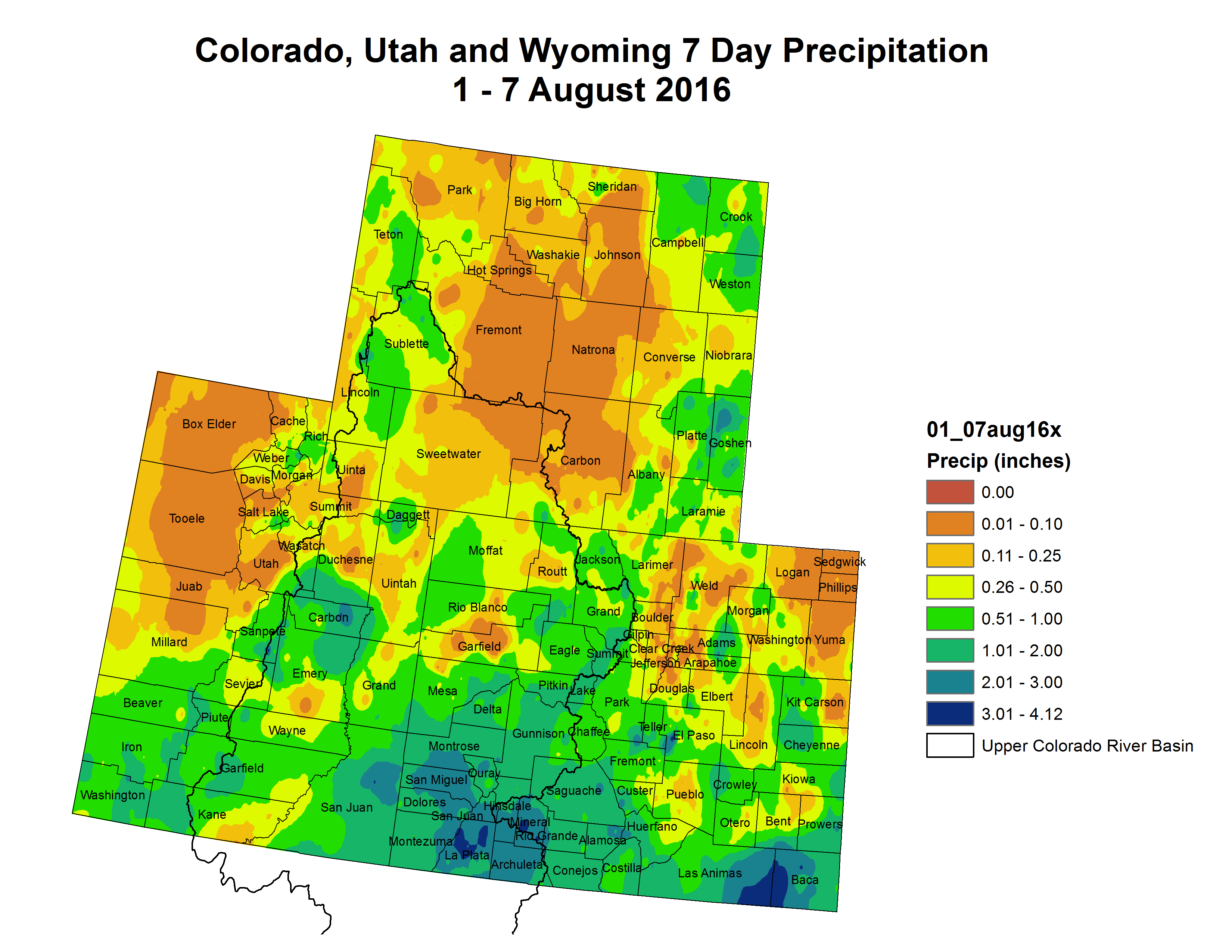


")


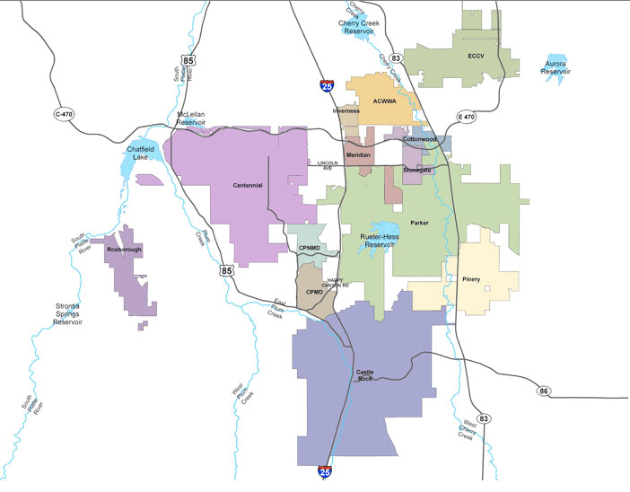
![This image was taken during the peak outflow from the Gold King Mine spill at 10:57 a.m. Aug. 5. The waste-rock dump can be seen eroding on the right. Federal investigators placed blame for the blowout squarely on engineering errors made by the Environmental Protection Agency’s-contracted company in a 132-page report released Thursday [October 22, 2015]](https://coyotegulch.blog/wp-content/uploads/2015/10/goldkingminespill1057am08052015viaepa.png)


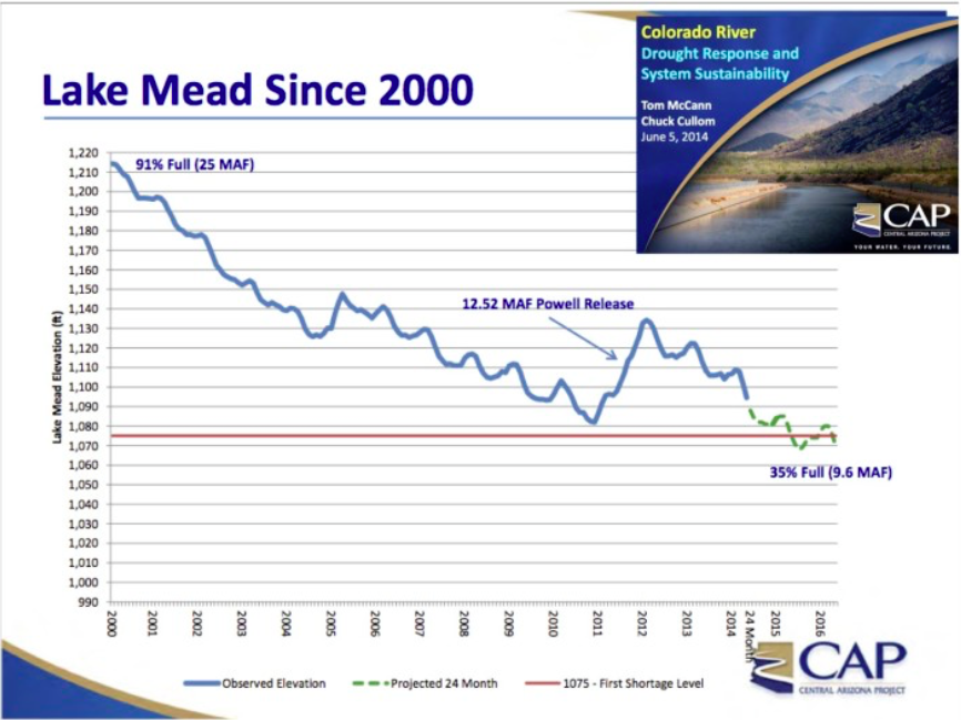
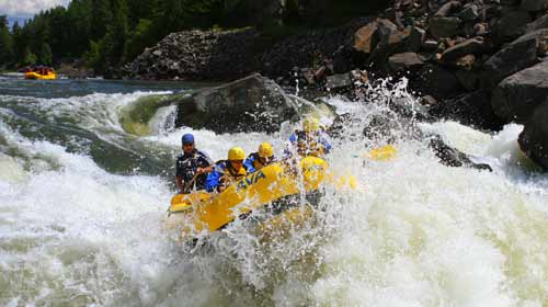


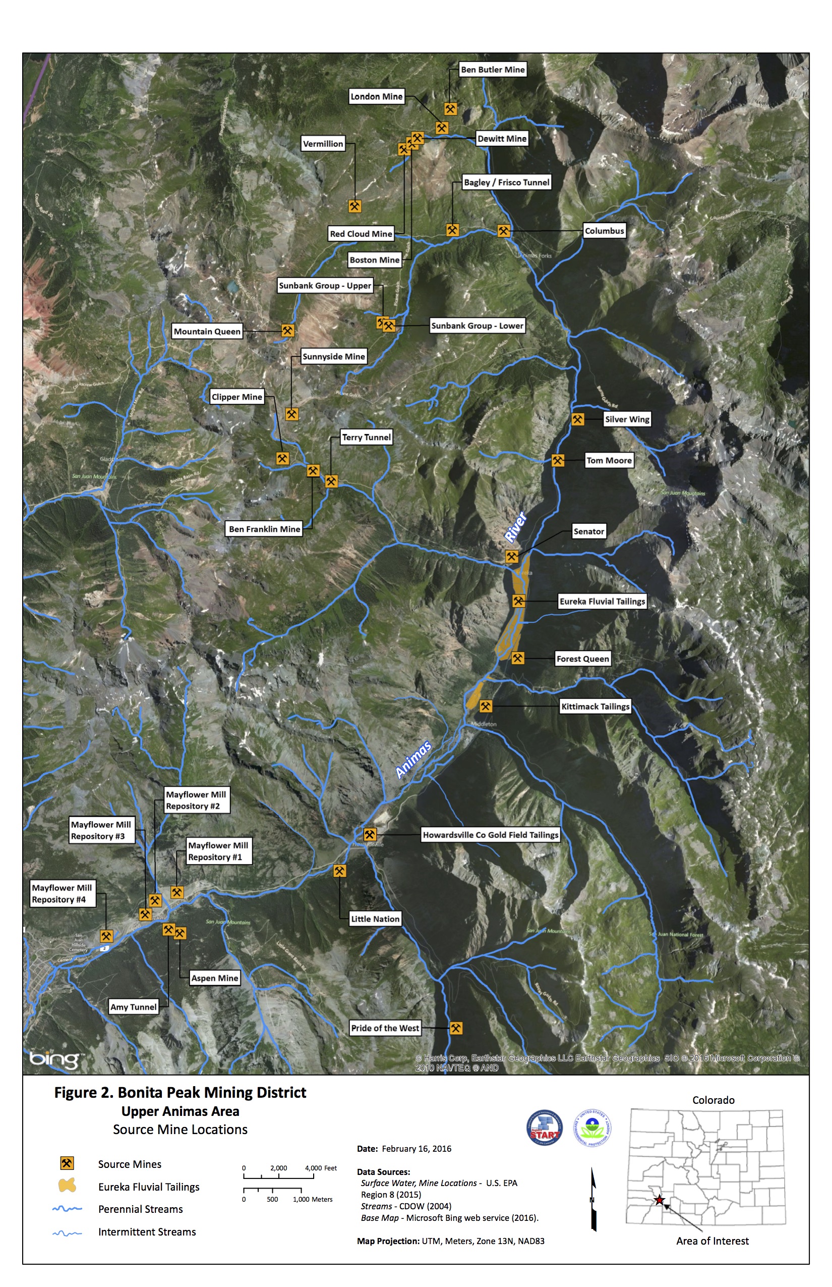

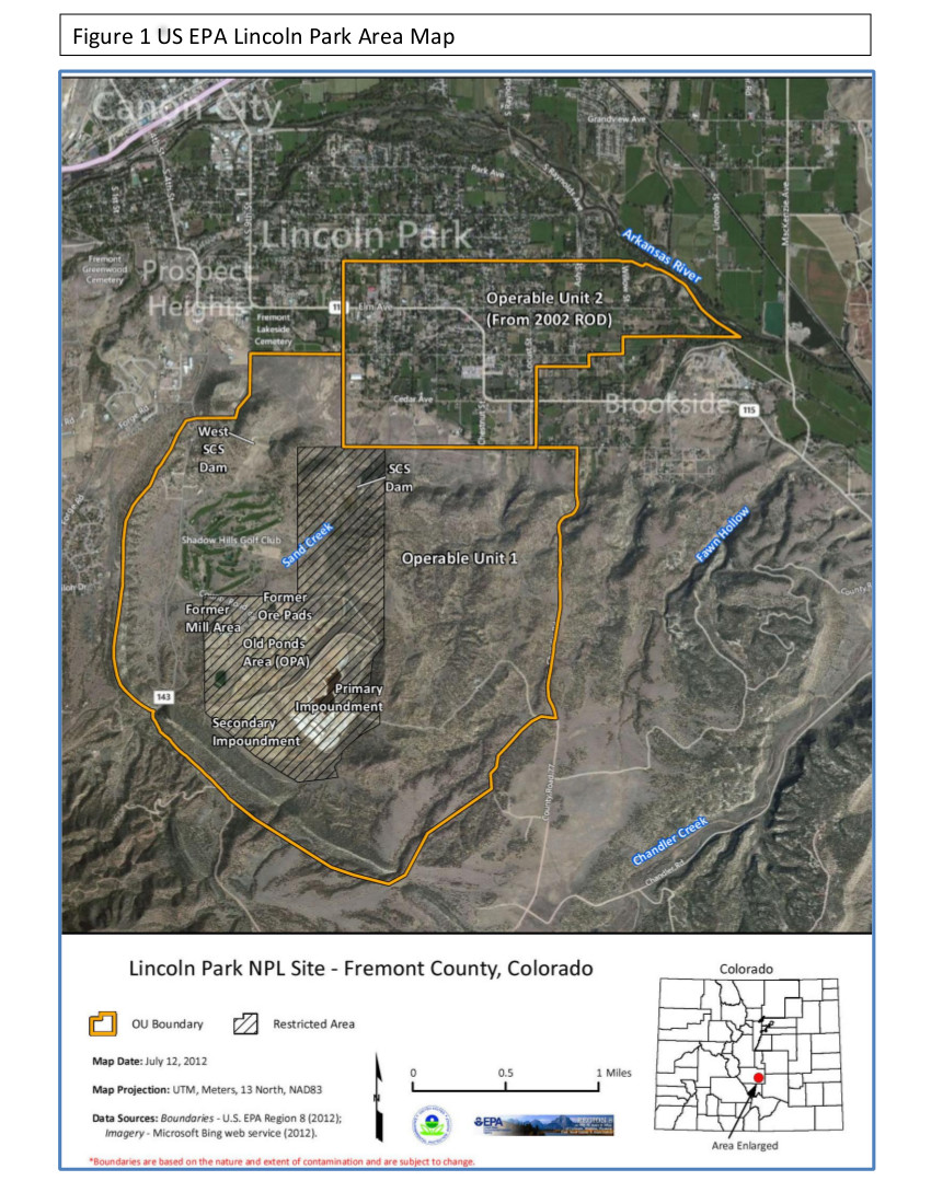
![This image was taken during the peak outflow from the Gold King Mine spill at 10:57 a.m. Aug. 5, 2015. The waste-rock dump can be seen eroding on the right. Federal investigators placed blame for the blowout squarely on engineering errors made by the Environmental Protection Agency’s-contracted company in a 132-page report released Thursday [October 22, 2015]](https://i0.wp.com/coyotegulch.blog/wp-content/uploads/2015/10/goldkingminespill1057am08052015viaepa.png?w=274&h=154&ssl=1 "goldkingminespill1057am08052015viaepa")


")
")

![Wastewater continued to stream out of the Gold King Mine on Tuesday [August 11, 2015] near Silverton, several days after a rush of 3 million gallons of it flooded Cement Creek and the Animas River. At the top of the photo is the mine’s opening, where an Environmental Protection Agency cleanup team was working with heavy machinery Aug. 5 and hit an earthen wall that had millions of gallons of water built up behind it](https://i0.wp.com/coyotegulch.blog/wp-content/uploads/2015/08/goldkingmine08132015deseretnewsgeoffliesik.png?w=332&h=233&ssl=1 "goldkingmine08112015deseretnewsgeoffliesik")