From The Grand Junction Daily Sentinel (Dennis Webb):
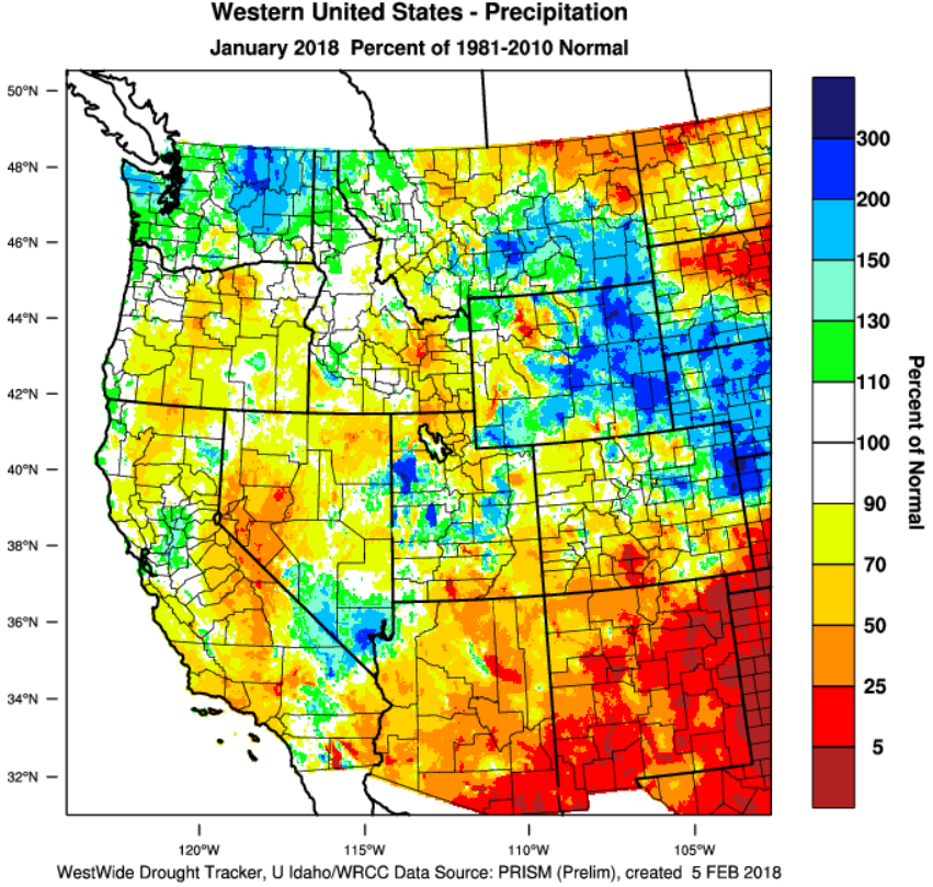
January was wetter than previous months in Colorado’s mountains, but still saw precipitation that was just 70 percent of average, which pretty much sums up the atrocious state of affairs when it comes to current snowpack levels.
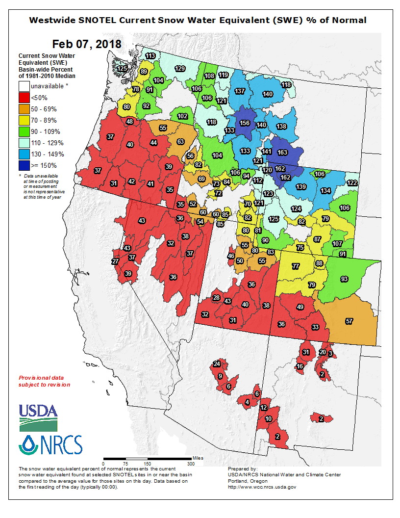
Statewide snowpack was at 64 percent of median Wednesday, according to Natural Resources Conservation Service data.
That’s up from 54 percent of normal Jan. 1, but the wetter January “can hardly be viewed as a reprieve from the tenacious pattern of dry weather,” the NRCS said in a news release Wednesday…
Brian Domonkos, Colorado snow survey supervisor for NRCS, said in the release, “Nearly one-quarter of the almost 200 snow monitoring sites across our network recorded snowpack at the lowest or second-lowest levels on record.”
Current snowpack levels range from 93 percent of median in the South Platte River Basin to just 33 percent in the Upper Rio Grande Basin. The Upper Colorado Basin is at 79 percent of median, and the Gunnison Basin is at just 49 percent, reflecting the sharp divide in moisture levels between northern and southern Colorado thanks to a La Niña weather pattern that typically brings more snow to the northern part of the state.
Domonkos said areas such as Wolf Creek Pass and Red Mountain Pass in the San Juan Mountains currently have just two or three feet of snow, compared to a typical five to six feet of snow in early February.
“What’s more concerning is the considerable number of mid- to lower-elevation monitoring sites that have little to no snow,” he said.
Some streams in the Upper Colorado and South Platte basins are forecast to have near-average streamflows this summer, but the Gunnison Basin forecasts range from 72 percent of average for the Slate River near Crested Butte to 27 percent for Surface Creek at Cedaredge.
The current streamflow forecast for the Plateau Creek drainage is 39 percent of average, another reflection of poor snowpack levels in the Grand Mesa area. Powderhorn Mountain Resort on Grand Mesa recently announced it was returning to a reduced, Thursday through Sunday operating schedule to help preserve snowpack higher on the mountain as the drought continues…
A saving grace for the state’s water outlook in coming months is reservoir storage, which the NRCS says is at the highest January level in many years, at 115 percent of normal. Gunnison Basin storage is at 104 percent of normal, and Colorado River Basin storage is at 116 percent.
As of Feb. 1, the Colorado Basin River Forecast Center was projecting that inflows into Lake Powell will be 47 percent of average during the runoff season. The reservoir, viewed by Colorado and other states in the Upper Colorado River Basin as their bank account for meeting downstream water-delivery obligations, is 56 percent full.
From The Greeley Tribune (Sharon Dunn):
Snowpack for the two basins that provide water to northern Colorado — the upper Colorado and South Platte River basins — still are cause for concern, despite the fact they are in a better spot than other basins around the state, said Brian Werner of Northern Colorado Water Conservancy District.
As of Wednesday, the upper Colorado was 79 percent of average while the South Platte was 93 percent of average. Statewide, snowpack is at 64 percent of average, now halfway through the season.
“Our biggest water-related months are March and April,” Werner said. “That’s where we get the wet, heavy spring snows that provide a lot of water to us. Our biggest months are still ahead of us.”
According to the U.S. Department of Agriculture, January’s statewide snowpack measured at 69 percent; that sank 5 percentage points by Wednesday. For January, a quarter of the state’s 200 snow monitoring sites across the state showed the lowest or second lowest levels on record, Brian Domonkos, Colorado Snow Survey supervisor, reported in a news release…
Northern Water on Wednesday had just conducted its first streamflow forecast for the year, as well. Based on that check, officials forecast that runoff — the amount of water that will flow through the rivers into local water supplies — will be at 80 percent to 90 percent of average come May and June. But that number can change every month.
The rest of the state may not be so lucky.
“While some streamflow forecasts in the South Platte and Upper Colorado River basins are projected to produce runoff within the range of normal, far more rivers and streams throughout the rest of Colorado are forecasted to provide below normal to well below normal runoff this spring,” the release stated.
Northern Colorado’s water supply is especially important to the agriculture industry throughout Weld County. The season has been dry and windy, and cause for concern. Soil moisture conditions were threatened due to a dry November, December and January, as well as heavy winds that tended to dry out the soil.
“That’s a concern with farmers, so some of the wet snows ahead could help us,” Werner said.
From The Denver Post (Bruce Finley) via The Loveland Reporter-Herald:
In southern Colorado river basins, the federal data through Feb. 7 showed snowpack in the Rio Grande River basin measured 33 percent of normal. In the combined San Miguel, Dolores, Animas and San Juan River basins, snowpack measured 35 percent of normal.
Northern Colorado fared wetter. Survey crews measured snow depths in the South Platte River basin that serves as a main source for metro Denver and northeastern farm fields at 93 percent of normal, and in the North Platte River basin at 88 percent of normal. The snowpack in the upper Colorado River basin that also is a key source of water for booming Front Range cities measured 79 percent of normal.
At this point with traditional winter passing, recovery to near-normal snowpack would require a major shift in ocean-driven weather patterns.
Temperatures also play a role. On Wednesday, the National Oceanic and Atmospheric Administration issued a bulletin noting that the average U.S. temperature in January was 2.1 degrees higher than the 20th Century average. Colorado ranked among nine western states where temperatures in January were much warmer than average.
The low mountain snowpack means water flows in streams this spring likely will fall far below normal.
However, Denver Water officials who supply water to 1.4 million people, said recent storms in mountains above its reservoirs brought snowpack at those locations to normal or better for this time of year.
“Denver Water is cautiously optimistic regarding snowpack,” spokeswoman Stacy Chesney said. “The next few months will determine the water available to us during spring runoff. It’s still too early to speculate on snow totals for the year because we often see good snow accumulation in March and April.”
Northern Water officials echoed that assessment.
“Obviously, we would rather be above average heading into February,” Northern Water spokesman Brian Werner said. “However, our two biggest water-producing snowpack months are ahead of us in March and April. The next three months will prove critical. We’ve seen years turn around completely in the spring with those good, heavy, wet snows that add to water supplies once they melt.
“Is there concern? Yes, especially for those in southwestern Colorado where the numbers are much worse,” he said. We like to see snow everywhere in the mountains this time of year.”
A few years ago when mountain snow stayed at record-low levels in California and Nevada, water shortages and droughts hit hard. California officials ordered urban water use restrictions. Here in Colorado, state officials leave water supply planning and drought response largely to the discretion of local governments and utilities.

Credit Colorado Basin River Forecast Center / National Oceanic and Atmospheric Administration
From the Associated Press via KTAR.com:
Hydrologist Greg Smith of the National Oceanic and Atmospheric Administration said Wednesday Lake Powell is expected to get 47 percent of its average inflow because of scant snow in the mountains that feed the Colorado River.
Smith says there’s only a 10 percent chance that enough mountain snow will fall during the rest of the winter to bring inflows back to average.
From Tucson.com (Tony Davis):
If you drive over Red Mountain Pass near Silverton, Colorado, north of Durango this weekend, you’ll see lots of snow, like every winter. But you’ll also see rocks and trees poking through the snow that you don’t normally see this time of year.
Those rocks and trees symbolize Rocky Mountain snowpack stuck at record-tying low levels for midwinter. These levels spell potential trouble for the spring-summer runoff that supplies much of Tucson and Phoenix’s drinking water, both for now and for the future.
The Upper Colorado River Basin snowpack in places like Red Mountain Pass, elevation 11,500 feet, feeds the river’s tributaries that drain into the main Colorado River, which supplies the Central Arizona Project serving Tucson, Phoenix and Pinal County cities and farmers.
Normally by now, Red Mountain Pass has had 12 winter snowstorms, said Jeff Derry, director of the nonprofit Center for Snow and Avalanche Studies in Silverton. This winter, it’s had four. Farther north, 2 feet of snow are piled in the mountain passes near Glenwood Springs in western Colorado, compared with 6 to 8 feet a year ago.
Overall, the Upper Basin’s snowpack recently has ranged from 63 to 65 percent of normal, says the federal Colorado River Basin Forecast Center. That ties with 1990 for the lowest snowpack on record for this time of year, the forecast center says.
The center predicts that April-July runoff into Lake Powell will be 47 percent of normal. That doesn’t make a CAP shortage likely next year. As of now, the federal government says the chance of such a shortage is only 17 percent for 2019.
But the risk rises to 49 percent in 2020, 58 percent in 2021 and 63 percent in 2022, say current U.S. Bureau of Reclamation forecasts based on computer models.
And Tom Buschatzke, director of the Arizona Department of Water Resources, is concerned that under the worst case scenario, Lake Mead could dip a half-foot below 1,075 feet by the end of 2018 and drop an additional 4.5 feet by 2020. A shortage is supposed to be declared if the lake drops below 1,075 feet, although he says additional water conservation could probably prevent that.
Arizona and the rest of the river basin have been through such worries before and came through unscathed. In winter and spring 2015, snowpack levels and runoff forecasts were grim through April. Authorities in Arizona were gearing up for the first-ever cutback in CAP deliveries in the following year.
Instead, Colorado was pounded by record rainfall the next month, which has since been dubbed “Miracle May,” and no 2016 shortage occurred.
Today’s long-range forecasts for the Colorado Basin don’t see miracles ahead. They predict a dry spring in areas of the Upper Basin south of Interstate 70, which covers the majority of Colorado and a good part of Utah.
There’s no way to predict a Miracle May because it didn’t happen in 2015 “until it was right on top of you,” said Eric Kuhn, retired general manager of the Colorado River District that manages water in western Colorado.
The immediate cause of this low snowpack is a combination of two extremely strong weather systems hanging over the region since November that have refused to move.
First, an Arctic-spawned low-pressure system — which Arizona water officials have dubbed “the Blob” — is centered over Canada’s Hudson Bay. It has held temperatures well below normal for much of the winter across the eastern and midwestern U.S.
Below that is a high-pressure system hanging over the eastern Pacific and the Southwest that has driven the jet stream northward and left much of the West warm and dry, including not only the Colorado River Basin but the Sierra Nevada Mountains in California.
“We unfortunately are dominated by this high-pressure ridge over the West, and it works in tandem with the really strong low pressure ridge to the east,” said Greg Smith, a hydrologist for the Colorado River Basin Forecast Center. “When these features are very strong, they can be persistent. These features have been persistent over much of the winter.”
Another potential, and probably likely factor, is climate change.
Studies have shown significant snowpack declines across most of the western U.S. since the 1950s, the Environmental Protection Agency has said. Human factors, including climate change, ozone depletion and land use, accounted for 20 percent of the loss in annual Western mountain snowpack since the 1980s, said an April 2017 study from Lawrence Livermore National Laboratory in Berkeley, California.
Peak runoff in streams and rivers of the West is strongly influenced by melting of accumulated mountain snowpack.
Based on the current state of the snowpack, the researchers predict a further loss of up to 60 percent within the next 30 years.
“The projected losses have serious implications for the hydropower, municipal and agricultural sectors in the region,” said John Fyfe, a research scientist for Environment and Climate Change Canada, and lead author of the study, published in the journal Nature Communications.
Brad Udall, a prominent Colorado State University water researcher, acknowledged there’s no way to be certain without additional study that this year’s poor snowpack is directly related to climate change caused by greenhouse-gas emissions.
But many of the weather patterns that are linked with this year’s poor snowpack “look like our future,” based on what other researchers have predicted will happen because of climate change, Udall said.
First, this year saw a late start to winter weather across the entire river basin and in California, he said.
Second, record-warm Colorado weather from October through December meant that a lot of snowpack evaporated and became water vapor instead of becoming stream runoff. Finally, this winter’s pattern of extremely dry weather south of Interstate 70 and the less dry weather north of I-70, is also what climate models have predicted, Udall said.
Over the past 18 years ending in 2017, only four years saw even average runoff down the Colorado, Udall said.
“That’s less than half of the big flow years on average that we used to get,” he said.