Day: February 6, 2018
Drought response preparations becoming more ‘routine’ for Eagle River Basin — @AspenJournalism
From Aspen Journalism (Heather Sackett):
Winter in the Eagle River Basin has gotten off to a slow start, leading water managers to keep a close eye on snowpack and spring streamflow predictions.
As of Wednesday, Jan. 17, the Upper Colorado River headwaters were at 84 percent of normal precipitation for this water year, which runs from October 2017 through September 2018. The current snow totals could have big implications for the region’s water provider, the Eagle River Water & Sanitation District.
The Eagle River Water & Sanitation District monitors three snow telemetry, or SNOTEL, snow-measurement sites: Vail Mountain, Copper Mountain, and Fremont Pass. The Vail and Copper sites indicate what spring runoff might look like in Gore Creek and the town of Vail, according to district Communications and Public Affairs Manager Diane Johnson.
The Fremont Pass site is near the headwaters of the Eagle River, which indicates what runoff might look like in Avon and Edwards. As of Tuesday, Jan. 16, the Vail SNOTEL site was at 49 percent of normal, while the Copper and Fremont sites were at 87 percent and 100 percent, respectively.
“As a local water provider, where we want to see what might be available for our customers is right here in our basin,” Johnson said.
The Eagle River Water & Sanitation District is the second-largest water provider on the Western Slope. While most of the water for Colorado’s Front Range is stored in large reservoirs, Eagle River Water & Sanitation District reservoirs are augmentation and not used for direct supply.
‘Paying closer attention’
Streams need to flow to supply water to customers. That’s why Eagle River Water & Sanitation District is keeping a close eye on snowpack levels and streamflow predictions.
“We are paying closer attention,” Johnson said. “By the end of February, we might move a little bit more on that.”
According to the January Natural Resources Conservation Service Streamflow Forecast Summary, the Eagle River below Gypsum is predicted to have a streamflow that is 79 percent of average. No forecast point in the state is predicting above-normal streamflows.
“Eagle looks to be reasonably well set up to have potentially near-average streamflows,” said Karl Wetlaufer, a hydrologist with the Natural Resources Conservation Service snow survey. “Eagle is kind of in the middle of the pack, but in general, that region is faring as well as anywhere in the state.”
While Johnson said the Eagle River Water & Sanitation District does not feel either anxious or optimistic yet, staff members have been reviewing procedures from 2012, should 2018 turn out to be another drought year.
One of the biggest water savings comes from reducing outdoor use such as watering lawns and landscaping. According to Johnson, about 95 percent of water used indoors returns to the river after it’s been treated and somewhere between 15 percent and 40 percent of water used outdoors returns to the river.
“Indoor use has much less of an effect on the overall streamflow,” Johnson said. “So for us, that is a really huge thing around how we operate in low water years.”
In 2012, Eagle River Water & Sanitation District held stakeholder meetings throughout the spring, so water users were aware they might be asked to cut back. The goal was to find a healthy balance between using less water but not negatively impacting the economy or home values, part of which is having aesthetically pleasing greenery and landscaping.
Watering schedule
An outdoor watering schedule that permits watering three days a week before 10 a.m. or after 4 p.m. is in effect year-round. Unlike other water providers, where restrictions may be triggered when a reservoir dips below a certain level, Eagle River Water & Sanitation District does not have a specific threshold when more stringent regulations would be implemented.
Johnson said the district made some operational changes to respond to the 2012 drought, such as reassigning staff, closely monitoring streamflows, and fireproofing the valley’s 50 water storage tanks and booster pump systems.
Although they are not switching gears just yet, if dry conditions continue in Eagle River Water & Sanitation District’s service area again this year, then the water provider will respond much as it has in years past, Johnson said.
“I would say we are prepared,” Johnson said. “We have done this before. It’s kind of a bummer that it was only six years ago. I think as the new normal is established, a lot of this is becoming routine. We did not have water regulations prior to the 2000 drought, but by 2012, the regulations were known. We are investing a little bit of time now, but it’s too early to go full force.”
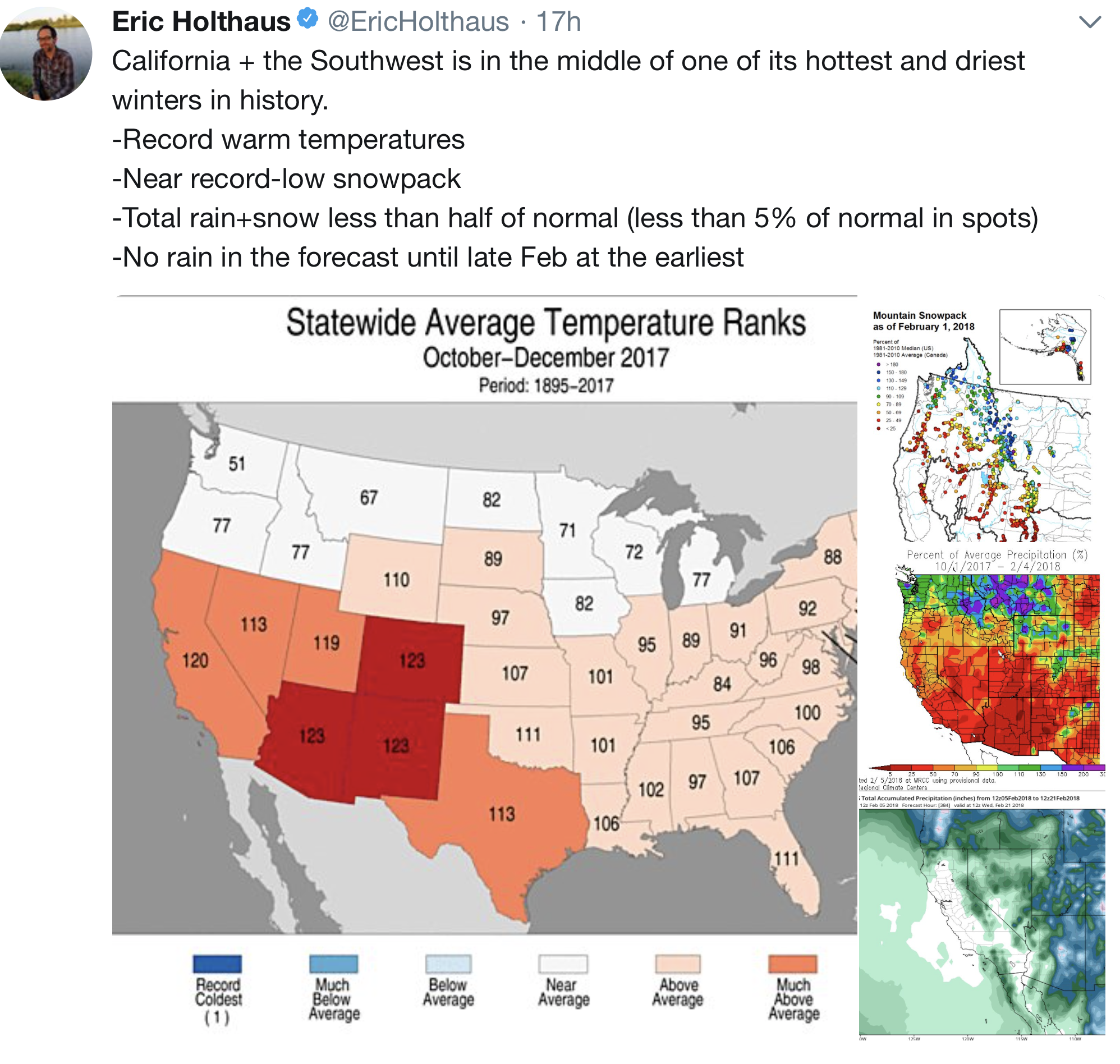
The statewide stats are stark. According to Wetlaufer, as of Tuesday, the 2018 water year has received just five inches of snow-water equivalent to make for the third-lowest snowpack statewide on record. Only 1980 and 2000 were drier, with 3.7 inches and 4.8 inches of snow-water equivalent, respectively.
Not even last week’s storms made much of a difference on a Colorado River Basin-wide scale. But snowpack totals vary by region, with the northern part of the state generally doing better than the southern half.
“The San Juans have seen it the most with very minimal precipitation for the last four months. … We are dealing with a pretty substantial deficit at this point,” Wetlaufer said.
Editor’s note: Aspen Journalism is collaborating with the Vail Daily, the Summit Daily, The Glenwood Springs Post Independent, and The Aspen Times on coverage of rivers and water. The Vail Daily published this story on Friday, Jan. 19, 2017.

The latest “The Current” newsletter is hot off the presses from the Eagle River Watershed Council

Click here to read the newsletter. Here’s an excerpt:
Where does all the traction sand go on Vail Pass?
The arrival of snow means traffic on I-70 over Vail Pass bustles with skiers and visitors to and from the Front Range, with cars braving storms and bumper-to-bumper traffic in search of a powder day. Without the help of traction sand or de-icers, our ability to constantly travel across the state would not be possible.
Roughly 5,000 tons of traction sand are laid down on Vail Pass each year, but where does all that sand end up? Originating from aggregate mines from the Western Slope and stored in the igloo tent atop Vail Pass, the sand is sprinkled along the highway corridor to ensure safer travel along the pass. Colorado Department of Transportation (CDOT) enlists contractors each year to come through in the late summer with vacuum trucks to suck up the remaining sand on the road ways and median. The used sand is then brought down to the berms that line the north side of the highway in East Vail. Sand is also flushed by rain and snow over the embankments and carried into sediment-catch basins or into Black Gore Creek, which closely parallels about 10 miles of the interstate from its headwaters at Vail Pass to the confluence of Gore Creek.
Extensive sediment loading to Black Gore Creek from nearly three decades of I-70 operations have severely impaired the stream, resulting in losses of aquatic habitat, impacts to wetlands and an overall reduction in water quality. In addition, the accumulation of sediment in Black Lakes near Vail Pass encroaches upon the storage capacity of water supply reservoirs that serve Vail and are used to maintain instream flows.
Black Gore Creek Steering Committee’s Efforts
Since 1997, the Black Gore Creek Steering Committee (BGCSC), headed by Eagle River Watershed Council, has worked to mitigate the impacts to Black Gore Creek and the health of its aquatic life. The committee is made up of a number of important partners in the community, including Eagle River Watershed Council, Colorado Department of Transportation, Eagle County, U.S. Forest Service, Town of Vail, Eagle County, Eagle River Water & Sanitation District, Lotic Hydrological, River Restoration, Colorado Parks & Wildlife, Colorado Department of Public Health & Environment, and concerned citizens.
In 2002, Black Gore Creek was listed on the State’s 303(d) list of impaired waters for sediment—which is different than Gore Creek’s more recent listing in 2012 for aquatic life impairment. Although the State has yet to come out with a limit of how much traction sand can enter the creek, CDOT, in collaboration with the other BGCSC partners, has taken great initiative to address these issues over the past 10 years.
Recent Accomplishments
To date, CDOT is picking up nearly the same amount of traction sand as they are putting down annually, which has improved since the years when no cleanup occurred, and the basins slowly filled.
Besides capital improvement projects such as repaving the medians and bike path enhancements, one of the most significant improvement projects has been the identification of a long-term maintenance solution for the Basin of Last Resort. A 3-acre section of Black Gore Creek around mile marker 183 on I-70, the Basin is a control structure that traps sediment missed by upstream catch basins. There has been concern with its effectiveness as the basin fills with sediment. In the fall of 2017, construction of a road allowing for easier access to excavate the basin more regularly and efficiently was finalized.
More work is to be done, however, as the goal is to have less sediment reach the Basin of Last Resort in the first place. Through field assessments, mapping activities, and sediment transport modeling, consultants to Eagle River Watershed Council, namely River Restoration and Lotic Hydrological, are working to identify opportunities for capturing traction sand before it leaves the highway corridor and enters the creek.
Traction Sand vs. Mag Chloride
CDOT has also installed sophisticated software in their plowing vehicles that senses how much traction sand or de-icer they should be applying on any given segment of the highway. The increased prevalence of de-icers, commonly referred to as “mag(nesium) chloride,” has been an inevitable outcome from the pressure on CDOT to reduce the amount of traction sand applied. Although very effective at melting snow and preventing ice formation, de-icers aren’t without their downsides. Studies have shown that elevated levels of chloride in rivers can be detrimental to aquatic life. The Watershed Council and CDOT both conduct chloride-loading studies to understand how chloride concentrations differ in Black Gore Creek and Gore Creek and whether they are approaching harmful levels.
“We don’t see the kinds of widespread impairments of the biological communities on Black Gore Creek that you would expect if they were really being negatively impacted by chloride. The health of those communities may be somewhat limited, but they do not meet the Colorado State definition for impairment right now,” reports Seth Mason of Lotic Hydrological. That is not to say that we shouldn’t be concerned about chloride levels in Black Gore Creek. While macroinvertebrate communities in Black Gore Creek may look better than those on Gore Creek through Vail, they may be stressed by elevated chloride concentrations and more vulnerable to other impacts on the creek. While more studies chloride’s effects are needed, the BGCSC is committed to not replacing one pollutant with another.
Related to Gore Creek’s Woes?
With all the recent attention on the Restore the Gore effort surrounding Gore Creek, some long-time locals believe the impacts from Black Gore Creek are at fault. Up until 2012, the State associated high sediment levels automatically with impaired aquatic life. In conducting macroinvertebrate sampling in our watershed, we are finding that aquatic bug scores on Black Gore Creek are healthier than those in the highly developed sections of Gore Creek through Vail. This along with other evidence leads to the belief that stormwater runoff from impervious surfaces in town and the loss of riparian areas along Gore Creek from development are a greater contributor to Gore Creek’s impairments.
The important efforts on Vail Pass have not slowed–in fact CDOT has spent about $7 million since 2013 to clear out the catch basins and sweep our roadways. The Watershed Council will continue the collaborative dialogue and mitigation efforts of the stakeholders to ensure the important progress continues in keeping our waterways healthy and clean.
CU Boulder announces membership in new University #ClimateChange Coalition
Here’s the release from the University of Colorado at Boulder:
CU Boulder on Tuesday announced it has joined the University Climate Change Coalition (UC3), a newly formed coalition of 13 leading North American research universities that have united to help communities achieve their climate goals and accelerate the transition to a low-carbon future.
UC3’s initial cohort of member institutions—representing distinguished universities from the United States, Canada and Mexico—formally unveiled the initiative at the Higher Education Climate Leadership Summit in Tempe, Arizona, during a panel discussion that included CU Boulder Chancellor Philip DiStefano.
“With our university partners in UC3, we can meet the challenges of climate resiliency and sustainability,” DiStefano said. “Through leadership and innovation, together we can positively impact humanity now and for generations to come.”
CU Boulder Chief Sustainability Officer Heidi VanGenderen will serve as the primary campus liaison for the UC3 endeavor, working closely with Vice Chancellor for Infrastructure and Safety David Kang, Vice Chancellor for Research & Innovation Terri Fiez and other campus leaders.
For more than half a century, CU Boulder has been a leader in climate and energy research, interdisciplinary environmental studies programs, and engaging in sustainability practices both on campus and beyond. These endeavors fit within CU Boulder’s mission to improve communities through collaborative research, innovation and entrepreneurship.
Campus leaders have set a goal of reducing greenhouse gas (GHG) emissions by 20 percent by 2020 from a 2005 baseline, a 50 percent reduction by 2030, and an 80 percent reduction by 2050.
It is with this blend of history, expertise and determination that CU Boulder will contribute to the efforts of UC3, which aims to foster an exchange of best practices and lessons learned in pursuit of carbon neutrality and greenhouse gas reductions. Together, these institutions have committed to mobilizing their collective resources and expertise to help businesses, cities and states achieve their climate goals.
Two of UC3’s major initiatives in its first year include:
Cross-sector forums: Each UC3 institution will convene a climate change summit during the 2018 calendar year to bring together community and business leaders, elected officials and other local stakeholders. Summits will be tailored to the local and regional context and will focus on proven, research-tested policies and solutions that can help communities achieve their climate goals and/or plan for resiliency in the face of a changing climate. Coalition climate mitigation and adaptation report: A coalition-wide report, to be released in late 2018, will synthesize best practices, policies and recommendations from all UC3 forums into a framework for continued progress on climate goals across the nation and the world.
UC3 will operate in close partnership with Second Nature’s Climate Leadership Network, a group of hundreds of colleges and universities, of which CU Boulder is also a member, that have committed to taking action on climate.Harnessing the exceptional resources and convening power of member institutions, the coalition will work to inform and galvanize local, regional and national action on climate change. Coalition members will bring to these efforts a critical body of expertise in areas including climate modeling, energy storage systems, next generation solar cells, energy-efficiency technologies, smart grids, transportation sector innovations, regulatory and policy approaches, and more.
In 2015, the U.S.-based members of the UC3 coalition together performed almost a quarter of the environmental research conducted by all U.S. institutions, according to data collected by the National Science Foundation.
“The research university has played an important role in creating new knowledge, convening thought leadership and serving as long-term community members,” Second Nature President Timothy Carter said. “By applying these strengths to locally relevant climate challenges, we see transformative potential for accelerating climate solutions in these locations in a way that couldn’t happen if the institutions and sectors continued to act on their own.”
Water Values podcast: Ensuring Technology Access and Resilience in the Field with David Dolphin
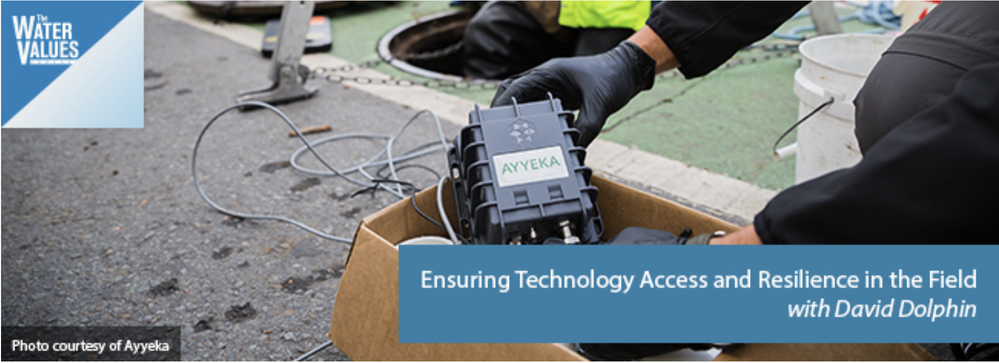
Click here to listen to the podcast (David McGimpsey):
David Dolphin, of utility technology provider Ayyeka, discusses a wide range of issues related to end-to-end remote monitoring system deployment. David covers signal strength, data encryption, battery life and other issues that utilities need to consider when evaluating a remote monitoring technology solution. You’re guaranteed to learn something by listening!
Plus, this episode also has Reese Tisdale in our Bluefield on Tap segment where Reese discusses big picture issues in the water sector, including the slow-moving train wreck that resulted in Cape Town’s water emergency.
In this session, you’ll learn about:
How signal strength affects remote monitoring solutions Why having a remote monitoring solution that connects to multiple networks is important Considerations for battery life in a remote monitoring technology Using remote monitoring solutions with GPS/GIS technology to identify trends or hot spots How data encryption factors into a remote monitoring solution How materials maintain waterproof qualities in distribution or collection systems
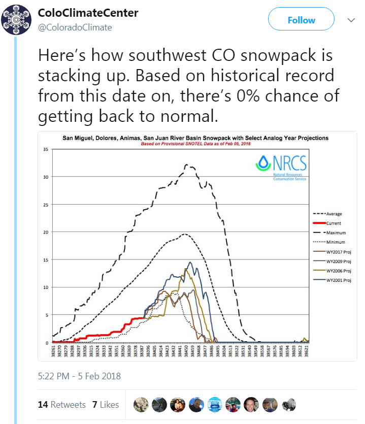
#LaNiña effects expected to last through the winter into spring #drought

From The Durango Herald (Jonathan Romeo):
During this period of La Niña, which can last up to five months, little, if any, precipitation makes it to Southwest Colorado as storms are pushed up to the northern parts of the state.
And this year, Cuoco said it’s playing out like a classic La Niña year.
As of Sunday, Southwest Colorado’s snowpack is at 34 percent of normal averages, while the Colorado, North and South Platte, and Yampa river basins are experiencing upwards of 75 percent of normal snowpack.
According to NWS data, only 0.39 inches of precipitation were recorded at the Durango La Plata County Airport for the entire month of January, about 1.12 inches below historic averages.
Last year, which was an El Niño year, more than 2.35 inches of precipitation was recorded for the month of January at the Durango-La Plata County Airport weather station.
Also, this past January was nearly 5.5 degrees warmer than historic averages.
The U.S. Drought Monitor lists nearly all of Western Colorado and the Four Corners region in a “severe drought.”
And unfortunately, NWS models show no signs of La Niña going anywhere anytime soon.
While scientists are able to track and measure global oceanic circulations, and know how these cycles move, they are less certain about the driving forces behind it, Cuoco said.
“What causes surface water temperatures in the ocean to warm back up toward normal, or to cool down?” Cuoco said, “we really don’t have that answer yet.”
Cuoco said the World Meteorological Organization, an intergovernmental organization comprised of 191 countries and territories, has been funding research to get at the answer for years.
These oscillations in surface water temperature have resounding impacts on weather conditions around the globe.
In El Niño years, for instance, parts of Southern Africa, the Philippines, Mexico and Central America may experience extreme drought, while areas like Bolivia, Ecuador and Cuba may get hit with catastrophic flooding.
Therefore, understanding what causes a particular year to have warm or cold surface water temperatures is a question sought after by the international community, Cuoco said.
“It’s something that has been well funded with widespread research in the hopes of understanding,” he said.
As for Southwest Colorado and its parched landscape, any hint of snow comes as a bit of good news.
Cuoco said there’s a slight chance the high country north of Durango – areas around Silverton, Hesperus, Rico and Ouray – have a 30 to 40 percent chance of scattered snow showers Monday through Tuesday.
If the storms pan out, it may drop a couple of inches, Cuoco said.
#Snowpack news: Inflow forecast to #LakePowell = 47% of average #ColoradoRiver #COriver

Credit Colorado Basin River Forecast Center / National Oceanic and Atmospheric Administration
From KUNC (Luke Runyon):
Be prepared for some of the West’s biggest and most important rivers and streams to see record low flows this spring and summer.
That’s the message of the Colorado Basin River Forecast Center’s latest water supply forecast released Monday.
“Below average precipitation continued to be the norm and not the exception for the month of January,” the forecast report reads. “January marks the fourth consecutive month of the 2018 water year with widespread below average precipitation.”
The center’s forecasters are projecting the flows into Lake Powell — one of the largest human-made lakes in the country — to be 47 percent of average. The lake, on the Utah-Arizona border, is part of a reservoir system that supplies water to some 40 million people in the southwest. As of early February Lake Powell was at 56 percent of full capacity, while its sister reservoir, Lake Mead, was at 41 percent of full capacity.
The news is worse in the Colorado River’s lower basin, which includes Arizona, and portions of New Mexico and Nevada. In those states, spring runoff from February to May is projected to be be less than 30 percent of median.
The lowest water supply forecasts in the Upper Colorado River include the Dolores and San Juan Rivers in southwest Colorado, and across central and southern Utah including the Virgin, Sevier, and San Rafael River Basins.
Parts of the southern Rocky Mountains are currently experiencing the warmest and driest winter on record. Snowpack eventually turns into the region’s water supply, and without it, rivers and streams suffer. Snow measurement sites in southern Colorado, central Utah, and Arizona are reporting their lowest levels on record…
Last year’s above-average snowfall in the southern Rockies boosted reservoir levels throughout the region giving water managers some buffer to withstand a dry year, with both Arizona and New Mexico being the exception. Those two states are currently reporting below average reservoir storage.
From The Fort Collins Coloradoan editorial board:
The unusually dry winter has people in Colorado and across the West talking about the vagaries of the weather. But the more important conversation is about climate change.
Reporter Jacy Marmaduke wrote an interesting story that ran in the Jan. 28 print version of the Coloradoan — and, of course, on Coloradoan.com — about how climate change is affecting the state’s ski industry and how that impact is predicted to worsen in the decades to come.
There was a lot of bad news for fans of winter outdoor activities such as hitting the slopes at resorts in Summit County or snowshoeing in the upper reaches of the Poudre Canyon. Although snowfall amounts vary from year to year, the overall trend for the snowpack is less accumulation and earlier melting than in years past.
Snowpack has decreased 20 to 60 percent at most monitoring sites in Colorado since the 1950s, according to an Environmental Protection Agency analysis. Colorado’s average temperature has increased more than 2 degrees in the past 40 years.
Those trends are expected to continue. For ski resorts, decreasing snow translates to shorter ski seasons. The economic impact of that on resorts and the state’s vital tourist industry is profound.
However, there’s more for Coloradans to worry about than the financial well-being of ski resorts and the number of powder days skiers may enjoy. Our mountains hold the headwaters of major rivers, including the Colorado River, that supply water to a large part of the country.
Decreased snowpack and earlier runoff because of the shifting climate will require significant changes to how water is managed and conserved in river basins across the West. Other impacts include serious threats to agricultural production as well as healthy forests and rivers.
So what can individuals and society do about this? We can’t make more snow fall or otherwise change the weather, but we can take steps to lessen our contribution to forces science tells us are factors in climate change.
Local entities such as the city of Fort Collins, Colorado State University and Platte River Power Authority are leading the way in climate action through programs and policies aimed at reducing the community’s emission of greenhouse gases.
The city’s Climate Action Plan is one of the most aggressive municipal plans in the country, if not the world. The plan calls for dramatic reductions in greenhouse gas emissions in the coming years, with the goal of the community being carbon neutral by 2050.
These conservation goals will not be easily achieved. Getting there will require the cooperative efforts of individuals and large organizations alike.
A good source of information on Fort Collins’ work on climate action may be found on the city website fcgov.com/climateaction. The site includes access to a Climate Action Plan dashboard, which gives a snapshot view of the community’s progress on meeting its goals.
The dashboard is a work in progress, with some informational entry points labeled “coming soon.” But it provides access to reports on the city’s activities, including an Innovation Summit planned Feb. 12 to brainstorm ways to achieve Climate Action Plan goals.
Some might say that given the worldwide scope of climate change and the tremendous challenges it presents, efforts by one community in Northern Colorado to address it are not likely to make any difference.
A less cynical way of looking at climate action is that steps taken at the local level could provide important momentum toward finding answers to a big problem.
And we are not alone. Communities and countries around the world are taking action in the face of climate change in hopes of ensuring a livable world for future generations.