From The Grand Junction Daily Sentinel (Dennis Webb):
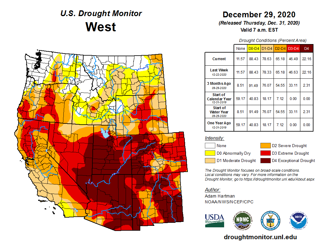
Drought continues to grip the entire state of Colorado, and drought more regionally continues to drive increasing concerns about the adequacy of water supplies throughout the Colorado River Basin given the drier and warmer weather that generally has prevailed through much of the 21st century. That has added urgency to efforts by Upper Basin states such as Colorado to continue exploring measures to reduce water demand by agriculture, cities and other users in times of drought to help head off the possibility of a mandatory curtailment of uses under an interstate compact.
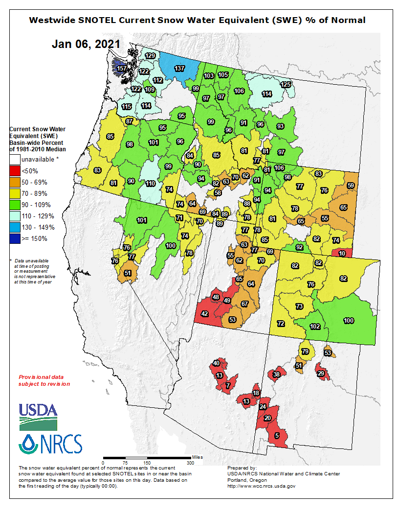
With snowpack below average so far, this winter has offered little promise of reversing the continuing dry trend. But the winter is young and a few big storms can improve the outlook quickly, which is why everyone from ranchers to municipal water providers to firefighters will be listening closely in coming months to what forecasters have to say about what weather is in store…
 The road to Bears Ears via the Salt Lake Tribune.
 The Antiquities Act of 1906 was signed into law by Theodore Roosevelt, for “… the protection of objects of historic and scientific interest” through the designation of national monuments by the President and Congress. National monuments are one of the types of specially-designated areas that make up the BLM’s National Conservation Lands. Some of the earliest national monuments included Devils Tower, the Grand Canyon, and Death Valley. They were initially protected by the War Department, then later by the National Park Service. More recently, the BLM and other Federal agencies have retained stewardship responsibilities for national monuments on public lands. In fact, the BLM manages more acres of national monuments in the continental U. S. than any other agency. This includes the largest land-based national monument, the Grand Staircase-Escalante National Monument in Utah featured here. National monuments under the BLM’s stewardship have yielded numerous scientific discoveries, ranging from fossils of previously unknown dinosaurs to new theories about prehistoric cultures. They provide places to view some of America’s darkest night skies, most unique wildlife, and treasured archaeological resources. In total, twenty BLM-managed national monuments, covering over five million acres, are found throughout the western U. S. and offer endless opportunities for discovery. Photos and description by Bob Wick, BLM.
Meanwhile, the Biden administration’s actions on other matters related to public lands and the environment should prove interesting in coming months. For example, Biden could decide to reverse the Trump administration’s decision to shrink the size of the Bears Ears and Grand Staircase-Escalante national monuments in Utah.
Among other actions that would draw strong reactions pro and con, he could follow through on a campaign promise to ban oil and gas leasing and drilling on federal lands. Such a move likely would be cheered heartily by some conservationist and activist groups concerned about the greenhouse-gas, public health and other impacts of oil and gas development.
But the Western Energy Alliance industry group already has promised a legal challenge of such an action, which a University of Wyoming professor has estimated would result in Colorado in an annual average loss of $73 million in tax revenues from 2021-25 and average annual job losses in the state nearing 5,200 over that same timeframe…
LOVED, HOPEFULLY NOT TO DEATH
Public-land use is yet one more issue where what has happened in 2020 raises questions about what might come in 2021. With all the limitations that COVID-19 forced on people, one way they responded was to head in huge numbers into the great outdoors where the socially distanced solace of scenery and fresh air has provided a balm for the malaise of pandemic-related restrictions.
Colorado Parks and Wildlife, the BLM, the Forest Service and the National Park Service all reported strong visitation numbers, from hikers to boaters to back-country skiers.
While those agencies love the fact that people are enjoying the lands and facilities they manage, they cringe at the many problems that can result, such as trail heads overflowing with cars, illegal camping and improper disposal of human waste.
This year, we can only hope, the threat from COVID-19 will subside as vaccination rates increase. It will be interesting to watch if public land visitation eases as well. Here’s guessing that it won’t, at least not by much.
Who, having discovered the joys of getting outdoors and enjoying the lands that belong to all of us, wants to then go backward, retreating to a life involving more indoor pursuits?
We love our public lands, perhaps now more than ever. The trick for us, and for those challenged with managing those lands, is how to prevent our loving them to death.