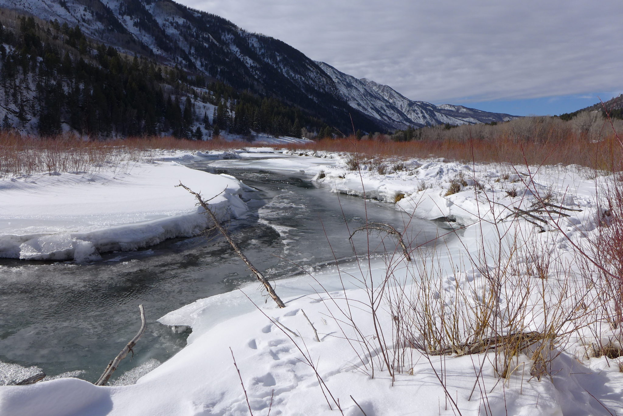
The Crystal River flows through the town of Marble just after its confluence with Yule Creek. Gunnison County, Pitkin County and local environmental groups want to see a marble mining company mitigate its illegal relocation of a creek by improving downstream riparian habitat. Photo credit: Heather Sackett/Aspen Journalism
The U.S. Army Corps of Engineers has denied local groups’ request for a public hearing in the case of a marble quarry that violated the Clean Water Act.
In a Dec. 28 letter to Pitkin County and others, Benjamin Wilson, project manager for the Army Corps’ Colorado West Section, said the agency does not intend to conduct a hearing or public meeting.
“We do not believe there would be a valid interest served or that we would receive any substantial new information we would not otherwise obtain through the public notice comment and review process we are currently engaged in,” the letter reads.
In separate comments submitted to the Army Corps, Pitkin and Gunnison counties, the Crystal River Caucus, the Roaring Fork Conservancy and the Crystal Valley Environmental Protection Association (CVEPA) had asked for monitoring, restoration, mitigation and a chance for the public to weigh in about the situation at the Pride of America Mine, which sits above the town of Marble.
“We are definitely not going to accept this,” said John Armstrong, director of CVEPA. “To not even offer to hear what the public has to say in a public hearing is kind of shocking to me.”
In the fall of 2018, mine operator Colorado Stone Quarries (CSQ) diverted a roughly 1,500-foot section of Yule Creek from its natural channel on the west side of Franklin Ridge, a rock outcropping, to the east side of the ridge so that it could build a road. Operators piled the streambed with 97,000 cubic yards of fill material, including marble blocks.
In March, the Army Corps determined that these actions, which were done without the proper permit, violated the Clean Water Act. CSQ is now retroactively applying for that permit, known as a 404 individual permit. Under Section 404 of the Clean Water Act, a project requires a permit from the Army Corps if it includes the discharge of dredged or fill materials into waters such as rivers, streams and wetlands.
In its permit application, CSQ proposed making the creek relocation permanent by leaving it where it is on the east side of the ridge. The company says this is the most efficient and environmentally sound option, and it results in the closest return to pre-diversion stream conditions.
Wilson said the Army Corps received more than a dozen comments, which have been forwarded to the mining company, along with additional questions from the Army Corps. Wilson said mining company officials must address these comments and propose a plan to mitigate the damage caused by the creek relocation. The deadline for the quarry to respond is Jan. 23, but Wilson said it will probably take the company longer than that to come up with a mitigation plan.
“We are working towards figuring out which alternative is indeed the least environmentally damaging,” Wilson said in an interview with Aspen Journalism. “I think it’s understood that no matter what alternative we choose to go forward with, additional mitigation will be required.”
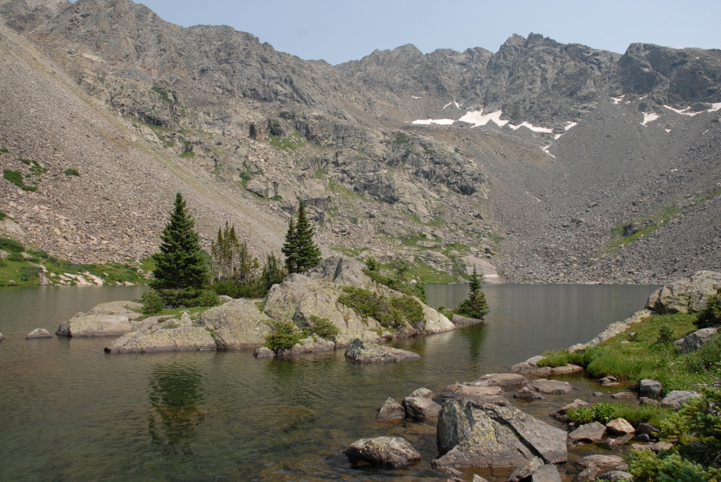
The Filoha Meadows area of the Crystal River is one of the places that could benefit from riparian revegetation to improve water quality. Pitkin County would like a mining company to undertake mitigation projects in the Crystal River valley to compensate for damage caused when the company relocated a high-country creek. Photo credit: Heather Sackett/Aspen Journalism
Pitkin County wants the mining company to restore the riparian habitat, conduct water-quality monitoring at multiple sites in the basin and compensate for any damage by doing restoration projects in other areas. County representatives identified eight projects that could provide compensatory mitigation in the Crystal River basin, including restoration of Filoha Meadows streambanks, Thompson Creek riparian restoration and Crystal River streambank stabilization.
Carbondale-based Wilderness Workshop agrees. The conservation organization is also getting involved in the issue, signing on to the comments provided by CVEPA.
“It is a shocking issue,” said Peter Hart, conservation analyst and staff attorney for Wilderness Workshop. “Obviously, the damage is done, but I think that we’d like to see fines for violations imposed and see those funds actually utilized for restoration projects in the Crystal River valley.”
CSQ senior consultant Katie Todt, who is with Lewicki & Associates, said the company is evaluating potential mitigation options, including improvements to the current stream channel within the quarry’s permit area, which should stabilize the creek bank and promote vegetation growth. The company will more fully set out mitigation options in its expected Jan. 22 response to the Army Corps.
Wilson said that even though there won’t be another opportunity for the public to formally provide comments, the Army Corps is still obligated to consider any new information that comes to light.
Assistant Pitkin County Attorney Laura Makar said it was disappointing that the Army Corps decided not to hold a public hearing, especially since this is an atypical, retroactive permit application, submitted after the work needing a permit was already complete. There was significant information that could have been shared in a public hearing, she said.
“It would have been a good opportunity to ensure the record was complete,” Makar said.
This story ran in the Jan. 8 edition of The Aspen Times.
In the spring of 2020, FIS Worldpay, a payment-processing company, sent more than 200 of its Durango, Colorado-based employees home to work remotely, in order to stem the spread of the novel coronavirus. Even when pandemic-avoidance measures were loosened over the summer and many workplaces filled back up, the 81,000-square-foot building remained dark. Then, in November, the Jacksonville, Florida-based company announced that the staff would continue to work remotely, and that the Durango building — the largest of its kind in town — would close for good.
This phenomenon — one-time cubicle workers becoming full-time telecommuters, liberated from corporate headquarters — deprived Durango of one of its largest private employers and has driven up office vacancy rates nationwide. Yet at the same time, it is also fueling housing booms in so-called “Zoom towns,” Durango included, as the born-again remote workers seek out more desirable areas.
Zoom towns are scattered across the United States, but the most popular ones seem to be small- to mid-sized, amenity-rich communities, with plenty of public land nearby, from Bend, Oregon, to Flagstaff, Arizona, along with a whole bunch of best-place-to-live-list towns. In most cases, their real estate markets were already overheated. But they exploded in the wake of the pandemic’s first wave, driving home prices to astronomical levels and putting homeownership even further out of reach for the typical working-class person.
The telecommuter-migration is just one of many reasons behind the current real estate craze. Rock-bottom interest rates have also contributed, along with wealthy investors seeking refuges during tumultuous times. “It’s clear that many buyers are being driven out of large cities by both COVID-19 and civil unrest,” wrote the authors of the Jackson Hole Report, regarding the recent uptick in homes priced over $3 million. “Most have been contemplating a move for some time, and felt that now was the right time.”
The Zoom economy has come at Durango from two directions. The housing market went berserk in the third quarter of 2020, and the median home price shot up to about twice the amount that a median-income earner could afford. Meanwhile, economic development officials are trying to figure out what to do with a giant, empty office building. One option: Convert it into affordable housing.
A new construction project in Gunnison, Colorado that includes 76 rental units that will have income restrictions. Inventory of available homes during the pandemic has been very low in desirable rural counties in the Western U.S. during the pandemic. Luna Anna Archey/High Country News
Jonathan Thompson is a contributing editor at High Country News. He is the author of River of Lost Souls: The Science, Politics and Greed Behind the Gold King Mine Disaster. Email him at jonathan@hcn.org.
The U.S. Forest Service said it is just weeks away from deciding whether a high-profile request to explore the geological feasibility of a new reservoir site in Colorado’s Eagle County that would capture water flowing from the iconic Holy Cross Wilderness should be granted.
The request comes from Aurora and Colorado Springs, among others, who want to be able to capture more of the water flowing from the wilderness area to meet their own growing needs.
David Boyd, a spokesman for the U.S. Forest Service, said a decision is expected “early this year.”
Proponents had hoped for a decision late last summer, but Boyd said the delay wasn’t unusual and was triggered in part by last summer’s Grizzly Creek Fire.
Aurora and Colorado Springs, which own and operate the only reservoir in the area, Homestake I, hope to demonstrate that they can divert more water and build another reservoir to serve Front Range and West Slope interests without damaging the delicate wetlands and streams in the mountain forests there.
But in advance of any request to build an actual reservoir, they have asked the Forest Service for a special use permit to survey the area and to bore several test holes to determine soil conditions and areas best suited to build the proposed Whitney Reservoir.
If a reservoir were to be built, it would also require that the 122,000-acre-plus wilderness area shrink by 500 acres, an action that will require congressional approval.
Significant opposition to the exploratory permit erupted almost as soon as the proposal became public last year. The U.S. Forest Service received more than 500 comments on the proposal last summer. The majority of those were opposed to it, citing the need to protect the wilderness and the need to preserve as much of the region’s water as possible. The Eagle River, a part of the Colorado River system, is fed in large part by the Holy Cross watershed.
Warren Hern, a co-founder of the Defenders of the Holy Cross Wilderness, said the plan would do irrevocable damage to the rare bogs and wildflowers that populate the area.
He also noted that the proposed reservoir site lies along a major fault line.
“We will do everything in our power to stop this,” Hern said.
Greg Baker, a spokesman for Aurora Water, said his agency is well aware of the special relationship thousands of Coloradans have with the Holy Cross and its spectacular wetlands and hiking trails.
Baker declined to comment for this article, saying the agency would wait until the Forest Service issues a decision.
But in a recent interview, Baker said the cities had little choice but to pursue additional water supplies to meet growing demand.
“Water is a rare commodity and it needs to be used very carefully,” Baker said.
He also said any environmental damage that might occur could be successfully mitigated.
“What you do is wetlands rehabilitation, where you develop wetlands in other areas on a two- or three-to-one basis so you’re restoring additional wetlands for those you may lose,” Baker said.
The new proposal comes under a 1998 agreement known as the Eagle River Memorandum of Understanding, which allows the reservoir proponents to develop enough water to serve environmental, municipal and industrial interests.
Parties to the 1998 agreement include Aurora, Colorado Springs, the Colorado River District, the Eagle River Water and Sanitation District, and the Upper Eagle Regional Water Authority.
Located west of Vail between Minturn and Leadville, the Holy Cross Wilderness Area was the subject of a significant battle in the 1980s when Aurora and Colorado Springs sought to build a second major reservoir there known as Homestake II.
After the case made it all the way to the U.S. Supreme Court, Homestake II was defeated in 1994.
In exchange, however, the cities were granted permission to develop a smaller amount of water in the future in partnership with Western Slope interests, resulting in the permit request now being considered by the Forest Service.
Correction: An earlier version of this article incorrectly listed Vail Associates as a participant in the Whitney Reservoir proposal.
Jerd Smith is editor of Fresh Water News. She can be reached at 720-398-6474, via email at jerd@wateredco.org or @jerd_smith.
This map shows the location of test holes Homestake Partners plans to drill as part of its geotechnical investigation into the feasibility of a dam site in the Homestake Creek valley. The Forest Service has received more than 500 comments, most of them in opposition to, the drilling and the overall reservoir project. Credit: USFS via Aspen Journalism
These wetlands in the Homestake Creek valley are near the site of the proposed Whitney Reservoir. The Forest Service is considering whether to issue a permit for drilling and a geotechnical study to test whether the site would support a dam. Photo credit: Heather Sackett/Aspen Journalism
These wetlands, located on a 150-acre parcel in the Homestake Creek valley that Homestake Partners bought in 2018, would be inundated if Whitney Reservoir is constructed. The Forest Service received more than 500 comments, the majority in opposition to, test drilling associated with the project and the reservoir project itself. Photo credit: Heather Sackett/Aspen Journalism
A map from Colorado Springs Utilities that shows how tunnels could bring water to Whitney Reservoir from Fall and Peterson creeks, and from the Eagle River. The map also shows the route of a pipeline to pump water from Whitney Reservoir to Homestake Reservoir.
A wetland area along Homestake Creek in an area that would be flooded by a potential Whitney Reservoir. The cities of Aurora and Colorado Springs are looking to develop additional water in Eagle County and divert it to the Front Range. Photo credit: Brent Gardner-Smith/Aspen Journalism
A map prepared by Aurora Water that shows a potential 500-acre adjustment to the Holy Cross Wilderness boundary near the potential Whitney Reservoir on lower Homestake Creek. The map as current as of July 16, 2019.
Homestake Reservoir, which is partially in Pitkin County, but mainly in Eagle County. Below the reservoir the Homestake Creek valley is visible, as well as short section of what’s known as Homestake Road. Water held in the potential Whitney Reservoir would be pumped up to Homestake Reservoir and then sent to the Front Range. Photo credit: Brent Gardner-Smith/Aspen Journalism
The dam in the Eagle River headwaters that forms Homestake Reservoir, which diverts water to the Front Range. If the wetlands in the Homestake Creek valley contain ancient peat bogs called fens, it could hinder the progress of the Whitney Reservoir project. Photo: Brent Gardner-Smith/Aspen Journailsm
In response to decreasing tributary flows, the Bureau of Reclamation has scheduled an increase in the release from Navajo Dam from 350 cubic feet per second (cfs) to 400 cfs on Saturday, January 9th, starting at 4:00 AM. Releases are made for the authorized purposes of the Navajo Unit, and to attempt to maintain a target base flow through the endangered fish critical habitat reach of the San Juan River (Farmington to Lake Powell).
The San Juan River Basin Recovery Implementation Program recommends a target base flow of between 500 cfs and 1,000 cfs through the critical habitat area. The target base flow is calculated as the weekly average of gaged flows throughout the critical habitat area from Farmington to Lake Powell.
The outflow at the bottom of Navajo Dam in New Mexico. Photo: Brent Gardner-Smith/Aspen Journalism