Can #Colorado negotiate these steeps? — The Mountain Town News

From The Mountain Town News (Allen Best):

Cap-and-trade proposed as market mechanism to slash carbon emissions. Air quality commission says not now.

Curtis Rueter works for Noble Energy, one of Colorado’s major oil and gas producers, and is a Republican. That makes him a political minority among the members of the Colorado Air Quality Control Commission, of which he is chairman.

In his voting, Rueter, who lives in Westminster, tends a bit more conservative than his fellow commission members from Boulder County. But on the issue of whether to move forward with a process that could have yielded carbon pricing in Colorado, he expressed some sympathy.

“I am generally in favor of market-based mechanisms, so it’s a little hard to walk away from that,” he said. at the commission’s meeting on Feb. 19. But like nearly all the others on the commission, Rueter said he was persuaded that there were just too many fundamental questions about cap-and-trade system for the AQCC to embrace at this time. Only Boulder County’s Jana Milford dissented in the 7-1 vote. Even Elise Jones, until recently a Boulder County commissioner, voted no.

Just as important as the final vote may have been the advance testimony. It broke down largely along environmental vs. business lines.

Western Resource Advocates, Boulder County, and Colorado Communities for a Climate Action testified in favor of the cap-and-trade proposal.

From the business side came opposition from Xcel Energy, The Denver Metro Chamber of Commerce and allied chambers from Grand Junction to Fort Collins to Aurora, and, in a 7-page letter, the Colorado Oil and Gas Association.

Most businesses echoed what Gov. Jared Polis said in a letter: “While a carbon pricing program may be one of many tools that should be considered in the future as part of state efforts to achieve our goals, our assessment of state level cap and trade programs implemented in other jurisdictions is that they are costly to administer, exceptionally complicated, risk shifting more pollution to communities that already bear the brunt of poor environmental quality, have high risk for unintended consequences, and are not as effective at driving actual emissions reductions as more targeted, sector-specific efforts,” Polis wrote.

This is from Big Pivots, an e-magazine tracking the energy and water transitions in Colorado and beyond. Subscribe at http://bigpivots.com

The cap-and-trade proposal came from the Environmental Defense Fund. EDF has been saying for a year that Colorado has been moving too slowly to decarbonize following the 2019 passage of the landmark SB-1261. The law requires 50% decarbonization by 2030 and 90% by 2050.

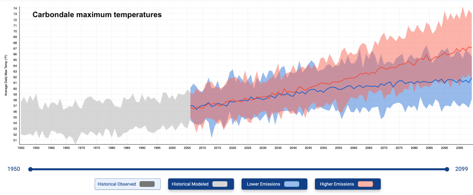
What does a 50% reduction look like over the course of the next 9 years? Think in terms of ski slopes, and not the dark blue of intermediates or even the ego-boosting single-black-diamond runs at Vail or Snowmass. Not even the mogul-laden Outhouse at Winter Park or Senior’s at Telluride.

Instead, think of the serious steeps of Silverton Mountain, where an avalanche beacon is de rigueur.

Can Colorado, a novice at carbon reduction, navigate down this Silverton Mountain-type carbon reduction slope by 2030?

Colorado, says EDF and Western Resource Advocates, needs a backstop, a more sweeping mechanism to ensure the state hits these carbon reduction goals.

California has had cap-and-trade for years, and a similar device has been used among New England states to nudge reductions from the power sector. The European Union also has cap-and-trade.

Following the May 2019 signing of Colorado’s carbon-reduction law, H.B. 19-1261, the Polis administration set out to create an emissions inventory, then began structuring a sector-by-sector approach. For example, the Air Quality Control Commission has conducted lengthy rule-making processes leading up to adoption of regulations in several areas.

Hydrofluorocarbons, a potent greenhouse gas used in refrigeration, are being tamped down. Emissions from the oil-and gas-sector are being squeezed. The commission this year will direct its attention to proposed rules that result in fewer emissions from transportation.

Meanwhile, the state has set out to hurry along the state’s electrical utilities from their coal-based foundations to renewables and a small amount of new gas. The utilities representing 99% of the state’s electrical sales have agreed to reduce emissions 80% by 2030 as compared to 2005 levels. Only one of those commitments, that of Xcel Energy, has the force of law. Others fall under the heading of clean energy plans. But state officials think that utilities likely will decarbonize electricity even more rapidly than their current commitments. That 80% is a bottom, not a top.

Will Toor, director of the Colorado Energy Office, presented to the Air Quality Control Commission an update on the state’s roadmap. The document released in mid-January runs 276 pages, but Toor boiled it down to 19 slides, which nonetheless took him 60 minutes to explain. It was a rich explanation.

Toor explained that Colorado needs to reduce emissions by 70 million tons annually. The Polis administration thinks it can achieve close to half of the reductions it needs to meet its 2030 target by 2030 through the retirement of coal plants and associated coal mines. Those reductions alone will yield 32.3 million tons annually.

The oil and gas sector should yield a reduction of 13 million tons, according to the state’s roadmap. That process had taken a step forward the previous day when the Air Quality Control Commission adopted regulations that tighten the requirements to minimize emissions from pneumatic controllers. Later this year, the AQCC will take up more proposed regulations.

Replacement of internal-combustion technology in transportation will yield 13 million tons. The Polis administration foresees deep reductions in transportation, partly through an incentives-based approach, even if not it’s not clear what all the components of the strategy look like.

Near-term actions in buildings, both residential and commercial, and in industrial fuel use can yield another 5 million tons annual reduction.

Waste reduction—methane from coal mines, landfills, sewage treatment plants, and improved recycling—will nick another 7.5 million tons annually More speculative are the strategies designed to reduce emission from natural and working lands by 1 million tons.

Add it all up and the state still doesn’t know how it will get all of the way to the 2030 target, let alone its 2050 goal of 90% reduction. Toor and other state officials, however, have expressed confidence that the roadmap can get Colorado far down the road to the decarbonization destination and is skeptical that cap-and-trade will.

“I would agree with the characterization that cap-and-trade guarantees emissions reductions,” said Toor. In the real world, he explains, those regimes struggle to achieve reductions particularly in sectors such as transportation where there are many decisions. The more demonstrable achievement has been in producing revenue to be used for reduction strategies.

“I don’t know that the record supports that they guarantee a true pathway toward reductions of emissions.”

In contrast, the roadmap has identified “highly enforceable strategies” to achieve reduction of 58 to 59 million of the 70 million tons needed by 2030, he said.

Some actions depend upon new legislation, perhaps this year and in succeeding years.

In the building sector, for example, the Polis administration sees “very interesting opportunities” with a bill being introduced into the legislature this year that would give gas-distribution companies targets in carbon reduction while working with their customers. See, “Colorado’s legislative climate & energy landscape.”

“This isn’t something that we are going to solve through just this year’s legislative session and this and next year’s regulatory actions,” said Toor. He cited many potential pathways, including hydrogen, but also, beyond 2030, the potential for cost-effective carbon capture and sequestration.

Later in the day, Pam Kiely and Thomas Bloomfield made the Environmental Defense Fund’s case for cap and trade. They described a more significant gap between known actions and the targets, a greater uncertainty about hitting the targets that they argued would best be addressed by giving power and other economic sectors allocation of allowances, which can then best be moved around to achieve reductions in cost-effective ways.

One example of cap-and-trade actually involves Colorado. The project is at Somerset, where several funding sources were pooled to pay for harnessing of methane emissions from the Elk Creek Mine to produce electricity. The Aspen Skiing Co. paid a premium for the electricity, and Holy Cross Energy added financial incentives. But a portion of the money that has gone to the developer, Vessels Coal Gas Co., is money from California’s cap-and-trade market

Kiely said Colorado’s 2019 law directed the Air Quality Control Commission to consider the greatest and most cost-effective emissions reductions available through program design. That, she said, was explicit authority for creating a cap-and-trade program.

“We think it’s a relatively light (legal) lift,” said Bloomfield. “You have authority to charge for those emissions.”

Further, Kiely said, cap-and-trade will most effectively achieve reductions in emissions and will do so faster than the state’s current approach. It will deliver a consistent economic signal and be the most adaptable. “The program does not have to predict where the optimal reduction opportunities will be a year from now without information about the relative cost of pollution control technologies, turnover rates in vehicles and other key uncertainties,” she said.

Then the questions came in. Kiely rebutted Toor’s charge of ineffectiveness. The most telling criticism of the California program was that the price was too low, she said.

What defeated the proposal—at least for now—were questions about its legality. Colorado’s Tabor limits revenues, and commission members were mostly of the opinion that their authority revenue-raising authority needed to be explored in depth.

Garry Kaufman, director of the Air Pollution Control Division, said that doing the work to rev up for a cap-and-trade program would require a “massive increase in the division’s staff,” north of 40 to 50 new employees, and the division does not have state funding.

He and others also contended that pursuing cap-and-trade would siphon work from the existing roadmap.

Then there was the sentiment that for a program of this size, the commission really did need direct legislative authority.

Commissioner Martha Rudolph said that in her prior position as director of environmental programs at the Colorado Department of Public Health & Environment, she had favored cap-and-trade. Not now, because of the legal, resource, and timing issues.

Elise Jones, the former Boulder County commissioner, voted no, but not without stressing the need to keep the conversation going, which is what will happen in a subcommittee meeting within the next few years.

“This is not now, not never,” said Rueter of the vote. This is conversation that will come up again, maybe at the federal level or maybe in Colorado a few years down the road.”

Wolf Creek #snowpack above average — The #PagosaSprings Sun #SanJuanRiver #ColoradoRiver #COriver #aridification

Upper San Juan River snowpack February 28, 2021 via the NRCS.

From The Pagosa Springs Sun (Clayton Chaney):

According to the U.S. Department of Agriculture National Water and Climate Center’s snowpack report, the Wolf Creek summit, at 11,000 feet of elevation, had 25.7 inches of snow water equivalent as of 2 p.m. on Feb. 24.

That amount is 109 percent of the Feb. 10 median for the site.

The average snow water equivalent for this date at the Wolf Creek summit is 23.5 inches.

San Miguel, Dolores, Animas, and San Juan Basin High/Low graph February 26, 2021 via the NRCS.

The San Miguel, Dolores, Animas and San Juan River Basins were at 85 percent of the Feb. 24 median in terms of snowpack…

River report

According to the U.S. Geological Survey (USGS), the San Juan River was flowing at a rate of 49.4 cfs in Pagosa Springs as of 2 p.m. on Wednesday, Feb. 24.

Based on 85 years of water re- cords at this site, the average flow rate for this date is 73 cfs.

The highest recorded rate for this date was in 1995 at 269 cfs. The lowest recored rate was 28 cfs recorded in 1961.

The Pagosa Area Water & Sanitation District plans for early season #drought mitigation — The #PagosaSprings Sun #ColoradoRiver #COriver #aridification #SanJuanRiver

West Drought Monitor February 23, 2021.

From The Pagosa Springs Sun (Simone Mouseamy):

At its meeting on Feb. 11, the Pagosa Area Water and Sanitation District (PAWSD) Board of Directors nailed down its drought management system.

PAWSD Manager Justin Ramsey went over the trigger points in place for establishing drought stages.

Ramsey said, “The way we’re going now is based upon a couple different trigger points, and it’s also based on the date that the trigger point hit. For example, if Hatcher is down 6 feet and if it’s in late September, no big deal; if it’s in early May we’ve probably got problems coming. So, this way it kind of helps us see what’s coming on.”

He continued, “Later on, in the summer, then we’ll start looking at three other issues: the amount of water in the Hatcher reservoir, the amount of water that’s going down the San Juan River and the state’s drought statement.”

PAWSD Treasurer Glenn Walsh voiced a concern.

“The two triggers early in the season, the call date and the snow water [equivalent] … those just need to be aligned better. If we’re operating off hitting both triggers, then I have less concern. But if we’re operating off hitting one of the two triggers, for instance the call date in 2018 was 4/11, and if we had a 2018-type year, I wouldn’t be comfortable with just starting the year full-blown stage 4 — ‘your lawns are going to die’ — because my impression was 2018 was not that type of year … Even though we do have two indicators that we use up until June 1 and then three that we use after June 1, it would be good if those were aligned so there’s not some discordance where we’re in level 4 then when we turn over to the river and lake level and the regional drought declaration we’re back to level 1 — you know? We’re jumping back and forth,” he said.

“I guess my question is we’re going to trigger the early season stages by one of the two measures, or are we going to go with the least restrictive? … If we’re only going by one trigger, that could wind up being kind of a false alarm,” Walsh said.

Ramsey responded, “Yes and no … They typically do fall fairly close together. … I don’t know how often they do a call before we run out of snow — it’s usually within a week. … Just because the trigger says to do that, if there’s a reason for the board to say, ‘Let’s not do it because of x, y, or z,’we call it. It just gives us a starting point … To go to stage 1, 2, 3, 4 takes a board decision; it doesn’t just do it automatically.”

[…]

At the meeting, Ramsey mentioned that entering a voluntary level 1 or level 2 drought stage in the early season might help to eliminate the chances of reaching level 3 or level 4 later in the season by means of alerting the public to be conservative with their water usage.

“The way we’re moving now, we’re probably going to go at a voluntary level 1, level 2 a little earlier than we have historically. We are not going to charge a surcharge to throw you into level 3 or level 4. When we get into level 2, there will be an increase in excess water use in residential, and when we get to level 3 there will be an excess water use in commercial. But, there will be no surcharge until we get to level 3 and level 4,” notified Ramsey.

He added, “The way I calculated the surcharge was … for every drought stage we have it goes to a decrease on one use by x percentage, so I just assume that we decreased our water use by x percentage, which means that we decreased our income by x percentage, and I’m making it up with that.”

He continued, “The hope is by going into drought mitigation level 1, level 2 voluntary, early … the only way to get to that surcharge is if we were in great dire straits.”

#Snowpack news (February 27, 2021): Nice bumps from the storminess, most basin’s percent of normal is hanging around the low end of the normal range

Click on a thumbnail graphic to view a gallery of snowpack data from the NRCS.

Here’s the Westwide Snotel basin-filled map for February 28, 2021 from the NRCS.

Westwide SNOTEL basin-filled map February 28, 2021 via the NRCS.

Report: Estimates of future Upper #ColoradoRiver Basin water use confound planning: “In other words, if the water physically is not there anymore, it doesn’t really matter what the compact says the upper basin is entitled to” — Heather Sackett, @AspenJournalism #COriver #aridification

#LakePowell is seen in a November 2019 aerial photo from the nonprofit EcoFlight. Keeping enough water in the reservoir to support downstream users in Arizona, Nevada and California is complicated by climate change, as well as projections that the upper basin states of Colorado, Utah, Wyoming and New Mexico will use as much as 40% more water than current demand. A recent white paper from a lineup of river experts calls those use projections into question. CREDIT: ECOFLIGHT via Aspen Journalism

From Aspen Journalism (Heather Sackett):

Paper’s authors say unrealistic projections make it harder to plan for a future under climate change

Some water experts fear that a long-held aspiration to develop more water in the Upper Colorado River Basin is creating another chance to let politics and not science lead the way on river management.

“Alternative Management Paradigms for the Future of the Colorado and Green Rivers,” a white paper released this month by the Center for Colorado River Studies, says that in order to sustainably manage the river in the face of climate change, we need alternative management paradigms and a different way of thinking compared with the status quo.

Estimates about how much water the upper basin will use in the future are a problem that needs rethinking, according to the paper.

The paper says unrealistic future water-use projections for the upper basin — Colorado, Utah, Wyoming and New Mexico — confound planning because they predict the region will use more water than it actually will. The Upper Colorado River Commission’s estimates for future growth are unlikely to be realized and are perhaps implausible, unreasonable and unjustified, the paper says.

“The projection of demand is always higher than what is actually used,” said Jack Schmidt, one of the paper’s authors and the Lawson Chair in Colorado River Studies at Utah State University. “We said you can’t plan the future of the river based on these aspirational use projections when there’s a clear demonstration that we never end up using as much as we aspire to use.”

The Center for Colorado River Studies is affiliated with Utah State but draws on expertise from throughout the basin. The paper is the sixth in a series of white papers that is part of The Future of the Colorado River Project. The project is being funded by multiple donors, including the Walton Family Foundation, the USGS Southwest Climate Adaptation Science Center, the Utah Water Research Laboratory and two private donors, as well as by grants from the Catena Foundation, which is a major donor to Aspen Journalism’s water desk.

According to the paper, between 1988 and 2018 consumptive water use in the upper basin has remained flat at an average of 4.4 million acre-feet a year. This figure is based on the Bureau of Reclamation’s Consumptive Uses and Losses reports. The UCRC’s most recent numbers from 2016 show future water use in the upper basin — known as a “depletion demand schedule” — at 5.27 million acre-feet by 2020 and 5.94 million acre-feet by 2060.

“In percentage terms, these UCRC projections for 2020 are already 23% higher than actual use and would be more than 40% higher than present use in 2060,” the paper reads.

And future water use is unlikely to increase because of three main reasons: thirsty coal-fired power plants are on their way to being decommissioned; land that was formerly used for irrigated agriculture is transitioning to residential developments, which use less water; and there are regulatory and political barriers to more large transmountain diversions from the headwaters of the river to the Front Range.

The white paper’s authors say these unrealistic future projections of water use make it harder to plan for a water-short future under climate change.

“Unreasonable and unjustified estimations create the impression that compact delivery violations, very low Lake Powell and Lake Mead storage content and greater Lower Basin shortages are inevitable,” the paper reads. “Such distortions mislead the public about the magnitude of the impending water supply crisis and make identifying solutions to an already difficult problem even harder.”

The issue is twofold: With climate change, there is not enough water for the upper basin to develop new projects without the risk of a compact call; and if the past three decades are any indication, the upper basin is not on track to use more water in the future anyway.

So why might the UCRC be overestimating future water use? To understand that, one must take a closer look at the Colorado River Compact.

Urban development along Colorado’s Front Range is seen in an aerial photo from the nonprofit EcoFlight. A commission representing states comprising the upper basin of the Colorado River estimates as much as 40% higher water use compared to current levels by 2060, but a recent white paper calls those assumptions into question as says they hamper efforts to realistically deal with climate change.
CREDIT: ECOFLIGHT via Aspen Journalism

The law of the river

In 1922, the framers of the Colorado River Compact divided the waters of the river, giving the upper basin and the lower basin — California, Nevada and Arizona — 7.5 million acre-feet each. This amount, known as an apportionment or “entitlement,” was thought to be fair at the time because it gave the slow-growing upper basin time to develop their share of the water without the faster-growing lower basin claiming it first.

The mission of the UCRC is to protect the upper basin’s ability to use its share of the river. And this entitlement is symbolic of the upper basin’s dreams and aspirations: growing cities and towns and thriving agricultural communities.

The problem is that the century-old agreement didn’t account for dwindling flows caused by climate change. Studies have found — under what Brad Udall, one of the paper’s authors and a climate and water researcher at Colorado State University, calls “the new abnormal” — that runoff decreases as temperatures rise.

Compounding the issue is that under the compact, the upper basin is still required to deliver the same amount of water to the lower basin regardless of declining flows.

“The reason we entered into a compact was because we knew we couldn’t develop as quickly as the lower basin, so the whole idea is that we could develop later,” said Jennifer Gimbel, former director of the Colorado Water Conservation Board and interim director at the CSU Water Center. “But as we know, streamflow is not as strong and climate change is cutting into it even more and more, and that puts you into a conundrum.”

The result is that there are 15 million acre-feet of entitlements on paper, not including Mexico’s share, but just 12 million to 13 million acre-feet of water. And that number is likely to decline even further as temperatures rise. Soon, there may not be enough water for the upper basin to meet its compact obligations to the lower basin and to develop new water projects.

“You cannot have a situation where climate change is reducing the yield of the basin and everyone is sticking to what they think their entitlements are under the compact,” said Eric Kuhn, one of the study’s authors. “Something has to give.”

In other words, if the water physically is not there anymore, it doesn’t really matter what the compact says the upper basin is entitled to.

Kuhn is the former general manager of the Colorado River Water Conservation District and also co-author of the 2019 book “Science Be Dammed: How Ignoring Inconvenient Science Drained the Colorado River.” One of the book’s main points is that past Colorado River decision-makers let politics and competition for a limited supply of water — not science — be the main drivers of river management. Because of that, the river was over-allocated from the beginning. Kuhn worries that this trend may be continuing.

“The fear is that this is another opportunity to ignore the science,” he said. “Forget about these projections that show how much water we might have been able to develop 40 years ago and focus on the river that nature has given us with climate change and not the one we wish we had from decades ago.”

Members of the Colorado River Commission, in Santa Fe in 1922, after signing the Colorado River Compact. From left, W. S. Norviel (Arizona), Delph E. Carpenter (Colorado), Herbert Hoover (Secretary of Commerce and Chairman of Commission), R. E. Caldwell (Utah), Clarence C. Stetson (Executive Secretary of Commission), Stephen B. Davis, Jr. (New Mexico), Frank C. Emerson (Wyoming), W. F. McClure (California), and James G. Scrugham (Nevada)
CREDIT: COLORADO STATE UNIVERSITY WATER RESOURCES ARCHIVE via Aspen Journalism

Interstate poker game

The upper basin, including Colorado, is currently exploring the concept of a demand-management program, which could reduce water use by paying irrigators to not irrigate. The goal of the program, which would be temporary and voluntary for participants, would be to send as much as 500,000 acre-feet of water to Lake Powell to prop up levels and avoid a compact call.

A compact call could occur if the upper-basin states can’t deliver the 7.5 million acre-feet of water per year to the lower-basin states as required by the compact. This could trigger an interstate legal quagmire, a scenario that water managers desperately want to avoid.

If it appears contradictory that the upper basin is looking at how to reduce water use while at the same time clinging to a plan for more future water use, that’s because it is.

Water attorney Peter Fleming said some are asking why the upper basin is planning to reduce existing depletions while also planning an additional million acre-feet of depletions. Fleming is general counsel for the River District. He also is on the legal committee for the UCRC, but is not speaking on behalf of that organization here. “It seems the upper basin as a whole needs to reconcile that seeming contradiction,” he said.

Some water experts compared the UCRC’s depletion schedule to an interstate chess or poker game, complete with bluffing. The upper basin must insist it will one day put to beneficial use all of its unused share — or else the lower basin, which already uses all of its own share, could somehow claim the unused portion.

“There’s still this fear that if we don’t use our water, the lower basin will establish an economic use and economic reliance on that water, and it will be very difficult to get it back in the future, even though we are entitled to it,” Kuhn said. “The downside to that right now is the water is just not there.”

Lake Powell is seen in a November 2019 aerial photo from the nonprofit EcoFlight. Keeping enough water in the reservoir to support downstream users in Arizona, Nevada and California is complicated by climate change, as well as projections that the upper basin states of Colorado, Utah, Wyoming and New Mexico will use as much as 40% more water than current demand. A recent white paper from a lineup of river experts calls those use projections into question.
CREDIT: ECOFLIGHT via Aspen Journalism

UCRC Director Amy Haas said in an email that although the paper is thought-provoking, the authors base their analysis on an obsolete projection of future Upper Basin water use demands from 2007 instead of relying on the current 2016 projections, which show a decrease in future demand as well as a slower rate of projected future demand. She said the authors did not consult the commission on the paper before its release.

Study authors have said that current data from the Bureau of Reclamation wasn’t released in time for the 2016 numbers to be used in the paper, and that they used the most up-to-date information available to them. They also say the differences between the two sets of numbers are minor and don’t change their findings.

Diversity, Equity, and Inclusion in the Colorado Water Plan Update — @WaterEdCO

What we are working to protect. Culebra-Gallegos maíz de concho grown at Acequia Institute farm in Viejo San Acacio. Photograph by Devon G. Peña

From Water Education Colorado (Willow Cozzens, Samantha Grant, Amelia Nill, and Andrew Primo):

Effective agricultural water planning is critical for a sustainable and resilient future in Colorado. Not only does the agricultural sector account for 86.7% of the state’s consumed water, but agriculture is also the crucial economic and cultural foundation for many communities. The 2015 Colorado Water Plan (CWP), a statewide roadmap for water management, is currently undergoing a multi-year update that includes new information, critical action items, and revised water planning schemes for all sectors. This update will be published in 2022. In order to foster lasting resilience, the CWP update must be more inclusive of all Coloradoans and provide comprehensive planning for historically underserved communities across the state.

True sustainability can not be divorced from empowering all communities. Studies show that systems with many sources of knowledge are generally more resilient. Just as farmers often plant several different crops to prepare for potential vulnerabilities, water planning must strive to be as diverse as possible to create a water resilient future.

Who has been excluded from agricultural water planning?

Colorado has an exciting opportunity to be more inclusive in water planning and subsequently create a truly sustainable CWP. But first, underserved groups must be identified throughout all sectors. This will necessitate nuanced outreach and calls to action. Three groups who have been historically excluded from Colorado water planning in agriculture are:

In southern Colorado’s San Luis Valley, Judy Lopez with Colorado Open Lands and landowner Dave Marquez discuss upcoming restoration work on the Culebra River, which
traverses his property. Marquez irrigates from the Francisco Sanchez Acequia to grow alfalfa-grass hay. The acequia worked with Colorado Open Lands and the bylaws project to develop bylaws that preserve their oral traditions. Photo by Christi Bode
  • People who operate under acequia management systems. For communities in Colorado and northern New Mexico, an acequia is a physical system, an irrigation ditch, but it is also a deeply embedded philosophy of community and governance. These producers are primarily Hispanic or Latinx and reside in the San Luis Valley within the Rio Grande River Basin or in the Arkansas River Basin. The term “acequia” is mentioned only once in the entire 2015 CWP — in a footnote of a farmer profile.
  • Many Indian reservations are located in or near contentious river basins where demand for water outstrips supply. Map courtesy of the Bureau of Reclamation.
  • Tribal water users. Two federally recognized tribes have designated land reservations within the borders of Colorado: the Southern Ute Indian Tribe (SUIT) and the Ute Mountain Ute Tribe (UMUT). While it must be acknowledged that 48 contemporary tribal nations are historically tied to the lands that make up Colorado, the Ute tribes are holders of federal reserved water rights in the state. Both the SUIT and UMUT tribal reservations are located within the Southwest Basin (e.g. San Juan/Dolores), though the UMUT reservation also includes land in New Mexico and Utah. While the tribes have become more frequent partners in broader interstate negotiations, inclusion at the intrastate level is still limited to the Southwest Basin Roundtable. Given the Ute tribes’ status as the state’s original water users and the unique nature of their federally reserved rights, more efforts should be made to explicitly include tribal representatives in deliberative processes.
  • Hanging Oyster mushroom columns growing on waste coffeegrounds via Gro Cycle
  • Urban agricultural producers. Urban agriculture in Colorado may include a variety of production methods and water uses, such as community gardens, hydroponic growing facilities, small-scale market farms, and more. It is important to note that there is not necessarily the same rich history or record of exclusion for urban agriculture as the above two groups. Rather, planning for water in urban agriculture could present an exciting opportunity to foster resilience in the food system and land use planning for the future of Colorado. Before defining demographics and practices within urban agriculture, a standard definition of urban agriculture in Colorado must be implemented.
  • Tribes are acknowledged in the Southwest Basin Implementation Plan, and acequias are acknowledged in the Rio Grande Basin Implementation Plan. Urban agriculture is not mentioned in the 2015 CWP or in any of the Basin Implementation Plans (BIPs). The BIPs could serve as an opportunity to elevate underserved voices, given their regional focus, and create a space for them at the state level. An equitable and just water planning process at all levels, from local to basin to state, is critical for Colorado’s present and future water needs.

    Paving the way toward more inclusivity in Colorado water planning

    The Department of Natural Resources has recently announced the formation of a water equity committee, which is set to include representatives from each river basin and each tribal nation. Within this engagement process, Colorado water planners must make the effort to explicitly solicit input and feedback from underserved individuals and groups in agriculture and all other water sectors. Outreach efforts must be nuanced for each community, each conversation, and each stage in inclusive planning. Overall, CWCB should focus on elevating voices of change makers within historically underserved communities and solicit consistent feedback for a more inclusive, equitable, and holistic Colorado Water Plan.

    This strategy should aim to advance diverse representation in natural resource planning and provide opportunities for more equitable funding. Explicit inclusion via community outreach may also encourage diversity in water planning schemes, which can in turn create a more sustainable future. The equity committee and the CWCB should reach out to representatives of underserved communities and facilitate dynamic and interactive working sessions where stakeholders can discuss water challenges and opportunities with the CWCB.

    In partnership with CWCB and the University of Colorado – Boulder, we conducted an initial working session with a goal of establishing a more inclusive dialogue for producers. This work session, which focused on water issues among urban agriculture producers, will be discussed in a later blog post.

    Ideally, such facilitated dialogues will lead to additional working sessions, inclusion in water planning procedures at the state level, participation in Basin Roundtables, submission of public comments, and general advocacy pointed toward agricultural water planning. This approach may foster a more diverse, equitable, and inclusive 2022 Colorado Water Plan, and a better water planning process into the future.

    “The figures offer a reality check on the many promises coming from world capitals and company boardrooms that leaders are taking climate change seriously” — Somini Sengupta, The New York Times

    Cars pass the Shanghai Waigaoqiao Power Generator Company coal power plant in Shanghai on March 22, 2016. – Environmental watchdog Greenpeace warned on March 22, 2019 the world’s coal plants are “deepening” the global water crisis as the water consumed by them can meet the basic needs of one billion people. China, the world’s largest emitter, has promised to reach zero net carbon emissions by 2060. (Photo by JOHANNES EISELE / AFP) via Voice of America

    From The New York Times (Somini Sengupta):

    New climate pledges submitted to the United Nations would reduce greenhouse gas emissions by less than 1 percent, the world body announced.

    The global scientific consensus is clear: Emissions of planet-warming gases must be cut by nearly half by 2030 if the world is to have a good shot at averting the worst climate catastrophes.

    The global political response has been underwhelming so far.

    New climate targets submitted by countries to the United Nations would reduce emissions by less than 1 percent, according to the latest tally, made public Friday by the world body.

    The head of the United Nations climate agency, Patricia Espinosa, said the figures compiled by her office showed that “current levels of climate ambition are very far from putting us on a pathway that will meet our Paris Agreement goals.”

    The figures offer a reality check on the many promises coming from world capitals and company boardrooms that leaders are taking climate change seriously…

    Some of the biggest emitter countries — including Australia, Brazil and Russia — submitted new plans for 2030 without increasing their ambitions. Mexico lowered its climate targets, which the Natural Resources Defense Council described as a signal that “Mexico is effectively retreating from its previous leadership on climate and clean energy.”

    In contrast, 36 countries — among them Britain, Chile, Kenya, Nepal and the 27 countries of the European Union — raised their climate targets.

    The Paris Agreement is designed in such a way that the United Nations can neither dictate nor enforce any country’s climate targets, or what are called nationally determined contributions. Each country is expected to set its own, make regular reports to the world on its progress and set new targets every five years. Diplomatic peer pressure is meant to persuade each country to be more ambitious.

    The end goal is to limit global temperature increase to within 1.5 degrees Celsius of 1990 levels. Any warming beyond that, scientists have said in exhaustive studies, would risk widening wildfires and droughts, growing food and water insecurity, and the inundation of coastal cities and small islands.

    #Colorado Water Plan Update Is Underway — @AudubonRockies

    > Great Blue Herons. Photo: Pamela Underhill Karaz/Audubon Photography Awards

    From Audubon Rockies (Abby Burk):

    Help define this moment for birds, rivers, and people.

    What memories can you recall from five years ago? Well, you may remember that Colorado’s inaugural Water Plan had just been finalized in November of 2015. The Audubon network, our partners, and Coloradans were key in defining the plan. Five years of plan implementation have flown by. As the plan moves forward in its first update, what have we learned to set the course for necessary immediate and long-term steps to ensure water security for people and the environment? We need your statewide engagement, again.

    The Water Plan in Short

    Colorado’s Water Plan 2015 is a framework pointing the way toward safeguarding Colorado’s water values as population, water variability, and drought increase. Colorado’s water values are supporting healthy watersheds and the environment, robust recreation and tourism economies, vibrant and sustainable cities, and viable and productive agriculture.

    The plan’s foundation stands on work by Colorado’s nine basin roundtables and their basin implementation plans, the Interbasin Compact Committee, the Colorado Water Conservation Board (CWCB), partners, and stakeholders statewide. The collaboration that fueled the Colorado Water Plan sparked the state’s largest civic engagement and the CWCB received more than 30,000 public comments on priorities and direction for the plan. Audubon’s network provided nearly 20 percent of general comments received, and Audubon staff provided consented technical environmental resilience and stream ecology language. The top-two categories of all public comments received were support for healthy rivers and better use of water in cities and towns. The unprecedented public engagement truly produced Colorado’s Water Plan.

    Without a strong plan and funding for implementation, Colorado’s birds, rivers, and people will face a problematic future with unacceptable consequences.

    Why Update Now?

    Colorado is changing and the Colorado Water Plan must be responsive. Our population is over 5.7 million today and could nearly double by 2060. With climate change increasing temperatures and making water supply less predictable, rivers are already stretched thin. Within the next few decades, even assuming aggressive water conservation and the completion of dozens of water projects currently being considered, the state could face a shortfall that exceeds 500,000 acre-feet annually.

    The plan update will complete in 2022 and map Colorado water resource management for the next seven years. As a headwaters state, the value of Colorado’s rivers flows far beyond its boundaries. Healthy, flowing rivers support all water uses and users—both wildlife and people. Protecting rivers protects our economy, our birds, and our way of life, but their future is uncertain. Audubon was closely involved in the creation of the plan and currently is involved in its implementation. Now, five years later, we’re helping to update the plan.

    (Abby Burk and other experts explain how Colorado can best update the Colorado Water Plan.)

    How to Engage

    Audubon is committed to protecting the health of Colorado’s rivers, ecosystems, and sustainable water supplies—values that benefit everyone. We are working across water interests to show that water connects rather than separates us. Together, we can protect Colorado’s incredible rivers and the birds that depend upon them. Public input on the Colorado Water Plan update will be critical. Here’s how you can participate:

    Engage in Your Local Basin

    Each of Colorado’s nine basin roundtables has been updating their local water supply and management plans called basin implementation plans (BIPs). Updated BIPs will soon be ready for public review. Click on your basin here to find your basin roundtable website, then click through to the BIP update status. Updated BIPs are getting ready to roll out soon. Also, due to COVID-19 concerns, basin roundtables have been meeting virtually. If you have not already, you can attend a virtual basin roundtable meeting to get to know your basin’s scope of work and your basin’s hardworking volunteers leading local water management efforts.

    Engage on the State Plan

    Everyone needs healthy rivers. Our hope is that this plan update will represent not only the human needs, but also a healthy ecosystem on which we and our wildlife depend. Currently, the Colorado Water Conservation Board is collecting survey feedback on the direction for the Colorado Water Plan update. Staff and stakeholder input has informed the current thinking, which is summarized in five informational sheets: Water Plan Update Vision, Vibrant Communities, Robust Agriculture, Thriving Watersheds, and Resilient Planning. Please review the information sheets and fill out the survey here.

    Audubon Rockies will be asking for local involvement through comments on the basin implementation plans and the statewide plan, so be on the lookout for more timely ways you can engage!

    New Technology Helps Ranchers Maximize Grass Production — NRCS

    Photo credit: NRCS

    Here’s the release from the NRCS (Brianna Randall):

    One out of every three acres in the U.S. is rangeland. Two-thirds of these are privately owned, mainly by ranchers who graze their livestock in the open country of the American West.

    Our rangelands produce premium beef, wool, and dairy. But it’s the plants that feed these livestock that are the foundation for profitable agriculture in the West.

    But ranchers haven’t had a good way to measure how their grass is faring — until now.

    The Rangeland Analysis Platform (RAP), developed in partnership with the USDA Natural Resources Conservation Service, Bureau of Land Management, and the University of Montana, allows producers to track changes in the amount and types of plants growing on their property.

    RAP is a free online resource that provides data on vegetation trends across the West from the mid-1980s to the present; and it calculates how productive those plants are. A combination of long-term datasets shows landowners how their lands have changed over time, which translates directly into their operation’s profitability.

    “We can finally quantify outcomes of rangeland conservation in terms of dollars and cents,” says Tim Griffiths, western coordinator for NRCS’s Working Lands for Wildlife.

    Graphic credit: NRCS

    Closing the gap to boost grass growth

    Farmers in the central and eastern U.S. have been using technology to track changes in crop production for decades. As soon as they see that their plant productivity is declining — and revenues following suit — they can take steps to address the limitations and boost productivity again.

    RAP provides the same power to ranchers.

    Graphic credit: NRCS

    RAP can show ranchers the gap between their potential production and the actual production they realize in terms of pounds-per-acre of grass. It helps landowners understand how much they can potentially gain by changing management practices to boost available forage and close the gap.

    Landowners can see how their plant production has changed in a single month or over the span of several years. The technology can be used to visualize plant productivity in an area as small as a baseball diamond or as large as several states.

    “Basically, RAP can prevent lost revenues by showing producers where their land is less effective at growing grass. It helps ranchers put the right practices in the right places,” says Brady Allred, a University of Montana researcher who helped develop RAP.

    Preventing trees from robbing ranchers

    Photo credit: NRCS

    One of the main threats to production and profitability on western rangelands is the expansion of trees onto grasslands. From eastern redcedar destroying tallgrass prairie to juniper marching across sagebrush grazing lands, woody species are costing producers millions of dollars in lost forage.

    For example, the now-forested property in Nebraska pictured here produced zero pounds/acre of grass in 2014. But in 1985, RAP reveals that same property produced 2,200 pounds/acre of grass — before eastern redcedar consumed the once-fertile prairie.

    “Last year, we quantified that western rangelands missed out on tens of billions of pounds of forage due to trees taking over prairies and shrub lands since 1990,” says Dirac Twidwell, rangeland ecologist at the University of Nebraska and science advisor for NRCS Working Lands for Wildlife.

    This yield gap, says Twidwell is “costing producers hundreds of millions in lost revenue each year.”

    Take the Flint Hills of Kansas, America’s most productive grasslands and the fourth-largest intact prairie left in the world. In 2019, RAP shows that this region produced 21.3 billion pounds of forage.

    But RAP also shows that ranchers in the Flint Hills lost another billion pounds of forage in 2019 due to encroaching trees. That adds up to nearly 800,000 round-bales of hay lost last year.

    Put in terms of dollars, those unwanted trees cost Kansas producers $8.3 million in lost revenue in a single year.

    Graphic credit: NRCS

    Stemming the tide of trees with technology

    Using RAP’s satellite imagery, ranchers across Nebraska are burning seeds and saplings before they become trees; and in Kansas, ranchers are using RAP to cut trees across ownership boundaries to restore prime grass grazing lands.

    New technology like RAP helps us “help the land” in order to sustain wildlife, provide food and fiber, and support agricultural families long into the future.

    Flooding events a major concern for Grand County following #EastTroublesomFire — The Sky-Hi Daily News #ColoradoRiver #COriver #aridification

    The map above displays estimates of the likelihood of debris flow (in %), potential volume of debris flow (in m3), and combined relative debris flow hazard. These predictions are made at the scale of the drainage basin, and at the scale of the individual stream segment. Estimates of probability, volume, and combined hazard are based upon a design storm with a peak 15-minute rainfall intensity of 24 millimeters per hour (mm/h). Predictions may be viewed interactively by clicking on the button at the top right corner of the map displayed above. Map credit: USGS

    From The Sky-Hi Daily News (Amy Golden):

    One of the biggest concerns following the East Troublesome Fire in Grand County is flooding risk, specifically flooding that picks up debris to create mudflows. Local and national officials are working to get the word out about this new risk and prepare Grand County for a changed landscape this summer…

    A number of watersheds were burned in the East Troublesome Fire, including 94% of the Willow Creek Watershed, 90% of the Stillwater Creek Watershed, 42% of the North Inlet Watershed and 29% of the Colorado River Watershed.

    Projections have found that water flow from snowmelt and weather events on the burn scar could be 14 times higher than before. According to Grand County Emergency Manager Joel Cochran, the National Weather Service will be monitoring rainstorms that produce even a little bit of rain…

    The US Geological Survey has also produced preliminary hazard assessment across the East Troublesome burn scar. The assessment found that most of the water basins in the burn scar present a moderate risk of debris flow hazards with a high risk in certain areas.

    County officials have been working to identify specific risks to property and life.

    The first part of that included field surveys for damage assessments, which were completed last week. Using additional modeling, risk for various structures have been further assessed and officials are working to communicate that hazard to land owners.

    In her Tuesday update to commissioners, Grand County Water Quality Specialist Katherine Morris added that some narrow canyons and roads near flowing water would likely need formal evacuation plans.

    #Colorado Water Plan Scoping Workshop: Agriculture Irrigation Infrastructure — @CWCB_DNR, @DARCAonline, Ag Water Alliance

    The Ella Ditch, which irrigates agricultural land south of Carbondale, placed a call on the Crystal River for the first time ever in 2018. Photo credit: Brent Gardner-Smith/Aspen Journalism

    Click here for all the inside skinny and to register.

    Join a roundtable discussion focusing on agricultural irrigation infrastructure issues and solutions to inform the 2022 Colorado Water Plan.

    The Colorado Water Conservation Board, in partnership with the Colorado Agricultural Water Alliance and Ditch and Reservoir Company Alliance, invites you to participate in a virtual, Colorado Water Plan Update Scoping Workshop focusing on agricultural irrigation infrastructure issues and solutions. The format of the workshop will be an expert roundtable discussion that will inform the scoping process of the Colorado Water Plan Update (more information here: https://engagecwcb.org/colorado-water-plan-update).

    The Colorado Water Plan provides a roadmap for addressing water resource challenges; informing strategies, policy development, and programming. The event will be open to the public.

    More than 25 million drink from the worst US #water systems, with Latinos most exposed — The Guardian

    The water treatment process

    Here’s an in-depth report from Emily Holden, Caty Enders, Niko Kommenda, and Vivian Ho that’s running in The Guardian. Click through and read the whole article and to check out the story map detailing the problem. Here’s an excerpt:

    Millions of people in the US are drinking water that fails to meet federal health standards, including by violating limits for dangerous contaminants.

    Latinos are disproportionately exposed, according to the Guardian’s review of more than 140,000 public water systems across the US and county-level demographic data.

    Water systems in counties that are 25% or more Latino are violating drinking water contamination rules at twice the rate of those in the rest of the country.

    America’s worst public water systems – those that have accrued more than 15 “violation points” for breaking standards over five years – serve more than 25m Americans, the research shows. An estimated 5.8m of these are Latino.

    Texas, where millions of residents lost access to water and power during the recent storm, has the most high-violation systems, followed by California and Oklahoma. The average number of violations is highest in Oklahoma, West Virginia and New Mexico.

    The six-month investigation of five years of Environmental Protection Agency (EPA) and other data also shows how:

  • Access to clean drinking water is highly unequal in the US, based on race, income and geography
  • Poorer counties have more than twice as many violation points as wealthy ones
  • Some water systems report hundreds of violation points year after year without any action from the government and without being required to notify customers
  • Rural counties have 28% more violation points than metropolitan ones
  • Scientists and former government officials describe a water regulation system that is broken. “Most policymakers believe compliance with environmental rules is high,” said Cynthia Giles, the former head of enforcement at the EPA under Barack Obama, but that belief was “wrong”.

    Experts are most concerned about systems serving smaller communities. They say Latinos are particularly at risk because they often live near industrial farms in California and the west that have polluted local water with nitrates in runoff from fertilizers and manure. They are also more likely to live in the south-west, where arsenic violations are common.

    2021 #COleg: #Colorado House panel debates making pumped hydro a #renewable energy source — The #GrandJunction Daily Sentinel (HB21-1052 Define Pumped Hydroelectricity As Renewable Energy)

    Pumped hydroelectric generation illustrated. Graphic via The Mountain Town News

    From The Grand Junction Daily Sentinel (Charles Ashby):

    The leading Republican in the Colorado House says it’s about time that pumped hydroelectric power plants are considered recycled energy that counts under the state’s renewable energy standard.

    One of the reasons why it isn’t already counted as a renewable energy is because, unlike conventional hydroelectric power plants, pumped hydro requires additional power to move water uphill to an upper reservoir so that it can flow downhill to a lower reservoir through a turbine to generate electricity.

    House Minority Leader Hugh McKean, R-Loveland, told the House Energy & Environment Committee on Wednesday the technology now exists to do that either with traditional renewable energy or at least to make it all work carbon neutral…

    McKean said that most pumped hydroelectric plants don’t generate nearly as much electricity as those fossil fuel plants, but they often are used to help keep power costs to consumers down during peak usage times.

    The beauty of them is they can augment power during peak times when costs are higher, thus reducing those costs, and use less expensive electricity to pump the water back uphill during non-peak times, such as late at night, he said…

    McKean also said the pumped hydroelectric plants don’t require a lot of energy to pump that water uphill, adding that it can be done in a number of ways, including through stored power from solar, wind or rechargeable batteries.

    The measure, HB21-1052, which the committee discussed but hasn’t yet voted on, has support from several rural electric associations, the Colorado Farm Bureau and some environmental groups, such as Trout Unlimited, but only if the bill is amended to ensure guardrails are in place to protect aquatic life from being harmed, something McKean said he plans to do…

    Currently, there are only five hydroelectric pump storage stations operating in the state, all of which are located on the Front Range or Eastern Plains, according to a database maintained by the U.S. Energy Information Administration.

    That agency also lists 64 conventional hydroelectric plants operating in Colorado, including many on the Western Slope.

    February 2021 #Drought Update — @ColoradoDNR

    Click here to read the update (Megan Holcomb & Tracy Kosloff):

    Drought conditions in Colorado continue as we reach our ninth straight month of above-average temperatures combined with eleven months of below-average precipitation. The state experienced the 15th warmest October-January on record and noted an overall increased temperature of 2.5°F above Colorado’s 20th century average. Despite the cold weather in mid-February, the month has shown warmer temperatures west of the divide and record-breaking low temperatures to the east. Holyoke reached their 5th coldest temperature on record at -30°F and Lamar recorded their 3rd coldest temperature at -27°F on the 15th of February.

    Colorado Drought Monitor February 23, 2021.

    The U.S. Drought Monitor from February 11th recorded exceptional (D4) drought conditions across 25% of the state, which dropped to 18% on the February 18th monitor. Extreme (D3) drought covers 41% of the state; severe (D2) drought covers 30%; and moderate (D1) drought covers 10%.

    The 90-day Standardized Precipitation Index (SPI) values from Nov 16 to Feb 13 highlight the northern mountains and central northern areas of the state in dry conditions. Eastern Colorado reflects select areas of above average precipitation after recent January snowstorms. However, the 12-month SPI map provides more accurate depictions of the 2020 deficits across the state.

    Through January statewide snowpack was 65% of normal. After a few February storms, statewide snowpack rose to 88% of normal as of Feb. 25th. State reservoir storage is currently at 83% of average. Extreme soil moisture deficits and below normal precipitation means all basins should prepare for a low runoff year. The continuance of drought is expected through 2021 and the State Drought Plan remains in Phase 3 activation.

    Water providers report slightly below average storage levels and near normal winter demands. Drought management planning and potential restrictions are being discussed through multiple coordinated groups. In January, over 120 water providers completed a CWCB needs survey to inform statewide drought coordination and near-term Municipal Water Task Force efforts.

    @NASA Snow Campaign Digs Deep in 2021 #snowpack #runoff

    Measuring snow might seem straightforward, but each environment brings unique challenges for instruments. For example, snowfall in forests gets caught in branches or falls underneath the tree canopy, making it more difficult to measure remotely than snow that falls on an open landscape. To dig into these differences, SnowEx measures snow both from the ground and from the air. Credit: NASA / Jessica Merzdorf

    Here’s the release from NASA:

    Whether the first snowflakes of winter fill you with glee or make you groan, winter snowfall is a crucial water source for drinking, agriculture and hydropower for more than 1 billion people worldwide.

    To plan water management and disaster preparedness during the rest of the year, hydrologists and resource managers need to know how much water each winter’s snowpack holds. Currently, ground or airborne observations of that measurement – called snow-water equivalent, or SWE (pronounced “swee”) – are collected at only a very limited number of locations around the world. However, NASA hopes in the future to launch a global satellite mission to track this precious resource from space.

    To design a mission that can measure all the snow characteristics that make up SWE, scientists need to determine what instrument combination to use, since no one instrument can do it alone. Enter NASA’s SnowEx field campaign, which measures snow properties like depth, density, grain size and temperature using a variety of instruments, on the ground and in the air. A potential future NASA global snow mission will combine multiple remote sensing instruments, field observations and models – and SnowEx is discovering the best combination for the job.

    (NASA’s SnowEx ground and airborne campaign is a multiyear effort using a variety of techniques to study snow characteristics, and the team began their new field study year in January 2021. Not only is SnowEx learning valuable information about how snow properties change by terrain and season, but they are also testing the tools NASA will need to sample snow from space.
    Credits: NASA’s Goddard Space Flight Center / Scientific Visualization Studio / Boise State University)

    Download this video in HD formats from NASA Goddard’s Scientific Visualization Studio

    Meeting the measurement challenges

    SnowEx team members Megan Mason and Gabrielle Antonioli take snow samples at one of the 2021 research sites, which is only accessible by skis. Credits: NASA / Gabrielle Antonioli

    Measuring snow might seem straightforward, but each environment brings unique challenges for remote sensing instruments. For example, snowfall in forests gets caught in branches or falls underneath the tree canopy, making it more difficult to measure remotely than snow that falls on an open landscape.

    To dig into those differences, SnowEx measures snow from the ground and by air. The ground and air teams take similar measurements to compare their results, gauging how similar instruments perform under different conditions.

    “Airborne observations allow us to collect high-resolution data over a large area, allowing simulation of remote sensing observations we might get from a satellite, at a range of resolutions and spatial extents,” said Carrie Vuyovich, SnowEx 2021 project scientist, lead snow scientist for NASA’s Terrestrial Hydrology Program and a physical scientist at NASA’s Goddard Space Flight Center in Greenbelt, Maryland. “Ground observations do not have the same spatial coverage, but allow us to validate the sensing technique in multiple, diverse locations, and the small footprint simplifies interpretation.”

    This year, the SnowEx team will deploy airborne lidar, radar and imaging systems to measure snow depth, changes in SWE, and the albedo of the snow surface, while collecting similar and complementary data over the same locations on the ground to compare and validate results. The albedo is the fraction of energy from the Sun reflected from a surface, a critical snow property for modeling melt.

    There are three primary goals for the SnowEx 2021 campaign. The first goal is to repeat the L-band InSAR airborne measurement time series that was cut short by COVID-19 in spring 2020. (InSAR is a radar technique that estimates snow depth similarly to lidar, tracking changes in how long it takes for radar pulses to travel from the aircraft to the bottom of the snowpack.) This year, the Jet Propulsion Laboratory’s Uninhabited Aerial Vehicle Synthetic Aperture Radar (UAVSAR) instrument will fly on a Gulf Stream 3 (G-3) aircraft weekly over each of six sites in Idaho, Utah, Colorado and Montana, from mid-January through late March.

    In 2022, NASA and the Indian Space Research Organisation (ISRO) will launch NISAR, a space-based InSAR mission to study Earth’s surface, including land, water, ice and more. SnowEx’s InSAR explorations will inform future snow research with NISAR and other radar missions. The team will use lidar to validate the InSAR measurements on the ground.

    Secondly, the team will use a spectrometer – an instrument that measures the intensity of visible and infrared radiation as a function of wavelength – to study albedo. Measuring albedo with spectrometers is a component of NASA’s Surface Biology and Geology (SBG) study, which is developing research initiatives to better understand Earth’s land and water ecosystems as part of the National Academies of Sciences, Engineering and Medicine’s decadal survey. This is the first year SnowEx is directly targeting high-quality albedo observations, which will be focused in forested, steep terrain during the melt period. The team will fly NASA’s Airborne Visible / InfraRed Imaging Spectrometer-Next Generation, or AVIRIS-NG, over two sites in Colorado during March and April to collect these observations.

    A third goal for 2021 is to investigate snow properties in prairie landscapes. Snow is difficult to measure on prairies using the same approaches as over mountains because of their shallower depths.

    “Prairie landscapes are identified as a gap in our remote sensing capabilities,” said Vuyovich. “The substrate – the ground underneath – affects the signals and the ability to measure shallow snow. In addition, the spatial distribution of the snow in that environment is different from other environments, and can be difficult to measure and validate. Wind plays a significant role in redistributing snow across the landscape, which includes fields, crops, stubble, and ditches, leaving deep drifts and bare patches.”

    On the ground, teams dig snow pits – car-sized holes in the snow that reach down to the ground – and measure snow depth, water content, temperature, reflectance and grain size in the pit walls. Other team members on skis or snowshoes take handheld probe measurements of snow depth and albedo with field spectrometers. Using a snow micropenetrometer, measurements of the force on the probe tip provide detailed profiles of snow hardness and microstructure. The ground team also uses radar to rapidly measure how snow properties vary across the area of a typical satellite sensor pixel. The radar systems are mounted on snowmobiles or towed while skiing.

    “This year we have some new instruments, like helicopter- and UAV-based lidar surveys, which allow us to adapt to weather and line up these calibration and validation surveys with the airborne radar. The low cost flight platforms allow more frequent surveys over a given area than from a fixed-wing aircraft, which is important for this time series experiment,” said HP Marshall, an associate professor at Boise State University and SnowEx 2021’s co-project scientist. Airborne lidar works by bouncing laser pulses off the surface and measuring the time it takes for the pulse to return. By tracking differences in timing across the landscape, lidar creates a 3D picture of the height and structure of the surface below. Scientists can calculate snow depth by comparing lidar measurements of the same area when there’s snow, with surveys from when there is no snow.

    In addition to collecting observational data, SnowEx’s modeling research helps the team see how snow changes across different terrains and time.

    “Modeling fills in the gaps in the remote sensing and ground observations,” said Marshall. “In hard-to-measure areas like forests, models can use remote sensing observations in open areas to define precipitation patterns, allowing predictions of snow properties in the forest. Some of the remote sensing approaches that measure depth, such as lidar, also require models to estimate snow density, to allow conversion of depth to SWE. Between remote sensing acquisitions, models continue to simulate snow conditions. The models can be constantly updated when and where the remote sensing and ground observations of snow properties are available – all three approaches work together to provide the best estimates of snow conditions.”

    “People use models for different reasons,” Vuyovich said. “Water managers could use models to help make decisions. NASA’s Terrestrial Hydrology Program and SnowEx efforts will help design what we need from a satellite: what coverage, temporal frequency, accuracy and resolution are needed. Models can also help us fill in the gaps we may get between space-based observations.”

    Navigating a challenging landscape

    SnowEx team member McKenzie Skiles, an assistant professor at the University of Utah, uses a hyperspectral imager to study the light reflected from the snow surface. This gives the team important information about snow composition and particle size. Credits: NASA / McKenzie Skiles

    In the sequential component of each campaign, SnowEx teams at sites across the western United States collect snow data weekly from December through May. Normally, this effort is punctuated by an intensive two- or three-week period of intensive data collection in one area, larger than the other site areas. In order to protect the teams during the ongoing COVID-19 pandemic, however, this year’s campaign will only include the time series. At each site, only local teams within a 2-hour drive of their home base will collect ground observations over a limited area, to avoid the need for overnight stays or gathering in large groups.

    “This is a pandemic world, and we’re doing a lot virtually,” Marshall said. “I’m excited that we’re able to navigate this, that we have dedicated local field crews who can do this safely, and that we can still get on the snow. Our committed local field teams include students and researchers from many different government labs and universities, who deploy to their respective fields each week, on the same day as the overflights.”

    Most years, NASA and SnowEx partner with local schools and organizations to support citizen science efforts and educational opportunities, but this year, those activities will happen virtually, through blogs, videos, and remote data collection. SnowEx’s primary outreach partner is the Winter Wildlands Alliance SnowSchool, a nationwide program with 70 sites that reaches 35,000 K-12 students. This year, they have developed virtual snow science activities to allow K-12 students to continue to learn about snow during the pandemic (https://winterwildlands.org/homeschool-snowschool/), as well as follow-on activities for schools that have been to Snow School in the past.

    “We’re excited this is happening,” said Vuyovich. “With all of these challenges, we’re excited that people are going to get out in the field and that we can continue to push forward. I may not see much snow here in D.C., so I’ll be living vicariously through these photos and blogs.”

    To follow SnowEx 2021 in the field, watch https://blogs.nasa.gov/earthexpeditions/.

    To learn more about NASA’s snow research, visit https://snow.nasa.gov/.

    Bison rising in #Colorado: From the prairie, heirloom species are slowly returning to native lands — The Tri-Lakes Tribune

    The Laramie Foothills Bison Conservation Herd, a genetically pure, Brucella abortus-free bison herd is released in the City of Fort Collins Soapstone Prairie Natural Area and Larimer County Red Mountain Open Space, November 1, 2015, National Bison Day.

    From The Colorado Springs Gazette (Seth Boster) via The Tri-Lakes Tribune:

    Sometimes when Jennifer Barfield is having a bad day, she’ll drive north of her Colorado State University lab.

    “I’ll end up in a pasture,” she said — a pasture of bison that she helped bring here to this rolling, open canvas near the Wyoming border.

    Barfield, an assistant professor specializing in conservation biology and reproductive physiology, will stand at a distance and watch some of the 100 or so woolly members of this one-of-a-kind group in Colorado. Occasionally the bison come close, so close she can listen to them breathe and chew grass.

    “It’s no secret I’m pretty attached to the animals we have in our herd,” Barfield said. “So sometimes when challenges arise or things are difficult … it helps me just to go out and spend some time with them. They’re very calm and peaceful and reassuring.

    “And, yeah, I really feel like I draw a lot of my motivation and strength from reminding myself of what we’ve done, and that it’s a good thing, and being out there with the animals just really confirms that for me.”

    Jennifer Barfield, assistant professor in the College of Veterinary Medicine and Biomedical Sciences, says the growth of the herd has allowed them to share bison with tribal and conservation groups. Photos by William A. Cotton

    A multigovernment collaboration based in Fort Collins calls this a conservation herd, genetic flag-bearers of the original, once-proud bison that roamed the plains in the millions before being hunted to near extinction during white man’s westward expansion. Descendants of those indigenous bison have been largely confined to Yellowstone National Park. They reportedly occupy less than 1% of their historic range.

    But with assisted reproductive technologies steered by Barfield, a growing number of bison with those heirloom genes have set hoof again in Colorado and beyond — pure relatives, without cattle inbreeding.

    The extermination of the American Bison 1870-1889 via http://http://all-that-is-interesting.com/

    Five years ago, on the contiguous lands of Soapstone Prairie Natural Area and Red Mountain Open Space, the conservation herd began with a male calf and nine adult females, some of which were the result of artificial pregnancies. Sperm and eggs from Yellowstone bison were cleaned by Barfield and her team preceding embryo transfer. This was to ensure the removal of the pathogen causing brucellosis, the disease notoriously plaguing that herd…

    The sperm and egg cleaning treatment was built upon decades of technological advancements at Colorado State. Assisted reproduction development was mostly for the sake of livestock; techniques are routine in the beef and dairy industries, similar to the in vitro fertilization process people know.

    It just so happened that land managers of Soapstone and Red Mountain had been looking for native herbivores. Grazing, managers knew, was important to soil and vegetation and overall ecological balance — balance that prevailed before these lands were bison kill sites in the 1800s, their bones left behind.

    But there was an even greater mission hatched here five years ago, said Meegan Flenniken, with Larimer County’s Natural Resources Department.

    “Our ultimate goal was really to create a herd that could act as a seed herd, to help establish bison with these heritage genetics elsewhere,” she said…

    The lineage late last year expanded to a nature preserve in southeastern Colorado, where 10 bison of the conservation herd were transplanted. In the coming months, a bigger group is due for protected prairie in Montana.

    Facebook’s news blockade in Australia shows how tech giants are swallowing the web — The Conversation


    Facebook’s decision to shut off sharing of Australian news made headlines across the nation.
    AP Photo/Rick Rycroft

    Jennifer Grygiel, Syracuse University

    When Facebook disabled Australians’ access to news articles on its platform, and blocked sharing of articles from Australian news organizations, the company moved a step closer to killing the World Wide Web – the hyperlink-based system of freely connecting online sites created in 1989 by Sir Tim Berners-Lee.

    Though the social media giant has said it will return to the negotiating table and restore news for now, the company has shown its hand – and how it is continuing to reshape the web.

    As a social media scholar, I see clearly that the internet in 2021 is not the same open public sphere that Berners-Lee envisioned. Rather, it is a constellation of powerful corporate platforms that have come to dominate how people use the internet, what information they get and who is able to profit from it.

    Tim Berners-Lee
    Tim Berners Lee, the man who in 1989 invented the hyperlink-interconnected World Wide Web.
    Paul Clarke via Wikimedia Commons, CC BY-SA

    Paying for news

    The Australian government’s legislative efforts aim to support the news industry by helping to broker a deal whereby Facebook would pay Australian news organizations for content posted on its platform by users. Right now, Facebook isn’t required to pay for news in any way, and the company objected to this new potential cost of business.

    Berners-Lee warned the Australian government the proposed law could undermine free linking, which he called a “fundamental principle of the web.” Facebook’s own statement of self-defense focused on Berners-Lee’s argument, saying Facebook provides value to news organizations by linking to them. But their statements show that neither has acknowledged that Facebook has, for many people, effectively become the web.

    Back in the 1980s, Berners-Lee envisioned the web as a network of community-minded academic researchers sharing their knowledge quickly and conveniently across the world. The main mechanism for this was the hyperlink – text that, when clicked on, led readers to something they were interested in, or to supporting material on the actual source’s website. This meant information was freely exchanged, with attribution. The priority was helping users find the material they wanted, wherever it was online.

    Berners-Lee’s design serves the reader, but not everyone was as public-spirited: Companies like Facebook have been moving away from this principle since the web’s founding. These corporate platforms are designed to capture and dominate users’ attention – and turn it into money.

    A Facebook news post
    A Facebook post often includes key news content – not just a link.
    The Conversation screenshot of the Guardian’s Facebook page, CC BY-ND

    Keeping users on the site

    When a user posts a link on Facebook, it’s not just a hyperlink as Berners-Lee envisioned. It’s much more advanced, displaying information from the linked page, including, for news stories, a headline, a main image and sometimes a summary of the news users might see if they clicked the link. In this way, users can get a lot of the information without ever leaving Facebook, hurting news organizations’ revenues.

    On Instagram, which is owned by Facebook, users’ options are even more restricted. People can post photos and text, but cannot directly share links to other websites. The only active links in a post are internal, for tagging others on Instagram and hashtags.

    In my view, both cases show that Facebook doesn’t really want an interconnected web: It wants to keep its users on its own platforms. Facebook displays valuable information, but if people don’t click through, or there is nothing to effectively click on, then those who actually created the content will continue to have a hard time making money off their work.

    An Australian media company's Facebook page had no articles on Feb. 18.
    The Facebook page for the Australian Broadcasting Corp. had no articles visible to users on Feb. 18.
    AP Photo/Rick Rycroft

    Possible ways forward

    The situation in Australia is a significant opportunity to examine how much power Facebook has over the ways people can seek information online.

    News media may decide to bid farewell to Facebook, which provides about one-fifth of traffic to media sites in Australia, and not necessarily much revenue in other parts of the world. They might seek other options for digital distribution of their content. But in the near term they may need financial help from somewhere if they have become too dependent on Facebook.

    Or news organizations could negotiate with Facebook directly in deals and avoid restrictive laws, as the proposed legislation is not even final yet.

    News publishers could also ask regulators to help them gain more control over how news content is presented on platforms to increase link referral traffic, which is key to generating revenue. A return to simpler hyperlinks – and adding them to Instagram – could help more users click through on news stories while preserving the principles of the web. Just because advanced technology exists doesn’t mean it’s helpful in all situations or good. But then again, a basic old-timey solution may not work for those trapped in the “attention economy.

    Editor’s note: The Conversation U.S. is an independent media nonprofit, one of eight news organizations around the world that share a common mission, brand and publishing platform. The Conversation Australia has publicly lobbied in support of the Australian government’s proposal.The Conversation

    Jennifer Grygiel, Assistant Professor of Communications (Social Media) & Magazine, News and Digital Journalism, Syracuse University

    This article is republished from The Conversation under a Creative Commons license. Read the original article.

    #Drought news (February 25, 2021): Some improvements across S. and S.E. #Wyoming and parts of north-central and south-central #Colorado

    Click on a thumbnail graphic to view a gallery of drought data from the US Drought Monitor.

    Click here to go to the US Drought Monitor website. Here’s an excerpt:

    This Week’s Drought Summary

    After a frigid start to the period, especially throughout the middle third of the Nation where daily temperature anomalies were 30 to 40 degrees F below normal and readings dropped below -40 degrees F in Minnesota and 0 degrees F as far south as central Texas, temperatures finally moderated by week’s end. By Monday, highs had risen into the 40s & 50s degrees F in the Dakotas and 70s and 80s degrees F in Texas. Frequent Pacific storms battered the Northwest, and then tracked southeastward across the Northern and Central Rockies, dropping plentiful moisture on Washington, Oregon, northern California, Idaho, & western Montana, but missing most of the Southwest yet again. Storms also dropped widespread precipitation on much of the Southeast, mid-Atlantic, and coastal New England while most of the Midwest saw light frozen (snow, sleet, freezing rain) precipitation. Dry weather was observed across much of the Plains except in south-central Texas. Weekly temperatures averaged below to much-below normal throughout the lower 48 States except for central and southern Florida. Readings in Alaska remained below-normal except in the southwest and Aleutians, and significant precipitation was limited to along the southwest, southern, and southeastern coasts. Meanwhile, Hawaii experienced increased shower activity, especially on Kauai where some flash flooding occurred. In Puerto Rico, light showers persisted across eastern sections while the northwest remained mostly dry, and dryness/drought increased.

    The ensuing 5 days (March 2-6) expects favorable odds for above normal precipitation across much of Alaska and in the Tennessee Valley and Carolinas. Subnormal precipitation should prevail across the North-Central States (northern halves of the Rockies and Plains and Great Lakes region) and along the western Gulf Coast, with Equal Chances (EC) elsewhere in the lower 48 States. Subnormal temperatures are likely in Alaska and the Far West, with above normal readings anticipated for the eastern two-thirds of the Nation (except EC for New England)…

    High Plains

    After several weeks of light to moderate snow events in the Central Plains, drier (but still frigid conditions, although moderating by week’s end) weather returned to the region. With the recent improvements in the Central Plains and subnormal temperatures, no changes were made there. Farther north, however, even though precipitation is normally low during the fall and winter seasons, it has been extremely dry during the past 3-4 months (less than 25% of normal), leading to a lack of any snow cover in eastern Montana, western North Dakota, and north-central South Dakota. Short-term indices (1-, 2-, 3-, 4-, and 6-months) were at D3 and D4 levels, thus D2 was expanded southward across south-central North Dakota and central South Dakota, and D1 added in north-central South Dakota. In contrast, additional precipitation in Wyoming and Colorado boosted mountain snow water equivalent (SWE) as of Feb. 23 at or closer to normal, thus some improvements were made across southern and southeastern Wyoming and in parts of north-central and south-central Colorado. A few areas in Wyoming had missed out on the recent snows, so some slight degrading was made to those areas…

    West

    Ample Pacific moisture and storms dropped decent amounts of precipitation on the Northwest, especially Washington, Oregon, northern California, Idaho, western Montana, and western Wyoming, with lesser amounts across northern Nevada, central Utah, northern and southern Colorado, and parts of New Mexico. The active Pacific storm track continued to benefit Washington, Oregon, and northern California, along with most northern and central mountains in the West. February 23 basin average SWEs continued to increase toward normal, with most basins in Washington, Oregon, Idaho, western Montana, and northwestern Wyoming at or above normal SWE. Accordingly, some slight improvements were made where recent surplus precipitation fell and the basins had SWEs exceeding 100%. With improvements made last week in northern Nevada and central Utah, and these areas still impacted from the failed Southwest summer monsoon, no changes were made this week, although the basin SWEs were up to 70-80% of normal as of Feb. 23. The light precipitation in New Mexico and eastern Arizona was not enough for any improvements this week. In California’s Sierra Nevada, the Feb. 23 SWE stood at: North – 67%; Central – 72%; South – 50%; statewide summary – 65%. In contrast, central Nevada missed out on the recent storms, and with the failed summer monsoon, conditions have gotten worse, thus D4 was expanded to include central Nevada. In addition, the Impact Lines were adjusted to show that more of the drought in the West was long-term (L) since recent storminess had pushed the short-term indices into various wet categories, although the much drier in the short-term Southwest remained in SL…

    South

    Little or no precipitation fell on the Southern Plains except across south-central Texas, improving conditions there, while light to moderate amounts (0.5-2 inches) were measured in the lower Mississippi Valley (Louisiana, Arkansas, Mississippi, Tennessee). Where enough precipitation fell to make a significant dent in the short-term deficiencies, a 1-cat improvement occurred (e.g. northern and eastern Mississippi, southern Tennessee). However, the greatest rains seemed to fall on non-drought areas. In contrast, little or no precipitation fell on south Texas and northeastern Texas into southeastern Oklahoma, expanding drought severity and area there. USGS 7-day average stream flows have dropped into the below to much-below normal levels…

    Looking Ahead

    During the next 5 days (February 25-March 1), storms will impact the Pacific Northwest, especially Washington, Oregon, and Idaho, and then track southeastward, gathering Gulf moisture before tracking northeastward. A swath of 1-4 inches of rain should fall from northeastern Texas northeastward into the mid-Atlantic, with lighter totals in the New England and the Great Lakes region. Unfortunately, little or no precipitation is forecasted for the Southwest, California, the northern and central Plains, upper Midwest, and Florida. Temperatures will average below normal in the West, Rockies, and northern Plains, and above normal in the eastern half of the Nation.

    US Drought Monitor one week change map ending February 23, 2021.

    Ice Capades: @DenverWater edition — News on Tap

    From Denver Water (Todd Hartman):

    During deep freezes, our crews keep on fixing, plowing, ice breaking, measuring, sampling and caretaking.

    Cold weather makes for harder work, so when we experienced one of the coldest weeks of the last 30 years Denver Water crews did just that: worked harder.

    Last week dam supervisors, water quality trackers and pipe fixers pushed right on through the artic blast to keep the water stored, safe and moving in our system amid the harsh elements that wreaked havoc on so many across the country.

    A challenge many homeowners also faced as personal pipes froze and broke as the polar plunge ensued.

    Here’s a photo journey highlighting some of our dedicated and can-do colleagues doing their part to blow kisses at the Winter Warlock:

    Frosty valves at dams make for a laborious day of icebreaking

    On those super-cold weeks like last week, it’s common for ice to build up around valves. That means dam workers need to spend hours breaking ice off the valves, otherwise they could be damaged during operation. Said Andy Skinner, dam supervisor at Gross Reservoir: “I broke the ice away from a valve at night, and it was covered again just a few hours later. At these temperatures, it’s a twice-a-day operation.”

    Denver Water staff work through the elements, like recent below zero temperatures, to ensure 1.5 million people continue receiving the high-quality drinking water they expect. Photo credit: Denver Water.

    Emergency Services – It takes tough folks to find and stop the flow when a water main breaks in frozen temperatures

    Members of Denver Water’s Emergency Services team, like Keegan May in this photo, are the utility’s first responders. They help shut off the water so crews can start their work to repair pipe breaks. (Read, “Breaking point: Temperature swings tough on water pipes,” to learn more about how the ups and downs of winter weather in Colorado impact water mains across Denver.)

    But turning off the water flowing through underground pipes can be much more complex than shutting off the water in a house.

    This image shows May, a utility tech at Denver Water, working through inches of ice created by below-freezing temperatures to find a shut-off valve.

    Keegan May, utility tech at Denver Water, chisels through inches of ice to access a water shut-off valve during a water main break. Photo credit: Denver Water.

    On this cold, winter day in 2019, once the cover was located, Denver Water’s crew chiseled through the ice. Then they used a mallet to loosen the cover. Only then could they access the underground shut-off valve to stop the flow of water and begin to make repairs.

    Clean water – critical year-round

    Thirty inches of snow and finger-freezing temps don’t stop our field crews from their appointed rounds. Last week a crew from Water Quality Operations gathered their monthly water samples on the Williams Fork River northeast of Silverthorne.

    One tributary stream was frozen over, so Nick Riney smashed through it with his shovel and worked with his colleague Tyler Torelli to scoop out water samples for testing, including assessments they conducted in the field using analytical equipment they set up on the back end of a Sno-cat. All this effort helps Denver Water understand what’s happening on the landscapes across 4,000 square miles of watershed and keeps the utility informed about any changes in high country water chemistry that we’ll be collecting, storing and ultimately cleaning to our high standards before distributing through the metro area.

    Each year, Denver Water collects more than 35,000 samples and conducts nearly 70,000 water quality tests. These efforts continually confirm that your drinking water is safe and meets or exceeds federal and state requirements. Photo credit: Denver Water.

    Surveying the snow

    Our crews also strap on the snowshoes for frequent high elevation treks to take snow measurements, part of our multi-pronged efforts to get a read on the snowpack levels in our collection system in preparation for spring runoff.

    Our surveying team braves the cold as well, heading to all points of our system to get elevation readings for a wide variety of projects, including recalibrating gauges at remote reservoirs. Pictured here was a Sno-Cat trip our surveyors took just a year ago to Meadow Creek Reservoir northeast of Fraser.

    Matt O’Malley, Denver Water survey technician, prepares to set up survey equipment near Meadow Creek Reservoir. Photo credit: Denver Water.

    Running the plows to keep everything running

    Denver Water facilities from the mountains, to the foothills and plains all need to keep the roadways open so workers can do their thing unblocked 24/7.

    One of many challenging plowing jobs can be found at Strontia Springs Reservoir where staff not only has to keep clear the 6.5-mile service road that is Waterton Canyon, they need to plow the feeder roads leading to the dam – and the top of the dam itself.

    Plowing a 660-foot path across top of the dam is not for anyone with a fear of heights. The dam is 299 feet above the river. Slow and steady is the name of the game as there is no room for wrong turns or slipping.

    And sometimes it’s just overcoming the cold itself

    One of the coldest spots in Colorado and, indeed at times, the country: Antero Reservoir, on the high South Park plain, near Fairplay. Twice in the last two years, the site has drawn media attention for its bone-grinding readings around 50 below. Two caretakers save their inside work for those dates, but can’t avoid the daily duties outside, when as one of them, Eric Hibbs, puts it, “you can just see the cold, settled in there.” What does he do in face of Yukon-like conditions? “Put on a little heavier jacket.”

    And sometimes it’s just overcoming the cold itself
    One of the coldest spots in Colorado and, indeed at times, the country: Antero Reservoir, on the high South Park plain, near Fairplay. Twice in the last two years, the site has drawn media attention for its bone-grinding readings around 50 below. Two caretakers save their inside work for those dates, but can’t avoid the daily duties outside, when as one of them, Eric Hibbs, puts it, “you can just see the cold, settled in there.” What does he do in face of Yukon-like conditions? “Put on a little heavier jacket.” Photo credit: Denver Water

    In Canadian first, Quebec whitewater river declared legal ‘person’ with its own rights — CTV News #Montreal #rightsofnature

    Magpie river. Credit Boreal-River via The Conservation Alliance

    From CTV News Montreal (Selena Ross):

    A famous whitewater river in northern Quebec is the first place in Canada to be declared a person, legally speaking, under a new environmental strategy that’s taken off in some other countries.

    The Magpie River in Quebec’s Cote-Nord was given legal personhood through twin resolutions by the local Innu council and by the local municipality of Minganie.

    That united front, along with the river’s fame, makes it a “perfect test case” in Canada for the idea, according to a Montreal organization specializing in this legal tactic.

    As a legal person, the river has nine distinct rights and the possibility of having legal guardians, said the groups in a joint press release…

    The idea of treating parts of nature—places or animals—as persons under the law has become increasingly popular in some places, particularly in New Zealand, where Maori groups and that country’s federal government have together created the new status.

    In one example, in 2017, New Zealand’s parliament passed legislation declaring the Whanganui River a legal person in the first-ever such case in the world.

    It recognized the river, which is almost exactly the same length as the Magpie, as an indivisible, living being and conferred upon it the same rights and responsibilities as a human being.

    The act also ended a long-running claims process between the government and Maori.

    “It’s a shift of paradigm,” Yenny Vega Cardenas, one of the project’s leaders, told CTV News.

    Cardenas is the president of the International Observatory on the Rights of Nature (IORN), which is based in Montreal and drafted the legal resolutions along with the rest of the group.

    The idea isn’t just granting rights or protecting the river for future generations, she said, but “recognizing that… we are not the masters of the universe, over nature,” but that the relationship between humans and their environment is far more complicated and intertwined, she said.

    The other countries where the strategy has been most used, other than New Zealand, are Ecuador and the U.S., she said.

    The U.S. is also the one place where a high-profile effort recently failed: the town of Toledo passed a resolution declaring Lake Erie a person, in order to help them create stronger protections for the lake after toxic algae made the water undrinkable for a period in 2014.

    A federal court struck down that resolution last year, saying it was too broad.

    The river, almost 300 kilometres long, is famous for a series of rapids that have made it an international destination for whitewater enthusiasts—National Geographic ranked it among the world’s top 10 whitewater rivers.

    But that same energy has also put it on the radar of Hydro-Quebec, the province’s state-owned energy corporation that has harnessed huge swaths of northern Quebec and its powerful rivers for hydroelectricity.

    There is already one generating station on the Magpie, opened in 2007 by Hydro-Quebec and then sold in 2013 to smaller renewable energy company Innergex, which now owns it in partnership with the Minganie municipality.

    However, Hydro-Quebec has shown interest in the river since then, including the river in its strategic plan about a decade ago and sparking a long battle over the idea of new dams on the river. Hydro-Quebec plans abandoned those plans in 2017, saying it didn’t need the extra energy.

    In their press release, the groups involved said that their recent move is new way of trying to secure long-term protection for the river, given its appeal for energy producers.

    The need to protect the river “has received regional consensus,” the groups wrote, “but the plan to declare the river a protected area has been thwarted for years by state-owned Hydro-Québec, due to the waterway’s hydroelectric potential.”

    Hydro-Quebec told CTV that they have indeed “identified it as a river with potential,” and they would like to keep options open to be able to use it for hydropower, but there’s no simmering conflict over it right now.

    “We understand that these people made a clear statement about their intention to protect this river,” said Hydro-Quebec spokesman Francis Labbé…

    The leader of another Quebec environmental group said the personhood move comes after foot-dragging by the province.

    It’s “a way for us to take matters into our own hands and stop waiting for the Quebec government to protect this unique river,” said Alain Branchaud, director of the Quebec chapter of the Canadian Parks and Wilderness Society.

    Temperature swings, entrenched #drought worry forecasters across #Colorado, Midwest — The Ag Journal

    Statewide snowpack basin-filled map February 25, 2021 via the NRCS.

    From The Ag Journal (Candace Krebs):

    Traumatic as the recent Siberian Express was for some regions of the country, a bigger concern to Colorado State Climatologist Russ Schumacher is the increasing frequency of extreme temperature swings that have hit the state recently in late spring and fall.

    “If something like this is going to happen, this is the time we would expect it,” he said of the recent arctic surge that plunged all the way to the Gulf Coast with disastrous consequences.

    “We had one of these in 1989,” he added during an appearance at the Colorado Fruit and Vegetable Growers Association annual conference. “They are rare, but they do happen periodically.”

    More worrisome to him are the cold outbreaks that have occurred in months like April and October.

    “The last two years we’re had some incredibly unusually cold outbreaks in late October, which are very bad for wine grapes among other things,” Schumacher said. “Something similar to that is the big freeze last spring that devastated the peach crop. These are a little harder to sort out in terms of what’s happening, because they are happening amid really warm years.”

    He’d like to have a better understanding of why the state has seen single digit temps in October, which he called “a really exceptional thing.”

    “We are trying to get better answers as to how things might be changing in a changing climate,” Schumacher said…

    Shots of extreme cold are not unexpected at this time of year, [Brian] Bledsoe said. However, the problem is crops like winter wheat that are already stressed by drought are more vulnerable to injury…

    Both experts said the drought’s grip was not likely to ease for several more months…

    The current La Nina has deviated a bit from its usual pattern, the forecasters said, but now appears to be settling in and creating a stronger signal.

    Art Douglas, professor emeritus of atmospheric sciences at Creighton University, has described it as a “rebounding La Nina,” which he has said can be particularly calamitous for significant portions of the U.S., including the Corn Belt.

    Bledsoe’s forecasting models showed drought persisting across Colorado and spreading east and north across the Central Plains through the spring, with little sign of relief until August at the earliest…

    To this point, it’s the southern mountains that have picked up more winter precipitation, Schumacher observed, but that will likely change…

    Speaking as part of a water and weather panel that concluded the CFVGA meeting, deputy state water engineer Tracy Kosloff said the Rio Grande Basin was winning the snowpack lottery so far this year, while further to the south and west, the situation is dire…

    Stream-flow forecast for the Upper Rio Grande is 107 percent of normal, with snowpack close to normal. But stream-flow forecasts in parts of extreme southwestern Colorado are as low as 38 percent of normal, with snowpack currently at 86 percent of normal…

    This map shows the snowpack depth of the Maroon Bells in spring 2019. The map was created with information from NASA’s Airborne Snow Observatory, which will help water managers make more accurate streamflow predictions. Jeffrey Deems/ASO, National Snow and Ice Data Center

    Mountain precipitation, critical for irrigation and reservoir recharge, is so important in Colorado that resource managers and planners are looking to boost information beyond what snow telemetry stations and stream-flow gages can provide. During the CFVGA meeting, Laura Kaatz, a project organizer with Denver Water, discussed the airborne snow observatory project, or ASO, a new flight program aimed at adding high-resolution snow depth imagery to the mix of tools.

    Such imaging would detail exactly how much snow is still left in the higher elevations at a specific point in time.

    Among them: when should flights occur? What will the data look like? Who houses it and how is it maintained and shared? What value does it have?

    A large coalition of industries and agencies are involved in the project and have already identified numerous potential applications, she said, from flood control to road maintenance to recreational applications.

    A working group is meeting monthly to discuss how best to advance the project, Kosloff said.

    #Thornton Moves Forward With Water Pipeline Construction — CBS #Denver

    From CBS Denver (Audra Streetman):

    The city of Thornton is building sections of a water pipeline in northern Colorado despite Larimer County’s decision to deny a building permit…

    Crews are working on the pipeline this week in Windsor. About five miles of pipeline is already in the ground, according to officials…

    The dispute with Larimer County is centered around how Thornton will move that water south to its residents…

    Thornton Communications Director Todd Barnes released the following statement to CBS4:

    “We are certainly disappointed and disagree with elements of the Larimer County District Court’s decision. Although, we agree with the court’s decision that the commissioners exceeded their authority to require any consideration of a non-pipeline alternative such as sending Thornton’s water down the Poudre River. Thornton was hopeful to move forward in Larimer County with the process of bringing the quality water Thornton owns via pipeline to our residents. We remain committed to ensuring the people of Thornton get the water they own and after taking sufficient time to review the judge’s decision we will determine our next steps.”

    Will the #climate crisis tap out the #ColoradoRiver? — @HighCountryNews

    From The High Country News (Nick Bowlin) [February 24, 2021]:

    Water availability is going from bad to worse in the seven states that rely on the drought-stricken river.

    Southern California farmers spend their winters watching the snowpack in the Colorado Rockies, and what they see is the climate crisis hitting hard. When it melts, the snow that falls on these peaks will, eventually, make its way into the Colorado River, which connects the Southwest like a great tendon, tying the Continental Divide in Colorado to Southern California’s hayfields, where the Imperial Irrigation District is one of the country’s largest, and pouring from the faucets of urban users in Los Angeles and San Diego.

    From California’s perspective, the view upriver is not encouraging. More than half of the upper part of the river basin is in “exceptional drought,” according to the U.S. Drought Monitor, while the Lower Basin is even worse off: More than 60% of it is in the highest drought level. In January, water levels in Lake Powell, the river’s second-largest reservoir, dropped to unprecedented depths, triggering a drought contingency plan for the first time for the Upper Basin states of Colorado, Wyoming, Utah and New Mexico.

    In a photo from 2020, a distinct line around the rocky shore shows how much the water level has decreased in Nevada’s Lake Mead. Photo credit: Roberto (Bear) Guerra/High Country News

    Since 2000, the Colorado River Basin has seen a sustained period of less water and hotter days. This is, as climate scientists like to say, the “new normal.” But within this new normal, there have been exceptional drought years. One of them was 2020. Last year began with an encouraging snowpack in the Colorado Rockies. But a warm spring followed, and, then the seasonal summer monsoons never came to drench the Southwest. The lack of precipitation persisted into the fall and early winter, leaving the basin in a condition dire enough that water policy wonks — not a crowd known for melodrama — have begun using words like “scary” and “terrifying.”

    “In the 20th century on the Colorado River, nature was bent to human will,” the study stated. “Because we are now fully consuming its waters, and inflows are expected to decline, in the 21st century humans will be forced to bend to the will of nature.”

    The current version of the Colorado River Compact — the legal agreement that governs the river — expires in 2026. It will be renegotiated over the next several years amid a patchwork of interests, including seven Southwestern states, myriad agricultural districts, the Mexican government, some of the nation’s fastest-growing urban areas, including Las Vegas and Phoenix, and many tribal nations, whose legal claims have historically been discounted. A compendium of policies, historic water rights, court rulings, laws and agreements, the Colorado River Compact allocates water for tens of millions of people and some of the most important agricultural regions in the country. The impending renegotiation will determine how that water is distributed as the demand for water outstrips the river’s dwindling flow. Meanwhile, according to numerous models, the impacts of climate change will only intensify. A recent study from the Center for Colorado River Studies predicted that the Lower Basin states of California, Nevada and Arizona could be forced to reduce their take from the river by up to 40% by 2050.

    “It’s a red alert,” said Felicia Marcus, a fellow at Stanford University’s Water in the West Program and former chair of the California State Water Resources Control Board. “Everyone knows the red alert is ringing, and we’ve known this is coming for a long time.”

    OF ALL THE VARIOUS METRICS available to measure this challenge, storage capacity at the Colorado River’s important reservoirs is one of the most useful. In January, a study by the Bureau of Reclamation estimated that Lake Powell could dip below a crisis threshold by 2022.

    This forecast is not the most likely one, but the study triggers a drought-planning process — an acknowledgement that the worst-case scenario could come to pass for one of the country’s most important water storage sites. In 2019, Lake Mead, the largest reservoir in the U.S., hit its own version of this threshold, which led Arizona, Nevada and Mexico to voluntarily limit their Colorado River water use for the first time ever. Put together, both Mead and Powell are on track to reach their lowest recorded levels ever in 2021, KUNC reported. Water levels in Mead and Powell languish at about 40% capacity, according to the most recent figures.

    This future complicates the amalgamation of treaties, policies, laws at various levels of government, court decisions and agreements that make up the governance of the river, stretching all the way back to the 1922 Colorado River Compact, the original interstate agreement. To give just one example, the Upper Basin states have long planned increased water use — water that the over-allocated basin can’t afford — thereby increasing the likelihood, according to the study, of a situation where the Lower Basin states would not receive their fair share of water. The result would be a “call” on the river, with the Lower Basin states demanding more water and legally mandated cutbacks for more junior water users higher on the river, including the city of Denver. The ensuing legal fights would be ugly.

    This grim future hangs over the next several years, as both the Upper and Lower Basin states renegotiate the Colorado River Compact [ed. the parties to the Colorado River Compact are not renegotiating the compact] and work to reduce the water they use and keep crucial reservoirs filled. But these negotiations are difficult and political, with self-interest competing against the need to do right by the basin as a whole. Meanwhile, sensing profit in scarcity, Wall Street and hedge funds are pushing to privatize Colorado River water and allow markets to trade the resource as a commodity, according to a recent New York Times investigation.

    The problem with vast water negotiations like the Colorado River Compact, said Marcus, the Stanford water policy expert, is that every entity, from governments down to people watering their lawns, come to expect the current amount of available water — even if that availability is an outlier or set to change. “Farmers can’t expect that they can plant whatever they want or not expect water to be expensive,” she said. “Urban areas need to get way more efficient, people need to ditch way more lawns.”

    Nick Bowlin is a contributing editor at High Country News. Email him at nickbowlin@hcn.org.

    New poll: Slim majority supports spending more to protect #Colorado’s #water — @WaterEdCO

    Colorado Water Plan website screen shot November 1, 2013

    From Water Education Colorado (Jerd Smith):

    A majority of Colorado voters believe the state should spend more money on protecting and conserving its water resources, but they’re not willing to support new state taxes to fund the work, according to a series of bipartisan polls conducted over the past 18 months.

    “Roughly 55 percent of voters said the state should spend more money,” said Lori Weigel, a pollster and principal with the firm New Bridge Strategy.

    Though the polling also showed some support for such potential tools as a new statewide tourism tax or a bottle tax, that support eroded quickly when likely voters were asked about a new statewide tax, with 39 percent of likely voters saying they were skeptical the state could be trusted to spend the money wisely, Weigel said.

    Her comments came Tuesday at a meeting of the Inter Basin Compact Committee (IBCC), a statewide group charged with helping develop consensus-based solutions to the state’s water issues, including funding.

    The bipartisan polling was conducted before and after the elections of 2019, when Colorado voters narrowly approved a sports gambling tax whose proceeds will help fund the Colorado Water Plan, and again before and after the elections of 2020. In those contests voters in the Glenwood Springs-based Colorado River District, and the Longmont-based St. Vrain and Left Hand Water Conservancy District overwhelmingly approved new taxes for local water projects.

    Funded by For the Love of Colorado, a nonpartisan coalition that includes environmental groups, water utilities and industry groups, the polling was designed to help policy makers and lawmakers decide how best to raise an estimated $3 billion over the next 30 years to help cities and farmers cope with looming shortages, while ensuring streams have enough water for fish and kayakers.

    That’s the amount of money estimated to be needed from new sources to fully fund the Colorado Water Plan. But to date, lawmakers and other sources have only been able to provide between $5 million to $30 million annually. And though the new sports betting tax is likely to bring in $6 million to $11 million dollars annually, it will still fall short of the needed revenues.

    State officials hope to build on the recent modest, but still significant, 2020 election wins to create a more stable, permanent source of funding.

    “For the first time in a long time we’ve had success,” IBCC Chair Russ George told the group on Tuesday.

    But the wins and the recent polls show the state must build broad coalitions and work harder to dispel distrust among voters over how any new statewide tax revenues would be spent if they were approved, officials said.

    Aaron Citron, a member of the IBCC and a policy analyst with The Nature Conservancy, said the funding shortfall is likely to become more dire without a permanent statewide funding source because traditional sources, such as oil and gas tax revenues, are plummeting as production declines.

    “The situation is likely to get worse,” Citron said. “Yes we should emulate what was done so successfully in the Colorado River and St. Vrain districts and figure out how to build that [statewide] trust. It’s possible but it’s going to be tough.

    “The assumption [when the Colorado Water Plan was being developed] was that we would be able to have severance tax revenues into the future. But we can expect them to continue to be unstable and continue to decline because of global market pressures, and state and federal greenhouse gas and renewable energy goals,” Citron said. He was referring to state commitments that call for oil and gas and fossil fuels to gradually be replaced with cleaner energy sources, a process that will phase out oil and gas production and the associated tax revenue it generates.

    Andy Mueller, general manager of the Colorado River District, said voters in his district were willing to raise their property taxes last fall to help fund local water projects, but there was no local support for using those new taxes to make up for missing state funds.

    “The state has an obligation to fund water projects,” Mueller said. “This is a much bigger issue at $100 million a year than the $4.2 million my district was able to raise. It doesn’t get us anywhere if it can’t be leveraged against additional state and federal funding.”

    Jerd Smith is editor of Fresh Water News. She can be reached at 720-398-6474, via email at jerd@wateredco.org or @jerd_smith.

    #ColoradoRiver Futures – “#Climate & the River” Edition — @AmericanRivers #COriver #aridification

    The “bathtub ring” at Lake Powell evidences lower flows coming into the reservoir. According to preliminary data from the Bureau of Reclamation, the total inflow into Lake Powell for the 2020 water year was about 6 million acre-feet, just 55% of average. Photo credit: Brent Gardner-Smith/Aspen Journalism

    From American Rivers (Sinjin Eberle and Page Buono):

    Over the last few weeks, we’ve focused our attention on the recent study published by the Center for Colorado River Studies about the future of the Colorado River, given some alarming new data synthesized by the Center. You’ll likely recognize the authors—Kevin Wheeler, Jack Schmidt, Eric Kuhn, Brad Udall and others—who are no strangers to ongoing dialogue about the river. In our first post, we covered the broad takeaways, the potential ramifications of the study’s finding on water management in the West, and on the importance of the inconvenient science it elevates. In the second post, our “Changed River” edition, we let the line “The Colorado River has been profoundly altered from its highest reaches to its delta” percolate and came out even more committed to the preservation of the river and inspired to consider and address new challenges revealed by the study that will demand even more aggressive action on behalf of the river.

    In this, our “Climate & the River” edition, we’ll highlight findings from the study that underscore how important it is that, as we look to the future, we model future hydrology not only by understanding the past, but by looking ahead to the impacts of back-to-back and longer-term droughts paired with warming temperatures that precipitate aridification. As climate scientist Brad Udall likes to say, it’s a “hot drought,” where warmer temperatures are leading to less water in the river, even if precipitation is actually remaining roughly the same.

    December 4, 2015
    Credit: Sinjin Eberle
    UT, Lake Powell

    The stakes of including, or ignoring, the likelihood of a hotter and drier future in our decision making are high. Authors open their study with this quote for a reason:

    “The likelihood of conflict rises as the rate of change within the basin exceeds the institutional capacity to absorb that change.” Wolf, A. T., S. B. Yoffe and M. Giordano (2003).

    If you’re eager for the takeaways, you can skip to the bottom of this post. If you’re curious about how they arrived there, and why, read on!

    The assumptions we make to inform future management are critical, and when it comes to predicting future hydrologic conditions that answer the questions: “How much water will be available? In what form? And when?”, it is irresponsible not to model and plan—to the greatest extent possible—for the conditions climate science predicts.

    Shot of the North Fork of the Gunnison River, Paonia, Colorado. Photo credit: Sinjin Eberle

    To that end, the authors compiled diverse sets of data to represent a range of past and future conditions and applied them to the management alternatives that we highlighted in the first blog of this series. The findings of their analysis underscore discrepancies between projections that look solely to the past, those that ground themselves in recent hydrologic regimes, and those that forecast to the future based on various climate projections.

    Currently, the Bureau of Reclamation utilizes two different hydrologic model sets, one called the Direct Natural Flow (DNF) and the other called Stress Test hydrology. Each model is derived from the average flows across different periods in history. The DNF model relies on estimated natural flows from 1906-2018. Authors of the study point out that this 113-year period includes what’s referred to as the “20th century pluvial period” from 1906-1929, an unusual, bountifully wet period, from a hydrologic perspective. According to Udall, the patterns represented by the DNF data are unlikely to re-occur in current management timeframes. The Stress Test hydrology skips this period and jumps to a 31-year range between 1988-2018, which includes both high flow years, and years of drought beginning in 2000 – what the authors refer to as the ongoing “millennium drought.” In addition to those, authors integrated or developed the following forward-looking data sets:

    Graphic credit: American Rivers

    Now, if that looks super technical, it’s because it is! These detailed and diverse data sets allowed the authors to model unique scenarios, including three different scenarios of extended drought, all of which have occurred in the past, and for decreases in runoff associated with the anticipated effects of aridification. They chose these hydrology sets to test alternative management strategies under long periods of low runoff, and the kind of runoff we might see under increasingly warmer temperatures, both of which the authors describe as “…plausible futures that should be considered in planning purposes.” The range of futures hydrology predict average flows at anywhere from 14.76 million acre feet (maf), the flows modeled under the DNF hydrology scenario, and down to 9.71 maf a year under the RCP 8.5_100 data set.

    The authors integrated these hydrologic scenarios alongside multiple scenarios for consumptive use and management in an attempt to better understand possible future impacts to the Colorado River, and those who depend on it. As the study points out: there is more work to be done here, and the authors hope this inspires future studies that imagine more management scenarios. But even though they aren’t comprehensive, the overall observations the authors make after running these scenarios are prescient, and compelling.

    In a nutshell, the authors state that “climate change is causing flow declines, and additional declines are likely to occur,” and point to the following as both evidence and inspiration for more creative thinking as we plan for the future:

  • Between 2000-2018, flows in the Colorado River were approximately 18% less than from 1906-1999.
  • The ongoing drought and low-flow years that we’ve seen since 2000 are, quite likely, not going away any time soon. And even they may not be accurate representations of the future because as temperatures rise and catalyze further aridification of the region, more dramatic declines in flows are likely.
  • Given the unpredictability of the future paired with the immense likelihood of less, not more water, is it incumbent upon water managers and users to plan and think proactively and creatively.
  • The DNF hydrology predicts approximately 2 maf/year more than we’ve seen the last 20 years, while the RCP 8.5_100 hydrology predicts nearly 3 maf/year less than we’ve seen in the last 20 years. As Udall says, that 5 maf range is, frankly, enormous.
  • Authors warn that these conditions paired with unrealistic aspirations for development of future flows will “result in a difficult, basin-wide reckoning.” Incremental tweaks to the management of the river may no longer work, and the study calls upon us to think now about a drier future, not to wait until we’re there. And perhaps to acknowledge that, in many ways, we already are.

    #Centennial Water joins others to address potential #drought — The #HighlandsRanch Herald

    From Centennial Water via The Highlands Ranch Herald:

    Fourteen Front Range water utilities met this month to collaborate about the locally dry conditions and the potential drought situation ahead. Centennial Water & Sanitation District — the water and wastewater provider for Highlands Ranch and Solstice — was at the table, according to a news release from the district.

    “The Drought Coordination Group reconvenes when drought conditions worsen, as determined by the U.S. Drought Monitor,” said Swithin Dick, water resources administrator for Centennial Water, according to the release. “The objective is to coordinate and offer cooperation around local water utilities sharing ideas, tools and messaging.”

    Colorado Drought Monitor February 16, 2021.

    According to the latest drought monitor (http://droughtmonitor.unl.edu/), released [February 16, 2021], Douglas County is currently experiencing exceptional drought conditions. When looking at Colorado, the entire state is experiencing some level of drought from moderate conditions to exceptional, according to the release.

    “As part of our annual planning we look at our water resources including water storage in reservoirs, groundwater supply, and estimating potential runoff from snowpack,” said Dick, according to the release.

    Centennial Water’s storage capacity is below average going into March. Over the last five years the district’s average at this time of year has been 8,489 acre feet and it is currently at 5,750 acre feet. To put that in perspective, the average demand annually by Centennial Water customers is 16,500 acre feet.

    “April is when we find out where we are at,” Dick said in the release. “Things do not look good at this point. We are beginning to plan now for a low runoff year, which puts us on a drought watch.”

    Centennial Water relies on spring precipitation and runoff to boost its water storage, but the reality is that might not come this year, according to the release.

    “Centennial Water staff are working diligently in case the dry conditions continue,” said General Manager John Kaufman, according to the release. “We are in a drought and we are taking steps now in anticipation of a dry summer. We are asking customers to start conservation planning and taking steps at home to use water more efficiently.”

    Small things that can be done at home include checking for leaks throughout the home and being patient with outdoor watering, according to the release.

    “Water budgets for outdoor irrigation begin in April; there is no reason to turn on irrigation before then,” added Kaufman, according to the release.

    Water conservation tips, information and the latest news from Centennial Water are available through the monthly Water eNewsletter. To sign up, customers can send an email to info@highlandsranch.org.

    Highlands Ranch

    Eagle County #snowpack improves, but a lot more snowfall still needed — The #Vail Daily #runoff

    Westwide SNOTEL basin-filled map February 24, 2021 via the NRCS.

    From The Vail Daily (Scott Miller):

    Long-range forecast calls for continued drought

    Here’s the good news: February was a good month for snowfall in the area. Here’s the bad news: It wasn’t enough to break us from our current drought conditions.

    A more-snowy February managed to provide a good bit of catch-up moisture to local snow measurement sites. The “snow water equivalent” at those sites is currently close to normal, as measured by 30-year median snowfall.

    But heading into March and April, the area’s snowiest months, it’s easy to fall behind.

    For instance, the Feb. 18 snow water equivalent on Vail Mountain was at 89% of normal. Even after a cool weekend with some snow, the Feb. 22 figure had dropped to 86% of normal.

    Diane Johnson, a spokesperson for the Eagle River water & Sanitation District, said at least some snow needs to fall just about every day for the snowpack to keep up with normal levels.


    The Feb. 22 “snow water equivalent” on Vail Mountain was 86% of the 30-year median. That isn’t enough to break us out of the current drought. Graphic credit: Eagle River Water & Sanitation District

    The winter of 2020-2021 is so far better than the record-low season of 2011-2012. That year, the snowpack peaked on March 4. The usual peak in the area comes April 25. A warm March and April also quickly evaporated Vail Mountain’s snowpack in 2012, which at the measurement site was gone by the first week of April.

    Little help on the horizon

    While this season is at least close to seasonal norms at the moment, there may not be much help coming in the immediate future…

    To break our current drought, snowfall and cold temperatures will need to be sustained “over a long period of time.” That isn’t in the forecast.

    The National Weather Service Climate Prediction Center’s 30-day forecast, issued Feb. 18, is calling for both above-average temperatures and below-average precipitation for Colorado…

    That long range forecast has Johnson concerned.

    “We’re preparing for drought this summer,” Johnson said, adding that the district is urging its customers to invest in efficient irrigation systems and outdoor plants that don’t require much water.

    “Of course we’re stoked for the snow, but it just doesn’t change the trajectory of this year right now,” Johnson said.

    Assistant State Climatologist Becky Bolinger is also concerned about this year’s snowpack.

    “We need above average peak snowpack to start chipping away (at the drought),” Bolinger said. Current snowpack is better than it was, she said, but it’s “unlikely” we’ll see the kind of recovery needed.

    Almost as important as the snowpack itself is the moisture content of the ground covered by that snow.

    Dry soil hurts streamflows

    In the spring, soil moisture is the first thing replenished by melting snow. Thirsty ground means less runoff for streams. That means less water flowing to reservoirs and for those who irrigate crops. The Eagle River Valley relies mostly on streamflow for domestic water supplies.

    Bolinger added that complicating the deficit in soil moisture has been a four-year stretch in which the area’s summer monsoon rains in July and August haven’t developed. Those rains help keep the ground moist and help maintain streamflows.

    Losing those monsoonal rains has also dried out plant life…

    The current pattern has been “painful,” Bolinger said. “It’s going to be a tough year in terms of irrigating, and I’m very concerned about the wildfire season. Keep your fingers crossed for the monsoon.”

    Former @ColoradoStateU adviser Tom Vilsack confirmed as U.S. Secretary of Agriculture — The #FortCollins Coloradoan

    Tom Vilsack, was confirmed as secretary of the U.S. Department of Agriculture on February 23, 2021. Photo credit: Colorado State University

    From The Fort Collins Coloradoan (Molly Bohannon):

    The U.S. Senate on Tuesday confirmed Tom Vilsack, a former Colorado State University System special adviser, as the agriculture secretary in the Biden administration.

    The Senate voted 92-7 to approve Vilsack’s nomination.

    Vilsack joined the CSU System in 2017 as a strategic adviser of food and water initiatives at CSU Spur for the Colorado State University System. He also worked as the global chair for the International Board of Counselors on Food and Water Initiatives.

    At his Feb. 2 hearing, Vilsack said he plans to prioritize pandemic recovery and climate change during his term. He also spoke of the importance of racial justice and equity and how he hopes to change the USDA…

    This will be Vilsack’s second term as the secretary of agriculture as he held the position for eight years in the Obama White House.

    #ColoradoSprings #stormwater fee increases approved — The Colorado Springs Gazette

    Southern Delivery System map via Colorado Springs Utilities

    From The Colorado Springs Gazette (Mary Shinn):

    Colorado Springs City Council on Tuesday unanimously approved three years of stormwater fee increases that take effect in July.

    Several council members acknowledged the fee increases are needed to make up for the city neglecting to maintain stormwater infrastructure and failing to require developers to meet stormwater standards for years, leading to a recently settled lawsuit that will require stormwater control projects to be built…

    Residential fees paid through utility bills are to go increase to $7 per month from $5 per month. Residential rates will then go up to $7.50 per month in 2022 and $8 per month in 2023, according to the approved fee structure.

    Commercial properties’ monthly fees will go up to $40.50 per acre per month from $30 per acre. In 2022, commercial fees will increase to $43 per acre per month and in 2023 to $45, the proposal shows. The fees are then expected to remain flat through 2035, said Richard Mulledy, Colorado Springs stormwater enterprise manager.

    The fee increases are needed to help cover $45 million in projects required by a consent decree approved in the case brought against the city by the EPA, Pueblo County and the Lower Arkansas Valley Water Conservancy District. The lawsuit stated, in part, that stormwater management in the city was underfunded.

    Stormwater fees also must cover $460 million the city is spending over 20 years to build 71 stormwater projects as part of its 2016 agreement with Pueblo County. The agreement was needed to allow Colorado Springs to start pumping water needed to fuel city growth from Pueblo Reservoir through its Southern Delivery System pipeline.

    Fountain Creek photo via the Fountain Creek Watershed Flood Control and Greenway District

    #Drought-stricken #West holds out for more than just dry snow — The Associated Press #snowpack #runoff

    West Drought Monitor February 16, 2021.

    From The Associated Press (Susan Montoya Bryan):

    It’s a picture-perfect scene — the snow-dusted Sandia Mountains providing a backdrop to the dormant willow and cottonwood trees lining the Rio Grande.

    While the recent snow has provided a psychological salve to the pains of a persistent drought, it won’t go far in easing the exceptional conditions that have taken hold of New Mexico over the past year.

    Every square mile of the arid state is dealing with some level of dryness, with more than half locked in the worst category — exceptional drought. And much of the West is no better off, with parts of Arizona, Utah and Nevada among the hardest hit.

    DROP IN THE BUCKET

    The problem is the recent storms were accompanied by frigid temperatures and wind, making for a double whammy of sorts. Forecasters explained that snow tends to be drier when temperatures are that cold, so there’s less water content in the snow. The wind then blows it away, leaving patches of bare ground.

    Typically, about 12 inches (30.48 centimeters) of snow make for an inch (2.54 centimeters) of water when it melts, said Kerry Jones, chief meteorologist with the National Weather Service in Albuquerque. With colder air, those ratios climb and nearly triple the amount of snow is needed to produce that same inch of water.

    That means less water to recharge the soil and less that will find its way into rivers and reservoirs this spring…

    A good example can be found on Sierra Blanca, a mountain peak in southern New Mexico. The snow-water equivalent measured there is less than an inch, or about 10% of normal, even after the storms.

    Heron Lake, part of the San Juan-Chama Project, in northern New Mexico, looking east from the Rio Chama. In the far distance is Brazos Peak (left) and the Brazos Cliffs (right), while at the bottom is the north wall of the Rio Chama Gorge. By G. Thomas at English Wikipedia – Transferred from en.wikipedia to Commons., Public Domain, https://commons.wikimedia.org/w/index.php?curid=1598784

    The Rio Chama basin in northern New Mexico has fared better, but even after the storms it lagged at about 86% of normal. Meanwhile, the headwaters of the Pecos River in the Sangre de Cristo range dropped to just 44% of normal…

    DEEPER IN THE HOLE

    Many places already were dealing with deficits as winter snowpack and spring runoff have become less reliable in recent years. Add to that a contracting monsoon season.

    Summer rains were spotty at best across New Mexico, while the mountain city of Flagstaff, Arizona, marked its second consecutive driest monsoon season on record in 2020.

    That means whatever water can be squeezed out of the recent snowfall is likely to be soaked up by the dry soil before it can feed any rivers or reservoirs.

    Westwide SNOTEL basin-filled map February 23, 2021 via the NRCS.

    The Rio Grande — one of the longest rivers in North America — has been reduced to a trickle as it flows through the town of Bernalillo. Its meager flows follow a year in which municipal, state and federal water managers had to ink sharing agreements to keep it from drying up through the Albuquerque stretch.

    HARSH REALITIES

    Cities across the West have made exponential progress with conservation efforts over the years, while farmers have been installing drip systems, pipelines and high-tech monitors to eliminate evaporation and waste. Still, farmers and ranchers are preparing for what they call harsh realities as long-term forecasts call for more dry, warm weather.

    Along the Pecos River, which supplies farms in New Mexico and Texas, irrigation managers in Carlsbad recently set the allotment for this growing season at one-quarter of an acre-foot of water based on snowpack and expected runoff.

    According to district records that go back to 1908, never has the allotment been that low. It came close in 1953 with just over one-third of an acre-foot. An acre-foot equals nearly 326,000 gallons (1.2 million liters) and is enough to serve one to two average households a year.

    Phil King, engineering consultant for the Elephant Butte Irrigation District on the lower Rio Grande, said the northern mountain ranges are feeling the effects of La Nina, a weather pattern that results in drier conditions…

    HANGING IN THERE

    Rough. That’s how ranchers have described current conditions to Megan Boatright, a rangeland ecologist with the State Land Office.

    Like ranchers always do, they found a silver lining with the recent storms. While the snow might be too dry to put a dent in the drought, they say at least it has a better chance of soaking in rather than causing runoff and erosion. Boatright said that bit of soil moisture could have a positive effect on cool season grasses sprouting in the spring.

    Continued drought has forced many ranchers to sell cattle and reduce their herds as they deal with the cost of supplemental feeding and water tanks and wells going dry.

    The State Land Office this week acknowledged the added pressures and low beef prices when it set the 2021 grazing fee. It marks the fourth decrease in as many years.

    Rio Grande and Pecos River basins. Map credit: By Kmusser – Own work, Elevation data from SRTM, drainage basin from GTOPO [1], U.S. stream from the National Atlas [2], all other features from Vector Map., CC BY-SA 3.0, https://commons.wikimedia.org/w/index.php?curid=11218868

    Interior Department Welcomes Newest Members of Leadership Team — @Interior

    Here’s the release from the U.S. Department of Interior:

    The Department of the Interior today announced additional members of the agency leadership team working to steward America’s natural, cultural and historic resources, and honor our nation-to-nation relationship with Tribes.

    “As we work to advance President Biden’s vision for a clean energy future that creates good-paying jobs, protects the environment, and powers our nation, we are thrilled to welcome our newest teammates. The diverse experiences of our staff will help us address the four intersecting challenges that the president has made a priority for his administration: COVID-19, economic recovery, racial equity and climate change — all of which disproportionately impact Tribal communities with whom we have a critical trust responsibility,” said Jennifer Van der Heide, Chief of Staff.

    Previous leadership announcements can be found here and here. Interior’s political team proudly reflects the diversity of America, with more than 50% identifying as BIPOC (black, Indigenous and people of color) and 80% as women.

    The appointees are listed below in alphabetical order along with their new role:

  • Shakiyya Bland, Ed.D. – Albert Einstein Distinguished Educator Fellow, Office of the Secretary
  • Daniel Cordalis – Deputy Solicitor, Water
  • Nada Culver – Deputy Director, Policy and Programs, Bureau of Land Management
  • Bryan Newland – Principal Deputy Assistant Secretary, Indian Affairs
  • Biographies are listed below:

    Shakiyya Bland, Ed.D. – Albert Einstein Distinguished Educator Fellow, Office of the Secretary
    Shakiyya Bland is an educator, mathematics curriculum designer, and equity leader with more than 10 years of experience. Shakiyya produces culturally responsive instructional strategies to support scholars’ racial and cultural identities as contributors to STEM education. Shakiyya is an educational consultant, Institute for Teachers of Color femtor, BetterLesson, Inc. Master Teacher, KSDE Culturally Relevant Pedagogy Consultant, and Albert Einstein Distinguished Educator Fellow. She has served as a Congressional Policy Fellow for the past seven months in Representative Deb Haaland’s office managing priority issues, conducting research, developing legislation and strategies for legislative priorities, and managing and responding to constituent correspondence.

    Daniel Cordalis – Deputy Solicitor, Water
    Daniel Cordalis has more than a decade of experience working on natural resource and complex water and land management issues on behalf of Tribal governments and conservation groups. Daniel most recently worked in private practice. He previously was an attorney with Earthjustice, the Yurok Tribe, and clerked for the Colorado Supreme Court and the Native American Rights Fund. After graduating from Rice University, Daniel received a M.A. focused on hydrology and a J.D. from the University of Colorado, Boulder. Raised in southwest Colorado, Daniel is a Navajo Tribal member and lives with his family outside Arcata, California.

    Nada Culver – Deputy Director, Policy and Programs, Bureau of Land Management
    Nada Wolff Culver most recently served as the Vice President, Public Lands and Senior Policy Counsel at the National Audubon Society. Prior to joining Audubon, Nada was the Senior Counsel and Senior Director for Policy and Planning at The Wilderness Society. Nada began her career in the private sector, working on a variety of environmental issues including energy development and environmental remediation, and was a partner with the law firm of Patton Boggs. She is a graduate of Northwestern University and the University of Pennsylvania School of Law.

    Bryan Newland – Principal Deputy Assistant Secretary, Indian Affairs
    Bryan Newland is a citizen of the Bay Mills Indian Community (Ojibwe), where he recently completed his tenure as Tribal President. Prior to that, Bryan served as Chief Judge of the Bay Mills Tribal Court. From 2009 to 2012, he served as a Counselor and Policy Advisor to the Assistant Secretary of the Interior – Indian Affairs. He is a graduate of Michigan State University and the Michigan State University College of Law. Bryan enjoys hiking and kayaking the shores of Lake Superior, and is a nature photography enthusiast.

    #Climate expert discusses impacts, February 23, 2021 (“The solution is to stop setting carbon on fire” — Scott Denning) — The #Pueblo Chieftain

    This graph shows the range of average maximum temperature increases projected for Carbondale under both and high and low emissions scenario. Credit: NOAA via Aspen Journalism

    From The Pueblo Chieftain (Zach Hillstrom):

    A Colorado expert on climate science will lead a virtual presentation Tuesday evening to discuss the science behind, impacts of, and solutions to address climate change.

    Scott Denning, a professor of atmospheric science at Colorado State University who has authored more than 100 papers on the subject, will deliver remarks over Zoom as the keynote speaker for a virtual event celebrating the third anniversary of the Renewable Energy Owners Coalition of America.

    REOCA, a 501(c)(4) nonprofit, formed in Pueblo in February 2018. Its mission is to “protect and promote distributed renewable energy resources for the economy, the environment and a sustainable future,” according to its website.

    Denning’s Tuesday presentation will look at what he calls the, “Three S’s of climate change: simple, serious and solvable.”

    “Simple is, ‘How does it work?’ Serious is, ‘Why is it bad?’ And solvable is, ‘What are you going to do about it?’” Denning said.

    Although there are complex factors that contribute to an increasingly hotter climate, Denning said the phenomenon itself is simple.

    “When you add heat to things, they change their temperature,” Denning said.

    “This is pretty fundamental … You put a pot of water on the stove, you put heat into the bottom of the pot of water and lo and behold, it warms up. The Earth works exactly that same way. If more sun comes into the earth than heat radiation going out, then it warms up.”

    Carbon dioxide (CO2) slows down outgoing heat from the earth. So the more CO2 there is on Earth, Denning said, the warmer it gets. And this poses a serious problem.

    “Unless we stop burning coal, oil and gas, we’ll warm up the world 10 degrees Fahrenheit by the time our children today are old,” Denning said.

    “And 10 degrees Fahrenheit is a lot. That’s like the difference between Denver and Rocky Mountain National Park, or the difference between Pueblo and somewhere down in southern New Mexico — it’s the kind of difference that you would absolutely notice.”

    Denning said in the future, temperatures at the tops of mountains might be similar to current temperatures on the Colorado plains, which has drastic implications for farmers and ranchers.

    In Colorado, some of the most serious impacts will affect the state’s water supply.

    “Depending on where you are in the world, there are different kinds of climate problems. Our problem here is that we don’t have water to spare,” Denning said.

    “In the Mountain West, we support our entire culture here on mountain runoff — on the snowmelt that comes down out of the mountains every spring and fills our reservoirs, and that’s where our cities get water and where our farmers get water,” Denning said.

    “If we swap out the climate of Albuquerque or El Paso (Texas) for the climate of Pueblo, what’s the biggest thing people in Pueblo would notice? Well, besides the fact that it would be hot, you wouldn’t have enough water.”

    Denning said the problem is not so much about water supply, but rather demand.

    “When it’s hot in the summer, our lawns need more water, our crops need more water, our livestock need more water, our forests need more water,” Denning said.

    “And this is a permanent change. If we turn up the thermostat to El Paso levels … people will have to live differently, very differently, than they do today in Colorado.”

    But the positive news, and the third topic of Denning’s discussion, is that climate change is solvable.

    “The solution is to stop setting carbon on fire,” Denning said.

    “That means learning to live well with less energy and learning to make energy that doesn’t involve setting stuff on fire.

    “That means (more energy efficient) houses and lights and cars and all that stuff, it also means using solar, wind, nuclear, hydro, whatever other kinds of energy that don’t involve burning things.”

    Denning said people in 2021 are “very lucky” because sustainable sources of energy are “actually cheaper than the old-fashioned” energy sources.

    “It’s hard to switch off fossil fuels, like it was hard to switch off of land lines. It’s hard to switch to clean energy, like it was hard to build the internet,” Denning said.

    “It’ll cost us money. But just like mobile phones and the internet, switching our energy system will create jobs and prosperity for the next generation.

    “This is basically just what we’ve been doing as a civilization since the end of the middle ages. We swap out old ways of doing things with new ways of doing things, and that’s why we have jobs.”

    “So our kids’ generation will have jobs rolling out new infrastructure for generating energy that doesn’t cook the world.”

    Denning’s presentation, as well as the rest of the REOCA anniversary celebration, can be viewed at 6 p.m. Tuesday evening by visiting http://reoca.org/event/celebrate-reocas-3rd-anniversary/.

    The West badly needs a restoration economy — Writers on the Range

    Swim class on the San Juan River. Photo: Brent Gardner-Smith/Aspen Journalism

    From Writers on the Range (Jonathan Thompson):

    Farmington, a city of 45,000 in the northwestern corner of New Mexico, has run on a fossil fuel economy for a century. It is one of the only places on the planet where a 26-kiloton nuclear device was detonated underground to free up natural gas from the rock.

    The city’s baseball team was called the Frackers, and a home run hit out of their practice park was likely to land next to a pack of gas wells. The community’s economy and identity are so tied up with fossil fuels that the place should probably try a new name like Carbonton, Methanedale or Drillsville.

    Over the last decade, however, the oil and gas rollercoaster here has shuddered nearly to a halt, and one of two giant coal-fired power plants is about to shut down. The carbon corporations that have been exploiting the local labor and landscape for decades are fleeing, taking thousands of jobs with them. Left behind are gaping coal-mine wounds, rotting infrastructure and well-pad scars oozing methane.

    The pattern of abandonment is mirrored in communities from Wyoming to Utah to Western Colorado to the Navajo Nation. Community leaders scramble to find solutions. Some cling to what they know, throwing their weight behind schemes to keep coal viable, such as carbon capture, while others bank on outdoor recreation, tourism and cottage industries.

    Yet one solution to the woes rarely comes up in these conversations: Restoration as economic development.

    Why not put unemployed miners and drillers back to work reclaiming closed coal mines and plugging up idled or low-producing oil and gas wells?

    The EPA estimates that there are some 2 million unplugged abandoned wells nationwide, many of them leaking methane, the greenhouse gas with 86 times the warming potential of carbon dioxide, along with health-harming volatile organic compounds and even deadly hydrogen sulfide.

    Hundreds of thousands of additional wells are still active, yet have been idled or are marginal producers, and they will also need plugging and reclaiming.

    Oilfield service companies and their employees have the skills and equipment needed and could go back to work immediately. A 2020 report from the Columbia Center on Global Energy Policy found that a nationwide well-plugging program could employ more than 100,000 high-wage workers.

    Massive coal mines are also shutting down and will need to be reclaimed. Northern Arizona’s Kayenta Mine, owned by coal-giant Peabody, shut down in late 2019, along with the Navajo Generating Station, resulting in the loss of nearly 300 jobs. The Western Organization of Resource Councils estimated that proper reclamation of the mine could keep most of those miners employed for an additional two to three years.

    Peabody, however, still has not begun to meet its reclamation obligations. This is a failure not only on Peabody’s part but also of the federal mining regulators who should be holding the company’s feet to the fire.

    Who will pay for all of this? Mining and drilling companies are required to put up financial bonds in order to get development permits, and they’re forfeited if the companies fail to properly reclaim the well or mine. Unfortunately, these bonds are almost always inadequate.

    A Government Accountability Office report found that the Bureau of Land Management held about $2,000 in bonds, on average, for each well on federal land. Yet the cost to plug and reclaim each well ranges from $20,000 to $145,000. An example: In New Mexico, a company can put up as little as $2,500 per well that costs at least $35,000 to plug.

    Colorado Democratic Sen. Michael Bennet tried to remedy this last year by crafting a bill that would increase bonds and create a fund for plugging abandoned wells. Republicans kept the bill from progressing, but with an administration that touted reclamation of mines and abandoned wells in a climate-related executive order, and a new Senate in place, the bill stands a good chance of going forward.

    Economic development focusing on restoring the land once miners leave is a natural fit for beleaguered towns suffering the latest bust. Plus, by patching up the torn landscape these communities will help clear the path for other types of economic development, such as tourism or recreation.

    “Restoration work is not fixing beautiful machinery … It is accepting an abandoned responsibility,” wrote Barry Lopez, the renowned nature writer who died recently. “It is a humble and often joyful mending of biological ties, with a hope clearly recognized that working from this foundation we might, too, begin to mend human society.”

    Press Release: Unbottle and Protect Chaffee County Water

    Graphic via Unbottle and Protect Chaffee County Water

    Here’s the release from Unbottle and Protect Chaffee County Water (Jennifer Swacina):

    Nestlé, the world’s largest corporate water bottler, agreed to sell its North American bulk bottled water business (including the Arrowhead brand) to private equity firms One Rock Capital and Metropoulous. This $4.3 billion dollar sale is an especially ominous development in light of Wall Street’s accelerating interest in water trading.

    The sale announcement raises many questions about what this means for communities currently entangled in legal hearings and permit negotiations with Nestle Waters. Will Nestle remain a part-owner of the company? In Chaffee County, specifically, will new owners follow through on permit commitments that Nestle has previously made – yet failed to complete – such as a conservation land easement? Are the buyers aware that Nestle failed to meet the required quota for hiring Chaffee County truck drivers, and that Nestle’s latest proposal includes investing in a truck driver training program through Colorado Mountain College?

    “Nestle has not proven to be a good neighbor, and the only thing worse than Nestle, is Nestle operating undercover,” said Unbottle and Protect Chaffee County Water co-founder, Jennifer Swacina. “Our commissioners can, at their discretion, simply vote to deny this permit extension. They have all the ammunition they need.”

    Unbottle and Protect Chaffee County Water stands in solidarity with other grassroots organizations in Ontario Canada, Maine, Florida, California and Michigan, who have been ringing the alarm about Nestle and water privatization for years. Joint statements have been released through The Story of Stuff Project:

    “Nestlé’s motivation is clear: to shed itself of its responsibility for the plastic pollution and environmental degradation its water extraction and bottling has caused and the damage these scandals have done to their brand and bottom line. It is also clear that a private equity firm, freed of Nestlé’s reputational responsibilities, will seek to cut expenses at the cost of the limited promises its predecessor made regarding environmental sustainability and community benefit. We call on elected leaders, regulators, advocacy groups and the media in Canada and the US to ‘follow the money’ and expose this deal to the highest levels of public scrutiny.”

    Recent storms in #Colorado improved #snowpack but had little impact on #NewMexico #drought — The #Farmington Daily Times

    Westwide SNOTEL basin-filled map February 22, 2021 via the NRCS.

    From The Farmington Daily Times (Mike Easterling):

    A recent trio of storms that provided significant moisture to many parts of San Juan County has brought the snowpack up to near normal in the mountains of southwest Colorado for the first time all season.

    But it did little to make a dent in the drought that has plagued the area for the last year and a half.

    According to the U.S. Department of Agriculture’s summary for the San Miguel, Dolores, Animas and San Juan river basins, the snowpack stood at 89% of normal and 84% of average on Feb. 19. That was a significant step up from just 10 days earlier, when those figures were near 60% and falling rapidly.

    Sharon Sullivan, a meteorologist for the National Weather Service bureau in Albuquerque, said those figures were buoyed by storms that left 4 to 5 inches of snow in parts of Farmington, Aztec and Bloomfield from Feb. 12 through Feb. 16.

    West Drought Monitor February 16, 2021.

    But anyone who takes this as a sign that the drought has been chased away would be well advised to curb his or her enthusiasm. According to the U.S. Drought Monitor, most of San Juan County remains locked in exceptional drought, the worst classification. That includes all but the southwest corner of the county, which is characterized as being in extreme drought, the second-worst category, or severe drought, the third-worst category in the five-tier drought system…

    The outlook for significant additional moisture is not promising. Sullivan said the long-range forecast calls for above-average temperatures and below-average precipitation in the area.

    San Juan County residents may find some small consolation in the fact that conditions are even worse in other parts of the state. According to the drought monitor, 54.2% of the state is characterized as being in exceptional drought — a condition that can lead to the closure of federal lands for fire precautions, the implementation of burn bans by local governments, the encroachment of bears on developed areas, a change in flight patterns by migratory birds and the absence of surface water for agricultural use, leading farmers to rely on wells.

    The state’s southeast corner has been hit the hardest, with two counties — Eddy County and Chaves County — entirely in exceptional drought, and four others — De Baca, Curry, Roosevelt and Lea counties — having only small slivers of their territory escaping that designation. Additionally, most of Lincoln and Torrance counties are in exceptional drought.

    Colorado Springs Collection System via Colorado College.

    From KOAA (Bill Folsom):

    The 25 reservoirs in the Colorado Springs Utilities network of water storage, still have several years of water stored. Another dry year could take a toll.

    Snowpack started slow in December and January. “February 1st we were looking at snowpack averages maybe 75 to 78% of average,” said [Kalsoum] Abbasi. In the two weeks since then multiple snowstorms helped make up for low totals. Numbers in the water basins important to Colorado Springs are now at or just below normal. It’s certainly a relief to see those numbers go up the past couple of weeks.”February is when data tracking for the Colorado snow season officially begins. It is off to a good start, but the numbers have to be maintained with more storms through May.

    #Colorado Ag #Water Alliance upcoming meetings, March 2, 2021 in Sterling, March 25, 2021 in the San Luis Valley

    Click the image to go to the Colorado Ag Water website for all the inside skinny.

    Upcoming webinar: Ag Irrigation Improvement Projects & Funding Sources, Wednesday, March 10, 2021 — #Colorado Cattlemen’s Association

    Photo via the Colorado Cattlemen’s Association

    From email from the Colorado Cattlemen’s Association (Phil Brink):

    Topic: Ag Irrigation Improvement Projects & Funding Sources

    Presenters:
    1. Gretchen Rank, Executive Director, Mancos Conservation District
    2. Dave (“DK”) Kanzer, Deputy Chief Engineer, Colorado River Water Conservation District

    You’ll learn about:

  • Multi-benefit irrigation infrastructure projects implemented in the Mancos River and the North Fork Gunnison River watersheds.
  • Types of improvements installed, including in-stream diversions, headgates and screens, flow measurement and ditch lining and piping.
  • Funding sources used to design and install projects, including state and federal grants.
    Lessons learned about managing projects and grants.
  • Webinar Details: Wednesday, March 10, 2021 at 12:00 pm.

    Register Now at:

    https://us02web.zoom.us/meeting/register/tZYkduqvrjwjH9w-3lOfIU3QAOFKrYT_9_-3

    The webinar will be recorded, and will be made available later on the CCA Ag Water Network http://www.agwaternetwork.org for on-demand replay.

    To prepare your computer or mobile device in advance: https://zoom.us/download Otherwise, you will be prompted to download and install Zoom when you join the meeting.

    Contact: phil@brinkinc.biz or erin@coloradocattle.org for more information.

    Part 2: Addressing concerns from Save Greeley’s Water about Terry Ranch — The #Greeley Tribune

    Water treatment process in Greeley. Graphic via Greeley Water

    From The Greeley Tribune (Cuyler Meade):

    Editor’s Note: This is Part 2 of a three-part series on the city’s decision on whether to approve the Terry Ranch project. It was originally intended as a two-part series but new information presented after the publication of Part 1 necessitated a third part. Part 1 is available here and Part 3 will publish in Sunday’s Greeley Tribune…

    Wood, following the publishing of the first part of this series, connected with the Tribune to share his group’s concerns. Much of what he shared is also found on savegreeleyswater.com, and many of the elements of the group’s fears and allegations had already been discussed with the city’s project manager for the project, and its deputy director of the Water and Sewer Department, Adam Jokerst.

    What follows is the second part of Jokerst’s responses from a phone conversation, in question-and-answer format, to the issues raised by Wood, Gauthiere and their cohorts, including some further clarification from Jokerst via email about a question raised by Wood in his conversation with the Tribune.

    Save Greeley’s Water: Injection of treated Bellvue water may dissolve precipitated uranium ore bodies, causing uranium levels to spike, causing problems with treatment.

    Adam Jokerst: We hauled water from the Bellvue water treatment plant and collected that water at the location where the water would tee off the transmission line between Bellvue and Greeley, so the actual point it’d be directed up to Terry Ranch. We hauled that up, injected it underground, stored it for about 24 hours, then for three to four days, withdrew it, tested the quality and tested to see if there were any reactions between injected water and rock. We saw no evidence there would be adverse reactions somehow leeching or mobilizing contaminants.

    Before we did this, we ran a variety of models looking at chemistry and geochemistry, predicting these reactions. This was a confirmation of what we thought would occur. Doing this pilot test again conclusively confirmed there won’t be reactions.

    We’ll continue to do additional tests when we do the injection to doubly make sure, but we have no indication there will be adverse reactions.

    SGW: Terry Ranch is not an exclusive water right in the underground aquifer. The State Land Board land, which checkerboards the ranch, is vulnerable to others filing water rights. Other entities drawing water could result in significantly less annual capacity in order to comply with groundwater extraction rules.

    AJ: We have an exclusive right to the groundwater underlying the surface land owned by the Terry Grazing Association. The Terry Grazing Association lands are checkerboarded with State Land Board land, but part of the purchase agreement is an exclusive lease to the water under the State Land Board land. The water under the State Land Board land has not been decreed. It’s not a decreed water right, but if it were decreed, Greeley would have the exclusive lease on the water.

    It’s a big aquifer. There are others that could file for non-tributary decrees of the aquifer in different locations, but our modeling shows that there will not be well interference. That means withdrawals from miles away are not going to affect the yield of our rights. This is common. In the Denver Basin, many different entities pump from the same aquifer; typically, there’s no interference between multiple wells. We localize draw-down, so the well depletes the groundwater around itself, but there isn’t interference between wells owned by different people.

    Terry Ranch is also in the area of the thickest area of the aquifer, and it typically becomes less thick and shallower as you move from north to south, so Terry Ranch is where the most productive wells are expected to be.

    SGW: The proposed Terry Ranch Pipeline Route is very inefficient from a cost and energy standpoint.

    AJ: Terry Ranch will cost more to operate than our existing water treatment plants because of the pumping requirements. We will need to pump the water out of the ground, that’s energy, then the water will flow by gravity down to Greeley, but when we inject water, we’ll have to treat it and pump it. So yes, there are energy inputs required that make this more expensive. The point we’ve made about this being a drought supply is these are costs not that are not incurred every year.

    An analogy on the spot: I have a commuter car with great gas mileage, and I have an SUV that costs a little more to drive. I don’t drive the SUV every day, though, and so my bottom-line budget is not significantly impacted by having a less-efficient vehicle. In this way, while Terry Ranch will be expensive, we won’t operate it all the time as we do our surface water. So rate impacts will not be as comparably increased, water rights won’t be increased comparably because we’re bringing on a more expensive treatment system. We fully acknowledge it’s more energy-intensive and more expensive, though.

    SGW: The Terry Ranch/Wingfoot/City of Greeley talking points (have) referred to the $125 million from Wingfoot as something that Wingfoot is contributing to the deal. It is not a gift; it is a loan with interest. The city would be better served by financing through the Colorado Water Conservation Board.

    AJ: It is not a loan.

    It’s a complicated agreement. We negotiated in exchange for these credits that we’d get the assets and $125 million. There are options that give Wingfoot the right to sell us credits, Greeley the right to buy back credits, but it’s not like we’re on the hook for a mortgage. We aren’t making monthly or annual payments to Wingfoot.

    SGW: The City of Fort Collins applies their sewage sludge to the land upstream of the Terry Ranch aquifer. Currently, Fort Collins applies 2,344 metric dry tons of sewage sludge per year to the property.

    AJ: It is happening. Fort Collins owns the Meadow Springs Ranch located primarily on the west side of I-25, just west of Terry Ranch. And Fort Collins disposes the solids left over from waste water treatment through land application. We looked at the risk of these biosolids infiltrating into the ground and making their way to Terry Ranch.

    Groundwater moves extremely slow, that’s why this is classified non-tributary, so our experts create da model flow and simulated it’d take about 1,400 years for any solids on the Meadow Springs Ranch to make it to the Terry Ranch aquifer. That’s the most conservative estimate — conservative as in the shortest amount of time.

    Over time, contaminates break down, most do, and we feel the risk is low. As we’ve said, repeatedly, we’re not saying there’s no risk of contamination, but it’s very very low risk. And not any more risk than we currently see with our existing surface water supplies.

    Surface water can flush out, but in Boyd Lake or Lake Loveland, there’s continuous input of contaminates. There’s no flushing that out. That’s why we treat it. It’d be nice to have pristine water sources untouched by man, but that doesn’t exist. The water department treats that water so it’s safe and great tasting.

    Part three of this conversation will be published tomorrow. The city of Greeley announced Friday evening that City Council would allot extra time to public comment — a full hour — during the March 2 council meeting wherein the endorsement for the purchase finalization will be voted upon.

    The meeting, which takes place at 6 p.m. March 2, can be commented on via the city’s Zoom platform at greeleygov.zoom.us./j/98241485414. A link is also being provided to sign up to speak, at signupgenius.com/go/4090D4BACAD2AAB9-march. Sign-ups must be made before 5 p.m. March 2.

    Residents who wish to comment will be allowed three minutes each, unless more comments than can fit in an hour are presented, in which case the time will be limited to two minutes each to accommodate as many comments as possible.

    Residents may also submit comments prior to the meeting in writing at cityclerks@greeleygov.com or by mail to the City Clerk’s Office, 1000 10th St., Greeley, CO, 80631.

    From KUNC (Luke Runyon) via High Plains Public Radio:

    The city of Greeley wants to keep growing, and it needs water to do so.

    Over the last couple years, city leaders have focused their energy on testing and developing an underground water supply to make that growth possible. The Terry Ranch project, estimated to cost upwards of $318 million to fully build out, would give the city access to an untapped water source — a rarity on the fast-growing, water-tight Front Range.

    Unlike the city’s existing water storage, held in reservoirs along the Poudre River northwest of Fort Collins, the Terry Ranch project represents a pivot in how Greeley has developed new water supplies since its inception as the agricultural temperance settlement, the Union Colony, in 1870.

    Instead of enlarging one of its existing reservoirs, city leaders are envisioning the massive groundwater basin on the Colorado-Wyoming border, sitting below grazing bison herds, as its way toward future growth, drought resilience and climate change adaptation…

    Jokerst stood next to a test well drilled deep into an aquifer that’s held in place by layers of rock below the property. Think of it like an enormous contact lens under the surface, filled to the brim with water. State officials have deemed the aquifer “non-tributary,” meaning it doesn’t drain, or isn’t connected, to a flowing waterway.

    The well is delivering treated drinking water from the city’s existing water treatment plant into the aquifer to see what happens to it after spending a few days below the surface. The treated water, the same thing you’d get if you turned on a faucet in Greeley, is trucked into the high elevation grassland by the thousands of gallons. It’s then pumped back out and tested.

    As the pump whirred in the background, Jokerst ticked off the factors that he says make this project the smartest way to ensure Greeley can keep growing, without breaking the bank.

    “This very well could be the future of Greeley’s water supply,” he said.

    City officials have been pitching the Terry Ranch project to residents since making the project public knowledge in June 2020, while at the same time studying its efficacy. Here’s how it would work: Greeley would get the water in the aquifer, and $125 million to cover a portion of infrastructure costs, from a private company, Wingfoot Water Resources. The city would have years to build the pipelines, treatment facility and pump stations needed to draw water out of the aquifer, and put additional water in it.

    Water needs aren’t so severe in the city that they’d need to bring it online rapidly, Jokerst said.

    The first six miles of pipeline could begin construction in 2022, Jokerst said, while a full project build out could take 15 to 20 years. If dry conditions eat into their existing storage, that timeline could be sped up…

    The idea for this new storage project was born out of an old one. The Terry Ranch project came up as an alternative to the city’s proposal to enlarge its Seaman Reservoir on the North Fork of the Poudre River. Expanding dams and flooding riparian habitat — home to at least one threatened species — comes with its own financial and legal problems. And when the aquifer project presented itself as a cheaper alternative capable of storing more water with fewer environmental concerns, Jokerst said the city took it seriously…

    Climate change is already raising temperatures across Colorado, and diminishing the snowpack the city relies on. This project is an investment in diversifying how Greeley stores water, as droughts are projected to grow in length and intensity over the next several decades, Jokerst said.

    If the Terry Ranch project moves forward and is approved by the city council, Jokerst said Greeley will exit the 15-year federal permitting process to make Seaman Reservoir larger, having spent roughly $19 million on that dam project so far.

    Private backer bets on future water needs

    The logistical diagram of how water would move from the Poudre River to the aquifer and then from the aquifer to future homes and businesses is complicated. The financial arrangement to make this deal possible is moreso.

    By handing over ownership of the water, Wingfoot, which owns the aquifer now, would receive credits, redeemable by developers interested in building within city limits and in need of new water taps.

    As part of the deal, Greeley gets a big underground bucket of water and some cash to develop it, while Wingfoot makes their investment back when new water users — like subdivisions, commercial districts and factories — come knocking.

    The aquifer under Terry Ranch is estimated to hold 1.2 million acre-feet of water…

    In the deal, Wingfoot will receive 12,121 credits, each one equal to one acre-foot.

    Right now, developers without ready access to water supplies can pay what’s called “cash in lieu” to Greeley to supply water to new construction. The city’s current cash in lieu rate for one acre-foot is $36,500. When selling the credits, Wingfoot will likely come under that cost to stay competitive with Greeley’s rate, Jokerst said.

    While it’s not easy to pin down with certainty the exact value of the water at stake, it’s possible to game out some scenarios. In a highly unlikely hypothetical scenario where Wingfoot sells all 12,121 credits immediately after closing for the slightly discounted price of $36,499, the water credits would be worth $442.4 million…

    But the big unknown is how fast Greeley will grow, and how much water it will need…

    The Greeley city council is expected to take a final vote on the deal during its March 2 meeting.

    #ColoradoRiver study means it’s time to cut #water use now, outside experts say — #Tucson.com #COriver #Aridification

    At full pool, Lake Mead is the largest reservoir in the United States by volume, but two decades of drought have dramatically dropped the water level behind Hoover Dam as can be seen in this photo. (Source: U.S. Bureau of Reclamation)

    From The Associated Press (John Locher) via Tucson.com:

    Less water for the Central Arizona Project — but not zero water.

    Even more competition between farms and cities for dwindling Colorado River supplies than there is now.

    More urgency to cut water use rather than wait for seven river basin states to approve new guidelines in 2025 for operating the river’s reservoirs.

    That’s where Arizona and the Southwest are heading with water, say experts and environmental advocates following publication of a dire new academic study on the Colorado River’s future.

    The study warned that the river’s Upper and Lower basin states must sustain severe cuts in river water use to keep its reservoir system from collapsing due to lack of water.

    That’s due to continued warming weather and other symptoms of human-caused climate change, the study said.

    The study from Utah State University said Arizona and the other two Lower River Basin states may have to slash their take from the river up to 40% by 2050 to keep reservoirs from falling too low. The other Lower Basin states are California and Nevada.

    The study also says the four Upper Basin states must dramatically scale back or kill plans to divert more water from an already depleted river. Those states are Colorado, New Mexico, Utah and Wyoming.

    The study appeared as the seven states are preparing to renegotiate the operating guidelines that expire at the end of 2025.

    More immediately, the first cutbacks in Central Arizona Project deliveries from the river — primarily to Central Arizona farmers — appear likely for next year…

    Eric Kuhn, one of the new study’s co-authors, speculated that over time, the Central Arizona Project will make a bunch of deals with irrigators along the river to buy water rights, following the footsteps of Colorado and Southern California water transfers.

    Aerial photo – Central Arizona Project. Public Domain, https://commons.wikimedia.org/w/index.php?curid=326265

    “CAP water flows uphill to the money. Municipalities in Central Arizona have political power and money. How many votes are there along the river vs. how many votes there are in Maricopa County?” said Kuhn, retired director of the Colorado River Water District in Glenwood Springs.

    Brad Udall: Here’s the latest version of my 4-Panel plot thru Water Year (Oct-Sep) of 2019 of the #coriver big reservoirs, natural flows, precipitation, and temperature. Data goes back or 1906 (or 1935 for reservoirs.) This updates previous work with @GreatLakesPeck

    It’s pretty clear the Imperial Irrigation District, the river basin’s largest water user by far, will also be a target for future water transactions to help cities, [Mark] Udall said. Imperial takes more than one-third of the Lower Basin’s 7.5 million acre-feet annual supply from the river…

    Upcoming negotiations: Arizona’s top water officials and some outside water experts and activists are taking different stances toward the impending seven-state river negotiations.

    Those talks should start sometime this year, although the Bureau of Reclamation, which runs the reservoirs, isn’t being specific on when.

    It’s working on developing a plan “that ensures that all of our partners on the river are able to participate and contribute in a collaborative and meaningful way,” bureau spokeswoman Patricia Aaron said…

    Central Arizona Project map via Mountain Town News

    Reacting to the negotiations and the new study, a CAP official said that agency has long understood risks to the Colorado River system associated with a hotter, drier future, and realizes that more work is needed to address them for the longer term…

    The state has a good start in preparing for the seven-state talks, thanks to the structure of water interest groups the state assembled to put together the 2019 drought plan, said ADWR Director Tom Buschatzke.

    “We anticipate looking at a variety of hydrologic futures, how they might impact lake levels, how we might protect those lake levels under those hydrologic scenarios, as well as how our efforts might equate to the frequency or magnitude of reductions,” Buschatzke said…

    Retiring coal-fired power plants faster than now planned can save water because they use a lot, Bahr said.

    Having water priced more “appropriately” — charging more for water use beyond what homeowners need for drinking, cooking and bathing, is also advisable, she said — something Tucson already does in its water rate structure.

    Aerial Survey: Though Declining, Spruce Beetle Remains Most Damaging Forest Pest — @CSFS_Outreach

    The spruce beetle remains the most damaging forest pest in the state for the ninth consecutive year, based on a 2020 aerial detection survey. Photo credit: Dan West/Colorado State Forest Service

    Here’s the release from the Colorado State Forest Service:

    Forest managers are working together to address continued outbreaks of insects and disease in Colorado’s forests, including the spruce beetle, which remains the most damaging forest pest in the state for the ninth consecutive year, based on a 2020 aerial detection survey led by the USDA Forest Service, Rocky Mountain Region, and Colorado State Forest Service.

    Every year, the agencies aerially monitor forest health conditions on millions of forested acres across the state. Today, the agencies released the results of last year’s aerial survey and survey map.

    Due to pandemic safety protocols in 2020, trained aerial observers with the USFS and CSFS only flew over priority areas where there was a likelihood of forest pests causing widespread tree mortality.

    In total, they monitored 16.3 million acres from the air, compared to 30.2 million acres in 2019.

    Because of the reduced acreage observed, total numbers of affected acres are not included in the findings or in the forthcoming 2020 Report on the Health of Colorado’s Forests since comparisons between 2020 and other years are not possible.

    Impacts from Native Bark Beetles

    Despite the modified flights, observers were able to detect and track pests infesting areas of forests that were previously unaffected, including the spruce beetle and Douglas-fir beetle. While the intensity of these two native bark beetles decreased in 2020, they continue to infest and kill previously unaffected stands.

    The Spruce beetle affects high-elevation Engelmann spruce. Primary areas impacted by this insect include newly infested forests in eastern Gunnison and western Chaffee counties. Both counties are experiencing severe, intense infestations. Spruce beetle populations also increased in Hinsdale, San Juan and La Plata counties. Beetle outbreaks in Huerfano and Custer counties continue to expand as well, though not as rapidly. In Grand County, the intensity of infestations has declined from past years as the beetle continuously depletes large-diameter spruce trees. Since 2000, the spruce beetle has affected at least 1.88 million forested acres in Colorado.

    The Douglas-fir beetle continued to invade Douglas-fir trees in central and southern Colorado, particularly in Gunnison, Saguache, Hinsdale and Mineral counties, where infestations are severe.

    Spurred by Drought Conditions

    Weather continues to play an important role in creating conditions that exacerbate the activity of spruce and Douglas-fir beetles, as well as other forest pests, in Colorado. The amount of precipitation and daily temperature patterns affect how well trees can ward off pests to remain healthy and resilient. In 2020, winter and spring had average precipitation amounts. Thereafter, severe and extreme drought conditions across most of the state occurred through the summer and fall, further weakening trees and intensifying infestations of bark beetles and other forest pests.

    “Unfortunately, our dry conditions are optimal for insect epidemics and tree diseases in many parts of the Rocky Mountains,” said Tammy Angel, Acting Regional Forester for the USDA Forest Service, Rocky Mountain Region. “Where possible, managing forests for age and species diversity can increase resiliency while ensuring diverse wildlife habitat, cleaner air and water, timber and grazing resources, and greener, safer landscapes for recreation.”
    Spurred by drought conditions, the roundheaded pine beetle and associated native bark beetles continue to affect ponderosa pine forests in Dolores and La Plata counties in southwest Colorado. The intensity of this activity remains high in localized areas of the San Juan National Forest. Further to the south, pockets of affected areas within La Plata County are expanding.

    The aerial survey also revealed that western spruce budworm continues to be Colorado’s most damaging and widespread forest defoliator. Budworm infested forests in south-central Colorado continue to experience intense disturbance. Over several years, defoliation from this insect may weaken a tree to the point where bark beetles can easily overcome the tree and kill it.

    “Colorado’s forests are vital to the economic and ecological health of our state,” said Mike Lester, state forester and director of the Colorado State Forest Service. “Our partnership with the USDA Forest Service on the aerial survey offers another great example of how we can effectively address forest health issues that span property boundaries by working together, like bark beetle outbreaks. With information from the survey, we better understand the health of our forests and can focus our efforts where they’ll make the biggest impact.”
    The aerial survey exemplifies the agencies’ continued support for shared stewardship and the Memorandum of Understanding signed in 2019, which establishes a framework for federal and state agencies to work collaboratively to accomplish mutual goals and respond to ecological, natural resource, and recreational challenges and concerns for the 24.4 million acres of forestlands in Colorado.

    More results from the 2020 aerial survey include a map of insect and disease activity in Colorado and a story map at http://bit.ly/COForestHealth2020.

    To view 2020 Forest Insect and Disease Conditions in the Rocky Mountain Region, visit https://usfs.maps.arcgis.com/apps/Cascade/index.html?appid=10c87fc97cef46f59a4f256b75f978ab

    For more information on the insects and diseases of Colorado’s forests, and support for landowners seeking to achieve healthier forests, contact your local CSFS field office or visit http://csfs.colostate.edu.

    From The Aspen Times (Scott Condon):

    The Roaring Fork Valley experienced a spread of Douglas fir, spruce and western balsam bark beetles last year but the infestations remained light compared to many other parts of the state, according to the latest assessment…

    “I can share (that the) spruce beetle has moved into the Aspen area, particularly in the northern reaches of the Elk Mountains,” Dan West, forest entomologist with the state forest service, wrote in an email…

    The aerial survey indicated the White River National Forest had about 160 acres of new spruce beetle activity that was detectable from the air. The infestation is likely more widespread, he said, because what can be seen from the air is usually less than what’s occurring on the ground.

    The survey also determined that the Douglas-fir beetle infestation has intensified because of the Lake Christine Fire of July 2018 on Basalt Mountain.

    Map via the Carbondale and Rural Fire Protection District.

    “Moderately scorched trees are havens for bark beetles, and the trees along the burn perimeter were likely brood trees for these beetles,” West said.

    Forest health assessments are vital because Colorado’s forests have come under pressure from climate change. Warmer temperatures and unpredictable precipitation levels are stressing trees, said Adam McCurdy, forest and climate director at Aspen Center for Environmental Studies.

    He said Douglas-fir beetles have been a slow but growing problem primarily downvalley from Aspen, with spot infestations in Castle Creek Valley, the ridges north and east of Snowmass Canyon and the Fryingpan Valley…

    McCurdy said Douglas fir trees have proven in the past to be resilient because they are hardier in a warmer climate. Recent droughts and warm temperatures have stressed them.

    West agreed that drought in the Roaring Fork Valley and throughout Colorado has made Douglas firs more vulnerable to beetles. Last year’s weather pattern added to the problem.

    McCurdy pointed out that intense Douglas-fir beetle infestations are on the doorstep of Pitkin County, in eastern Gunnison County.

    In addition to Douglas-fir infestations, the aerial survey map shows small outbreaks of western balsam bark beetles in higher elevations of the Independence Pass corridor as well as Castle and Maroon creek valleys. Sub-alpine fir trees are vulnerable to the western balsam bark beetles. There are also a few small pockets of spruce beetle infestations in the Roaring Fork watershed.

    White River National Forest officials were concerned about a potential spruce beetle outbreak after a landmark avalanche cycle in March 2019. The slides wiped out untold acres of mature spruce and other trees in areas such as Conundrum Creek Valley and Lincoln Creek Valley.

    West said there is limited potential for the debris piles to host an infestation…

    The Colorado State Forest Service also identified disease in Colorado’s signature aspen trees as another emerging problem in 2020, largely because of drought.

    McCurdy said there is ample evidence of aspen stands experiencing problems in the Aspen area: the Cemetery Lane side of Sunnyside Trail, upper Buttermilk and the west side of Castle Creek Valley downvalley from Toklat Lodge among them.

    The White River National Forest announced Thursday a major proposal for a decades-long aspen management plan. The 2.3-million-acre forest contains an estimated 600,000 acres of aspen trees. About 375,000 acres are targeted for timber harvesting and prescribed fire to maintain and expand aspen stands.