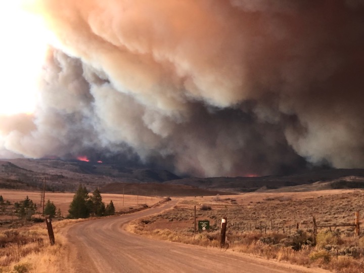
Firefighters on the march: The Pine Gulch Fire, smoke of which shown here, was started by alighting strike on July 31, 2020, approximately 18 miles north of Grand Junction, Colorado. According to InciWeb, as of August 27 2020, the Pine Gulch Fire became the largest wildfire in Colorado State history, surpassing Hayman Fire that burned near Colorado Springs in the summer of 2002. Photo credit: Bureau of Land Mangement-Colorado, via InciWeb and National Interagency Fire Center.
If there were any doubts that the climate is changing in the Colorado River Basin, 2020 went a long way toward dispelling them, thanks to yet another year of extreme weather.
Unprecedented wildfires, deadly heat waves, withering drought—the many indicators of the climate mayhem that scientists have been warning about for years—ravaged the landscape, claiming dozens of lives and causing billions of dollars in damage.
Colorado endured an unprecedented wildfire season. And so did California, in some cases burning where the wounds were still fresh from the epic fires of 2018. Utah experienced its driest year ever, and persistent high temperatures killed more people in Arizona than ever before. Monsoon rains that typically bring relief throughout the region were a no-show for the second summer in a row and now are being called the “non-soon.”
And, although the final climate data for 2020 just arrived and the new year is just weeks old, forecasters are already filled with apprehension about what lies ahead for the West this year.
“We’ve got a pretty deep hole that 2020 has dug for us,” said Jon Meyer, research climatologist for the Utah Climate Center who points to low soil moisture, high temperatures and other measures of a hotter, drier climate. “Even a good year is not going to break us out of that.”
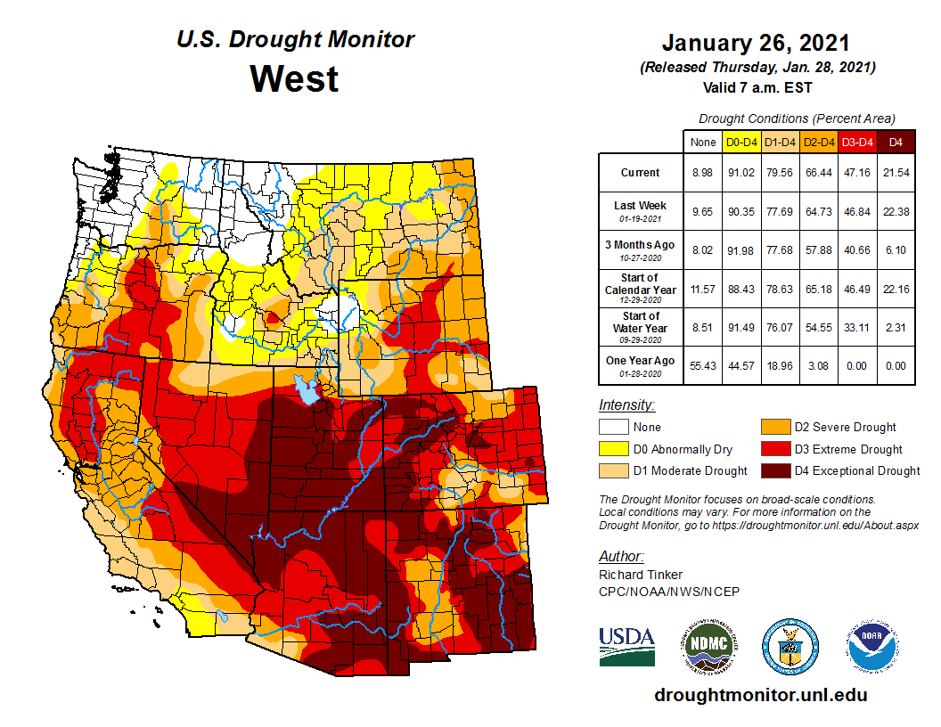
West Drought Monitor January 26, 2021.
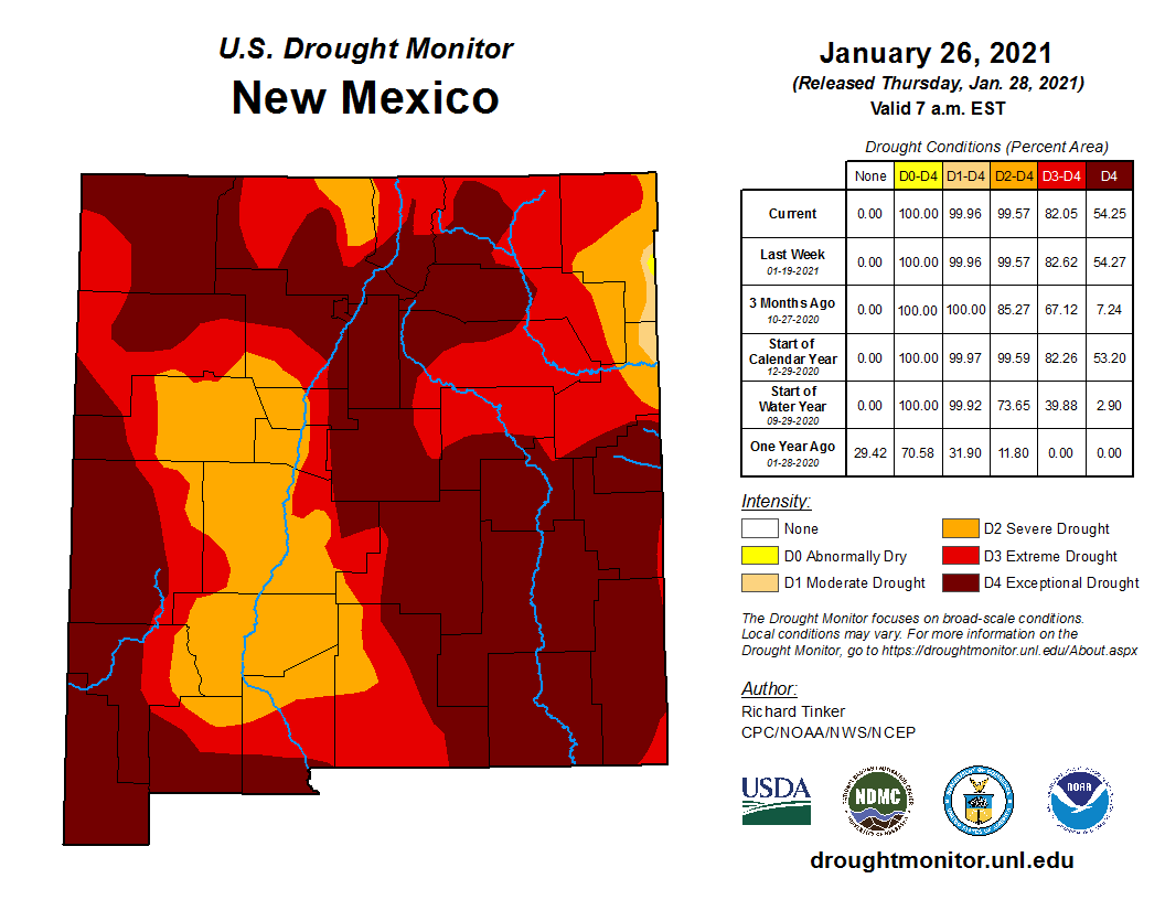
From the California coast to the eastern borders of Colorado and New Mexico, 2021 is beginning with virtually all of the Colorado River Basin in “extreme” or “exceptional” drought, conditions that haven’t been eased by this winter’s snowfall. Forecasters talk about a “snow drought” because the snowpack is so poor and snow cover across the West is lower than at any time over the past two decades. This year Lake Powell, the nation’s second largest reservoir, is expected to receive just half as much runoff as usual.
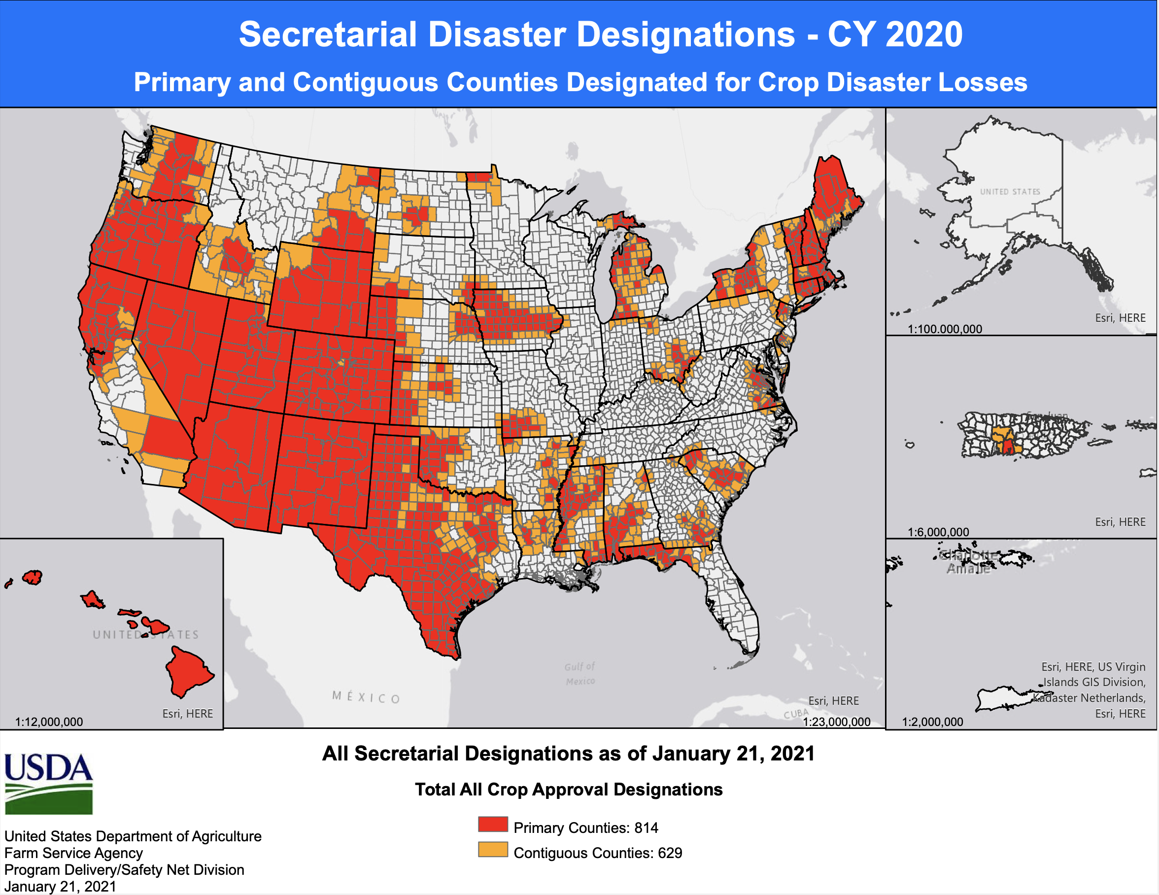
Record Numbers of Billion-Dollar Disasters and Deaths
Heat turned out to be the biggest factor in weather and climate related deaths in a dozen western and central states last year, according to the latest national billion-dollar disasters tally. The drought and heat wave caused 45 deaths—most of them heat-related—said Adam Smith, who collects the data for NOAA’s National Centers for Environmental Information.
Smith’s analysis is fast becoming a key metric in measuring the impacts of climate change. It compiles the costs in property damage and human lives associated with growing populations, more assets in harm’s way and the increased frequency of extreme weather, much of it driven by global warming. Last year the tally detailed $95 billion in costs tied to 22 events, the largest number of billion-dollar disasters recorded since NOAA began the list in 1980.
Secretarial Disaster Declarations as of January 21, 2021.
Smith said the estimate includes a broad range of quantifiable costs, such as damage to commercial and residential properties, crop losses, increased feeding costs for livestock and spending on fighting wildfires…
A Thirstier Atmosphere Dries Out Farms and Drives Fires
Mistie Christiansen, who oversees USDA Farm Service Agency programs in central Utah’s Emery and Carbon counties, said the climate trends are disrupting life on the land and the people who depend on it.
“Ponds are dry; streams are dry; springs that would normally have supplied livestock and rangeland are dry; rivers are historically low,” she said. “It’s the compound factor of multiple years of this issue that’s really hard. People are really struggling.”
Area ranches and farms that depended on irrigation from Muddy Creek ran out of water by the end of last June. Her family cut just one crop of hay instead of the usual three and had to spend $45,000 to buy more to feed its livestock. This year, they’re expecting to spend at least $30,000 to make up for what the desiccated land cannot provide. Meanwhile, the cows are weaker and pregnancy rates are down, she said.
Based on the string of rough years and how things are looking now, Christiansen said she wouldn’t be surprised to see another bad year for livestock growers. “And if things don’t change, you’ll see a major sell off,” she said.
Despite the pain that global warming brings to rural communities like hers, Christiansen believes a higher power is changing the climate, not humans. Still, she shares one view with many climate scientists.
“There’s no longer normal,” Christiansen said. “I would love to see what is normal anymore, because we just swing from extremes.”
Jeff Lukas, an independent climate consultant in Colorado, said the world’s rapid warming is making the atmosphere thirstier “and that is so apparent in the second half of 2020.” Dry years can happen in the absence of climate change, he said. But the atmosphere’s capacity to hold more water, which leads it to suck moisture from the soil, trees and snowpack, has increased significantly in response to what might seem like an insignificant amount of warming—about 2 degrees Fahrenheit.
“What [last year] will be mostly remembered for, from a weather and climate perspective, is how things dried out so much in the summer and fall as a result of both low precipitation and very high temperatures,” said Lukas, who tracked climate and weather events at the Western Water Assessment for more than a decade. The dryness “led to the kind of fuel conditions and fire weather, that led to those incredible wildfires in August and September.”
East Troublesome Fire. Photo credit: Brad White via The Mountain Town News
For Lukas, one day-long period of extreme fire behavior last year stands out: when Colorado’s East Troublesome Fire ran 20 miles, expanding from 18,000 acres to 180,000 acres, eventually jumping over the Continental Divide in Rocky Mountain National Park last October. He noted that the heat, aridity and winds that set the stage for the blaze are not completely unheard of in autumn. But for such a fire to ignite and grow into the second largest blaze in state history in October, a month that is normally cool and moist, is unprecedented…
2021 Set Up For More Heat and Drought
No one’s started using the word “scary” yet, but all reports seem to suggest 2021 could bring more of the same.
The snowpack for the Colorado River’s four Upper Basin states—Utah, Wyoming, Colorado and New Mexico—is 67 percent of average. That puts this year on par so far with 2018, which went on to be a terrible year for wildfire, drought and heat.
With reservoirs already low, the U.S. Bureau of Reclamation recently nudged those states to prepare for implementing the Upper Basin Drought Contingency Plan so Lake Powell can continue next year to meet the demands of the 40 million people who rely on Colorado River water.
The water that’s flowed into Lake Powell since October is 44 percent of the normally expected flow.
Drought is expected to persist into spring, and odds are that Colorado River Basin states will remain warmer and drier than normal, too.
“There really isn’t any good news for water resources in the Colorado River Basin right now, which is raising a lot of red flags coming into the upcoming year,” said Jon Meyer of Utah’s Climate Center.
Moraine Park and the headwaters of the Big Thompson River in Rocky Mountain National Park. Moraine Park is on the east side of the park and of the continental divide, near the town of Estes Park. This region has a number of areas call “parks”, which refer to open, level areas in the mountains, usage which comes from the French word parque. The names of these areas predate the establishment of the national park and are unrelated to the use of the word “park” in that context. By The original uploader was Kbh3rd at English Wikipedia. – Transferred from en.wikipedia to Commons., CC SA 1.0, https://commons.wikimedia.org/w/index.php?curid=1009783
Peaks to People Water Fund have launched its Big Thompson Initiative in Northern Colorado to proactively treat wildfire risk through accelerated forest restoration and stewardship in the watersheds.
The Big Thompson watershed’s water infrastructure supplies between 40 percent and 55 percent of Fort Collins, Loveland, and Greeley’s annual water needs, providing water to 30 additional towns and cities along the state’s front range. The state’s forests have become dense and overgrown after years of protection from wildfire, which has increased the risk of severe wildfires such as the Cameron Peak Fire that threaten water supplies with sedimentation and debris.
“Living in an environment where fire is part of the natural cycle is our reality in Northern Colorado, but Peaks to People and its partners are working to return the forest to a healthy condition that minimizes the intensity of fires when they do strike,” said Alex Castino, Great Outdoors Colorado Land Protection Program Officer. “This allows people and small businesses, plants and animals, waterways and water infrastructure, to bounce back quickly and thrive in this beautiful place we all call home,” Alex said.
East Troublesome Fire and Cameron Peak Fire map via Inciweb December 7, 2020.
The Cameron Peak and East Troublesome wildfires west of Fort Collins emphasize the urgent need for proactive treatment with a combined cost of over $149 million to suppress them and more than 1,000 miles of river impacted. The Peaks to People Water Fund team has analyzed and determined that treating 37,000 acres within the 575,000-acre Big Thompson watershed could reduce 90 percent of severe fire risk while conserving the forests most essential for water supply.
Peaks to People plans to invest a total of $90 million through the Big Thompson Initiative over the course of the next ten years to restore forests to their natural state and reduce the risk of severe wildfires. Treatments are costly at as much as $3,600 per acre with Peaks to People working with partners to leverage funds to stretch contributions…
Peaks to People have partnered with the Colorado State Forest Service, Nature Conservancy of Colorado, Big Thompson Conservation District, Larimer County Department of Natural Resources, Colorado Forest Restoration Institute, Brendle Group, and the Center for Collaborative Conservation to make this initiative successful. More funding must be raised to accomplish the initiative’s goals even though some funding is already in place.
Fishing the Big Thompson River. Photo credit: Larimer County
The San Juan Water Commission is considering asking for a release of Animas-La Plata Project Water. This water is stored in Lake Nighthorse in Durango, Colorado.
If the commission chooses to move forward with the release, it would be the first time that water is released from Lake Nighthorse upon the request of the San Juan Water Commission.
During the drought of 2018, the San Juan Water Commission took steps to request a release on behalf of the City of Farmington. However that release was cancelled as storms brought rain to the Four Corners region.
The water commission has been discussing a release from Lake Nighthorse as a test run that would allow it to address potential issues that could emerge. For example, making sure the water released from the reservoir reaches its intended destination.
The San Juan Water Commission meets at 9 a.m. Feb. 3 via Google Meets. A link is available on the agenda posted at sjwc.org.
Other agenda topics include legislation and long-term water development opportunities.
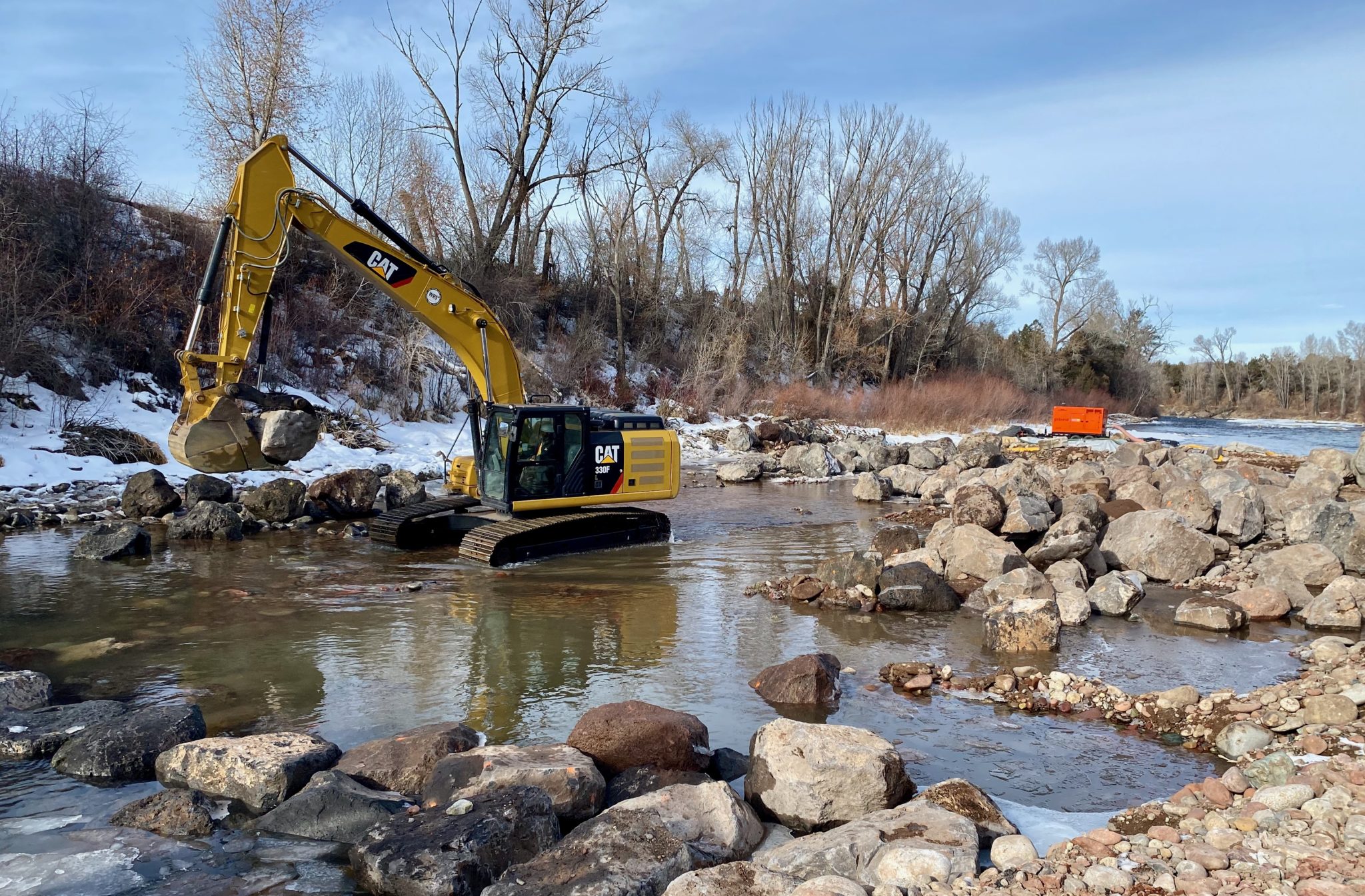
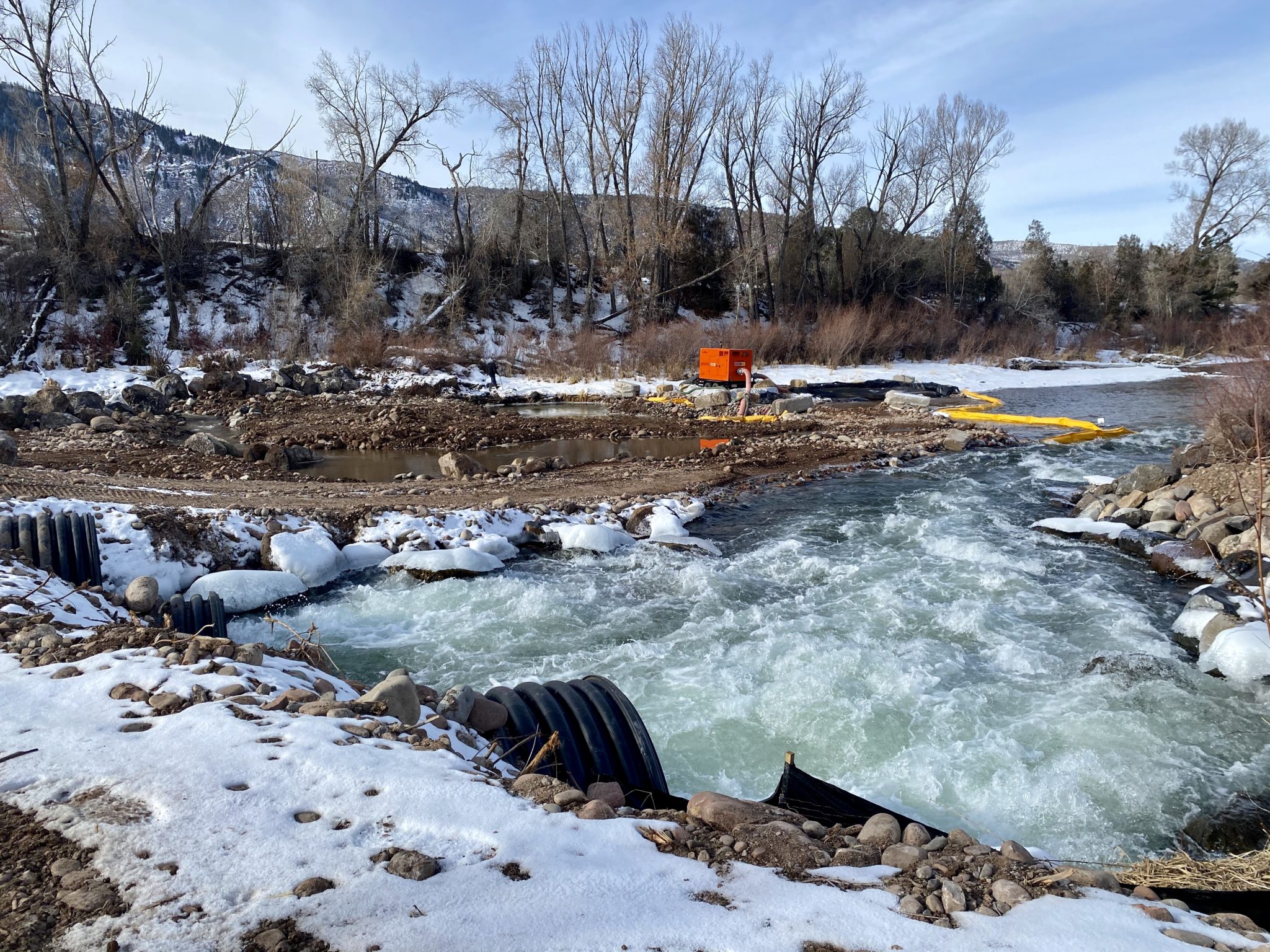
An excavator works in the bed of the Roaring Fork River near Basalt below a temporary dam. Boulders were being arranged to create one of two grade-control structures that will smooth out a section of river previously home to a steep drop created by a weir that channeled water to a diversion ditch. Photo credit: Curtis Wackerle/Aspen Journalism
Work currently underway in the Roaring Fork River between old town Basalt and Willits will make for a smoother ride for boaters beginning this spring.
The project, with an estimated price tag of $935,000, requires a temporary cofferdam during construction across much of the river’s channel, with heavy machinery in the exposed river bed. It will create two new “grade-control” structures to replace a weir that was used to channel water toward a diversion for the Robinson Ditch. That weir created a difficult passage for boaters that was often referred to as Anderson Falls.
Instead of that steep drop with no clear passage around or through, the project has been designed by Carbondale-based River Restoration to create a gradual riffle drop between the grade-control structures. The Robinson Ditch diversion structure, which delivers raw water for outdoor irrigation from April through October to customers in the Mid Valley Metropolitan District, will also be rebuilt as part of the project.
An excavator arranges boulders to create one of two grade-control structures in the Roaring Fork River, part of a $935,000 project to smooth out a section of river previously home to a steep drop. Photo credit: Curtis Wackerle/Aspen Journalism
Work on the project, which was approved for funding in March by Pitkin County’s Healthy Rivers and Streams board of directors, began in December and is permitted to take place through March 15, said Quinn Donnelly, an engineer with River Restoration.
The weir, he said, created “probably one of the bigger navigation hazards” on the Roaring Fork, resulting in many boaters avoiding that stretch, which is just above a boat ramp near the FedEx facility off of Willits Lane.
“We are trying to make a natural riffle here” that meets the needs of boaters, Donnelly said. Making that stretch of the middle Roaring Fork more accessible might also have the added benefit of taking pressure off other stretches of river and more crowded boat ramps farther downvalley, he said.
The project should also improve fish habitat as water scours the riverbed around the newly placed boulders.
The cofferdam is blocking the river across most of the channel, funneling the Roaring Fork’s winter flow into a series of culverts on river right. On Thursday morning, an excavator was picking up 3- to 6-foot-diameter boulders and arranging them in a line to form the upper grade-control structure. The site is visible from the bike path connecting Willits Lane to Emma Spur.
Donnelly said that most of the boulders that were being placed this week will be buried by alluvium below “scour depth,” with more rocks placed on top. The project has been designed to keep the ditch headgate clear of sediment and debris carried downstream.
Once the grade-control structures are completed, the current cofferdam will be removed. A second temporary cofferdam will be installed at river right to allow for the new headgate to be built. That, too, will be removed before the project is complete and the river flows unimpeded through the section.
As of last year, project planners had secured $256,200 in grants, including a $171,216 Colorado Water Plan grant and a $45,000 Water Supply Reserve Fund grant from the Colorado Water Conservation Board, as well as a $40,000 Fishing Is Fun grant from Colorado Parks and Wildlife.
Pitkin County’s Healthy Rivers fund, supported by a 0.1% sales tax, will cover the difference when all grants have been applied, said Lisa MacDonald, who works in the Pitkin County Attorney’s Office and provides staff support for the Healthy Rivers program.
MacDonald and Donnelly credited the Roaring Fork Conservancy and the Roaring Fork Fishing Guide Alliance for supporting the project. Donnelly noted that in any river project, there are myriad interests in play involving water users, riparian habitat and recreation. It is a balancing act, he said, but a successful model involves bringing stakeholders together and that has been the goal here.
The Roaring Fork River flows through culverts while being channeled around a temporary dam put in place to allow contractors to work on a project to smooth out a section of river previously home to a steep drop. Anderson Falls, which was created by a weir that funneled water into a diversion ditch, will be gone this spring. Photo credit: Curtis Wackerle/Aspen Journalism
Robinson Ditch Co. president Bill Reynolds, who is also the director of the Mid Valley Metropolitan District, said he’s happy to see the project making progress and believes it will enhance the experience for river users.
The ditch company paid for the engineering and design of its diversion infrastructure, he said. That infrastructure makes it possible for users in a wide swath of the midvalley to irrigate using raw water, as opposed to more-expensive treated potable water, which the district also provides via a series of wells, he said.
Ditch companies typically rely on government grants to make infrastructure improvements, he said, expressing gratitude for Pitkin County’s model of supporting river projects.
“Pitkin County and the funding mechanisms they’ve been using have been a blessing,” Reynolds said.
This story ran in The Aspen Times on Jan. 30.
The headgate for the Robinson Diversion is located on river right, just upstream from the boat ramp on Willits Lane on the Roaring Fork River. The Pitkin County Healthy Rivers Board is moving forward on a nearly $1 million project to fix the Robinson Diversion structure. Photo credit: Heather Sackett/Aspen Journalism
The headgate for the Robinson Diversion is located on river right, just upstream from the boat ramp on Willits Lane on the Roaring Fork River. The Pitkin County Healthy Rivers Board is moving forward on a nearly $1 million project to fix the Robinson Diversion structure. Photo credit: Heather Sackett/Aspen Journalism
The Robinson Diversion, located just upstream from the boat ramp on Willits Lane has long presented a hazard for boaters on the Roaring Fork River. Pitkin County Healthy Rivers has secured roughly $256,000 in grant money to permanently fix the area. Photo credit: Heather Sackett/Aspen Journalism
A view of the headgate on the Robinson Ditch and the boulder structure in the Roaring Fork River that maintains the grade of the river so water can reach the headgate. Pitkin County has received a water-plan grant to help repair the diversion structure and improve boating passage. Photo credit: Brent Gardner-Smith/Aspen Journalism
New Mexico water agencies are urging farmers to think twice about planting crops in what could be a tight water year. The state faces a big water debt to downstream users, and a multi-year drought is taking its toll.
The Office of the State Engineer recommends “that farmers along the Rio Chama and in the Middle Valley that don’t absolutely need to farm this year, do not farm,” according to a staff report that Interstate Stream Commission Director Rolf Schmidt-Petersen presented to the Commission earlier this month.
Irrigation supply along the river from Cochiti Dam to Elephant Butte Reservoir is governed by the Middle Rio Grande Conservancy District. The district cut its 2020 irrigation season a month short, because there wasn’t enough water to go around. A shorter season also helped deliver some river water to Elephant Butte as part of New Mexico’s Rio Grande Compact obligations.
In January, the district board voted to delay the start of the 2021 season until April 1, a month later than usual.
This year is on track to be a situation of water shortages and storage restrictions unlike any since the 1950s, said Mike Hamman, the district’s chief engineer and CEO and an Interstate Stream Commissioner. The district also anticipates receiving as little as half the usual allotment of San Juan-Chama water.
“The hydrology really started to shift in the early ’90s,” Hamman said. “We’ve got into this cycle of below-average, average, above-average years, and I’ve noticed that our climatic conditions (limit) the available snowpack. That exacerbates things a little bit more now, where we need to have well-above-average snowpacks to address the poor watershed conditions that may have resulted from a poor summer rain period or fall moisture.”
[…]
Regional farmers are advised to prepare for severe water shortages by exercising “extreme caution” in planting crops this spring and by using any available water only for the most essential uses…
The current Rio Grande Compact water debt of about 100,000 acre-feet, or 32 billion gallons, restricts how much the state can store in reservoirs.
By the end of January, the state will have released about 3,200 acre-feet, or about 1 billion gallons, of “debit water” from El Vado and Nichols Reservoir near Santa Fe to Elephant Butte.
Last year’s monsoon season from May to September was the driest on record for New Mexico.
The Rio Grande could go completely dry this summer all the way from Angostura Dam north of Bernalillo through Albuquerque, especially if this year brings another lackluster monsoon season…
‘Last page in our playbook’
The fail-safe options New Mexico relied on last year to stretch the Rio Grande water supply won’t be available this year. This summer on the river may look like what water managers and environmental groups worked to stave off during last year’s hot, dry summer months.
The Middle Rio Grande didn’t look good in July 2020. The MRCGD had just a few days of water supply left.
No water could have meant no irrigation for farmers, but also limited river habitat for endangered species, scarce drinking water supply for local communities, and meager flows for river recreation.
Then came word from the other Rio Grande Compact states of Colorado and Texas: New Mexico had permission to boost river flows by releasing a total of 12 billion gallons from El Vado Reservoir.
“That was the last page in our playbook, or pretty darn close to it,” Schmidt-Petersen told the Journal.
The release kept the Rio Grande from drying completely in the Albuquerque stretch and helped extend the irrigation season for central New Mexico farmers.
Colorado River water diverted via the San Juan-Chama Project also added to the trickling native Rio Grande flows.
Last summer’s massive release from El Vado was water that had been stored as assurance that the state’s Rio Grande Compact debt would be paid.
That water is gone. New Mexico still has to “pay back” the 12 billion gallons, plus any obligations accrued this year.
State Engineer John D’Antonio said the drought is shaping up to be as severe as the conditions the state experienced in the 1950s.New Mexico Drought Monitor January 26, 2021.
Gov. Michelle Lujan Grisham’s December 2020 emergency drought declaration could provide some financial relief for communities affected by the record-setting dry conditions.
“There could be appropriated up to $750,000 for each eligible and qualified applicant that the governor may designate from the surplus unappropriated money in the general fund, if there is any,” D’Antonio said.
The state Drought Task Force would determine which organizations or local governments receive the money, which under the emergency declaration could be used for water conservation projects, to offset economic losses caused by the drought, or as a match for federal funding.
Dylan Wilson on the banks of the Rio Grande near Las Cruces, N.M. Photo credit: Allen Best
Gloomy forecast
New Mexico will endure another double whammy of limited water supply and growing Rio Grande Compact water debt if snowpack levels don’t improve dramatically by early spring.
Statewide snowmelt runoff forecasts published Jan. 1 showed most of New Mexico at less than 80% of normal levels.
Since then, some snowstorms have brought much-needed moisture to the northern half of the state.
But New Mexico needs several months of above-average snow and rain to dig out of a drought before the hot summer months.
Westwide SNOTEL basin-filled map February 1, 2021 via the NRCS.
Groundwater wells in the lower Rio Grande region of southern New Mexico supply water for municipal and agricultural uses when the river is low.
“That’s not the same in the middle valley for all the farmers there,” Schmidt-Petersen said. “There are limitations on wells that have been in place for long periods of time, so some places can pump and some cannot, and similarly all the way up the Chama.”
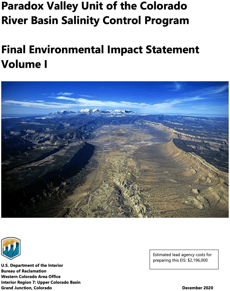
Various efforts along the river or tributaries annually remove about 1.2 million tons of salt. But the largest brine-removal system in the basin has been shuttered for two years over earthquake concerns. In December, President Donald Trump’s outgoing administration released a final environmental review on what to do about it.
The chosen course: No action, leaving the fate of the project and of salt removal murky. Now local suppliers say they will be pressing the Biden administration to do the opposite.
“For the last two years the salt has been flowing back into the river,” said Bill Hasencamp, chair of the Colorado River Basin Salinity Control Forum, which represents all of the states that draw from the river. “We were very disappointed. There’s no plan to capture [it] going forward.”
Water suppliers have filed comment letters about the “no action” decision and sent letters to former Reclamation Commissioner Brenda Burman. The average annual economic loss from salinity levels in the Colorado River is estimated to be $495 million, Reclamation said in its environmental review.
Seismic Threat
At issue is the Paradox Valley Unit near the Colorado-Utah border. The project, in operation since 1996, took saline groundwater before it could hit the Colorado and the Dolores River, a tributary, and injected it more than three miles beneath the surface into a well disconnected from the river system. About 95,000 tons of salt were removed each year.
But injecting, like hydraulic fracturing, can cause seismic shifts.
Reclamation shut down Paradox Valley in March 2019 after a magnitude 4.1 earthquake, which the U.S. Geological Survey considers moderate in size. Operations resumed for a six-week test at reduced use in spring 2020, but the well currently isn’t operating.
Technical experts are evaluating next steps and it’s too soon for the agency to propose a new salinity control plan, Reclamation spokeswoman Linda Friar said in an email.
The agency currently doesn’t plan to issue a record of decision, which would finalize the “no action” plan Reclamation selected, she said.
Hasencamp, also manager of Colorado River resources for the Metropolitan Water District of Southern California, and others had pushed for that delay in comments filed with Reclamation earlier this month…
Rejected Options
In its environmental review, Reclamation considered and rejected building a new injection well, using evaporation ponds for brine to be treated at the surface, and building a discharge facility to evaporate and condense water before sending salt to a landfill.
The “no action” alternative was “in the best interest of public health and safety,” Ed Warner, Reclamation’s Western Colorado Area office manager, said in a news release.
James Eklund, former director of the Colorado Water Conservation Board, said when he served as the state’s representative on salinity control programs, he was “pretty adamant” that the bureau should switch from earthquake-causing deep injection wells to evaporating ponds in order to deal with the saltwater. Eklund is now at Denver-based Eklund Hanlon LLC…
Economic Losses
But more than 600 miles south, the loss of Paradox Valley could increase salinity levels at Imperial Dam by 9 to 10 parts per million, which could lead to $23 million in estimated economic losses each year, Harris, from the Colorado River Board of California, said in a December letter to Burman, a Trump appointee no longer in office.
The EPA doesn’t have a drinking water standard for sodium chloride, but it has a voluntary standard of 250 parts per million for chloride, a component of salt. Voluntary standards are generally related more to aesthetic concerns like taste and appearance.
“It’s not huge, but we get essentially a ton of salt in every acre-foot of water,” said Tina Shields, water manager for Imperial Irrigation District, which borders Mexico. “If you don’t continue to implement these upstream salinity control measures by default, it can only go up.”
Nearly all farmers in the Imperial Irrigation District have drains installed beneath the surface to leach salt away from crops, which requires even more water. But that’s not a permanent solution.
Imperial is the last stop for water before it gets into Mexico, where the Colorado River delivers water to 2.3 million people and 500,000 acres of agriculture…
Expensive Treatment
Urban areas will be able to weather the salt problem better than agricultural ones because they have mass treatment to comply with drinking water standards, said Patricia Mulroy, former general manager of the Southern Nevada Water Authority and owner of the consulting firm Sustainable Strategies.
Paradox Valley Location Map. Credit: Bureau of Reclamation
The Paradox Valley in western Colorado, a place with uranium mineral deposits. (Photo by Emily Hunnicutt via Flickr: Creative Commons)