Click on a thumbnail graphic to view a gallery of drought data from the US Drought Monitor.


Click here to go to the US Drought Monitor website. Here’s an excerpt:
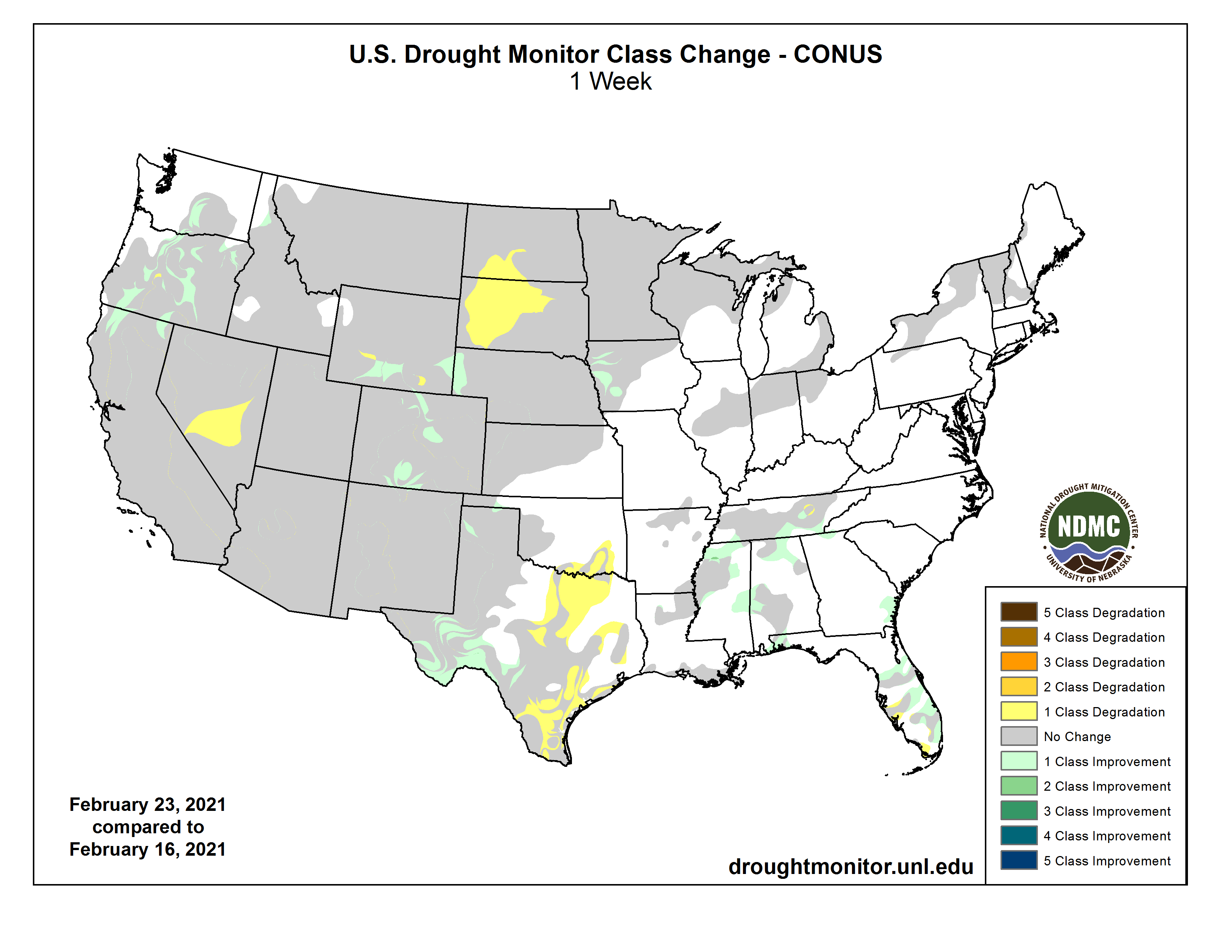
This Week’s Drought Summary
After a frigid start to the period, especially throughout the middle third of the Nation where daily temperature anomalies were 30 to 40 degrees F below normal and readings dropped below -40 degrees F in Minnesota and 0 degrees F as far south as central Texas, temperatures finally moderated by week’s end. By Monday, highs had risen into the 40s & 50s degrees F in the Dakotas and 70s and 80s degrees F in Texas. Frequent Pacific storms battered the Northwest, and then tracked southeastward across the Northern and Central Rockies, dropping plentiful moisture on Washington, Oregon, northern California, Idaho, & western Montana, but missing most of the Southwest yet again. Storms also dropped widespread precipitation on much of the Southeast, mid-Atlantic, and coastal New England while most of the Midwest saw light frozen (snow, sleet, freezing rain) precipitation. Dry weather was observed across much of the Plains except in south-central Texas. Weekly temperatures averaged below to much-below normal throughout the lower 48 States except for central and southern Florida. Readings in Alaska remained below-normal except in the southwest and Aleutians, and significant precipitation was limited to along the southwest, southern, and southeastern coasts. Meanwhile, Hawaii experienced increased shower activity, especially on Kauai where some flash flooding occurred. In Puerto Rico, light showers persisted across eastern sections while the northwest remained mostly dry, and dryness/drought increased.
The ensuing 5 days (March 2-6) expects favorable odds for above normal precipitation across much of Alaska and in the Tennessee Valley and Carolinas. Subnormal precipitation should prevail across the North-Central States (northern halves of the Rockies and Plains and Great Lakes region) and along the western Gulf Coast, with Equal Chances (EC) elsewhere in the lower 48 States. Subnormal temperatures are likely in Alaska and the Far West, with above normal readings anticipated for the eastern two-thirds of the Nation (except EC for New England)…
After several weeks of light to moderate snow events in the Central Plains, drier (but still frigid conditions, although moderating by week’s end) weather returned to the region. With the recent improvements in the Central Plains and subnormal temperatures, no changes were made there. Farther north, however, even though precipitation is normally low during the fall and winter seasons, it has been extremely dry during the past 3-4 months (less than 25% of normal), leading to a lack of any snow cover in eastern Montana, western North Dakota, and north-central South Dakota. Short-term indices (1-, 2-, 3-, 4-, and 6-months) were at D3 and D4 levels, thus D2 was expanded southward across south-central North Dakota and central South Dakota, and D1 added in north-central South Dakota. In contrast, additional precipitation in Wyoming and Colorado boosted mountain snow water equivalent (SWE) as of Feb. 23 at or closer to normal, thus some improvements were made across southern and southeastern Wyoming and in parts of north-central and south-central Colorado. A few areas in Wyoming had missed out on the recent snows, so some slight degrading was made to those areas…
Ample Pacific moisture and storms dropped decent amounts of precipitation on the Northwest, especially Washington, Oregon, northern California, Idaho, western Montana, and western Wyoming, with lesser amounts across northern Nevada, central Utah, northern and southern Colorado, and parts of New Mexico. The active Pacific storm track continued to benefit Washington, Oregon, and northern California, along with most northern and central mountains in the West. February 23 basin average SWEs continued to increase toward normal, with most basins in Washington, Oregon, Idaho, western Montana, and northwestern Wyoming at or above normal SWE. Accordingly, some slight improvements were made where recent surplus precipitation fell and the basins had SWEs exceeding 100%. With improvements made last week in northern Nevada and central Utah, and these areas still impacted from the failed Southwest summer monsoon, no changes were made this week, although the basin SWEs were up to 70-80% of normal as of Feb. 23. The light precipitation in New Mexico and eastern Arizona was not enough for any improvements this week. In California’s Sierra Nevada, the Feb. 23 SWE stood at: North – 67%; Central – 72%; South – 50%; statewide summary – 65%. In contrast, central Nevada missed out on the recent storms, and with the failed summer monsoon, conditions have gotten worse, thus D4 was expanded to include central Nevada. In addition, the Impact Lines were adjusted to show that more of the drought in the West was long-term (L) since recent storminess had pushed the short-term indices into various wet categories, although the much drier in the short-term Southwest remained in SL…
Little or no precipitation fell on the Southern Plains except across south-central Texas, improving conditions there, while light to moderate amounts (0.5-2 inches) were measured in the lower Mississippi Valley (Louisiana, Arkansas, Mississippi, Tennessee). Where enough precipitation fell to make a significant dent in the short-term deficiencies, a 1-cat improvement occurred (e.g. northern and eastern Mississippi, southern Tennessee). However, the greatest rains seemed to fall on non-drought areas. In contrast, little or no precipitation fell on south Texas and northeastern Texas into southeastern Oklahoma, expanding drought severity and area there. USGS 7-day average stream flows have dropped into the below to much-below normal levels…
Looking Ahead
During the next 5 days (February 25-March 1), storms will impact the Pacific Northwest, especially Washington, Oregon, and Idaho, and then track southeastward, gathering Gulf moisture before tracking northeastward. A swath of 1-4 inches of rain should fall from northeastern Texas northeastward into the mid-Atlantic, with lighter totals in the New England and the Great Lakes region. Unfortunately, little or no precipitation is forecasted for the Southwest, California, the northern and central Plains, upper Midwest, and Florida. Temperatures will average below normal in the West, Rockies, and northern Plains, and above normal in the eastern half of the Nation.