Click on a thumbnail graphic to view a gallery of snowpack data from the NRCS.

Colorado statewide snowpack basin-filled map February 19, 2021 via the NRCS.

Statewide Basin High/Low Graph February 18, 2021 via the NRCS.

Yampa and White interactive graph February 19, 2021 via the NRCS.

Colorado River headwaters interactive graph February 19, 2021 via the NRCS.

South Platte River Basin High/Low Graph February 18, 2021 via the NRCS.

San Miguel, Dolores, Animas, and San Juan Basin High/Low Graph February 18, 2021 via the NRCS.

Rio Grande River headwaters Basin High/Low Graph February 18, 2021 via the NRCS.

Laramie and North Platte Basin High/Low Graph February 18, 2021 via the NRCS.

Gunnison River Basin High/Low Graph February 18, 2021 via the NRCS.

Arkansas River Basin High/Low Graph February 18, 2021 via the NRCS.
From The Fort Collins Coloradoan (Miles Blumhardt):
Fort Collins picked up about 5 inches of snow Wednesday night, creating icy conditions that prompted the city to go on accident alert for about four hours…
The storm generally produced 4 to 5 inches of snow along the northern Front Range.
Colorado snow totals
Fort Collins: 4-5 inches
Loveland: 4-5 inches
Wellington: 4-5 inches
Laporte: 4-5 inches
Mishawaka: 5.5 inches
Virginia Dale: 5 inches
Poudre Park: 6 inches
Windsor: 3 inches
Greeley: 2 inches
Estes Park: 5 inches
Berthoud: 4.5 inches
Nederland: 10 inches.
Longmont: 5 inches
Boulder: 8-10 inches
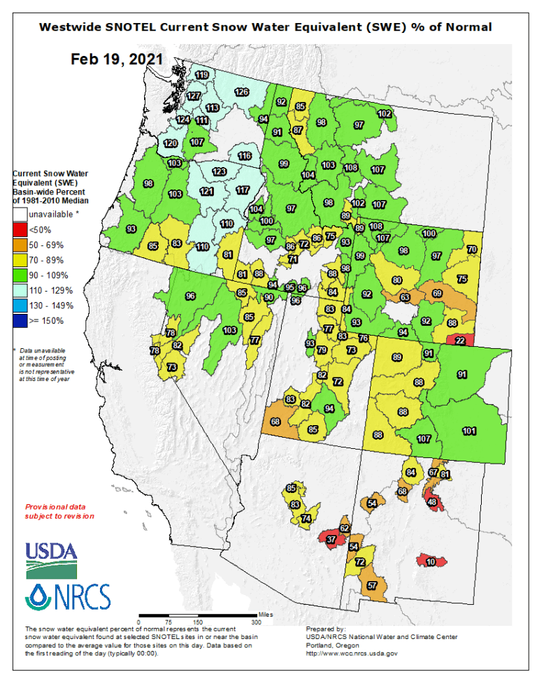
Here’s the Westwide SNOTEL basin-filled map for February 19, 2021 via the NRCS.