#Drought news January 22, 2026: Storage in the sprawling, multi-state #ColoradoRiver Basin stood at just under 17.3 million acre-feet (53% of average), reflecting long-term issues in part related to chronically elevated temperatures and a multi-decadal Southwestern drought and #aridification

Click on a thumbnail graphic to view a gallery of drought data from the US Drought Monitor website.

Click the link to go to the US Drought Monitor website. Here’s an excerpt:

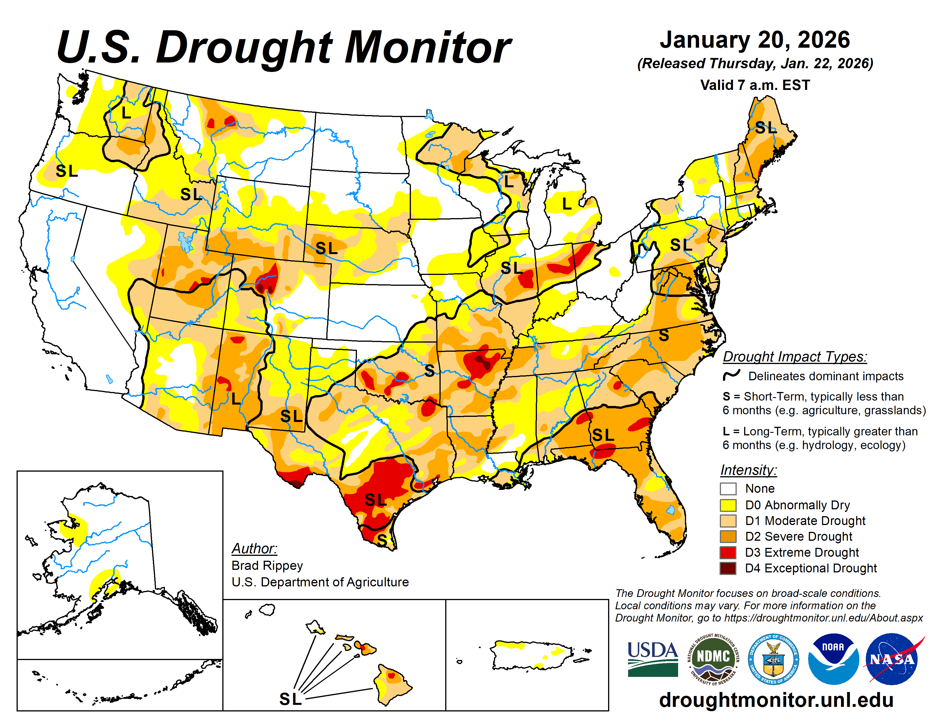
This Week’s Drought Summary

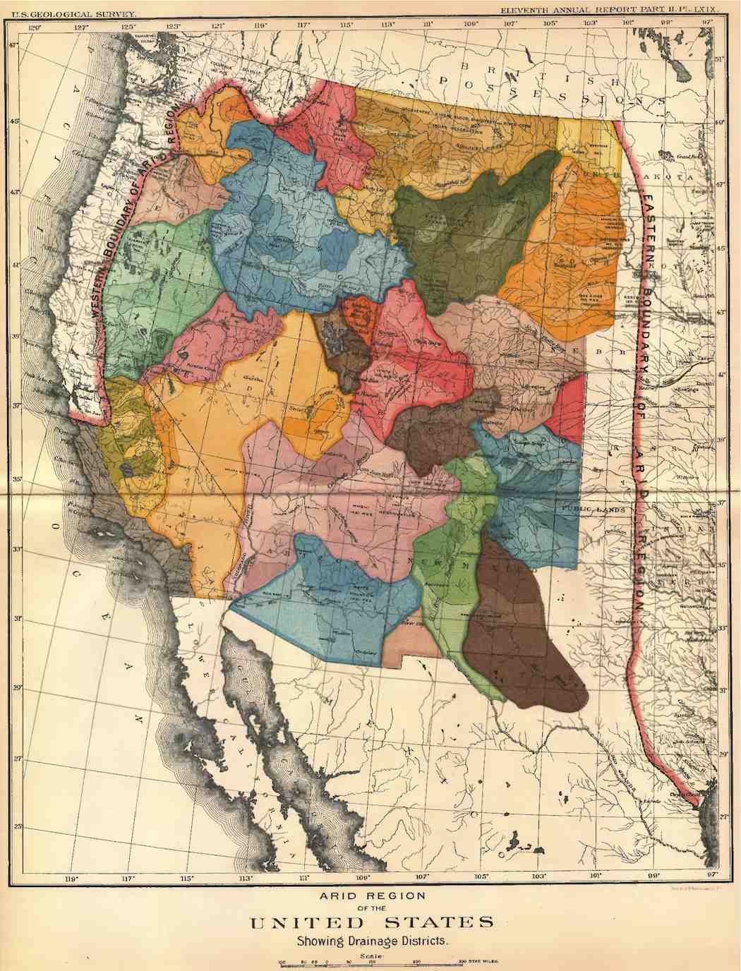
The Lower 48 States finally settled into a more tranquil weather pattern, as a ridge of high pressure settled across the West and a deep trough developed over the East. With many parts of the western U.S. reporting below-average snowpack for this time of year, the pattern change led to increasing concerns regarding Western water supply for next summer and beyond, despite robust precipitation in many areas during the first half of the winter wet season. Still, hydrologic signals were mixed, with California’s 154 primary intrastate reservoirs containing 25.9 million acre-feet of water (123% of the historic average) as 2026 began. Meanwhile, storage in the sprawling, multi-state Colorado River Basin stood at just under 17.3 million acre-feet (53% of average), reflecting long-term issues in part related to chronically elevated temperatures and a multi-decadal Southwestern drought. Farther east, the Plains served as the transition zone between mild, dry weather in the West and increasingly cold conditions in the East. The Plains’ experienced dry weather, aside from wind-driven snow showers on the northern Plains, as well as an occasionally elevated wildfire threat. Elsewhere, areas from the Mississippi Valley eastward noted cold weather, accompanied by occasional rain and snow showers. Some of the heaviest snow fell the Great Lakes States, especially in squall-prone locations. Snow also fell along and near the Atlantic Seaboard, mainly on January 17-18. As colder air became more entrenched in the Midwest and East, drought changes that had been occurring quickly in recent weeks, either due to flash drought or active winter storms, became more muted, with drought effectively ā€œfrozen in placeā€ by chilly, mostly dry conditions. During the second half of the drought-monitoring period, sub-0°F temperatures were commonly observed across the upper Midwest and neighboring regions…
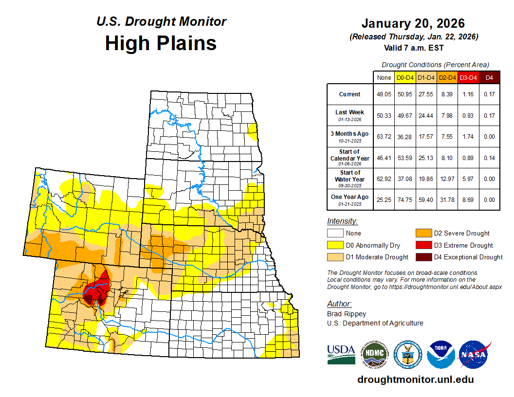
High Plains

Patchy expansion of dryness and drought was noted, mainly across Nebraska, Wyoming, and southern South Dakota. Due to periods of warm, windy weather, Nebraska reported that statewide topsoil moisture was rated 68% very short to short in early January, according to the U.S. Department of Agriculture. Similarly, Wyoming’s topsoil moisture was rated 55% very short to short…
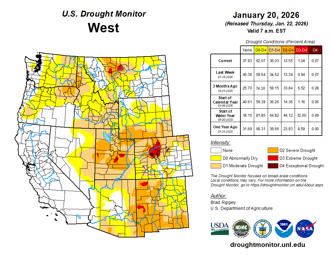
Colorado Drought Monitor one week change map ending January 20, 2026.

West

Over the last couple of weeks, an uncomfortable silence has settled across the West. With snowpack already below average in many Western watersheds due to this winter’s preponderance of ā€œwarmā€ storm systems, the mid-point of the region’s snow-accumulation season has arrived with snow-water equivalencies falling farther behind normal each day. Among Western basins, only those located in the northern Rockies and neighboring areas are reporting widespread near-normal snowpack. By January 20, snow-water equivalencies were broadly less than 50% of average in Oregon (and portions of adjacent states) and the Southwest. Although many areas of the West are reporting above-average season-to-date precipitation, the anomalous winter warmth and corresponding lack of snow could have serious future implications for wildfire activity and summer water supplies. For now, however, more than half of the 11-state Western region—including all of California—is free of drought…

South

Worsening drought was a common theme, especially from eastern Texas into Arkansas. A small area of exceptional drought (D4) was introduced in northern Arkansas, amid a punishing period of drought that has left pastures in extremely poor condition and has left many individuals with limited surface water supplies from ponds and streams. Several weeks ago, in early January, the U.S. Department of Agriculture categorized Arkansas’ topsoil moisture as 46% very short to short—and mostly dry weather has prevailed since that report was compiled. From northern Arkansas, a continuous area of severe to extreme drought (D2 to D3) extended southwestward into northeastern Texas. Patchy D2 stretched into neighboring states, including Louisiana, Mississippi, and Tennessee. Much of southern Texas, as well as southern, central, and eastern Oklahoma is experiencing moderate to extreme drought (D1 to D3)…

Looking Ahead

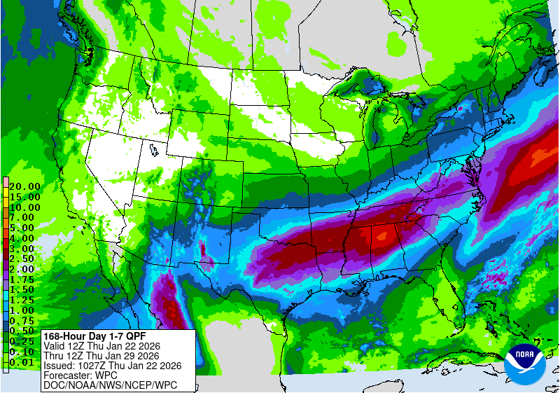
From January 23-26, an expansive and potentially dangerous winter storm will unfold from southern sections of the Rockies and Plains to the middle and southern Atlantic States, excluding areas along and near the Gulf Coast. Much of the South will face multiple weather hazards, including wintry precipitation (snow, sleet, or freezing rain), gusty winds, and unusually low temperatures. Wintry weather may extend at least as far south as central Texas and northern sections of Louisiana, Mississippi, Alabama, and Georgia. Post-storm temperatures should fall to 10°F or below along and north of a line from central Texas to northern Georgia, with particular concern for areas that lose electricity due to downed power lines from accumulations of ice and snow. Farther north, sub-0°F readings will be common as far south as the central Plains and the Ohio Valley. The storm is likely to have serious agricultural impacts, including significant stress on livestock due to exposure to cold, wind, wintry precipitation, or a combination of weather extremes. Temperatures could briefly plunge to -30°F or below from North Dakota into the upper Great Lakes region.

The NWS 6- to 10-day outlook for January 27 – 31 calls for the likelihood of below-normal temperatures throughout the eastern half of the U.S., while warmer-than-normal weather will prevail in the West. Meanwhile, near- or below-normal precipitation nearly nationwide should contrast with wetter-than-normal conditions in a few areas, including southern Florida and southern and coastal Texas.

US Drought Monitor one week change map ending January 20, 2026.

Romancing the River: The Romantic Scientist — George Sibley (SibleysRivers.com) #ColoradoRiver #COriver #aridification

Explorer John Wesley Powell and Paiute Chief Tau-Gu looking over the Virgin River in 1873. Photo credit: NPS

Click the link to read the article on the Sibley’s Rivers website (George Sibley):

January 20, 2026

There continues to be no new information from the ongoing negotiations among the protagonists for the seven states trying to work out a new two-basin management plan for the Colorado River. The Bureau of Reclamation, however, is pressing ahead; it recently went public with its ā€˜Draft Environmental Impact Statement’ (DEIS) for ā€˜Post-2026 Operational Guidelines and Strategies for Lake Powell and Lake Mead.’

The five alternative ā€˜operational guidelines and strategies’ analyzed in this DEIS were announced back in the fall of 2024; the Bureau has spent the past year-plus examining their environmental impacts. I’m not going to go into their analyses right now; I’m still working on skimming, skipping, sprinting and plowing my way through enough of the 1600 pages or so of the report to feel reasonably informed on its contents.

But I will note that the first action analyzed (skipping past the mandatory ā€˜No Action’ alternative) is for the Bureau to go ahead and run the river system as it sees fit, without input from the seven states/two basins – not something they want to do, but would have to do since the system will not wait while the states stare at their chessboard stalemate. That action would of course precipitate lawsuits from some of the states since the Bureau would have to go ahead with some of the things that are part of non-debate behind the stalemate.

Anyone wishing to submit themselves to the torture of an EIS can find the home page and Table of Contents for the report by clicking here.

And in the meantime, I’ll go off again on what I hope might be at least a more interesting tangent, and maybe more creative – fully believing that the only way out of our ever-unfolding river mismanagement is some centrifugal push to get beyond the tight centripetal pull of the Colorado River Compact and its two-basin expedient that has become gospel.

Two posts ago here, I acknowledged a need to explain why I titled all these posts ā€˜Romancing the River’ – ā€˜romance’ being a degraded term these days for many people, most commonly referring to formulaic fiction about chaotic and improbable couple-love relationships. This is a sad degradation of a word that, in more imaginative times, referred to a much larger quality or feeling of adventure, mystery, something beyond or larger than everyday life – ā€˜your mission should you choose to accept it,’ as it was expressed in Mission Impossible and The Hobbit.

ā€˜Romance’ has been used to describe our relationship with the Colorado River for more than a century. C. J. Blanchard, a spokesperson for the Bureau of Reclamation in 1918, spoke of the ā€˜romance of reclamation,’ observing that ā€˜a vein of romance runs through every form of human endeavor.’ The first book compiling the history of the Euro-American exploration of the Colorado River was titled The Romance of the Colorado River. Written by Frederick Dellenbaugh, something of an explorer himself, he first encountered the Colorado River in the company of one of the river’s greatest romantics, John Wesley Powell, on Powell’s second adventure into the canyon region of the river.

Painting by Henry C. Pitz showing John Wesley Powell and his party descending the Colorado River through the Grand Canyon, presumably during the historic 1869 expedition. (Image credit: Smithsonian Institution, Bureau of American Ethnology)

Now wait a minute, you may say: John Wesley Powell a romantic? Everyone knows he was a scientist! Well, yes, that too. A romantic scientist. Let me try to explain.

Science is a discipline, perhaps summarized in the caution: Look before you leap. Science is the discipline of looking, studying, analyzing for causes in some studies, for effects in others, basically trying to map out what is demonstrably going on in the system or structure being studied. But most scientists will acknowledge being also moved by feelings, convictions, beliefs that lie outside of or beyond the linear relationships of cause and effect explorations. The extreme example might be scientists who believe in a god or gods that oversaw the creation they are studying. More subtly, the very desire to pursue a life in science reflects a belief beyond evidence that the work is important as well as interesting. This is the ā€˜romance’ underlying science and those who pursue it.

The same year Dellenbaugh published his Romance, 1903, another southwestern writer, Mary Hunter Austin, came out with her Land of Little Rain, a poetic collection of her explorations in the deserts of the lower Colorado River region. In that book she offered what might be a cautionary note about ā€˜romancing the river.’ In an observation about a small central Arizona tributary of the Colorado River, ā€˜the fabled Hassayampa,’ she reports an unattributed legend: ā€˜If any drink [of its waters], they can no more see fact as naked fact, but all radiant with the color of romance.’

That could be construed into a kind of spectrum, the ā€˜naked facts’ of any situation at one end, the ā€˜radiant colors of romance’ dressing up the naked facts at the other end. The discipline of science is to stay as close to the ā€˜naked facts’ as possible. But is it a bad thing to allow feelings or beliefs to dress up the naked facts with the radiant color of romance?

Hold that question for a bit, and back to Major John Wesley Powell. Powell was a scientist by nature – meaning born a curious fellow who collected information about things that made him curious. He studied science in a couple of colleges, but never completed a degree – partially, probably, because college science was a little too tame. One of his early ā€˜field trips’ was a solo trip the length of the Mississippi River in a rowboat. Another was a four-month walk across the ā€˜Old Northwest Territory’ state of Wisconsin. Both of those trips pretty unquestionably fall more into the category of ā€˜romantic adventures’ than ā€˜scientific expeditions.’

As a son of an itinerant farmer/preacher immigrant, growing up on farms in rural New York, Ohio and Illinois, he also shared, to some extent, the romantic Jeffersonian vision of ā€˜another America,’ a nation of small decentralized and mostly locally-sufficient communities of farm families – now just a nostalgic fantasy-vision of nation building that still haunts the imperial urban-industrial mass society that America has become. But trips to the west had convinced Powell that the mostly arid lands of the West were largely unsuitable for the spread of that agrarian vision, without the development of an appropriate system for settlement and land management specifically for the arid lands.

He had ideas about that, things to say, but he was basically just a high-school teacher who spent his summers adventuring west; how could he get a hearing for his concerns and ideas? He needed some way to gain public attention. So he turned his destiny over to his romantic adventurer side: he would do a scientific investigation into one of the remaining blank spots on the continental map, the region beginning where the rivers draining the west slopes of the Southern Rockies disappeared into a maze of canyons, and ending where a river emerged from the canyons – a river thick with silt and sand, indicating a pretty rough passage through canyons still in the creation stage.

Wallace Stegner. Ed Marston/HCN file photo

Wallace Stegner, in his great book about Powell and the development of the arid lands, Beyond the Hundredth Meridian, credited Powell’s scientific grounding with getting him through his 1869 expedition into the canyons: ā€˜Though some river rats will disagree with me, I have been able to conclude only that Powell’s party in 1869 survived by the exercise of observation, caution, intelligence, skill, planning – in a word, Science.’

I’m one of those who disagree with Stegner on that point. The advance planning for the trip sank in the first set of Green River rapids, with the wreckage of one of the boats containing a large portion of both their food supply and scientific instruments. They gradually acquired some skill at negotiating rapids (and knowing when to portage instead), but they started with no skill and paid the price. Observation was limited to the stretch of river before the next bend. Dellenbaugh asked Powell, on the second trip in 1871-72, what he would have done had he come to a Niagara-scale waterfall with sheer walls, no room for portage and no way back upriver. Powell answered, ā€˜I don’t know.’ Scientific caution was not a factor in this trip; they leapt before looking because there was no way to look first.

Stegner to the contrary, I would argue they survived the way adventurers survive (and sometimes don’t): a kind of adaptive intelligence, for sure, figuring out how to make rotten bacon and moldy flour edible, how to fabricate replacement oars, how to deal with the unexpected quickly and decisivelyBut mostly, just gutting it out, keeping spirits from crashing completely with morbid humor and routines – Powell getting out the remaining instruments to take their bearing rain or shine, getting back in the boats every morning and turning their lives over to the will of the river again.

And it worked out. Ninety-one days after starting, they made national headlines when they floated half-starved into a town near the confluence with the Virgin River. And Powell, a national hero after that, procured a government job doing a ā€˜survey’ of the Utah territory.

Then Powell the scientist took over – but the romantic side of his nature shaped his scientific work. The unstated purpose of the western surveys by the 1870s was to map out potential resources for the fast-growing industrial empire ā€˜back in the states’; Powell covered those bases, but the heart of his 1879 ā€˜Report on the Lands of the Arid Region…’ was analysis of the potential of the arid lands for fulfilling Jefferson’s romantic agrarian vision for America. All agricultural activity, he argued, would require irrigation, and there was only enough water to irrigate many three percent of the land.

John Wesley Powell’s recommendation for political boundaries in the west by watershed

He made a strong case for replacing the Homestead Act’s one-size-fits-all 160-acre homestead allotments with two alternatives for the arid lands: 1) 80-acre allotments for intensive irrigated farming, that being as much as a pre-tractor farm family could successfully tend; or 2) ā€˜pasturage’ allotments on unirrigable land of 2,560 acres, four full sections, for stockgrowers, with up to 20 irrigable acres for growing some winter hay and the ubiquitous kitchen garden. He went even further than that: settlement should not be done on a willy-nilly ā€˜first-come-first-served basis’; instead each watershed should be developed by an organized ditch company working from a plan assuring that every member got a fair allotment of water and that the water was most efficiently distributed. And the right to use that water should be bound to the land, he said. No selling your water right to some distant city!

Powell did not just recommend this in his report; he included model bills for state and federal legislation. He was of course thoroughly ignored because everything that he suggested was contrary to the romantic mythology of the Winning of the West – Jefferson’s legendary ā€˜yeoman’ conquering the wilderness, the rugged American individualist going forth with rifle, ax and Bible.

Acequia La Vida via Greg Hobbs.

That American mythology from the start was always ā€˜all radiant with the color of romance,’ with very little attention to ā€˜the naked facts’ –  which is the main reason why two out of three homesteads failed as settlement moved into the semi-arid High Plains and the arid interior West. ā€˜The naked facts’ of aridity, on the other hand, had been foundational to the communal land-grant system imported from Spain to Mexico, and it was already known to many of the native peoples already in the Americas: it takes a village and a stream to raise good crops in the arid lands. Powell observed it in the Utah Territory, where the Mormons had borrowed it from the natives and Mexicans.

Powell was philosophical about being ignored – and kept on pushing. He was ā€˜present at the creation’ of the United States Geological Survey (USGS) in 1879, the same year he presented his ā€˜Report on the Lands of the Arid Region.’ And two years later he became director of the USGS, where he tried to keep both the Agrarian RomanceĀ andĀ ā€˜the naked facts’ of aridity front and center. He tried to sell the idea of doing a complete survey of the interior West to map its water resources and the adjacent areas of possibleĀ successfulĀ settlement, and he was actually a vote or two from achieving that, and actually shutting down the homesteading process until the study was done. But once some of the senators fronting for the industrialists realized what he was doing, they shut him down with a vengeance – he quickly realized that to save the USGS, he had to resign from it, and did so in 1894. Western extractive industries depended to some extent on failed homesteaders for their labor supply.

The Powell-Ingalls Special Commission meeting with Southern Paiutes. Photo credit: USGS

Powell was not out of work, however. From his pre-canyon days he had been interested in the First Peoples of the West. While most Euro-Americans saw them, at best, as raw material for conversion to Christianity and industrial labor, and at worse, as vermin to be wiped off the land, Powell saw them as people who had survived and even thrived in the region with Stone Age technology, some still semi-nomadic, some settled in agrarian communities, and therefore people from whom something might be learned. His efforts to communicate with those he encountered in his Utah survey led to the 1877 publication of a book,Ā Introduction to Indian Languages – which led, two years later to the creation of the U.S. Bureau of Ethnology in the Smithsonian Institute with Powell as director – a position he held until his death in 1902, finally producing the firstĀ comprehensiveĀ linguistic survey of indigenous tongues,Ā Indian Linguistic Families of America, North of Mexico(1891).

In both ethnology and the geology survey Major Powell established a high standard for government science – attention to the naked facts while still trying to carry forward what Bruce Springsteen called ā€˜the country we carry in our hearts’ – the ever evolving, devolving, careening, diverted, perverted, and currently severely damaged Romance of the American Dream. Next post, we’ll take a look at what happens when that standard gets out of balance.

But I want to leave you with a Colorado River image of Powell, related in Dellenbaugh’s Romance of the Colorado River: there were afternoons in that second voyage in the canyons, in the placid stretches between rapids, when the men would rope the boats together, and Major Powell would sit in his chair on the deck of the Emma Dean and read to them from the romantic adventure stories of Sir Walter Scott. Romancing the River.

A stopover during Powell’s second expedition down the Colorado River. Note Powell’s chair at top center boat. Image: USGS

#ColoradoRiver talks: States are still at odds but working toward a 5-year plan: Time is running short, with less than a month to submit a plan to the federal government — Annie Knox (UtahNewsDispatch.com) #COriver #aridification

The so-called ā€œbathtub ringā€, a deposit of pale minerals left behind where reservoir water levels once reached, is shown on the edge of Lake Powell near Page, Arizona on Sunday, Feb. 2, 2025. (Photo by Spenser Heaps for Utah News Dispatch)

Click the link to read the article on the Utah News Dispatch website (Annie Knox):

January 30, 2026

With just weeks to decide how to share the Colorado River’s shrinking water supply, negotiators from seven states hunkered down in a Salt Lake City conference room.Ā 

Outside was busy traffic on State Street and South Temple. Inside was gridlock that eased up for a time, only to return, Utah’s chief negotiator, Gene Shawcroft said Tuesday of last week’s meetings.

The states moved forward on a deal for two-and-a-half days, then went back by almost as far as they’d come, Shawcroft said. 

ā€œI would just tell you that four days is too long. We got tired of each other,ā€ he said. 

Shawcroft reiterated Tuesday what he and his counterparts from the other Colorado River states have said in recent months: They don’t have a deal, but they do have a commitment to keep talking and meet their upcoming February deadline. 

The earlier goal was to reach a 20-year deal, but Shawcroft told Utah News Dispatch the states are now working on an agreement for a shorter time frame. 

ā€œI think it’ll be fairly simple, but I think it’ll allow us to operate for the next five years,ā€ Shawcroft said.  

Map of the Colorado River drainage basin, created using USGS data. By Shannon1 Creative Commons Attribution-Share Alike 4.0

The river provides water to 40 million people across the U.S. and Mexico, contributing 27% of Utah’s water supply. It is shrinking because ofĀ drought, [ed. and aridification]overuse and hotter temperatures tied to climate change.

Time for negotiators is also drying up as a Feb. 14 deadline set by the federal government approaches. The current agreement runs through late 2026.

The four Upper Basin states — Utah, Colorado, New Mexico and Wyoming — are at odds with the Lower Basin states of Nevada, Arizona and California.

The upstream states don’t want to make mandatory cuts in dry years, saying they typically use much less than they’re allocated. The downstream states say all seven need to absorb cuts in difficult years.

Conservation groups have criticized the states for not reaching a deal yet, saying ā€œescalating risksā€ — including declining storage in lakes Powell and Mead — are piling up every month they fail to agree on a plan. 

Lake Powell and the Wahweap Marina are pictured near Page, Arizona on Sunday, Feb. 2, 2025. (Photo by Spenser Heaps for Utah News Dispatch)

The debate centers in part on upstream reservoirs like Flaming Gorge on the Utah-Wyoming border and whether they’ll be managed under the new plan. 

ā€œLower Basin believes those reservoirs ought to be used at the beck and call of the lower basin to reduce their reductions,ā€ Shawcroft said at the meeting. ā€œObviously, we think differently.ā€ 

Arizona Gov. Katie Hobbs, for her part, has criticized the upstream states’ ā€œextreme negotiating posture,ā€ saying they refuse to participate in any sharing in managing water shortages. 

West Drought Monitor map January 13, 2026.

Demand for water is outpacing the river’s supply, and extended dry periods aren’t helping. At the meeting, board members viewed a map covered in yellow, orange and red, noting the entire Colorado River watershed is experiencing some level of drought. 

Earlier this month, the U.S. Bureau of Reclamation, the federal agency that oversees water in the West,released five options for a framework on managing the river’s biggest reservoirs, Lake Mead in Nevada and Lake Powell on the Utah-Arizona line.

Amy Haas, executive director of the Colorado River Authority of Utah, said she and her colleagues were still reviewing the 1,600-page document but one thing is clear.  

ā€œNone of the five can provide what for Utah is really the central consideration for the deal, and that is a waiver of compact litigation,ā€ Haas said. 

States can sacrifice more than just time and money in lawsuits over water use. In Texas, similar litigationgave the federal government more leverage in negotiations. 

One of the Bureau of Reclamation’s plans would have Nevada, Arizona and California face potential water shortages. It could go into effect next year if the seven states don’t reach a deal.  

ā€œThe river and the 40 million people who depend on it cannot wait,ā€ Andrea Travnicek, assistant interior secretary for water and science, said in a Jan. 9 statement announcing the five alternatives. ā€œIn the face of an ongoing severe drought, inaction is not an option.ā€

Udall/Overpeck 4-panel Figure Colorado River temperature/precipitation/natural flows with trend. Lake Mead and Lake Powell storage. Updated through Water Year 2025. Note the tiny points on the annual data so that you can flyspeck the individual years. Credit: Brad Udall

The world is in water bankruptcy, UN scientists report – here’s what thatĀ means — Kaveh Madani (TheConversation.org)

Kaveh Madani, United Nations University

January 20, 2026

The world is now using so much fresh water amid the consequences of climate change that it has entered an era of water bankruptcy, with many regions no longer able to bounce back from frequent water shortages.

About 4 billion people – nearly half the global population – live with severe water scarcity for at least one month a year, without access to sufficient water to meet all of their needs. Many more people are seeing the consequences of water deficit: dry reservoirs, sinking cities, crop failures, water rationing and more frequent wildfires and dust storms in drying regions.

Water bankruptcy signs are everywhere, from Tehran, where droughts and unsustainable water use have depleted reservoirs the Iranian capital relies on, adding fuel to political tensions, to the U.S., where water demand has outstripped the supply in the Colorado River, a crucial source of drinking water and irrigation for seven states.

A woman fills containers with water from a well. cows are behind her on a dry landscape.
Droughts have made finding water for cattle more difficult and have led to widespread malnutrition in parts of Ethiopia in recent years. In 2022, UNICEF estimated that as many as 600,000 children would require treatment for severe malnutrition. Demissew Bizuwerk/UNICEF Ethiopia, CC BY

Water bankruptcy is not just a metaphor for water deficit. It is a chronic condition that develops when a place uses more water than nature can reliably replace, and when the damage to the natural assets that store and filter that water, such as aquifers and wetlands, becomes hard to reverse.

A new study I led with the United Nations University Institute for Water, Environment and Health concludes that the world has now gone beyond temporary water crises. Many natural water systems are no longer able to return to their historical conditions. These systems are in a state of failure – water bankruptcy. https://www.youtube.com/embed/rnMDoX_2vR8?wmode=transparent&start=0 Kaveh Madani, director of the United Nations University Institute for Water, Environment and Health, explains the concept of ā€œwater bankruptcy.ā€ TVRI World.

What water bankruptcy looks like in real life

In financial bankruptcy, the first warning signs often feel manageable: late payments, borrowed money and selling things you hoped to keep. Then the spiral tightens.

Water bankruptcy has similar stages.

At first, we pull a little more groundwater during dry years. We use bigger pumps and deeper wells. We transfer water from one basin to another. We drain wetlands and straighten rivers to make space for farms and cities.

Then the hidden costs show up. Lakes shrink year after year. Wells need to go deeper. Rivers that once flowed year-round turn seasonal. Salty water creeps into aquifers near the coast. The ground itself starts to sink.

How the Aral Sea shrank from 2000 to 2011. It was once closer to oval, covering the light-colored areas as recently as the 1980s, but overuse for agriculture by multiple countries drew it down. NASA

That last one, subsidence, often surprises people. But it’s a signature of water bankruptcy. When groundwater is overpumped, the underground structure, which holds water almost like a sponge, can collapse. In Mexico City, land is sinking by about 10 inches (25 centimeters) per year. Once the pores become compacted, they can’t simply be refilled.

The Global Water Bankruptcy report, published on Jan. 20, 2026, documents how widespread this is becoming. Groundwater extraction has contributed to significant land subsidence over more than 2.3 million square miles (6 million square kilometers), including urban areas where close to 2 billion people live. Jakarta, Bangkok and Ho Chi Minh City are among the well-known examples in Asia.

A large sinkhole near farm fields.
A sinkhole in Turkey’s agricultural heartland shows how the landscape can collapse when more groundwater is extracted than nature can replenish. Ekrem07, 2023, Wikimedia Commons, CC BY

Agriculture is the world’s biggest water user, responsible for about 70% of the global freshwater withdrawals. When a region goes water bankrupt, farming becomes more difficult and more expensive. Farmers lose jobs, tensions rise and national security can be threatened.

About 3 billion people and more than half of global food production are concentrated in areas where water storage is already declining or unstable. More than 650,000 square miles (1.7 million square kilometers) of irrigated cropland are under high or very high water stress. That threatens the stability of food supplies around the world.

Rows with dozens of dead almond trees lie in an open field with equipment used to remove them.
In California, a severe drought and water shortage forced some farmers in 2021 to remove crops that require lots of irrigation, including almond trees. Robyn Beck/AFP via Getty Images

Droughts are also increasing in duration, frequency and intensity as global temperatures rise. Over 1.8 billion people – nearly 1 in 4 humans – dealt with drought conditions at various times from 2022 to 2023.

These numbers translate into real problems: higher food prices, hydroelectricity shortages, health risks, unemployment, migration pressures, unrest and conflicts. https://www.youtube.com/embed/pWDoe7PVNrw?wmode=transparent&start=0 Is the world ready to cope with water-related national security risks? CNN.

How did we get here?

Every year, nature gives each region a water income, depositing rain and snow. Think of this like a checking account. This is how much water we receive each year to spend and share with nature.

When demand rises, we might borrow from our savings account. We take out more groundwater than will be replaced. We steal the share of water needed by nature and drain wetlands in the process. That can work for a while, just as debt can finance a wasteful lifestyle for a while.

The equivalent of bathtub rings show how low the water has dropped in this reservoir.
The exposed shoreline at Latyan Dam shows significantly low water levels near Tehran on Nov. 10, 2025. The reservoir, which supplies part of the capital’s drinking water, has seen a sharp decline due to prolonged drought and rising demand in the region. Bahram/Middle East Images/AFP via Getty Images

Those long-term water sources are now disappearing. The world has lost more than 1.5 million square miles (4.1 million square kilometers) of natural wetlands over five decades. Wetlands don’t just hold water. They also clean it, buffer floods and support plants and wildlife.

Water quality is also declining. Pollution, saltwater intrusion and soil salinization can result in water that is too dirty and too salty to use, contributing to water bankruptcy.

A map shows most of Africa, South Asia and large parts of the Western U.S. have high levels of water-related risks.
Overall water-risk scores reflect the aggregate value of water quantity, water quality and regulatory and reputational risks to water supplies. Higher values indicate greater water-related risks. United Nations University Institute for Water, Environment and Health, based on Aqueduct 4.0, CC BY

Climate change is exacerbating the situation by reducing precipitation in many areas of the world. Warming increases the water demand of crops and the need for electricity to pump more water. It also melts glaciers that store fresh water.

Despite these problems, nations continue to increase water withdrawals to support the expansion of cities, farmland, industries and now data centers.

Not all water basins and nations are water bankrupt, but basins are interconnected through trade, migration, climate and other key elements of nature. Water bankruptcy in one area will put more pressure on others and can increase local and international tensions.

What can be done?

Financial bankruptcy ends by transforming spending. Water bankruptcy needs the same approach:

  • Stop the bleeding: The first step is admitting the balance sheet is broken. That means setting water use limits that reflect how much water is actually available, rather than just drilling deeper and shifting the burden to the future.
  • Protect natural capital – not just the water: Protecting wetlands, restoring rivers, rebuilding soil health and managing groundwater recharge are not just nice-to-haves. They are essential to maintaining healthy water supplies, as is a stable climate.
A woman pushes a wheelbarrow with a contain filled with freshwater. The ocean is behind her in the view.
In small island states like the Maldives, sea-level rise threatens water supplies when salt water gets into underground aquifers, ruining wells. UNDP Maldives 2021, CC BY
  • Use less, but do it fairly: Managing water demand has become unavoidable in many places, but water bankruptcy plans that cut supplies to the poor while protecting the powerful will fail. Serious approaches include social protections, support for farmers to transition to less water-intensive crops and systems, and investment in water efficiency.
  • Measure what matters: Many countries still manage water with partial information. Satellite remote sensing can monitor water supplies and trends, and provide early warnings about groundwater depletion, land subsidence, wetland loss, glacier retreat and water quality decline.
  • Plan for less water: The hardest part of bankruptcy is psychological. It forces us to let go of old baselines. Water bankruptcy requires redesigning cities, food systems and economies to live within new limits before those limits tighten further.

With water, as with finance, bankruptcy can be a turning point. Humanity can keep spending as if nature offers unlimited credit, or it can learn to live within its hydrological means.

Kaveh Madani, Director of the Institute for Water, Environment and Health, United Nations University

This article is republished from The Conversation under a Creative Commons license. Read the original article.