
Click the link to read the briefing on the Western Water Assessment website:
February 6, 2026 – CO, UT, WY
Continued drought conditions plagued much of the region during January. After significant regional precipitation during the first week and a half of January, dry conditions dominated, and little precipitation fell during the remainder of the month. Consequently, regional snowpack and streamflow volume forecasts are extremely low. Record low statewide snowpack conditions exist in Colorado and Utah while Wyoming statewide SWE is 84% of average, driven by wetter conditions in western and northern Wyoming. While northern Wyoming streamflows are near to above average, much below average streamflow volumes are forecasted for the remainder of the region including Lake Powell which is forecasted to receive 38% of average inflow. With Lakes Mead and Powell storage hovering just above 25%, forecasts of low Colorado River flows, and continued Post-2026 Guidelines negotiations, 2026 is certain to be a challenging year for regional water managers.
January precipitation was much below normal for the majority of Colorado, Utah and Wyoming and over three-quarters of the region received less the 75% of average precipitation. Small areas of near average precipitation fell in all three states and eastern Colorado received 125-400% of average January precipitation.
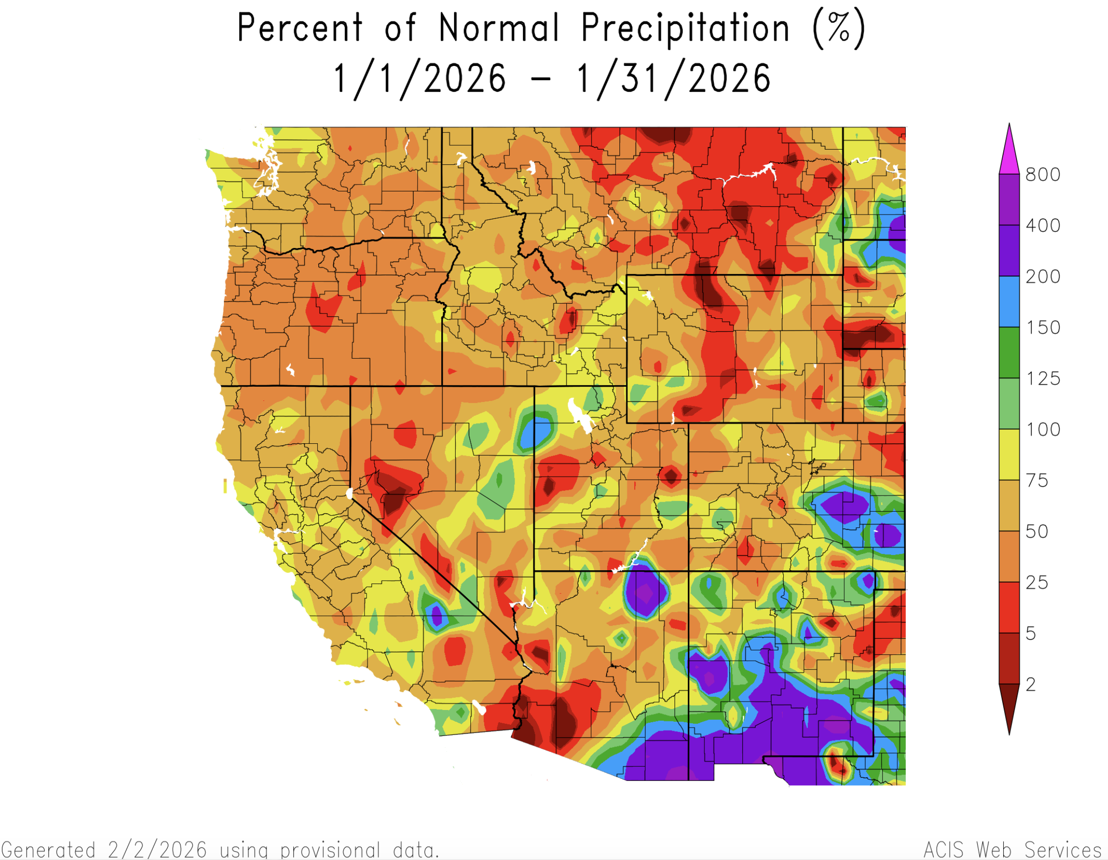
Temperatures were above average across the entire region during January. January temperatures in all of Utah and Wyoming and large portions of Colorado exceeded three degrees above average. Northwestern Colorado, northeastern Utah and western Wyoming observed January temperatures that were six to twelve degrees above average.

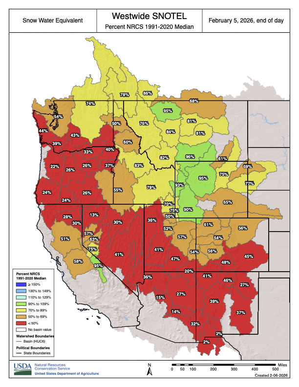
February 1st snowpack conditions were poor across most of the region. Colorado and Utah snow water equivalent (SWE) was 55% of median at the start of February and at record low levels. Snowpack conditions in Wyoming are slightly better with 84% median SWE statewide. Western Wyoming river basins (Bighorn, Green, Snake, and Yellowstone) had near median SWE. Regional snowpack conditions generally deteriorate from north to south with the worst snowpack conditions in the Arkansas, Rio Grande, and San Juan River basins where less than 50% median SWE has accumulated. Real-time estimates of SWE based on satellite imagery suggest significantly poorer snowpack conditions compared to SNOTEL measurements of SWE. These spatial estimates of SWE often differ from SNOTEL SWE measurements because they capture SWE across the entire elevation range while SNOTEL measures SWE across a narrower elevation range. In Utah, February 1 river basin percent SWE varied from 12-54% of average; in Colorado, basin percent SWE ranged from 19-54%; and in Wyoming, basin SWE ranged from 4-110%.

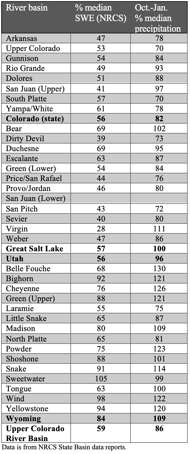

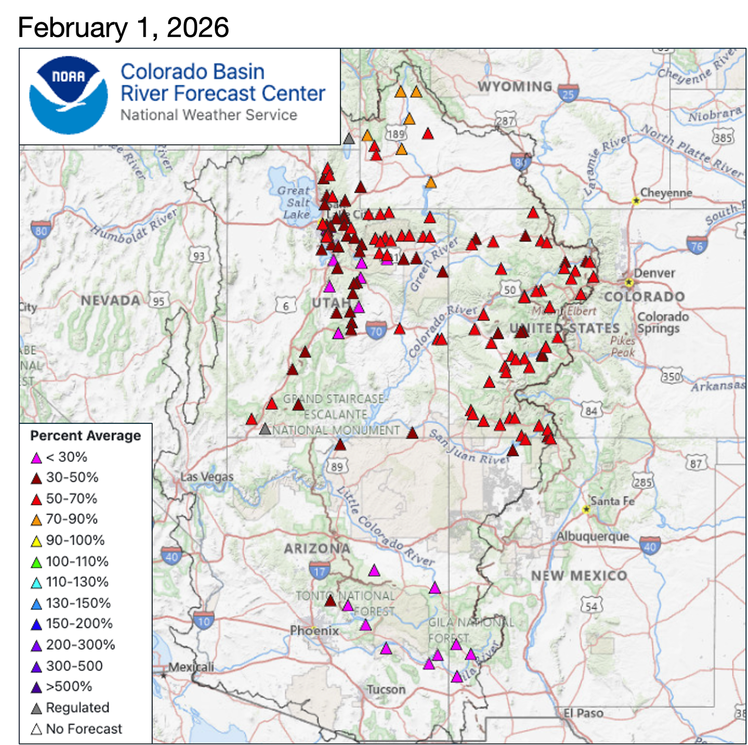
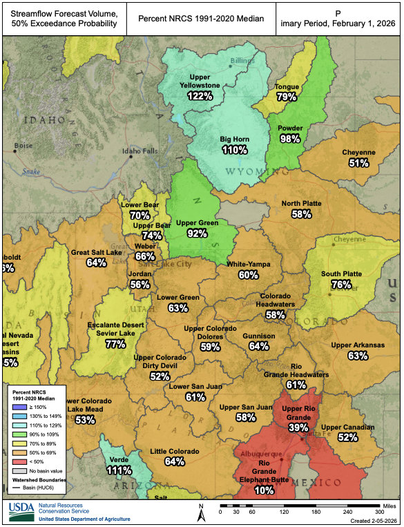
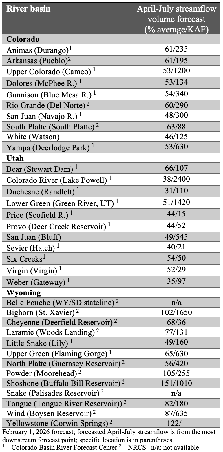
Seasonal streamflow volume forecasts for river basins in Colorado, Utah and southeastern Wyoming are much below average. Near to above average seasonal streamflow volumes are forecasted for much of Wyoming. In the Upper Colorado River Basin, streamflow volume forecasts ranged from 30-92% of average and seasonal inflow volume to Lake Powell is forecasted at 38% of average (2.4 million acre-feet). The Upper Green River Basin and other northern Wyoming basins (Big Horn, Powder and Yellowstone) are forecasted to receive 92-122% of average streamflow volumes. On the Great Basin side of the Wasatch Mountains and Plateaus of Utah, streamflow volume forecasts ranged from 35% of average for the Weber Basin to 54% of average for the Six Creeks watershed in Salt Lake County. Similarly, low streamflow volume forecasts were issued for the Arkansas (63%), Noth Platte (58%) and South Platte (76%) River Basins.

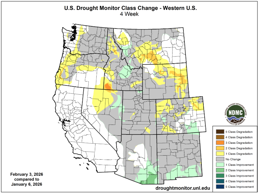
Dry and warm conditions during January caused regional drought coverage to increase to 63% (54% of region on 12/30/25). Drought conditions especially deteriorated in Colorado, where moderate drought emerged in northeastern and southwestern Colorado and severe drought expanded in western Colorado. The area of extreme and exceptional drought in the Colorado River headwaters increased in area during January. Drought emerged in eastern Wyoming and severe drought expanded in the southern portion of the state.

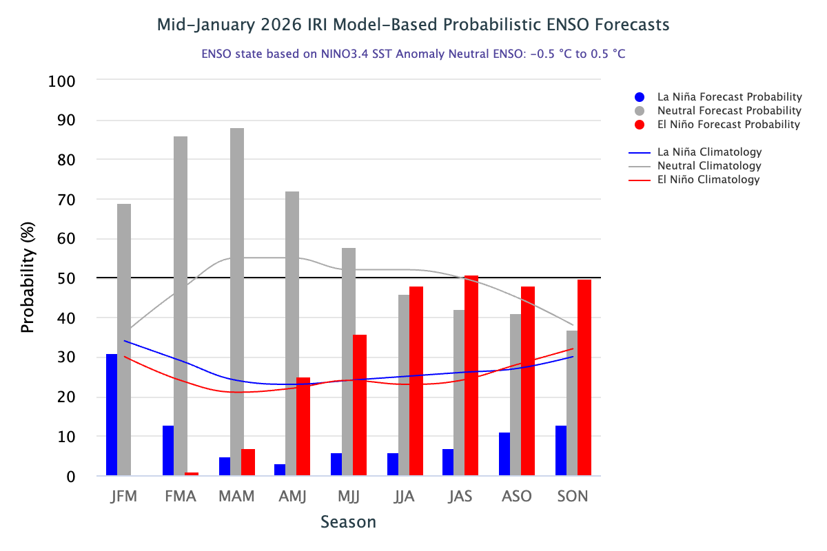
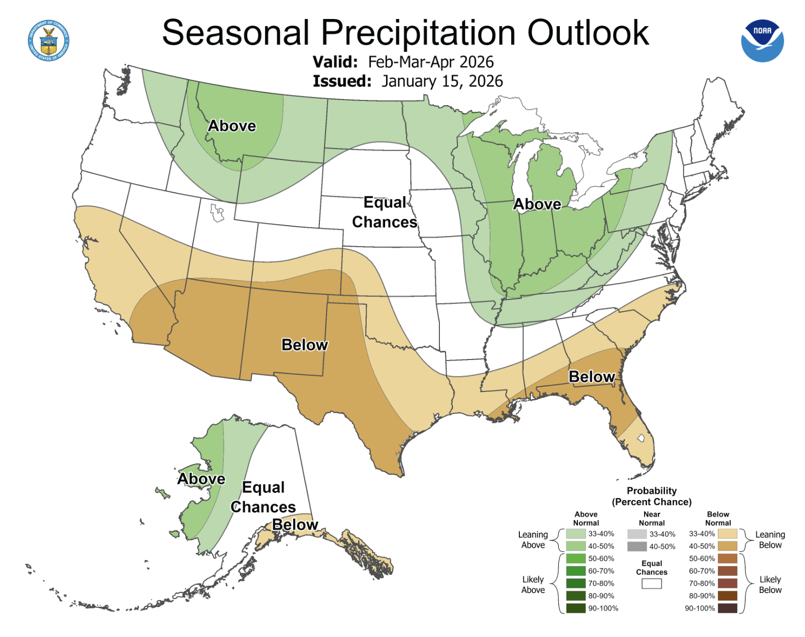
As of mid-January, La Niña conditions persist in the eastern Pacific Ocean. Pacific Ocean conditions are expected to warm and there is a 69% probability of neutral conditions emerging in the next two months. Despite the forecast for warming Pacific Ocean temperatures, ocean temperatures decreased slightly in late January. NOAA monthly forecasts for February suggest an increased probability for below average precipitation across the entire region and above average temperatures for Colorado, Utah and southwestern Wyoming. On the three-month timescale, NOAA forecasts indicate an increased probability of below average precipitation in southern Colorado and southern Utah. February-April temperatures are likely to be above average in Utah and southwestern Colorado.


Significant weather event: Upper Colorado River Basin drought. The Upper Colorado River Basin (UCRB) began the 2026 water year with severe or extreme drought conditions covering nearly the entire watershed. Drought conditions have eased slightly, largely due to a wet October, but basin SWE is currently at 60% of median which is a record low (since 1986). If an average amount of SWE accumulates in the UCRB from February 10 to early April, then the 2026 peak SWE would remain low at 77% of average. Poor snow conditions and relatively dry soils throughout much of the UCRB have resulted in very low (38% of average) Colorado River inflow forecasts to Lake Powell. With a current Lake Powell elevation of 3,535 feet and poor Colorado River streamflow volume forecasts, low reservoir elevations will threaten Glen Canyon Dam’s ability to generate electricity by the end of 2026. The US Bureau of Reclamation’s 24-Month Study projects Lake Powell elevations two years into the future. Under the “Most Probable” scenario, Lake Powell elevation falls to 3,513 feet, just 23 feet above the elevation that the hydroelectricity-generating turbines must be shut down. Under the “Minimum Probable” scenario, reservoir elevations fall to 3,490.6 feet, just inches above the level that power generation at Glen Canyon Dam must cease. Operating Glen Canyon Dam is possible below 3,490 feet, but electrical generation must be bypassed and the alternate outlet for the dam was not engineered to run continuously. With Lakes Mead and Powell sitting at one-third and one-quarter full, only 15 million acre-feet (MAF) of combined water storage exists. However, only 6.3 MAF is available for consumption since nearly 9 MAF of water sits below the deadpool elevation of the reservoirs (Colorado River Research Group, “Dancing with Deadpool“). That means that current accessible storage in the two large reservoirs is less than one year of Lower Basin water deliveries from Lake Powell (7.5 MAF). While the UCRB has faced significant drought challenges over the last 25 years, current and forecasted conditions are taking the basin into truly unprecedented waters.


