
Click the link to read the article on the Yale Climate Connections website (Jeff Masters):
March 11, 2026
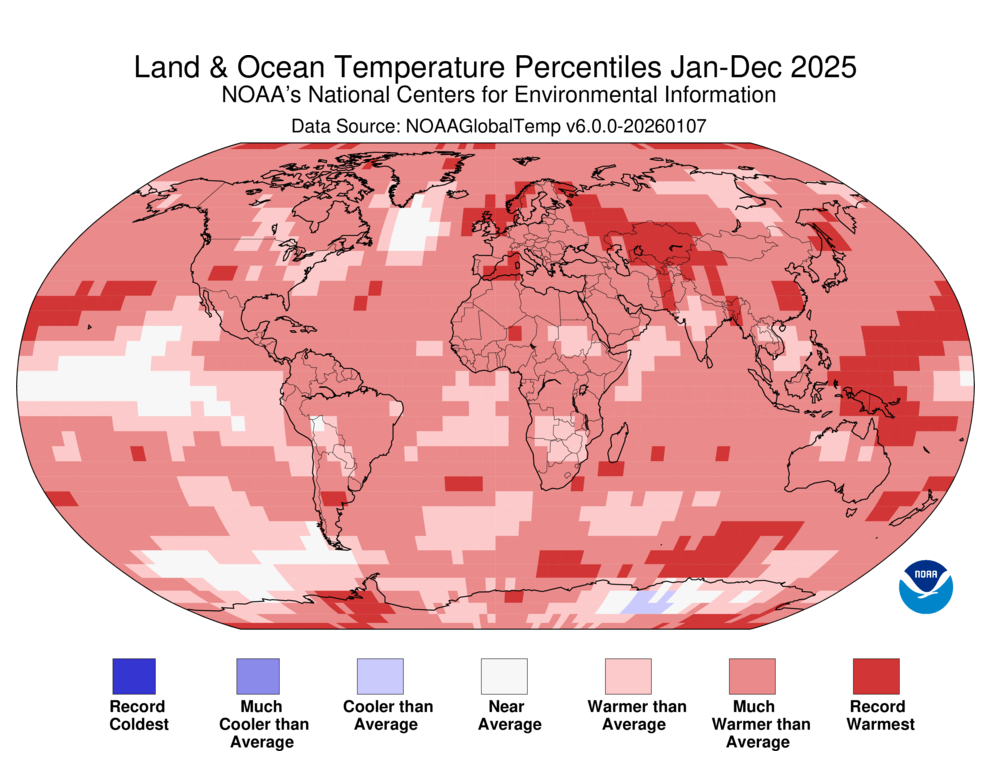
February 2026 was the world’s fifth-warmest February in analyses of global weather data going back to 1850, NOAA’s National Centers for Environmental Information, or NCEI, reported March 11. The European Copernicus Climate Change Service also rated February 2026 as the fifth-warmest February on record, while NASA had it tied for fourth-warmest. The global-average temperature for December 2025 to February 2026 was the fifth-highest on record.
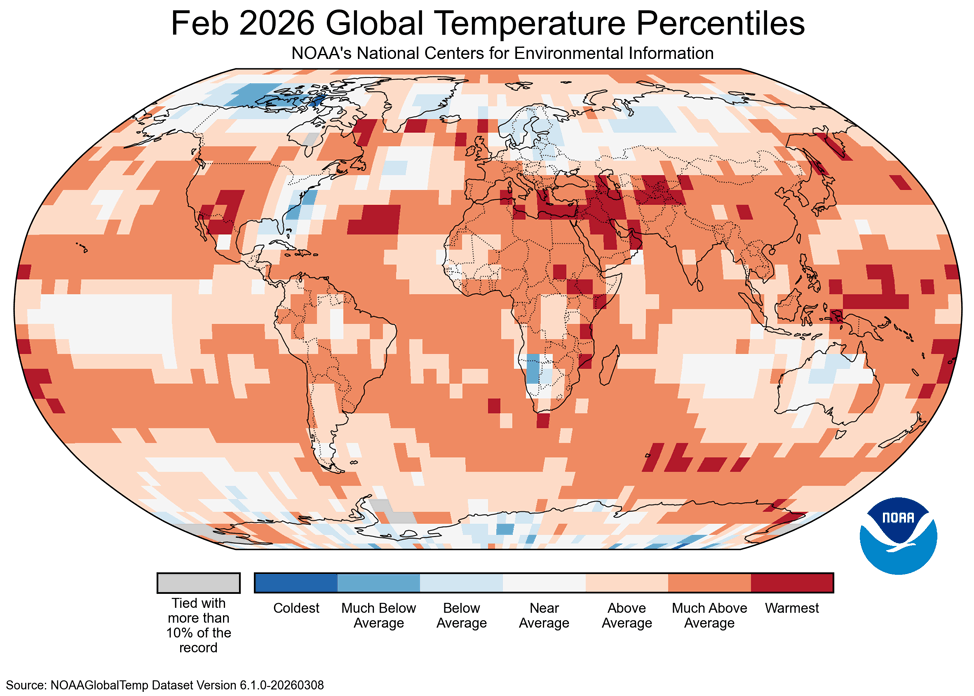
Global land areas had their sixth-warmest February on record in 2026, while global oceans had their second-warmest February, falling just 0.16 degrees Celsius (0.29°F) shy of the record set in 2024, NOAA said. Africa had its second-warmest February, and South America and Asia experienced their seventh- and eighth-warmest February, respectively. While North America, Europe, Oceania, the Arctic, and the Antarctic all experienced above-average February temperatures, none ranked among the top 10.
Snow cover in February was well below average over the Western U.S. and much of Asia and Europe. Overall, Northern Hemisphere snow cover during February 2026 was the third-lowest since records began in 1967.
Warm and dry in the U.S.
As detailed in our post from Tuesday, in the contiguous U.S., winter 2025-26 was the second-warmest and fifth-driest in records going back to 1895. February was the fourth-warmest and fifth-driest February on record. According to the March 5 U.S. Drought Monitor report, about 55% of the continental U.S. was in drought at the beginning of March, up from the 43% coverage at the beginning of the year. Snow-covered area across the Western United States was 38% of the average for February, ranking last in the 26-year satellite record. It was the second month in a row to reach a record low.
An El Niño event looking more likely to develop this year
A weak La Niña event continues in the Eastern Pacific, NOAA reported in its February monthly discussion of the state of the El Niño/Southern Oscillation, or ENSO (the next discussion is scheduled for March 12). La Niña conditions are expected to end in the February-April 2026 period (60% chance), with ENSO-neutral conditions then persisting through August (56% chance). An increasing chance of El Niño conditions is predicted as 2026 progresses, according to the Columbia University International Research Institute for Climate and Society forecast issued February 19. Update: On March 12, in its monthly ENSO discussion, NOAA issued an El Niño Watch; they noted that if El Niño does materialize later this year, there is now a 1-in-3 chance that the event will be a strong one.
The forecast for the August-September-October peak of hurricane season called for a 61% chance of El Niño, a 34% chance of ENSO-neutral, and a 5% chance of La Niña. NOAA is giving a 35% chance of moderate or stronger El Niño conditions if an El Niño event develops. El Niño conditions tend to suppress Atlantic hurricane activity through an increase in wind shear, but La Niña conditions tend to have the opposite effect. The most recent ENSO forecast from the European model was very bullish on a significant El Niño event developing by late spring or summer and continuing through at least fall 2026.
Last month, NOAA switched to using the Relative Oceanic Niño Index, or RONI, as its standard ENSO monitoring tool. This tool uses sea surface temperatures across the tropics to adjust the Oceanic Niño Index, making it a better gauge of how ENSO is expressed in a warming climate.
Read: A new and better way to keep tabs on El Niño
Arctic sea ice: third-lowest February extent on record
Arctic sea ice extent during February 2026 was virtually tied with February 2017 as the third-lowest in the 48-year satellite record, behind only February 2025 and February 2018, according to the National Snow and Ice Data Center. Overtopping this depleted ice was an atmosphere more frigid than the recent norm, as the Arctic had its 45th warmest February since 1850 – but the coldest since 2009.
Antarctic sea ice extent in February 2026 was near the long-term average, ranking as the 21st-lowest in the 48-year record. The Antarctic had above-average temperatures in February, ranking as the 13th-warmest since 1850. Antarctic sea ice reached its minimum extent for the year, at 2.58 million square kilometers (996,000 square miles) on February 26, 2026, ranking 16th-lowest in the 48-year satellite record.