Early season snowpack falls short across the West — The High Country News

From The High Country News (Paige Blankenbuehler):

On April 1 this year, a snow survey in California’s Sierra Nevadas near Echo Peak had to be conducted on bare grass — an unprecedented April Fool’s joke from Mother Nature. Fast forward to December, and the same area has had modest improvement — now 53 percent of normal — but go just south near Sequoia National Park, and snow survey sites are buried, reporting nearly 200 percent snowpack for early winter. Farther south still, the change is dramatic; sites in the Central Valley that would typically be measuring a few centimeters by now, haven’t seen any snow.

And that pattern is holding up across the West. Taken as a whole, Western snowpack measurements in early December paint a widely varied picture — some places are far above historic normals, while others are still far below. For watersheds, that means things are looking better than they have been, but we’re not out of the woods yet.

According to the Natural Resources Conservation Service’s SNOTEL sites, which measure snow depth at thousands of stations nation-wide, only two Western states — Nevada and Idaho — are above the historic benchmark for “normal” at this time of year.

Click here for the data.

Nevada, Idaho, Alaska and Colorado have had nearly normal to above normal snowpack readings so far, according to state data compiled by SNOTEL. The states’ overall averages, however, can be misleading, Haynes says. It’s important to look at where the snow is falling in the states. As long as precipitation is falling within important watersheds for municipal water supply, areas that have been dry will still benefit from more fortunate areas. In Colorado, the Rocky Mountains, which provide water for the bulk of the state’s urban population, have had above normal early season snowpack readings, but a cluster of low readings near the Gunnison National Forest on the Western slope have brought the state’s average just slightly below normal.

So far, Montana is lagging for early season snowpack in the West. The state has the lowest reading in the region — only 73 percent of the historic average. In Nevada, much of the state is experiencing the opposite. The state’s average snowpack readings are 117 percent of normal, and much of the early winter precipitation has fallen in the western edge of the state near Truckee and Tahoe, which bodes well for reservoirs in neighboring California.

Other parts of the region are beginning to see problems from too much early season snow. Snowpack readings in the Pacific Northwest are above normal and at lower elevations above-normal rainfall is predicted. NOAA is telling residents to prepare for flooding through the Bellingham, Seattle, Olympia and Yakima areas for the remainder of December. Already, numerous highways have been closed from landslides and floods in Washington, and a woman in Oregon drowned after her vehicle was submerged in a flood about 60 miles northwest of Portland.

And of course, the question remains: When will El Niño show up? The weather anomaly, as High Country News reported recently, is set to impact most heavily parts of Southern California and the Pacific Northwest, with higher precipitation and warmer temperatures. Since the first week of November, the Sierras have been in a cycle of storms that have brought snow each week. “It’s impossible to tie one storm — or even a series of storms — to El Niño. It’s too bold to say these storms are a symptom of that phenomenon,” says Randall Osterhuber, a research at the UC Berkeley Central Sierra Snow Lab.

But overall, NOAA long-range forecasts call for above-average snowfall for Southern California, Haynes says. In Colorado, Nevada, Idaho and Washington, the bulk of winter precipitation is expected in January through March. Osterhuber says late season flurries that maintain snowpack through the spring months are crucial across the region. “When snowpacks don’t even make it to mid-March, that’s a huge problem,” he says. “California has tremendous demands on its water resources, and we rely on the Sierras. After four years of miniscule snowpack, we need this.”

Click on a thumbnail graphic below to view a gallery of snowpack data for Colorado from the Natural Resources Conservation Service.

My World Interrupted — Esau Sinnok #COP21

From the Department of Interior (Esau Sinnok):

Close your eyes and picture your best memory with your family and friends. If you’re like me, that memory is filled with the warmth and comfort of a familiar home. I hope that, unlike me, you are never asked to put a price on that home because of the effects of climate change.

EsauSinnokshishmarefakviadoi

Welcome to Shishmaref, Alaska, population: 650. We’re a small Iñupiaq community where everyone knows each other. Shishmaref is a barrier island that has been eroding and flooding for the past 50 years — even before disruption from climate change was widely recognized.

Over the past 35 years, we’ve lost 2,500 to 3,000 feet of land to coastal erosion. To put this in perspective: I was born in 1997, and since then, Shishmaref has lost about 100 feet. In the past 15 years, we had to move 13 houses — including my dear grandma Edna’s house — from one end of the island to the other because of this loss of land. Within the next two decades, the whole island will erode away completely.

shismarefakviadoi

During my lifetime, I’ve seen unusual weather patterns that villagers have never witnessed before. It rained during winter last year and ice formation is coming later in the year. My grandfather remembers when 30-35 years ago ice used to form fully in late September or the middle of October. It is December, and the ice barely formed enough for us to safely cross it.

The lack of ice has affected our hunting, fishing and other traditions. We use handmade wooden boats to hunt and fish in the surrounding areas of Shishmaref as well as snowmachines to get around in the winter time. Every year it gets harder and harder to collect enough meat for the winter. Tomcod and whitefish are a large part of our winter diet, but since the ice forms later in the year, it’s more difficult for us to gather enough food.

icefishingshishmarefakviadoi

Our village is so remote that it is only accessible by airplane, and we only get fresh food products from other parts of Alaska every one to two months. If we can’t hunt and fish to feed ourselves in the winter, we will starve.

In 2001, my people voted to relocate along the coast of mainland Alaska, but the estimated cost is $200-250 million. The reality of moving is very complicated. There is not enough funding for relocation efforts. And even though we made this decision, everyone wants to stay — especially the older generations who have spent their whole lives in Shishmaref.

But we realize we have no choice. It really hurts knowing that your only home is going to be gone, and you won’t hunt, fish and carry on traditions the way that your people have done for centuries. It is more than a loss of place, it is a loss of identity. Once you see how vulnerable my community is to sea-level rise and erosion, you won’t be able to deny that Arctic communities are already feeling the impacts of climate change.

shishmarefakaerialviadoi

Despite this reality, I appreciate every day that I get to wake up and see the scenery that’s still here and that I’m able to call this place home. For now. While it’s too late to save the island of Shishmaref, we still have a little bit of hope that we’ll be able to preserve our traditions and stay united as a culture.

That’s why I am determined to speak up for my community.

This year, I became an Arctic Youth Ambassador — a program started by the Interior and State Departments in partnership with Alaska Geographic. It gives Alaskan youth the chance to share our perspectives on issues in our communities. As an ambassador, I not only attend the Arctic Council meetings, but I’m also invited to travel with the Arctic Council.

This week, I am in Paris, France, for the United Nations climate talks. It’s only the second time in my life that I have left Alaska, and it’s been a powerful experience. This week, I met with Secretary Jewell and other indigenous people. This meeting gave me insight into how issues of the Arctic and climate change are being handled by our world leaders.

indigenouspeoplecop21viadoi

My reason for attending the 21st Conference of Parties in Paris — COP21 — is to tell leaders that climate change is affecting the Arctic more than other places of the world, and if the ice in Greenland melts, these villages and islands will be under water.

I hope that world leaders will hear my message and rise to the challenge because it is not just a political issue to me. It’s my future.

Nat Geo Show To Feature Water Expert’s Work In #ColoradoRiver Basin — KJZZ

From KJZZ:

As the result of a binational agreement between the United States and Mexico, the Colorado River received a pulse flow of water in spring 2014 that once again connected the river to the Gulf of California.

Conservationist Sandra Postel’s continued work in the Colorado River delta will be profiled this weekend on the new National Geographic show “Breakthrough.”

Postel is the founder of the Global Water Policy Project. She first visited the Colorado River delta in 1996.

“And at that point, we really sort of had the impression the Colorado delta was dead,” Postel said.

The overstretched river had long stopped short and left a dry channel. But scientists found if water could be returned to the area, the habitat could come back.

Many conservation groups are working to provide water to the once-again living delta. Following the 2014 pulse flow, the Colorado River Delta Water Trust leases water from farmers in the river basin to supply part of what’s called base flow — the continuous, low amount of water required to support the delta’s plants and animals.

Postel created a campaign, “Change the Course,” which engages the public and gathers corporate donations for these restoration efforts.

“At this point we have 140,000 people in our pledge community, which means we’ve returned 1,000 gallons of water for each of those pledges,” Postel said.

The Colorado River project is a pilot for “Change the Course,” and Postel plans to apply the fundraising model to other watersheds.

Postel’s work in the Colorado River basin will appear Dec. 13 at 7 p.m. on the National Geographic Channel.

Nature, Not Humans, Has Greater Influence on Water in the #ColoradoRiver Basin

The Colorado River supplies water to Lake Mead, the largest man-made reservoir in terms of capacity in the United States. New research from The University of Texas at Austin has found natural variability, not humans, have the most impact on water stored in the river and the sources that feed it. U.S. Geological Survey

From the University of Texas (Anton Caputo/Monica Kortsha):

Researchers have found that the water supply of the Colorado River basin, one of the most important sources for water in the southwestern United States, is influenced more by wet-dry periods than by human use, which has been fairly stable during the past few decades.

The study, led by The University of Texas at Austin, took the most comprehensive look to date at the state of a water source that serves 40 million people in seven states. The researchers used 30 years of local water monitoring records and more than a decade of data collected from the NASA satellite system GRACE to reconstruct changes in the basin’s water storage since the 1980s.

The Colorado River Basin is divided into upper and lower portions. It provides water to the Colorado River, a water source that serves 40 million people over seven states in the southwestern United States. Colorado River Commission of Nevada

The team found that water storage decreased by 50 to 100 cubic kilometers (enough water to fill Lake Mead as much as three times) during droughts that occur about every decade. The big difference between recent and previous droughts is that there have been few wet years since 2000 to replenish the water. In contrast, multiple wet years followed drought years in the 1980s and 1990s.Scientists from the U.S. Geological Survey, NOAA, UT Center for Space Research, the Arizona Department of Water Resources and Tsinghua University were part of the team. The findings were published online in Water Resources Research Journal on Dec. 10.

Researchers also found that total water storage changes are controlled mostly by surface reservoir and soil moisture changes in the upper basin, with additional reductions in groundwater storage in the lower basin that mostly reflect natural responses to wet and dry climate cycles and irrigation pumping in areas without access to Colorado River water.

“This study explains how the system works, what’s important and what to look out for,” said lead author Bridget Scanlon, a senior research scientist at the Bureau of Economic Geology. “The upper basin is critical. Eighty percent of the runoff in the basin comes from the upper basin, so the climate of the upper basin is really important.”

The bureau is a research unit of The University of Texas at Austin’s Jackson School of Geosciences.

Water is stored in the Colorado River Basin as snow, soil moisture, reservoir water and groundwater. The on-the-ground measurement data helped the researchers understand where and how water was stored, and the GRACE satellite data gave insight into the total water storage in the basin.

Launched in 2002, the GRACE satellite measures changes in total water storage in an area by monitoring fluctuations in the Earth’s gravity field, a value that is influenced by the presence of water.

“GRACE gives us a holistic view on a large scale about variations in total water storage including snow, reservoir, soil moisture and groundwater storage,” said Scanlon. “We need to use those data along with as much ground-based data as we can access to understand where the storage changes are occurring in the system.”

William Alley, director of science and technology at the National Ground Water Association, said the study is an important example of supplementing GRACE data with on-the-ground research.

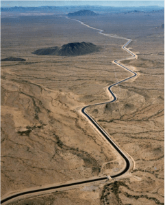
The Central Arizona Aqueduct delivers water from the Colorado River to underground aquifers in southern Arizona. UT researcher Bridget Scanlon recommends more water storage projects like the aqueduct to help protect against variability in the river’s water supply. U.S. Bureau of Reclamation.

“Overall, this paper makes a much needed contribution by demonstrating the importance of supporting GRACE data with a thorough hydrologic analysis,” Alley said. “The authors pull together an impressive array of hydrologic data in conjunction with GRACE data to examine natural and anthropogenic influences on water storage in the basin and its basic components.”

Scanlon said that this research underscores the importance of saving water in rainy years for the droughts that historically have followed. Whereas most water was stored in surface reservoirs in the past, primarily lakes Mead and Powell, Arizona has been storing much of its allocation of Colorado River water in underground aquifers since the Central Arizona Project aqueducts were completed in the early 1990s. Scanlon said the research should encourage more storage projects.

“We need to manage this variability of supply,” she said. “And we do it by storing water in surface and subsurface reservoirs.”