From The Pueblo Chieftain (Gayle Perez):
The frigid temperatures were ushered in with Thursday’s storm that dumped 6.6 inches of snow at the Pueblo Memorial Airport by Friday afternoon, according to Larry Walrod, a lead forecaster with the National Weather Service. “Most areas around Pueblo saw 3 to 4 inches of snow, while Pueblo West had 2 to 3 inches,” Walrod said.
Snow accumulations elsewhere in the region ranged from 1 to 2 inches near Trinidad and Lamar to 2 to 4 inches around La Junta.
Here’s a look at the NRCS’ efforts to measure snowpack and predict runoff, from Janice Kurbjun writing for the Summit Daily News. From the article:
[Mike] Gillespie and [Chris Pacheco] are the Denver-based snow survey supervisor and assistant supervisor with the Natural Resources Conservation Service. They have been doing snow surveys for 30 years, but the process — and its resulting data — has been of importance for more than a century in the West. It all started in the Lake Tahoe area, Pacheco said, where Dr. James Church realized that part of a solution to the ongoing water wars was to predict how the lake would rise each spring. In 1904, he established a snow course and began gathering data. Some of the first runoff forecasts were established in 1910 as text-based pamphlets that were mailed out to interested parties. “The western United States relies on snowpack for about three-quarters of its water,” Pacheco said. “As demand for water increases, there’s more of a need to understand the content of the snowpack … It’s a vital part of living in the West.”[…]
Municipalities and reservoir operators are also among those seeking information gleaned from the surveys, which includes snowpack depth and snow water content. The information is further synthesized into broader streamflow forecasts…
The Berthoud Pass manual snow survey is the first of the 2011 season, giving the first glimpse of what water availability will be in 2011, Gillespie said. It kicks off a set of more than 100 monthly manual measurements from January to May across Colorado. They’re performed by about 50 field personnel with offices in each Colorado county. The manual survey network nearly doubles the automatic SNOTEL system of about 110 sites, which take hourly measurements each day. The SNOTEL sites are generally higher in elevation and more difficult to get to than the manual reading sites, Pacheco said. Maintaining manual readings helps defray costs of expensive SNOTEL equipment as well as provides a way to verify automatic data.
When averaged, Thursday’s Berthoud Pass measurements largely matched the day’s automatic readings at the site. Pacheco said the snow depth was 40 inches, and the snow-water content was 10.5 inches. That’s compared to 36 inches and 9.3 inches, respectively, from the SNOTEL. Both data sets show the snow has a density of 26 percent, he said…
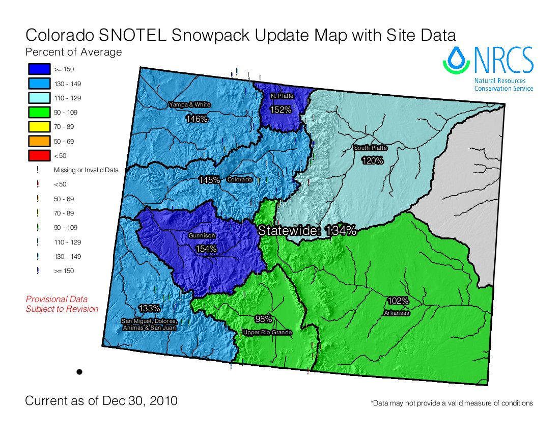
According to SNOTEL information, the statewide snowpack is at 134 percent of average. In the Colorado River Basin, it’s at 145 percent of average, while the Arkansas River Basin is at 102 percent of average…
“The northern part of the state has been above average almost since the get-go,” Pacheco added.
From the Cortez Journal (Reid Wright):
Ten inches were reported in Cortez, just shy of a 1969 record 24-hour storm that dumped 11 inches on Cortez, making it the 20th biggest snow storm on record, said Joe Ramey, a meteorologist with the National Weather Service in Grand Junction…
The wet month, at 230 percent of normal precipitation, comes at the end of a three-year trend of wet Decembers. December 2009 saw 170 percent of normal precipitation, December 2008 saw 212 precent of normal, and December 2007 saw 278 percent of normal.
Like this:
Like Loading...


