National Climatic Data Center: November State of the Climate report #CODrought #COwx

monthlysignificanteventsnoaamap112012.jpg

Here’s the November State of the Climate from NOAA’s National Climatic Data Center:

Drought persists, causing water resource issues for central U.S.; 2012 virtually certain to become warmest year on record for the nation

The average temperature for the contiguous U.S. during November was 44.1°F, 2.1°F above the 20th century average, tying 2004 as the 20th warmest November on record. The autumn contiguous U.S. temperature of 54.7°F was the 21st warmest autumn, 1.1°F above average.

The November nationally-averaged precipitation total of 1.19 inches was 0.93 inch below the long-term average and the 8th driest November on record. The autumn precipitation total for the contiguous U.S. was 5.71 inches, 1.0 inch below average.

The January-November period was the warmest first 11 months of any year on record for the contiguous United States, and for the entire year, 2012 will most likely surpass the current record (1998, 54.3°F) as the warmest year for the nation.

U.S. climate highlights: November

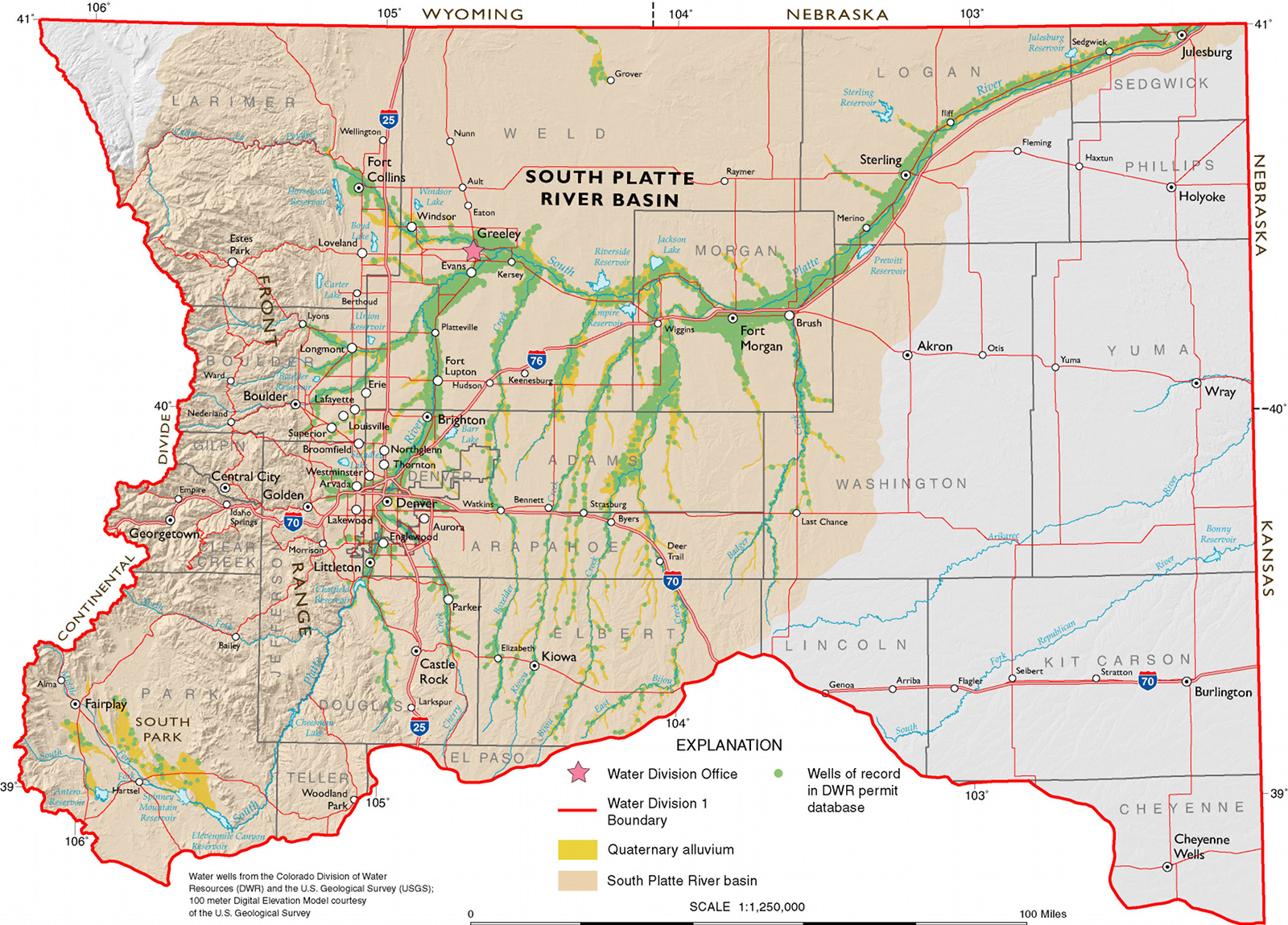
  • November brought warmer-than-average conditions to the western half of the country. The largest temperature departures from average were centered near the Rockies where Arizona, Colorado, New Mexico, Utah, and Wyoming had November temperatures among their ten warmest.
  • The Eastern Seaboard, Ohio Valley, and Southeast were cooler than average during November. North Carolina tied its 10th coolest November on record, with a statewide-averaged temperature 3.5°F below average.
  • A large area of the country experienced below-average precipitation in November. Drier-than-average conditions stretched from the Intermountain West, through the Plains, into the Midwest, and along the entire East Coast.
  • Twenty-two states had monthly precipitation totals ranking among their ten driest.
  • According to the November 27 U.S. Drought Monitor report, 62.7 percent of the contiguous U.S. was experiencing moderate-to-exceptional drought, larger than the 60.2 percent observed at the end of October. Drought conditions improved for parts of the Northern Rockies, which were wetter-than-average during November, while conditions worsened for parts of the Southwest and Mid-Atlantic.
  • U.S. climate highlights: Autumn (September-November)

  • Autumn temperatures were above average across much of the western United States. Nevada had its warmest autumn on record, with a seasonal temperature 3.7°F above average. Arizona, California, Idaho, New Mexico, Utah, and Wyoming each had a top ten warm autumn.
  • The Ohio Valley and Southeast experienced below-average autumn temperatures. Kentucky autumn temperatures were the sixth coolest while Mississippi had its 10th coolest autumn.
  • Autumn precipitation totals were drier than average for the central U.S. and parts of the Southeast. Minnesota, Nebraska, and South Dakota each had a top ten dry autumn. Wetter-than-average conditions were present for the Pacific Northwest, the Ohio Valley, and parts of the Northeast.
  • U.S. climate highlights: Year-to-Date (January-November)

  • The January-November period was the warmest first 11 months of any year on record for the contiguous United States. The national temperature of 57.1°F was 3.3°F above the 20th century average, and 1.0°F above the previous record warm January-November of 1934. During the 11-month period, 18 states were record warm and an additional 24 states were top ten warm.
  • It appears virtually certain that 2012 will surpass the current record (1998, 54.3°F) as the warmest year for the nation. December 2012 temperatures would need to be more than 1.0°F colder than the coldest December (1983) for 2012 to not break the record.
  • January-November 2012 was the 12th driest such period on record for the contiguous U.S., with a precipitation total 3.08 inches below the long-term average of 26.91 inches.
  • Drier-than-average conditions stretched across the central part of the country, from the Rocky Mountains to the East Coast. Colorado, Nebraska, and Wyoming each had their driest year-to-date on record and eight additional states had 11-month precipitation totals among their ten driest.
  • Wetter-than-average conditions were present for the Pacific Northwest, the central Gulf Coast, and New England. Washington State experienced its 9th wettest year-to-date.
  • The U.S. Climate Extremes Index (USCEI), an index that tracks the highest and lowest 10 percent of extremes in temperature, precipitation, drought and tropical cyclones across the contiguous U.S., was more than twice the average value during the January-November period, and marked the highest USCEI value for the period. Extremes in warm daytime temperatures, warm nighttime temperatures, and the spatial extent of drought conditions contributed to the record high USCEI value.
  • Colorado State University Scientists Studying Climate Change Impact on Front Range Drinking Water through USDA Grant

    southplatteriverbasincgs.jpg

    Here’s the release from Colorado State University (Jennifer Dimas):

    The Colorado Rocky Mountains are undergoing rapid changes as the result of climate change. Through a new United States Department of Agriculture grant, Colorado State University scientists and the U.S. Forest Service are investigating how those changes will impact drinking water for the millions living along Colorado’s Front Range.

    Through the $125,000 USDA grant, postdoctoral researcher Gina McKee and associate professor Thomas Borch from CSU’s Department of Soil and Crop Sciences, along with Chuck Rhoades from the U.S. Forest Service, will study the potential impact of climate change on water quality affecting more than 25 million who rely on the forest’s headwaters as their drinking water source.

    “This research will provide critical information about the future quality of drinking water consumed by millions along the Front Range of Colorado and beyond,” said McKee. “I am thrilled to receive this prestigious award from the USDA NIFA postdoctoral grant program. The opportunity to conduct this cutting-edge research at CSU investigating the impact of climate change on water quality is a real honor.”

    Due to increased temperatures from climate change, Colorado’s mountain pine beetle infestation has killed approximately 10 million lodgepole pine trees since 2006. The collaborative project between CSU and the U.S. Forest Service will apply advanced analytical techniques for the first time to determine what the vegetation change in the Rocky Mountains means for the water produced along the Front Range. The change in vegetation could have a dramatic impact on the chemistry and quantity of natural organic matter (NOM) in forest headwaters which in turn affects water quality.

    One unique aspect of the project is the advanced analytical techniques the team will use: primarily ultrahigh resolution mass spectrometry. Using this advanced technique, researchers will investigate the impact vegetation change has had on the recovering subalpine forests using a list of biological markers (biomarkers) from the major vegetation types for comparison.

    The biomarkers will be used as a tracing tool for each vegetation type in surrounding soils and waters to assess the significance of the vegetation change. Additionally, the scientists will look at the released NOM from subalpine forests as they enter the headwaters and then on as the source of drinking water for millions. This NOM reacts with disinfectants – such as chlorine – added during drinking water treatment to produce carcinogenic compounds called disinfection byproducts that can be carried to peoples’ homes. The formation of the toxic disinfection byproducts is a global issue potentially affecting millions of people worldwide, and therefore is of great concern.

    The molecular makeup of the NOM precursor compounds is poorly understood which limits the ability of drinking water facilities to effectively remove them and will be further compounded if this NOM is altered due to the changes in vegetation.

    “This project will provide new information that can be used to optimize current drinking water treatment approaches in order to minimize the formation of carcinogenic drinking water pollutants,” said Borch.
    During the study, headwaters will be subjected to model drinking water treatment to identify whether vegetation type impacts the formation and quantity of disinfection byproducts and what the likely NOM precursor compounds are. The results could have wide-ranging impacts on millions of people’s ability to obtain high-quality drinking water in light of the changing headwater chemistry.

    McKee, Borch and Rhoades will spend the next two years studying the effect of NOM derived from major headwaters and specific vegetation types on the formation of drinking water pollutants.

    More education coverage here.

    CoCoRaHS webinar: Historic Winter Season Weather Events — What’s the best of the worst

    Western Governors Association report: Water Transfers in the West

    watertransfersinthewestwesterngovernorsassociation122012.jpg

    You can download a copy here. Here’s the release (Tom Iseman/Tony Willardson):

    The Western Governors today released a report, Water Transfers in the West, which provides an overview on how the region can help meet growing demands for water with voluntary market-based sales and leases of water rights.

    “Voluntary water transfers have occurred for decades,” said Governor Gary R. Herbert (Utah), Chairman of the Western Governors’ Association. “But with so many new citizens and industries settling in the water-scarce West, now is the time to evaluate how we use transfers in our approach to providing water.”

    A water transfer, as defined in this report, is a voluntary agreement that results in a change in the type, time or place of use of a water right. Water transfers can take the form of a sale, lease or donation and they can move water among agricultural, municipal, industrial energy and environmental uses.

    Water transfers are one component of a suite of tools Western water managers can use to meet new demands from changes in farming practices, energy development, and urbanization. States can also develop new infrastructure and storage (such as dams), conservation and efficiency, and water reuse projects.

    “There is no magic wand or silver bullet when it comes to meeting water supply, only well-informed decision making,” said Jennifer Gimbel, Director of the Colorado Water Conservation Board. “This report will help states learn from each other’s experiences with water transfers in order to make the best decisions for each state’s water future.”

    Water transfers offer a means to “re-purpose” existing water resources for new uses. Since farmers hold many of the West’s senior water rights, the Governors passed a policy in 2011 advocating that states “identify and promote innovative ways to allow water transfers from other uses … while avoiding or mitigating damages to agricultural economies and communities.” The report also addresses ways to mitigate impacts to the environment.

    The report is a product of a year-long project in partnership with the Western States Water Council (WSWC), a group of top water administrators in the Western states. The Western Governors’ Association and WSWC convened three stakeholder workshops with more than 100 participants from July to December of 2011. The meetings drew state administrators, environmental organizations, farmers, academics, and water resource professionals from across the West, providing diverse perspectives on water transfers.

    “The balanced approach to water transfers advocated for in the WSWC report is the same philosophy that must be advanced on an even larger scale here in the West,” said Patrick O’Toole, President of the Family Farm Alliance and a workshop participant. “Transfers are a way of meeting short-term water challenges, but they are only one instrument in a much broader suite of tools that also must include water conservation and modern infrastructure to store and move water.”

    Rather than providing a “one-size-fits-all” blueprint for states to follow, Water Transfers in the West highlights successful transfers and innovative practices to allow Western states to learn from their collective experiences and take advantage of the “lessons learned.” The report also recognizes that each state’s individual circumstances will determine how it should address transfers. It addresses only transfers within states, and not interstate transfers.

    “Transfers are already occurring in all of the Western states, and many state water administrators say that transfers will continue to play a vital role in the way they meet demands,” said Tony Willardson, Executive Director of the Western States Water Council (WSWC). “WSWC and WGA will continue to provide states with information on how to take advantage of the decentralized and flexible nature of transfers while avoiding or mitigating any negative effects of transfers.”

    WGA and WSWC will continue their work on water transfers following the release of the report.

    The report, titled Water Transfers in the West: Projects, Trends, and Leading Practices in Voluntary Water Trading is available for download online at westgov.org/water. Information from past stakeholder workshops, an executive summary, and perspectives from stakeholders are also available online.

    More water law coverage here.

    Grand Junction: Sanitary sewer rates are going up in 2013

    historicdowntowngrandjunction.jpg

    From The Grand Junction Daily Sentinel (Duffy Hayes):

    It’s been a few years since customers of the Persigo Wastewater Treatment Plant have seen their monthly bills rise, but plans for each of the next three years call for a boost in customer fees.

    A budget adopted this week for 2013 includes a $2.02 rise for basic, minimal-use sewer and wastewater treatment service for Persigo customers, increasing the total monthly service to $17. According to the plan, rates are set to jump $2 in 2014 and $1.75 in 2015.

    Mesa County commissioners, who have joint oversight over the wastewater plant with the Grand Junction City Council, heard a number of reasons for the planned rate increases.

    Grand Junction City Services Manager Dan Tonello presented a budget for next year that includes a roughly 3 percent increase in operations expenses and a capital plan that is jumping from $2.29 million in 2012 to $4.22 million in 2013.

    A big part of the additional expense is to replace aging infrastructure in the system’s collection network. Tonello said 217 miles of the roughly 500 miles of pipe in the system are at “life expectancy” and “beyond their design life.”

    “We need to increase the frequency with which we are replacing that — or essentially, 10 or 20 years down the road, we could have a very old system in need of drastic repairs,” Tonello told county commissioners.

    Persigo plans to hire two new full-time employees next year. One is expected to help maintain and repair the current system. Another is expected to help serve the Central Grand Valley Sanitation District, which Persigo now manages after a November vote that dissolved the special district.

    Also, because there have been no rate increases during the recent economic downturn, Persigo fund balances have decreased, and Tonello said the rate increases will keep those balances above minimally acceptable levels.

    Finally, regulations that will require new measurement of nutrients are looming. About $500,000 is being set aside next year to prepare for those regulations, and Persigo hopes to have $11 million collected by 2023 to comply with the new, as-of-yet unspecified standards.

    “I’m not real happy about the increase in fees, but I do understand the challenges with capital and maintaining the infrastructure, and I do know that we have one of the smallest monthly fees compared to any other sewer funds,” Commissioner Janet Rowland said.

    Despite the fee increases, Persigo customers still enjoy the lowest rates on the Western Slope for sewer service. Staff attribute the low fees to federal participation in Persigo’s construction in the 1980s and the lack of a debt payment for the plant.

    Looking beyond 2015, the long-range budget projections show no increase in fees in 2016 and 2017, and 50-cent increases planned for 2018, 2019 and 2020. Tonello cautioned that these are very preliminary projections for these years and “when we actually get there, things could be very different.”

    More infrastructure coverage here.

    Animas River: ‘The amount was 9,209 acre-feet, the lowest total in 102 years’ — The Durango Herald #CODrought

    animasriveratdurangonovember2012.jpg

    Click on the thumbnail graphic for the discharge graph for November for the Animas River at Durango gage.

    From The Durango Herald:

    The flow, given in acre-feet, was the total amount of water that flowed past the Durango gauging station in 30 days. The amount was 9,209 acre-feet, the lowest total in 102 years. The rate of flow, which is measured in cubic feet per second and reflects the amount of water passing by a fixed point every second, wasn’t great, either. It varied from a minimum of 133 cfs to a maximum of 176 cfs…

    The second-lowest total flow in the Animas River at Durango during November was in 1934 when 9,374 acre-feet was recorded.

    From The Telluride Daily Planet (Collin McRann):

    At the end of a year that saw a dry spring and early summer, Telluride has fallen way behind average for annual precipitation. According to records kept by resident Thom Carnevale, Telluride saw 15.42 inches of precipitation for the year through Nov. 30 — about six and a half inches below the average to-date number of 21.73 inches. November saw just .39 inches of precipitation, down from the monthly average of 1.53 inches.

    Though the year might be a wildcard in terms of snowfall, over the past 62 years, warm weather in the region — which meteorologists are predicting — has traditionally not been good for snowfall.

    “Based on research done by Joe Ramey, here in Western Colorado, even though the Climate Prediction Center is predicting equal chances for either above or below average precipitation — chances are it will be dry,” said Jim Pringle, a meteorologist at the NOAA’s Grand Junction office. “Since 1950 when we’ve had significantly dry periods, a good number of them were during neutral sea patterns — there are only a couple of years where there are exceptions.”[…]

    According to data from NOAA, most of San Miguel County has only received around 25 to 50 percent of average precipitation for the year, and the entire county is considered to be in severe drought, which it has been since early summer. Over the last month, most of the county has received 0 percent of the precipitation it got a month earlier.

    Powder Day! Breckenridge = 8″, Beaver Creek = 11″, Vail = 9″, Keystone = 6″ #COwx #CODrought

    From the Summit County Citizens Voice (Bob Berwyn):

    Copper, Keystone, A-Basin and Breckenridge all reported about half a foot of snow in the 24 hours ending Sunday morning, with 9 inches at Eldora, 15 inches at Aspen Mountain and 14 inches at Snowmass. Get the full snow report at the CSCUSA website

    Outside the resorts, readings at SNOTEL sites also reflect the welcome boost in moisture, with 10 inches on the ground at the Copper site, 19 inches at Loveland Basin and 14 inches at the Grizzly Peak site and 13 inches at Fremont Pass, between Copper and Leadville.

    ‘Holding back water would happen regardless of the amount of snowpack’ — Donnie Dustin #CODrought

    cachelapoudrehighparkpollutionusdaseptember2012.jpg

    From The Denver Post (Bruce Finley):

    The problem: soot, sediment and debris washing from burned forests have made the Cache la Poudre River less reliable as Fort Collins’ main water supply for urban households. Particles clog treatment facilities. So, city officials say, they must heavily tap their secondary supply — water piped under mountains from the Western Slope. That water typically has been leased to farmers…

    In the big picture, this intensifying water crunch reflects a shifting balance of power between cities and the agriculture that traditionally has anchored life along Colorado’s northern Front Range. Drought and the oil-and-gas industry’s appetite for drilling water already have weakened farmers’ position. Cities in recent years have purchased interests in irrigation-ditch companies. Farmers have sold their water rights, taking advantage of high prices. Financial stress and low commodity prices forced some to sell. Others simply sought profit. The result is that city interests increasingly dominate decision-making…

    “We’ve got this twofold issue of drought complicated by fire, and the issue of more fires. What that will do to our water yields is very unknown,” said John Stulp, a Colorado agriculture leader serving as a special water adviser to Gov. John Hickenlooper…

    For farmers, the trouble is hitting five months after the High Park fire, just as they prepare to make business decisions for the coming year. Given the uncertainties of sediment polluting the Poudre, Fort Collins “is extremely unlikely to make any water rentals” next year, city water-resources manager Donnie Dustin told farmers in a Nov. 14 e-mail. Holding back water would happen “regardless of the amount of snowpack,” Dustin wrote. “The ability to consistently treat Poudre River water is likely to be an ongoing concern for the next few years.”

    Cities cannot be blamed for holding back water they now control, said Rocky Mountain Farmers Union president Kent Peppler. “Their first priority has to be domestic use, and if they think runoff from the fire is going to pollute their supplies, they have to do this,” he said. But agriculture “isn’t going to get any easier if these fires continue…

    “We’ve been under stress this whole decade,” said Grant Family Farms owner Lewis Grant, 89, who serves on advisory boards for Larimer County and Fort Collins and is involved in efforts to preserve farms amid spreading subdivisions. “It’s almost hopeless for younger farmers. Land is so expensive. Water is so expensive.”

    On the sprawling farm northwest of Wellington, Grant produces eggs that end up in Whole Foods Markets. The farm’s produce — including squash, lettuce, spinach, cauliflower, kale and cabbage — is sold by King Soopers and other markets. Water rented from Fort Collins irrigates about 25 percent of his crops, he said. One solution may be for Fort Collins to install extra sediment-control tanks to enable consistent use of the Poudre. “That would seem reasonable to me,” Grant said.

    City officials say they’re considering costs. Such facilities likely would force higher water bills for city dwellers and higher prices for farmers and energy companies that vie for city water.

    More Cache La Poudre watershed coverage here.