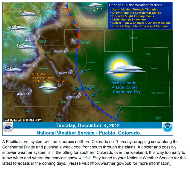
Click on the thumbnail graphic for the yesterday’s forecast map from the Nation Weather Service Pueblo office. Here’s the pitch:
A Pacific storm system will track across northern Colorado on Thursday, dropping some snow along the Continental Divide and pushing a weak cool front south through the plains…It’s way too early to know when and where the heaviest snow will fall
From The Denver Post (Joey Bunch):
After a forecast high near 70 degrees on Wednesday, moisture and then cold are expected to roll across the region on Thursday and linger through the weekend. The National Weather Service expects the high temperature on Saturday to reach 38 degrees, then only 28 on Sunday and Monday. Night-time lows 15 degrees, 11 and 13, respectively, would provide the city its coldest snap so far this season, forecasters warn.
The high Tuesday could remain below freezing. No snow totals have yet been predicted, but Denver has a 20 percent chance of precipitation on Thursday and Friday, and slight chances of rain or snow on Friday and Saturday…
Snow chances are better in Western Colorado at midweek, but diminishing toward the weekend. Steamboat Springs has a 70 percent chance of snow Wednesday night and Thursday. Aspen has a 70 percent chance of snow Wednesday night, and a 60 percent chance on Thursday. Telluride has a 30 percent chance of snow Wednesday night and a 40 percent chance on Thursday.
From the Cortez Journal editorial staff:
Coloradans expect some unseasonably warm days between Thanksgiving and Christmas, but they don’t expect daytime highs in the 50s for weeks on end. When they look up at the La Platas, they expect to see the snow line descending almost daily, not fluctuating up and down. When they check the weather forecast, they expect to see some major winter storms predicted as California rainstorms become Rocky Mountain blizzards, not “partly cloudy with 15 percent chance of snow flurries.” When they head for the slopes, they expect enough snow for a fast ride; they don’t want to scan the slopes ahead for bare patches.
Most years, those are reasonable expectations, but not this year. Last year’s winter was slow to start and quick to end.
Almost all the terrain west of the Mississippi, with the exception of the Pacific Northwest, is abnormally dry, with most of that map labeled “severe drought,” “extreme drought” or “exceptional drought.” Western Colorado ranges from severe to extreme. Reservoirs are low. The ground is parched. And so far, runoff predictions are not optimistic.
Weather fluctuates, of course. The West has always alternated dry spells with “wet” spells (which, generally, are actually only less dry than the long-term average), and warm winters with harsh ones. December 4 is early; a lot of snow could fall between now and late spring. Still, the same group of people most likely to call climate change a myth are the ones who insist that when they were children, winters were colder and snowier than those in recent years.
It’s past time to consider the question, “What if this is a glimpse of the future?” What if this is the direction we’re moving? What will we do for water?
Whether climate change has a human component — which is nearly beyond debate — and even whether the current drought is a part of it, adaptation is still essential. Don’t expect the interior West to get the attention, or the funding, commensurate with a flooded New York City coastline. New York isn’t going to send water to Kansas in exchange for wheat and corn. FEMA isn’t going to bring it in plastic bottles. California isn’t going to decide it needs less.
What runs down from the high peaks is all the water there is to be had, and it’s past time to realize that’s not always going to be enough.
From the Vail Daily (Scott N. Miller):
The National Weather Service’s office in Grand Junction predicts that a few minor storms may roll through northwest Colorado starting about the evening of Dec. 5. But the real chance of snow — and, crucially, cooler temperatures — won’t come until the week of Dec. 10.
Travis Booth, a forecaster in the National Weather Service’s Grand Junction office, said some “minor disturbances” will flow through the region later this week, but those storms will more closely resemble Monday morning’s showers, with a bit of snow in the upper valley and rain in Gypsum.
“Farther out there’s some promise,” Booth said. “The models have been inconsistent, but they do agree there should be a push of cold air.”
Meteorologist Joel Gratz of OpenSnow.com said the reasons for the change are complex — weather everywhere is interconnected, he said — but the most simple explanation is that the “jet stream,” a flow of air in the upper atmosphere, is shifting to the south. Generally, when the jet stream is tracking to the north, areas to the south stay fairly dry and brown — like the late fall we’ve had so far. When the jet stream drops to the south, so do the storms. This time of year, that means at least some snow.
Booth said one of the reasons the jet stream has stayed north is that it has been influenced by a persistent low pressure system in the Gulf of Alaska. That low is expected to change to high pressure, which will push the storm track to the south, and much closer to Colorado. When that happens, temperatures drop, so what snow does fall is more likely to stick, at least for a while.
From the Summit Daily News (Caddie Nath):
The two inches of snow that accumulated at Breckenridge Ski Resort Sunday night were the first the ski area has seen since its opening weekend Oct. 9, but forecasts suggests there may be more to come.
An admittedly weak winter system is set to move into Colorado Wednesday night and into Thursday — possibly favoring the northern half of the state with a few more inches of snow — may be the first storm of a changing weather pattern that could mean more snow and colder conditions for Colorado over the next few weeks…
In the short-term, however, there is more certain good news in the forecast for snowsports enthusiasts. The storm expected to move in Wednesday night into Thursday will hit areas north of Summit County hardest, but likely deliver only an inch or two locally. It should be followed over the weekend by another system that may produce more precipitation.


