Here’s the release from the Western Governors Association:
The drought that made 2012 one of the driest in the years in the past century will likely persist across much of the West into March of 2013, according to the new Quarterly Climate Impacts and Outlook from the Western Governors’ Association (WGA) and the National Oceanic and Atmospheric Administration (NOAA).
The Outlook combines maps, projections and other products that provide information to decision makers about current and likely future weather conditions. Among the features of this release is a chart depicting reservoir storage in each of the Western states, which is below average for all states but Washington and Montana.
The Western Governors are focused on preparedness and resilience in the event of continued drought in 2013. Given the extent and severity of the current drought, WGA co-sponsored the National Drought Forum on December 12-13, 2012 in Washington, DC.
“Drought impacts next year could be far more severe, especially given that the reservoir storage in many basins has been depleted,” said Kansas Governor Sam Brownback, who spoke at the event.
The Outlook is a quarterly publication that was developed by the WGA and NOAA after the two organizations signed a Memorandum of Understanding in June 2011. WGA and NOAA have also co-sponsored two regional meetings, one in the Pacific Northwest and one in the Upper Missouri basin.
All of the maps and information presented in the Outlook are also available from the National Integrated Drought Information System (NIDIS), which provides a number of online drought information tools at drought.gov. Western Governors were instrumental to the passage of NIDIS in 2006. NIDIS is currently up for reauthorization by Congress.
NOAA also releases region-specific Outlooks, including documents that focus on the Central Region, the Southern Great Plains, and the Western Region.
More coverage from Bob Berwyn writing for the Summit County Citizens Voice. Here’s an excerpt:
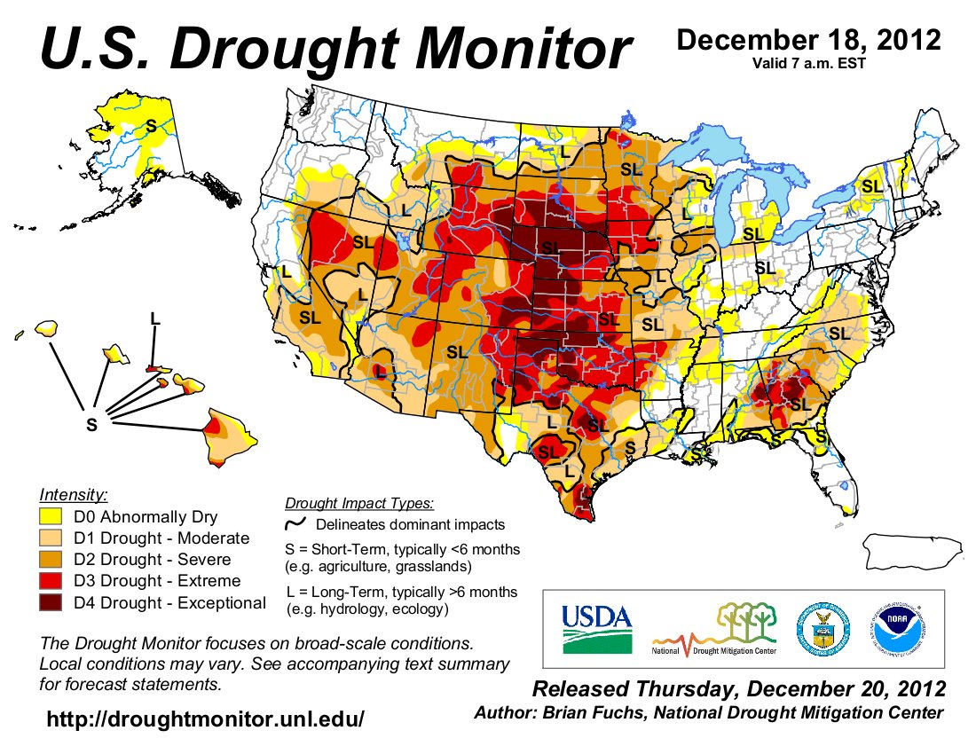
Without a surplus moisture this winter, drought conditions are likely to linger, and potentially even worsen, across parts of the West in 2013…
The cold season is typically the driest part of the year in most mid‐continental locations, so even with average seasonal precipitation, there will likely be little relief from the drought, according to the National Drought Monitor. The exceptions are Montana and California, where some relief is expected, based on early season precipitation.
New Mexico has been hardest hit, with reservoir storage at just 18 percent of capacity, but storage is below average in all western state except Montana and Washington.