‘Farming on the high, arid desert plains of Eastern Colorado forced people to be imaginative’ — Rick Kienitz

bessemerditch1890waterarchives.jpg

From The Pueblo Chieftain (Rick Kienitz):

Before beginning a job for a municipal water provider, I, like most people, thought no further about where my water came from than from the kitchen faucet.

I knew water came from streams and aquifers and that the beginning of the water cycle was rain and snow, but I would rarely think of how that water finally made it to my house. The idea that somehow water had to make the long trek from a snowy mountain top to my home did not concern or worry me.

Increasingly, water scarcity and a growing population’s demand causes people like me to think more about where that all-important resource comes from. Seeing the process and the complexity of providing water to a large city made me not only appreciate the value and importance of water in Southern Colorado, but also had me wonder where that water supply originally came from.

Farming on the high, arid desert plains of Eastern Colorado forced people to be imaginative. Men like T.C. Henry and David K. Wall built canals and laterals to carry water from the rivers further inland to irrigate crops. Although these canals were massive undertakings and could move large amounts of water, the farmlands were also enormous and water was not always available, especially during times of drought.

Farmers using these canals began to develop supplemental water supplies in order to grow crops during dry years. These great engineering feats used expansive tunnels and pipelines, as well as natural contours, draws and saddles in the Continental Divide to transport water and irrigate farmlands hundreds of miles away.
Since many of these supplemental systems became too expensive for farmers to maintain and operate, many are now part of municipal water systems and supplies.

Still, it took the vision, ingenuity, resourcefulness, skill, and hard work of these farmers to devise and build these systems. The Twin Lakes Reservoir and Canal Co. — which was originally developed to bring water through a series of tunnels to irrigate farms in Crowley County — now provides water to a number of cities including Colorado Springs, Pueblo, Pueblo West and Aurora.

The Busk Ivanhoe system used the old Carlton railway tunnel to bring water across the Continental Divide to farm land in Otero County under the Highline Canal. This system now provides water to Pueblo and Aurora.

These are just a couple of examples of the many amazing engineering and infrastructure projects developed by early farmers and entrepreneurs that continue to provide water for farming and also help supply water to thousands of people in cities and towns.

We, as citizens, owe much to the resourcefulness, hard work and forethought of those before us.

More Colorado Water 2012 coverage here.

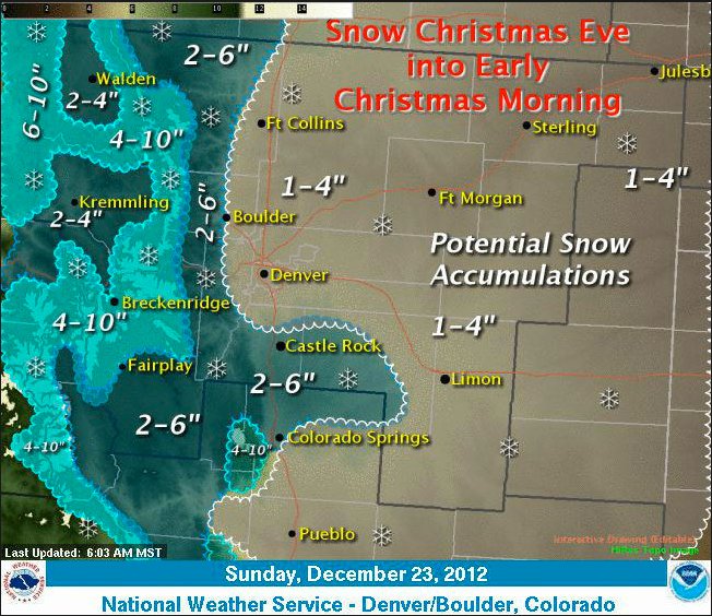
Forecast news: Snow is on the way — 2 to 6 inches for the Front Range mountains and South Park #COdrought #COwx

forecastnwsboulder12232012.jpg

From the National Weather Service Pueblo Office:

…WIDESPREAD SNOW CHRISTMAS EVE AND EARLY CHRISTMAS DAY…

A WHITE CHRISTMAS WITH IMPACTS TO HOLIDAY TRAVEL CONTINUES TO LOOK LIKELY ACROSS MANY AREAS OF SOUTH CENTRAL AND SOUTHEAST COLORADO AS THE NEXT WINTER STORM SYSTEM TAKES AIM ON COLORADO. THIS SYSTEM WILL DROP FROM THE PACIFIC NORTHWEST INTO NORTHERN NEW MEXICO BY MONDAY EVENING…SPREADING MODERATE TO POTENTIALLY HEAVY SNOW INTO THE CONTINENTAL DIVIDE DURING THE DAY MONDAY. SNOW WILL SPREAD INTO THE SOUTHEAST MOUNTAINS AND PLAINS LATE MONDAY AFTERNOON THROUGH MONDAY NIGHT.

ALTHOUGH FORECAST SNOWFALL ACCUMULATIONS ARE STILL SUBJECT TO CHANGE…THE SOUTHEAST MOUNTAINS AND PLAINS WILL LIKELY SEE WIDESPREAD LIGHT TO MODERATE SNOWFALL ACCUMULATIONS FROM LATE MONDAY AFTERNOON THROUGH TUESDAY MORNING. AT THIS TIME…THE SANGRE DE CRISTO AND WET MOUNTAIN RANGES AND TELLER COUNTY COULD SEE 5 TO 10 INCHES OF SNOW WITH SOME OF THE HIGHER ELEVATIONS POTENTIALLY SEEING AS MUCH AS A FOOT. ONE TO 4 INCHES OF SNOW COULD FALL ACROSS MOST THE SOUTHEAST PLAINS AND THE UPPER ARKANSAS RIVER VALLEY…WITH LOCALLY HIGHER AMOUNTS NOT OUT OF THE QUESTION ACROSS NORTHERN EL PASO COUNTY…AND THE NORTHERN SLOPES OF THE RATON MESA REGION…AS WELL AS THE SOUTHERN I-25 CORRIDOR REGION SOUTH AND WEST OF THE CITY OF PUEBLO. THE SAN LUIS VALLEY COULD ALSO PICK UP AN INCH OR TWO OF SNOWFALL FROM THIS STORM.

SNOWFALL PREDICTIONS ARE LIKELY TO CHANGE AS THE STORM APPROACHES AND THE FORECAST TRACK AND STRENGTH BECOMES MORE CERTAIN. AREAS WITH GREATEST UNCERTAINTY REMAIN ACROSS THE SOUTHEAST PLAINS WHERE A FEW FORECAST MODEL SIMULATIONS SUGGEST RAPID STRENGTHENING COULD OCCUR AS THE STORM MOVES INTO THE TEXAS PANHANDLE. IF YOU HAVE TRAVEL PLANS ACROSS SOUTH CENTRAL AND SOUTHEAST COLORADO CHRISTMAS EVE OR CHRISTMAS DAY…BE PREPARED FOR WINTER DRIVING CONDITIONS WITH THE LIKELIHOOD OF SLICK SNOW PACKED ROADS AND REDUCED VISIBILITIES. PLEASE CONTINUE TO MONITOR THE LATEST FORECASTS FOR THE MOST UP TO DATE INFORMATION CONCERNING THIS DEVELOPING WINTER STORM.

From The Denver Post (John Mossman):

Mike Baker, forecast meteorologist for the Weather Service, said Saturday night that snow could begin falling as early as Monday afternoon, with the bulk of the accumulation occurring Monday night, Christmas Eve. “It looks pretty good right now for a White Christmas,” said Baker. An inch or more of snow on the ground on Christmas morning is generally considered a White Christmas.

Because the storm will include upslope conditions Monday night, the north and east portions of the metro area might see only a trace of snow, with the south and west likely getting from 3 to 4 inches, Baker said.

“It will look pretty Christmas morning,” Baker said, “but the snow won’t be widespread and some places may not get much of anything.”