
From the National Weather Service Pueblo Office:
…WIDESPREAD SNOW CHRISTMAS EVE AND EARLY CHRISTMAS DAY…
A WHITE CHRISTMAS WITH IMPACTS TO HOLIDAY TRAVEL CONTINUES TO LOOK LIKELY ACROSS MANY AREAS OF SOUTH CENTRAL AND SOUTHEAST COLORADO AS THE NEXT WINTER STORM SYSTEM TAKES AIM ON COLORADO. THIS SYSTEM WILL DROP FROM THE PACIFIC NORTHWEST INTO NORTHERN NEW MEXICO BY MONDAY EVENING…SPREADING MODERATE TO POTENTIALLY HEAVY SNOW INTO THE CONTINENTAL DIVIDE DURING THE DAY MONDAY. SNOW WILL SPREAD INTO THE SOUTHEAST MOUNTAINS AND PLAINS LATE MONDAY AFTERNOON THROUGH MONDAY NIGHT.
ALTHOUGH FORECAST SNOWFALL ACCUMULATIONS ARE STILL SUBJECT TO CHANGE…THE SOUTHEAST MOUNTAINS AND PLAINS WILL LIKELY SEE WIDESPREAD LIGHT TO MODERATE SNOWFALL ACCUMULATIONS FROM LATE MONDAY AFTERNOON THROUGH TUESDAY MORNING. AT THIS TIME…THE SANGRE DE CRISTO AND WET MOUNTAIN RANGES AND TELLER COUNTY COULD SEE 5 TO 10 INCHES OF SNOW WITH SOME OF THE HIGHER ELEVATIONS POTENTIALLY SEEING AS MUCH AS A FOOT. ONE TO 4 INCHES OF SNOW COULD FALL ACROSS MOST THE SOUTHEAST PLAINS AND THE UPPER ARKANSAS RIVER VALLEY…WITH LOCALLY HIGHER AMOUNTS NOT OUT OF THE QUESTION ACROSS NORTHERN EL PASO COUNTY…AND THE NORTHERN SLOPES OF THE RATON MESA REGION…AS WELL AS THE SOUTHERN I-25 CORRIDOR REGION SOUTH AND WEST OF THE CITY OF PUEBLO. THE SAN LUIS VALLEY COULD ALSO PICK UP AN INCH OR TWO OF SNOWFALL FROM THIS STORM.
SNOWFALL PREDICTIONS ARE LIKELY TO CHANGE AS THE STORM APPROACHES AND THE FORECAST TRACK AND STRENGTH BECOMES MORE CERTAIN. AREAS WITH GREATEST UNCERTAINTY REMAIN ACROSS THE SOUTHEAST PLAINS WHERE A FEW FORECAST MODEL SIMULATIONS SUGGEST RAPID STRENGTHENING COULD OCCUR AS THE STORM MOVES INTO THE TEXAS PANHANDLE. IF YOU HAVE TRAVEL PLANS ACROSS SOUTH CENTRAL AND SOUTHEAST COLORADO CHRISTMAS EVE OR CHRISTMAS DAY…BE PREPARED FOR WINTER DRIVING CONDITIONS WITH THE LIKELIHOOD OF SLICK SNOW PACKED ROADS AND REDUCED VISIBILITIES. PLEASE CONTINUE TO MONITOR THE LATEST FORECASTS FOR THE MOST UP TO DATE INFORMATION CONCERNING THIS DEVELOPING WINTER STORM.
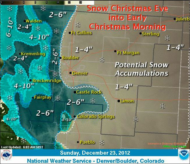
From The Denver Post (John Mossman):
Mike Baker, forecast meteorologist for the Weather Service, said Saturday night that snow could begin falling as early as Monday afternoon, with the bulk of the accumulation occurring Monday night, Christmas Eve. “It looks pretty good right now for a White Christmas,” said Baker. An inch or more of snow on the ground on Christmas morning is generally considered a White Christmas.
Because the storm will include upslope conditions Monday night, the north and east portions of the metro area might see only a trace of snow, with the south and west likely getting from 3 to 4 inches, Baker said.
“It will look pretty Christmas morning,” Baker said, “but the snow won’t be widespread and some places may not get much of anything.”