From The High Country News (Paige Blankenbuehler):
At the beginning of February last year, South Lake Tahoe in California was nearly 60 degrees Fahrenheit, almost 20 degrees above its historic average. At that time, the drought had been dragging along for four years and chair lifts at nearby ski resorts were swaying over barren slopes. Representatives from the California Department of Water Resources called the Sierra Nevada snowpack “dismally meager,” at only 23 percent of normal.
Now, it’s a drastically different story. January has been California’s best month for snowpack since 2011, and the state’s measurements are at 127 percent of normal. Although California’s snowpack is above normal this year, it’s still not enough to make up the deficit from the persisting drought in the state. It is enough, though, to keep ski resorts running and reservoirs in the state from drying up.
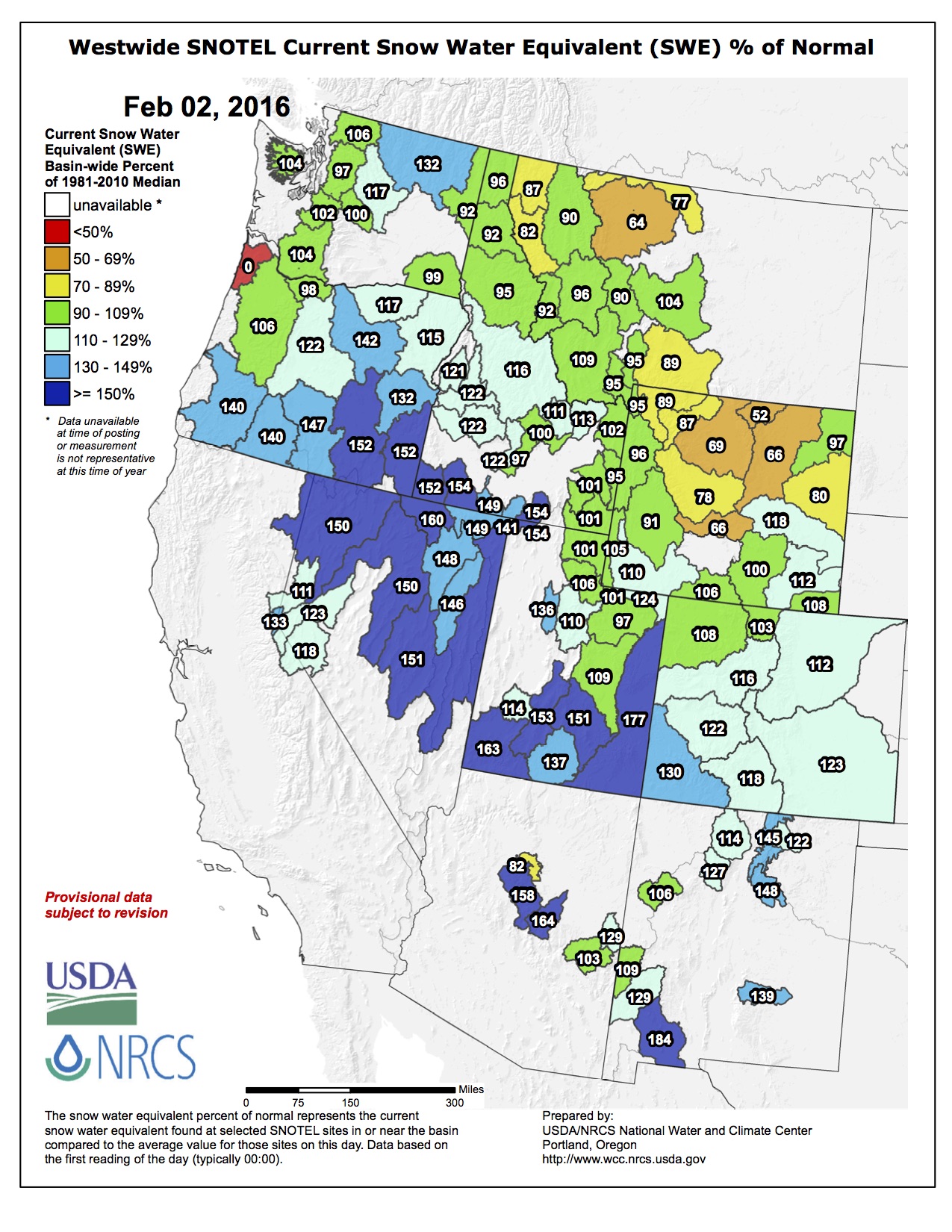
Above normal snowpack measurements are tracking for most of the West, too. The season was off to a slow start with sporadic storms October through December, but January winter precipitation increased measurements across all states, according to the Natural Resources Conservation Service’s SNOTEL sites, which measure snow depth at thousands of stations nation-wide. Utah claimed the biggest increase from early season snowpack, from 84 percent to 118 percent snowpack readings on February 1. Over the past month, California snowpack increased from 90 to 127 percent, and Arizona jumped from 83 percent to 113 percent of normal.
Only two Western states, Montana and Wyoming, are below the historic benchmark for “normal” at this time of year — and not by much. North-central Wyoming and the eastern slope of the Northern Rockies in Montana are the low-snow areas. Both states are more than 80 percent of normal for this time of year, and February is a crucial month for snow. Snowpack typically builds until April, says Alan Haynes, a hydrologist for the California Nevada River Forecast Center.
But even states with snowpack measurements lagging behind, readings from early in the season have improved. Since December, snow depth in Montana has hobbled to 84 percent of normal — from 73 percent in early December. And Wyoming similarly increased to 84 percent, from about 75.
Measurements from SNOTEL sites across the West, which have been recording precipitation and snow depth this season since Oct. 1, 2015, are painting a reverse picture of last year. Areas that were far below average last year — the Tahoe Basin in California and the Cascades in the Pacific Northwest — are recording the highest precipitation in the West so far this season.
The most precipitation has fallen in Washington and Oregon. In terms of percent of normal snowpack, Nevada has been leading the region with nearly 140 percent of normal readings across the state, according to data compiled by NRCS.
In California, local forecasters say the past few months are finally chipping away at the state’s five-year drought. The deficit will be hard to overcome, Haynes says, but if this season continues, the state might avoid fallowing fields. California gets 30 percent of its total water supply from snowpack, and reservoirs that have been low are now slowly filling up. Shasta Reservoir, one of the largest storage systems in the state is currently more than 50 percent full, or about 75 percent of the historical average for this time. “If we get shut out for the rest of the winter, the outlook could be bleak,” Haynes says.
Winter recreation in California is also benefitting from the abundant snow. The Hagens Meadow SNOTEL site near South Lake Tahoe is reporting 53 inches of snow depth, or 158 percent of normal, and Ostrander Lake site, in south Yosemite National Park, has had 220 inches of snow…
While El Niño may be creating a more robust winter storm pattern, it’s difficult to attribute all of the heavy snow to the global weather phenomenon. “This year has been a really strong El Niño, but we’re seeing snowfall patterns that are somewhat unusual for this weather event,” Haynes says. The Northwest, which would typically be fairly dry, is wet. And precipitation in south-central California hasn’t lived up to early El Niño predictions for that part of the state. The U.S. Drought Monitor remains cautiously optimistic about recovery. According to the center’s January 28 report, “the trend is going in the right direction for now with a good chunk of the snow season still left to play out over the next two months.”
From The Kearney Hub (Lori Potter):
“Everything is just in good shape,” Civil engineer Cory Steinke said in his report Monday to the Central Nebraska Public Power and Irrigation District Board of Directors.
Lake McConaughy, which stores water for CNPPID irrigation, hydropower, wildlife habitat and recreation, and for other water interests, is 83.5 percent of a full volume at 1,457,000 acre-feet.
Steinke said North Platte River inflows at Lewellen have been around 1,200 cubic feet per second, and the South Platte is “roaring pretty good” at 1,200-1,400 cfs at the Colorado-Nebraska state line. Releases from Lake McConaughy were at 900 cfs Monday.He said South Platte water is running through CNPPID hydros and is the main factor in overall flows exceeding current Central Platte River targets set by the U.S. Fish and Wildlife Service for wildlife habitat. Steinke expects diversions into the Phelps Canal for seepage into groundwater that eventually reaches the river can continue until at least Feb. 15.
Meanwhile, mountain snowpacks that produce the Platte River’s headwaters continue to grow. Steinke said that in the North Platte Basin, the upper area’s snowpack is at 98 percent of normal for Feb. 1, and the lower basin is at 106 percent. The South Platte Basin is at 105 percent.