Rifle “State of the River” meeting recap

Rifle Falls back in the day via USGenWeb

From the Glenwood Springs Post Independent (Ryan Hoffman):

Conditions in the Upper Colorado River Basin, particularly in Colorado, are OK for the time being, officials said Wednesday during a “state of the river” address in Rifle.

However, the largest of several caveats to that statement falls in the context of the entire Colorado River Basin, specifically the lower basin, where water use continues to outpace supply.

Additionally, good flows and filling reservoirs in the Centennial state and in other areas of the upper basin — a region that includes western Colorado, eastern Utah, a sliver of Arizona and portions of Wyoming and New Mexico — are a sign that drier conditions loom in the future.

The combination of the two could lead to reductions in water usage, Eric Kuhn, general manager of the Colorado River Water Conservation District, said Wednesday.

The statement was not a prediction, Kuhn added, but a call for preparedness.

The cautionary note comes at a peculiar time basinwide.

“So right now … you’re … reading a lot of things about what’s going on in Arizona and the drought in California, the lower basin states are using too much water and they’re having to cut back — all of that is true,” Kuhn said. “But we’re kind of in an interesting situation. In Colorado conditions are OK to wet.”

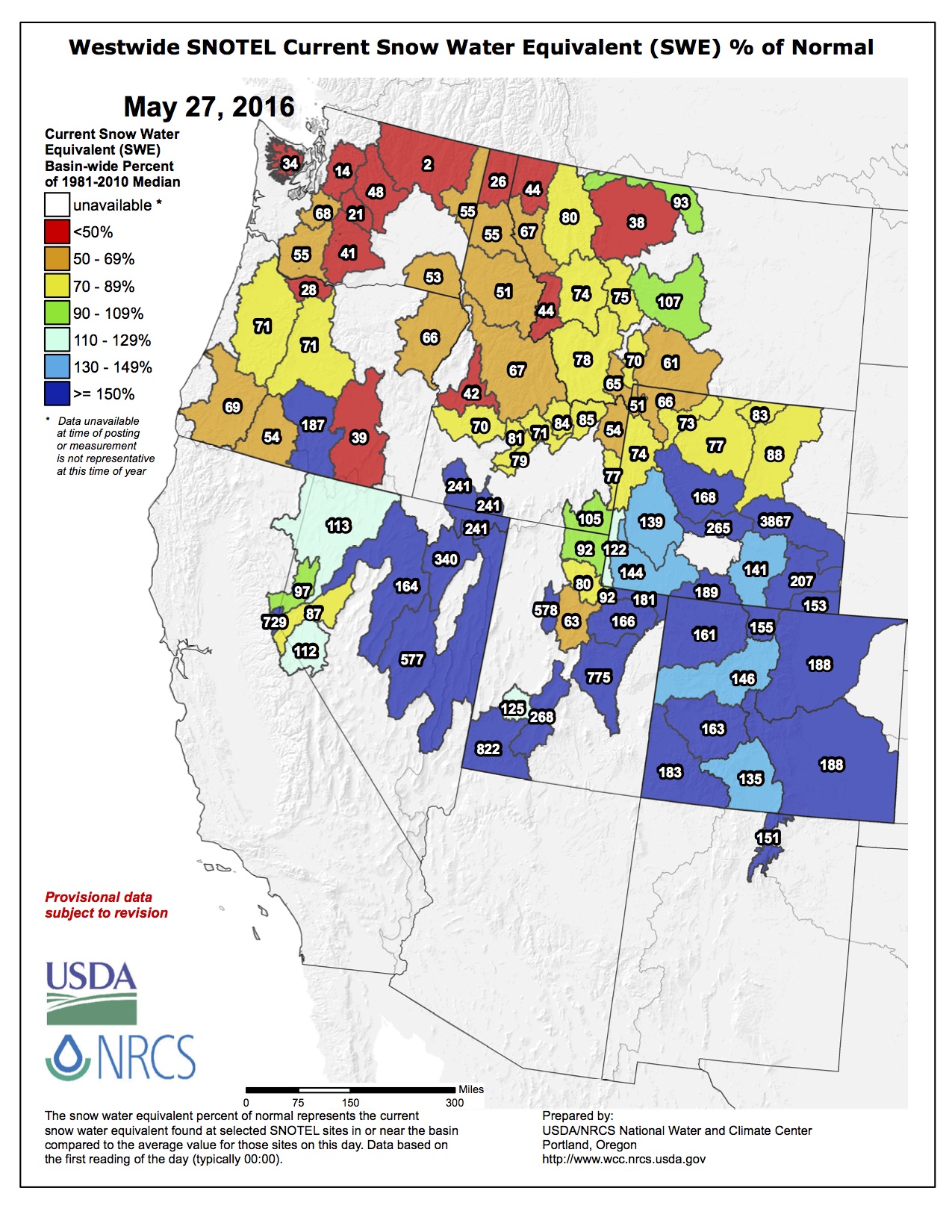
Snowpack for the Upper Colorado River Basin was at 118 percent of average as of May 24, according to provisional SNOTEL data from the Natural Resources Conservation Service.

While the basinwide snowpack is less than the past two years, it is not “too far off normal,” said Nolan Doesken, Colorado state climatologist.

A streamflow forecast from NRCS predicts most of the Upper Colorado River Basin will hover around 100 percent of average May through July. And, Colorado’s reservoir storage statewide at the end of April was 112 percent of average.

Operations at two smaller storage reservoirs for the Upper Colorado River Basin, Green Mountain Reservoir in Summit County and Ruedi Reservoir east of Basalt, reflect average conditions, according to Victor Lee, hydrologic engineer for the Bureau of Reclamation’s eastern Colorado area office.

Green Mountain is expected to fill around July 10, and Ruedi is expected to fill around July 15.

While Colorado is looking “pretty darn good,” as Kuhn said, trouble lies downstream, where the combined storage in two of the nation’s largest reservoirs is declining.

Specifically, Lake Mead continues to see a drop in its water level to the point of a historic low. Water from Lake Powell has been released to stem Mead’s decline. A forecast from the Bureau of Reclamation predicts 9 million acre-feet of water could be released from Lake Powell in 2016 to help Lake Mead.

The problem, Kuhn said, is the demand in the lower basin is outpacing supply.

Numbers, shared Wednesday night, for Lake Mead’s water budget show an inflow of 9 million acre-feet, while outflow is 9.6 million AF. Evaporation claims another 0.6 million AF, which leads to a total deficit of 1.2 million AF.

While there has been a great deal of attention paid to the word “drought,” Kuhn said conditions on the Colorado River have mostly been stable since 2005.

“I would argue we’re not in a drought in the Colorado River Basin as a precipitation drought,” he said. “We may be in a drought because the demand exceeds supply in the system, especially in the lower basin.”

Should conditions worsen, it would exacerbate the situation.

As for when exactly conditions will worsen is uncertain, but Doesken said it could be right around the corner.

“This year we’re just cooking along as pleasant as can be, but what do you know about drought,” he asked. “It is always around the corner, so the longer we have little drought on the map the sooner we’ll be back into the next drought. … I guess I’d say that is a prediction.”

Organizers expect record attendance at Poudre RiverFest — The Fort Collins Coloradoan

From the Fort Collins Coloradan (Jacy Marmaduke):

The third annual Poudre RiverFest will combine music, food, beer and environmentally focused activities at Fort Collins’ Legacy Park on Saturday, June 4.

The free event will take place from 9 a.m. to 6 p.m. Festival organizers are still seeking volunteers.

The festival, a revamped version of the annual Poudre cleanup that took place in the ’90s and ’00s, will include activities that highlight the river’s role as a habitat for wildlife, a recreation area and a source of clean drinking water. Educational and volunteer activities are planned throughout the day, and a celebration with live music, food and a beer garden will begin at 11 a.m. Performers will include Justin Roth, Grant Farm, and Mama Lenny and the Remedy.

Organizers anticipate an attendance of about 5,000 people, up from about 2,000 last year.

Eight area organizations are putting on the festival: Save the Poudre, Sustainable Living Association, Bird Conservancy of the Rockies, Synergy Ecological Restoration, National Association for Interpretation, Coalition for the Poudre River Watershed, CSU Environmental Learning Center and Wildlands Restoration Volunteers.

Anyone interested in volunteering at the festival should visit poudreriverfest.org/volunteer. Volunteers receive a T-shirt, one free beer at the event and a $5 Avogadro’s Number gift card. Volunteer orientation will take place at New Belgium on June 1 at 5:30 p.m.

Here’s the Poudre River Fest website with all the inside skinny.

#Snowpack #Runoff news:

Westwide SNOTEL map May 27,  2016 via the NRCS.
Westwide SNOTEL map May 27, 2016 via the NRCS.

From the Fort Collins Coloradoan (Alicia Stice):

Running just above 6 feet, the river is still comfortably below its 10-foot flood level in Fort Collins, though flows remain well above average for this time of year. Thursday, the Poudre River gauge in Fort Collins recorded 1,930 cubic feet per second, almost three times the average for the site. Late-season snowfall has meant a higher-than-usual snowpack this year, which can cause the river to rise quickly. The South Platte River Basin is at 139 percent of the average snowpack for this date, Huse said.

West Salt Creek Slide: Snowmelt-filled pond on landslide might spill — The Grand Junction Daily Sentinel

Grand Mesa mudslide before and after via The Denver Post

From The Grand Junction Daily Sentinel (Gary Harmon):

Authorities are monitoring the pond atop the land that tipped in toward Grand Mesa in a major landslide two years ago, watching for signs that it could spill over as the high country snowmelt increases.

Mesa County and other officials went to a level of heightened awareness a week ago, as what is known as the “sag pond” filled with snowmelt, said Pete Baier, the county’s deputy administrator for operations.

“We’re entering into uncharted territory here for the next few days,” Baier said on Thursday.

The pond is filling to the point that it is as high as it was last year, when there was concern it might spill, “and there’s still snow up there to melt,” Baier said.

The nearly 3-mile-long landslide of 39 million cubic feet of rock and debris slid down the West Salt Creek drainage on May 25, 2014, engulfing three men — father and son Clancy and Dan Nichols and Wes Hawkins — who were working to clear an irrigation ditch in the drainage.

The water in the sag pond passed the 20-foot depth mark and the question isn’t so much whether it grows higher, but whether it suddenly falls, Baier said.

With that possibility in mind, the county alerted Collbran and Plateau Valley officials, as well as state and federal authorities, about the status of the pond.

The next step — alerting residents that they should be prepared to move — will depend on a variety of factors, such as a shift in the block still clinging to the side of the mesa, a new source of water running into the pond, or a large thunderstorm headed toward the slide, Baier said.

A shift or break could result in an evacuation of downstream residences.

The pond holds about 400 acre-feet of water and no one knows how long it can be contained, or what might happen should it suddenly release, carrying with it tons of mud, rock and debris.

Heavy rains two years ago soaked the soils as the snowmelt geared up, setting the stage for the slide.

There’s no prediction of rain, but there is more snow atop the mesa than there was two years ago, Baier said.

From The Denver Post (Jesse Paul):

Mesa County authorities have raised the alert level at the site of the massive West Salt Creek landslide near Collbran because of increased spring runoff.

The county said Friday it has initiated a Level Two response to its emergency preparedness action plan, advising residents in the area to be prepared to evacuate.

A pond at the landslide area released water and cut a new drainage channel Thursday evening.

“Mesa County Sheriff deputies are contacting people who live nearby in addition to reverse 911 notifications,” the county said in a news release. “Road and Bridge equipment is being staged in Collbran as well as thousands of sand bags in the event flooding becomes an issue.”

The 2.8-mile-long West Salt Creek landslide on the Grand Mesa on May 25, 2014, was the longest such slide in Colorado history. It killed three men.

Worries of another catastrophe have persisted in the slide’s wake, particularly last spring, when heavy rains prompted warnings. The main risk, officials say, is in early spring as snowmelt travels down the slide area.

Water that has collected in a depression near the top of the slide has created a “sag pond,” which continues to spark fears among geologists of another catastrophe.

In October 2015, the Colorado Geological Survey said conditions remain at the West Salt Creek area that could prompt another disaster of comparable magnitude.

The highest alert level for the landslide area is Level Three.

“The alert level was raised because the pond spilled over the slump block at the head of West Salt Creek early (last Friday) morning,” said Jeffrey Coe, a research geologist with the U.S. Geological Survey who has studied the slide. “There was some local flooding near the toe of the landslide. A flood watch was issued for areas downstream. But from everything that I have heard so far, the impact to downstream areas has been minimal.”

Coe’s research showed the initial deadly slide was caused by a rainstorm over melting snowpack in the area, triggering a series of events that led to the disaster.

The county said Friday that an initial water surge made it through Collbran without overflowing the banks of Plateau Creek. There have been no signs of land movement.

“Right now the landslide is doing what we want and expect it to do,” the county said. “However, if Mother Nature decides to take more land down, we want residents to be ready to evacuate.”

Officials say they have a team flying over the area that will monitor the conditions.

After years of #drought and overuse, the San Luis Valley aquifer refills — The High Country News

Artesian well Dutton Ranch, Alamosa 1909 via the Crestone Eagle

From The High Country News (Paige Blankenbuehler):

The San Luis Valley in southern Colorado is an 8,000-square-mile expanse of farmland speckled with potato, alfalfa, barley and quinoa fields between the San Juan and Sangre de Cristo mountain ranges. Only about 7 inches of rain fall each year in the San Luis Valley. But while farmers and ranchers can’t depend on moisture above ground, they make up the difference beneath it. The valley is underlain by a vast aquifer, which is punctured by more than 6,000 wells that pump water onto the valley’s crops and supports the livelihoods of 46,000 residents.

For generations, the aquifer provided enough water to sustain the arid farming community. But beginning in 2002, a multi-year drought shrunk the nearby streams and water table. Farmers and ranchers began to notice the falling levels of the Rio Grande and the rapidly draining aquifer. Some wells throughout the valley abruptly stopped working.

The aquifer dwindled so much that the Closed Basin Project, a Bureau of Reclamation pumping effort that had long met downstream water diversions and delivered flows to the Rio Grande River to maintain the Alamosa National Wildlife Refuge, failed to convey enough water to the valley’s farms and ranches. “We operate in a highly over-appropriated system,” says Cleave Simpson, manager of the Rio Grande Water Conservation District, the main water management entity in the San Luis Valley. “Agriculture had overgrown and far outstretched water supply.”

Without change, state water regulators could shut off thousands of wells. So the valley’s farmers and ranchers, unlike other agriculture communities in the West, did something nearly unprecedented: They decided not to ignore the problem.

In 2006, the Rio Grande Water Conservation District and San Luis Valley water users created the sub-district project, an innovative solution for solving water problems. The plan would charge farmers and ranchers $75 per acre-foot for the groundwater they pumped, and in turn use the funds to pay farmers to fallow portions of their fields, limiting demand on the water supply, as High County News reported in 2013. The experiment began at sub-district 1, the valley’s largest of six sub-districts, which sits at the heart of the San Luis Valley in aptly named Centre, just west of the Great Sand Dunes National Park.

Center-Pivot and Acequia Farms. The green belts along the Río Culebra and tributaries in San Acacio, San Luis, Chama, Los Fuertes and other unmarked villages are the principal acequia farm bottomlands in Costilla County. The  center-pivot circles are concentrated in the Blanca-Ft. Garland vicinity to the N and the Mesita-Jaroso vicinity due W and SW of the acequia bottomlands.  Source: Google Maps (screenshot).
Center-Pivot and Acequia Farms. The green belts along the Río Culebra and tributaries in San Acacio, San Luis, Chama, Los Fuertes and other unmarked villages are the principal acequia farm bottomlands in Costilla County. The center-pivot circles are concentrated in the Blanca-Ft. Garland vicinity to the N and the Mesita-Jaroso vicinity due W and SW of the acequia bottomlands. Source: Google Maps (screenshot).

Today, four years into the operation of the project after it launched in 2012, the aquifer is rebounding. Water users in sub-district 1 have pumped one-third less water, down to about 200,000 acre feet last year compared to more than 320,000 before the project. Area farmers have fallowed 10,000 acres that once hosted thirsty alfalfa or potato crops. Since a low point in 2013, the aquifer has recovered nearly 250,000 acre-feet of water. By 2021, the sub-district project plans to fallow a total of 40,000 acres, unless the ultimate goal of rebounding the aquifer can be reached through other conservation efforts, like improving soil quality and rotating to more efficient crops.

The plan’s proponents say it provides a template for groundwater management in other arid communities whose agricultural economies are imperiled by drought. “The residents of the valley know that they are in this together, and that the valley has overgrown the water available to us,” says Craig Cotten, Almosa-based division engineer for the Colorado Division of Water Resources. “This is a water user-led solution, which makes it unique. I really think this can be a model.”

Crucially, the plan is state-mandated, which requires everyone to either participate in a district, fallow their fields or work with water engineers to develop their own augmentation plans, which in turn need to be approved by state water courts. Those choices — paying premiums for groundwater or scaling down operations significantly — have been tough for farmers. Nevertheless, Simpson says the valley’s water users have gotten on board. “It’s not comfortable but most everyone has really come forward,” Simpson says. “It’s a bit of a paradigm shift for farmers who are individualistic and don’t typically work together — but by necessity they realize that we will bankrupt ourselves if we continue to stretch our water resource.”

But water users in the San Luis Valley have also gone beyond the call of duty, says Heather Dutton, manager of the San Luis Valley Water Conservancy District. While the SLVWCD helps include users in its augmentation plan as an alternative to joining the sub-district project, Dutton says that few water users have gone that route. That’s partly because farmers and ranchers themselves have helped create the sub-district rules, through participating in public meetings and getting involved with the board of managers. “This has been a good exercise in self-governance,” Dutton says. “It’s been a success story in people coming together and trying things that my grandpa’s era would have thought were crazy.”

Although sub-district 1 has proved a success, the broader sub-district project remains in its fledging stages. In March, Colorado District Court in Rio Grande County mandated that sub-district 2, a cluster of a hundred or so wells between Monte Vista and Del Norte, unroll as phase two of the program. The second district is currently forming a board of managers to develop official rules for farmers and ranchers within the territory. The Rio Grande Water Conservation District is still working with valley residents to implement the remaining four sub-districts.

Still, the project’s first phase has been encouraging for residents. Patrick O’Neill grew up in Central California’s San Joaquin Valley and first came to the San Luis Valley in 1998 to work as an intern at Agro Engineering, a consulting company. Though he later returned to his family farm in California, he came to feel that the Central Valley, built on its own wasteful groundwater use, was not sustainable. He returned to the San Luis Valley in 2005, where he now owns Soil Health Services in Alamosa and works with area farmers and ranchers to improve soil health. “I chose this place in a very deliberate way for my home because there’s potential for putting our water system back into balance,” O’Neill says. “People here are much more conscious of how much water they are using.”

Salida: Interbasin Compact Committee talks taxes — The Mountain Mail

ARBWF-SalidaSteamplantArkRiver

From The Mountain Mail (Brian McCabe):

The Interbasin Compact Committee continued its ongoing discussion about Colorado water rights and river basins at a meeting Tuesday in Salida.

The IBCC was founded through the Colorado Water for the 21st Century Act to lead conversations and address issues about Colorado’s water.

The Upper Arkansas Water Conservancy District hosted the event and kicked off the meeting with a presentation by the Arkansas River Basin PEPO (Public Education, Participation and Outreach) Workgroup, led by Chelsey Nutter and Jean Van Pelt.

They explained four tasks they are working on, including participation and partnership building, focusing specifically on the Arkansas Basin area for education.

Their second task is to develop a Water 101 presentation for education, and they are currently working on a documentary about water and the Arkansas Basin.

Their third task is to help facilitate communication among the Arkansas Basin Roundtable, the Colorado Water Conservancy Board, the IBCC and the public, by integrating the information gathered into public outreach forums.

Finally, they are working to market the Arkansas Basin by designing a mission, logo and online resources, including a website and a Facebook presence.

Bob Randell, an attorney with the IBCC, discussed the Colorado Supreme Court decision earlier this month, in which BP America Production Co. will be refunded millions in oil and gas severance taxes.

Randell explained that the refunded taxes will have a direct effect on Colorado general funds and Department of Local Affairs grants, which will not be adding any additional money to 2016 and 2017 Tier 2 programs.

Sean Cronin, the South Platte River Basin representative, spoke about how that will affect the Water Supply Reserve Account.

“With demand outpacing supply, we will have to maximize our limited dollars,” Cronin said. “We want to provide folks with confidence that we are using WSRA funds as effectively as possible.”

Cronin said some of the options they have been looking at to help the program include:

• Looking at other grant deed programs for ideas.
• Considering how money is spent to hire contractors.
• Looking at financial need analysis for applicants, with a sliding scale depending on financial stability.
• Encouraging match requirements.
• Considering holding back a percentage of funds until progress reports on projects have been turned in and reviewed.

During the Lean Process update, Eric Kuhn, an appointee to the IBCC by the governor, raised a point about the difficulty with working with different parties on a project.

“Sometimes we miss the biggest concern,” Kuhn said, “trying to do something with a complex project. When you have two major entities with a lack of consensus, you hope it works out, because the permitting process only works as long as people agree on it.”

Becky Mitchell with the IBCC responded, saying, “What we came up with out of the Lean Process is that the state won’t jump into those kinds of situations.”

Cronin also said he had heard it wasn’t so much a problem in other parts of the country, only Colorado.

“I did hear that Colorado has had special circumstances, but that it is common among Western states, but we’re not the worst,” Mitchell said.

The committee also debated an idea of placing a tax on drinking liquid containers, from children’s juice boxes to cans of soda, as a possible source for the additional funding.

No decisions on the tax were made, but it was jokingly said that Colorado would need a drought for a tax like that to go through.

Did You Miss NPR Presents’ Going There: The Future of Water? — KUNC

NPR panel discussion of The Future of Water at CSU May 24, 2016. L to R: Patty Limerick, Roger Frugua, Melissa Mays, Paolo Bacigalupi, Kathleen Curry, and host Michel Martin.

From KUNC (Robert Leja):

KUNC welcomed All Things Considered Weekend Host Michel Martin to Colorado State University for a live storytelling event about the evolving legal, ethical, and social conversations around water.

Watch it.

Panelists include:

Paolo Bacigalupi is a Hugo award-winning author of The Water Knife. Bacigalupi’s writing has appeared in Wired magazine, High Country News, OnEarth magazine,The Magazine of Fantasy and Science Fiction, Asimov’s Science Fiction magazine and on Salon.com.

Kathleen Curry is a Colorado native and rancher who served in the Colorado Legislature from 2005 to 2010. Prior to serving in the Legislature, she managed the Upper Gunnison River Water Conservancy District.

Roger Fragua of Jemez Pueblo in New Mexico has dedicated his professional career to the advancement and development of American Indian communities. Roger is currently the president of Cota Holdings LLC and ndnEnergy LLC. Both organizations are engaged in tribal development in the energy sector.

Patty Limerick is the faculty director and chair of the board of the Center of the American West at the University of Colorado, Boulder, where she is also a professor of environmental studies and history. In addition, Limerick serves as the official state historian for Colorado State and was appointed to the National Endowment for the Humanities’ advisory board and the National Council on the Humanities in 2015.

Melissa Mays has proudly lived in Flint, Mich., since 2002, where she is a clean-water activist. With her husband, Melissa formed Water You Fighting For, an organization that connects activists with the stated mission of standing together against the loss of democracy and denial of clean, safe and affordable water.