The east end of the Twin Lakes Tunnel on June 6, 2016. A graph showing the level of water flowing through the Twin Lakes Tunnel this week. The tunnel began diverting water, after being closed for two weeks, on Tuesday, June 28, 2016.
ASPEN – The unnatural order of things was restored Tuesday as the Twin Lakes Tunnel began diverting water to the east again from the headwaters of the Roaring Fork River, after having been closed for two weeks.
The tunnel was closed temporarily after constraints in water rights required that it stop diverting from the Fork, Lost Man and Lincoln creeks, and other tributaries in the headwaters.
The tunnel under the Continental Divide had been diverting about 620 cubic feet per second (cfs) before diversions were stepped down over a three-day period from June 14 to 16, when the tunnel closed.
The reintroduced native flows down the Fork and Lincoln Creek added noticeable intensity to the river as it made its way through the Grottos, Stillwater and Slaughterhouse reaches near Aspen.
One of the constraints on the legal rights of the tunnel is that when the Colorado Canal in Ordway can divert freely because there is plenty of water in the lower Arkansas River, it cannot demand water from the Roaring Fork.
But the spring runoff has slowed, pinching the supply of water available to the canal from the Arkansas. As such, it can now legally call for water from the Roaring Fork.
“The Colorado Canal is being called out, so we can start diverting the tunnel under the direct flow portion of the right,” wrote Kevin Lusk, the president of the board of the Twin Lakes Reservoir and Canal Co. and a principal engineer at Colorado Springs Utilities, in an email Tuesday.
The other constraint was that the Twin Lakes Reservoir and Canal Co. had filled its storage allotment of 54,452 acre-feet of water in Twin Lakes Reservoir.
With that “bucket” filled, and the Colorado Canal still in priority, the tunnel had to be closed.
Not all of the water diverted from the Fork’s headwaters goes to the Colorado Canal, however, as the Independence Pass Transmountain Diversion System, of which the Twin Lakes Tunnel is the key component, now also helps meet water needs in several Front Range cities.
The diversion system is technically owned by the Twin Lakes Reservoir and Canal Co., which is based in Ordway. But Aurora, Colorado Springs, Pueblo West, and Pueblo own almost all of the shares in the company.
On Tuesday, the Twin Lakes Tunnel, which begins at Grizzly Reservoir on Lincoln Creek, was opened back up and about 200 cubic feet per second began flowing east, primarily from Lincoln Creek and the creeks in Brooklyn, New York, and Tabor gulches.
In response, levels in the Roaring Fork River near Aspen fell sharply.
The river at Difficult Campground, for example, was flowing at 390 cfs at 6 a.m., Tuesday morning, but had fallen to 244 cfs by 8 p.m.
And the measuring gauge on Stillwater Drive, just below the North Star Nature Preserve, showed the river flowing there at 510 cfs at 6 a.m. and at 311 cfs by 8 p.m.
On Wednesday, Lusk said that new calls for water from various shareholders in the Twin Lakes Reservoir and Canal Co. mean that water from Lost Man Creek and the main stem of the Fork would soon be added to the flow of water being sent east through the tunnel.
Lusk said he expected the tunnel to continue diverting water through the summer.
This marked the second year in a row the Twin Lakes Tunnel was forced to cease diverting due to wet conditions on the east side of the pass.
During most of the time the Twin Lakes Tunnel was closed, diversions continued to flow as usual through the Bousted Tunnel, which sends water east from the headwaters of the Fryingpan River, as well as from Hunter, Midway, and No Name creeks near Aspen.
Around 800 cfs has been flowing through the Bousted Tunnel for most of June.
And according to the Pueblo Chieftain, the total diversion from the Fry-Ark project so far this year is about 51,000 acre-feet of water.
Add that to the approximately 25,000 acre-feet diverted so far by Twin Lakes, and it means about 76,000 acre-feet has been diverted from the Roaring Fork River watershed so far this year, not counting what may have been sent through the Busk-Ivanhoe Tunnel, which also diverts from the upper Fryingpan.
Ruedi Reservoir, by comparison, can hold 102,373 acre-feet.
Editor’s note: Aspen Journalism, the Aspen Daily News, and Coyote Gulch are collaborating on coverage of rivers and waters. The Daily News published a version of this story on Thursday, July 30, 2016.
Click here to go to the US Drought Monitor websites. Here’s an excerpt:
Summary
Please note the Drought Monitor depicts conditions valid through Tuesday morning, 8 a.m., EDT (12 UTC); any of the recent locally heavy rain which fell after Tuesday morning (June 28) will be incorporated into next week’s drought assessment. For the 7-day period ending June 28, despite pockets of locally heavy rain (which led to catastrophic flooding in parts of West Virginia), above-normal temperatures and below-normal rainfall caused dryness and drought to expand or intensify across portions of the central and eastern U.S. Nationally, the percent of soil moisture rated poor to very poor climbed 5 points over last week to 31 percent (as of June 26, according to USDA-NASS), which was 14 percentage points higher than last year at the same time…
Northern Plains
Heat and dryness caused drought conditions to intensify locally. While showers were noted over northern-most portions of the region for a second consecutive week, drought intensified and expanded farther south. Areas hardest hit by the heat and dryness extend from northeastern Wyoming into western South Dakota. Severe Drought (D2) was expanded to encapsulate areas that have received less than 60 percent of normal (locally less than 50 percent) rainfall over the past 90 days. Furthermore, satellite-derived vegetation health imagery as well as rainfall data indicated conditions have rapidly worsened to Extreme Drought (D3) in a small area immediately adjacent to the Black Hills. Farther east, Abnormal Dryness (D0) also expanded across southern portions of South Dakota where 60-day rainfall was near or below 60 percent of normal. Likewise, D0 was expanded over northern Wyoming where similar short-term deficits were noted…
Central and Southern Plains
While much of the region remained mostly drought free, excessive heat (100°F or greater) coupled with pronounced short-term dryness necessitated the introduction of Moderate Drought (D1) in central Oklahoma. Over the past 60 days, this new D1 area has reported 30 to 55 percent of normal rainfall (locally less); rapid drought intensification in this area is likely if rain does not materialize soon…
Texas
Texas remained free of drought following a much-wetter-than-normal May. However, recent 100-degree heat and short-term dryness have raised concerns over the potential for a return to “flash” drought (rapidly occurring drought caused by a combination of dryness, high heat, and strong winds)…
Western U.S.
Due to the onset of the West’s “dry season”, changes to the region’s drought depiction during the summer months are usually minor, if any. However, Abnormal Dryness (D0) was expanded across northern Idaho to reflect declining soil moisture supplies brought on by a lack of rainfall over the past 60 days. Protracted short-term dryness — despite generally cooler-than-normal weather — has also been noted along the northern Pacific Coast. These more northerly coastal ranges typically receive some precipitation during the latter half of spring and early summer, and 60-day rainfall has tallied 30 to 50 percent of normal (deficits of 2 to 6 inches) from northwestern California to the Puget Sound…
The north part of the valley floor area includes a wetlands area. The interpretive sign at the trail head mentions that the Basketmakers grew corn and squash in addition to hunting deer, rabbits, turkeys, and porcupine, and gathering. Photo via 4CornersHikes.blogspot.com.
The U.S. Forest Service has put the final touches on a project that effectively restores an almost 20-acre wetland in Falls Creek, adding a rich biodiverse area to the lush green valley northwest of Durango.
In the 1990s, it was discovered that the land in Falls Creek, at the north end of County Road 205, was for sale. Rumors circulated that the owner at the time, Utah Power and Light, a subsidiary of PacifiCorp Utility Co., was in talks with developers that were interested in constructing several hundred homes in the tucked-away valley.
Fearing the archaeologically rich area would be developed, a grass-roots movement lobbied for almost two years to save the open meadow, surrounded by white sandstone cliffs and ponderosa forests.
In 1992, Congress allocated about $1.9 million from the Land and Water Conservation Fund, securing the 53-acre tract from development. On March 31 of that year, the area, also known as Hidden Valley, was officially turned over to the Forest Service. And as part of the deal, the Forest Service received long-held water rights from Falls Creek.
To retain water rights in the state of Colorado, an entity must prove the water is going to “beneficial use” every 10 years or they run the risk of losing the allocation.
Rob Genualdi, an engineer with the Colorado Division of Water Resources, Division 7, said water courts officially recognize the creation of wetlands from water rights as a “beneficial use,” although it’s generally a rare occurrence an owner would chose to do so.
“I would say it’s a much, much smaller use (of water rights),” Genualdi said. “Probably just a few dozen, if that.”
Yet for the Forest Service’s Columbine District, the determination to use about 420 gallons a minute from Falls Creek was an easy, logical decision. Wetlands would not only enrich the ecosystem with minimal effort, it would preserve the popular hiking area, follow the wishes of adjacent neighbors and be flexible to other water users of the creek.
Using a ditch constructed in the late 1880s to divert water for irrigation, the Forest Service made some improvements, and releases water from Falls Creek into the meadow to the south. For the most part, nature takes care of the rest.
Already, the area is lush with plant life, a variety of birds, and swarms of small mammals. The final piece of work completed last week, which expanded an earthen dam, will allow Forest Service officials to sit back and watch wildlife take control.
Click here for all the inside skinny and to register. From the website:
Join us for the 31st Annual WateReuse Symposium in Tampa, FL on September 11-14. The annual event brings together water managers and industry leaders to network with the best and brightest in the field and learn what’s working and what’s next in water reuse policy, operations, technology and public perception.
The Arkansas River is rolling back into place as the runoff season winds down.
Snowpack piled up in late April and temperatures stayed cool in May, piling up a decent snowpack. Hot weather during most of June contributed to higher than average flows for the entire month. But that came to an end this week, as river levels at Parkdale and Avondale again hit the median mark.
Flows at Parkdale were 1,760 cubic feet per second and falling Tuesday, slightly below average. At Avondale, flows dropped to 2,000 cfs, just about normal. That’s about half of what they were two weeks ago.
Those numbers are still good for the rafting industry upstream and for farmers downstream.
The Arkansas River Outfitters Association calls the flows “ideal” on its website, saying the flows provide a combination of whitewater and technical rafting. The Royal Gorge is still rated high in intensity.
Downstream, the priority call date is 1890 or 1893, which provides water to most of the larger canals. Some canals are also releasing water which had been stored in Lake Pueblo to boost flows.
The Fryingpan-Arkansas Project, which provides supplemental water for farms and cities, has brought over about 51,000 acre-feet so far from the Western Slope. That’s about three-quarters of the total that is expected to eventually be brought into the Arkansas River basin.
Flows in the Boustead Tunnel, which brings water into Turquoise Lake near Leadville, have dropped, but are expected to bump up again on Friday, according to the Bureau of Reclamation. The amount of water that can be brought through the tunnel is tied to river levels in the Roaring Fork River basin.
The Durango City Council decided Tuesday fluoride will remain in the city’s drinking water.
Public health arguments that fluoridated water helps protect those with limited access to dental care seemed to sway councilors…
The question deadlocked the city’s Utilities Commission, so that advisory board did not have a united position to present, but the commission’s chairman, John Ballew, and San Juan Basin Health Department Executive Director Liane Jollon both spoke in favor of fluoride…
The Utilities Commission has been exploring fluoridation in drinking water since fall. The board heard presentations from residents who want to see fluoridation ended and from health officials who tout widespread fluoridation as a public health victory.
Here’s the release from the Colorado Water Conservation Board (Taryn Finnessey, Tracy Kosloff):
While the state experienced below average temperatures in May, June has brought well above average temperatures and mostly dry conditions. Prolonged high temperatures have resulted in a rapid melt off of mountain snowpack. The forecast for the next two weeks shows continued warm temperatures on the Western Slope and better chances for precipitation statewide. The long term CPC forecast indicates a warm summer with no clear indication of wet or dry conditions going into monsoon season. Wildfire season is expected to be average for the state this year.
Statewide water year-to-date mountain precipitation as reported from NRCS is at 100 percent of normal as of June 21st.
Reservoir storage statewide remains above normal at 108 percent. The Arkansas basin has the highest storage levels in the state at 116 percent of average; the Upper Rio Grande has the lowest storage levels at 79 percent. All other basins are near or above normal.
The Surface Water Supply Index (SWSI) as of June 21st is near or above average across the majority of the state. At this time of year the index reflects reservoir storage and streamflow forecasts; June 1st forecasts were near normal to above normal in the northern half of the state and normal to slightly below normal in the southern half of the state.
According to the long term experimental forecast discussion, El Nino conditions have dissipated, but La Nina conditions have yet to develop. Should La Nina conditions emerge and continue into winter, a record high Pacific Decadal Oscillation would decrease its impact and would not necessarily foretell drought conditions for the state.
Agricultural producers are experiencing a decent year so far with harvest in the Southeast part of the state underway and producing good yields, wet conditions in the northeast may result in a delayed harvest. The corn yield is expected to high, but low commodity prices are presenting challenges for producers.
Water providers all reported good storage levels and are not anticipating any mandatory watering restrictions this season.
Aurora Water is looking to implement 3-percent increases in water rates every other year beginning in 2017 and going through 2021.
At a study session June 27, Aurora Water presented its financial plan, including the incremental rate increase proposal, to Aurora City Council members as part of an informational session.
Aurora residents haven’t seen a rate increase since 2010, but Aurora Water says it needs the increase in order to meet its continual goal of being able to supply 50,000 new residents on top of the 350,000 plus that make up Colorado’s third-largest city.
Following the meeting, Aurora Water spokesman Greg Baker said the city is still looking into specifically how the rate increase will be implemented. Baker said the increase is needed due to rising costs in chemicals, electricity and personnel since 2010.
In 2013, the city lowered most water tap fees, reducing the cost to connect new homes to the city’s water system by about $8,000.
City officials at the time asked that the water rates be lowered in part to keep Aurora competitive with other metro-area water providers, which they said were affecting the number of housing construction starts.
Aurora Water operates as an enterprise fund with its infrastructure and services being supported through water rates and connection fees that are set on a “cost of service” basis.
Later in the evening, council members approved Aurora Water refinancing $550 million in debt, the savings to be used to help pay for additions and improvements to Aurora’s large and complex water system…
City officials, already eyeing three future reservoirs to grow Aurora’s water storage system, appear to be close to buying land for the future Wild Horse Reservoir in Park County. Lisa Darling, Aurora Water’s South Platte Basin program manager, said at a meeting in April that reservoir is likely to be designed and completed by 2022.
According to city documents, Wild Horse would provide the city with 32,400 acre-feet of water storage. The city is expected to complete the purchase and sale contract for the sea-horse-shaped reservoir by August of this year. Aurora Water officials say the project will cost the city $92 million to build out.
On April 7, 2016, the Environmental Protection Agency proposed adding the “Bonita Peak Mining District” to the National Priorities List, making it eligible for Superfund. Forty-eight mine portals and tailings piles are “under consideration” to be included. The Gold King Mine will almost certainly be on the final list, as will the nearby American Tunnel. The Mayflower Mill #4 tailings repository, just outside Silverton, is another likely candidate, given that it appears to be leaching large quantities of metals into the Animas River. What Superfund will entail for the area beyond that, and when the actual cleanup will begin, remains unclear. Eric Baker
An annual Colorado College project focusing on issues affecting the Rocky Mountain West is turning its spotlight on the governance of Western water, including the Animas River.
On Monday morning, several student researchers and staff with the State of the Rockies Project took a flight from Durango to survey from above the Gladstone area and Gold King Mine, just north of Silverton…
Below the Gold King, passengers could see another pock in the mountainside – a temporary treatment facility catching drainage from the mine.
“I was struck by the scale of it,” said Emelie Frojen, a Colorado College senior. “It’s amazing how small one mine is compared to the scale of the damage.”
The group will meet this week with officials to learn about the Animas-La Plata Project and the U.S. Forest Service’s plans for managing the Hermosa Creek area, and will attend an Animas River Stakeholders Group meeting.
“We try to make complex issues more digestible,” Brendan Boepple, assistant project director, said of the State of the Rockies Project, which produces an annual report on its focus of study.
Health and environmental officials in San Juan County are evaluating the Animas River after roughly 1 million gallons of mine waste water were released Wednesday. August 6, 2015. (Photo courtesy San Juan Basin Health Department)
Speaking at the monthly Gold King Mine Spill Citizens’ Advisory Committee meeting tonight , Eric Frey with the New Mexico Department of Game and Fish, said a lack of baseline data and pre-event comparisons have limited the conclusions monitoring efforts can draw.
Frey said samples taken shortly after the Aug. 5 spill showed the presence of heavy metals, such as aluminum and arsenic, in fish tissue but at levels far below the standards for human consumption. Further tests conducted in March showed toxin levels continued to drop. Frey attributed this decline, however, to the fact that fish are often dormant in the winter and less likely to take up contaminants through feeding and other activities. He said additional tests will shed more light on the issue…
Frey said his department still receives calls from people wondering if it’s safe to fish the world-famous San Juan River near Navajo Dam, even though that stretch of the river was not contaminated by the spill.
And for other local communities, fishing is way of life, rather than recreation.
Rick Nez, president of the San Juan Chapter of the Navajo Nation, said many tribal members used to catch channel catfish in the San Juan River for subsistence. He said that activity has now ground to a halt.
“A lot of people are scared to eat the fish,” he said.
To provide answers moving forward, Frey said the state will continue to conduct tests every six months as part of its long-term monitoring plan.
The efforts will essentially be the first of their kind. Frey said studies in the past have focused on mercury — the most notorious contaminant found in fish. But the 880,000 pounds of heavy metals, such as lead and copper, released from the Gold King Mine present new concerns.
“This was an eye opener and let us know maybe we should be monitoring other heavy metals,” Frey said.
View of the Granby Hydropower Plant with Granby Dam in the background. Photo via Northern Water.
Click here to read the newsletter. Here’s an excerpt:
Granby Hydropower Plant dedication ceremony
Northern Water’s second hydropower plant is operating and producing clean, renewable power. The Granby Hydropower Plant located at the base of Lake Granby Dam began producing hydroelectric power in May. On June 3, Northern Water hosted a dedication ceremony at the plant. Attendees included Colorado water leaders, state representatives, Grand County commissioners and representatives from Mountain Parks Electric (recipient and distributor of the hydroelectric power). Speakers included Northern Water General Manager Eric Wilkinson, Northern Water President Mike Applegate, Colorado Water Conservation Board Director James Eklund, Mountain Parks Electric General Manager Tom Sifers, Grand County District 2 Commissioner Merrit Linke and U.S. Bureau of Reclamation Area Manager Signe Snortland.
Weld County officials adopted new water line regulations Monday morning, but some say the rules meddle where they don’t belong.
The Board of County Commissioners voted 4-1 to require almost anyone building a water pipeline through Weld to go through a public hearing process.
Cities, towns, water districts or ditch companies will have to get a use by special review permit, or USR, which requires a lengthy written application and two public hearings. Organizations within Weld County, such as the city of Greeley, are exempt from the rules and won’t have to go through the hearings. Only organizations pumping water out of the county or across it to somewhere else will have to get the permit. For example, the city of Thornton has been buying Weld County farmland and intends to drain its water, pumping it down to the city.
One county commissioner thinks no organization should have to go through such hearings.
“For me, philosophically, I just can’t support it,” said Commissioner Julie Cozad, the sole commissioner voting against the plan. “For me, it is a private property right issue.”
When companies and other organizations build a pipeline through someone’s property, they have to get what’s called an easement. That means the organization has to work with the property owner on a legal access agreement, and often, the owner gets paid.
That process ensures the property owner is protected, Cozad said.
“I don’t think the government should get in the middle of it,” she said.
If companies have to go through hearings, it gives the county commissioners control over some of the project’s specifics. They can require mitigation efforts, which the regulations’ proponents say is vital to anyone who has a pipeline going through their yard.
But it also gives county officials bargaining chips on other parts of the project. For example, they could tell a company it will only get permission if it changes its route. Cozad said this violated the company’s private property rights.
The USR process can be expensive. The application itself can cost $2,500, and it requires studies that some companies would have to contract out. Cozad said those costs get passed down to water users.
“When we add regulation to things, it does increase the cost to consumers,” she said.
She also said this regulation was crafted to address one issue in particular. The city of Thornton bought Weld farmland in the 1980s with the intention [to move the water]…
Other commissioners voiced concerns about Weld’s future access to water and lack of resident protection.
“Right now it’s one (city), I agree,” Commissioner Sean Conway said about Thornton. “But it’s going to be others. … Up and down the South Platte, the Poudre, we’re seeing more thirsty municipalities.”
Officials believe projects like these are going to become more common, so the county needs some kind of mechanism to give input and let neighboring residents do the same.
There are already regulations on pipelines, Commissioner Barbara Kirkmeyer said. But there’s nothing that allows residents to speak up for themselves to regulators.
“I’ve been in those negotiations with pipelines on my property,” she said. ”I don’t know if any of you have been through it. I have.”
She said it was tough, and having another way to negotiate with the companies would help.
Although no current commissioners fell on Cozad’s side of the argument, a former one did.
Bill Jerke, who was also a state legislator and is now the executive director of energy industry advocate group FUEL Colorado, was the only resident who took the stand during the meeting.
“Obviously, I’m here because I oppose this,” he said. “I just have a number of issues.”
The state already has its regulations on water transactions, and people already go through water court, he said. Under these rules, the county commissioners could go against all those other agencies and decline a USR permit, which would block projects.
“I’m not sure you’re granted that right as the county government,” he said.
He also doubted the USR process could protect residents. Usually, a landowner has to file for the permit, not the developer. Residents and the entity working to get the pipeline would have to work on the application together.
“If (the residents are) agreeing to be represented by the entity, how are they being abused?” he said.
Last, he accused the board of interfering with business.
“As much as I dislike Weld water leaving Weld, … I think getting county government interfering … is even more bothersome to me,” he said.
Native American tribes in the Colorado River basin already have legally quantified rights to roughly one-fifth of the river’s flow, according to a new report from the non-partisan Colorado River Research Group.
CCRG said that tribal water rights are a misunderstood and underpublicized facet in dealing with water shortages in the Southwestern United States.
Of the seven Colorado River basin states, signatories to the Compact of 1922, the so-called Law of the River, only California and Colorado have larger paper rights to water than the tribes. The compact more or less canonized the “first in time, first in line” principle of water usage, meaning that the first jurisdiction to have claimed the water has the most senior rights.
But, according to the CRRG report, the U.S. Supreme Court first recognized tribal reserved water rights in a 1908 decision, Winters v. United States, some 14 years prior to the compact. The Court ruled that the rights came into existence with the formation of the reservations because, without water, much of the territories included would not have been habitable as permanent homelands.
The 1922 compact acknowledged tribal water rights, but made no specific allocations. In 1963, the Supreme Court ruled that water consumed under tribal rights be counted as part of the allocation made to the state in which the reservation is located. That’s a bigger deal in Arizona and other lower basin states than it is in Colorado.
While tribal rights “concern many non-Indian water users, especially those already reliant on unused tribal allocations, the reality is that many tribes have long expressed an interest in exploring novel ways to benefit from those rights in ways that limit impacts to other users or ecosystems,” said Doug Kinney, director of the Western Water Policy Program at the University of Colorado Law School and a CRRG member.
Specifically, the tribes have discussed leasing and forbearance agreements, as well as dedicating some rights to instream flows. “That’s a long overdue conversation,” Kinney said.
Only two of the basin tribes are located in Colorado, the Southern Utes and the Ute Mountain Utes, and their diversion rights are relatively small compared to the total of tribal rights. The Southern Utes have access to 137,090 acre feet per year and the Ute Mountain Utes have 88,358 acre feet. Tribes in Arizona, by comparison, have diversion entitlements to 614,806 acre feet per year.
“Moving forward with efforts to provide the Colorado River tribes with the water needed to sustain communities and build economies is both a legal and moral imperative,” the CRRG study states. “The challenge is to do so in a way that embraces creative, flexible, and efficient uses of water, often in partnership with non‐Indian water users.”
Some 40 percent of residents on the sprawling 27,000-square mile Navajo Nation in Arizona, New Mexico and Utah don’t have running water in their homes, as an example. The Navajo-Gallup Water Supply Project, approved in 2009, will bring some relief, but it is based on the tribe’s water rights on the San Juan River. The Navajo still have unresolved claims to the Little Colorado and the main Colorado, said the CRRG’s Larry MacDonnell.
Many Indian reservations are located in or near contentious river basins where demand for water outstrips supply. Map courtesy of the Bureau of Reclamation.
Widefield aquifer via the Colorado Water Institute.
FromThe Colorado Springs Gazette (Jakob Rodgers and Ellie Mulder):
Representatives from the EPA, the Colorado Department of Public Health and Environment, the Air Force, El Paso County Public Health and local water systems will discuss drinking water in the area and answer residents’ questions, El Paso County Public Health announced.
The meeting is from 6 to 8 p.m. on July 7 in Mesa Ridge High School’s auditorium, 6070 Mesa Ridge Parkway.
The meeting comes amid rising concern about the presence of perfluorinated compounds – toxic chemicals that may cause low infant birth weight and certain cancers, which have been found in the Widefield aquifer. The EPA suspects those conditions may happen after years of using contaminated water.
Local water system managers have been working to dilute water taken from the aquifer, to lower the prevalence of those toxic chemicals.
A website established by Colorado’s health department shows three areas along the western edges of Security and Widefield where the water in public systems may exceed the EPA’s recommended levels for the toxic chemicals. Private wells also are at particular risk of being over the EPA’s recommended level.
The utilities department says they are reaching peak demand, and in order to avoid using well water have implemented the water restrictions.
City irrigation is limited to Monday and Friday. Residential irrigation for even numbered addresses is limited to Sunday and Wednesday, irrigation for odd number address is limited to Tuesday and Saturday. Commercial and industrial irrigation is limited to Monday and Friday.
The utilities department is also encouraging customer to irrigate between 9:00 p.m. and 6:00 a.m. on designated irrigation days.
James Eklund and Governor Hickenlooper roll out the Colorado Water Plan, Thursday, November 19, 2015 via The Colorado Independent
FromThe Denver Post (Jim Lochhead, Jon Goldin-Dubois):
The big question now is, what steps do we need to take to secure Colorado’s water future? The answer lies in Chapter 10: the “Critical Action Plan” that includes important, measurable objectives, goals and actions.
This chapter calls for reducing the future gap between water supply and demand by continuing water conservation and reuse efforts, incorporating water-saving actions into land-use planning, working to preserve agricultural economies while increasing flexibility and efficiency, creating stream and watershed protection plans, and increasing education and outreach.
These ideas are well thought out, reasoned and critical to implement. And the legislature took a few baby steps on some of these earlier this year. It legalized capturing rainwater through residential rain barrels, and it increased the ability of Front Range agricultural water users to retain their water rights but share some of their water with other users in times of need. The legislature also allocated $5 million to the CWCB to begin implementing the water plan.
However, now is not the time to claim success or, conversely, to throw in the towel. Now is the time to use the collective attention, work and energy of the tens of thousands of citizens who helped shape the plan and those who work daily on water issues in the state to push through critical parts of the plan to ensure a secure water future for Colorado.
Fortunately, we don’t have to reinvent the wheel to get this done. We have proven examples on how to kick-start, incubate, and work cooperatively to implement the water plan’s suggested actions.
For instance, the Colorado River Cooperative Agreement between Denver Water and West Slope local governments, water providers and ski areas will enhance the health of streams in the Colorado River Basin while allowing Denver Water to strengthen its system against drought and climate change by enlarging Gross Reservoir. As a result, the project actually benefits both sides of the Great Divide. Future projects like the expansion of Gross Reservoir that include appropriate mitigation are part of the solution. They should receive state support and funding because they can align with the state’s water values and the plan’s well-articulated criteria for being sustainable, collaborative and cost-effective. Indeed, the plan’s criteria should be applied to all project proposals — including the $5 million noted above — to ensure public funds are spent wisely.
Most importantly, we can take simple, immediate actions to increase water-use efficiency. The governor can accelerate reuse, graywater, and green infrastructure by funding the Colorado Department of Public Health and Environment to update its regulations. He can work to remove barriers to water reuse and green stormwater management and use. He can improve river health by setting a time frame for the CWCB and basin roundtables to establish priority lists of rivers that should have local stream management plans done. And, he can support water banks — to better facilitate sharing water for a multitude of purposes — in key river basins…
Jon Goldin-Dubois is president of Western Resource Advocates. Jim Lochhead was appointed Denver Water’s CEO and manager in 2010.
All the runoff is receding in the upper Colorado River and it is allowing the releases from Granby Reservoir to be lowered.
The spillway gates are being closed at Granby and will be slowing releases through the outlet works.
The current releases are:
Currently moving 550 cfs through the Adams Tunnel to the east slope.
Releases from Lake Granby are currently 431 cfs.
Releases from Willow Creek Reservoir are 109 cfs.
It doesn’t happen every year, but Lake Granby’s overflow spillway is a sight to see.
Water gushes from 320 feet in the air, out of the lake and into the headwater of the Colorado River. Water was flowing at 800 cubic feet per second as of Friday afternoon. The big wave at the base of the fall is caused by massive concrete blocks.
The big spill means Lake Granby — the water body that supplies Fort Collins, Greeley and Boulder — is full. Water experts say that because they’re able to do this spill it will be a good water year for Colorado.
“This signals that there’s still a lot of water, a lot of snowpack up in Rocky Mountain National Park that’s coming into our reservoirs and we don’t have enough room to capture it all. So good water year, we’re smiling in the water business today,” said Brian Werner of Northern Water.
Water pouring down the spillway will eventually end up in Lake Powell.
The Water Educator Network is partnering with Earth Force and Denver Public Works to bring a flagship stormwater educator workshop to all corners of the state. This full-day professional development workshop combines training in Earth Force’s six-step Community Action and Problem Solving Process, with water quality monitoring protocols.The day will also include a storm drain hunt, hands-on use of enviroscape model, individual unit lesson-planning time, in-stream data collection, and potentially expert volunteer visits from engineers and scientists. Each participant will go home with a Colorado-specific activity guide and access to on-going assistance and resources to use with middle and high school students and adult community audiences. Continuing education credit certificates available for educators.
When: July 7th, 2016 9:00 AM through 4:00 PM Location: 1521 Grand Ave, Glenwood Springs
Pat Mulroy via The Earth Institute at Columbia University
Here’s the release from Colorado State University (Kaleigh Maxwell):
This year’s Western Water Symposium and Barbecue, set for July 25 at Morgan Library on the Colorado State University campus in Fort Collins, will focus on the politics of water in the American West. Keynote speaker is Pat Mulroy, senior fellow at the William S. Boyd School of Law at the University of Nevada Las Vegas and non-resident senior fellow at the Brookings Institution, who will discuss the possibility of reshaping water management practices throughout the West.
The day of learning, debate, and informative presentations is hosted by Morgan Library with support from the Colorado Water Institute, and benefits the Colorado State University Water Resources Archive.
The event will begin with registration at 9 a.m. in the Morgan Library lobby and conclude at 6:30 p.m.
DC Jackson, Cornelia F. Hugel Professor of History at Lafayette College and a scholar of the history of Western water, will start off the morning session. In “Engineering Politics in the American West: The St. Francis Dam Disaster and San Francisco’s Hetch Hetchy Dam,” he will speak about the separation of dam engineering from politics.
Hank Brown via //http://opportunitycoalition.com/pastspeakers/
Former Colorado Sen. Hank Brown will follow Jackson with a presentation on “Water: The Key to Improving Colorado’s Environment,” focused on the politics relating to the Cache la Poudre River, which flows through Fort Collins.
The noon barbecue served in the library courtyard will also allow attendees with valuable time to network.
Jim Lochhead — photo via Westword (Alan Prendergast)
Following lunch, Denver Water’s CEO/Manager Jim Lochhead will start off the afternoon by talking about water allocation throughout the west in “Can Western Water Politics Avoid a Zero Sum Game?”
Mulroy’s presentation, “The Politics of the California Bay Delta: Shaping the Future of the Colorado River,” concludes the talks, and will be followed by an hour-long interactive panel discussion led by Brad Udall, senior water and climate research scientist/scholar at CSU’s Colorado Water Institute. The day will finish up with a reception and tour of Morgan Library’s Archives.
Brad Udall via CSU Water Institute
Since 2001, the Colorado State University Water Resources Archive, a joint effort between University Libraries and Colorado Water Institute, has acquired a vast collection of historical pieces that document the role water has played in the development of Colorado and beyond. Through collections, donations, and support, the Archive provides a comprehensive history for researchers of the subject.
Online registration for the 2016 Western Water Symposium and Barbecue is available until the day of the event. General admission tickets cost $100 and student tickets cost $50.
A custom-built tunnel boring machine has been “launched” into a mountain side near Cameron Pass as part of Fort Collins Utilities project aimed at restoring and protecting Michigan Ditch.
As of Friday, the tunneling machine built by Akkerman of Brownsdale, Minnesota, had dug 91 feet into the mountain, said Diana Royval, spokesperson for Fort Collins Utilities.
“Everything is going very well and is even a little ahead of schedule,” Royval stated in an email to the Coloradoan.
Last year, a slow-moving landslide heavily damaged a piped section of Michigan Ditch, which carries water to city-owned Joe Wright Reservoir.
To ensure delivery of the ditch’s water, city officials decided to bore an 800-foot-long, 8-foot-diameter, slightly curved tunnel into bedrock and run a pipe through it.
When the tunnel is complete, a 60-inch pipe made from a fiberglass-type material will be installed and connected to the ditch, which originates in the upper Michigan River basin.
The tunnel boring machine is 27 feet long and weighs 58,000 pounds. It is “driven” by an operator who sits inside the machine. A conveyance belt and ore cars run out the back of the machine carrying material generated by a rotating cutting head.
Construction on the project is expected to be finished by fall with the ditch back in operation for spring runoff in 2017, city officials say.
The Grand Valley and Uncompahgre Valley water user associations were among 76 projects chosen nationwide to receive part of a $47 million grant program announced by the U.S. Department of Agriculture and the Department of the Interior.
For Grand Valley, that means $300,000 toward an $800,000 project to improve hydraulic efficiency for the top 500 feet of its Canyon Canal.
The association will install a polyvinyl chloride liner and a shotcrete wear surface to minimize water seepage.
For Uncompahgre, it means a $1 million grant for a $6.8 million project to install a 2.4 megawatt hydroelectric facility on one of its existing irrigation canals.
Other grants in Colorado are to go to an irrigation company that operates in Larimer and Weld counties, and a sanitation district in Arapahoe County.
“Water and energy efficiency are intricately linked,” Bureau of Reclamation Commissioner Estevan Lopez said. “When we conserve water, we also conserve the energy it takes to move it. One way we can achieve these efficiencies is to bring federal resources to the table for local projects that focus on saving water.”
The money was part of a competitive grant process called the WaterSmart sustainable water initiative.
All together, the 76 projects are expected to save about 123,000 acre-feet of water.
City wants to avoid using wells that could become contaminated
Fountain restricts outdoor watering to avoid well use.
Fountain gets its primary water supply through the Fountain Valley Conduit from Lake Pueblo and other surface sources, but wants to avoid using wells from the Fountain Creek aquifer.
In May, the Environmental Protection Agency issued advisories for wells in the area south of Colorado Springs for chemicals known as PFOA and PFOS, which were used to make carpets, clothing, fabrics, cookware coatings and firefighting foam, particularly at airports.
Widefield, Security and Fountain are potentially affected, but all of the communities have other supplies and are not in crisis mode. Tests showed evidence of contamination in about one-third of Security’s wells, which were shut down. No contamination was found in Fountain.
“In an attempt to avoid using our well water as a last resort to meet peak demand, and to continue providing 100 percent surface water, we are asking our customers to conserve,” said Curtis Mitchell, utilities director.
Outside irrigation in Fountain will be limited to two days per week for city, residential and commercial uses.
“We will continue to monitor the water supply and water usage and keep the public updated,” Mitchell said.
But now it seems there is evidence that our wish for a warmer climate has been granted. Two nearly snowless winters back-to-back have prompted many cross-country skiers to exchange their skinny skis for fat-tire bikes, and the local ATV dealerships have started displaying four-wheelers instead of snow machines. In fact, 2014 and 2015 were two of the warmest years on record for Alaska.
As if the fantastic summer of 2015 and mild winter that followed weren’t enough, spring in 2016 came a full six weeks earlier than it normally does. During the Memorial Day weekend, wildflowers bloomed everywhere. The snowline on the Kenai Mountains across the bay had already risen precipitously, and the kale in my garden has never grown higher. It seemed more like the Fourth of July than the end of May. I’ve spent 24 years in Alaska, and so this extra six weeks of summer feels something like winning the lottery or receiving a year-end bonus big enough to pay off the mortgage. I’m enjoying every minute of this newly extended summer.
DOD officials have been warning for years that climate change could have dire consequences on U.S. national security. Increased refugee flows, which are already straining Europe, are likely to accelerate as the climate heats up and have the potential to destabilize large swaths of the world, including the Middle East and South Pacific. The “oil wars” of the 20th century could give way to “water wars,” with countries competing for scarce natural resources. Higher energy costs may further strain the military’s budget and rising water levels could force the DOD to adjust locations of critical infrastructure facilities like ports.
The Department of Defense’s Directive 4715.21, released in mid-January in accordance with Obama’s 2013 executive order requiring government agencies to prepare for climate change, received little coverage when it was first published. At just 12 pages, it isn’t especially long. But according to military and climate experts, it’s a critical step toward streamlining how different offices prepare for climate change, including designating specific officials to attend to specific tasks…
Republicans say the directive is a distraction from the real threats the Pentagon should be focused on, particularly terrorist groups in the Middle East. “The military, the intelligence community [and] the domestic national security agencies should be focused on ISIS and not on climate change,” said Rep. Ken Buck (R-Colo.), who sponsored the amendment to block the funding. “The fact that the president wants to push a radical green energy agenda should not diminish our ability to counter terrorism.” Buck dismissed the idea that the military should focus on climate change as a threat: “The president has talked about an increase in the climate temperature on the planet,” he said. “It is a fraction of a degree every year. How that is a current threat to us is beyond me.” [ed. It is beyond you Congressman Buck, because you are lazy in your research, and you cherry-pick your facts.]
Dakota Wood, a senior research fellow at the Heritage Foundation who spent two decades in the Marine Corps, argued that the directive will require additional resources to implement, a costly effort in a time of tight budgets. “You’re just overloading the military with yet more tasks,” he said.
But experts who have spent years working on climate and defense issues say the directive would save money in the long run by ensuring the Defense Department accounts for climate change in its planning process. It also doesn’t require much in the way of new resources, said Sherri Goodman, a former deputy undersecretary of defense for environmental security and a fellow at the Wilson Center. “We already have meteorologists in the military,” she said. “We already have biologists. We already have military construction analysts.”
Titley said that it could also put a “chilling effect” on other DOD officials as they implement measures to adapt for climate change. The department is capable of fighting the Islamic State and preparing for climate change at the same time, he added, arguing that Buck’s position represented “almost a cartoonish or stereotype of the military’s job, that it is [only] to kill people or break things. OK. But when you are running an adult organization of $600 plus billion, you have a lot of people and you need to consider a lot of things.”
Larger infrastructure and operational changes that are necessary to address climate change will, of course, have significant costs when they take place. But foregoing such changes now will only cost more money in the future, experts say, and risk leaving the military ill-prepared for future engagements.
The military’s warnings about climate change date back to a 2008 National Intelligence Assessment issued during the Bush Administration which stated that climate change could cause disputes over natural resources as well as mass migrations, both of which could lead to further political instability. More recent DOD reports, including the 2014 quadrennial defense review, reinforced that message and advised that the Pentagon begin preparing for such a future.
While agencies within the Department of Defense have already begun such preparations, the directive is a way to streamline the separate efforts, ensuring that officials have clear responsibilities and that no job duties are ignored. Defense experts say that blocking the DOD from implementing the directive won’t stop the Pentagon’s climate change preparations in their entirety, but will cause fragmentation and wasted resources.
The House GOP’s efforts to block the directive demonstrate the political toxicity around the issue of climate change. At the best of times, government agencies struggle with long-term planning; that the Defense Department is proactively planning for future problems would normally earn praise on Capitol Hill. The Navy, for instance, has modernized its energy program to reduce fuel costs—yet has not referred to it as preparing for climate change and Republicans have not objected. That suggests that terminology matters: GOP lawmakers have become accustomed to objecting to any efforts from the Obama administration related to climate change.
Titley, who formerly led the Navy’s Task Force on Climate Change, said that he was careful how he referred to policies during his time in government. “There’s a program I got through the Department of Defense called our system prediction capability,” he said. “We take forecasts out to 30 years. Some people might call that short-term climate. I didn’t. The word climate is nowhere in that budget document.”
The Senate’s defense spending bill, which passed the Senate Appropriations Committee in late May but has not yet received a vote on the floor, leaves the climate change directive intact. Whether the House amendment will make it into the final bill is “above my grade” Buck said.
But experts worry that if it does find its way into law, the risks are high; such preparations are necessary now, they warn, before it’s too late. “It’s like people who drive down the road and all they can do is look 10 feet in front of them on the bumper and they’re all going about 75 mph,” said Titley. “That’s great until three cars up there are stopped. You don’t see it until you’re all of a sudden slamming on the brakes.”
Today’s water managers are faced with huge challenges and will need new paradigms for future water resource issues. However, legal and institutional constraints limit what can be done with physical and institutional infrastructure that has been built up during the past centuries.
How do we provide adequate water supplies for growing populations? Is it best to allow individual states to enact water laws, or would a federal approach provide greater protection for the environment and other public issues? How can we manage our current water systems in the face of changing climate patterns? How can we afford to make necessary system improvements amid economic downturn? And how do we protect, and even enhance, our environmental systems? Is more money the answer? Or are we at a flashpoint in our history of water management which will require entirely new paradigms?
The Reclamation Era of the past century shows the ability of the U.S. to fund and construct massive irrigation, flood control and hydropower projects. These efforts have changed the face of the western U.S. Megacities have evolved, desert lands have greened, economies have flourished, and air conditioners purr across the landscape. Other changes have been equally dramatic – Native American communities were permanently uprooted by dam construction projects, free-flowing rivers are now captured and held behind massive storage structures and some fish spawning routes have been destroyed.
Coupled with the influx of population is climate change. This will lead to warmer temperatures, which in turn will cause earlier snowmelt runoff – and less water availability during the dry summer months of July and August. Water managers will face challenges to account for increased water needs over changing precipitation patterns.
The water history of the western United States can provide examples and lessons of how certain management schemes can be accomplished, and how other management systems are lacking. Our challenge is to learn from the mistakes and accomplishments of the past to prepare for the water needs of the future.
Environmental Protection Agency officials said Wednesday they are deciding where to haul sludge from the temporary water-treatment plant for Gold King Mine wastewater.
The EPA periodically has updated the communities of San Juan and La Plata counties in recent months as a Superfund proposal moves forward, and most aspects of the agency’s work has been in the evaluation stages thus far.
On Wednesday, the EPA told La Plata County commissioners that the agency is considering whether to dispose of nontoxic sludge produced by the temporary treatment plant at a mining district site or a landfill.
La Plata County Commissioner Brad Blake said he opts for the least expensive option.
“It’s not toxic waste, so it can go anywhere,” he said.
Commissioners inquired about the life of the plant, which is supposed to end this fall.
“It was designed and constructed to be an interim measure,” Superfund project manager Rebecca Thomas said. “We’ll continue to evaluate options, but we’ll come up with a comprehensive remedy for the entire mining district.”
Thomas said for now, the temporary plant is operating as usual, and a long-term solution could include a permanent water-treatment facility.
The EPA also is evaluating what Superfund designation will mean for private property owners, officials said Wednesday.
Here’s the release from the US Department of Interior (Peter Soeth):
The U.S. Departments of Agriculture (USDA) and Interior today announced more than $47 million in investments to help water districts and producers on private working lands better conserve water resources. The funds include $15 million in USDA funds and $32.6 million from the Bureau of Reclamation for local projects to improve water and energy efficiency and provide a strengthened federal response to ongoing and potential drought across 13 states in the West.
Agriculture Secretary Tom Vilsack and Reclamation Commissioner Estevan Lopez announced the funding in Brighton, Colo. The Bureau of Reclamation funding will support 76 local projects through the Department of the Interior’s WaterSMART program. Funding from USDA’s Natural Resource Conservation Service (NRCS) will support on-farm water delivery system improvements through its Environmental Quality Incentives Program, in tandem with the 76 Interior-funded projects. Vilsack and Lopez were joined by a local water authority and landowner who spoke about the importance of the federal funding in the cost share program.
“By working with communities and producers to more wisely manage the water they have, we help ensure that this and future generations will have sufficient supplies of clean water for drinking, agriculture, economic activities, recreation, and ecosystem health,” said Secretary Vilsack. “As drought continues across the west, our farmers and ranchers are stepping up to the plate to partner with communities and strengthen efficiency to better conserve our water supply.”
“Water and energy efficiency are intricately linked,” Commissioner López said. “When we conserve water, we also conserve the energy it takes to move it. One way we can achieve these efficiencies is to bring federal resources to the table for local projects that focus on saving water. This program represents one more way we’re focusing resources on projects to provide resiliency in the face of drought.”
Interior’s funding is made available through competitive grant programs, which are part of the WaterSMART sustainable water initiative. The grants and selection process are managed by Interior’s Bureau of Reclamation, which is the nation’s largest wholesale water supplier, providing one in five western farmers with irrigation water for 10 million acres of farmland and potable water to more than 31 million Americans across 17 western states.
Of the 76 new projects announced today, Reclamation has selected 53 projects in 11 states to receive a total of $25.6 million in WaterSMART Water and Energy Efficiency Grants which, when leveraged with local and other funding sources, will complete more than $128 million in efficiency improvements. In addition to the new grants announced today, Reclamation will provide $2.1 million to support previously selected WaterSMART projects. Together, these projects are expected to enable water savings of more than 123,000 acre-feet. More details on the program and projects announced today can be found on the WaterSMART Water and Energy Efficiency Grants website.
Alongside the 53 water and energy efficiency grants, Reclamation also selected 23 additional cost share grants through its WaterSMART Drought Response Program, totaling $4.9 million, which when leveraged with cost-share funding will provide a total of $23.5 million in efforts associated with the program. More detail on the program and the projects announced today can be found on the Drought Response Program website.
Through its EQIP program, NRCS is investing $5.2 million in on-farm assistance to complement several projects that have been funded previously by BOR, and will provide an additional $10 million in 2017 to support some of the Reclamation projects announced today. NRCS is able to complement WaterSMART investments by targeting assistance in areas where WaterSMART sponsors indicated that water delivery system improvements might facilitate future on-farm improvements. NRCS will work with producers in select WaterSMART project areas to offer financial and technical assistance for practices that increase on-farm efficiencies, such as improving irrigation systems.
USDA works with private landowners to implement voluntary conservation practices that conserve and clean the water we drink. USDA support—leveraged with historic outside investments—boosts producer incomes and rewards them for their good work. At the same time, USDA investments have brought high quality water and waste services to rural communities, which are vital to their continued health and economic viability. For information on USDA’s drought mitigation efforts, visit USDA Drought Programs and Assistance. To learn more about how NRCS is helping private landowners adapt to changing climate conditions including drought, visit the NRCS’ drought resources.
This partnership is a priority action identified in the President’s Memorandum Building National Capabilities for Long-Term Drought Resilience and accompanying the Federal Drought Action Plan. USDA, as permanent co-chair, is working with DOI and other members of the National Drought Resilience Partnership to better coordinate drought-related programs and policies, help communities reduce the impact of current drought events and prepare for future droughts.
From the Associated Press via The Colorado Springs Gazette:
Agriculture Secretary Tom Vilsack announced the grants Thursday in Brighton, just outside Denver. He was in Colorado to speak at the Aspen Ideas Festival in Aspen on Friday.
The grants will help complete 76 projects and save 123,000 acre-feet of water, or about 40 billion gallons, each year, said Bureau of Reclamation Commissioner Estevan Lopez.
The projects are in California, Colorado, Idaho, Montana, Nebraska, Nevada, New Mexico, Oklahoma, Oregon, Texas, Utah, Washington and Wyoming.
Vilsack said $15 million of the grants will come from his department and $32.6 million from the Bureau of Reclamation, part of the Interior Department.
He said the grants are an effort by the Agriculture and Interior departments to coordinate their drought-response efforts. President Barack Obama in March directed government agencies to cooperate on drought preparedness and planning.
“We’re not going to go off in one direction and have the Bureau of Reclamation go off in another direction,” Vilsack said.
The water districts are all connected through the Fountain Valley Authority and the Southern Delivery System project, which just went online last week. Right now, the SDS is coming in handy for Fountain, Security and Widefield.
Colorado Springs ratepayers turned Thursday’s public meeting about updates to the long-term Integrated Water Resource Plan into a Q&A session, asking what happens when neighboring districts are impacted by fracking, drought and contamination. Springs Utilities revealed to News 5 that the company is already helping in the efforts to deliver clean water to the three impacted communities after learning they had man-made compounds above the EPA’s new advisory level in their groundwater. “Right now, Springs Utilities staff is working with the staff of those entities to determine how they can use their allocations through the Fountain Valley Authority and SDS to augment their groundwater sources,” says CSU water resources manager Brett Gracely.
Colorado Springs shares the Widefield aquifer where the PFCs were found, but it has not used any water from it since the early 2000s. Now the other, smaller districts are scrambling to find other options. Springs citizens agree they should be good neighbors, but are still concerned about their own water. Ratepayer Dennis Moore says, “We’ve got to do something to help them, but how do we help them within our own resources without depleting our resources? It’s going to be interesting, so they’ve got to find a manageable way to do that.”
Instead of using its planned share of Pueblo Reservoir water through SDS and the FVA pipelines, Colorado Springs is letting the others siphon off a greater allotment, using other already established sources to provide water to its customers. Gracely says, “Because it’s a joint public health concern, it’s not well-defined, so we’ll do what we can in terms of in-kind services and our existing collaborations.”
As Colorado Springs continues to explore new options for retaining and delivering water for future generations, citizens agree that it is better to have extra as an insurance plan, since you never know when you will need it. “I remember back when, when people were fighting SDS and everything,” says Moore, “and now I’m beginning to see it’s a very good reason to have it.”
Widefield aquifer via the Colorado Water Institute.
Click here to go to the US Drought Monitor website. Here’s an excerpt:
Summary
Please note any rain which fell after Tuesday morning, 8 a.m. EDT, will be incorporated into next week’s drought assessment. For the 7-day period ending June 21, hot weather intensified or expanded from southern California and the Southwest across the Plains and interior Southeast. Cooler-than-normal conditions for the week were confined mostly to the Northwest. Rain was intermittent, albeit locally heavy, from the Upper Midwest to the Mid-Atlantic and Southeastern States. Despite the locally heavy showers and thunderstorms, the overall trend toward drought persistence or expansion prevailed across many areas east of the Rockies…
Northern Plains
Hot, dry conditions caused drought conditions to intensify locally. While showers and below-normal temperatures were noted over northern-most portions of the region, excessive heat (100-108°F) and a lack of rain caused rapid — albeit localized — drought intensification farther south. Areas hardest hit by the heat and dryness extend from northeastern Wyoming into western South Dakota, with some Abnormal Dryness (D0) extending into North Dakota. Severe Drought (D2) expanded to encapsulate areas that have received less than 60 percent of normal (locally less than 50 percent) rainfall over the past 90 days. Furthermore, satellite-derived vegetation health data as well as reports from the field indicated conditions are deteriorating quickly for crops and pastures, and this region will need rain soon to prevent these areas from slipping into Extreme Drought (D3)…
Western U.S.
Due to the onset of the West’s “dry season”, changes to the region’s drought depiction during the summer months are usually minor, if any. However, protracted short-term dryness — despite generally cooler-than-normal weather — has been noted along the northern Pacific Coast. These more northerly coastal ranges typically receive some precipitation during the latter half of spring, and 60-day rainfall has tallied 35 to 60 percent of normal (deficits of 2 to 6 inches) from northwestern California to the Puget Sound…
Looking Ahead
A pair of disturbances will continue to track east along a stalled frontal boundary, producing a swath of moderate to heavy rain (1 to 3 inches, locally more) from the lower Great Lakes into the Mid-Atlantic States. Somewhat spottier showers will develop south of the front from the middle Mississippi Valley into the Carolinas, though some of this rain could be locally heavy as well. Farther west, a pair of upper-air disturbances will trigger scattered showers and thunderstorms, the first over the central Plains and middle Mississippi Valley, while the second moves into the Northwest. In contrast, hot, mostly dry weather will prevail across Texas, Oklahoma, and much of the West. The NWS 6- to 10-day outlook for June 28 – July 2 calls for above-normal temperatures in the Northeast, Gulf Coast, and from the Plains to the Pacific Coast States. Conversely, cooler-than-normal weather is anticipated across the Corn Belt and Tennessee Valley. Above-normal rainfall is expected across much of the southern and eastern U.S., including the Four Corners, while drier-than-normal conditions prevail from the Northwest into the Great Lakes Region.
I had the pleasure of viewing the Denver Film Society’s presentation of a new documentary “Time to Choose” on Tuesday. While much of it was review for those that have been learning about climate change there are two important takeaways. First, the economies of the world that have prospered during the age of fossil fuels have a moral imperative to build a carbon-free future for the next generations of humans and to slow the current mass extinction of life. Second, the tech advances of the last 10 years clearly show that humans can build that carbon-free future, starting with electrical generation, because renewables are now economically superior to fossil fuel and nuclear generation.
Here’s the link to the film trailers from the website:
Please take the time to watch them and the film. Then make your voice heard during this election cycle. Don’t believe the lies from the fossil-fuel industry. They knew they were going to cause climate havoc with their product and they chose profit over people and the environment.
The orange plume flows through the Animas across the Colorado/New Mexico state line the afternoon of Aug. 7, 2015. (Photo by Melissa May, San Juan Soil and Conservation District)
The state of New Mexico has filed a lawsuit against the state of Colorado in U.S. Supreme Court, adding to a string of legal actions in response to the Gold King Mine spill.
New Mexico Attorney General Hector Balderas filed the complaint on Monday, alleging that Colorado’s policies and practices led to the Aug. 5 incident. In May, Balderas’ office filed similar lawsuits against the U.S Environmental Protection Agency and two mining companies.
The case against Colorado focuses on the state’s attitude toward the threat that abandoned mines pose to downstream communities. The Gold King Mine spill north of Silverton, Colo., occurred when a crew from the EPA working to address wastewater seepage accidentally released 880,000 pounds of heavy metals into the Animas River.
New Mexico is demanding reimbursements for the costs incurred during the emergency and for cleanup efforts moving forward. The complaint also calls for Colorado to claim partial responsibility for the spill.
“It was Colorado’s permitting process that ultimately failed,” said Tania Maestas, New Mexico’s Deputy Attorney General for Civil Affairs. “It was a complete catastrophe that flowed downstream.”
The lawsuit points to a 1996 agreement between Colorado and the Sunnyside Gold Corp., a major mining company in the Bonita Peak Mining District outside Silverton, that allowed the mining company to plug leaking mine shafts, rather than operate expensive water treatment plants. This caused wastewater to build inside abandoned tunnels, eventually spilling out of sites that are higher in elevation, according to the complaint.
These new sources of seepage garnered the attention of the EPA, which in 2011 proposed designating the mining district outside Silverton, Colo., as a Superfund site to spur cleanup efforts. According to the complaint, however, Colorado fought the designation due to its negative connotations, “choosing instead to protect the local tourism and skiing economy.”
“While Colorado refused to act, the volume of water and hydraulic pressure within the Gold King Mine continued to build, setting the stage for the catastrophic blowout,” the complaint states.
The lawsuit also takes issue with Colorado’s plans moving forward.
“It’s the response that’s equally, if not more, frustrating,” said Ryan Flynn, secretary of the New Mexico Environment Department.
Flynn said Colorado has focused on the impacts to recreation and tourism, rather than addressing the needs of downstream stakeholders in New Mexico. He said the move to sue is a last resort, but efforts to communicate outside of court have failed to produce results.
Colorado’s Attorney General Cynthia Coffman, however, expressed concern that the lawsuit will cost unnecessary amounts of time and money.
“I have done what I can within the bounds of my power and authority as Attorney General to resolve this matter without litigation,” Coffman said in a statement on Wednesday. “It could take years, even decades, to resolve this.”
Flynn said he thinks New Mexico has a strong case, though, and hopes that it will prompt action.
“Our job is to protect New Mexico,” he said. “All we want is to start getting results.”
Flynn added that he is open to further discussion if Colorado chooses to rethink its response. He said the issue lies in the state government, not with regional officials north of the state border.
Kim Carpenter, San Juan County’s executive officer, echoed this sentiment. He said he has worked well with county officials in Colorado, but doesn’t agree with how higher-ups in Denver have handled the situation.
“At times, it seems the state doesn’t think this is a big deal,” Carpenter said.
The gravity of the situation, however, is one of the main points that New Mexico has consistently argued. Flynn said the mine spill caused immense economic and environmental damage and will continue to pose problems in the future.
“We want communities to be compensated for their losses,” Flynn said. “When people think about the Four Corners, I don’t want the image to be a yellow river.”
The lawsuit seeks restitution for the financial damages suffered in the wake of the spill, including declines in tourism and crop losses for farmers.
Maestas said the case against Colorado doesn’t specify a dollar amount. She said the federal tort claim against the EPA asks for $154 million, and it would be up to the EPA to determine how much Colorado would pay.
The lawsuit, filed in the U.S. Supreme Court this week by Attorney General Hector Balderas and outside attorneys hired by the state Environment Department, seeks reimbursement for all costs – including “stigma” damages – connected to the mine spill, in which more than 3 million gallons of toxic waste was spewed into a tributary of the Animas River and flowed into New Mexico.
“The Gold King Mine release is the result of two decades of disastrous environmental decision-making by Colorado, for which New Mexico and its citizens are now paying the price,” Balderas said in a statement.
Meanwhile, Environment Secretary Ryan Flynn described the lawsuit as a last resort, saying his agency’s attempts to negotiate a deal with Colorado officials have been unsuccessful.
“We can’t continue to wait,” Flynn told the Journal . “At some point, we have an obligation with the citizens we’re serving to move forward.”
Specifically, the lawsuit alleges a Colorado department signed off on a plan to block the tunnels of a closed mine in the same network as the Gold King Mine with concrete plugs – or bulkheads – to try to block acidic wastewater from escaping, the lawsuit alleges.
The plan essentially turned the mine into an “enormous wastewater storage facility” and Colorado environment officials were aware of the possible risk of a blowout, the suit claims.
“It’s going to be very difficult for Colorado to explain why they ignored these warnings,” Flynn said…
In addition to the lawsuit against Colorado, New Mexico has also filed a lawsuit in federal court against the EPA and the owners of the Gold King Mine that seeks more than $136 million in damages. That amount would include money to pay for economic losses the state attributes to the mine spill, specifically in the tourism, recreation and agriculture sectors.
New Mexico is no stranger to lawsuits with its neighbors. The state has also been embroiled in a lengthy legal battle with Texas that hinges on whether groundwater pumping in southern New Mexico is draining the Rio Grande and depriving downriver water users in the Lone Star State from their rightful share.
That lawsuit also was filed with the U.S. Supreme Court, as is typically the case when one state sues another.
In the Wednesday interview, Flynn acknowledged interstate lawsuits are typically not resolved quickly and said there’s a good likelihood the case could still be pending when Gov. Susana Martinez’s second term expires at the end of 2018.
“Anytime you go to court, there’s some risk,” Flynn said, adding that New Mexico officials are still open to negotiating with Colorado and hopeful the case might be resolved out of court.
Both mine spill lawsuits are being driven by Attorney General Balderas, a Democrat, working with the administration of Martinez, a two-term Republican.
This week’s lawsuit claims Colorado’s actions have “prejudiced New Mexico’s economy, finances and natural resources, and have injured the health, comfort, safety and property of New Mexico’s citizens.”
Although New Mexico officials have taken a hard-line approach to the Gold King Mine spill fallout, some Colorado officials have said their testing shows no risk to human health from the contaminants.
Colorado Gov. John Hickenlooper even drank water from the Animas River just days after the spill – after adding an iodine tablet to purify the water – in an attempt to downplay environmental concerns.
“If that shows that Durango is open for business, I’m happy to help,” Hickenlooper said, according to the Durango Herald.
From the Associated Press via the The Denver Post:
The New Mexico Attorney General’s Office and the state Environment Department announced late Wednesday that they filed a complaint against Colorado with the U.S. Supreme Court.
It marks the second major legal salvo fired by New Mexico in the wake of the August 2015 spill, which fouled rivers in three western states with a bright-yellow plume of arsenic, lead and other heavy metals…
New Mexico is also suing the U.S. Environmental Protection Agency and the owners of two mines.
“We had hoped EPA and Colorado would try to work with us and come up with solutions,” New Mexico Environment Secretary Ryan Flynn told The Associated Press. “But the state of Colorado, its leadership, seems intent on defending EPA at every turn and is unwilling to work with us to move forward in a meaningful manner.”
The EPA has declined to comment on the litigation, but it has said repeatedly that it takes responsibility for the cleanup.
Colorado officials previously declined to comment on New Mexico’s claims, citing possible litigation…
The EPA said water quality quickly returned to pre-spill levels. But New Mexico officials and others continue to warn about heavy metals collecting in the sediment and getting stirred up each time rain or snowmelt results in runoff.
The lawsuit against Colorado details the results of recent soil samples taken north of Durango, Colorado, where discolored sediment was visible at residential properties. The results showed lead at concentrations far above the risk level established by EPA.
The lawsuit also outlines the business and regulatory history of the Sunnyside Gold Mine, where operators were allowed to install plugs — or bulkheads — that eventually caused wastewater to back up and fill the mine and its workings. That led to problems at nearby mines.
The shuttering of a water treatment plant for mine discharge further aggravated the situation, according to New Mexico officials.
By 2011, acidic drainage from four inactive mine sites at and above the former treatment plant — including at Gold King Mine — was pouring into Cement Creek, a tributary of the Animas River, at a rate of nearly 850 gallons per minute, according to the lawsuit.
“The Gold King Mine release was the coup de gr—ce of two decades of disastrous environmental decision-making by Colorado, for which New Mexico and its citizens are now paying the price,” the lawsuit states.
New Mexico contends Colorado’s past, present and ongoing conduct and the resulting contamination amounts to a public nuisance.
Attorney General Hector Balderas said New Mexicans rely on the Animas and San Juan rivers for drinking water, ranching, farming, tourism and more, so communities must be compensated and protected from future health and safety risks.
The state is seeking damages and demands that Colorado address the problems at the mines.
New Mexico and Colorado officials had been in talks for months, and Flynn said the state is still open to discussions in hopes of settling with the EPA and Colorado.
“We’re here out of necessity,” Flynn said. “I would prefer to spend time and resources resolving this rather than duking it out in court.”
In an online petition that has received about 2,000 signatures, Callie Loudenber is asking local and state officials to pay for bottled water and filters for El Paso County residents whose water she calls “dangerous.”
[…]
After reading about the issue Friday, Loudenber ran an online search on how to create a petition. She was directed to change.org.
She began sharing the petition on her personal social media, and it soon took off.
Although she is asking for short-term solutions, including free bottled water, she also is advocating for a long-term solution “that doesn’t increase these residents bills to pay for a problem they didn’t create and have been living with for years,” according to the petition.
She emphasizes that someone doesn’t have to live in the Security area to be concerned about the issue of contaminated water.
“I want it in people’s minds. I want people to be talking about it, thinking about it – not just in Colorado,” she said. “This could happen anywhere, and it’s something we need to take seriously.”
She’s a stay-at-home mother who lives in Colorado Springs, but she has already witnessed the effect the situation is having on her family members who live in Security Water District’s Zone 1. Her aunt, for example, has asked family not to visit because “she doesn’t feel comfortable” about it, Loudenber said.
In addition to creating the petition, she has reached out to businesses and organizations, including Care and Share Food Bank for Southern Colorado, which will hold a bottled water distribution for affected residents from 10 a.m. to noon Friday at St. Dominic’s Catholic Church, 5354 U.S. Highway 85.
Loudenber said she plans to volunteer at the distribution.
Shannon Brice, Care and Share’s marketing and communications director, said the organization wants to make sure residents don’t have to cut into their food budgets to buy bottled water.
“We’re well aware of the need for people to have healthy food and nourishment for their bodies,” Brice said. “We wanted to make sure we were part of the solution.”
Danielle Oller, spokeswoman for El Paso County Public Health, said a community meeting is planned for 6 p.m. July 7 to provide “clear information to residents to address the concerns that they’re having. Information about the location will be released shortly.
The county will also test private wells for free, Oller said. For more information, call El Paso County Public Health at 575-8602.
On the petition’s page, Loudenber shares links to articles and places to go for further information. Many include examples of how other states have dealt with similar issues.
“I’m really careful to make sure I stay away from anything that looks like it might be relayed to a conspiracy theory, because I don’t want to invalidate what we’re doing,” she said.
With less money from severance taxes flowing into the pools that fund water projects in the San Luis Valley and around the state, those fishing for funds may have to string some pretty good bait from now on.
In the 10 years the Rio Grande Roundtable has been in operation, it has funded thousands of dollars worth of projects from studies and assessments to ditch and river repairs.
Colorado Water Conservation Board Program Manager Craig Godbout reported to the roundtable board on Tuesday that the local group still has more than $300,000 in its basin fund but needs to keep in mind it may not see any more funding until July of next year. In addition to basin-allocated funds, there is a statewide fund from which requests may be made.
In light of the tighter funding outlook, Godbout said the state water conservation board was asking for affirmation from the local board regarding its earlier approval of $67,000 towards an Upper Rio Grande assessment. The state board has to sign off on projects and is fine with the assessment project but wanted to make sure the local board was still willing to commit to it, in light of funding challenges.
Rio Grande Roundtable Chairman Nathan Coombs said there was no question about the value of the project.
“We are just re-evaluating that we want money from our basin still going to this project,” he said.
Roundtable member Charlie Spielman had been opposed to the original approval of the Upper Rio Grande Assessment because he believed it was outside the primary scope of the roundtable, and he voted against it again on Tuesday, but the rest of the board affirmed their support of it.
Before Tuesday’s meeting, the Rio Grande Roundtable had $345,156 in its account, according to Godbout. The group on Tuesday approved $39,000 towards a $228,000 wetland wildlife assessment project that will take the basin’s fund balance down to $306,156.
The SLV chapter of Trout Unlimited is the fiscal sponsor and Wetland Dynamics the contractor for the assessment , which will gather and compile species, habitat and water information from public land agencies such as the U.S. Fish and Wildlife Service, Bureau of Land Management and Colorado Parks & Wildlife, develop conservation goals and identify potential projects. Wetland Dynamics principals Jenny Nehring and Cary Aloia explained that this project will help the separate entities better coordinate their efforts in providing wildlife habitat, specifically regarding water resources.
The project will be completed by January 2019. Other pending or acquired funding sources include the SLV Conservation Connection Initiative and the Bird Conservancy of the Rockies.
No one opposed the wetlands /wildlife project, and funding for it was approved unanimously, but a couple of the roundtable members said they had a problem funding something that benefitted government agencies but was not being funded by those government agencies.
Other roundtable members said this project, like the SLV Habitat Conservation Plan and similar projects, would help protect private lands for traditional uses such as farming by identifying ways for public lands and water resources to be used more efficiently for wildlife habitat.
“You do anything for any species, you are benefitting lots of species,” added Rick Basagoitia, area wildlife manager for Colorado Parks and Wildlife in the San Luis Valley.
In improving habitat, projects like this also keep species from becoming listed as endangered, he said.
The news that funds might be tighter did not deter the board from approving funds for the wetland wildlife project or a subsequent $2,500 request from Center for Snow and Avalanche Studies Executive Director Jeff Derry for help with dust-on-snow monitoring. The information about dust storm events and their effects on snowpack are helpful in determining how fast snowmelt might occur. Derry will be seeking funds from other basin roundtables as well as the state water fund.
Coombs said less money did not mean the roundtable board should panic. He said there is nothing wrong with tightening up requirements for funding and making sure “t’s” have been crossed and “i’s” dotted.
“We have good projects,” he said.
Mike Gibson, who served as the chairman of the roundtable until retiring from the SLV Water Conservancy District, was voted back on as a board member on Tuesday following the group’s vote through a bylaw change to increase its at-large board representation.
Gibson said the roundtable board should not be secondguessing itself about whether or not to fund worthwhile projects because a better one might come along later and the roundtable wouldn’t have the money for it.
“I think it’s irrelevant because in the past we have said if money’s available and it’s a worthwhile project, we should approve it,” he said. “Speculating or considering what may come forward we may wish we had the money for at that time is irrelevant. What this roundtable has done all along if the money is available and it’s a good project we have approved it and moved forward.”
Gibson added that while the group still has $300,000 “which is an amazing amount of money available to us” “if there’s a worthwhile project out there, it needs to be brought forward while the money’s available.”
Cleave Simpson, who represents the Rio Grande Roundtable on the Interbasin Compact Committee (IBCC), said he is now serving on a guidelines/criteria subcommittee that is working on tightening up criteria that projects must meet to receive funding, since funds are tighter. Projects will have to more closely align with the legislature’s intent when it approved the roundtable structure and severance tax funding. Projects will also need to align with basin plans and the Colorado Water Plan, which was recently developed and approved by the governor.
Simpson said the IBCC also discussed other funding sources for water projects, such as instituting a container fee on human-consumed liquid beverages in containers . That is at an initial discussion stage, he added.
Travis Smith, who represents this basin on the Colorado Water Conservation Board, said there is a real shift from when the roundtables began 10 years ago to more stringent requirements and closer scrutiny before approving projects now.
“Funding is tighter, but good projects still get funded,” he said.
Jay Winner, who was visiting from the Arkansas Valley Roundtable, said, “The message is they are going to tighten it up ” The last 10 years were a lot of fun. The next 10 years are going to be a little bit different.”
In a side note during Tuesday’s meeting, Smith pointed out that the River Valley Group, which had been the recipient of a large roundtable request in the past, had filed a Colorado Open Records Act request for information on projects the roundtable has approved and communication between roundtable members and state water board members. Steve Massey from the River Valley Group was present at the Tuesday meeting. The group states its purpose is “too match the needs of wildlife, agriculture, and human beings in a coexistent environment while enhancing opportunities for all, both for current and future generations.”
Many Indian reservations are located in or near contentious river basins where demand for water outstrips supply. Map courtesy of the Bureau of Reclamation.
Click here to read the report from the Colorado River Research Group. Here’s an excerpt:
Tribes with reservations in the Colorado River Basin currently have quantified rights to divert about 20 percent of the basin’s annual average water supply, while over a dozen others still have outstanding claims. Yet, as the Colorado River Research Group has noted before, existing uses of basin water already exceed reliable supplies, even though many tribes are not fully using the water already allocated to them. Understandably, tribes want and deserve to enjoy the full benefits of their rights. Other water users, however, are concerned about how tribal water rights and uses integrate with already existing and planned future non‐Indian uses of basin water. These competing interests have long been viewed as on a collision course. But, in fact, much progress has been made over the fifty plus years since Arizona v. California (1963) to satisfy tribal rights without displacing other existing uses. It has not been easy.
Making additional progress will also be difficult, but is an essential step forward in basin management. This reality jumped from the pages of the 2012 Colorado River Basin Water Supply and Demand Study (“Basin Study”), and is being explored further in an ongoing joint study by the Bureau of Reclamation and the Ten Tribes Partnership, now tentatively scheduled for completion in December 2016. Given the salience of tribal rights—both to tribal and non‐Indian users—this article provides an introduction to what we currently know about tribal water rights in the basin. This article provides context for emerging policy discussions focused on providing tribes with more flexibility and opportunity in the use of their water, perhaps through voluntary transfer mechanisms such as leasing and forbearance agreements.
A harvested field in the Upper Mississippi River Basin. Credit: USGS.
Here’s the release from the USGS (Anne Berry Wade/Sarah Haymaker):
Researchers at the U.S. Geological Survey and the U.S. Department of Agriculture have published a new study that demonstrates that agricultural conservation practices in the upper Mississippi River watershed can reduce nitrogen inputs to area streams and rivers by as much as 34 percent.
The study combined USDA’s Conservation Effects Assessment Project (CEAP) data with the USGS SPARROW watershed model to measure the potential effects of voluntary conservation practices, which historically have been difficult to do in large river systems, because different nutrient sources can have overlapping influences on downstream water quality.
“These results provide new insights on the benefits of conservation practices in reducing nutrient inputs to local streams and rivers and ultimately to the Gulf of Mexico,” said Sarah Ryker, Interior’s acting assistant deputy for Water and Science. “The incorporation of agricultural conservation practice information into watershed models helps us better understand where water quality conditions are improving and prioritize where additional conservation actions are needed.”
Until this study, nutrient reductions have been difficult to detect in the streams because changes in multiple sources of nutrients (including non-agricultural sources) and natural processes (e.g., hydrological variability, channel erosion) can have confounding influences that conceal the effects of improved farming practices on downstream water quality. The models used in this study overcame these difficulties to help validate the downstream benefits of farmers’ conservation actions on the land.
“As the results of this valuable collaboration with the USGS indicate, voluntary conservation on agricultural lands is improving water quality. When multiple farmers, ranchers and working forest land managers in one region come together to apply the conservation science, the per acre conservation benefit is greatly enhanced,” said USDA Natural Resources and Environment Deputy Under Secretary Ann Mills. “While there are no short-term solutions to complex water quality issues, USDA is committed to continuing these accelerated voluntary conservation efforts, using collaborative science to target conservation in watersheds where the greatest benefits can be realized.”
Nutrient reductions attributable to agricultural conservation practices in the region ranged from five to 34 percent for nitrogen and from one to 10 percent for total phosphorus, according to the study published in the journal Environmental Science and Technology.
High levels of nutrients containing nitrogen and phosphorus from agricultural and urban areas contribute to hypoxic regions (low oxygen “dead zones”) in offshore marine waters.
The study underscored evidence that slowing the water and routing it into the ground can significantly reduce the nitrogen that is eventually transported to streams. Structural and erosion control practices, such as conservation tillage, in the Upper Mississippi River Basin have been shown to reduce runoff and peak flows, thereby increasing water infiltration into the soils and the subsurface geology. An added benefit of these conservation actions is that, in some areas, hydrological and biogeochemical conditions in the subsurface can promote the removal of nitrogen by natural biological processes.
Phosphorus reductions were lower than was seen for nitrogen, possibly because of long time lags between conservation actions and the time it may take for sediment-bound phosphorus to move downstream. In addition, some erosion control practices, such as no-till and reduced tillage, have been shown to increase soluble phosphorus levels in farm runoff, which can potentially offset some benefits from erosion control practices.
The innovative approach combined information from process-based models from USDA’s Agricultural Research Service and the Natural Resources Conservation Service (NRCS) with a USGS hybrid statistical and process-based model to quantify the environmental benefits of agricultural conservation practices at a regional scale.
The USGS watershed model was calibrated with data from over 700 water-quality monitoring stations operated by numerous local, state, and federal agencies throughout the Upper Mississippi River basin. The investigation used the most recently available farmer survey data from CEAP (2003-2006), together with stream water-quality data that are approximately coincident with the time period (1980s to 2004, with the average centered on 2002) over which farmer conservation practices, as measured in the survey, were adopted.
Additional information on the USGS SPARROW modeling approach and a nutrient mapper and an online decision support tool for the Mississippi River basin is available online.
Boat races, bounce houses, live music and plenty of refreshments are all in the lineup for this year’s Royal Gorge Whitewater Festival slated for Friday and Saturday.
Competitors will take on the waves of the Arkansas River to try everything from freestyle and downriver kayak, raft and paddle board races to inner tube and Build Your Own Boat races. For those who want to stay on dry land, competitions held in the Whitewater Kayak and Recreation Park section of the river are visible from Centennial Park and the Fourth Street pedestrian bridge.
Throughout the two-day event, live music will run on two stages. Performances are slated to kick off at 3 p.m. Friday at Centennial Park with the Polynesian- influenced alternative rock performer Kai’mi Hanano’eau of Hawaii.
In addition to dozens of water-related events, the festival will feature the Whitewater Adventure Race, or WAR, where runners get obstacles like a mud pit, ice bath, pipe crawl and other challenges thrown at them. A fun zone full of bounce houses for children, merchant and food vendors, a beer garden, yoga and a fly-casting competition will round out offerings.
Other stage performers will include the Eric Tessmer rock and blues band, the Judd Hoos country rock band, Colorado based reggae band Irie Still, country musicians Adam Ashley and Kinsey Sadler and Colorado Springs rock band Wrestle With Jimmy.
The festival favorite, the BYOB (Build Your Own Boat) Race, is slated for 5:15 p.m. Saturday and gives spectators the thrill of watching amateur watercraft builders and their crews take to the river in an all-out sprint for buoyant glory.
Admission to the festival is $5 per person. Cost for a fun zone wristband and all-day access to bounce houses is $10 per child.
1869 Map of San Luis Parc of Colorado and Northern New Mexico. “Sawatch Lake” at the east of the San Luis Valley is in the closed basin. The Blanca Wetlands are at the south end of the lake.
A San Luis Valley consulting firm is undertaking a study of wetlands and riparian habitat that state and federal wildlife officials hope will help their management efforts in the face of climate change and pending groundwater regulation.
The $228,000 project by Wetland Dynamics will look at past and present wetland habitat across the valley, agency capacity in managing that habitat on their respective jurisdictions and the needs of 35 species.
Jenny Nehring, a partner at Wetland Dynamics, said the agencies have a good understanding of what they manage inside their boundaries but the study will make it easier for them to collaborate.
“A valleywide perspective of how these wetlands function as a whole to provide resources for wildlife is not well understood,” she told the Rio Grande Basin roundtable earlier this week. “This effort will help us determine where we have information gaps regarding changes in historic habitats and populations.”
The information they gather will include a look at how wetlands have changed in the valley since its permanent settlement in the 1850s.
Missoula, Mont.-based Intermountain West Joint Venture is partnering with Wetland Dynamics and will analyze historic survey and land records from the U.S. General Land Office.
The General Land Office oversaw the public domain from its creation in 1812 until it was folded into the U.S. Bureau of Land Management in 1934.
The analysis will also include satellite photos that were taken every 16 days between 1984 and now.
That time interval will help determine how wetlands habitat changes between seasons, Nehring said.
The final report, due in 2019, would include information for 35 species, detailing how, when and what type of habitat they use and whether the water source undergirding their habitat is secure.
It would also detail the water held by landuse and wildlife agencies and any limitations on the use of that water — a key piece of information for determining how agencies can work together.
Every March, thousands of Sandhill cranes stop in #GreatSandDunes National Park & Preserve on their way to their northern breeding grounds. The fields and wetlands of #Colorado’s San Luis Valley provide excellent habitat for these majestic #birds. With the dunes and mountains nearby, they dance and call to each other. It’s one of nature’s great spectacles. Photo @greatsanddunesnps by #NationalPark Service.
Just one example of the importance of water use can be found at the Monte Vista National Wildlife Refuge, where U.S. Fish and Wildlife officials use groundwater to provide the roosting pools for the roughly 20,000 sandhill cranes that come through the valley in late winter.
Likewise, the Bureau of Land Management uses groundwater to supplement the Blanca Wetlands Recreation Area east of Alamosa that hosts migrating shore and songbirds.
The agencies that are partnering on the project and contributing manpower include the BLM, USFWS, the National Resource Conservation Service, National Park Service and Colorado Parks and Wildlife.
But it could also help land trusts and state wildlife officials who work with private landowners.
“Really what it’s going to do is help us be better partners,” said Rick Basegoitia, area wildlife manager for CPW’s valley office.


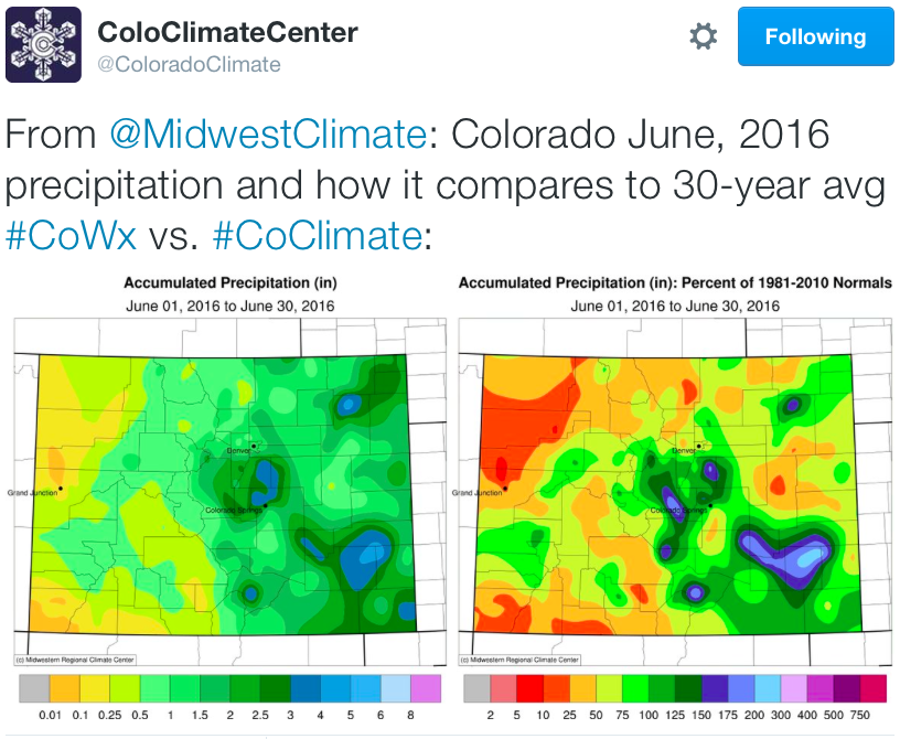
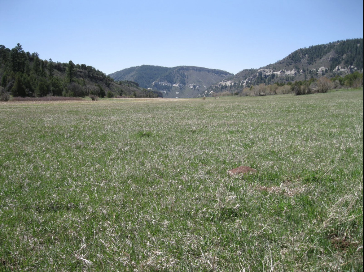
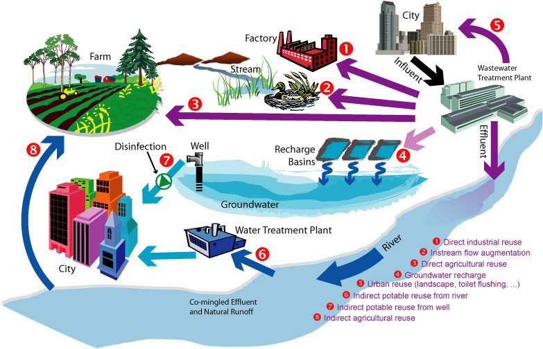
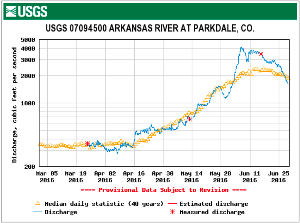

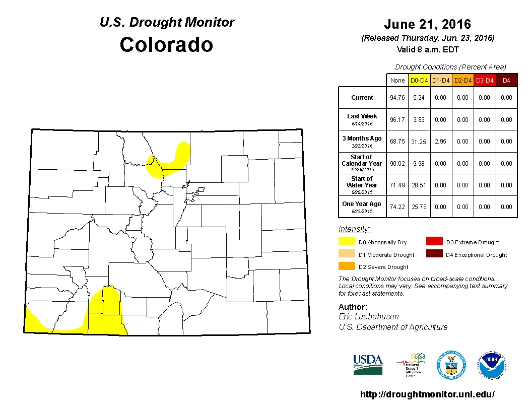
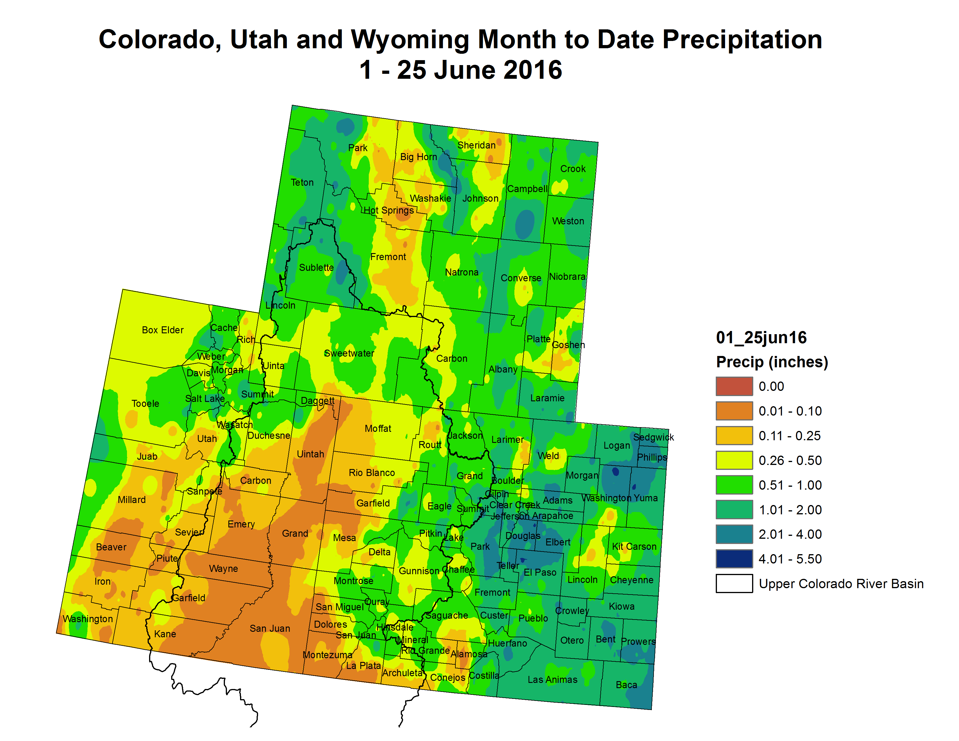


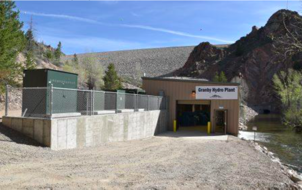

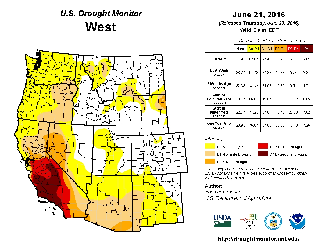


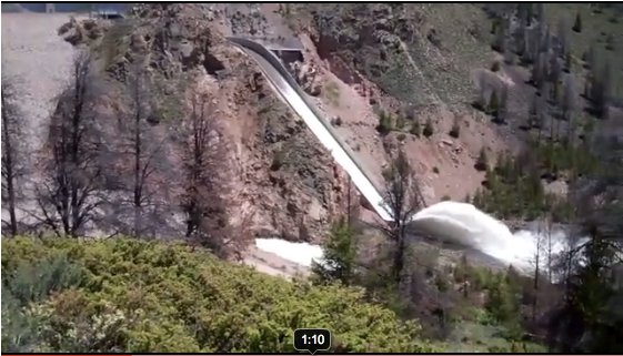


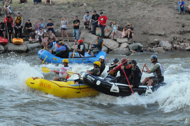

