
Day: June 17, 2016
After dam release, river runs through the Lower Dolores — The Durango Herald

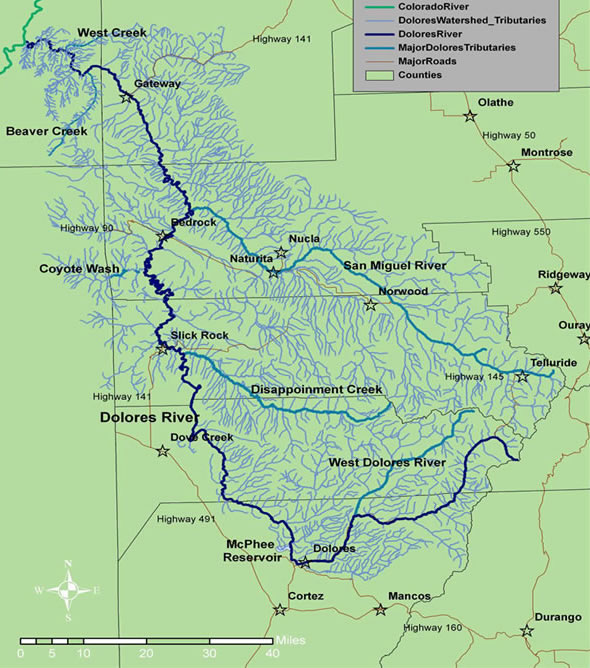
From The Durango Herald (Jonathan Romeo):
Overgrown banks, loads of sediment in the waterway and a depleted fishery cast a pale backdrop to an otherwise awe-inspiring float down the lower Dolores River, known for its deep canyons, lush ponderosa forests and seemingly endless succession of whitewater.
“And all of that is just a reflection of the channel starting to reflect the current hydrology,” said Colorado Parks and Wildlife aquatic biologist Jim White. “It has changed.”
[…]
Today, water out of McPhee Reservoir, considered the most expensive allotments in the Southwest, mainly supplies farms growing alfalfa, one of the most water-intensive crops used to feed cattle.
The divisive interests between farmers and recreationists have caused a debate over water rights to rage on for almost four decades.
A different riverSince the dam operates on a “fill, then spill” policy, enough water to float the lower Dolores River is only released when the dam is at capacity, and there’s no other place to store inflows.
That hadn’t happened since 2011 – until this year, when two small releases allowed boaters as well as wildlife officials to get an inside peek at what’s been happening to the long-neglected stretch of river.
And it didn’t look good.
The wildlife division’s White said a survey of the 19-mile stretch from Bradfield Bridge to the Dove Creek Pump Station found only 150 brown trout, a non-native species, and came up nearly empty-handed on native species.
“The loss of consistent spring flow to maintain habitat, coupled with altered base flow regimes, just all adds up to where we’re seeing reduced numbers of native species,” White said. “But what struck me, just the abundance of fish in general, native and non-native, is low through that part of the canyon.”
Another discernable transformation noted by many boaters was the unbridled vegetation that has started to bottleneck the river’s original channel. It was one of the most striking changes Sam Carter, board president of the Dolores River Boating Advocates, noticed on his trip this year.
“The overgrowth was intense, and dangerous,” Carter said. “There were two places that made it dangerous to move in a rapid.”
Carter said for the most part, this year’s release was a success: The large turnout of Dolores River aficionados worked together at boat launches, the weather made for hot days and warm nights, and the past year’s lack of access to the river left campgrounds, and the canyon in general, as wild as ever.
Yet a larger issues looms.
“This one spill is not the answer,” Carter said. “There has to be a change in the paradigm how that water is used. The river is getting killed. It’s a slow process, but it is happening.”
Is change possible?Mike Preston, general manager of the Dolores River Water Conservancy District, said at this point, it is “highly, highly unlikely” that any changes would occur to the management plan for the Dolores River.
Preston, a boater himself who took a trip on the Dolores River this year, said many farmers in the area made large investments setting farms up based on the water allocations.
“One boating day at 1,000 cubic feet per second is enough water to irrigate 1,000 acres for a full season,” he said. “And the farmers are paying us to maintain the facilities. And they also make payments to the federal government.”
Indeed, John Porter, a farmer turned Dolores Water Conservancy District manager who retired in 2002, said he’s clear in his bias for use of the river.
“There’s another side of it,” Porter said. “Do you just quit farming in this area and leave the water in the river? Until McPhee, it was dry river in the summertime because all the water was diverted. This project at least keeps it as a full-time river.”
Though the Dolores flowed anywhere from 800 to 1,500 cfs during the release, river levels throughout the year remain chronically low. In 2013, for instance, the river was at a trickle at just 13 cfs. The boating advocate’s president Carter said that doesn’t exactly constitute a healthy, flourishing river.
Carter said the group is “very actively” working on ways to secure annual releases out of McPhee for the benefit of recreationists and the environment.
“It’s not going to happen overnight, but we’re definitely working on it,” Carter said.
But for now, as the Dolores River slowly returns to its dispossessed flows, boaters look with a mixture of frustration and optimism toward next year.
“It was very much a bigger adventure than I think most people anticipated,” said Josh Munson, a board member of the Dolores River Boating Advocates. “Many longtime boaters noted the same things. It was faster, more wild. But the lack of water is really changing the characteristic of the river itself.
“When there isn’t a recreational release, it really isn’t much of a river.”
Pueblo Co. commissioners agree to keep funding CSU-Pueblo Fountain Creek Study

From The Pueblo Chieftain (Anthony A. Mestas):
Pueblo will continue to study Fountain Creek watershed.
The Pueblo County commissioners on Wednesday voted unanimously to help fund the project.
The school will receive $37,500 from the county to continue to conduct aquatic research along the creek to produce data to public entities for dissemination.
The commissioners said they have determined that it is in the best interests of the county to approve the request under the Aid to Other Entities Program.
The county has funds available in its budget appropriated and otherwise made available for payment to other entities to promote certain activities that would benefit or enhance the community.
“…peak #runoff is in the rearview mirror” — Matt Hildner

From The Pueblo Chieftain (Matt Hildner):
While most rivers and streams in the San Luis Valley now have steady flows, peak runoff is in the rearview mirror.
Despite recent years in which high-elevation snowpack has offered some surprises for state officials managing Colorado’s obligations under the Rio Grande Compact, this runoff is looking somewhat more predictable.
Assistant Division Engineer James Heath was in the high country above Rio Grande Reservoir last week to take a look.
“There’s some but it’s not a large snowfield that would have a significant impact on the production of the basin,” he said.
Predictability is a bonus in managing the compact, which has a sliding delivery scale that increases with higher flows on the Rio Grande and Conejos River.
Projected annual flow on the Rio Grande now stands at 700,000 acrefeet, which, if it holds, would call for a delivery of 204,000 acre-feet at the state line. So far this year, 105,400 acre-feet have been delivered to New Mexico.
The Conejos River and its tributaries in the southwestern corner of the valley have separate compact requirements.
Its projected annual flows sit at 305,000 acrefeet and would require a delivery of 112,800 acrefeet by year’s end.
The Conejos has delivered 58,300 acre-feet so far this year.
Since the 1968 settlement of a U.S. Supreme Court lawsuit, Colorado has imposed restrictions on irrigators to make sure compact obligations are met.
Currently, the restriction on the Rio Grande comes in the form of an 18 percent curtailment on the amount of available water. On the Conejos, curtailment is at 28 percent.
Long-term forecasts from the National Weather Service call for a wetter than average June and July but hot and dry conditions in late summer and fall.
From the Vail Daily (Scott N. Miller):
After a warm weekend that saw very high streamflows in places on area creeks and rivers, it looks like the streams have peaked. But those streams will still run high and fast for a while.
According to data provided by the Eagle River Water & Sanitation District, Gore Creek and the Eagle River above Avon have hit their peaks for the season. In addition, the snow measurement sites the district uses have either melted completely or are expected to by the weekend.
While the streamflows seem to have peaked — barring a severe thunderstorm or two that could cause isolated flooding — local streams are still running well above their average flows for this part of June.
As of June 12, the Eagle River at Dowd Junction was running at 217 percent of its normal flow for that date. Gore Creek above Red Sandstone Creek was running at 142 percent of normal — median flows over a 30-year period.
The high flows are good news for rafting companies. Sage Outdoor Adventures is the only local company that runs raft trips on Gore Creek. Those trips depend on healthy streamflows, and don’t happen every year.
Weather rules streamflow — heat shrinks high streams more quickly and cool extends flows — but Cole Bangert of Sage said it’s possible the company could be rafting the Gore until the end of June or so.
That will leave the Eagle River, but only for another few weeks, Bangert said.
But while local streams are running fast, Bangert said the Eagle River has some of the “best whitewater in the state.”
“There’s a stretch between Kayak Crossing (in Eagle-Vail) and Edwards that’s 10 miles of Class 3 and 4 rapids — it’s great,” Bangert said.
John Packer is the owner of Fly Fishing Outfitters in Avon. Packer said while local streams are largely too fast to fish, a solid runoff season is a benefit for those who want to cast a fly later this season.
“The runoff cleans out sediment, and stuff that comes off the roads, and moves it out of the system,” Packer said. “It improves aquatic insect habitat, and healthy bugs mean healthy fish.
Massive South Platte River flood of 1965 — 9News.com

From 9News.com (Erin Powell):
On June 16, 1965, South Platte River crested after three straight days of rain, which pushed flood water into local neighborhoods.
The flooding happened in four primary areas: north of Greeley and north and west of Sterling, the Plum Creek and Cherry Creek Basins, the Kiowa and Bijou Creek Basins and along the South Platte River from Plum Creek to North Platte, Nebraska.
According to the Littleton Museum, there had been little interest in building a dam, and the city did not anticipate a flood. The forecast showed scattered thunderstorms. In fact, storms in other places like Castle Rock and Larkspur pushed the water level over the edge…
More than 20 people were killed and 100 horses died at the Centennial Race Track. Twenty-six bridges and thousands of homes and businesses across Denver, Englewood and Littleton were ruined.
The damage totaled more than $500 million.
The Chatfield Damn (sic) was built in response to the flood, and completed in 1972.
Click through to view their photo gallery.
#AnimasRiver: Utah looking for link between San Juan River, Lake Powell water quality and #GoldKingMine spill

Eric Baker
From The Salt Lake Tribune (Emma Penrod):
State regulators are calling for more study of Lake Powell and sections of the San Juan River in light of unusual test results that may or may not be tied to last summer’s Gold King Mine spill.
Two sections of the San Juan River were added to the state’s list of “impaired” waters in the latest state water quality report. Those portions of the river were found to have concentrations of aluminum, cadmium, copper, iron, lead and mercury that exceeded state water quality standards on at least two occasions last fall.
The state also added portions of Lake Powell to the list — a move that greatly increased the overall percentage of freshwater lake acreage deemed as impaired, said Walt Baker, director of the Utah Division of Water Quality (DWQ). In the state report, released this week, 71 percent of Utah’s freshwater lakes did not meet the water quality standards for their designated uses, which include providing drinking water, recreation or wildlife habitat.
The overages in the San Juan River were detected by the Environmental Protection Agency while the feds were sampling the river to evaluate the fallout from the Gold King Mine blowout upriver, and are possibly related to the Aug. 5 incident, said Erica Gaddis, assistant director of the DWQ.
Gaddis said the department had feared this spring’s runoff could dislodge even more contamination and flush it downstream, but so far, the division hasn’t found evidence of that. And though portions of Lake Powell are listed as impaired, it’s unlikely that it’s related to the Gold King Mine, Gaddis said.
Water directly downstream of the mine saw decreased pH levels — becoming more acidic — immediately following the Gold King spill in August, but Lake Powell has had unusually high pH readings — a situation that itself is a mystery.
Now, the division’s scientists are also wondering where the estimated 880,000 pounds of heavy metals released during the August 2016 Gold King Mine incident ended up.
The common thought, Gaddis said, is that the metals were deposited in sediment somewhere upstream, on the Animas River in Colorado — and that they remained there, waiting for high river flows to flush them out.
It’s possible that those metals are already making their way downstream, she said, and increased river flow could be diluting the metals so that concentrations remain below the state’s screening values.
The potential for further contamination pushed the state to develop a long-term monitoring plan for the San Juan and Lake Powell, the likely final resting place for all that sediment, should it make its way farther down the river.
As part of that plan, the state has installed devices on the river capable of measuring the amount of sediment in the water in real-time. That data is available to the public at water data.usgs.gov.
It’s not yet clear how the amount of mobilized sediment correlates to the concentration of metals in the river. Gaddis said it could take another year for the DWQ to create a working model that will be used to issuing warnings when the river may be contaminated…
The primary concern, Gaddis said, is aquatic life. The state is also watching aquatic life in the region to determine whether metals in the river, or in the river’s sediment, are potentially harming fish or other creatures that live in the river. Gaddis said the DWQ has yet to see direct evidence of metals poisoning.
The long-term monitoring plan is anticipated to cost $1.2 million altogether, Gaddis said. So far the EPA has offered Utah $645,000 related to the Gold King Mine spill. Gaddis said the state intends to apply all of that money to its monitoring initiatives.
The state also intends to sue the EPA for its role in the Gold King Mine incident. Wade Fairway, an assistant Utah attorney general, told lawmakers during a Tuesday interim legislative meeting that his office was still in the process of hiring outside legal counsel to assist with the suit.
Meanwhile, Gaddis said, the DWQ has begun to turn its attention to the chronic effect of mining in the Bonita Peak Mining District in Colorado and on the San Juan River and its tributaries. The Gold King Mine alone, she said, could have released between 500 million and 850 million gallons of contaminated water over the past decade, and it’s just one of 48 old mines in the Bonita district.
The EPA proposed making the entire Bonita district a superfund site this past April.