The Mancos Water Conservancy District board voted to put up for lease 150 acre-feet of water from the Jackson Gulch project, district Superintendent Gary Kennedy said.
The board approved the water lease at their meeting June 14. District officials will be going out to see if people need extra water, though they might not need extra because of the wet spring season, Kennedy said.
The board and the Federal Bureau of Reclamation found agreement on project water rights for Jackson Reservoir, Kennedy said. The rights will be assigned to the water district from the federal government, he said.
Also at the meeting, the board discussed the title transfer for the project, Kennedy said. The title transfer is an ongoing issue that will take many years to resolve.
The district had hoped to complete some appraisals of land associated with the project this summer, but that hit a snag, Kennedy said. The cost for the appraisals is almost double what the board anticipated, and another government agency will be involved, he said. Even if the board decides to pay the new price for the appraisals, Kennedy could not say how long that would take.
The district is planning a party to celebrate 75 years of the water district. The celebration will take place July 16 at noon at Jackson Gulch Reservoir on Road N north of Mancos. There will be a barbecue as well as some educational information on the history of the district. RSVP is requested by emailing Kennedy at gary.mwcd@gmail.com or calling 970-533-7325.
District officials also will be working on clearing the inlet canals to the reservoir this summer, Kennedy said. The reservoir’s two drop chutes also need some work, but that might not take place until 2019, when the district could receive money from the federal government to rehabilitate the chutes, Kennedy said.
Board member Boe Hawkins was reappointed to a four-year board term at the meeting.
The reservoir’s jet valve was rebuilt over the winter, and some safety issues came up with the valve, Kennedy said. After investigation, the valve was operating normally and there were no major problems, he said.
The hydro lease of the power permit for the project is still moving forward and the board is still working on it, Kennedy said. At next month’s board meeting July 12, board members will elect officers.
The Widefield Water and Sanitation District said while their PFC levels are not too far above the limit.
During a public meeting this afternoon, they suspected firefighting foam used at Peterson Air Force base years ago could be the culprit.
Perflourinated chemicals, also known as PFCs, were found in wells in Security, Widefield and Fountain.
That prompted a health advisory for pregnant women and babies, and that concern is spreading…
The Air Force started using PFC based firefighting foam in 1970 to put out fuel based fires and told us they stopped using it about 10 years ago.
A map outlines where PFC foam was used at nearby local military installations in relation to Security and Widefield.
Fort Carson told us, their one fire training site will be tested in the near future. But, added their water couldn’t have moved uphill to the affected area.
Peterson Air Force Base told us, they just tested their two fire training sites. Those preliminary results will be public in the next few months. They are scheduled to have the sites tested again in May 2017, but said, based on the results of the preliminary test, that date could be moved up.
That’s where Widefield believes their problem begins.
In May 2016, the EPA and Colorado Department of Public Health and Environment (CDPHE) lowered the allowed limit of PFCs in the water.
Widefield Water said more than 60% of their water has no traces of PFCs. And before the new guidelines, they were well below the accepted levels.
In security, the PFC levels tested much higher than Widefield’s. The water department there said it could be decades before the chemicals work their way out of the water supply.
“It made me immediately stop using everything- ice included. I don’t want another Flint happening here,” Security resident Latisha Mapu previously told us.
Widefield Water said they hope to have a plan ready to fix the problem in the next few months.
In the meantime, they said homeowners can install a reverse osmosis system or use carbon water filters in the home.
For a look at the affected areas in Security, Widefield, and Fountain click here.
For Colorado Springs Utilities customers and Pueblo Water Works customers, they told us this issue wouldn’t happen because those utilities get their water from places like Pueblo Reservoir and not well water.
Members of the Widefield Water District held a public meeting this week, where citizens asked many questions. The most common question asked, was how people can protect themselves.
“You can get an activated carbon filter and a reverse osmosis filter,” said Brandon Bernard with Widefield Water District.
The different filter options cost anywhere from $30 to $500.
“Make sure the filters are NSF (National Science Foundation) approved, and follow all the recommended guidelines when you purchase your filter,” Bernard said.
But the idea of filters isn’t easing everyone’s mind…
Water district members say Widefield does not have a higher rate of cancer or developmental issues compared to anywhere else in Colorado.
“Widefield is going above and beyond, we’re improving our blending stations and looking into future treatment options,” said Brenard.
Meanwhile, local water companies are seeing a sudden spike in bottled water sales.
“This is by far the most interest in bottled water that we’ve seen here by far,” said Rick Baker, co-owner of Springs Mountain Water in Colorado Springs…
In just two days the business sold one month’s worth of water jugs.
The Earth passed another unfortunate milestone May 23 when carbon dioxide (CO2) surpassed 400 parts per million (ppm) at the South Pole for the first time in 4 million years.
The South Pole has shown the same, relentless upward trend in CO2 as the rest of world, but its remote location means it’s the last to register the impacts of increasing emissions from fossil fuel consumption, the primary driver of greenhouse gas pollution.
“The far southern hemisphere was the last place on earth where CO2 had not yet reached this mark,” said Pieter Tans, the lead scientist of NOAA’s Global Greenhouse Gas Reference Network. “Global CO2 levels will not return to values below 400 ppm in our lifetimes, and almost certainly for much longer.”
South Pole carbon dioxide record Daily average carbon dioxide levels rose to a new high level of 400 parts per million on May 23 for the first time in four million years. This chart shows readings at the South Pole from 2014 to present, as recorded by NOAA’s greenhouse gas monitoring network. Credit: NOAA
Over the course of the year, CO2 levels rise during fall and winter and decline during the Northern Hemisphere’s summer as terrestrial plants consume CO2 during photosynthesis. But plants only capture a fraction of annual CO2 emissions, so for every year since observations began in 1958, there has been more CO2 in the atmosphere than the year before.
Last year’s global CO2 average reached 399 ppm, meaning that the global average in 2016 will almost certainly surpass 400 ppm. The only question is whether the lowest month for 2016 will also remain above 400.
Upward trend continues
And the annual rate of increase appears to be accelerating. The annual growth rate of atmospheric carbon dioxide measured at NOAA’s Mauna Loa Observatory in Hawaii jumped 3.05 ppm during 2015, the largest year-to-year increase in 56 years of monitoring. Part of last year’s jump was attributable to El Nino, the cyclical Pacific Ocean warming that produces extreme weather across the globe, causing terrestrial ecosystems to lose stored CO2 through wildfire, drought and heat waves.
Last year was the fourth consecutive year that CO2 grew more than 2 ppm – which set another record. This year promises to be the fifth.
“We know from abundant and solid evidence that the CO2 increase is caused entirely by human activities,” Tans said. “Since emissions from fossil fuel burning have been at a record high during the last several years, the rate of CO2 increase has also been at a record high. And we know some of it will remain in the atmosphere for thousands of years.”
For more information, please contact Theo Stein, NOAA Communications, at theo.stein@noaa.gov or by telephone at 303-497-6288.
Better management and use of existing dams is a key tool to minimize new expensive, energy-consuming, and environmentally damaging large scale new dams or diversions from the West’s rivers.
We are a conservation group with a priority goal of saving rivers in the West. So you would think we would be opposing anything to do with dams. But the reality is that we believe that better management and use of existing dams is a key tool to minimize new expensive, energy-consuming, and environmentally damaging large scale new dams or diversions from the West’s rivers. Which brings us to today’s story about supporting more creative management of Chatfield Reservoir and saving Plum Creek.
The U.S. Army Corps of Engineers recently approved storing more water in Chatfield Reservoir on the South Platte River southwest of Denver to help meet Colorado’s existing and growing water needs. Western Resource Advocates, Conservation Colorado, and the Rocky Mountain Chapter of the Sierra Club support this decision because it follows the Smart Principles of water supply management by making more efficient use of existing reservoirs and local water supplies. In our view, select new-supply projects—including holding more water in the existing Chatfield Reservoir—high rates of water conservation, accelerated water recycling and reuse, and voluntary sharing of water with agriculture for other uses all can combine to meet and exceed 2050 water demands for the South Platte Basin. “Chatfield Reallocation” exemplifies the opportunities available to state water planners to meet reasonable anticipated water needs without building more costly, politically charged, large-scale concrete and steel water project proposals that cause major harm to rivers.
However, putting more water in Chatfield Reservoir will still harm wildlife habitat provided by nearby wetlands and cottonwood stands. These habitat areas are accustomed to a lower, and less variable, water table in the reservoir. As part of the agreement to re-allocate water storage space in Chatfield reservoir, the environmental impacts must be offset, or “mitigated,” through replacement and permanent protection of other wetlands and other important wildlife habitat. To this end, the project’s beneficiaries have deposited approximately $130 million into a special bank account dedicated to environmental and recreational mitigation. Western Resource Advocates is joined by representatives of relevant state and federal agencies and other stakeholders as a member on the Technical Advisory Committee for the Chatfield Reservoir Reallocation Project, which guides implementation of the environmental protection and restoration mitigation projects.
At its first meeting in late April, the Committee urged the mitigation company to use some of the mitigation funds to address rapidly deteriorating wildlife habitat along Plum Creek, which is above the reservoir in the park. Urban development in the Plum Creek watershed has significantly increased rain runoff flows that are scouring a deep channel into the creek bottom, and in turn, lowering the water table and draining high-quality wetlands next to the creek. This erosion, called a “head cut,” is unrelated to the Chatfield water storage project.
This year, the head cut in Plum Creek is advancing dozens of feet upstream with each rain storm. Western Resource Advocates and the Committee unanimously urged the mitigation company to stabilize the creek and stop the head cut. This will help restore Plum Creek’s health and provide good creek-side habitat for birds and other wildlife.
Mitigation projects like this one on Plum Creek demonstrate the potential of creative water supply solutions, including Chatfield Reallocation, to meet communities’ water needs and to fix significant local and regional environmental challenges. It also illustrates how dynamic mitigation projects can be since few anticipated that this habitat would, on its own, deteriorate so badly in such a short period of time. Without mobilizing the mitigation funding made possible by this project, Plum Creek’s wetlands might be lost for generations. Stay tuned to the Chatfield Reallocation Project as the stakeholders develop and implement this and other exciting protections for wetlands and rivers.
Rob Harris is a Western Resource Advocates attorney representing WRA, Conservation Colorado, and the Rocky Mountain Chapter of the Sierra Club on the Technical Advisory Committee for the Chatfield Reservoir Reallocation Project.
As befits a western land-grant institution, Colorado State University has a long history of leading water science and policy research. And over several decades, many CSU alumni – mostly from the College of Engineering – have taken prominent positions across the globe, delving into water resource and management issues on every continent.
Many of these alumni were welcomed back to campus for the 2016 Water and Climate Initiative, June 13-14. Over the two-day summit, they pooled their expertise and vision, and provided a comprehensive list of suggestions and needs to guide water resource management globally. They also provided a slate of recommendations to Colorado State University to further refine research goals around water and climate issues.
The initiative took place at the Durrell Center at CSU. It was hosted jointly by the College of Engineering, the Cooperative Institute for Research in the Atmosphere (CIRA, a partnership between CSU and the National Oceanic and Atmospheric Administration), and Riverside Technology, Inc., a Fort Collins-based science and information technology company.
Keynotes underscore wealth of expertise
Keynote presentations ranged from climate and hydrologic forecasting and water crisis management in Asia and South America, to best practices for regional water management and observation of water resources. A focus on education needs in particular fostered debate and brainstorming. Participants, the majority of whom studied or worked at Colorado State University, came from around the country, as well as from four continents including dignitaries from Iceland, South Korea, Brazil, Egypt, and the Gulf Region of the Middle East.
Participants, many of whom hold high office in governmental or international water councils and agencies, broke into focus groups to craft position statements on the needs and suggestions of critical topics, including hydrologic uncertainty and extreme events; politics, people and governance; and water management and planning.
Suggestions and needs ranged from technical improvements in utilizing climate model outputs for hydrological modeling, and improvements in statistical analysis and investigation of major flood events, to integration of a country’s workforce and economic sectors to better influence management and infrastructure. Also discussed were philosophical and practical ways to balance financial sustainability and social justice, and how subsidies and distribution of water resources are administered, with a special interest in low-income regions.
Five-point recommendation
The initiative was facilitated by the dean of CSU’s College of Engineering, David McLean, along with Reagan Waskom, director of the Colorado Water Institute; Chris Kummerow, CSU professor of atmospheric science and director of CIRA; Larry Brazil, president and CEO of Riverside Technology, and Neil Grigg, CSU professor of civil and environmental engineering.
Dignitaries and workshop participants, including three CSU graduate students, presented a summary five-point recommendation to CSU Provost Rick Miranda, suggesting that CSU research efforts in water and climate could:
focus on integrating knowledge across climate, water, ecology and humans;
focus on research in climate forecasting and early warning tools related to hydrologic processes;
exploit global data and information to promote integration and decision support;
advance the university service and outreach mission through vigorous international scientific cooperation;
hire faculty using joint appointments, and allow graduate students to obtain interdisciplinary degrees in “water” to further integrate across disciplines.
Summary remarks by Miranda reiterated CSU’s commitment to leading the world in water resource and climate research expertise. Needs identified during the summit are critical, he said, in continuing the university’s tradition of excellence in teaching, research and outreach.
During the Colorado Cattlemen’s Association annual convention last week in Colorado Springs, ranchers, business owners and ag officials discussed the ways the state’s cattlemen can make a difference in water conservation and why the beef industry needs to have a role in the conversation. Many ranchers grow feed crops for their animals, like hay or grains, rather than purchasing them. Nearly all have to worry about water when it comes to the quality of their pasture and rangeland. Even for those that rely on purchased feed or who graze on federal lands, Fankhauser pointed out that the ag industry is all interconnected.
Fankhauser asked the group: If corn dries up, what will cattle eat? If farmers start to go out of business in an area, feedlots move out, then packing plants move out, Fankhauser said. When ranchers can’t keep the water on their land to sustain their pastures, they have to sell off their cattle herd, as they did in the 2012 drought.
Bill McKee, a rancher who lives in Carbondale but runs cattle in both Carbondale and Platteville, said if the beef industry does nothing else, it needs to make an effort to stop buy-and-dry, a practice in which agricultural land is bought up for its water rights and taken out of production…
Through water leasing, farmers would maintain ownership of their water, but only use a portion of it and be paid for the rest, which would be used by someone else, like a municipality…
There are a few different ways this could look, but according to a survey done by the Ag Water NetWORK, an organization formed by the Colorado Cattlemen’s Association and the Partners for Western Conservation, the most popular of them is for a certain portion of water to be leased, then the producer would receive reduced delivery of water over the rest of the season. About two-thirds of the respondents to the survey expressed some sort of interest in leasing their water…
T. Wright Dickinson, former president of the Colorado Cattlemen’s Association who serves on the state’s Inter-basin Compact Committee, said ag water leasing is only part of the solution. Continued development of the reservoir storage system is necessary, too, but ranchers need to realize their role and the opportunities they have to manage their water in a way that protects ag’s viability.
“If we do it right, conservation goes a long way into solving some of this gap,” said Dickinson, a Moffat County rancher. “If we do it wrong, the state won’t look the same.”
At the convention, Carbondale and Platteville rancher McKee talked with representatives from conservation group Trout Unlimited, which works with farmers and ranchers on water management to benefit fish populations. He was looking into options to better handle water on his property, something he said he needs to do soon, because changes are coming to Colorado, and they’re coming faster than anyone is prepared for.
“It’s time to have an intelligent discussion,” he said. “Everybody should be looking at these issues.”
Stephanie Scott, outreach coordinator with Trout Unlimited, said she sees the conversation around water and other natural resource issues changing in the ag community every time she attends a convention like the Colorado Cattlemen’s Association’s. At first, ranchers hesitate when they see the Trout Unlimited booth. It’s nestled next to the trade show mainstays, like merchandise, livestock products and ag tech. Scott said she can see the questions in their eyes — the ones they’re afraid to ask a conservation organization.
Trout Unlimited want to help them better manage their water because it helps both the farmer and the organization accomplish their goals, Scott said. Once farmers and ranchers realize that, the conversation about conservation really gets going.
And as population grows and the pressure on water mounts, more people in the ag community — the whole ag community, not just traditional crop growers — are willing to try new things, Scott said.
Since the governor’s water plan is new and fresh on the minds of legislators, McKee said now is the time for ag to have a bigger part in water conversations.
“Ag has to be on equal footing with municipal and industrial and environmental concerns,” he said. “We have to be at the head of the table, not at the end of the table.
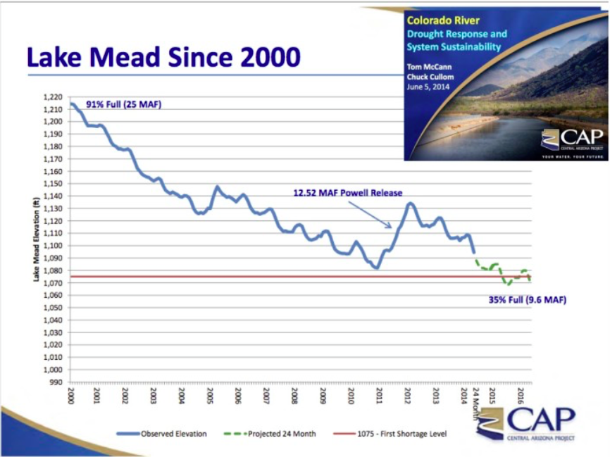
Runoff on the Colorado River this past week has pushed Lake Powell to its highest level in four years. When the runoff ends in early July, the lake will be near 3,620 feet above mean sea level (msl).
Even though runoff in 2016 was slightly below normal it was enough to boost Lake Powell 30 feet from the spring low in April. By July, the lake level will be 65 feet higher than April 2005 when the lake dropped 145 feet below full pool.
As sure as winter snows give way to spring runoff each year to replenish our rivers, lakes and waterways, Lake Powell naysayers have flooded the opinion pages of newspapers with drain-the-lake propaganda. The reality is that Lake Powell has continued to hold its own for over a decade now and continues on a quiet upward trend toward the lake’s normal 50-year elevation of 3640 feet msl.
“Some good news is that despite 15 years of drought, Lake Powell is storing more than 4.3 trillion gallons of water and the reservoirs above Lake Powell in the Upper Colorado River Basin have filled to near 90 percent of capacity,” said Tiff Mapel, Friends of Lake Powell spokesperson…
“The silent but important statistic is that Lake Powell has provided extra water to Mead in five of the past 10 years, including the giant release of 12.5 maf in 2011,” Mapel said.
These increased flows have pushed the 10-year rolling average of Upper Basin deliveries to 89.4 maf – significantly more than the obligated base flow of 82.3 maf. The difference is almost an extra year’s worth of water.
If Lake Powell is rising, why does Lake Mead continue to drop?
Eric Kuhn, general manager of the Colorado River Water Conservation District, recently reported the problem is that Lake Mead continues to operate with a water budget deficit of up to 1.2 million acre-feet per year.
This deficit exists because of water delivery inefficiencies and evaporation in the Lower Basin. Lake Mead releases more water downstream than is actually allocated to California, Arizona and Nevada because of timing and other delivery inefficiencies. In addition, Lake Mead and the other downstream lakes, located in the hot Mojave Desert where temperatures can soar to 120 degrees, experience an evaporation rate that can exceed 0.6 million acre-feet per year. Together, these operating losses result in a water deficit for the Lower Basin that approaches 1.2 million acre-feet per year.
To make up for this water budget deficit, the Lower Basin has traditionally relied on wet hydrological events in the Rocky Mountains to periodically fill and then overflow the Upper Basin reservoirs sending additional water cascading all the way down to Lake Mead. This occurred in the mid-1980s and then again in the late-1990s which helped to replenish the Lower Basin system of reservoirs.
Today as Lake Mead continues to drop, the Upper Basin is doing its fair share to increase water deliveries downstream in accordance with existing reservoir-operating criteria between the two basins. However, the additional deliveries by the Upper Basin have largely been lost in the negative media stories about the Colorado River and the ongoing drought.
“The real concern of the Colorado River is the failure of the Lower Basin to account for its system delivery losses and the continued reliance of overflowing water deliveries by the Upper Basin during times of hydrologic plenty,” Mapel explained. “With economic stakes high, it is a risky gamble and a choice not considered sustainable in light of ongoing drought conditions.”
Droughts do tend to go in cycles. The multi-year Texas drought turned to flooding conditions in 2016. The fickle nature of the Colorado River and the need to store water in reservoirs during periodic wet periods was not lost on our forefathers. When there is abundant rainfall and the reservoirs are full, the infrastructure on the Colorado River may seem redundant but water managers rely on this stored water to make up the difference when the heavens don’t cooperate.
“Lake Powell is doing exactly what it was intended and designed to do,” said Marlon Duke, spokesperson for the Bureau of Reclamation’s Upper Colorado Region. “It is storing water for Upper Basin states and helping ensure the Upper Basin can meet its obligation deliveries to the Lower Basin without curtailing entitled use by Upper Basin water users.”
In the late 1990s, when Lake Powell and Lake Mead were both full to near capacity, environmental groups hoping to drain Lake Powell floated the notion that two large reservoirs on the Colorado River were redundant and unnecessary. They considered Lake Mead large enough to withstand a severe drought. They also claimed that keeping Lake Powell full could result in a catastrophic dam failure with significant loss of life and property downstream.
In retrospect, it was simply another self-serving attempt to drain Lake Powell and restore Glen Canyon.
“When the climate tables turned in the year 2000, the folly of this proposal became apparent,” Mapel said. “Thank goodness we had Lake Powell. Simply put, Lake Powell is a critical asset. It has kept Lake Mead from running empty and it also provides important regional recreational resources.”
The notion to drain Lake Powell is a shallow idea that ignores important economic, political and resource consequences. According to officials at the Bureau of Reclamation, the loss of hydropower from Glen Canyon Dam would have a major negative impact to the western power grid and compromised rural electric rates. The revenue loss for the Upper Basin would, undermine repayment schedules for irrigation projects in the Upper Basin and reduce funding for salinity control efforts, improvements to aging irrigation systems and jeopardize existing endangered fish recovery programs.
Additionally, draining Lake Powell would destroy a thriving and important regional economic engine. Arguably the most scenic lake in America, Lake Powell attracts millions of people each year to its inviting waters, the scenic landscape, comfortable Colorado Plateau temperatures and an unbounded sense of adventure. Lake Powell is a world class experience that offers a multitude of experiences including recreational boating, exploration of 96 lush and scenic canyons, wakeboarding, kayaking, camping, photography and outstanding fishing opportunities whether on the lake or the downstream cold water, blue-ribbon trout fishery at Lees Ferry.
The team is injecting fluorescent, non-toxic, green dye into water that flows into the collapsed mine shaft on Illinois Gulch Road above Breckenridge. They’re then observing and sampling the water downstream to see how much of the water filters through the mine and emerges on the other side. The hill has been mined all the way through and is rife with tailings and collapsed mine shafts. Contaminated water — a toxic tangerine from heavy iron — trickles out of the mine openings and along the ground, staining the dirt and rocks in its path.
“Basically, the study is to figure out how the water is draining from the mine sites,” said Katherine Jenkins of the Environmental Protection Agency (EPA).
A group of partner agencies is managing this several dayslong water tracer study at the Puzzle Willard Mine. The Illinois Gulch Tracer Study — led by Colorado Department of Natural Resources Division of Reclamation Mining and Safety and assisted by the Colorado Environmental Protection Agency, the Colorado Department of Public Health and Environment, the U.S. Fish and Wildlife Service, Trout Unlimited, the U.S. Geological Survey and the U.S. Forest Service — is being conducted to trace the path of water flowing in creeks down Boreas Pass through the mine and out three adits, or openings.
At each of the adits downstream, there is an automated sampler that tests for traces of the dye every few hours. After the injection of the dye into the mine site on Monday morning, the team will spend the next 7-10 days testing the water on the other side of the mine for traces of the dye, to see whether the contaminated water was making its way into the surface water in the Illinois Gulch drainage.
Peter Stevenson, of the EPA, explained that the mine runoff presents no danger to the drinking water of Breckenridge residents. He said the water sources for the town are located in other drainages, and everyone who lives up near Illinois Gulch Road uses Breckenridge water. However, a small amount of this water could make its way to Lake Dillon. The stream that runs through the mine is the headwaters of Iron Springs, which feeds into Blue River and then the lake.
At this point in the process, the investigation is intended to establish a baseline of the water quality at the site and then use the data to determine what further steps must be taken.
“After we figure out where the water goes, then we’re going to come together with all of our partners and try to figure out what the next step is,” said Jean Wyatt of the EPA. “We’ve done fish studies, we’ve done macro-invertebrate studies and we’re still compiling all that data,”
When the amount of water that is actually running through the mine is found, the group can assess the situation and determine whether steps need to be taken and, if so, what the best method is for preventing the water from reaching the metals in the mine.
“We have a lot of sampling data from over the years. We need to compile it and review it and look at it. This is a piece of a multi-year assessment,” said Stevenson.
The research team is leaving all its options for mitigation open until this assessment is complete, but they do have an expectation of what may happen to the mine tailings in the area that are not sitting in the drainage water.
“Ultimately, I would expect this to get shaped and capped somewhere nearby,” said Stevenson
In May, the agency reduced the levels for allowable contamination by perfluorinated chemicals from 0.4 micrograms per liter to 0.07 micrograms per liter, almost 10 times less. The advisory only provides technical guidelines to states and regulation isn’t mandatory, however it has had a great impact in Security.
“The EPA lowered the standards below what we had anticipated; and then the problem was the new health advisory was so much more stringent that none of our wells would meet them,” Heald said. “Different people have different concerns. The health advisory is protecting the most sensitive members of the population — pregnant women, fetuses, infants…I’m a healthy middle-aged male so I feel my risk is low. But I understand that others rightfully have concerns.”
Well water has been most affected by the advisory; Heald said that supply is largely being replaced by surface water. However, he adds that there’s not enough at present to meet peak demand — and water usage is as much as five times greater during the summer.
Wells have been shut down and other steps, like the installation of new pipes and building filtration structures, are underway. The problem is paying for them. Heald says the cost will eventually have to be passed on to customers.
“We’ve been asking for help from anyone who will listen for some financial support but no one has offered,” he said. “There’s no party that’s been found to be responsible for the contamination, so no one’s stepped up to pay for this.”
“All of our water meets all federal and state drinking water standards,” said Roy Heald, general manager of Security Water and Sanitation Districts. “In other words, it meets all the regulations. This is an EPA health advisory, so it doesn’t rise to the level of a regulation. It just advises us and the public to be cautious.”
Heald said if you’re concerned, you “may want to consider a different source.”
In light of the advisory, Security has closed seven of its wells. One of them tested at a level of 1,300 parts per trillion of PFCs.
The Environmental Protection Agency’s new regulation is 70 parts per trillion.
However, Heald said residents never got that amount because the water was diluted.
Security also gets its water from surface water in the Pueblo Reservoir, which is what Heald said the community is mainly relying on for now.
However, only certain residents are affected. The area is split into three regions…
Security’s water department didn’t say when the problem would be fixed, but said it could take a long time before the chemicals are out of the system.
“We’re looking at treatment over the long term because I think over the long term it’s going to be decades or maybe even generations before these chemicals work their way through the aquifer,” said Heald.
Man-made PFCs have been in the ground water for years in the communities south of Colorado Springs, but last week the EPA lowered the safe level of contamination and put them in the danger zone. Now residents are paying out of pocket for bottled water and filters for their homes, which they say is not fair.
Families in the three communities are already feeling the impact of PFCs in the water. Stories are coming out on the petition page about health problems possibly linked to the contamination. Cancer, elevated cholesterol and birth and developmental defects are among the CDC’s listed effects…
Right now residents are buying clean water to use for drinking, cooking and bathing multiple times a week, in addition to paying their water bills, and say they should not have to. Loudenber says, “You’re talking single moms. You’re talking families that are already on assistance. They can’t afford to go get bottled water every few days.”
The EPA is encouraging people with wells in those three districts to make appointments to get their water tested. The local water districts are only advising pregnant women and breastfeeding mothers to avoid the tap water. They continue to investigate the source of the PFCs, but Peterson AFB confirms they used firefighting foam that contained the chemicals up until 2002.
Still, people like Loudenber want action now. “I’m not saying it’s the water district’s fault,” she says. “Obviously it came from somewhere else, but it’s here now. We need to deal with it.”
In addition to the request for free water bottles and filters for neighbors in the three communities, she hopes the water districts implement a free long-term fix for the wells there. “There are filters out there that they can put on the wells that will help with the PFCs,” Loudenber says. “They just have to be willing to do that.”
Care and Share Food Bank will hold a meeting in the coming days to asses their supply of bottled water, and see if they will be able to get more if the water districts do not take action.
When News 5 spoke with Security Water District on Monday, representatives said they had not heard about the petition and would not provide a comment. They did say the district was already mixing more surface water into the supply that does not contain PFCs.
Widefield aquifer via the Colorado Water Institute.
To look at the numbers, you’d expect to see otters frolicking everywhere in the Arkansas River basin.
Then you realize that the nearly 10,000 storage vessels in Southeastern Colorado are spread over more than 28,000 square miles in mostly arid or semiarid areas. Then consider that many of the reservoirs are seldom full. Finally, the vast majority are pond-sized, not lakes.
Still, someone has to keep an eye on them all, because water stored in them rightfully belongs to someone else. In the past 10 years, there have been 79 orders issued by the state in relation to improper storage practices.
“The Arkansas River is a big basin, and there’s a lot of complexity in the basin,” Assistant Division Engineer Bill Tyner told the Lower Arkansas Valley Water Conservancy District last week. “We put our emphasis on the top 200 structures.”
Tyner then walked the board through the different types of reservoirs that are known to exist. Even that can be a problem to determine, because reservoirs are man-made, while natural features such as lakes, ponds or wetlands on a creek might show up in aerial photographs.
There are more than 1,500 decreed structures in the Arkansas Valley, although some may not be in use or are restricted.
Of those, only 20 hold more than 10,000 acrefeet (3.25 billion gallons), and another 169 hold more than 100 acre-feet.
The rest are there, legal to use, but subject to water rights administration. In other words, they cannot store water if a user with a senior appropriation right is calling for the water downstream.
The largest reservoirs are John Martin Reservoir, which was built for flood control and to settle interstate compact differences between Kansas and Colorado, and Lake Pueblo, which was built as part of the Fryingpan-Arkansas Project for water supply, flood control and recreation.
There are nearly 1,800 erosion control dams, which must be under 15 feet in height, store less than 10 acre-feet and can be drained in 36 hours. They have to be dry 80 percent of the time.
“There are a lot of these at the Pinon Canyon Maneuver Site to mitigate vehicle damage,” Tyner said.
As would be expected, erosion control dams are found in the hilly areas of the basin in the Upper Arkansas, El Paso County and the Spanish Peaks area.
There are more than 5,400 livestock tanks, which fall under a specific state statute that has the same criteria as erosion dams, but also sets a chronological priority within the same drainage.
“Livestock ponds have a seniority system, but it’s not as formal as a decreed right,” Tyner said.
Gravel pit ponds are a different category. There are about 750. The ponds intercept groundwater because of activities by humans, so must be augmented to replace evaporation losses. Those are most common on the Eastern Plains, where gravel mining is prevalent.
There are roughly 140 head stabilization ponds, which are limited to storing water up to 72 hours, by state policy, primarily to reduce sediment for sprinkler or drip irrigation.
Aside from the known reservoirs, there are unknown storage systems including post-wildland fire facilities, stormwater detention ponds and unregistered ponds used for erosion control, livestock or head stabilization.
A rendering from Wilderness Workshop of a potential Maroon Creek Reservoir, which would hold 4,567 acre-feet of water behind a 155-foot-tall dam. The rendering was prepared by a professional hydrologist and is based on plans submitted to the state by the city.
ASPEN – Officials at the city of Aspen intend to hold at least one public meeting this summer to discuss the conditional water rights it holds that are tied to potential dams on upper Castle and Maroon creeks.
The city’s next diligence filing for its conditional water rights for the two dams and reservoirs is due in Division 5 water court in Glenwood Springs by Oct. 31. It’s highly unusual in Colorado for a city, or any other entity, to hold a public meeting on a pending diligence filing.
David Hornbacher, city of Aspen director of utilities and environmental initiatives, said that while holding a public meeting is indeed “different,” he is acting at the direction of the city council.
“These are important questions,” he said. “And it’s very much about looking into the future and how do we ensure Aspen has what it needs to continue to thrive and be the place that it is, and what’s the best approach.”
Paul Noto, a water attorney with Patrick, Miller and Noto, which specializes in water law and has represented many clients in the Roaring Fork River watershed, said it was “very unusual” for a city to hold a public hearing about a pending diligence filing.
“I’ve never heard of it, although that’s not to say it’s never occurred,” Noto said. “I’ve just never heard of it.”
A rendering from Wilderness Workshop showing the potential Castle Creek Reservoir. The rendering was developed by a professional hydrologist and i sbased on engineering plans filed by the city.
15-story dams?
If built as currently described by the city’s plans, which were first presented to a water court judge in 1965, the Maroon Creek reservoir would store 4,567 acre-feet of water behind a 155-foot-tall dam just below the confluence of East Maroon and West Maroon creeks.
While only about a third of the size of Paonia Reservoir, which can hold 15,553 acre-feet when full, a Maroon Creek reservoir would still cover 85 acres of U.S. Forest Service land about a mile-and-a-half below Maroon Lake.
It would also inundate portions of both the East Maroon Creek and West Maroon Creek trails in the Maroon Bells-Snowmass Wilderness.
The Castle Creek reservoir would hold 9,062 acre-feet of water behind a 170-foot-tall dam located about two miles below the historic town site of Ashcroft.
It would inundate 120 acres of mostly private land between Fall Creek and Sandy Creek and flood a small piece of Forest Service land within the Maroon Bells-Snowmass Wilderness.
Both reservoirs would be located in Pitkin County.
Since 1965, the city has told the state eight different times it intends to build two large dams in pristine locations in the upper Castle and Maroon creek valleys, and it is on the record that the city intends to file a diligence application this fall. In its September 2009 diligence filing the city told the water court “it has steadily applied efforts to complete” the reservoirs “in a reasonably expedient and efficient manner.”
A court official, known as a water referee, agreed.
“To date, the city of Aspen has not needed to construct the storage structures as it has devoted considerable resources to reducing per capita water consumption,” the unnamed referee wrote. (Please see related story).
A rendering from Wilderness Workshop showing how a Castle Creek Reservoir might look on a seasonal basis after water has been drawn done to meet downstream needs.
Private and public meetings
Hornbacher said this week he will hold one private meeting with stakeholders in early July about the dams and at least one public meeting in July or early August, “depending on the level of public interest.”
After presenting information about the water rights and taking questions and suggestions at the meetings, Hornbacher said he would report back to the council in a work session in August or September to get its direction by the Oct. 31 filing deadline.
He said council could direct staff to proceed with the diligence filing and try and keep the water rights on the books for another six years.
Or it could direct staff not to file, or to file a modified application.
Hornbacher said a modified application could mean filing on one dam and reservoir, but not both, or it could mean filing on both reservoirs but changing their size and shape.
It’s not unheard of for entities to walk away from conditional water rights. The Colorado River District made the decision to abandon rights for two large dams on the Crystal River in 2013. And over the last five years, the district has stepped away from a number of other conditional water rights.
Among the stakeholders Hornbacher plans to invite to a private meeting are Wilderness Workshop, Roaring Fork Conservancy, U.S. Forest Service, and Pitkin County.
Wilderness Workshop first reported the city’s decision to hold public hearings in a newsletter it sent to members on June 1. The headline of the article read, “Potential dams on Maroon and Castle creeks still on the books” and a subhead read, “A diligence filing this fall would keep them alive; WW says, ‘No way!’”
The city of Aspen intends to hold at least one public meeting on the conditional water rights it holds for two large dams, one on upper Castle Creek and one on upper Maroon Creek, shown here in this 2012 file photo, with the Maroon Bells visible in the background. The dam on Maroon Creek would be 155-feet-tall and store 4,567 acre-feet of water.
Proving diligence
Typically, owners of conditional water rights need to demonstrate to the court they meet the “can and will” doctrine – that they can build the proposed water supply project and that they will build it.
The city may also need to meet standards developing in the wake of a Colorado Supreme Court decision in Pagosa Area Water & Sanitation Dist. v. Trout Unlimited.
Alan Martellaro, the Division 5 engineer based in Glenwood Springs, told the city in May, in response to a separate conditional water rights application it filed, that “the applicant [the city] must demonstrate that speculation is overcome per the criteria in ‘Pagosa.’”
“The applicant must demonstrate the proposed appropriation can and will be diverted and put to beneficial use for each of the proposed uses: a) within a reasonable planning period; b) using normal population growth assumptions; and c) the amount claimed is necessary and unappropriated water is available,” Martellaro wrote.
In past filings, the city has left the state with the distinct impression that it intends to build the two reservoirs, especially in the face of the uncertainty of climate change. But it has also left citizens with another impression – that it is simply protecting its water rights, not warming up bulldozers in view of the Bells.
Noto, the Aspen water attorney, says “you can’t have it both ways.”
“It’s a really important point,” Noto said. “You either are moving forward toward completing your project, which is essentially the standard for keeping your water right, or you’re not. And there’s no in-between.”
Noto has represented clients in the past who successfully opposed the city’s proposed hydropower plant on Castle Creek, but said he is not currently representing a client regarding the city’s pending diligence filing.
As such, Noto was willing to talk on the record in the role of citizen and as an experienced local water attorney.
He said he doesn’t agree with the city’s reasoning that a hotter future may increase the need for the reservoirs.
“I don’t buy it,” he said. “To use climate change as a pretext for damming the Maroon Bells and damming upper Castle Creek is not appropriate.”
The city of Aspen recently completed a raw water availability study that concluded that Aspen has sufficient water to meet future municipal demands, but in one of out of 20 years it might have trouble meeting its goal of keeping instream flows of at least 14 cfs in Maroon Creek and 13.3 cfs in Castle Creek.
The language in the water availability study leaves open the door for the city to suggest that building dams on the upper sections of the creeks could help meet its instream flow goals on the lower sections of the creeks.
A map produced by Pitkin County from a map on file with the state of the city of Aspen's proposed Maroon Creek Reservoir, located just below Maroon Creek Lake, shown to the left as the smaller of the two bodies of water. The map was commissioned by Aspen Journalism and confirmed in 2012 as accurate by city officials.
Good planning?
“What we’re talking about is trade-offs,” Noto said. “Is maintaining an instream flow worth building large dams at the Maroon Bells and upper Castle Creek? Absolutely not. There are other ways that the city could meet the instream flow such as eliminating some irrigation during times of shortage. There are better ways to meet your goals than building big dams. And the people aren’t going to stand for it.”
Noto was asked if he could see a reason why the city should hold on to its conditional water rights on Castle and Maroon creeks.
“I don’t see it,” he said. “I can’t, for the life of me, envision a scenario where it would be good planning or good policy to dam Maroon Bells and to dam upper Castle Creek.”
Wilderness Workshop told its members in its June newsletter that it would be working “to convince the city to abandon the rights to these reservoirs (and we’ll need your help).”
American Rivers is also on the record as opposing the city’s plans to build dams and reservoirs.
“We are absolutely and always will be opposed to new reservoirs on Castle and Maroon creeks,” said Matt Rice, director of the Colorado River Basin Program for American Rivers. “They contradict the values of Aspen and the state of Colorado — values we will fight for.”
American Rivers is a national nonprofit dedicated to river restoration and protection, which fought vigorously against the city of Aspen’s Castle Creek hydro power plant.
Rice said whether or not American Rivers will oppose the city in water court if it does decide to file a diligence application is a strategic decision to be made down the road.
“We think the city’s willingness to have an open, transparent process with citizens is a good thing, if indeed that’s what it is,” Rice said. “There needs to be a sincere and open examination of these projects and what people would be giving up if they were developed.”
Editor’s note: Aspen Journalism, the Aspen Daily News, Coyote Gulch are collaborating on the coverage of rivers and water. The Daily News published this story on Monday, June 20, 2016.
About 30 people met at the Bull Moose Restaurant and Bar June 5 in Guffey to hear how the Center of Colorado Water Conservancy District and the Upper South Platte Water Conservancy District’s plans for augmented water in water division 2 were progressing.
There was a town hall water meeting with CCWD and USPWCD last year in April.
Colorado has seven water basins and parts of two of them are located in Park County.
Division 1 is in the South Platte water basin and covers most of Park County. The South Platte water basin has “free water,” that is, water not claimed by water rights.
Division 2, which includes far southern Park County, in the Guffey area, is in the Arkansas water basin. The Arkansas basin is over-appropriated. This means more water has been designated as available than is actually in the river.
Therefore, the CCWCD and the USPWCD needed a plan for augmented (supplemental) water to supply Division 2’s water needs.
In attendance at the meeting were local resident Bill Betz, organizer of the meeting; Dan Drucker, Operations Manager for CCWCD; David Shohet, legal representative for CCWC and HASP (Headwater Authority of the South Platte); and the entire board of directors for the USPWCD, John Rice, Tom Wells, Lynda James, local Guffey resident Bob Slagle and Dave Wissel, president.
The CCWCD, which serves only Park County and the USPWCD, which serves Park County and parts of Teller, Douglas, Jefferson and Clear Creek counties, have been working nearly 20 years on a water augmentation program for Division 2, and it is close to being finished, Drucker said.
It is just waiting for the judge’s signature, he added. HASP was formed by the two water districts to be the business entity for the augmented water plans within their service areas.
An augmented water plan is a legal way to replace upstream water use to downstream water rights.
One doesn’t actually get the augmented water, explained Shohet. Currently, Division 1 has an augmentation plan in place.
According to Wissel, the Division 2 augmentation water plan is still in the preliminary design phase, but finally there is a legal way to divert water to Division 2.
What is really needed is the purchase of native water rights and storage vessels, including ponds, Wissel added.
One of HASP’s goals is to locate and develop water resources for use by its customers.
HASP has purchased senior water rights and storage vessels at Twin Lakes in Lake County. This will enable HASP to release water downstream for upstream augmented water use in Division 2, stated Shohet.
HASP would also like to purchase some water rights on Badger and Currant creeks in Park County.
HASP is also looking for local ponds to store water in, but these ponds need to be by a live stream, said Drucker, so HASP can take out water, store it, and release it in a timely manner.
Another goal of HASP is to help businesses and residents in their service area obtain water supplies for their water uses. HASP’s biggest interest is to help existing subdivisions – not new ones – obtain a water supply as well as commercial uses.
HASP can only supply augmented water in its service areas.
HASP’s last goal is to bring out-of-compliance water users into compliance with state regulations. HASP is not an enforcement agency, stressed Drucker. HASP can only develop and sell augmented water to its service area customers.
The state does the enforcement of out-of-compliance users. The augmented water plan is not only a way to bring out-of-compliance users into compliance, Wissel said, but also a way for those already compliant users to obtain additional water.
Drucker said many water users with an in-house use only well are running 8-10 cows and doing outside watering.
In-house use only wells means no outside tap. These users would need to purchase augmented water to come into compliance.
Domestic wells allow for an outside tap, watering for livestock and watering of a up to 1-acre garden. Any water use over that would require the purchase of augmented water.
According to Shohet, one domestic well is allowed per 35-acres.
Right now, according to Shohet, anyone can get a water right for any stream or creek in Colorado, but with the “first in time, first in line” water rule, you may not actually get water without an augmented water plan.
Since augmented water is based on usage, augmented wells will be metered. In existing compliant wells, only augmented water will be metered.
The Division 2 augmented water plan is not ready yet. There are no customers for the augmented water, but the need for water will generate customers once the plan is in place, said Drucker.
There are also plans to transport water from Division 1 to Division 2, but storage vessels are needed, Wissel said.
A question was raised about HASP holding people hostage and charging sky high rates for augmented water.
HASP is composed of three members from CCWCD and USPWCD. It takes three members to approve actions.
James said HASP would never be in a profit mode, that it is a legal entity and a beneficial monopoly.
In December 2015, Gov. John Hickenlooper signed into law Colorado’s water plan which notes the broad, near-term actions needed to secure future water.
The plan includes continued efforts to conserve water; additional efforts to reuse and recycle water; more water options for agriculture; and a path forward for interests to agree and create benefits for basins that provide water.
Click here to read the newsletter. Here’s an excerpt:
What do Rainbarrels mean for Colorado Water Conservation?
Last month, Governor Hickenlooper signed HB 16-1005 into law, making rainwater harvesting widely legal in Colorado. Thanks to the legislation, precipitation can be collected from residential rooftops, provided a maximum of two barrels with a combined storage of 110 gallons or less are used; precipitation is collected from a single-family residence or building that houses no more than four families; collected water is used on the residential property where it is collected; and water is used for outdoor purposes. Rainwater harvesting in Colorado has been subject to a lot of hype and the new legislation heralds much excitement, but how much water will it really conserve? Continue reading…
Barr Lake State Park photo via Colorado Parks and Wildlife.
From email from the Barr Milton Watershed (Amy Conklin):
Please join us for the BMW Watershed Tour on June 28th, beginning at 9:30 at Barr Lake State Park. Attached and copied in below is the agenda and directions to the tour stops. Please be sure to RSVP so we know how much food to get. We’ll have a delicious BBQ and kayaking on Milton Reservoir, weather permitting. I hope to see you there.
Transportation will be provided. Lunch will be provided but only if you RSVP to amy.conklin@comcast.net.
One of the fears when the state Legislature created the Interbasin Compact Committee and basin roundtables in 2005 was that the jaded “water buffaloes” would take over the process.
One of the hopes was that fresh, new voices would join in a conversation about how to deal with Colorado’s water problems.
One of those fresh new voices was Jay Winner, who had just six months under his belt as the general manager of the Lower Arkansas Valley Water Conservancy District, which formed in 2002 to keep water from being siphoned off of farmland.
Somewhere along the line, Winner believes, he must have sprouted horns and hooves, taking on the shaggy countenance of a water buffalo himself.
Next month, Winner, now 58, will step down after 11 years of chairing the Arkansas Basin Roundtable needs assessment committee, the clearinghouse for water project funding through the Water Supply Reserve Account. He’ll also be leaving the IBCC after nine years this fall, hoping for fresh blood.
“We need new people,” Winner said. “It’s the only way you’ll create a change. You need new people with new ideas.”
Winner hasn’t done a bad job. The roundtable has secured $34.28 million with 76 grants and 15 loans since 2005, when the WSRA was created.
That’s roughly 15 percent of the state total for nine roundtables, so an above-average showing for the basin. All of those projects came through the needs assessment committee before gaining roundtable approval.
Most were massaged in the process to iron out wrinkles, and a few ideas never saw the light of day.
By the time the roundtable sees a project, the road to acceptance has been paved with adjustments and compromises.
Some projects that broke out of the committee without consensus led to ugly battles within roundtable meetings.
Winner broke onto the Arkansas Valley water scene in memorable ways, trying to apply a lifetime of management experience — he essentially ran a Kremmling gas station for its owners at the age of 13 and has been running things ever since — to a basin divided by water worries. The drought of 2002 had spawned the Lower Ark district and from the first day at its helm, Winner began ruffling feathers. Maybe even throwing rocks at cozy nests.
He sent a message to Congress in late 2004 that stopped a water storage bill which everyone else had assumed was a lock. He spoke before a congressional committee visiting Pueblo the next year to torpedo a different version of the Preferred Storage Options Plan. The Lower Ark district filed a federal lawsuit in 2007 that derailed yet another rollout of the PSOP plan.
He mixed it up with Aurora in 2009 to get some concessions about future withdrawals of water from the Arkansas River basin. And, as he likes to point out, the Lower Ark district is the only government entity in Pueblo County that hasn’t signed off on Colorado Springs stormwater projects.
That’s the Jay Winner that makes headlines most often.
When the roundtables formed, Winner jumped in as the chairman of the needs assessment committee, heading a loose collection of people with diverse interests from throughout the 22-county basin.
“When I got into it, no one else wanted to be chair,” Winner said. “As I worked on it, I began to see it was such a good opportunity to bring dollars into the basin.”
Winner doesn’t claim credit for thinking up the projects that the roundtable approved. In his familiar cryptic corporatespeak, he calls himself a “B-to-Y man.”
“A lot of people are A and Z people,” Winner said, stretching his hands to frame his point. “I provide the B, C, D and all the way to Y that you need to get the job done.
We (the Lower Ark district) pay people to write grants for projects. A lot of people know the problem, and the answer, but don’t know how to get from one to the other.”
Winner often pulls out little lessons like this in front of a room full of adults in a way that usually makes them feel like schoolchildren and even bristle. Despite that, Winner always makes them listen — and sometimes even agree with him.
One of his high points was a $275,000 grant from the CWCB that paired up with a $2.8 million loan to provide a water line to the Ordway Cattle Feeders, the largest agriculture- related business in Crowley County.
“That helped out the county so much,” Winner said.
On the other hand, he rejected a proposal by Pete and Nancy Moore for a gray-water line in Ordway because it had no local buy-in.
“They were nice people, but someone had to say no,” Winner said.
Oh yeah, and Pete Moore chaired the Lower Ark board, so was Winner’s boss at the time. Nancy Moore was the mayor of Ordway.
Another attempt was made to get funds that basically would have sent a girl to a beauty pageant, which was easier to reject.
“People ask for all sorts of things,” Winner said.
“Those that wouldn’t succeed, we kicked back.” Winner is stepping down at a time when he believes the criteria for grants will begin to tighten. Funds are more restricted following a state Supreme Court decision on mineral severance taxes that fund the WSRA. Projects also will need to line up with Colorado’s Water Plan and have multiple purposes and funding sources.
Winner said he plans to stay on the committee, but he’s running out of time and energy to continue leading the charge.
“I’ve got an RV trailer that I’ve used once,” said Winner, who plans to take his wife Lori, a Pueblo City Council member, on a vacation soon. “It’s time for someone younger to step in.”
The Roaring Fork River bounding down the Grottos on Thursday, June 16, 2016, after the Twin Lakes Tunnel was closed. Photo Brent Gardner-Smith (Aspen Journalism).
It’s that exquisite time of year in the Rocky Mountains when winter dissolves into summer and snow into water, roiling and roaring in the annual runoff amid the rocks of mountain creeks.
I once lived in the Colorado mountain town of Vail, my cramped condo close to Red Sandstone Creek. The creek has a small watershed, the headwaters just a few miles away. In May and June, though, it ran rambunctiously with runoff from the melted snow. A few times, I sat on terraces along its banks, inwardly smiling as I watched the water pound and spray, then sluice down among the ruddy rocks, always in a hurry—rushing, rushing, but also this: noisy.
I loved that sound, what Wallace Stegner, in one of his many books, called “The Sound of Mountain Water.” In those same years I often kept my window open at night, lulled to sleep with the sweet discourse of a billion water molecules sloshing, slamming, slithering down the nearby creek, impatient to join the mighty Colorado River about 35 miles away.
Noise often makes me cranky. Try as I might, my ears do not translate the hum and whine of highways and busy streets into a soothing lullaby. Grinding, blustery diesel engines annoy me, but far worse are motorcycles whose self-important riders have replaced their factory-installed noise-taming mufflers with after-market pipes. If unprepared for the roar, it’s like being slapped hard on the back of the head by a stranger.
Water rushing self-importantly down a mountain creek is different. It’s music. It’s the finest orchestra you’ve ever heard, Earl Scruggs at his best, more powerful than the tastiest licks of Keith Richards, more melodic than McCartney and Lennon, more poetic than Bob Dylan. Those sounds connect me viscerally to the annual rhythms of the planet. They’re a reminder that today’s Facebook postings or the unrelenting Twitter feeds are not the most important things happening today. There is life beyond Donald and Hillary.
During that same time in Vail, I was strong, skilled and lucky enough to ski among the surrounding peaks during May and June. In that setting you get to know the changing states of snow like the mood changes of a close companion. In the morning at 10,000 to 12,000 feet in elevation, it was usually hard as concrete after an overnight freeze, melting discernibly by 10 a.m. on the surface, just enough to provide an edge for your skis. By late afternoon, the snowpack sometimes was eviscerated by the day’s heat, too hollow to support your weight. Snow melts from the interior. Whoosh—sometimes you’d plunge to the ground.
A tradition of summer solstice during those years in Vail was to climb to above timberline in the range of mountains near Mount of the Holy Cross. Some of those years we found wildflowers blooming by June 21. But in big snow years or those when winter refused to flee until Memorial Day, creeks remained blanketed with snow at the solstice. Below, you could hear the commotion, like a subway, of water that only minutes and hours before that had been snow, now on a mission to reach the Pacific Ocean.
Rarely does this runoff from the Colorado Rockies reach the Pacific or, on the eastern slope, to the Atlantic. Its gets drawn out of its natural pathways for farms, orchards, and cities. At Glen Canyon, Hoover and other dams, it produces the electricity that powers our gadgets, and in the Imperial Valley along the Arizona-California border, it produces the lettuce and broccoli we find at our grocery stores in January. The snowmelt bathes our bodies whether we’re in Denver, Tucson or Los Angeles. As a species, we have a right to be impressed with ourselves. Our hydrological engineering is a wonder.
But the sound of mountain water now tumbling off peaks along the continent’s spine is an even more visceral wonder. The sound matters just as much as the noise of the presidential campaigns. It matters just as much as whether the economy sizzles or slumbers or who wins the NBA championship.
You may never live in a mountain town, with a rowdy creek outside your window running wild and free. But everywhere, no matter how far downstream, there’s a spring runoff. Connecting with this symphony of nature may leave you smiling and just a little bit richer.
The district used about 2 million gallons of water a day over the last two weeks.
The district’s eight wells – located in Denver and Arapahoe – produce a daily pump of 1.8 million gallons.
“Recent water demand within the Triview Metropolitan District has far exceeded anything that the district has experienced in the past,” the district stated. “For the time being, the district, as a whole, needs to reduce usage overall to ensure that sufficient water tank storage can be maintained to supply more critical household needs and potential fire fighting requirements.”
The Tri-Lakes Monument Fire Protection District first learned about the water restrictions Friday.
Usually a water treatment plant just sits off to the side of a city, pumping along with little notice unless something goes wrong.
But more than 300 people gathered Friday at the Edward W. Bailey treatment plant on Colorado Springs’ east side to dedicate the Southern Delivery System.
A choir belted out “God Bless America” with its inspiration, Pikes Peak, as a backdrop. People who had worked on the project over its more than 20-year history reconnected. At the end, there was a grand toast with — what else? — a jigger of water from keepsake mini-jugs.
“The history of Colorado Springs is a history of bold and ambitious water projects,” Mayor John Suthers told the crowd. “Without those bold and ambitious water projects, Colorado Springs would be a city of only 20,000 or 30,000.”
Instead it has grown to 450,000, and with SDS makes it possible for the city to get bigger.
That made most of the people at the ceremony happy. Suthers and others praised the regional benefits of SDS, urging cooperation in areas such as economic development and transportation.
“Water has been our community’s greatest challenge and its greatest resource,” said Jerry Forte, CEO of Colorado Springs Utilities. “Nothing happens without water.”
Forte detailed the history of the $825 million water pipeline from Pueblo Dam to Colorado Springs, explaining that planning dates back to 1996, when the idea crystallized in the Colorado Springs Water Plan. It was one of four alternatives in the document, but the only one that made it to the finish line.
It was a tortured run, however, filled with disputes in Lake, Chaffee, Fremont, Pueblo and Crowley counties. Forte nodded at the entanglements only briefly.
“There were lots of opportunity to build character and relationships,” he deadpanned as the crowd started chuckling.
Instead, he concentrated on the accomplishments that led to SDS, recognizing former officials such as Lionel Rivera, who was mayor of Colorado Springs when a deal was made in 2004 on Arkansas River flows through Pueblo. Seated next to Rivera was Randy Thurston, who pushed his fellow members on Pueblo City Council to approve the agreement. He enumerated the benefits of SDS to Colorado Springs’ partners Fountain, Security and Pueblo West.
Forte also lamented that SDS required 470 permits, which was a good set-up line for Sen. Cory Gardner, R-Colo., who joked: “How many of you thought SDS stood for Still Doing Studies.”
On a serious note, Gardner praised the collaboration it took to build SDS, saying more projects like it are needed, citing their importance in Colorado’s Water Plan.
“If we do not invest in water projects, Colorado will see a shortfall of 500,000 acre-feet per year,” Gardner said. “That’s five times the supply of Colorado Springs.”
While the event maintained a festive spirit, some from Pueblo County who attended were more low-key in their assessment of SDS.
“Technologically, it’s an amazing accomplishment,” said Bill Alt, whose property on Fountain Creek is being destroyed because of increased flows from the north. “I’m not sure all the cooperation they were talking about is there. I’d have to say the stormwater agreement probably benefit everyone.”
Jane Rhodes, who also owns land on Fountain Creek, said there are still challenges ahead in dealing with Fountain Creek flooding.
“The first of the $50 million payments will come, and one of those projects is on my land,” Rhodes said. “I’m glad SDS is done so the projects can get started.”
Fifty million gallons: it’s the amount of water that will be flowing through a new water system every day.
It’s called the Southern Delivery System, or SDS. It is the largest water system built in the western U.S. so far in the 21st century.
The planning for it began 20 years ago. After nearly a billion dollars and more than 470 permits later, it’s now a reality in Colorado Springs.
“In the whole western United States, water is probably the most precious commodity that we have and all of us need to do what we can to steward water,” Colorado Springs Utilities CEO Jerry Forte said.
That is where the system comes in – it is designed to treat water efficiently, as more and more people move to southern Colorado.
“This is all the piping that goes put to the finished water tank to be delivered to the customer,” said Operations Superintendent Chad Sell. “One of the most state of the art facilities in Colorado.”
The system serves more than a half million people in Colorado Springs, parts of Pueblo and the communities of Fountain and Security. Within 50 years, though, 900,000 people are expected to get their water from SDS.
“I think the long-term vision that put this in place means we’re good for the next 50 years,” said Colorado Springs Utilities Board Chair Andy Pico. “We have water. Water in the West is critical.”
Even as they celebrate the opening of the SDS as it stands now, they’re already planning for a second phase that will eventually expand it to handle more water for more people.
Colorado Springs officials say the SDS project did not receive any state or federal dollars. The 830-million dollar project, which also came in more than $100 million under budget, is being funded through bonds and will be paid for by its water customers of today and the next 30 years.
After more than 20 years of planning and construction, Colorado Springs Utilities dedicated the historic Southern Delivery System water project at the Edward W. Bailey water treatment plant Friday morning.
On April 28, history flowed out of this historic Southern Delivery System for the first time.
It took decades of planning and six years of construction and Friday morning the hard work was recognized.
“I’ve been involved in this project for 14-plus years. To see it complete with excellence and all the people who contributed. I was overwhelmed,” said Jerry Forte, CEO of Colorado Springs Utilities…
“It’s amazing for Colorado Springs and our partners. It means water for the future. We call Southern Delivery ‘water for generations’ and what that means is our children and grandchildren will be able to have water in Colorado Springs for 50, 60-plus years from now,” said Forte.
The water is pumped out of the Pueblo Reservoir and makes its way through 50 miles of pipeline going through three pump stations and ending at Colorado Springs…
It took more than 470 permits to finalize the project.
SDS Facts
The Water Treatment Plant has approximately 200 miles of electrical wires and cables, enough to stretch from the Water Treatment Plant site nearly to the International Space Station or the Pueblo Reservoir four times.
The Water Treatment Plant used enough rebar to fill 54, 50-foot rail cars or a train half-a-mile
If the concrete masonry blocks used in construction of the Water Treatment Plant were stacked, they would be four-and-a-half times taller than Pikes Peak.
The raw water tank at the Water Treatment Plant has a capacity of 10 million gallons, enough to fill 200,000 bathtubs.
5,401 truckloads of pipe to SDS projects
Net tons of steel used for pipe furnished was 37,810.
From the Colorado Springs Independent (Pam Zubeck):
Some 400 to 500 people gathered at the Edward W. Bailey Water Treatment Plant, 977 N. Marksheffel Road, Friday morning to dedicate the Southern Delivery System pipeline project.
The project, 20 years in the making,d represents the service, safety, commitment and excellence brought to bear by hundreds, even thousands, of people, said Colorado Springs Utilities CEO Jerry Forte.
He noted that the project adds another noteworthy item to Colorado Springs’ water history, which began in the late 1800s when city founder Gen. William Jackson Palmer built the El Paso County Canal from Fountain Creek on what is now 33rd Street, Forte said.
SDS, he noted, will provide water for generations to come.
SDS first appeared in the city’s water master plan in 1996 and was geared to supply water to the 20,000-acre Banning Lewis Ranch, which had been annexed into the city in 1988. Only a fraction of that property is built out, but SDS now is viewed as a crucial component of the city’s existing system to ensure redundancy. Most of the city’s water comes from transmountain systems built in the 1950s and 1980s. SDS brings water from Pueblo Reservoir.
Although Rep. Doug Lamborn heralded the project for not requiring federal money, the Pueblo Dam and reservoir project was part of the Frying Pan-Arkansas project built in the 1960s and 1970s by the Department of the Interior’s Bureau of Reclamation, along with a special district that collected property tax money in the region. SDS, obviously, wouldn’t have been possible without that reservoir on the Arkansas River.
City Council President Merv Bennett demonstrated the span of time needed to plan and build SDS by noting 11 Councils have played key roles in the project. He recognized El Paso County Commissioner Sallie Clark, a former Council member, who he said laid the groundwork for relationships with Pueblo officials; former Mayor Lionel Rivera, who oversaw the project as both mayor and a Council member; Randy Thurston, former Pueblo City Council member; former Vice Mayor Larry Small, who now runs the Fountain Creek Watershed Flood Control and Greenway District, which grew from SDS negotiations; and Margaret Radford, former Council member who now works for an SDS contractor, MWH Global.
CSU Chair Andy Pico boasted that the project was originally envisioned to cause water rates to increase by 121 percent, but it has required increases to rates of only 52 percent. The $825 million project came in $160 million under budget.
Mayor John Suthers also spoke. His role might have been one of the most pivotal, because he sorted out a mess created by his predecessor, Steve Bach, in terms of the city’s stormwater situation, which had become a nearly insurmountable barrier to the project.
First, Suthers had to deal with federal and state clean-water regulators who have accused the city of failing to comply with the Clean Water Act for years before Suthers took office in June 2015. Those negotiations are ongoing. Second, Suthers had to find a quick solution to stormwater improvements to satisfy Pueblo County commissioners, who threatened to reopen the city’s SDS construction permit. (Bach opposed a ballot measure in 2014 that would have funded stormwater work.)
Suthers finessed a deal in which the city agreed to spend $460 million in the next 20 years to upgrade and maintain the city’s drainage facilities. Pueblo officials accepted the deal, clearing the way for water to begin flowing through the SDS pipeline in late April, as scheduled. (Bach was invited to, but did not attend, Friday’s SDS dedication.)
Suthers said the city would have remained a tourist town of 20,000 but for its water resources. “Our future is bright, and we are poised for continued success,” he said.
In a surprise development, U.S. Sen. Cory Gardner, R-Colo., showed up and lauded the city for the project. “It can’t be said enough how important water infrastructure is to the state of Colorado,” he said. “It’s our past. It’s our present, and it’s our future. It’s my hope this [project] can be replicated throughout Colorado, because water will continue to drive our success.”
Others who spoke included CSU’s Chief Water Officer Dan Higgins, and the project director since 2007, attorney John Fredell, who became the face of SDS in the past decade through contracting, negotiations with neighbors, legal wrangling and interviews with the media. About 470 permits were required for the project.
As Forte said, “We never would have reached this point today without one person,” that being Fredell.
When Fredell stepped to the dais, he received a standing ovation from a crowd that included elected officials, contractors, project partners, officials from surrounding towns and Pueblo, Utilities employees and citizens.
Fredell, in turn, thanked Forte for his “trust and vision and leading every step of the way.”
After the speeches, the crowd was invited to open gift boxes at each chair which contained a commemorative coin and a little glass of SDS water, used to toast the project.
All that was left at the end of 75 minutes of speeches was to have a sip of SDS water. Photo via the Colorado Springs Independent.
To take a trip back in time through the Coyote Gulch history of the Southern Delivery Click here and click here.
ASPEN – For the second time in two years the native flows to the upper Roaring Fork River have been restored as the Twin Lakes Reservoir and Canal Co. has had to curtail its diversions and close the Twin Lakes Tunnel, which since June 6 had been moving 600-plus cubic feet per second of water under the Continental Divide.
After the tunnel was closed Thursday afternoon and the upper Roaring Fork River had regained the natural flow of its two biggest tributaries – Lost Man and Lincoln creeks – the river bounded down the slick granite in the Grottos area and erupted in a frenzy of churning whitewater.
The Grottos on June 13, and on June 16
The Roaring Fork River, at the top of the Grottos section, on Monday morning, June 13, 2016, with the Twin Lakes Tunnel diverting over 600 cfs.The Roaring Fork River, at the top of the Grottos section, at about 6 p.m. on Thursday, June 16, 2016, after the Twin Lakes Tunnel had closed.
Twin Lakes Reservoir and Canal Co. began diverting the headwaters of the Roaring Fork in earnest this year in late May. It ramped up diversions through the Twin Lakes Tunnel to above 600 cfs on June 6 and kept them in the 610 cfs to 620 cfs range until Tuesday, June 14, when the diversions in the tunnel were reduced by about half.
By Wednesday, flows in the tunnel were around 250 cfs and were turned down to a trickle of 4 cfs by Thursday afternoon.
Twin Lakes Reservoir and Canal Co. first reduced the flow of water to the tunnel on Tuesday by letting the natural flow of Lost Man Creek run into the Roaring Fork River again, instead of diverting it to the entrance to the Twin Lakes Tunnel, which begins at Grizzly Reservoir.
The flows of Lost Man Creek added about 250 cfs into the main stem of the upper Fork as it ran past Lost Man campground.
Flows in the main stem of the Roaring Fork River on Tuesday, June 14, 2016, below the diversion dam on the upper Roaring Fork. The flows, shown heading toward Aspen, include about 250 cfs from Lost Man Creek and the portion of the main stem of the Fork that was previously being diverted.
Then on Thursday afternoon, Twin Lakes Reservoir and Canal Co. took the next step and closed the tunnel. That sent another 200 cfs or so down lower Lincoln Creek, which runs into the Fork just above the Grottos.
Just after 5:30 p.m. on Thursday, Lincoln Creek quickly went from a clear and docile stream that could be easily walked across to a turbid river flowing strong enough to lift a man off his feet.
Lincoln Creek, before and after
Lincoln Creek, at about 5 p.m. on Thursday, June 16, 2016, before the freshly turned out water from Lincoln, New York, Brooklyn, and Tabor creeks came rushing downstream instead of being diverted through the Twin Lakes Tunnel.Lincoln Creek, around 5: 30 p.m. on Thursday, June 16, 2016, after the Twin Lakes Tunnel was closed. Minutes earlier the stream could be easily walked across, but the increased flow above was enough to lift a man off his feet while crossing.
The 4-mile long Twin Lakes Tunnel is now expected to remain closed for two to three weeks and the recent hot weather may keep the water rising in the Fork as the last of the high elevation snowpack comes off.
Rising Stillwater
On Friday, a cold and swiftly moving Roaring Fork had risen above its banks in portions of the North Star Nature Preserve, flooding some areas but not to the extent of the high water in June 2015.
Last year on June 18 the Fork reached a peak flow of 1,680 cfs, as recorded by the gauge “Roaring Fork River Near Aspen, CO,” located at Stillwater Drive just east of Aspen proper.
Yesterday at 4:30 p.m., as the tunnel was closed, the Fork at Stillwater was flowing at 597 cfs.
But by midnight, with the strong flow from Lincoln Creek added, the Fork had climbed to 817 cfs.
It then hit a high of 927 cfs at 7:45 a.m. on Friday morning, before falling back to 857 cfs by 2:30 p.m. Friday.
The riverside cabin in the Stillwater section of the Roaring Fork did not appear to be flooded on Friday, June 17, 2016, but the river was lapping the edge of the porch. One year earlier the river had made itself at home and put about a foot of water in the cabin.
By midday Friday, the swelling river was licking the porch of a small cabin on the banks of the Fork in the Stillwater section, but unlike last year, it had not yet flooded the inside of the cabin and a nearby art studio.
The river, however, had risen high enough to flood portions of the North Star Nature Preserve and other land along the river. So far, the high water had not produced flooding in scale with the dramatic size of last year’s “Lake North Star.”
Water in the Stillwater section of the Roaring Fork River swelled over the river’s banks on Friday after the Twin Lakes Tunnel was closed for two to three weeks on Thursday. The river hit 927 cfs early Friday morning. Last year on June 18 it hit 1,680 cfs.
Turn Tunnel Off
The Twin Lakes Tunnel is the key component of the Independence Pass Transmountain Diversion System, which was constructed in the 1930s and is owned and operated by Twin Lakes Reservoir and Canal Co.
Notably, the company does not own and operate Twin Lakes Reservoir, as it sold the reservoir on the east side of Independence Pass to the Bureau of Reclamation and the reservoir is now managed as part of the Fry-Ark project.
The Twin Lakes Reservoir and Canal Co., did, however, retain the right to store 54,452 acre-feet in Twin Lakes Reservoir, which can hold a total of 147,500 acre-feet, or about a third again more than Ruedi Reservoir.
But under its water rights, after Twin Lakes Reservoir and Canal Co. reaches its storage allotment in Twin Lakes Reservoir as it did this week, it has to stop diverting if the Colorado Canal can still divert 756 cfs directly from the lower Arkansas River.
It’s rare that two of the constraints in the water rights held by Twin Lakes Reservoir and Canal Co. overlap and it has to stop diverting West Slope water, but it happened last year and again this year.
And both times were a reflection of the high levels of water in the lower Arkansas River basin.
If flows in the lower Arkansas drop, then the Colorado Canal will likely be called out by a senior diverter and Twin Lakes Reservoir and Canal Co. can again divert water from the headwaters of the upper Roaring Fork and send it directly to the canal.
The Colorado Canal is near Ordway, CO, where Twin Lakes Reservoir and Canal Co. is based. Most of the shares in the company are owned by Front Range cities, which receive the majority of the water normally diverted from the upper Roaring Fork.
Tunnel Diversion Graphics
A graph showing the stair-step reduction in diversions through the Twin Lakes Tunnel between Tuesday, June 14, and Thursday, June 16, 2016.A graph showing the rate of diversions through the Twin Lakes Tunnel since early May. It shows the steady diversions above 600 cfs between June 6 and June 14, 2016.
Grottos, Broad View
Roaring Fork River, Grottos, on Monday morning June 13, 2016, looking downstream, with diversions into the Twin Lakes Tunnel at over 600 cfs. While impressive at this level, the whitewater frenzy that resulted after the tunnels were closed was far more intense.Roaring Fork River, Grottos, at 5 p.m. Thursday, June 16, 2016, looking upstream, before flows from Lincoln Creek came into the Fork.The Fork, in frenzy, through the Grottos on June 16, 2016.
Grottos, Middle Indicator Rock
Roaring Fork River, Grottos, at about 10 a.m. on Monday, June 13, 2016. A view of the middle indicator rock.Roaring Fork River, Grottos, at about 5 p.m. on Thursday, June 16, 2016, before the flow of Lincoln Creek was added to the Fork. View of the middle indicator rock.The Roaring Fork River, through the Grottos, late on Thursday, June 16, 2016, after the Twin Lakes Tunnel had been closed. A view of the middle indicator rock.
Grottos, Lower Indicator Rock
Roaring Fork River, Grottos, on Monday morning June 13, 2016, before flows from either Lost Man Creek or Lincoln Creek were added to the Roaring Fork and the Twin Lakes Tunnel was diverting about 600 cfs. Lower indicator rock.Roaring Fork River, Grottos, at 5 p.m. on Thursday, June 16, 2016, before flows from Lincoln Creek were added to the Fork. Lower indicator rock.Roaring Fork River, Grottos, about 6 p.m. on Thursday, June 16, 2016, after flow from Lincoln Creek was added to the Roaring Fork. Lower indicator rock.
Lincoln Creek, log indicator
Lincoln Creek, just above its confluence with the Roaring Fork River, minutes before a surge of about 350 cfs came down Lincoln Creek and reached this location. Photo taken about 5:20 p.m. on Thursday, June 16, 2016.Lincoln Creek, just above the confluence with the Roaring Fork, minutes after a surge of 350 cfs swept through the location after being turned out when the Twin Lakes Tunnel was closed. Shortly after 5:30 p.m. on Thursday, June 16, 2016.
Overgrown banks, loads of sediment in the waterway and a depleted fishery cast a pale backdrop to an otherwise awe-inspiring float down the lower Dolores River, known for its deep canyons, lush ponderosa forests and seemingly endless succession of whitewater.
“And all of that is just a reflection of the channel starting to reflect the current hydrology,” said Colorado Parks and Wildlife aquatic biologist Jim White. “It has changed.”
[…]
Today, water out of McPhee Reservoir, considered the most expensive allotments in the Southwest, mainly supplies farms growing alfalfa, one of the most water-intensive crops used to feed cattle.
The divisive interests between farmers and recreationists have caused a debate over water rights to rage on for almost four decades.
A different riverSince the dam operates on a “fill, then spill” policy, enough water to float the lower Dolores River is only released when the dam is at capacity, and there’s no other place to store inflows.
That hadn’t happened since 2011 – until this year, when two small releases allowed boaters as well as wildlife officials to get an inside peek at what’s been happening to the long-neglected stretch of river.
And it didn’t look good.
The wildlife division’s White said a survey of the 19-mile stretch from Bradfield Bridge to the Dove Creek Pump Station found only 150 brown trout, a non-native species, and came up nearly empty-handed on native species.
“The loss of consistent spring flow to maintain habitat, coupled with altered base flow regimes, just all adds up to where we’re seeing reduced numbers of native species,” White said. “But what struck me, just the abundance of fish in general, native and non-native, is low through that part of the canyon.”
Another discernable transformation noted by many boaters was the unbridled vegetation that has started to bottleneck the river’s original channel. It was one of the most striking changes Sam Carter, board president of the Dolores River Boating Advocates, noticed on his trip this year.
“The overgrowth was intense, and dangerous,” Carter said. “There were two places that made it dangerous to move in a rapid.”
Carter said for the most part, this year’s release was a success: The large turnout of Dolores River aficionados worked together at boat launches, the weather made for hot days and warm nights, and the past year’s lack of access to the river left campgrounds, and the canyon in general, as wild as ever.
Yet a larger issues looms.
“This one spill is not the answer,” Carter said. “There has to be a change in the paradigm how that water is used. The river is getting killed. It’s a slow process, but it is happening.”
Is change possible?Mike Preston, general manager of the Dolores River Water Conservancy District, said at this point, it is “highly, highly unlikely” that any changes would occur to the management plan for the Dolores River.
Preston, a boater himself who took a trip on the Dolores River this year, said many farmers in the area made large investments setting farms up based on the water allocations.
“One boating day at 1,000 cubic feet per second is enough water to irrigate 1,000 acres for a full season,” he said. “And the farmers are paying us to maintain the facilities. And they also make payments to the federal government.”
Indeed, John Porter, a farmer turned Dolores Water Conservancy District manager who retired in 2002, said he’s clear in his bias for use of the river.
“There’s another side of it,” Porter said. “Do you just quit farming in this area and leave the water in the river? Until McPhee, it was dry river in the summertime because all the water was diverted. This project at least keeps it as a full-time river.”
Though the Dolores flowed anywhere from 800 to 1,500 cfs during the release, river levels throughout the year remain chronically low. In 2013, for instance, the river was at a trickle at just 13 cfs. The boating advocate’s president Carter said that doesn’t exactly constitute a healthy, flourishing river.
Carter said the group is “very actively” working on ways to secure annual releases out of McPhee for the benefit of recreationists and the environment.
“It’s not going to happen overnight, but we’re definitely working on it,” Carter said.
But for now, as the Dolores River slowly returns to its dispossessed flows, boaters look with a mixture of frustration and optimism toward next year.
“It was very much a bigger adventure than I think most people anticipated,” said Josh Munson, a board member of the Dolores River Boating Advocates. “Many longtime boaters noted the same things. It was faster, more wild. But the lack of water is really changing the characteristic of the river itself.
“When there isn’t a recreational release, it really isn’t much of a river.”
Pueblo will continue to study Fountain Creek watershed.
The Pueblo County commissioners on Wednesday voted unanimously to help fund the project.
The school will receive $37,500 from the county to continue to conduct aquatic research along the creek to produce data to public entities for dissemination.
The commissioners said they have determined that it is in the best interests of the county to approve the request under the Aid to Other Entities Program.
The county has funds available in its budget appropriated and otherwise made available for payment to other entities to promote certain activities that would benefit or enhance the community.
While most rivers and streams in the San Luis Valley now have steady flows, peak runoff is in the rearview mirror.
Despite recent years in which high-elevation snowpack has offered some surprises for state officials managing Colorado’s obligations under the Rio Grande Compact, this runoff is looking somewhat more predictable.
Assistant Division Engineer James Heath was in the high country above Rio Grande Reservoir last week to take a look.
“There’s some but it’s not a large snowfield that would have a significant impact on the production of the basin,” he said.
Predictability is a bonus in managing the compact, which has a sliding delivery scale that increases with higher flows on the Rio Grande and Conejos River.
Projected annual flow on the Rio Grande now stands at 700,000 acrefeet, which, if it holds, would call for a delivery of 204,000 acre-feet at the state line. So far this year, 105,400 acre-feet have been delivered to New Mexico.
The Conejos River and its tributaries in the southwestern corner of the valley have separate compact requirements.
Its projected annual flows sit at 305,000 acrefeet and would require a delivery of 112,800 acrefeet by year’s end.
The Conejos has delivered 58,300 acre-feet so far this year.
Since the 1968 settlement of a U.S. Supreme Court lawsuit, Colorado has imposed restrictions on irrigators to make sure compact obligations are met.
Currently, the restriction on the Rio Grande comes in the form of an 18 percent curtailment on the amount of available water. On the Conejos, curtailment is at 28 percent.
Long-term forecasts from the National Weather Service call for a wetter than average June and July but hot and dry conditions in late summer and fall.
After a warm weekend that saw very high streamflows in places on area creeks and rivers, it looks like the streams have peaked. But those streams will still run high and fast for a while.
According to data provided by the Eagle River Water & Sanitation District, Gore Creek and the Eagle River above Avon have hit their peaks for the season. In addition, the snow measurement sites the district uses have either melted completely or are expected to by the weekend.
While the streamflows seem to have peaked — barring a severe thunderstorm or two that could cause isolated flooding — local streams are still running well above their average flows for this part of June.
As of June 12, the Eagle River at Dowd Junction was running at 217 percent of its normal flow for that date. Gore Creek above Red Sandstone Creek was running at 142 percent of normal — median flows over a 30-year period.
The high flows are good news for rafting companies. Sage Outdoor Adventures is the only local company that runs raft trips on Gore Creek. Those trips depend on healthy streamflows, and don’t happen every year.
Weather rules streamflow — heat shrinks high streams more quickly and cool extends flows — but Cole Bangert of Sage said it’s possible the company could be rafting the Gore until the end of June or so.
That will leave the Eagle River, but only for another few weeks, Bangert said.
But while local streams are running fast, Bangert said the Eagle River has some of the “best whitewater in the state.”
“There’s a stretch between Kayak Crossing (in Eagle-Vail) and Edwards that’s 10 miles of Class 3 and 4 rapids — it’s great,” Bangert said.
John Packer is the owner of Fly Fishing Outfitters in Avon. Packer said while local streams are largely too fast to fish, a solid runoff season is a benefit for those who want to cast a fly later this season.
“The runoff cleans out sediment, and stuff that comes off the roads, and moves it out of the system,” Packer said. “It improves aquatic insect habitat, and healthy bugs mean healthy fish.
On June 16, 1965, South Platte River crested after three straight days of rain, which pushed flood water into local neighborhoods.
The flooding happened in four primary areas: north of Greeley and north and west of Sterling, the Plum Creek and Cherry Creek Basins, the Kiowa and Bijou Creek Basins and along the South Platte River from Plum Creek to North Platte, Nebraska.
According to the Littleton Museum, there had been little interest in building a dam, and the city did not anticipate a flood. The forecast showed scattered thunderstorms. In fact, storms in other places like Castle Rock and Larkspur pushed the water level over the edge…
More than 20 people were killed and 100 horses died at the Centennial Race Track. Twenty-six bridges and thousands of homes and businesses across Denver, Englewood and Littleton were ruined.
The damage totaled more than $500 million.
The Chatfield Damn (sic) was built in response to the flood, and completed in 1972.
On April 7, the Environmental Protection Agency proposed adding the “Bonita Peak Mining District” to the National Priorities List, making it eligible for Superfund. Forty-eight mine portals and tailings piles are “under consideration” to be included. The Gold King Mine will almost certainly be on the final list, as will the nearby American Tunnel. The Mayflower Mill #4 tailings repository, just outside Silverton, is another likely candidate, given that it appears to be leaching large quantities of metals into the Animas River. What Superfund will entail for the area beyond that, and when the actual cleanup will begin, remains unclear. Eric Baker
State regulators are calling for more study of Lake Powell and sections of the San Juan River in light of unusual test results that may or may not be tied to last summer’s Gold King Mine spill.
Two sections of the San Juan River were added to the state’s list of “impaired” waters in the latest state water quality report. Those portions of the river were found to have concentrations of aluminum, cadmium, copper, iron, lead and mercury that exceeded state water quality standards on at least two occasions last fall.
The state also added portions of Lake Powell to the list — a move that greatly increased the overall percentage of freshwater lake acreage deemed as impaired, said Walt Baker, director of the Utah Division of Water Quality (DWQ). In the state report, released this week, 71 percent of Utah’s freshwater lakes did not meet the water quality standards for their designated uses, which include providing drinking water, recreation or wildlife habitat.
The overages in the San Juan River were detected by the Environmental Protection Agency while the feds were sampling the river to evaluate the fallout from the Gold King Mine blowout upriver, and are possibly related to the Aug. 5 incident, said Erica Gaddis, assistant director of the DWQ.
Gaddis said the department had feared this spring’s runoff could dislodge even more contamination and flush it downstream, but so far, the division hasn’t found evidence of that. And though portions of Lake Powell are listed as impaired, it’s unlikely that it’s related to the Gold King Mine, Gaddis said.
Water directly downstream of the mine saw decreased pH levels — becoming more acidic — immediately following the Gold King spill in August, but Lake Powell has had unusually high pH readings — a situation that itself is a mystery.
Now, the division’s scientists are also wondering where the estimated 880,000 pounds of heavy metals released during the August 2016 Gold King Mine incident ended up.
The common thought, Gaddis said, is that the metals were deposited in sediment somewhere upstream, on the Animas River in Colorado — and that they remained there, waiting for high river flows to flush them out.
It’s possible that those metals are already making their way downstream, she said, and increased river flow could be diluting the metals so that concentrations remain below the state’s screening values.
The potential for further contamination pushed the state to develop a long-term monitoring plan for the San Juan and Lake Powell, the likely final resting place for all that sediment, should it make its way farther down the river.
As part of that plan, the state has installed devices on the river capable of measuring the amount of sediment in the water in real-time. That data is available to the public at water data.usgs.gov.
It’s not yet clear how the amount of mobilized sediment correlates to the concentration of metals in the river. Gaddis said it could take another year for the DWQ to create a working model that will be used to issuing warnings when the river may be contaminated…
The primary concern, Gaddis said, is aquatic life. The state is also watching aquatic life in the region to determine whether metals in the river, or in the river’s sediment, are potentially harming fish or other creatures that live in the river. Gaddis said the DWQ has yet to see direct evidence of metals poisoning.
The long-term monitoring plan is anticipated to cost $1.2 million altogether, Gaddis said. So far the EPA has offered Utah $645,000 related to the Gold King Mine spill. Gaddis said the state intends to apply all of that money to its monitoring initiatives.
The state also intends to sue the EPA for its role in the Gold King Mine incident. Wade Fairway, an assistant Utah attorney general, told lawmakers during a Tuesday interim legislative meeting that his office was still in the process of hiring outside legal counsel to assist with the suit.
Meanwhile, Gaddis said, the DWQ has begun to turn its attention to the chronic effect of mining in the Bonita Peak Mining District in Colorado and on the San Juan River and its tributaries. The Gold King Mine alone, she said, could have released between 500 million and 850 million gallons of contaminated water over the past decade, and it’s just one of 48 old mines in the Bonita district.
The EPA proposed making the entire Bonita district a superfund site this past April.
Click here to go to the US Drought Monitor website. Here’s an excerpt:
Summary
Precipitation for the USDM period (June 7-14) was generally below normal for much of the country. Areas that received above normal rainfall were in Florida and along the coast Georgia and the Carolina’s. This was associated with Tropical Storm Colin which exited the coast late in the previous period. Precipitation fell in the Great Basin and central Arizona improving drought conditions in parts of this area. Other areas that received above-normal rainfall were the Northern High Plains and the Southern Plains. Precipitation continued to be minimal in the Northeast, Great Lakes area, Midwest and Northwest, prompting the expansion of DO in the areas that are experiencing low stream flows and parched soils. Temperatures were warmer than normal in much of the western half of the country. The highest anomalies were located in the Northern High Plains where temperatures were at least 10 degrees above what is typically expected during the period. Temperatures were below normal in the Northeast and Great Lakes region…
High Plains
Precipitation was a mixture of above and below normal for much of the High Plains during the period. A broad area of above normal precipitation fell in eastern Montana, stretching eastward across northern North Dakota. In general, this area received about one inch greater than normal precipitation during the period. Further eastward into Minnesota, recent precipitation was enough to slightly contract the existing D0 in the south central part of the state and create a small doughnut hole in the northeastern part of the state. Pockets of below normal precipitation dotted the landscape, but the driest area was centered around the tri-state area of North and South Dakota and Minnesota. Again, generally speaking, this area recorded precipitation totals that were about one inch less than normal. Short and long term SPI values continue to deteriorate in the tri-state area. Stream flows are less than 10 percent and winter wheat and alfalfa are beginning to show signs of stress due to the recent dryness. Based on these conditions DO was expanded from southwestern North Dakota northward. In South Dakota, D1 and D0 were expanded from west to east based on the lack of rangeland productivity. Further South, D0 was extended south slightly to reflect the extreme 30 day SPI value in northwest Nebraska. This area is reporting 75-90 percent of normal precipitation in the 60 day time frame and less than 50 percent of normal in the 30 day time frame. In Montana, the winter snow melted about 2-4 weeks early. Additionally, short term precipitation deficits and low stream flows have compounded the situation. The abnormal dryness was reflected by expanding D0 in western Montana. D0 was also slightly expanded in the northwest corner of Wyoming to reflect the recent lack of precipitation and warm temperatures…
West
Above normal precipitation fell in central and southern Nevada and into north and south central Arizona during the period. These areas received up to 1 inch of precipitation more than what is typically seen during the period. Elsewhere precipitation deficits approached one-half inch or less than 5 percent of normal. Temperatures in the region were generally 3-6 degree F above normal except for a few small areas along the California Coast that were around 3 degrees F below normal. In northern California the canals are full, and water is in good supply at the moment. However, with the rapid snow melt this year, water supply may be a concern later this summer. The lack of precipitation during May is also a concern. For the first 11 days of June, precipitation values across northwest California are 5 – 20 percent of average. D0 was expanded to cover all of northwest California to reflect these conditions. Further south in San Diego and Sacramento, officials are expecting an above average fire season. All CalFire stations are at full staffing for the summer, about a month earlier than normal. No changes were made in Central or southern California. In the Reno area, impressive rainfall totals from the previous weekend allowed for further contraction of D3 along the crest of the White Mountains…
Looking Ahead
In the short term (through June 21), temperatures as much as 6 degrees F cooler than normal are forecasted to occupy much of the Northwest, while much of the interior of the country will continue to bake in 5-10 degree F above normal heat. Precipitation totals for the 5-day period ending on June 20 are forecasted to exceed 2 inches in southern Alabama and northern Florida as well as parts of the Mid-Atlantic. Based on the Climate Prediction Center’s 6-10 day outlooks (June 20-24), the greatest probability of warmer than normal temperatures will occur in the Desert Southwest and extending into the Great Basin and Southern Rockies. Odds are in favor of near normal temperatures for the Southeast Coast and Northern High Plains and Great Lakes area. Below normal precipitation is most probable for much of the Northwest and a narrow swath of area stretching from the Southern Plains into the Tennessee Valley. Odds are in favor for above normal precipitation to occur in the coastal areas of the Gulf Coast states and Florida as well as in the Great Lakes area and parts of the Northeast. For Alaska, there is an increased probability of above normal temperatures for much of southern Alaska. Chances of above normal precipitation exist for much of Alaska, especially for northwestern Alaska.
Click here to go to Metropolitan Water’s 75th Anniversary website. Click through for the photo gallery and video. Here’s an excerpt:
75 Years of Water Delivery
Seventy-five years ago this year, water from the Colorado River Aqueduct was first delivered to a rapidly growing and thirsty Southern California, keeping a promise made to voters in the depth of the Great Depression.
The milestone culminated a years-long construction effort by the Metropolitan Water District of Southern California. The district was formed in 1928 for the purpose of building the great aqueduct across hundreds of miles of sun-baked desert to bring Colorado River water to the young and vibrant metropolis. Decades later, the effort still stands as an historic engineering and construction achievement.
Why we need the water – pro-Colorado River Aqueduct bond map from the Metropolitan Water District of Southern California.
The project would employ 35,000 men, who labored 24/7 in grueling Mojave Desert heat, erecting four dams and five pumping plants, blasting 90-plus miles of tunnels and constructing 150 miles of canals, siphons, conduit and pipelines.
On June 17, 1941 a valve was turned from the new Weymouth Treatment Plant and for the first time water followed to the city of Pasadena, one of the original 13 cities whose voters in 1931 overwhelmingly approved a $220 million bond measure to finance aqueduct construction (that would be $3.5 billion today). By the end of July, water would flow to Beverly Hills, Burbank, Compton and Santa Monica. Orange County would soon follow.
As the final countdown began to delivery day, it was a time of promise and uncertainty. Slugger Joe DiMaggio was in the middle of his 56-game hitting streak and heavyweight champion Joe Louis was racking up a string of knockouts. Glenn Miller and Duke Ellington were cutting records like “Chattanooga Choo-Choo” and “Take the A-Train.” It was the debut of Captain America, Cheerios and Chanel No. 5.
The first commercial TV broadcasts were weeks away. Across the Atlantic Ocean, World War II raged from Belgium to Britain as the Nazis tightened their grip on much of Europe. For weeks, America had been in a state of emergency because of Axis threats, and six months later, the Pearl Harbor attack would plunge the nation into war.
The aqueduct provided crucial support to the war effort, and years after the war ended, each generation of Southern Californians has risen to the challenge of preserving water reliability to a region and its industries that took their place on the world’s stage.
When drought struck the region in the 1940s and 1950s, agencies from Ventura, San Diego and the Inland Empire joined Metropolitan, which spread water reliability to an area that today stands at 5,200 square miles.
In 1960, Metropolitan threw its support behind the new State Water Project. In the 1970s, Metropolitan continued to evolve, expanding its complex distribution system to bring imported water from both Northern California and the Colorado River.
After drought again challenged the region in the late 1980s and early 1990s, Metropolitan’s member agencies committed the district to diversifying its water supplies through the Integrated Water Resources Plan. The amount of water preserved through conservation, water recycling and recovery is now the equivalent to filling a new Colorado River Aqueduct.
The first Metropolitan Water District Board of Directors’ meeting in Pasadena, December 1928. Photo via the Metropolitan Water District of Southern California.
In 2000, Metropolitan finished Diamond Valley Lake, the largest reservoir in Southern California, helping the Southland secure a six-month emergency supply. As the Colorado River entered an historic drought, Metropolitan maintained reliability through the development of an innovative mix of exchange, transfer and storage agreements throughout the state and along the Colorado River.
Since the state’s historic drought began four years ago, Southern California has endured and thrived, using a combination of record water reserves and the nation’s largest water conservation rebate program. Metropolitan continues to pursue solutions in the San Joaquin-Sacramento Delta that balances environmental protection with water-supply reliability. At the same time, the district is pursuing development of a major water recycling partnership with Los Angeles County Sanitation Districts.
The heroic efforts that sent water across the desert and flowing into Southern California 75 years ago have inspired Metropolitan and its 26 member public agencies to make sure the promise of water reliability is one that will always be kept.
A map of the Aqueduct route from the Colorado River to the Coastal Plain of Southern California and the thirteen cities via the Metropolitan Water District of Southern California.
The 242-mile Colorado River Aqueduct — constructed from 1933 to 1941 by the Metropolitan Water District of Southern California — stretches from Parker Dam at the Arizona border to Lake Mathews in western Riverside County. Since June 1941, it’s provided water to millions of residents of Los Angeles and the surrounding counties.
This week marks the 75th anniversary of the first water delivery of Colorado River water to the Los Angeles area — Pasadena received the first flow — and as a bonus, the 13 cities that originally formed the district received free water for two months.
The eight-plus-year construction project was launched at a critical time in the nation’s history, when jobs were scarce and people were still reeling from the fallout of the stock market crash of 1929.
Also known as the Metropolitan Aqueduct, “it was one the biggest public works projects in the country during the Depression,” local historian Pat Laflin said.
The construction of this aqueduct was a Herculean undertaking and engineering marvel that came about out of necessity: to quench the thirst of a growing Southern California population.
The Los Angeles Basin was already receiving water from the Owens River, but just 10 years after the 233-mile Los Angeles Aqueduct (Owens Valley aqueduct) was completed in 1913, it became apparent the Sierra Nevada watershed was not adequate to fill the aqueduct in a dry cycle, Laflin said.
The men of the Los Angeles Department of Water and Power looked to the east for a new source of water to support the throngs of settlers flooding into Los Angeles.
They decided the Colorado River was their only hope to sustain the growth of the area as Los Angeles had become a city of major manufacturing importance and an essential port.
In 1928, a group led by William Mulholland — the driving force behind the Los Angeles Aqueduct — organized the Metropolitan Water District of Southern California.
The district, formally created by the state Legislature, would be responsible for the planning, building and funding of the Colorado River Aqueduct.
In 1931, voters living in the district approved a $220 million bond issue to build the aqueduct, which would require 29 tunnels covering 92 miles to be blasted through the solid core of mountains, including the San Jacintos. That bond issue would cost about $3.5 billion today.
There would be four dams and five pumping plants built to lift the water 1,600 feet along its journey to the terminal reservoir near Riverside and Corona.
The project — officially underway in January 1933 — employed more than 30,000 people over an eight-year period and was a boon to the local communities, especially Indio.
The Jan. 13, 1933, issue of The Date Palm newspaper reported that “aqueduct camps (were) being established daily in the hills near Indio.”
By April 1933, the paper reported that six permanent aqueduct camps of men were at Wide Canyon, 1000 Palms Canyon, Pushawalla Canyon, Berdoo Canyon, Fargo Canyon and Yellow Spot.
Berdoo Camp, the one The Date Palm mentioned most, can be reached by a side road that leads into San Bernardino Canyon from Dillon Road.
One of the largest buildings at Berdoo was a 27-bed hospital. Other camps only had emergency first aid stations.
The hospital was staffed by a surgeon/medical officer, an assistant surgeon and 14 registered male nurses. The air-conditioned hospital was equipped with a modern operating room, X-ray plant, diet kitchen and general offices. Each employee was charged five cents per working day for medical care. The men made $4 to $5 a day on average.
At least 25 men died while working on the Coachella Valley section of the aqueduct due to falls, crushings and heat.
As work ended at each of the camp sites and crews moved on to the west, the camps were dismantled. Some buildings were moved intact. Many were dismantled for salvage.
Thermal date farmer Ben Laflin ran a salvage business during the time the aqueduct was being built.
“This was the Depression and farming wasn’t very profitable,” son Ben Laflin Jr. told The Desert Sun in 2014. The elder Laflin contracted to buy a lot of the timber, lumber and railroad ties being disposed of as the tunnel work was finished.
“There would be big piles of this disposed material up at the entrances into the different sections of the tunnel,” Laflin said. “I remember stacking an awful lot of lumber as a kid. My dad and I would go up in the truck and either truck it down to the ranch or take it directly to people who had ordered timber and ties. We took the materials to buyers everywhere from Los Angeles to Kingman, Arizona, and points east.”
Valley continues to benefit
The Coachella Valley receives some of that Colorado River Aqueduct water.
The Desert Water Agency and the Coachella Valley Water District have entitlements to State Water Project water supplies from Northern California, but lack any physical connection to the state aqueduct.
In order for DWA and CVWD to obtain State Water Project water entitlement, Metropolitan Water District swaps an equal quantity of its Colorado River water for the agencies’ state water. The water is released from the aqueduct near the Whitewater River recharge area, providing water to the aquifer in the upper Coachella Valley groundwater basin.
A topographical map showing the route of the aqueduct is on permanent loan from the Metropolitan Water District at the General Patton Memorial Museum in Chiriaco Summit.
The map, built in the late 1920s and ’30s, is in five sections, each weighing a ton.
“All five sections were flown back to Washington, D.C., in 1938, put back together, to illustrate to Congress how an aqueduct system could deliver fresh water from a pumping station at Parker Dam up through this pass, which has an elevation rise of 1,700 feet,” museum general manager Mike Pierson said while pointing out the course of the aqueduct on the map.
“And from the summit here (Chiriaco Summit), starts going back downhill through the Coachella Valley, through the Hemet valley and into Los Angeles. All the area in pink — from North Los Angeles to San Diego — thrived … because of this aqueduct being built.”
The aqueduct began delivering water just six months before the Japanese bombed Pearl Harbor on Dec. 7, 1941. Gen. Patton established the Desert Training Center the following year, just months after the start of World War II.
“Being a California boy, he knew that the Metropolitan Water District had already completed the aqueduct,” Pierson said.
“He knew the aqueduct was right here off of the two two-lane roads that intersected four miles west of here — the old two-lane highway from Indio to Blythe and the still current two-lane road from Mecca, called Cottonwood. He pitched his first pup tent literally within 200 yards of the aqueduct, told his soldiers to tap into that water and that’s how his camps grew.”
PUEBLO – To counter a sudden and sharp reduction in severance tax revenue from the oil and gas sector, the Colorado Water Conservation Board (CWCB) has proposed a five-year, $175 million funding plan for water-supply and river-restoration projects.
If approved by the state Legislature next year, the agency’s plan would bolster the amount of money that regional basin roundtables, and the CWCB board, have on hand to give out as grants in support of water projects and proposals.
Such funding has helped complete a number of projects within or near the Roaring Fork River watershed since 2006, including $40,000 for a feasibility study of a potential 18,000-acre-foot Kendig Reservoir south of Silt, $60,000 for repairs to the East Mesa Ditch irrigation system in the Crystal River watershed, and $100,000 to help the Snowmass Water and Sanitation District improve its water-metering program.
The Colorado basin roundtable, which meets every other month in Glenwood Springs, has approved an average of $820,000 a year in water-project grants through the state’s Water Supply Reserve Account (WSRA), which has been funded with severance tax revenues. In all, the roundtable has approved $8.2 million worth of grants since 2006.
The WSRA program as a whole has approved about $75 million in grants over the past 10 years, and has been funded at about $8 million annually with severance tax revenue. That stream of revenue has come from oil and gas companies in Colorado, but is subject to large year-to-year swings from both the cyclical nature of the industry and how companies choose to take advantage of tax deductions.
One factor in the severance tax equation — tax deductions — changed this spring when the Colorado Supreme Court ruled that oil and gas companies can, in fact, deduct certain expenses that the Department of Revenue had previously ruled against. The ruling means the state has to rebate $125 million, or more, to the industry.
The court ruling came when severance tax revenues were already expected to drop.
The CWCB had been ratcheting down the amount of severance tax revenue it expects to see flow into the WSRA accounts this year, which are divided between the nine basin roundtables and a statewide account administered by the CWCB board.
In January, the roundtables were advised to expect a 25 to 50 percent drop in severance revenues this year. And as of this month, they’ve been told to expect zero money from severance tax dollars next year.
“For this year, ‘16-’17, we’re not looking at any money coming into the WSRA accounts, statewide or basin,” said Brent Newman, a program manager at CWCB who works in a support role with several roundtables.
With the drying up of severance tax revenue, the amounts available to the roundtables for grants are restricted to the money they now have on hand.
The Colorado basin roundtable has $473,327 to spend between now and July 1, 2017, which is when CWCB is hoping its new funding plan will come to fruition.
At its meeting in May, the Colorado basin roundtable members tightened their belts and denied one application for funding and approved three other projects, but only granted half of the requested amounts in each case.
OLYMPUS DIGITAL CAMERA
Four buckets of money
The funding plan put forth by the CWCB includes four types, or buckets, of funding.
One $50 million bucket consists of $10 million a year over five years to fund the WSRA program at the level it generally has been funded since 2006.
“We’re trying to make up the deficit in severance tax revenue,” Newman said.
But if severance tax revenues do return to prior levels, the money would still go into the WSRA accounts, along with the newly designated funds. This means funding for the WSRA program as a whole could rise as high as $20 million a year, which would be a dramatic reversal of fortune for the regional roundtables and the CWCB.
A second $50 million bucket — filled at the rate of $10 million a year for five years — would allow the CWCB board to directly make grants to support programs and initiatives described in the 2015 Colorado Water Plan, such as water-efficiency programs and education and outreach efforts.
A third $50 million bucket would consist of a one-time cash infusion into a loan repayment guarantee fund. This money would be used to fund future water-supply projects that have a number of municipal and governmental entities behind them.
The credit ratings of many smaller cities and districts are lower than those of large water providers and cities, and that can increase risk to lenders and make it harder to get big loans for projects. But if the state guarantees that the loans will be repaid, it should make it easier to get new projects built.
Newman said funds from this proposed bucket could help proposals such as the Windy Gap Firming Project, which would allow additional diversions from the West Slope to be stored in a new East Slope reservoir.
There are 13 different entities on the northern Front Range that are supporting the Windy Gap project.
“Some have an awful credit rating, some have a great credit rating,” Newman said, speaking in general terms about water projects with various entities involved. “By guaranteeing these bonds from a state fund, it brings everyone up to the same credit rating, and makes it a lot easier for multiple partners to work together on a project. And it actually cuts out millions of dollars in costs.”
Alan Hamel, a CWCB board member representing the Arkansas River basin, supports the proposed funding plan, including the loan repayment guarantee fund.
“It will really help smaller communities with their projects,” he said.
Newman and Hamel made their remarks on June 8 in Pueblo at a meeting of the Arkansas roundtable’s executive committee. That roundtable is especially interested in CWCB’s funding proposal because it only has $185,000 in its account for the next 12 months, and it has approved an average of $1.2 million a year in water projects and plans over the past decade.
The fourth bucket in the CWCB’s funding plan includes $25 million, at $5 million a year for five years, to fund projects and plans designed to improve the environment, and recreational values, of the state’s rivers and streams.
This funding, up from about $1.5 million a year over the past two years, will go to help fund river management and restoration efforts, such as the recently completed Crystal River management plan and the forthcoming Roaring Fork River management plan.
In all, it adds up to $175 million being put forth over five years to move forward on the projects and ideas described in the Colorado Water Plan.
“All of this is very conceptual,” Newman said. “The [CWCB] is going to be beating this up for the next couple of months before we have a final funding plan in place.”
Gears on the top of the dam that forms Lost Man Reservoir, part of the diversion system on the upper Roaring Fork River headwaters.
Money in hand
The money for the project is coming from the CWCB itself, which has been loaning money to various entities to build water projects for years. As those loans have been repaid over the years, the CWCB has kept the money in a fund. Now it plans to tap that pool of money to fill the four buckets described above.
Newman said the CWCB was in a unique position of having funds to work with “because of the good stewardship of our loan funds over the past several decades.”
“We’re in this position of having, and it’s weird to say this in public, too much money to loan out,” Newman said in Pueblo. “We have a really healthy loan program, and it’s not just dependent on severance tax. We’ve given out some really big loans that are starting to be paid back in installments every year now. So we have these perpetual funds that are cycling back.”
Since it has the funds on hand, and is watching severance tax revenue dry up, CWCB board members in May asked staff to put a plan together that would help implement the ideas in the Colorado Water Plan and in the various regional basin plans developed over the past two years.
The authorization to spend the money in CWCB’s proposed funding plan has to come from the state Legislature as part of its annual review and approval of the CWCB’s “projects bill.”
If the Legislature approves the funding plan, the funds would not be available until July 2017, at the start of the state’s next fiscal year, which means many of the nine basin roundtables are looking at a lean 12 months ahead.
Between now and the end of the year, the CWCB staff and board will continue to discuss and fine-tune the conceptual $175 million plan. The CWCB will next discuss the plan at its July meeting in Steamboat.
Editor’s note: Aspen Journalism, the Aspen Daily News, and Coyote Gulch are collaborating on coverage of rivers and water in Colorado. The Daily News published this story on Wednesday, June 15, 2016.
It’s been a good runoff this year in the Rocky Mountains, the Colorado River still swelling in size last weekend as it flows out of Rocky Mountain National Park, flexing muscle as the Eagle, the Gunnison and other tributaries augment its flows on the way toward Utah.
So why is Lake Mead continuing to decline? The giant storage reservoir, located near Las Vegas, in May dropped to its lowest level since 1937, the year after Hoover Dam was completed.
“Drought” is the usual answer. “Over-appropriation” is another. But an increasing body of evidence points to a more complicated story: the water is literally going up into the air.
That’s the thesis of Brad Udall, a senior water and climate scientist at the Colorado Water Research Institute. “Climate change is water change,” he said in a presentation at the Martz water conference held last week at the University of Colorado-Boulder.
Brad Udall via CSU Water Institute
The Colorado River Basin has had horrendous droughts this century. The summer of 2002 toppled records hundreds of years old. There have been big snow years, too. Taken altogether, the period from the 2000 to 2015 had lower snowpack, meaning drought.
Still, this drought was only a little worse than those of earlier periods, such as in the late 40s and the 1950s, said Udall. Yet the water flowing down the river is significantly less.
“What is making these droughts so much worse?” he asked. Rising temperatures, he answered. Rising temperatures increase the evapo-transpiration rate. Things get hotter, and more water evaporates. It gets hotter, and planets need more water.
“It’s really pretty simple,” he said.
This has important implications for the Colorado River and its tributaries, as well as the roughly 40 million people who derive at least part of their water from the basin. Colorado River Basin waters also irrigate 5.5 million acres of farmland and, thorough hydroelectric turbines at Hoover, Glen Canyon and other dams, has generating capacity of 4,200 megawatts.
Those statistics came from Lawrence MacDonnell, senior fellow at the Getches-Wilkinson Center for Natural Resources, Energy, and the Environment. He painted a picture of a river system being asked to do more than it is capable of. “Our allocation exceeds our supply,” he said in explaining the various compacts and entitlements governing withdrawals form the river by the states, Mexico and Native American tribes.
The various dams on the river have the capacity to store four times the Colorado River’s annual flow, but the flows have been decreasing.
“We have climate scientists telling us that we will have a reduced supply of water in the future, even as there are others who say they will use more water from the Colorado River Basin,” he said. “Where is the reality?”
Eagle River June 17, 2015 via Allen Best
MacDonnell pointed to conservation as critical. “Some impressive work has been done, particularly by cities to manage urban water demand through conservation,” he said.
As agriculture remains the dominant use of water in all states, MacDonnell sees reduced ag water as inevitable. “No doubt about it, there will be some retirement of agriculture,” he said.
A “structural deficit” is often mentioned in Colorado River discussions. The deficit is inherent in the allocations of water out of Lake Mead, said Amy McCoy, of the University of Arizona. Again, the idea is that more water is assumed in allocations than actually exists.
While deliveries have been made, Lake Mead is being drawn down by 1.2 million acre-feet per year. Measured on the walls of Hoover Dam, that means a decline in the water level of 12 feet per year.
A giant slice of water from the Colorado is transferred to Phoenix-Tucson areas via the Central Arizona Project. Unlike most areas of the West, agriculture in that delivery project has lowest priority. But curtailment of water deliveries would also affect Native American tribes and even cities.
Taylor spoke of the inevitability of curtailed water deliveries, a shrinking of the circle, and the need to “share the burden, share the water.”
Caption: Imperial Valley, Salton Sea, CA / ModelRelease: N/A / PropertyRelease: N/A (Newscom TagID: ndxphotos113984) [Photo via Newscom]
In a way, that’s what Udall was also talking about. He alluded to a Bureau of Reclamation report from earlier this year that predicted substantially the same amount of water in the Colorado River through the 21st century.
“Do you believe that? I don’t,” he said. Again, he drew attention to the 16 years of drought that can only partially be explained by reduced snowfall and other precipitation.
What is needed, he suggested, is a proper appreciation of risk when making decisions about water—including, as climate scientists have warned, that much hotter temperatures will mean even less water in the Colorado for the 40 million people who depend upon it.
Nobody really knows whether the changing climate will produce more water or less. The growing evidence is that the climate is already changing and, as Udall demonstrated, the upshot is less water.
Here’s the release from the Eagle River Water & Sanitation District (James Wilkins):
The Eagle River Water & Sanitation District issued $23.3 million of new bonds to fund required improvements to its wastewater treatment system. The bond issuance was authorized in May 2014, when district voters passed a ballot measure (70 percent in favor) approving the new general obligation debt, to be paid back by property tax within the district boundaries.
The mill levy associated with the new debt will begin in 2017, after an existing mill levy expires. According to finance director James Wilkins, the district is paying off a 1998 bond this year. “The mill levy assessed for the ‘98 bonds for the 2015 property taxes, which are paid in 2016 by real property owners within the district’s boundaries, was 0.621 mills,” said Wilkins. “With the new bonds’ annual payment, that mill would drop just a bit – based on last year’s valuations – to 0.619 mills, so it’s a slight tax decrease.” Similar to the mill levy expiring this year, the new one is tied to an annual debt service payment, so the mill levy may fluctuate up or down to generate the exact amount needed each year.
Prior to the 2014 election, the district indicated to the public that the new bond issue’s repayments would be timed with the payoff of the 1998 bond, such that the impact to property taxes would be nominal. “With the payment on the new bonds almost matching the ones paid off this year, the taxes paid to the district for general obligation bonds will be almost identical,” stated Wilkins.
The 2014 ballot language restricted spending of the bond proceeds to capital expenses related to the district wastewater master plan, which was developed to meet newly enacted statewide regulations that limit the discharge of nutrients from wastewater treatment facilities to waterways. That plan is being implemented in phases, with the first large project at the Edwards wastewater treatment facility scheduled for completion this fall.
The current low interest rate environment allowed the district to finance the improvements at an average interest rate of 3 percent. Additionally, due to the current market appetite for high quality municipal bonds, Wilkins said the district received a coupon discount of nearly $2 million, which covered the issuing costs and allowed the district to realize a full $25 million in proceeds.
Standard & Poor’s Ratings Services assigned its ‘AA-’ rating to the bonds, noting the district’s “favorable service area economy, extremely strong wealth and very strong income levels, and strong liquidity position” as well as “relatively stable utility operations, strong underlying economy, and favorable debt profile” in its ratings report.
The bond sale closed March 31; Wilkins noted its success was due in part to buyers wanting bonds from well-managed local governments. The proceeds will fund a substantial component of the next phase of the wastewater master plan, which is closely evaluated at each step, so the district meets the nutrient regulations goal of improved stream water quality in a fiscally responsible manner.
For more information, go to http://www.erwsd.org or contact Wilkins at 970-477-5442.
Mesa County authorities have downgraded the alert level for residents near the West Salt Creek landslide area near Collbran because of recent warm temperatures and lower creek levels.
Homeowners were put on notice to evacuate May 27 after a water surge at the landslide area prompted by spring runoff.
Officials say that while the immediate threat seems to have diminished, the site remains unsafe and that people should not venture near it…
Water that has collected in a depression near the top of the slide has created a “sag pond,” which continues to spark fears among geologists. In October 2015, the Colorado Geological Survey said conditions remain at the West Salt Creek area that could prompt another disaster of comparable magnitude.
However conditions have stabilized since late last month when the alert level was raised, authorities say.
“The amount of snow left above the West Salt Creek landslide is no longer at a level where experts feel it necessary for residents to remain on heightened alert,” the county sheriff’s office said in a Tuesday news release.
Peak water runoff is being recorded on most Front Range streams as temperatures climb across the state. Just in the past five days, more than half of our mountain snow has melted at higher elevations. Although we’re expecting even warmer temps through the weekend, streamflow is expected to decrease in the coming days.
The reason streamflow will decline is because there simply isn’t much snow left to melt. Flood Advisories are still active for the Poudre River near Greeley and the canyon mouth near Fort Collins, as well as the South Platte River near Kersey. These are notorious high water zones this time of year, but only minor flooding is expected in low lying areas. Careful around the bike paths that cross under bridges — some of these will remain closed around Ft. Collins until the water recedes.
Arkansas River flows should continue to be heavy for a while longer, although water levels have dropped a little since reaching a high point last week.
“I think we’ll know whether we’ve hit a peak by the end of the week,” said Roy Vaughan, manager of the Fryingpan-Arkansas Project for the Bureau of Reclamation. “I think we should be strong through the weekend.”
Looking at the mountains from afar, it would be easy to assume all the snow was quickly melting, but visitors to the backcountry report there is still more available as spring runoff continues. More rain in the next few weeks could create more pressure on the water storage system.
“I don’t think it’s over yet,” said Steve Witte, Water Division 2 engineer. “With the warm weather to come, there’s still a lot of snow up there.”
Flows in the Arkansas River at Parkdale west of Canon City briefly topped 4,000 cubic feet per second last week, then plunged below 3,000 cfs later in the week before leveling out at around 3,500 cfs early this week.
Flows are above average all along the river, but nowhere near last year’s high levels.
“There’s still quite a bit of snow on the spine of the Continental Divide,” said Alan Ward, water resource manager for Pueblo Water.
The Fry-Ark Project has brought in about 28,500 acre-feet of water, about 40 percent of the projected 65,000 acrefeet. (An acre-foot is 325,851 gallons.) “We’ve got a ways to go, but Boustead has been impressive,” Vaughan said. The Boustead Tunnel brings water into Turquoise Lake from the Fryingpan River for use in the Arkansas River basin.
Several factors could tighten storage by mid-July, including how much water is brought over in the Fry-Ark project and other transmountain diversions; how long the river stays at high flows; and how soon farmers need water that is stored in Lake Pueblo.
Some excess-capacity accounts that were drawn down to avoid a spill this spring, such as Aurora’s contract in Lake Pueblo, have begun to refill.
Thinking about changing your garden from a traditional sprinkler system to drip? Dazed and confused in the irrigation aisle at the garden center? No budget for an irrigation contractor? Fear not, drip irrigation is easier than it looks.
First, draw a plan of your yard. Use one corner of the lot or the house as your “control point,” measure the distance to all features from this point and transfer the measurements to paper, using 1/4 inch to represent 1 foot in the field.
Locate big things first — the house, other structures, trees, shrubs, driveway and walkways. Then locate the exterior faucets and water supply to any existing irrigation system. Measure and draw existing and planned flower and vegetable beds and turf areas. When complete, make a couple copies of the drawing for planning purposes.
Next, group plants with similar water requirements into single zones and consider how often each plant grouping/zone needs water. Turf should be irrigated with traditional sprinklers on its own zone(s) — avoid mixing drip lines and sprinklers in one zone.
Shrubs and trees need deep watering infrequently. In general, shady areas need water less often than those in full sun. Vegetables have higher water needs than flowers. Tomatoes are finicky so you may want to water those by hand. New plantings, even xeric, will need more water until established.
If you have a traditional sprinkler irrigation system, you can convert whole zones to drip. Most sprinklers are connected to water supply piping with a ½-inch threaded nipple. Simply remove the sprinkler and replace it with an adapter purchased from your local home center. From this adapter, run the larger, usually ½-inch, plastic piping along one side or in the middle of the zone; this line can be mulched over after the installation is complete.
Note: there are several brands of drip irrigation equipment and, in general, their piping and parts are not interchangeable. Select a brand that is available near you and stick with it. “Professional grade” materials seem to last longer.
There are three basic types of “drip” devices: drip emitters, micro-sprinklers and misters. Your plants’ watering needs will determine the type of drip device you install.
Drip emitters include soaker hoses, tubing with emitters embedded every 6 to 12 inches, laser-drilled tubing, adjustable emitters on stakes and single drippers rated at various flows. Micro-sprinklers are usually mounted on stakes with varying areas of coverage and flow rates. Misters are used to humidify an area or to start seeds but are not great for watering mature plants. These devices connect directly to the larger supply line or at the end of ¼-inch plastic tubing, routed to the base of plants.
Many drip systems use micro-sprinklers positioned at regular intervals; however, emitters and soaker lines do not wet the plant leaves and spread disease, or use precious water on areas with no plant roots, thereby encouraging weeds. Simply place an emitter or two at each plant or shrub, or snake a soaker hose throughout your perennial bed.
Remember that drip irrigation is very flexible and adjustable and parts can and should be changed as your landscape matures. You may start greens from seed with a micro-sprinkler, but as they emerge and become little plants, you then switch to an emitter line, reducing the chance of powdery mildew and leaf burn.
Other essential drip irrigation parts include various fittings that connect drip lines to supply lines or drip emitters/sprayers to drip lines. There are good manufacturers’ installation guides at home centers or online, and most centers have knowledgeable staff available to answer questions.
Drip irrigation uses less water at lower pressures than traditional turf sprinkler systems. Key to the success of your drip system is an adjustable pressure-reducing valve and pressure gauge on the system water supply that adjusts the outlet (system) pressure to 25 to 35 psi.
Additionally, plumbing code requires a backflow prevention device be installed. These two devices should be located on the irrigation supply line, downstream from where it connects to the house water system.
A “get well soon” balloon floats in the contaminated waters of the Animas River flowing through Durango on Monday afternoon August 10, 2015 — photo The Durango Herald, Shane Benjamin
The Latest on the reaction to the Colorado mine waste spill (all times local):
The U.S. Environmental Protection Agency is defending water tests it conducted after a massive mine spill in southwestern Colorado that tainted rivers in three states.
The EPA issued a statement Tuesday saying the tests were thorough and science-based.
Earlier Tuesday, New Mexico officials accused the EPA of misrepresenting test results to make water quality look better than it was.
They also criticized the EPA for saying the water met recreational standards after the spill instead of using the more stringent residential standard…
New Mexico’s criticisms were included in the state’s official comment on an EPA proposal to use the Superfund program to clean up the Gold King and nearby sites…
An agency spokeswoman didn’t immediately respond to an after-hours request for comment. Previously, the agency has defended its handling of the aftermath.
Meanwhile the EPA supervisor who was in charge last August 5 is retiring from the agency. Here’s a report from The Denver Post (Bruce Finley):
EPA on-scene coordinator Steve Way was away on vacation Aug. 5 when contractors led by fellow EPA coordinator Hays Griswold triggered a blowout at the Gold King. But after the disaster, Way faced questioning about EPA activities around the Gold King.
Way, who worked for the EPA for 32 years, could not be reached for comment Tuesday. Colleagues confirmed his departure, as did Silverton town administrator Bill Gardner, who added that Way was knowledgeable and effective.
“It would be fair to say the intense criticism of him at the congressional level could not have helped,” Gardner said. “He really had been put through terrible scrutiny.”
EPA officials declined to discuss the situation.
“The agency doesn’t comment on personnel matters,” spokeswoman Nancy Grantham said in an e-mail.
Two other EPA officials with extensive experience — Joyel Dhieux and Kerry Guy — will manage mine waste removal at the Gold King and adjacent Red and Bonita Mine and the temporary water treatment plant below the mines at Gladstone, according to an EPA notice sent to congressional, state and tribal leaders.
Dozens of EPA and Colorado Department of Public Health and Environment employees last week began testing water and soil along the Animas. The feds also have been moving heavy equipment above Silverton. Two toxicologists are part of the effort.
EPA officials did not respond to questions about current work. A Denver-based “community involvement coordinator” referred queries to headquarters in Washington, D.C. EPA officials in Washington also did not respond. CDPHE spokesman Warren Smith said the state agency would defer to the EPA. State health officials are involved in work around the mines.
Steve Way, the Environmental Protection Agency’s on-scene coordinator for activities around the Gold King Mine, has announced his retirement, the federal agency confirmed Tuesday.
Way spent 32 years working for the EPA, and the last two in the area north of Silverton known as Gladstone, where the largest concentration of heavy metals discharge from inactive mines into Cement Creek, a tributary of the Animas River.
However, on Aug. 5, Way was on vacation when his EPA-contracted crew breached the loose pile of dirt and rock collapsed over the Gold King Mine, releasing a massive mustard yellow-colored plume of heavy metal sludge.
Regardless of his absence and clear orders not to touch the entrance of the mine, Way became the center of intense criticism.
“Sadly, it appears that Mr. Way is going to be the sacrificial lamb here and that is very disappointing,” state Rep. Don Coram, a Republican from Montrose, wrote to the Daily Sentinel.
“Mr. Way has had an exemplary career, having worked with the Washington, D.C. anthrax mitigation project, and the Hurricane Katrina and World Trade Center recovery efforts. Mr. Way and his field team are well qualified and experienced mine reclamation officials, but it seems the bureaucratic EPA leadership ignored their concerns for a potential blowout.”
[…]
In 2014, the EPA decided that metal-laden discharges from the Red and Bonita and the Gold King mines had gotten so bad, it would begin a $1.5 million remediation project.
The plan, originally, was to place a bulkhead on the Red and Bonita mine, which at the time, was pouring out 500 gallons of acid mine drainage per minute, accounting for about 18 percent of the heavy metals in the Animas River.
Knowing that plugging the mine might have the same effect as the American Tunnel (Sunnyside Gold Corp.’s bulkhead, which is considered the culprit for increased discharges out of Red and Bonita and Gold King), Way laid out a monitoring plan that would allow the agency to open and close the valve as needed.
In late July 2015, crews began exploring the Level 7 adit of the adjacent Gold King Mine, which was well documented for its potential of a blowout. Way, aware of this risk, postponed further work on the mine pending further preparation and study.
But while he was on vacation, his replacement, Hayes Griswold, ordered crews to clear the dirt blocking the tunnel to install a pipe to divert the contaminated water.
The contractors, St. Louis-based Environmental Restoration LLC, dug too far, causing the massive blowout on Aug. 5. The actions of that day remain a source of suspicious speculation.
The EPA has claimed Griswold’s orders were “completely consistent” with the direction set by Way prior to his leave. Yet, emails released after the spill clearly show Way said to not excavate the adit until a series of tasks were completed to prepare for its opening – tasks an investigatin found Griswold did not complete.
In a Feburary report, the House Committee on Natural Resources flogged Griswold for veering from Way’s instructions, and said Griswold’s post-spill testimony raised “serious questions about nearly everything …. about the EPA’s work at the Gold King Mine and the disaster caused by the EPA.”
“EPA needs to come clean on who gave the order to proceed as the contractors did on August 5, 2015 at Gold King #7 level,” local filmmaker Tom Schillaci wrote in a public comment. “Who gave Hays Griswold the order to use an excavator to open that portal that day?”
EPA officials confirmed that Griswold still works for the EPA.
Despite the spill, Way is regarded among colleagues as an apt, sharp manager when it comes to mine remediation. Peter Butler, coordinator of the Animas River Stakeholders Group, said the longtime volunteer coalition agreed with many of Way’s decisions in the mining district.
“We supported putting a bulkhead in Red and Bonita, and opening up the Gold King,” Butler said. “I think he was a very capable person.”
Butler also commended Way for the quick cleanup of mine waste left behind from the blowout in a nearby gulley, as well as the speedy installment of a temporary water treatment plant for Gold King discharges before the hazardous winter weather set in on the remote area.
Speculation on whether the spill would have occurred had he not gone on vacation remains just that: speculation.
“It’s 20-20 hindsight at this point,” Butler said.
The EPA said in a prepared statement, that in Way’s place, “Joyel Dhieux will manage removal activities at the Gold King and Red and Bonita Mines, and Kerry Guy will manage the interim water treatment plant at Gladstone. Paul Peronard will serve as backup OSC and provide technical support to the team.”
On April 7, the Environmental Protection Agency proposed adding the “Bonita Peak Mining District” to the National Priorities List, making it eligible for Superfund. Forty-eight mine portals and tailings piles are “under consideration” to be included. The Gold King Mine will almost certainly be on the final list, as will the nearby American Tunnel. The Mayflower Mill #4 tailings repository, just outside Silverton, is another likely candidate, given that it appears to be leaching large quantities of metals into the Animas River. What Superfund will entail for the area beyond that, and when the actual cleanup will begin, remains unclear. Eric Baker
Flows in the main stem of the Roaring Fork River on Tuesday, June 14, 2016 below the diversion dam on the upper Roaring Fork. The flows shown heading toward Aspen, about 250 cfs, include flow from Lost Man Creek and the main stem of the Fork.
ASPEN – On Tuesday, June 14 the Twin Lakes Reservoir and Canal Co. turned out the flow of Lost Man Creek into the main stem of the Roaring Fork River, instead of sending it under the Continental Divide to Twin Lakes Reservoir.
Lost Man Creek is a major tributary of the upper Roaring Fork River and nearly its entire flow is typically diverted through the Twin Lakes Tunnel.
The creek flows out of sweeping high country valley and runs into Lost Man Reservoir. It’s then diverted into a canal and dumps into the main stem of the Roaring Fork River behind a dam.
That dam doesn’t form a reservoir, but instead diverts water from both Lost Man Creek and the Fork into a tunnel under Green Mountain and then, after another stretch of canal, into Grizzly Reservoir.
Once water from Lost Man Creek and the main stem of the Roaring Fork reaches Grizzly Reservoir it joins water from Lincoln, New York, Brooklyn and Tabor creeks and normally flows into the Twin Lakes Tunnel. The water in the tunnel daylights into Lake Creek and flows down to Twin Lakes Reservoir in Twin Lakes, Colorado.
From Twin Lakes Reservoir, all of the water collected and diverted by what’s officially known as the Independence Pass Transmountain Diversion System is sent to Aurora, Colorado Springs, Pueblo West, Pueblo and fields in the lower Arkansas River basin.
But due to constraints in its water rights, Twin Lakes Reservoir and Canal Co. is being forced to curtail its diversions from the Indy Pass system, which means in all, 600 cfs of native flows will be turned out Wednesday and will flow either into the main stem of the Fork or upper Lincoln Creek, which flows into the Fork just above the Grottos.
On Tuesday, just flows from Lost Man Creek and the Fork were turned out from the diversion system, adding about 250 cfs to the Fork as it flowed past Lost Man Campground.
On Wednesday, the flows from the Lincoln Creek side of the system will be added to the released native flow of water heading downstream toward Aspen.
The Twin Lakes Tunnel, which has been diverting over 600 cfs since June 6, is set to be closed at noon Wednesday, according to Kevin Lusk, the president of the board of Twin Lakes Reservoir and Canal Co. and a senior engineer with Colorado Springs Utilities, which owns 55 percent of the water diverted from the upper Fork.
The Twin Lakes Tunnel is expected to be closed for two to three week and the return of native flows to the Fork – for the second year in a row – may flood the North Star Nature Preserve and create what some locals called “Lake North Star.”
Last year, when the Twin Lakes Tunnel closed, the Fork peaked at the “Roaring Fork Near Aspen” gauge at 1,680s cfs on June 18.
Tuesday evening, flows in the Fork at “Roaring Fork Near Aspen” gauge, at Stillwater Drive, were at 640 cfs, up from 400 cfs before the flow of Lost Man Creek was returned to the Fork.
With the addition of Wednesday of about 350 cfs coming down Lincoln Creek, the flows at Stillwater Dr. could reach the 1,000 cfs range. The Fork, at its confluence with the Colorado River in Glenwood Springs, was flowing at 4,150 cfs on Tuesday night.
Hot and sunny weather expected over the next week in the Aspen area will also likely drive up the flow in the river.
Lost Man Creek, on June 14, 2016, flowing out of the high country near Independence Pass in the upper Roaring Fork River basin. Just below this point the creek reaches Lost Man Reservoir. Looking upstream from the dam across Lost Man Creek that forms Lost Man Reservoir, on Tuesday, June 14, 2016.The canal that moves water from Lost Man Reservoir, under SH 82, and into the main stem of the Roaring Fork River, just above a river-wide diversion dam across the Fork. A view from the dam across the main stem of the Roaring Fork River - just above Lost Man Campground - and the entrance to the tunnel under Green Mountain. That tunnel normally leads the water to Grizzly Reservoir and to the Twin Lakes Tunnel. Flows in the main stem of the Roaring Fork River on Tuesday, June 14, 2016 below the diversion dam on the upper Roaring Fork. The flows, shown heading toward Aspen, include about 250 cfs from Lost Man Creek and the portion of the main stem of the Fork that was previously being diverted. The flows in the half-mile-long section of Lost Man Creek between Lost Man Reservoir and the Roaring Fork River. The tail end of Lost Man Creek has been reduced to a trickle for decades. Above Lost Man Reservoir, the creek is too deep to wade across safely. Below the reservoir, it's easy to step over.
From the Fort Collins Coloradoan (Stephen Meyers):
Scorched by the High Park Fire and washed out by the historic 2013 flood, Poudre Canyon’s once popular Young Gulch Trail remains closed to Northern Colorado hikers, mountain bikers and equestrians.
The one-two fire-flood punch has left scars that haven’t yet healed and outdoor lovers with fewer places to play, which has frustrated some recreational groups.
The natural disasters scoured away the first half-mile of the Young Gulch Trail, one of the most popular trails in the Poudre Canyon.
It is one of about 20 Northern Colorado recreation areas still closed nearly three years after the flood wiped out trails, roads and fishing access in Roosevelt National Forest, Rocky Mountain National Park and Big Thompson Canyon.
The damage is so severe, some areas may never reopen.
“I think people understand that this was a pretty dramatic change to our landscape,” U.S. Forest Service spokeswoman Reghan Cloudman said. “This is a long rebuilding process.”
Long and expensive.
While a $329,000 project has begun to rebuild Young Gulch Trail, the best case scenario is for the trail to reopen in late 2017. A more realistic goal is 2018.
The U.S. Forest Service estimates it will take $6.3 million to rebuild the recreation areas damaged on Roosevelt National Forest’s Canyon Lakes Ranger District west of Fort Collins.
The deluge caused approximately $10 million of damage in Rocky Mountain National Park, which bounced back from the flood and 2013 government shutdown to post back-to-back record visitation totals in 2014 and 2015. The park is on pace this year to beat its 2015 visitation record of 4.1 million visitors. But the park may take a massive hit to visitation this fall when repairs begin on flood-ravaged U.S. Highway 34 in Big Thompson Canyon, the gateway to the popular park.
As the U.S. Forest Service’s budget continues to dwindle, Canyon Lakes Ranger District must rely even more on Northern Colorado volunteers who last year dedicated more than 50,000 hours to trail projects. Only the Red Rocks District in Arizona received more volunteer hours in 2015.
“With the fire and then the flood, it’s definitely been a challenging time for us,” Cloudman said. “We’re adapting to how we do things. Cost-saving where we can, looking at creative ways to expand what we can do and move forward in the recovery efforts.”
One example: Working with partners like Wildland Restoration Volunteers and Great Outdoors Colorado, which helped secure funding for the Young Gulch Trail rebuild project through Colorado Parks and Wildlife’s State Trails Program.
With help from several volunteer organizations like Poudre Wilderness Volunteers, USFS has restored 63 percent of the 370 miles of flood-damaged roads on the Arapaho and Roosevelt National Forests and Pawnee National Grasslands, and 33 percent of the 157 miles of damaged trails, as of last year.
Fifteen campgrounds, day-use and river access facilities have been rebuilt, while 12 others have been decommissioned across the Canyon Lakes and Boulder ranger districts.
More than $100,000 and 10,000 hours have gone into reopening a portion of the North Fork Trail in Glen Haven. About as much money and work has been dedicated to the still-closed Lion Gulch Trail, which could open as early as September or as late as the summer of 2017, Cloudman said.
In Big Thompson Canyon, several fishing access areas were washed away and won’t be restored, including the North Fork and Glen Haven picnic sites and Idylwilde rest stop. Fishing access has been restored to Sleepy Hollow Park.
Cloudman said Canyon Lakes Ranger District hopes to offer more fishing access on the Big Thompson, one of Colorado’s premier fly-fishing destinations. Colorado Parks and Wildlife estimates the Big Thompson sees 2,559 angler days per month, totaling an annual economic impact of $2.37 million.
But the forest service’s plans to add more fishing access won’t be finalized until the Colorado Department of Transportation’s rebuild of U.S. 34 from Loveland to Estes Park is complete in 2018 or 2019.
Construction of the highway poses an economical and ecological impact to the Big Thompson’s fishing industry.
The first part of CDOT’s massive rebuilding project on U.S. 34 begins after July 4, with rock blasting in the horseshoe area of the canyon, near milepost 78.4.
The brunt of the work begins in October, after tourist season. Road crews will blast away the mountainside near the defunct Idylwilde Dam, a once-popular area for anglers. It remains to be seen if CDOT will completely close the highway for five months or enact temporary closures, allowing access during peak hours.
“If our guides don’t have access to the river, then obviously it’s going to affect business,” Christiansen said. “I don’t know exactly what’s going to happen, but it’s not like we have anything in our control.”
The same impact is happening on already popular hiking trails such as Greyrock and Hewlett Gulch, which are near Young Gulch Trail.
Cloudman said both trails have seen an uptick in visitors since the Young Gulch closure. In 2012, the trails averaged 44 and 33 people a day, respectively, with 70-80 visiting on the weekends.
But during last week’s Memorial Day weekend, more than 100 cars parked at Greyrock and along the shoulder of Colorado Highway 14 each day while passengers hiked the 7,513-foot peak.
Prior to its closure, Young Gulch averaged 37 daily visitors, with 75 on the weekends. Thanks to its close proximity to Fort Collins, the multiuse trail was popular with hikers, mountain bikers and equestrians.
But the 4.9-mile trail that meanders up Young Gulch and Prairie Gulch — crossing a stream about 20 times — was scoured by the flood, cutting 2- to 3-foot-deep ruts in the gulch and rerouting the stream channel.
The trail requires an extensive rebuild, essentially a move out of the floodplain.
“A monumental task,” Cloudman said.
In 2014, the forest service debated whether to even rebuild the trail. The agency held public meetings to gather feedback and developed an environmental analysis of the sustainability of the trail.
“It came down to, if we can find a good place and a good way to build a new, sustainable trail, then we absolutely will do it,” Cloudman said.
The new trail design will reduce the number of stream crossings by almost one third, move more of the trail out of the flood zone and provide a more sustainable route, Cloudman said. It will remain open to all users.
Working in a steep, constrained canyon won’t be easy for trail crews, which include Wildlands Restoration Volunteers, Overland Mountain Bike Club, Poudre Wilderness Volunteers and the Larimer County Conservation Corps.
Until the new trail is completed, hikers must endure the trail closure, marked by the closed gates, barricades and cones that have become a common site in the forest since flood and fire changed the landscape.
Here’s the release from the US Bureau of Reclamation (Marlon Duke):
The Bureau of Reclamation awarded Toshiba America Energy Systems of Colorado a $17.8 million contract on Friday, June 10, 2016, to overhaul two generators, install new stator cores and frames, and improve oil and air cooling systems for its Wayne N. Aspinall Unit. Additional work will include new digital excitation systems for Blue Mesa, Morrow Point and Crystal power plants near Montrose, Colorado.
Work performed under this contract will replace update existing equipment to allow generation at full rated capacity and improve responsiveness to the dynamic demands of the electrical grid.
Each of the Unit’s power plants and dams are used to generate hydroelectric power and control water flow in the Gunnison River. The Wayne N. Aspinall Unit has a combined generating capacity of 291,000 kW.
Blue Mesa, Morrow Point and Crystal power plant and dams are part of Reclamation’s Wayne N. Aspinall Unit of the Colorado River Storage Project, which retains the waters of the Colorado River and its tributaries for agricultural and municipal use. The project furnishes the long-term regulatory storage needed to permit States in the upper basin to meet their flow obligation at Lees Ferry, Arizona, as defined in the Colorado River Compact and still use their apportioned water.
A high desert thunderstorm lights up the sky behind Glen Canyon Dam — Photo USBR
Here’s the release from the Yale University School of Forestry & Environmental Studies (Kevin Dennehy):
The Colorado River provides water to roughly 40 million people in the southwestern U.S. and Mexico, irrigates some 4.5 million acres of farmland, and can produce more than 4,200 megawatts of electricity for regional customers. But a historic, prolonged drought and increased seasonal variability — in addition to rampant exploitation — has made it increasingly difficult to depend on the iconic river’s water flow.
For instance, Lake Powell, a human-made reservoir created by the Glen Canyon Dam, is currently less than half full, with vast implications for water availability, energy production, and recreation.
“Looking Upstream,” a new report produced by four students at the Yale School of Forestry & Environmental Studies (F&ES), evaluates the factors contributing to acute vulnerability to water shortages in Lake Powell and how it will impact the river’s entire Upper Basin.
Led by Lindsey Ratcliff ’16 M.E.M., the 119-page report explores how the declining reservoir levels are impacting water supplies, hydropower, recreation, and the regional environment. Their findings were based on dozens of consultations with managers and experts across the region and a comprehensive literature review.
Among the many impacts, they find that dropping water levels will increase water supply scarcity and reduce recreational visitors by more than a quarter. And, they say, it might drive a surge in the cost of so-called firming purchases, or the wholesale electricity costs borne by the power authority to assure power delivery in the absence of hydropower generation.
“The amount of water in Lake Powell is one of the primary factors contributing to how much hydropower can be produced at Glen Canyon Dam,” said Ratcliff. “When the reservoir declines, more power has to be purchased on the wholesale electricity market. Our study found that this could increase costs by a factor of five to 10, depending on hydrological factors and dam operations.”
In addition to Ratcliff, who assessed the factors contributing to Upper Colorado River Basin water supply vulnerability, the team consisted of Michael Johnson ’16 M.E.M., who examined different environmental impacts; Rebecca Shiveley ’17 M.E.M., who conducted a statistical analysis of the impacts on recreation, and Leanne Weiss ’16 M.E.M., who studied the impacts on hydropower.
The project was produced for Douglas Kenney of the Western Water Policy Program at the University of Colorado.
The project complements an earlier report, “The Bathtub Ring: Implications of Low Water Levels in Lake Mead on Water Supply, Hydropower, Recreation, and the Environment,” which examined similar challenges in the Colorado River’s Lower Basin, where Lake Mead is also facing historic water lows. Lake Mead, which was created by the building of Hoover Dam, reached it lowest levels ever this spring. That report was conducted by students at the University of California, Santa Barbara.
“We hope that a better understanding of these impacts will strengthen efforts and promote continuous dialogue between decision-makers creating solutions to basin-wide imbalances and drought contingencies,” Ratcliff said.
The research was conducted as an independent study under the guidance of F&ES Prof. Brad Gentry, who described the work as a sort of “reverse case study” that integrated an array of critical information to help guide managers to make more informed planning decisions.
“In that sense it’s a classic F&ES exercise of bringing the best science to bear on important issues and trying to figure out useful information that can guide pathways forward,” he said.
On April 7, the Environmental Protection Agency proposed adding the “Bonita Peak Mining District” to the National Priorities List, making it eligible for Superfund. Forty-eight mine portals and tailings piles are “under consideration” to be included. The Gold King Mine will almost certainly be on the final list, as will the nearby American Tunnel. The Mayflower Mill #4 tailings repository, just outside Silverton, is another likely candidate, given that it appears to be leaching large quantities of metals into the Animas River. What Superfund will entail for the area beyond that, and when the actual cleanup will begin, remains unclear. Eric Baker
From the Associated Press via The Fort Collins Coloradoan:
Time is up for people to comment on a proposed Superfund cleanup for leaking mines in southwestern Colorado, and not many have spoken up.
A few hours before the Monday deadline, 34 people had submitted comments
to the Environmental Protection Agency on the planned Bonita Peak Mining District Superfund site.
The site would include the Gold King Mine north of Silverton, which released 3 million gallons of acidic waste into Colorado, New Mexico and Utah rivers last August.
A finally tally on comments is expected later Tuesday.
The low number of comments came as a surprise after years of controversy over a Superfund site. Some worried it would hurt the region’s tourist economy or give the federal government too much power over local affairs.
The orange plume flows through the Animas across the Colorado/New Mexico state line the afternoon of Aug. 7, 2015. (Photo by Melissa May, San Juan Soil and Conservation District)
The U.S. Environmental ProtectionAgency says it’s giving the Navajo Nation $465,000 to monitor water quality in the San Juan River for contamination from a massive mine waste spill last August.
The EPA says the money is in addition to $1 million the agency agreed to give the tribe last October.
The new grant was announced Thursday.
An EPA-led cleanup crew inadvertently triggered the spill of 3 million gallons of acid mine waste from the Gold King Mine in southwestern Colorado on Aug. 5. The spill tainted rivers in Colorado, New Mexico and Utah.
One of the rivers was the San Juan, which runs across Navajo land in New Mexico.
“There is no safe level of lead in drinking water. The EPA says the recommended level is zero,” said Denver Water spokesperson Melissa Elliott.
She emphasized that lead is not present in the mountain streams and reservoirs of Colorado, nor is lead present when water leaves Denver Water’s treatment plants. However, thousands of older Denver homes have lead service lines, which can leach small amounts of lead into residents’ water…
Denver water says every year it collects more than 35,000 samples from older Denver-area homes and invariably finds homes with elevated lead levels in the water. Typically, homes built before 1950 were constructed with lead water lines.
Nobody really knows how many homes in the Denver metro area have lead service lines or where they are. But beginning in March, Denver Water began taking a more aggressive, proactive approach to addressing the problem of lead service lines.
Prior to March, if Denver Water discovered lead service lines through a leak or construction, the agency would replace the lead line that went from the water main to the customer’s meter. The agency would then recommend the property owner replace the rest of the lead service line which runs from the meter into the home. That replacement could cost anywhere from $3,000 to $10,000.
Now though, Denver Water is replacing the lead service line from the meter to the home at no cost to the property owner when the utility discovers lead pipes during construction projects or leaks.
“We decided through an abundance of caution with our customers being very engaged in the issue of lead, and our policies evolving, that we would go ahead and do a full lead service line replacement when they encountered them during construction,” said Elliott.
That’s what CBS4 came across recently as Denver Water excavated and replaced lead lines to homes in a west Denver neighborhood. The agency was replacing the lead line all the way into the home of Brandeis Sperandeo, saving him thousands of dollars…
Johnny Roybal, a water distribution foreman for Denver Water working in that part of the city, told CBS4 “Denver Water is doing it as a courtesy to get the lead out.”
He said that when his crew determines there are lead lines running into a home, they provide information to the homeowner about steps to take, including running water from the tap for three minutes to flush the system before drinking.
Denver Water says in 2015 it replaced approximately 600 lead service lines and anticipates at least the same number in 2016.
“The Flint situation lays bare this simple fact: Our communities will be safer in the long run with no lead service lines in the ground. We’re not waiting for the new regulations,” Denver Water CEO Jim Lochhead said.
The American Water Works Association estimates there are 6.1 million lead service lines still in use in the U.S. and removal would cost an estimated $30 billion.
“As a community and as a broader society, we need to have a serious discussion on how we get the lead out,” said Lockheed.
A new species of worm was discovered at a toxic cave in Steamboat Springs, Colorado by David Steinmann, Research Associate of the Zoology Department at the Denver Museum of Nature & Science. The unusual worms were named Limnodrilus sulphurensis in the scientific journal Zootaxa, with the name being chosen by Steven Fend of the U.S. Geological Survey. Scientists from the United States, Germany, and Sweden collaborated to describe the new worm species. Genetic analysis by Dr. Christer Erseus confirmed that the cave worms are a distinct new species, currently only known from Steamboat Springs. The worms live in a very hostile environment, thus they are extremophiles.
When David Steinmann first crawled into Sulphur Cave during the summer of 2007, he immediately noticed numerous clumps of bright red, blood-colored worms living in the small stream that flows through the cave. He suspected that the worms could be a new species previously unknown to science, and after over 8 years of work the worms are now formally described and named. The worms are small, about an inch long and as thin as a pencil lead, with transparent body segments. Their blood has hemoglobin that binds oxygen amazingly well since they live in a low oxygen environment. The new Limnodrilus sulphurensis worms are now part of the permanent collections at the Denver Museum of Nature & Science, being housed with over one million other Zoology Department specimens in the state-of-the-art Avenir Collections Center.
Sulphur Cave is wet, muddy, slimy and stinky, smelling like rotten eggs. Native American legends spoke of the cave as a sacred and ceremonial place, being a gateway to the underworld. The entrance is dark and foreboding, spewing noxious clouds of steam into the air. There are lethal levels of toxic gases inside the cave, with hydrogen sulfide and carbon dioxide at concentrations that can cause a person to pass out after a few breaths, which could be followed by death. Acid drips on the cave ceiling will burn holes in one’s clothes, and the cave is too low for standing in most areas. Yet inside Sulphur Cave there exists a unique ecosystem teeming with worms, spiders, flies, beetles, springtails, and millipedes that can somehow survive the harsh conditions.
Steinmann uses special equipment and SCBA (Self-Contained Breathing Apparatus) to safely enter Sulphur Cave. A rescue team stands by to assist incase a problem were to occur. David is a member of the National Speleological Society and he has been researching cave life for over 20 years. The City of Steamboat Springs owns Sulphur Cave and permission was obtained to enter and study the cave. People should not attempt to enter Sulphur Cave.
Knowing that worms and other creatures can thrive in such an inhospitable place is an amazing testament to the tenacity of life. Dr. Olav Giere, who is an expert on extreme aquatic habitats at the University of Hamburg in Germany, noted that the hydrogen sulfide levels in the Sulphur Cave stream are 10 times higher than those found at deep sea volcanic vent ecosystems. The Sulphur Cave worms survive by eating sulfur oxidizing bacteria. These worms do not depend upon the sun’s energy to live, they are part of a chemotrophic ecosystem based upon the oxidation of hydrogen sulfide. Similar ecosystems could potentially exist on other planets like Mars, or even in other solar systems, where isolated caves may harbor unknown species of living organisms. Further studies regarding the remarkable adaptations of these incredible worms are continuing in both Europe and at the Denver Museum of Nature & Science.
Native American legends spoke of a gateway to the underworld, with noxious clouds of steam spewing from the Earth. Humans would pass out in a few minutes if they enter the cave because of the lethal levels of hydrogen sulfide and carbon dioxide. Located on the side of Steamboat Springs’ Howelsen Hill, the ancient cave was formed by hot spring water flowing through the travertine rock.
This dark, slimy, stinky site, Sulphur Cave Spring, is also the only place in the world a new species of tiny worms have been found.
About an inch long, with transparent body segments, the worms are the thickness of pencil lead. David Steinmann, research associate of the zoology department at the Denver Museum of Nature & Science first discovered the worms when he crawled into Sulphur Cave Spring in 2007.
The cave trip was because of a tip from his caving friends, who had a hunch a new species was waiting to be discovered there.
“It’s a very unusual environment, I went in looking for a new species of invertebrate or insect, so the purpose of my visit was to look for a new species.”
It took over eight years of work to formally describe and name them — Limnodrilus sulphurensis — as noted in the scientific journal Zootaxa [.pdf]. A genetic analysis by Dr. Christer Eseus found that the worms are a distinct new species found only in Steamboat Springs, Colorado.
Steinmann, an avid caver, used a self-contained breathing apparatus in order to go into Sulphur Cave Spring.
“As I went in and my wife Debbie was behind me, I immediately noticed in the little stream in the cave little masses of red worms wiggling around and large clumps of worms on the floor of the cave. They are pretty small, but there are thousands of worms.”
The cave isn’t the only place in Steamboat Springs that Steinmann has found the worms. He thinks they may live in the bedrock caves beneath the town, but by far the largest concentration is in the sulphur cave.
“Something prehistorically must have been able to move into the water of Sulphur Cave and somehow adapted – maybe living in an area where there is more freshwater meeting the hot springs habitat and continued to adapt to the sulphurous environment,” said Steinmann, who thinks the worms evolved from similar species that are found in Colorado’s streams and lakes.
Worm experts aren’t sure why they cluster together. It’s a very unusual behavior for worms. Steinmann said it may be because they have no discernible predators, or it’s a mating behavior.
Their hemoglobin rich blood gives these new worms a dark red color and may be the key to medical benefits for humans. A group of scientists in France are studying extremophile worms for a new antibiotic. Steinmann will be collaborating and sending them the sulphur cave worms to aid their research.
Even for worms, Steinmann said those found in Sulphur cave bind oxygen extremely well. Long-term medical benefits for people with circulatory problems for example, could be derived from their blood.
“These worms have an extremely unusual network of capillaries and blood vessels at the surface of their skin that is very complicated and dense that helps them absorb oxygen from the water in their cave environment.”
Steinmann cautions people not to go into Sulphur Cave Spring because of the air’s toxicity, but he plans to go back and look for other potential new species that might be waiting in its depths.


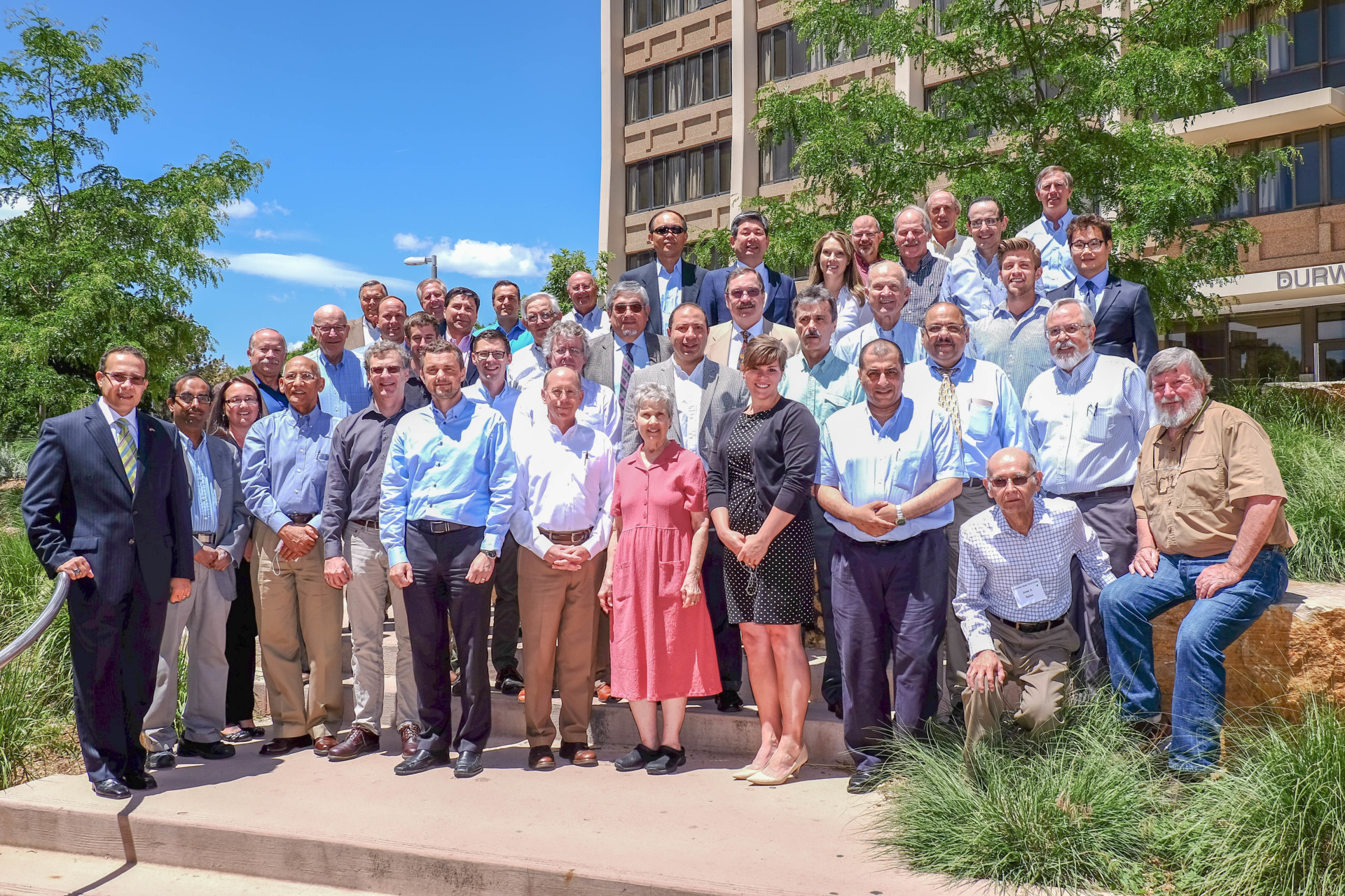


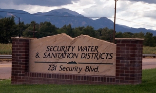


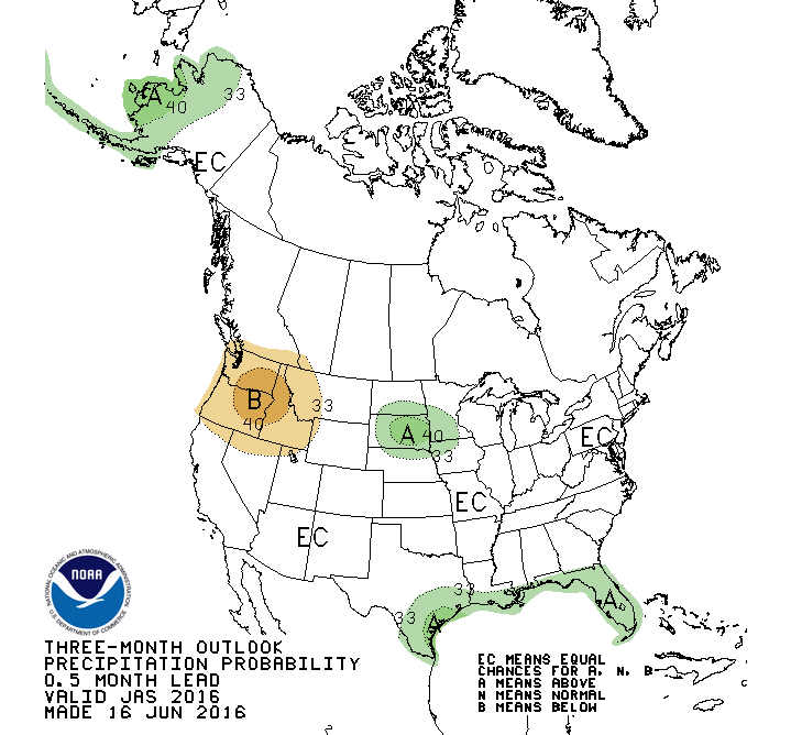


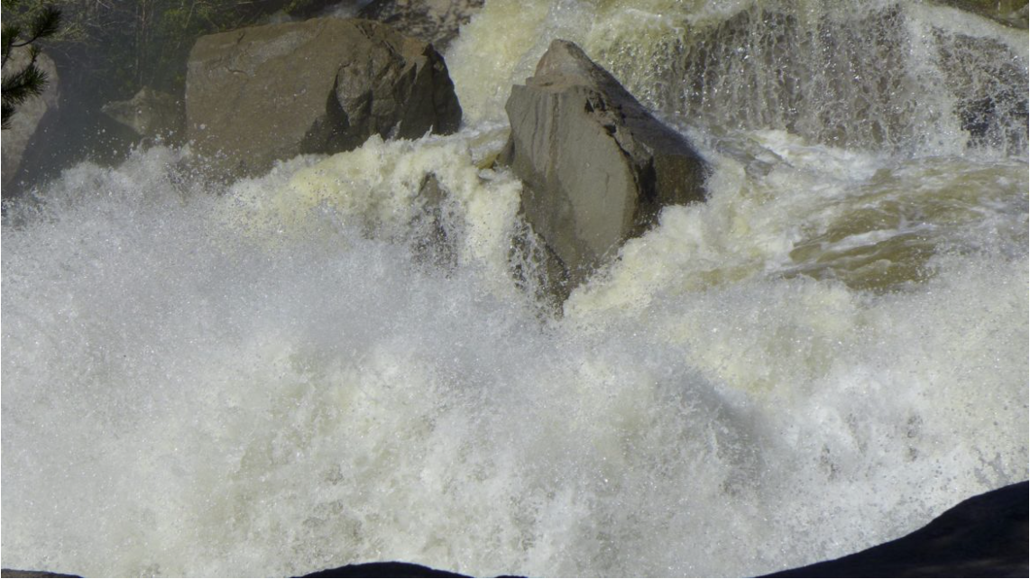


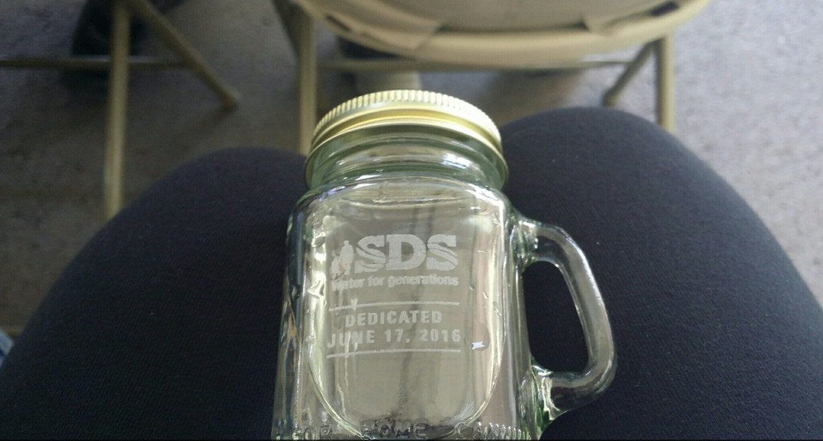


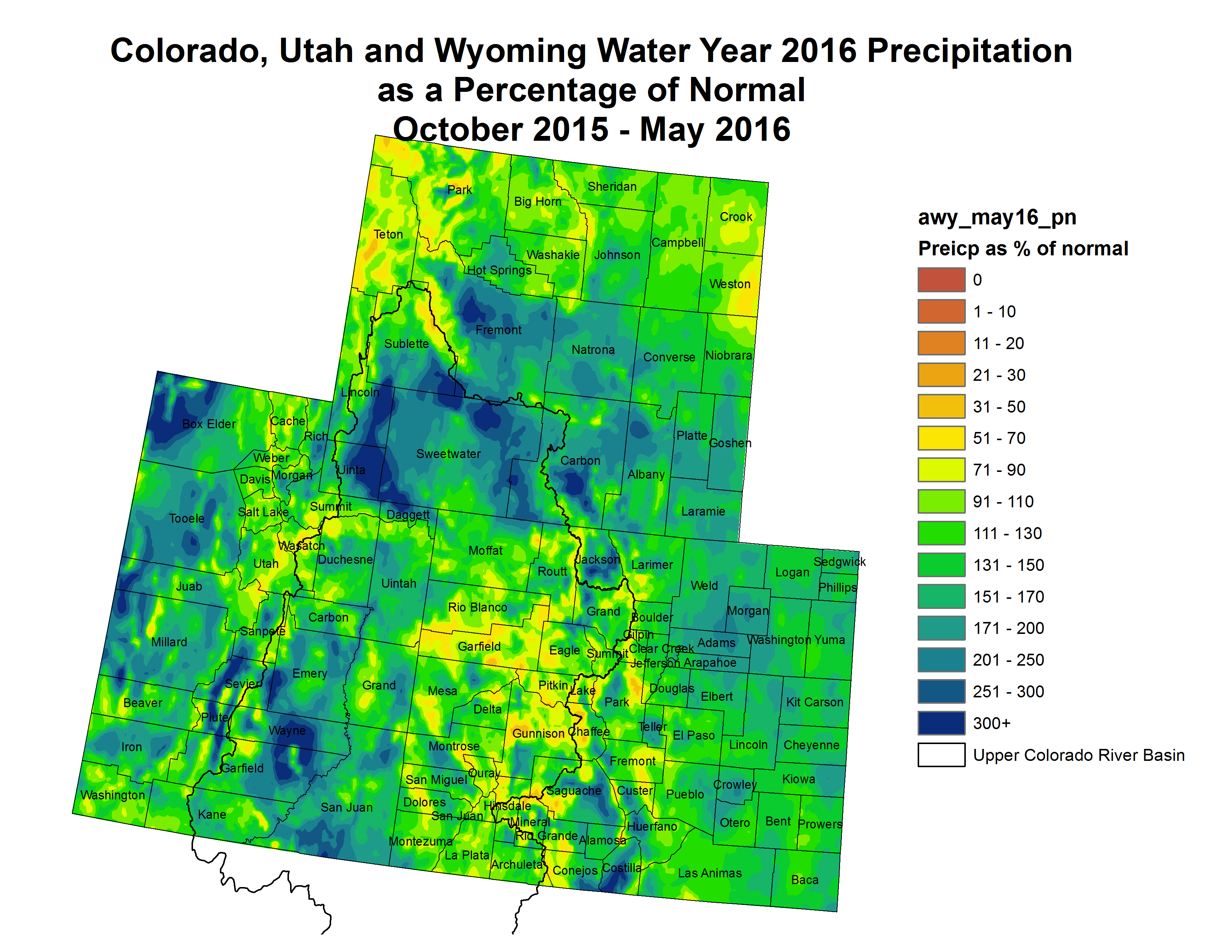


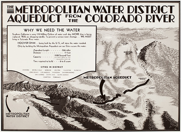


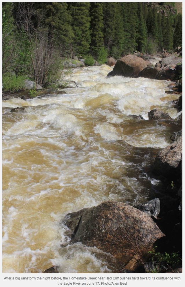
![Caption: Imperial Valley, Salton Sea, CA / ModelRelease: N/A / PropertyRelease: N/A (Newscom TagID: ndxphotos113984) [Photo via Newscom]](https://coyotegulch.blog/wp-content/uploads/2016/06/imperialvalleyfieldssaltonseawikipedia.jpg)