Report: Remediation Scenarios for Attenuating Peak Flows and Reducing Sediment Transport in Fountain Creek, Colorado, 2013
From the Lower Arkansas Valley Water Conservancy District (Norman Kincaide) via The La Junta Tribune-Democrat:
At a work session held Wednesday, May 18, 2016, the Lower Arkansas Valley Water Conservancy District (LAVWCD) board members listened to farmers’ concerns about the possibility of a dam to be built on Fountain Creek. All board members were in attendance except Melissa Esquibel. First on the agenda was Cindy Lair, Colorado Department of Agriculture. Lair reported on salinity and nutrient pollution in the Arkansas River, stating that agricultural users are not big polluters compared to municipalities. Regardless of historically high levels of salinity in the Arkansas it is likely that the salinity issue will have to be addressed in the future. This means that agricultural users will have to address the issue along with municipalities. How and by what means salinity in the Arkansas will be remediated remains to be seen but funding for remediation may come from NRCS or the Colorado Water Quality Control Department. Regardless of the means and funding, Kansas wants to see Colorado users moving in the right direction by 2022.
Following Lair’s report, Alan Frantz of Rocky Ford, gave a short slide presentation: Fountain Creek vs. Individual Water Rights. Slides showed graphs and data on Fountain Creek that from 1921 to 1965 (44 years) that there were 21 flows with less than 10,000 cfs and 10 flows higher with 13 years of data missing. From 1966 to 2014 (48 years) there were 36 flows less than 10,000 cfs and 7 flows higher with 5 years of data missing. This data came from the Fountain Creek Flood Control Study of Oct. 14, 2015. Frantz raised the question of: Is there really a problem? Speaking for ditch directors and shareholders of all the ditches, county commissioners, Ark Valley Ditch Association, well associations and others, they think there is not a problem with Fountain Creek and wanted some questions answered.
These groups want an independent engineering study to evaluate possible consequences of any type of structure on Fountain Creek, (whether it be a dam or holding ponds), an in depth assessment of historical precipitation versus stream flow and assess the validity of Duane Helton’s Fountain River study. Furthermore, a professional analysis and discussion on long term effects of structures on the whole river system was also desired. What was needed from LAVWCD was expertise and technical assistance.
Agricultural users want to form a committee consisting of 5 to 7 individuals, including farmers and ditch directors, a county commissioner or two, with Jack Gobel, District Engineer for LAVWCD, for technical support and funding from LAVWCD for completion of the study. Frantz asked if there are any valid reasons this study should not be pursued.
Farmers are concerned about the amount of press given to a Fountain Creek dam. A Pueblo Chieftain article published Tuesday, May 17, 2016, the opinions of two researchers, Del Nimmo and Scott Hermann, indicated that a dam on Fountain Creek would decrease erosion. Without mentioning the consequences to peak flow users and prior appropriations to agricultural users, Nimmo said: “A large dam could provide better understanding of what’s happening in the watershed, and be a good recreational benefit to the entire watershed of Fountain Creek.” The main reason for supporting a dam on Fountain Creek is to reduce erosion, which is the primary cause for selenium making its way into the water. Scott Hermann said: “A large dam on Fountain Creek would give us the flood control we need, but also provide recreational opportunities that are primary, with a pool of water as well as tailwater. So we have a fishery and fishing benefits from such a structure.”
Here’s the release from the USACE Omaha office (Katie Seefus):
The annual sediment flushing exercise will be completed at Cherry Creek Reservoir, near Aurora, Colorado on Wednesday, June 1, 2016.
Katie Seefus, water manager in the U.S. Army Corps of Engineers’ Omaha District office, says the exercise involves high releases from each of the five main outlet gates at Cherry Creek Dam, located south of Interstate 225 in Aurora. “When the gates are opened, the high velocity of the water leaving the reservoir scours the area immediately upstream of the gates and transports sediment with the flow,” said Seefus. The sediment flush is required to allow proper operation of the outlet gates.
Cherry Creek Dam will begin releasing 50 cubic feet per second (cfs) at 2:30 p.m. on Tuesday, May 31. The actual flushing exercise will begin at 9 a.m. and end at 12 p.m. on Wednesday, June 1 when the release will be set back to normal levels. The travel time from Cherry Creek Dam to the streamgage located at the Champa Street Bridge, is about 6 hours…
Omaha District Commander Col. John Henderson asks the public to be aware that the high flows will take some time to reach the downtown channel, and flows from the last gate opened will not reach the downtown channel until late afternoon on Wednesday. The high flows will cause higher than normal creek stages and potential flooding of bike paths and stream crossings. “In the interest of public safety, I urge the public to not attempt to cross the stream during this event,” says Henderson.
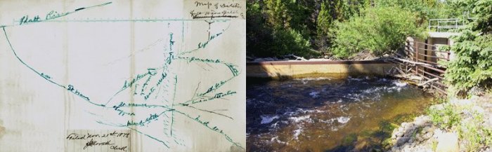
Above, left: This hand drawn map is one of the original documents of Coffin V Left Hand Ditch, at the Colorado State Archives. A few original documents from the Coffin V Left Hand case can be seen at the Colorado State Archives, filed under case #885, #1103 and #1203. Above, right: The headgate of the Left Hand Ditch on the South St. Vrain, where the famous confrontation took place.
People can register to participate in a June 11 Boulder County Parks and Open Space water tour that’s to highlight the 150th anniversary of the Left Hand Ditch Company.
The 7:30 a.m. to 2:30 p.m. tour will begin at the Plaza Convention Center, 1850 Industrial Circle, Longmont, and start with presentations on water law, the orientation of the overall Left Hand basin and the history of the Left Hand Ditch.
Tour buses will then visit stops at sites in the Left Hand Ditch system before returning to the Plaza Center. The water tour, which will include a light breakfast and lunch, will cost $20 per participant.
The 2016 Water Tour is supported by Boulder County Parks and Open Space, Boulder’s Open Space and Mountain Parks, the St. Vrain and Left Hand Water Conservancy District and Left Hand Water District.
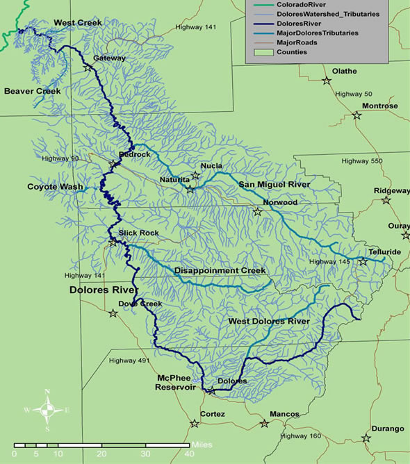
Reservoir managers have announced a 10-day spill at an approximate rate of 1,000 cubic feet per second. However the plan is to begin the release the first weekend of June instead of over Memorial Day as forecasted last week.
“There will be a spill, and by pushing it forward we’re setting up the boaters for a longer season with improved rafting flows,” said Mike Preston, manager for the Dolores Water Conservancy District.
Warmer weather beyond the current five-day forecast could accelerate the start of the spill by a few days.
McPhee will fill and provide full farmer allocations, with an estimated left-over water for rafting.
Cooler, stormy weather and significant snowpack holding in the mountains forced managers to adjust the timing of the spill until the first weekend of June.
Reservoir managers are waiting on a second peak runoff from remaining snowpack.
Preston said the decision for the delay is to avoid the possibility two small spills and their associated ramp-up and ramp-down water needs. For safety, spills are gradually increased 200 cfs at a time, then reversed at the end of the controlled spill.
Releasing rafting flows for Memorial Day weekend was not seen as ideal for boaters because managers would have to stop it to allow the reservoir to fill. Then a second spill would likely be required to avoid overfilling the reservoir as the second peak finishes coming down.
“Delaying for one release saves ramping water to extend the season,” Preston said.
The benefits of a single combined spill of rafting flows allows for longer trips and less down-river congestion of boaters.
The district worked closely with the Dolores River Boating Advocates on the early June release decision.
“There has been definite improvement in communication between the reservoir managers and the boating community,” said DRBA board member Wade Hanson. “DWCD and the Bureau of Reclamation have been on the ball with timely public notice about a release.”
Boaters should be aware of some new changes on the Lower Dolores River.
The usual private land available for a public take-out/put-in at Slickrock is closed.
However, another landowner is negotiating with the DRBA to open public access point on land just downstream of the bridge at Slick Rock near the old store.
Farther down river, the BLM’s Big Gypsum Valley river access remains open.
Boaters should be especially alert this season on the Lower Dolores because it has not been floated for many years.
A large boulder fall has been reported in Ponderosa Gorge upstream of the Dove Creek pump house at mile 17, and debris flows and log jams are a real possibility.
Also expect campsites throughout the 100-mile section to Bedrock to be overgrown.
“It’s exciting to get on the Lower Dolores after all these years,” said Hanson said. “We will be taking a lot of pictures and GPS coordinates of the campsites to inform the public.”
This image was taken during the peak outflow from the Gold King Mine spill at 10:57 a.m. Aug. 5. The waste-rock dump can be seen eroding on the right. Federal investigators placed blame for the blowout squarely on engineering errors made by the Environmental Protection Agency’s-contracted company in a 132-page report released Thursday [October 22, 2015]
New Mexico launched a legal fight against the EPA and owners of a Colorado gold mine Monday, demanding action, contending the Gold King disaster caused catastrophic harm to downriver people, aquatic insects and fish.
“Not only is this an environmental crisis, but it is a crisis in poor governance. … Governments need to be accountable to neighboring communities as well as their own community,” New Mexico Attorney General Hector Balderas said after filing a lawsuit in federal court.
The lawsuit does not specify monetary damages, but state attorneys said New Mexico is entitled to at least $7 million to reimburse communities for emergency expenditures after the disaster and for independent, third-party monitoring of water quality. In addition, the attorneys estimated New Mexico suffered economic harm of $140 million.
It spares Colorado, for now. Balderas said he’s “having a conversation” with Colorado Attorney General Cynthia Coffman and hopes legal issues between the states can be resolved.
EPA officials declined to comment on the lawsuit, but agency officials said the EPA has paid $1.3 million to help New Mexico cover costs related to the disaster. Coffman declined to comment.
The lawsuit contends New Mexico, tribes and Utah suffered catastrophic damage from the EPA-triggered Aug. 5 spill into Animas River headwaters, a “sickly yellow plume of contamination” that flowed out of southwestern Colorado into New Mexico, the Navajo Nation, Utah and eventually Lake Powell atop the Grand Canyon.The spill damaged water that is the lifeblood of downriver communities’ economy and culture with devastating impact, the lawsuit said.
It demands tougher water-quality testing — using “the highest testing standards that the EPA would impose in any other state in the nation” — by someone outside the EPA.
Compensation would go for remediation and to help agricultural and cultural communities that depend on the river for irrigation and drinking water. “They must be properly compensated and there must be appropriate independent monitoring to prevent future dangers to public health and the economy,” the lawsuit said.
New Mexico blames the plugging of the Sunnyside Mine, currently owned by Kinross Corp., as the root cause of the Gold King disaster because this action backed up acidic, metals-laden water, causing water levels to spread to nearby mines, including the Gold King Mine. The lawsuit also targets Environmental Restoration, the EPA’s contractor, involved in work to try to drain the Gold King when workers accidentally caused a blowout.
New Mexico Attorney General Hector Balderas filed the complaint today on behalf of the New Mexico Environment Department in U.S. District Court in Albuquerque.
The EPA has admitted responsibility for the Aug. 5 mine blowout. Employees of an EPA contractor, Environmental Restoration, released millions of gallons of mine waste laced with heavy metals into the Animas and San Juan rivers during a cleanup operation. The plume carried more than 880,000 pounds of toxic metals including lead, cadmium, copper, mercury and zinc through state and tribal lands.
In addition to the EPA, the lawsuit names EPA Administrator Gina McCarthy, Environmental Restoration, Kinross Gold Corp., Kinross Gold USA Inc. and Sunnyside Gold Corp.
New Mexico is demanding the defendants “abate the imminent and substantial threats” from the Sunnyside Mine network and remediate residual contamination from mine releases. The state is also seeking compensation for environmental and economic damages.
The complaint alleges the state is experiencing “enormous economic losses” because of the spill.
“The indelible images of a mustard-hewed toxic plume meandering downstream – into the habitat of several endangered species and superb sport fishing and recreational grounds – will linger long after the visible impacts of the release have vanished,” the complaint states.
The “lingering stigma” will result in reduced economic activity and a decline in taxes, fees and income because of lost tourism, fishing and land use, according to the complaint.
State Environment Secretary Ryan Flynn said the federal Tort claim notice filed this month included an estimate the state has suffered and will suffer $130 million in lost income, taxes, fees and revenues.
In a telephone interview Monday, Flynn said the department tried to work with the EPA to address ongoing concerns — including monitoring heavy metals levels in the river — but were unable to resolve those matters.
“We tried over seven months to pursue a diplomatic path forward,” he said adding the agency has to be accountable for its promises to address the spill and its aftermath.
A press release from the attorney general’s office states New Mexico and the EPA have been unable to “mutually agree” on a monitoring plan that “appropriately protects” state and tribal lands.
“It is inappropriate for the EPA to impose weak testing standards in New Mexico and I am demanding the highest testing standards that the EPA would impose in any other state in the nation to protect the health and well-being of our citizens,” Balderas said in the release.
In a statement emailed to The Daily Times Monday, EPA Region 6 spokesman David Gray said the agency takes responsibility for the cleanup and has been working to reimburse response costs and provide funding for monitoring plans developed by state and tribal governments.
“EPA’s longstanding practice has been not to comment on pending litigation filed by external parties,” Gray said.
He added the EPA has paid approximately $1.3 million in reimbursements and monitoring costs for New Mexico. Other funding has been distributed to Colorado, Utah, the Southern Ute Indian Tribe, the Navajo Nation and the Ute Mountain Ute Tribe.
Louie Diaz, spokesman for Kinross, said in an email Monday that Kinross and Sunnyside Gold were not involved and have no responsibility regarding the mine spill.
The complaint names Kinross Gold Corp., through its subsidiary Kinross Gold USA, as owner of the Sunnyside Mine and neighboring properties near Silverton, Colo.
“Kinross and Sunnyside never owned or operated the Gold King Mine. We will vigorously defend ourselves from this legal action,” Diaz said.
The 51-page complaint asks the federal court to declare the defendants liable under the Comprehensive Environmental Response, Compensation and Liability Act for all costs incurred by New Mexico for its response to the releases or threatened releases of hazardous substances from the Gold King Mine and two additional locations, which are also mine sites in the mountains above Silverton.
The court is being asked to declare the named mining companies and EPA contractor in violation of the “imminent and substantial endangerment” provision in the Resource Conservation and Recovery Act.
The contractor, Environmental Restoration, did not return calls seeking comment today.
In addition, it requests EPA Administrator McCarthy to find a way to moderate pollution from inactive and abandoned mines in Colorado that discharge acid mine waste water into the Animas River.
New Mexico is asking the court to declare the mine owners and EPA contractor “negligent, grossly negligent or both” and award the state compensatory, consequential and punitive damages.
The complaint comes months after the state announced its intent to sue the EPA, the owners of the Gold King and Sunnyside mines, and the state of Colorado, which was not named in Monday’s complaint.
James Hallinan, spokesman for the attorney general’s office, said the state is still attempting to resolve issues with Colorado. Letters obtained by The Daily Times sent by Balderas to the EPA and the Colorado attorney general last week detailed some of the state’s problems with responses to the spill.
Navajo Nation President Russell Begaye said the tribe will support New Mexico in its action and the tribe will closely monitor the lawsuit.
The president added the economic and environmental impacts and losses related to the spill, including abandoned crops, “heavily affect” the tribe, and the EPA has yet to reimburse those Navajo farmers and ranchers.
“The U.S. EPA has yet to provide significant clean-up along the river banks and in the river beds. The Navajo Nation is still very concerned that the contaminants will continue to migrate down river, particularly when there is a spike in the flow of the river,” Begaye said.
The orange plume flows through the Animas across the Colorado/New Mexico state line the afternoon of Aug. 7, 2015. (Photo by Melissa May, San Juan Soil and Conservation District)
From the Associated Press (Susan Montoya Bryan) via The Columbian:
The federal lawsuit says the environmental effects of the August 2015 spill are far worse than claimed by the U.S. Environmental Protection Agency. New Mexico wants to be paid back for its immediate response to the disaster and receive funding for long-term monitoring, lost revenue and a marketing campaign to undo the stigma left behind by the bright-yellow plume of arsenic, lead and other heavy metals that fouled rivers in three Western states.
“The liability is crystal clear. The facts speak for themselves, and EPA for whatever reason is unwilling to resolve this outside of court,” New Mexico Environment Secretary Ryan Flynn told The Associated Press. “We’re going to do what we need to do to make sure New Mexicans are protected and compensated for the harm caused.”
[…]
Balderas said the spill has had a devastating effect on communities and that the federal agency should be held to the same standards it would impose on private interests accused of polluting.
“Remediation and compensation dollars have been far too minimal for these very special agricultural and cultural communities who depend on this precious water source for irrigation and drinking water,” Balderas said. “They must be properly compensated and there must be appropriate independent monitoring to prevent future dangers to public health and the economy.”
The EPA typically declines to comment about pending litigation but a spokeswoman said last week that the agency was taking responsibility for the cleanup…
A notice sent this month to the EPA outlined the damage and argued that heavy metals in the Animas and San Juan rivers remain at levels that “present unacceptable risks to health and the environment.”
Attorneys for New Mexico argue that the spill was preventable and that the EPA had been warned about a potential blowout nearly a year before the incident.
The state also contends its offers to lead a regional long-term monitoring project to better understand the damage and the prospects of future contamination flowing down the river system have been repeatedly rebuffed by the EPA.
The agency offered $2 million to states and tribes affected by the spill for monitoring, but New Mexico officials say that’s only a fraction of the more than $6 million that would be needed for adequate monitoring in the state.
New Mexico also estimates the spill is costing the state $130 million in lost income taxes, fees and revenue. Officials have pointed to reduced tourism, fishing and land use throughout the region.
The state sued the Environmental Protection Agency, contractor Environmental Restoration LLC, and owners of the Gold King Mine as defendants. It’s the first state to take this kind of legal action…
New Mexico officials say that about $130 million would go toward economic damages, $17 million would be spent on a marketing fund to promote the state’s image, and $6 million would be spent on long-term water quality monitoring. About $1 million would help recoup emergency response costs at the time of the spill.
New Mexico isn’t the only state struggling with covering costs associated with the spill. La Plata County, in Colorado, reports a deficit of nearly $185,849 spent on wages, benefits and water quality monitoring since the spill. San Juan County reports that it’s seeking reimbursement for $357,363 for spill-related expenses through Feb. 29, 2016.
Animas River through Durango August 9, 2015 photo credit Grace Hood
In a lawsuit filed Monday in federal court, Attorney General Hector Balderas and the New Mexico Environment Department cite economic setbacks and environmental damage suffered by the state after more than 3 million gallons of toxic waste was dumped into the river.
It demands reimbursement of $889,327 for short-term emergency-response costs paid by the state, more than $6 million to pay for long-term monitoring of the Animas and San Juan rivers and $130 million for lost income, taxes, fees and revenues suffered by the state because of the spill.
“The river only flows one way,” said Ryan Flynn, New Mexico environment secretary. “Trouble could still be coming for New Mexico. We have been pushing for a monitoring effort since October. Our concept is $6 million plus and five years of comprehensive monitoring that would give us a firm grasp of what is happening in the watershed. All EPA has said is we will give you is $465,000. That just doesn’t cut it.”
[…]
Flynn said efforts to resolve issues with the EPA outside of court have proved fruitless.
“I couldn’t tell you what EPA is thinking,” Flynn said. “EPA seems totally unwilling to resolve this in a collaborative manner.”
Among the major impasses between New Mexico and the EPA has been appropriate screening levels for contaminant metals such as lead.
Flynn said the EPA wants to impose a recreational standard that would be safe for hikers and campers, but New Mexico believes the much more strict residential standard should be applied because people live along the affected rivers in New Mexico.
“There are a lot of people whose homes are right on the river or who use the river for a lot more than kayaking,” Flynn said.
Balderas agrees.
“It is inappropriate for the EPA to impose weak testing standards in New Mexico, and I am demanding the highest testing standards that the EPA would impose in any other state in the nation to protect the health and well being of our citizens,” Balderas said. “Additionally, remediation and compensation dollars have been far too minimal for these very special agricultural and cultural communities who depend on this precious water source for irrigation and drinking water. They must be properly compensated, and there must be appropriate independent monitoring to prevent future dangers to public health and economy.”
The EPA does not comment on pending litigation filed by outside parties. But in a statement released Monday, the EPA said the agency takes responsibility for the mine spill cleanup and has been working to reimburse response costs and fund tribal and state monitoring plans as well as conduct its own monitoring of the Animas and San Juan rivers.
“EPA has funded about $1.3 million in reimbursements and monitoring cost for New Mexico to date,” the EPA statement said. “We continue to review documentation and applications for different entities in the state and will expedite payments. New Mexico has $7.1 million available in unallocated federal funds – of which $108,000 has already been approved – to fund real-time monitors in the river.”
[…]
Flynn said the EPA has paid back more than $700,000 of the emergency-response money New Mexico shelled out dealing with the spill, but that the state is seeking another $800,000-plus from the federal agency to cover those costs.
New Mexico also wants $130 million to pay for economic losses it attributes to the mine spill.
“We asked our analyst to be as conservative as possible,” Flynn said. “But there is stigma associated with this region due to the yellow river.”
He said that stigma had hurt New Mexico in revenue lost because kayakers, fishermen, hikers and other outdoorsmen have sought other places to enjoy outdoor recreation, tourists have selected other vacation destinations and consumers of agricultural products have looked elsewhere for their purchases.
“The facts speak for themselves,” Flynn said. “They (EPA) are clearly at fault. At the end of the day the law is on our side. EPA is now on the other side of the law it has been fighting to enforce for so many years.”
Cement Creek aerial photo — Jonathan Thompson via Twitter
The lawsuit, filed in U.S. District Court in New Mexico, names the EPA and its administrator, Gina McCarthy, Environmental Restoration, LLC, Kinross Gold Corp., Kinross Gold U.S.A. Inc., and Sunnyside Gold Corp. as defendants. Kinross is the parent company of Sunnyside.
Along with seeking compensation for environmental and economic damages related to the Aug. 5, 2015, Gold King Mine spill, the lawsuit “demands that the Defendants abate the imminent and substantial threats emanating from the mines in Colorado, and remediate residual contamination from the Gold King Mine releases in New Mexico’s surface waters and sediments.”
James Hallinan, communications director for the New Mexico Office of the Attorney General, said he could not comment on open litigation, but the New Mexico Attorney General’s Office is in “ongoing communication” with the state of Colorado over the Gold King spill. The state of Colorado and the owner of the Gold King Mine were not named in the lawsuit filed Monday, although in March the New Mexico Environment Department filed notice of its intent to sue those parties as well.
Colorado Attorney General Office spokeswoman Erin Lamb declined to comment on the lawsuit.
A spokesman with Kinross Gold Corp. responded in an email to a request for comment: “Kinross Gold and Sunnyside Gold were not involved and have no responsibility regarding the incident on August 5th, 2015 and Kinross and Sunnyside never owned or operated the Gold King Mine. We will vigorously defend ourselves from this legal action.”
The lawsuit claims the “root cause” of the disaster dates back more than 20 years to Sunnyside Gold’s attempt to block acid mine drainage by building bulkheads in drainage tunnels below the mine. The owners of the Gold King and Sunnyside mines have disputed the source of the wastewater buildup.
“These bulkheads impounded possibly billions of gallons of acid mine drainage and wastewater in Bonita Peak Mountain and caused the water to flood several adjacent mines,” the complaint says. It accuses Sunnyside Gold of using the mountain to store its waste rather than properly treating it.
General view of the Sunnyside Mine, southwestern Colorado photo via the Denver Public Library
A federal grant will fund an economic development coordinator to help Silverton and San Juan County businesses during the potential Superfund cleanup of historic mines.
“They are totally reliant on tourism, and we don’t know how that will be impacted,” said Laura Lewis Marchino, the deputy director of the Region 9 Economic Development District.
The U.S. Economic Development Administration is providing about $115,600 to pay a coordinator for two years and cover expenses such as marketing materials and travel, Marchino said.
The coordinator will be focused on supporting existing businesses through the federal cleanup of the Bonita Peak Mining District, which could include 48 mine-related sites.
The mining district was recommended for a Superfund listing in April following the Aug. 5 mine blowout, and the proposed designation is nearing the end of a 60-day comment period.
Easing the housing shortage when Superfund workers come to town will likely be another priority for the coordinator, she said.
During the construction of the temporary water-treatment plant near the Gold King Mine, there was not enough housing, she said.
The town needs more rentals so that hotel and motel rooms aren’t used as permanent housing.
The five-member San Juan Development Association Board that includes representatives from the town of Silverton, San Juan County, the Silverton Chamber of Commerce and Region 9 will hire the new coordinator.
Region 9 will manage the two-year grant, and Marchino would like to have the position filled by late summer.
“We needed to do what we could to help,” she said.
Silverton, Colo., lies an at elevation of 9,300 feet in San Juan County, and the Gold King Mine is more than 1,000 feet higher in the valley at the left side of the photo. Photo/Allen Best
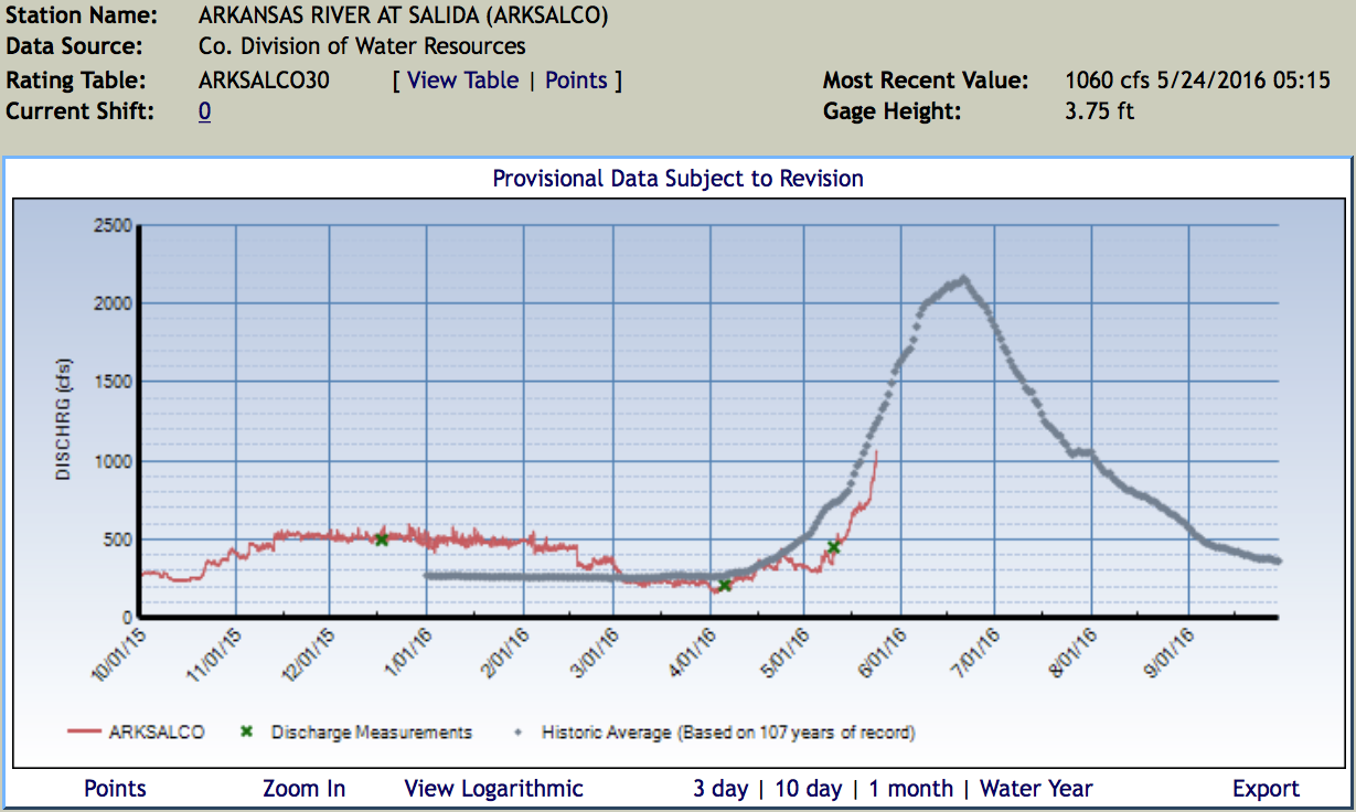
Spring snowmelt is already bringing fast-moving and rising water to the Arkansas River in Pueblo, according to the local Swift Water Rescue Team, and kayakers and fishermen alike are being urged to take caution.
The U.S. Geological Survey showed the Arkansas River spiking by 600 cubic feet per second on Monday through Pueblo, deepening one stretch by a whole foot. The river at the Moffat Street gauge was running at 1,440 cfs on Wednesday afternoon, making water in the city kayak course in particular a challenge, according to KOAA Channel 5.
“The kayak course … was designed for people who are used to kayaking or boating, who know what they’re doing and have more river experience,” Pueblo Fired Department engineer Ryan Moran told the news outlet. “This is not a place for just inner-tubing leisurely.”
Denver Water says, so far this year, their water supply is in good shape thanks to above-average snowpack levels in the local collection areas, nearly full reservoirs and continued efficient water use by consumers.
But what will it look like as the state heads into the hot, summer months?
Water conservation is not only needed in dry years. Colorado is a dry area, and water is finite. It’s vital for those who live in the state to conserve water in order for Colorado’s economy to thrive. Farmers and ranchers across the state rely on higher water levels. Wildlife and aquatic life in local rivers and streams need enough to live off of. Those who enjoy the recreational activities in the state want higher river and reservoir levels.
No matter what the conditions may be, Coloradans must use water efficiently. Denver Water has annual summer watering rules in place from May 1 until Oct. 1. The rules should reinforce best practices to help customers use water properly and when needed while still keeping landscapes healthy.
The biggest mistakes people make is with their irrigation controller settings. Sprinkler systems are not meant to be forgotten once they are set. It’s important that consumers adjust their settings depending upon the month and recent rainfall. That means, if it rains, and your system doesn’t have a rain sensor, turn off your irrigation system until your landscape needs water again.
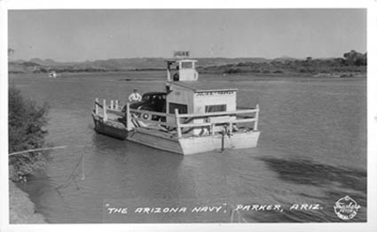
The last time two states went to war over water, it was 1934. The combatants were California and Arizona and the casus belli was the start of construction of Parker Dam, which would direct water from the Colorado River into California via the Colorado River Aqueduct.
The episode unfolded with a sort of Gilbert and Sullivan absurdity. Arizona’s governor, Benjamin Baker Moeur, dispatched a handful of National Guardsmen upriver in a ferryboat named the Julia B., which frontline correspondents dispatched to the river by The Times and other California newspapers happily dubbed the “Arizona Navy.” The “brave little Julia B.,” The Times reported, promptly ran into a sand bank and got worked free by bridge-building crews, after which a truce was dictated by the federal government.
The next water war may involve the same combatants, but may not be so amusing. Lake Mead, the main reservoir holding Colorado River water for California, Arizona and Nevada, has reached its lowest point since it began filling behind Hoover Dam in 1935. As of midnight Sunday, the lake reached 1,074.37 feet above sea level. It’s expected to keep falling until mid-summer, reaching 1,070 feet before seasonal agricultural demand falls off and it begins to fill again. Last year, the reservoir reached a low point of about 1,075 feet, but not until late June.
Herbert Hoover presides over the signing of the Colorado River Compact in November 1922. (Courtesy U.S. Department of Interior, Bureau of Reclamation)
The long-term prospects for Colorado River supply are dire. Demand for its water among the seven states of the river basin–chiefly California and Arizona–hopelessly outstrips the supply, and has been almost since the seven states in its basin worked out an allocation deal in 1922. That interstate compact, brokered by then-Commerce Secretary Herbert Hoover, was based on an estimate of river flows that was flagrantly inflated and never has been met. Since then, the recognition of claims from Mexico and Southwestern Indian tribes has only increased demand. Climate change and drought are making the crisis worse.
So water officials from California, Arizona and Nevada have been meeting to work out a solution. Arizona faces the most pressing deadline: Under existing agreements, if the current Lake Mead level persists to the end of this year, the Central Arizona Project, which supplies Colorado River water to Phoenix and Tucson, will be required to give up roughly 13% of its allocation. Further cutbacks are mandated if the lake falls to 1,050 and 1,025 feet, at which point Arizona would lose 17% of its water. Each cutback would especially threaten the livelihood of farmers dependent on the Central Arizona project, who have the most junior rights to the water.
Nevada would also face cuts, though these would be relatively modest, since the state has the smallest allocation from the river.
The interstate talks are focused on maintaining the level of Lake Mead to avert a federal declaration of shortage triggering the Arizona and Nevada cutbacks. The idea on the table involves California’s taking a voluntary reduction of as much as 8% of its annual allocation of 4.4 million acre feet from the river if the level gets much lower. That would be an extraordinary concession, since existing interstate and federal agreements largely exempt California from any cutbacks as long as there’s water in Lake Mead to meet its allocation. The chief consequences for California of a continued decline in Lake Mead’s water level is that the date of a required renegotiation of water allocations, now set at 2026, would be accelerated by several years. (One acre-foot equals about 326,000 gallons, enough to serve one or two average California households.)
But California officials know that working out an interstate deal to keep the reservoir level higher is the wiser option in the long run. “At the end of the day,” says Jeffrey Kightlinger, general manager of Southern California’s Metropolitan Water District, “once you get so low, California loses out.”
Among the risks is that federal officials could step in to impose a reallocation settlement among the three states. Arizona’s U.S. senators, John McCain and Jeff Flake, already have hinted at trying to work a settlement agreement into federal legislation, a step that would probably provoke a donnybrook among the two states’ congressional delegations without resolving the underlying issues.
“If you ask Congress to solve your problems,” Kightlinger says, “you’re usually asking for trouble.”
Nor does anyone want the issue to land in court; the last major lawsuit over river water, the 1952-vintage Arizona vs. California, would last 11 years and go down in history as one of the longest, costliest and most complicated ever to come before the Supreme Court. Its outcome pleased neither party, for the justices ruled that federal officials, not the states, had the ultimate say on the river — “the life-and-death power of dispensation of water rights long administered according to state law,” complained Justice William O. Douglas in a furious dissent.
All the parties are under pressure to reach an agreement by the end of this year, before the current administration leaves office and the process has to start anew with new federal overseers. But the interstate complexities may pale in comparison with the difficulty of working out agreements among water users within each state. California’s Imperial Irrigation District, which has the largest entitlement of Colorado River water, has balked at any agreement to preserve water levels in Lake Mead without a parallel agreement to preserve the Salton Sea. That huge inland pond has suffered as a result of earlier multi-billion-dollar deals by which the Imperial Irrigation District transferred water to San Diego, the MWD and other users.
The shrinkage of the sea already is an environmental and public health disaster. Withholding more water in Lake Mead without a rescue plan would be unacceptable, Imperial Irrigation District General Manager Kevin Kelley said recently. “The Salton Sea has always been the elephant in the room in these talks,” he told the Desert Sun newspaper.
The real elephant in the room, however, is the prospect of a lasting shortage in Colorado River water supply. Says Kightlinger, “It’s no longer a matter of if, but when.”
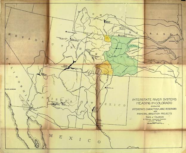
Delph Carpenter’s 1922 Colorado River Basin map with Lake Mead and Lake Powell


![This image was taken during the peak outflow from the Gold King Mine spill at 10:57 a.m. Aug. 5. The waste-rock dump can be seen eroding on the right. Federal investigators placed blame for the blowout squarely on engineering errors made by the Environmental Protection Agency’s-contracted company in a 132-page report released Thursday [October 22, 2015]](https://coyotegulch.blog/wp-content/uploads/2015/10/goldkingminespill1057am08052015viaepa.png)