“Corn are thirsty and dying, damn the EPA, damn the government, damn the industry!”
— Duane “Chili” Yazzie, Navajo farmer, activist and President of the Shiprock Chapter, from his poem “Yellow River”
On May 23, the State of New Mexico filed a lawsuit against the U.S. Environmental Protection Agency and the owners of the Sunnyside Mine near Silverton, Colorado, over damages caused by last year’s Gold King mine blowout. It’s likely just the first volley in what could be a long legal fracas emerging from both the spill and the impending Superfund listing for the Gold King and surrounding mines.
The action was hardly a surprise: New Mexico had expressed its intention to take legal action when the impacted rivers — the Animas and the San Juan — were still orange from the spill of 3 million gallons of acid mine drainage and iron oxide sludge. Initially, however, the state was targeting not just the EPA, but also the State of Colorado, the owner of the Gold King Mine and others. The only defendants in the actual complaint are: the EPA and its administrator Gina McCarthy; the contractor working on the mine when it blew out; and Sunnyside owner Kinross, a Canada-based global mining company, and its subsidiary Sunnyside Gold Corp.
Animas River through Durango August 9, 2015 photo credit Grace Hood
While the EPA has accepted blame for inadvertently causing the spill, Sunnyside’s culpability in the matter is murky. After being almost dry for years, the Gold King mine started draining water in the late 1990s or early 2000s, most likely a result of water backing up behind one or more of the three bulkheads that Sunnyside installed in the American Tunnel, below the Gold King. Yet still unknown is which bulkhead, in particular, is causing the drainage, and whether Gold King water is just being returned to its historic course, or Sunnyside mine water is somehow infiltrating the Gold King. (See our extensive, interactive timeline, which clearly helped inform the New Mexico complaint, for details.)
The complaint alleges that the “garish yellow cloud of contamination wrought environmental and economic damage throughout the Animas and San Juan Rivers” and that it deposited sediment that could be re-mobilized during spring runoff, causing a potential repeat. Perhaps more damaging than the metals contained in the plume and sediment was the psychological impact, and the “uncertainty and anxiety generated by widely-circulated images of a sickly yellow river.” The state seeks reimbursement of all of its costs related to the spill, which it says exceed $100 million.
At a recent regional water quality conference in Farmington, New Mexico, one speaker noted that the “river would never be the same” after the spill. Yet water sampling and fish counts conducted since the spill have shown that things haven’t changed significantly. At the conference, a presentation by Jim White, aquatic biologist with Colorado Parks and Wildlife, noted that fish counts showed “no discernible changes in species composition, biomass, and/or quality of trout or native fishes POST Gold King Mine spill.” And an analysis conducted by the Mountain Studies Institute in Durango this spring showed that metal concentrations in the Animas River have increased during spring runoff, but not noticeably more than in past years.
On April 7, the Environmental Protection Agency proposed adding the “Bonita Peak Mining District” to the National Priorities List, making it eligible for Superfund. Forty-eight mine portals and tailings piles are “under consideration” to be included. The Gold King Mine will almost certainly be on the final list, as will the nearby American Tunnel. The Mayflower Mill #4 tailings repository, just outside Silverton, is another likely candidate, given that it appears to be leaching large quantities of metals into the Animas River. What Superfund will entail for the area beyond that, and when the actual cleanup will begin, remains unclear. Eric Baker
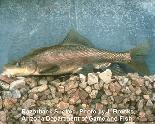
Spring snowmelt runoff in the Colorado Rocky Mountains has triggered the spawning and emergence of endangered razorback sucker fish populations in the Green River downstream from Flaming Gorge Dam, Utah. Larval emergence in the river was observed on May 28, 2016.
To assist the survival of this endangered fish population, Bureau of Reclamation officials will gradually increase water released from Flaming Gorge Dam from the current flow of 800 cubic feet per second (cfs) to 8,600 cfs beginning Tuesday, May 31, 2016. The rate of release will reach 8,600 cfs on Friday, June 3, 2016, and will remain at that flow rate until further notice. However, Reclamation officials anticipate the release to remain at this rate for only 7 to 14 days beyond June 3.
At the highest rate, Flaming Gorge reservoir will release approximately 4,600 cfs through the Flaming Gorge Dam powerplant, allowing power generation to reach its full capacity of approximately 150 megawatts. Another 4,000 cfs will be released through the dam’s bypass tubes to reach the total of 8,600 cfs.
Projected peak flow on the Green River at Jensen, Utah, resulting from the combined flows of Flaming Gorge Dam releases and the Yampa River, will be approximately 22,000 to 24,000 cubic feet per second. These projections are close to flood stage and Reclamation officials urge caution while recreating or farming along the Green River during the next few weeks.
Scientists monitor critical habitat to detect the first emergence of razorback sucker larvae as a “trigger” for this type of release by Reclamation in cooperation with the State of Utah Division of Wildlife Resources, U.S. Fish and Wildlife Service and the Upper Colorado River Endangered Fish Recovery Program. A major purpose of the higher release is to transport as many larval fish as possible into critical nursery habitats located in the floodplains along the Green River, downstream of the confluence of the Green and Yampa rivers. The increased releases from the dam, combined with the Yampa River flows, will provide the maximum possible flow of water to transport the larval fish.
Reclamation consulted with the Utah Division of Wildlife Resources concerning possible impacts of the releases to the rainbow trout fishery below the dam. While releases during this period will make fishing the river more difficult, no adverse impacts to the fishery are expected.
Meanwhile, Granby Reservoir should fill and spill this year. Here’s a report from Lance Maggart writing for the Sky-Hi Daily News:
Things look to be shaping up nicely in terms of water levels for 2016. The Colorado River District recently hosted a “Grand County State of the River” meeting at Mountain Parks Electric in Granby. During the meeting representatives from the Federal Bureau of Reclamation informed attendees their prediction models indicate Granby Reservoir will physically fill again this year, sometime around the second week of July at which point those administering the water flows will begin bypassing additional water downstream.
Officials expect the massive reservoir to spill slightly, around 1,700 acre-feet of water, right at maximum flow times. Bureau of Reclamation representatives said that if Granby does spill they anticipate moving the excess water through the outlet works for the reservoir’s dam.
So far 2016 has been a fairly average year in terms of precipitation. Reservoirs along the eastern slope of the continental divide are mostly full and transmountain diversions will likely be diminished because of storage levels in places like Horsetooth and Carter Lake Reservoirs.
Willow Creek Reservoir, a relatively small reservoir located just a few miles directly west of Granby Reservoir has seen high levels of runoff already and officials anticipate pumping roughly 40,000 acre-feet of water from Willow Creek into Granby Reservoir this summer. Because of storage limits water from Willow Creek Reservoir is already being bypassed downstream.
Because of the high water levels anticipated for Willow Creek Reservoir and the rest of the Three Lakes Colorado River Collection System officials do not expect to pump any water up from the Windy Gap Reservoir, located west of Granby on US Highway 40 and downstream from Granby Reservoir.
Existing directives from the US Secretary of the Interior require at least 75 cubic feet per second (cfs) of water be released from Granby Reservoir throughout the summer. The Bureau of Reclamation will maintain releases of 75 cfs from Granby Reservoir through October this year as part of the ongoing Upper Colorado River Endangered Fish Recovery Program.
A section of the lower Crystal River in late summer 2012. Irrigators and other water users in the Crystal River valley are working toward ways to leave water in the river during moderate droughts.
CARBONDALE — In an effort to leave more water in the lower Crystal River in dry years, a growing number of irrigators in the watershed are considering entering into non-diversion agreements and are reviewing ways to deliver water to their crops more efficiently.
The agreements would be a product of discussions surrounding the recently released Crystal River Management Plan, which sets a goal of adding 10 to 25 cubic feet per second of water into the river during moderate and severe drought years.
The additional water could come from paying irrigators to reduce their diversions by 5 to 18 percent, depending on conditions, and by helping irrigators improve irrigation ditches and installing sprinkler systems.
The plan also calls on the town of Carbondale to fix the leaky irrigation ditches it uses to move water from the Crystal River through town and for the town to find ways to get its customers to use less raw water in dry years.
And apparently there is progress quietly being made on the plan’s recommendations.
“We’re really hopeful about this approach and it has had a pretty good response from the folks that we’ve had the opportunity to speak about it with in the agricultural community,” said Seth Mason, the principal hydrologist at Lotic Hydrological in Carbondale, who was the primary consultant on the river management plan.
The plan also cites the potential benefits of a 3,000-acre-foot reservoir at the confluence of Yank Creek and North Thompson Creek, although it notes such a reservoir would cost $9.75 million and it’s not clear who would pay for it.
Today there are 25 water diversions on the main stem and tributaries of the Crystal River and together they can pull up to 433 cfs of water from the river system.
In really dry years, the diversions can leave a section of the lower Crystal disturbingly dry, even if the water is being used to keep fields near Carbondale refreshingly green.
Just how many ranchers and farmers in the Crystal River Valley are now actively weighing their water options is uncertain, as the process to develop the river management plan in concert with local irrigators has largely been conducted in private.
But the acknowledgement section of the Crystal River Management Plan released Thursday does list 12 irrigation ditches among the organizations that “informed and advised” the team that developed the new river management plan.
“A long list of individuals and organizations informed and advised the Project Team throughout the planning process,” the plan states, including “Crystal River water rights holders and agricultural producers, including representatives from the Sweet Jessup Canal, East Mesa Ditch, Lowline Ditch, Ella Ditch, Helms Ditch, Pioneer Ditch, Bowles and Holland Ditch, Rockford Ditch, Carbondale Ditch, Weaver and Leonhardy Ditch, Kaiser and Sievers Ditch, and Southard and Cavanaugh Ditch … ”
No names of any individual ranchers, farmers or ditch company shareholders are included in the plan, but the ditches that are acknowledged account for the majority of diversions from the lower Crystal.
Bill McKee, a rancher and irrigator on the Crystal, has been actively involved in talking with local ranchers about the river management plan and he voiced his support for the plan’s recommendations at Thursday’s public presentation at the Carbondale library meeting room.
“In all our discussions, it’s seen as a good time to strike while the iron is hot,” McKee said.
A slide from Lotic Hydrological as presented to the Colorado River District on May 23, 2016. The slide summarizes key points in the new Crystal River Management Plan.
Drought sparked plan
The planning process for the Crystal River Management Plan started after the drought of 2012 left a section of the Crystal River between Thompson Creek and the state’s fish hatchery, just upvalley of Carbondale proper, with only 1 cubic foot per second of water flowing in it below several diversion structures. That year represented at least a one-in-20-year drought.
(On Saturday, May 28 at 10 a.m. the Crystal was flowing at 851 cfs near the fish hatchery).
“It is a fairly large river channel,” Mason said Thursday. “You can imagine that a channel that size is a pretty astounding sight when there is no water in it.”
During 2012 staffers at the Roaring Fork Conservancy and Colorado Water Trust began talking with ranchers about ways to leave more water in the river.
The Trust eventually reached short-term agreements with seven irrigators to leave water in the river in 2013, which was shaping up to be another drought year. Late-season rains negated the need for the agreements, but the work of the Trust helped provide a foundation for ongoing discussions that shaped the current plan.
The Conservancy then contracted with Mason to develop a technical study of the Crystal River and eventually brought in CDR Associates of Boulder to work with stakeholders. Public Counsel of the Rockies, an Aspen-based nonprofit, also joined the planning process and helped raise funds to pay for the plan.
The process has taken two-and-a-half years and cost over $300,000, said Rick Lofaro, the executive director of Roaring Fork Conservancy.
Before the plan was unveiled Thursday it was vetted by some irrigators, a number of whom are now in active discussions with the Colorado Water Trust about non-diversion agreements, according to Mason.
“There are ongoing conversations that I can’t say too much about,” said Mason, who was able to characterize the conversations both among irrigators and the town as “positive.”
A non-diversion agreement is a tool the Water Trust uses to give irrigators and other water users the option to leave water in rivers under certain conditions and terms, without going through a water court process to change an existing water right.
“Such agreements, which used to present risk to water users under Colorado water law, are now protected by [state] Sen. Gail Schwartz’s bill that passed in the 2013 legislative session, Senate Bill 19,” said Amy Beatie, executive director of the Water Trust.
(Please see a related story, “City considers 10-year agreement to leave more water in the Roaring Fork.”)
A slide from a recent presentation by Lotic Hydrological to the Colorado basin roundtable. The graphic illustrates the drying up of the Crystal in 2012 and four threshold questions posed by stakeholders during a recent river management planning process.
Private process
Mason helped clarify the situation for many local ranchers with a graphic that illustrates extremely low flows on the lower Crystal in late summer of 2012 in relation to various irrigation ditches.
He also developed a detailed scientific study of the Crystal River watershed and a model that could show what would happen in the river under various scenarios.
During the planning process, it became clear to Mason and other project team members that many local ranchers were not comfortable attending public meetings that included a bevy of professionals from various organizations.
“We did have other folks in the room at a couple points and that did not go the way we wanted it to,” Mason said. “We had some negative reactions to that and we’re very protective of the process. We wanted to make sure that the agricultural community knew that this process wasn’t a process run by folks who didn’t care about their livelihoods or their importance to the local community.”
The project team also learned that there were some threshold questions that needed to be answered.
One question was whether the periodic lack of water in the Crystal was really “the largest constraint on the ecological function,” as Mason put it.
By studying many different aspects of the river, including sediment flows, Mason concluded that yes, having enough water in the lower Crystal River is a key factor in its ecological health.
Another important question posed by stakeholders was, “How much water is enough to make a difference?”
In answering that question, Mason found that using the state’s instream flow right of 100 cfs in summer on the Crystal below Avalanche Creek as a planning goal was unacceptable to local ranchers.
“The agriculture community was not interested in talking about the state’s instream flow as the benchmark for ecosystem health,” Mason said.
He explained that the 100 cfs figure, which the state adopted in 1975 as the amount of water needed to protect the environment of the Crystal “to a reasonable degree,” was tied to average conditions, not drought conditions, and was therefore unlikely to be met in a really dry year.
What was acceptable to water users was working toward a “moderate,” but not “optimal,” level of flow between between Thompson Creek and the fish hatchery during one-in-five-year and one-in-ten-year droughts.
They also, notably, did not set a goal of reaching moderate flows in a one-in-20-year drought, such as 2012.
Mason concluded that during a severe one-in-10-year drought, an “optimal” flow level in the targeted stretch of river was 55 cfs, and a “moderate” flow level was 44 to 55 cfs.
During a one-in-five-year drought, he found the optimal flow level was 58 and moderate flow level ranged from 46 to 51 cfs.
To fill the expected gap between low river levels and the targeted moderate flow levels, the plan calls for 25 cfs to be left in the river from non-diversion agreements in a 1-in-10-year drought, and for 10 to 15 cfs to be left in the river in a one-in-five-year drought.
The plan states that stakeholders “indicated tolerance for moderate ecosystem risk under average to moderate drought conditions.”
A slide from Lotic Hydrological that illustrates the targeted flow rates for dealing with moderate and severe droughts on the lower Crystal River.
Range of options
After developing a solid scientific foundation and a model to help answer “what if” questions, Mason then developed options for each major irrigator on the Crystal.
These ditch-by-ditch options are not included in the plan, but Mason has been working with willing irrigators to help them understand how a non-diversion agreement might work for them, especially if they are joined by other water users.
The plan also calls on the town of Carbondale to take steps to reduce its diversions from the river, along with the agricultural community.
“Carbondale does have a few big ditches that move quite a bit of water from the river,” Mason said. “That water supports all the lovely large trees that we see down here that wouldn’t be here normally.”
Those steps include lining more of the town’s irrigation ditches to prevent leaking of water and using market forces to curtail use of raw water in dry years.
The new Crystal River Management Plan could be a potential model that could be used to develop other stream management plans, as the state’s recently released Colorado Water Plans calls for such plans on 80 percent of the state’s rivers.
James Eklund, the director of the Colorado Water Conservation Board, which produced the state water plan, complimented the planning process in the Crystal River valley.
“Our quick read says that this plan is based on sound science, examined viable alternatives, and engaged many stakeholders,” Eklund said Friday when asked for comment. “Continued collaboration with water users is required in order to implement effective solutions, but the Crystal River is headed in the right direction.”
Editor’s note: Aspen Journalism, the Aspen Daily News and Coyote Gulch are collaborating on coverage of rivers and water. The Daily News published this story on Sunday, May 29, 2016.
Pitkin County agreed to an intergovernmental agreement last week with the city of Aspen to expedite a study that aims to assess the health of the Roaring Fork River from its origin high atop Independence Pass down to where it meets Maroon Creek.
The $200,000 Upper Roaring Fork River management plan will be funded evenly by the two entities, and address feasible changes to improve the river ecosystem’s health including return flows to keep water levels up. The project will last roughly 15 months, ending in July 2017.
The project will focus on the river’s health; assess the community’s values and expectations; and look into river management objectives during periods of critical flow, a county memo noted. The goal of the study is to improve water quality, recreational opportunities, riparian habitat, and the overall health of the river and surrounding ecosystem.
John Ely, county attorney, said the study will look at water rights and development potential to “assess the ability to coordinate the competing interests to improve or enhance the health of the upper Roaring Fork.”
The study will cover river health from Independence Lake to just below Maroon Creek.
Ely said the county’s $100,000 will be contributed from both the Open Space and Trails and Healthy Rivers and Streams funds. Both of those entities’ boards are supportive of the project and related costs.
April Long, stormwater manager for the city and project manager for the endeavor, told the commissioners that a goal is to determine “realistic view of river health” for the community.
“The health of this section of the Roaring Fork has been on the city’s mind for quite a while now,” she said. “We’ve developed a pretty substantial stormwater management program to improve the runoff from the city areas and from private development before it gets into the river.”
Long added that other issues the river faces include degraded riparian areas and the lack of water during critical times of the year.
“In drought years, like we saw in 2002 and 2012, this section of the river can almost run dry,” she said. “It runs dry enough for you to walk across it without getting your feet wet. That has significant impacts for our aquatic life.”
Long added that the project will have benefits to the entire area, and not just within the city of Aspen. She said stakeholder opinions will be sought to determine what constitutes a healthy river.
Carbondale-based Lotic Hydrological, which recently completed a management plan on the Crystal River, has been hired as consultant for the project.
Long added that all prior river data will be utilized in the study.
“This isn’t a restudy of what is a healthy river, this is using all of the information that comes from different consultants [and county studies],” she said. “Given that everybody thinks there’s these different pieces that make a healthy river, what is actually realistic? What can we make change on? … We want the community to understand that these are the opportunities for a healthy river.”
Commissioner George Newman noted that the county doesn’t want to simply match the current state minimum standards for a healthy river.
“They’re probably woefully [inept] and not going to really address our vision in terms of what makes up or determines a healthy river or stream,” he said.
Long said that while the state’s minimum standards are not viewed as being too low, the community may have higher standards.
“It may be that our community believes we should be striving for more,” she said. “This would actually look at not just striving for more, but what can we actually get done. We may not even be able to meet the minimum in-stream flow at times, therefore what should we be striving for if we can’t get even to that? What is realistic that we can get to?”
The commissioners unanimously approved the emergency ordinance, 3-0.
“For a variety of different events beyond anybody’s control, we were kind of behind the eight ball in getting the project up and running,” Ely said of the ordinance. “If we were to wait and put this on a normal schedule, we’d be further behind.”
He added that even though the terms of the IGA haven’t yet been finalized, it was best to act now.
“At least we have immediate expression of commitment to the project,” Ely said.
The IGA will return before the BOCC for a public hearing on June 22.
Projects to clean up Fountain Creek will resume this fall, after danger of flooding has subsided.
At least two projects are anticipated. One would remove debris from the channel between Eighth Street and Colorado 47, while the other would reconstruct the access road and embankment on a side detention pond behind the North Side Walmart.
“Getting debris out of the channel is the first priority,” said Jeff Bailey, Pueblo stormwater manager. “The debris that gets in there can cause havoc, and it’s the reason we lost the embankment.”
Work will have to wait until water goes down and there’s less danger of flooding.
“We’re in the flood season, and you don’t want to have equipment sitting in the creek if something happens,” Bailey said. “Also, in the summer, the vegetation is thick and your equipment can overheat. We’ll wait until the flows go down.”
The city has started cleaning up debris north of the Colorado 47 bridge, in order to reduce the chances that the detention pond could be further damaged. Some of the trees obstructing the Eighth Street bridge also were removed, although sediment still is clogging portals under the bridge.
The dredging will get a boost from a $279,000 project funded by Pueblo County, the Lower Arkansas Valley Water Conservancy District, the Fountain Creek Watershed Flood Control and Greenway District and the Colorado Water Conservation Board. Pueblo County and the Lower Ark are chipping in $100,000 each; Fountain, $74,000; and the state $5,000.
The project is the brainchild of Jay Winner, general manager of the Lower Ark district, and is similar to a project at North La Junta on the Arkansas River. The idea is to temporarily clear the channel at relatively little cost.
“It shouldn’t cost millions of dollars for routine maintenance,” Winner said. “What we will find, if we can get rid of the debris, is that we will pass the water through more quickly without flooding and get the water downstream to farmers.”
Long-term projects can be more costly, such as the Army Corps of Engineers’ $750,000 project to fortify Fountain Creek at the railroad tracks near 13th Street. That project rebuilt an earlier $500,000 project that began to wash out during last year’s floods. The detention pond and a sediment collector that were installed in 2011 as demonstration projects cost $1.5 million and are not working well.
Bailey is not sure how $3 million in payments over three years from Colorado Springs Utilities would be used. Under the April stormwater agreement between Colorado Springs and Pueblo County, the money is available if it is matched by the city of Pueblo. Pueblo can use $1.8 million previously paid to the county by Utilities for its share of the match.
“I have a pretty good idea of the types of projects: to recertify the levee, and for removal of debris, vegetation and silt,” Bailey said. “I want to make darned sure we’re using it for the purposes it was intended for in the right way.”
Click here to go to the website. Here’s an excerpt:
The Grand County Learning By Doing Cooperative Effort (LBD) is a unique partnership of East and West Slope water stakeholders in Colorado.
LBD emerged from the Colorado River Cooperative Agreement, a five-year negotiation that became effective in 2013 and will be fully implemented with the successful construction of the Moffat Collection System and Windy Gap Firming Project. The agreement establishes a long-term partnership between Denver Water and Colorado’s West Slope, including several water utilities, nonprofit organizations and government agencies.
A Governance Committee oversees the LBD activities, with one voting member from each of these organizations:
Colorado Parks and Wildlife
Colorado River District
Denver Water
Grand County
Middle Park Water Conservancy District
Northern Colorado Water Conservancy District
Trout Unlimited
A Technical Committee, made up of representatives from the Governance organizations, as well as government agencies, regional water utilities and other partners, advises on LBD efforts and activities.