Erie refinancing water, wastewater debt to save town funds — Broomfield Enterprise

Squeezing money
Squeezing money

From The Broomfield Enterprise (Anthony Hahn):

Anticipated growth has been largely responsible for Erie’s debt, the highest among the east Boulder County communities, which also include Lafayette, Louisville and Superior.

In a series of decisions made by former trustees in an effort to grow the population, the town accumulated roughly $100 million in bonded debt between 2004 and 2010.

The bulk of that debt is sunk into water and wastewater infrastructure and treatment facilities, taken on in installments over the past 11 years, a period that also has seen Erie leaders repeatedly commit to residential development.

Now, the town is trying to cut down on that margin.

During Tuesday’s Board of Trustees meeting, council members approved an ordinance authorizing the issuance and sale of the town’s wastewater enterprise revenue refunding bonds in the approximate amount of $17.8 million.

Erie is refunding certain Wastewater Revenue Bonds, issued to finance the construction of the North Water Reclamation Facility in order to reduce the interest costs of its revenue bonds.

The refinancing is projected to save the town roughly $1.9 million in interest costs over the life of the bonds, a savings of approximately 6 percent. Furthermore, annual debt service savings are projected to range from $119,000 to $226,000…

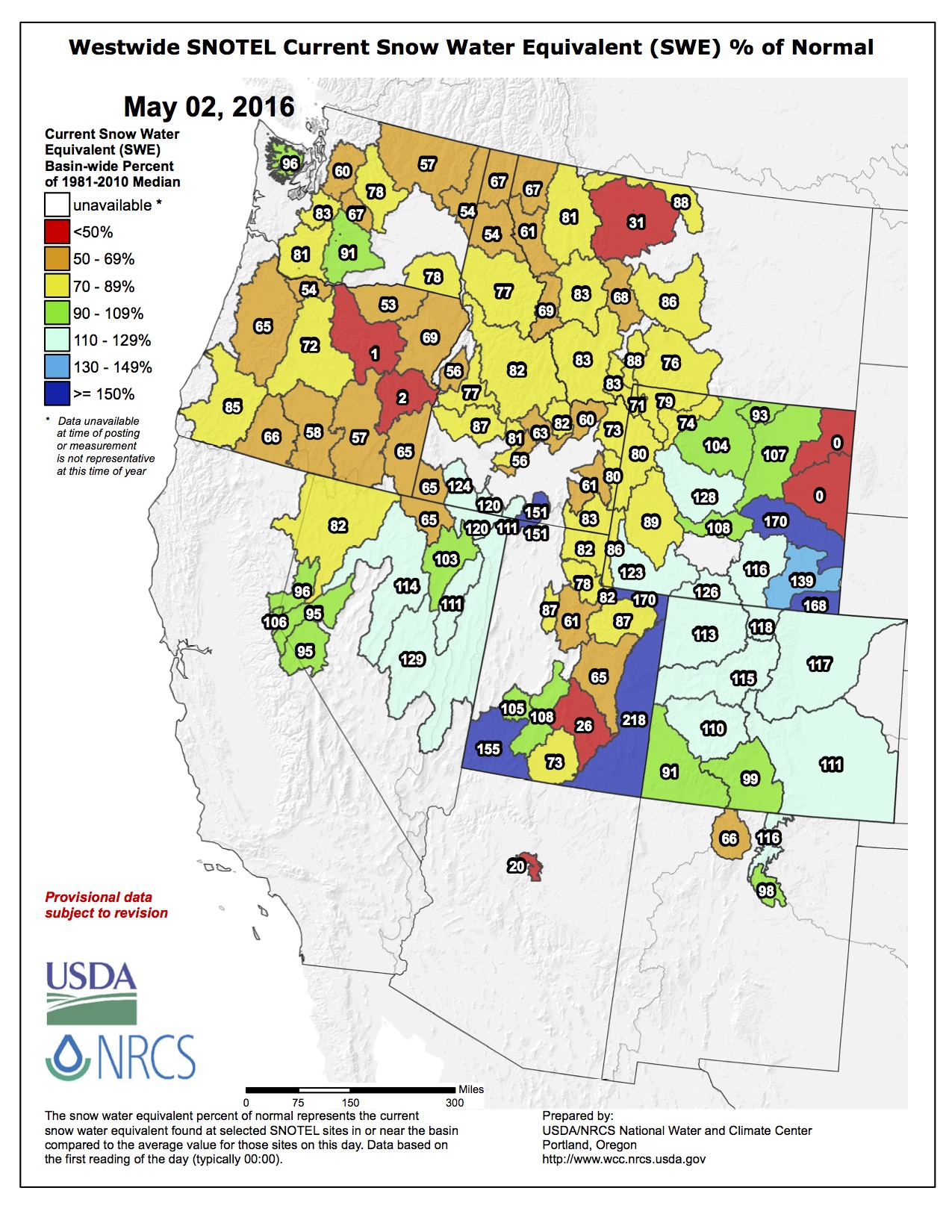
The majority of debt in the town of about 22,000 is related to water and wastewater projects needed to accommodate a projected build-out population of 65,526 by 2055, according to the town’s 2005 Comprehensive Plan.

“Town boards embarked on a program to plan for, then encourage, then accommodate all that growth,” Krieger said last year. “Our specific challenge now is to manage our resources and services and retire our debt, which we’re doing. Second, we need to diversify our revenue base.”

The town might be growing at a slower pace than anticipated by previous officials, but Erie’s population still jumped 79 percent from 2000 to 2014, according to the U.S. Census Bureau.

In anticipation of the population boom, Erie acquired about $76.4 million in debt for water-related bonds — about 78 percent of the town’s total debt.

Despite concerns early on about Erie’s debt, officials have said the town’s finances were strong following the trustees’ review of the 2016 budget proposal…

“The fact is that the town is rather effectively servicing our debt and three times in the last year Moody’s and S&P increased our credit rating,” [Diehl] said. “They’ve done so in recognition of our efforts to manage our finances and as an indication that the town’s financial outlook is strong.”

Sterling: Precipitation events cause headaches for wastewater infrastructure

Wastewater Treatment Process

From the Sterling Journal-Advocate (Sara Waite):

Rob Demis of Hatch Mott MacDonald didn’t have good news when he gave an update on his company’s review of Sterling’s wastewater treatment plant during Tuesday’s Sterling City Council meeting.

The engineering firm, which was contracted by the city to look at what improvements will be needed at the plant, has been working on the review for three months, but they are still looking at the data and developing preliminary alternatives.

The company has identified two primary issues facing the city’s system: flooding and improvements necessitated by upcoming changes to regulations.

Demis noted that the system has experienced multiple flooding events at the headworks facility in the last five years, from flooding of the river and heavy rainfall events. The flooding damages to equipment and pumping, overloads the pumping system and treatment plant, overflows into the river and leads to violations of the city’s wastewater permit. Each event can cost around $50,000 to $75,000 to replace the damaged equipment.

Inflow and infiltration are the factors that lead to flooding. The water comes from leaky pipe joints, roof drain connections, leaky manholes, missing manhole covers — storm water coming into the waste water system — as well as leaky customer sewer lines and sump pumps, Demis said. He added that Sterling’s system is relatively old; the design life of pipes is about 50 years, so pipes that have been in the ground since 1966 or earlier are at the end of their useful life. “It’s now time to start thinking about fixing them, or at least trying to slow down the amount of leaks,” he said.

He showed a graph that looked at a significant rain event. Prior to the storm, the typical influent flow to the system was averaging about 1.7 million gallons per day. The rain event exceeded the system’s pumping capacity, so the total amount of inflow isn’t known, but Demis noted that for two weeks following the storm, inflow remained above average. He said that is due to infiltration from groundwater leaking into the sewer system.

Sterling needs a larger pumping capacity, and with it a larger pipe to carry the waste water to the treatment plant. Demis said the city also needs to put in 30 million gallons of storage so when there is above average flow, that water can be fed slowly into the treatment plant and allow the biological processes to occur, which prevents violations.

Changes to regulations as soon as next year will require additional processes at the treatment plant. In November 2017, Sterling will have to meet a Total Inorganic Nitrogen (TIN) limit of 10 mg/L of Nitrogen when discharging to the recharge basins, which it cannot do. By 2022, the city will face limits on nitrogen and phosphorus that it also cannot meet.

The city will need additional tanks and chemical systems for nutrient removal as well as new process equipment, and new clarifiers as the existing ones are at the end of their life. The new equipment will necessitate upgrades to the electrical system, and they will need to implement a process control system to ensure they are meeting the requirements.

Demis noted that nitrogen and phosphorus are popular fertilizers, and they promote the growth of algae, which can kill fish.

Demis told the council he would make further presentations as they complete analysis of the data and the options available to the city.

#Snowpack / #Runoff news: Recent snow bumps % of avg

Click on a thumbnail graphic to view the snowwater equivalent data for your favorite basin. Remember to check the total SWE and where your basin is as a percent of avg peak.

Here’s an explainer that I wrote last year about the considerations of percent of avg after runoff had started.

From The Denver Post (Bruce Finley):

Snow and rain pushed Colorado into a comfortable position for water ahead of the wildfire season and dry months when farmers rely on mountain snowpack for crops.

The latest federal data Sunday showed snow levels above the median across the northern half of the state. Snowpack hit 116 percent of the median in the South Platte River Basin, which supplies metro Denver and northeastern Colorado, compared with 95 percent last year.

The heavily-tapped Colorado River Basin held snowpack at 114 percent of the median.

In southern Colorado, Arkansas River Basin snowpack measured 109 percent of the median — just as Colorado Springs begins drawing more heavily from Pueblo Reservoir. Southwestern Colorado snowpack in the San Miguel and San Juan river basins held at 87 percent of the median snowpack. Snowpack along headwaters of the Rio Grande River was at 94 percent.

From The Denver Post (Yesenia Robles):

Denver’s recent weekend snowstorms made April one of the snowiest in history.

As of Saturday afternoon, the total snowfall for last month stood at 15.6 inches, as recorded at Denver International Airport — far above the April average of 8.9 inches.

Snow, traces of which fell through the day and were expected to continue through the night, could push April’s total snowfall into the record books.

The 20th-snowiest April on record since 1882 brought 16.1 inches of snowfall in 1924 — just a half-inch more than what had been recorded Saturday afternoon…

Among the snowiest Aprils in Denver history are those of 1973, with 24.8 inches; 2013, with 20.4 inches; and 1999, with 19.7 inches.

The city’s snowiest April came in 1933, with 33.8 inches.

For the season total, Denver could also be reaching records this year.

So far in the 2015-16 season, the Weather Service has recorded 72.8 inches, making it the 26th snowiest since 1882-83.

The most recent season with more snow was 2012-13, which recorded 78.4 inches. The snowiest season ever recorded was in 1908-09, with 118.7 inches.

From The Crested Butte News (Alissa Johnson):

“Our user group represents five different categories of use on the Taylor River and none of the five representatives are satisfied with the current amount of water available,” said Frank Kugel, general manager for the Upper Gunnison River Water Conservancy District (UGRWCD).

Kugel explained that the Taylor Local Users Group—which is made up of representatives from boating, fishing, property, irrigation and flat-water recreation interests—requested changes to the proposed operations plan, including provisions for more flows in the latter half of July and reduced flows in October. Yet representatives at the meeting, which also included the UGRWCD and the Bureau of Reclamation, also opted to wait until May to finalize the plan.

“We were heartened by the fact that the snowpack went up a bit last week, another 2 percent on the inflow forecast [into Taylor Park Reservoir]. Every little bit helps, and we’re hoping for more this week the way storms have lined up in the forecast,” Kugel said.

At the time of the meeting, that put projected inflows into Taylor Park Reservoir at 82 percent of normal for the April through July inflow period. By Monday of this week, that projection had dropped to 79 percent. Unless April and May bring significant moisture, that means the reservoir is unlikely to fill.

“As envisioned right now flows would be significantly less than last year and that’s primarily due to the miracle May we received. Last year it rained much of May and into early June and we received a great deal of wet snow in the high country,” Kugel said.

As a result, the reservoir was nearly brimming and kept water managers on their toes, releasing enough water to prevent a spill. According to Kugel, the latest projections mean that, barring similar conditions this spring, there will be less flow than normal on the Taylor River this summer.

The Colorado Basin River Forecast Center will update its forecast on May 1, and the local user group will meet again on May 9 to make any additional changes to the operations plan.

Ultimately, the suggested changes to the operation plan will go to the UGRWCD board of directors for approval and then to what is known as the Four Parties meeting in May. There the UGRWCD, the Bureau of Reclamation, the Colorado River District and the Uncompahgre Valley Water Users will ratify the plan.

Westwide SNOTEL map May 2, 2016 via the NRCS.

“Prior appropriation is a doctrine of scarcity” — Greg Hobbs

Arkansas River Basin via The Encyclopedia of Earth

From The Pueblo Chieftain (Chris Woodka):

If there was a message, it was: Water is everything and it starts here.

Retired Colorado Supreme Court Justice Greg Hobbs held the Arkansas River Basin Water Forum captive for about an hour with a mix of photos that ranged from historic images to family photo albums and a collection of historic maps, which he once owned but has donated to the Supreme Court.

His narrative wove a tale of almost mythical historic figures and hard-nosed facts to describe how Colorado water law took shape.

As is his custom, he opened his remarks with one of his own poems, “Colorado, Mother of Rivers.”

“When I was young, the waters sang of being here before I am, of falling wet and soft and slow to berry bog and high meadow,” Hobbs began, ending with: “I call the scarlet to the jaw as morning calls her own hatchlings, call Yampa, White, the Rio Grande, San Juan, the Platte, the Arkansas.”
Hobbs put a special emphasis on “Arkansas.”

“What a great river,” he gushed, marveling at how the Arkansas River flowed just a few yards from the auditorium at the Salida Steam Plant. “What a historical river this is.”

He then proceeded to take the crowd on a journey through time describing the state and the Arkansas River basin’s formation through civilization.

The Native Americans and Hispanic cultures that first occupied Colorado gave the state clues about how water should be managed. The people at Mesa Verde developed a domestic water system using reservoirs hundreds of years before Europeans arrived and Spanish settlers brought acequias to northern New Mexico to irrigate crops at a time when America was not yet a country.

“The more we get urbanized, the more we get dissociated from the land,” Hobbs said. “We need to recognize our Native American and Hispanic roots.”

North American Indian regional  losses 1850 thru 1890.
North American Indian regional losses 1850 thru 1890.

Maybe that kind of thinking led to his own son’s path in life. Hobbs talked about his son, Dan, who carried a sketch book with him everywhere as a child to plan the farm he one day hoped to own. Dan Hobbs now is a farmer on the Bessemer Ditch.

The elder Hobbs’ interest in water was more shaped by a career as first a water lawyer — he jokingly said it is not an honorable profession — and then as a Colorado Supreme Court Justice for nearly 20 years before his retirement last year.

And an intense interest in history.

Hobbs tried to set the record straight on John Wesley Powell, an early explorer of the Colorado River who argued for division of Montana counties along the lines of watersheds, but is often “misquoted” as trying to divide the entire American West in the same way.

In the Arkansas River basin, the Santa Fe Trail brought the first outside settlers to Bent’s Fort, and the discovery of gold in 1858 led to the formation of the Colorado territory in 1861 — a rectangular shape that took land from Utah, New Mexico, Nebraska and Kansas territories. The action also set up the “Mother of Rivers” status for Colorado, which now encompasses the headwaters for the Platte, Colorado, Arkansas rivers and the Rio Grande.

In 1861, Colorado developed the first concept that makes its water law unique, the idea that water can be separated from the land. Unlike a riparian system, Colorado water can be moved to farms that are not located beside a river. It set up a system of prior appropriation, where the first farmer to use the water is entitled to the first diversion.

When Colorado became a state in 1876, another layer of law was added to declare public ownership of the water, rather than individual users.

“What a profound statement our ancestors made,” Hobbs said.

As a result, the senior agricultural water rights remain the most valuable in Colorado, Hobbs said.

“We have a system in place where we can transfer water rights, and the most valuable water rights are our senior water rights,” Hobbs said.

He called periodic attempts to change Colorado’s system to a market- based exchange at one end of the spectrum or a public trust doctrine at the other are equally dangerous because they could leave some without water.

“Prior appropriation is a doctrine of scarcity,” Hobbs emphasized.

During his talk, he also outlined Native American water rights, the formation of compacts with other states, the development of cities on agricultural land and his personal reflections on state water leaders like Wayne Aspinall, Felix Sparks, Jim Isgar and Diane Hoppe.

It was like watching a river of information flow quickly by, hard to grasp in one sitting. Understanding water is like another passage from Hobbs’ poem: “And shape the stones to carry me, when I am young and full of fight for roaring here and roaring there, for pouring torrents in the air.”

rifflesaspenjournalismbrentgardnersmith

Interior official looks toward Roan — The Grand Junction Daily Sentinel

From The Grand Junction Daily Sentinel (Gary Harmon):

The Roan Plateau is high on Interior Secretary Sally Jewell’s list of issues to be resolved in the remaining months of the Obama administration.

Jewell recently discussed the next 100 years of conservation and a “course correction” before the National Geographic Society.

The Interior Department has “some work left to re-examine whether decisions made in prior administrations properly considered where it makes sense to develop and where it doesn’t,” Jewell said. “Or where science is helping us better understand the value of the land and water and potential impacts of development. Places like Badger Two-Medicine in Montana, or the Boundary Waters in Minnesota, or the Roan Plateau in Colorado.”

Jewell’s comments, however, left some Colorado officials questioning whether they signaled a change in the direction of the management of the Roan.

The Bureau of Land Management is completing an environmental study of the area. BLM, industry and environmental groups and local governments in late 2014 reached an agreement to cancel 17 of the 19 leases issued on the plateau in 2008. The remaining two leases on top and 12 leases at the base of the plateau were to remain in place.

Jewell was referring to the plan now under study by the BLM, the Interior Department said…

The Roan Plateau was managed by the U.S. Department of Energy as an oil shale reserve until 1997, when President Bill Clinton signed legislation transferring the area to the BLM.

The act required the BLM to manage the area for multiple use and instructed the agency to begin leasing it for oil and gas development.

“We hope the secretary’s mention of the Roan Plateau bodes well for the future of the area,” said Luke Schafer, West Slope Advocacy director for Conservation Colorado, urging the BLM to complete the management plan “to protect the pristine lands, rare species, and remarkable habitat on the Roan.”

The directive to lease the area, however, remains, said David Ludlam, executive director of the West Slope Colorado Oil and Gas Association.

Jewell’s “policies may contribute to compliance with that law taking decades rather than years,” Ludlam said, “but for the benefit of future generations we will never stop advocating for the responsible development that must and someday will occur on the Roan Plateau.”

2016 #coleg: Gov. Hickenlooper signs HB16-1109 (Application Of State Water Law To Federal Agencies)

Photo via Bob Berwyn

From The Vail Daily (Randy Wyrick):

Colorado lawmakers unanimously made federal water grabs almost impossible.

The Colorado Water Rights Protection Act passed both the Colorado House and Senate without a single dissenting vote. The bill thwarts federal efforts to control or own water that begins on or passes through federal land, and to do so without paying for it.

That’s important in our region because about 80 percent of Eagle and Summit counties are federal land, said Glenn Porzak…

In fact, the Eagle River Water & Sanitation District and Upper Eagle Regional Water Authority both have water infrastructure on federal lands.

Rick Sackbauer, Eagle River Water & Sanitation District board chair, called the bill “a great victory for water right holders in the Eagle River valley and throughout Colorado.”

“The authority and other water providers have made enormous financial investments in water rights and water infrastructure in reliance on state laws,” said George Gregory, Upper Eagle Regional Water Authority board chair.

WATER RIGHTS TRIFECTA

Porzak with Porzak, Browning & Bushong, is water counsel for Eagle River Water & Sanitation District, Upper Eagle Regional Water Authority and many others. He worked on the bill for three years.

Porzak said the legislation does three things:

1. Forces the feds to buy water rights, instead of taking them by manipulating policy.

2. Forces the feds to go through state water court, in compliance with federal law.

3. Orders Colorado’s state engineer not to enforce any water rights restriction by the U.S. Forest Service or the Bureau of Land Management, and provides tools for water right holders to fight these agencies in court if necessary.

In other words, if the feds want water rights, then they have to buy them, like everyone else does.

“Water rights are a saleable commodity,” Porzak said. “They’re trying to get the water for free. This bill creates a financial disincentive. They (the feds) can issue a directive, but they do so at their peril.”

Trail map for Powderhorn Ski Area via liftopia

WHY IT BEGAN

The impetus for the bill began in 2012, when the Forest Service demanded that ski areas, in exchange for renewing their leases on public land, turn over their private state issued water rights to the federal government.

The ski areas sued and the U.S. Forest Service lost on procedural grounds. The Court ordered the Forest Service to go back to the drawing board, and while improvements have been made in the context of ski area policy, the Forest Service has subsequently issued other policy directives that raise additional concerns for private water right holders throughout Colorado.

The Forest Service said it was trying to make sure water rights stay with the ski areas, and aren’t sold separately if the ski area is sold.

“This legislation is not pie in the sky. It has real substance to it,” Porzak said.