Here’s the latest Intermountain West Climate Dashboard from the Western Water Assessment

US Drought Monitor April 11, 2017.

Click here to go to the website. Here’s an excerpt:

Highlights:

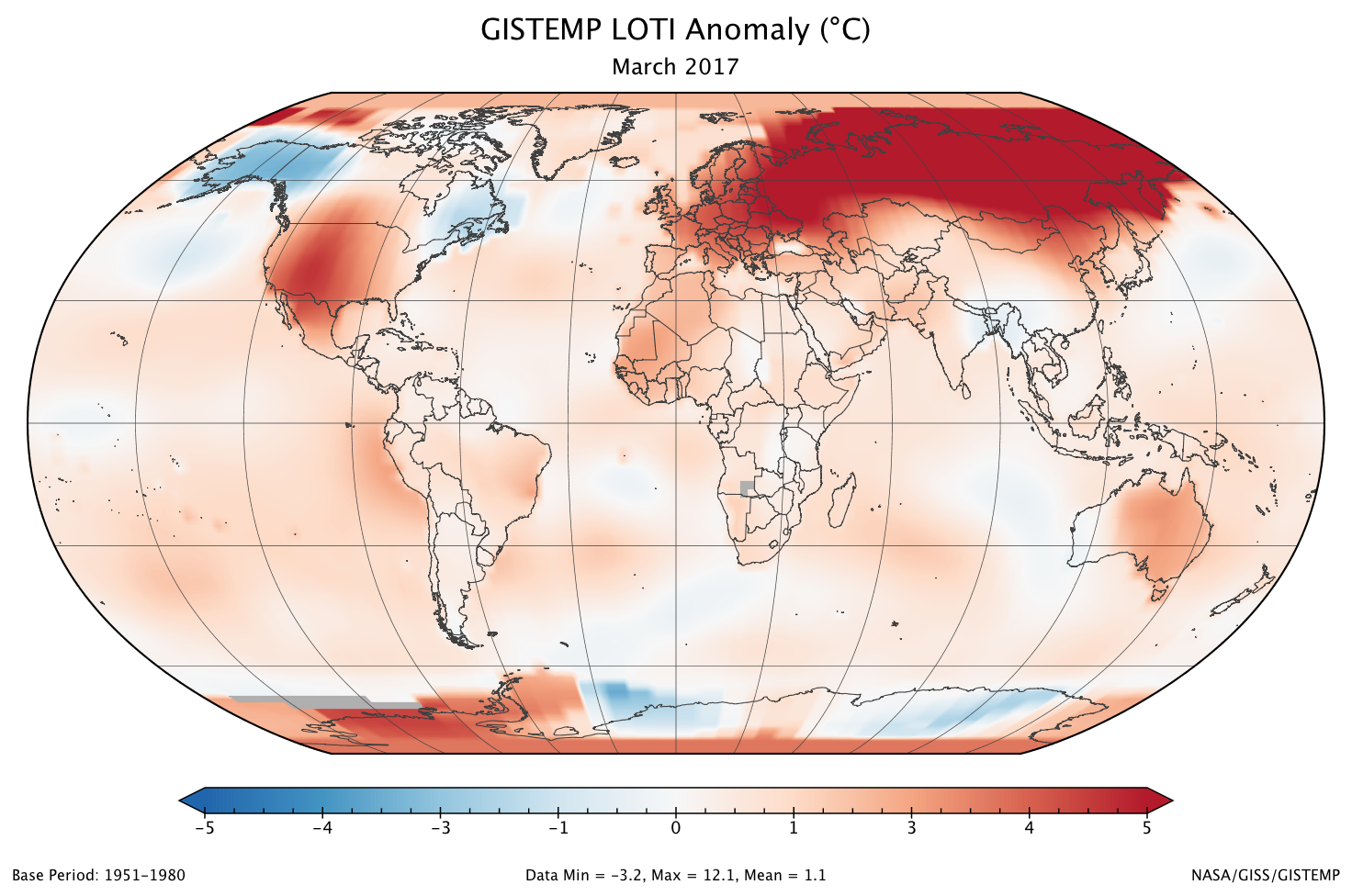
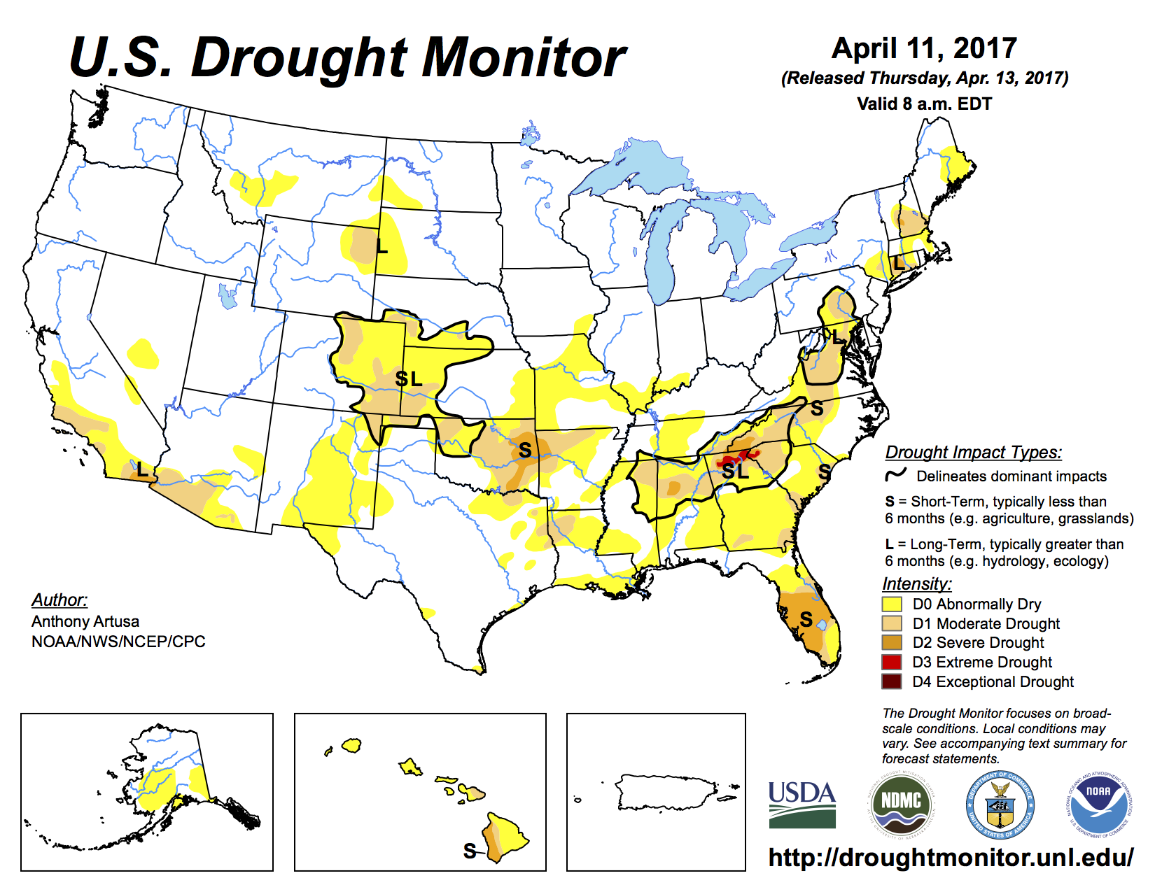
  • Very warm and dry conditions the first three weeks of March caused unusually early snowmelt across the region, with significant or complete meltout at low and middle elevations in many basins, and substantial SWE losses at some high-elevation sites. A return to an active storm pattern put accumulation back on track so that as of April 7th, SWE in most basins was still well above normal.
  • With the large snowpacks and early snowmelt, daily streamflows in northern Utah and western Wyoming rivers are at high (>90th percentile) or record-high values, including the Provo, Weber, Ogden, Bear, upper Green, Snake, Wind, Bighorn, and Yellowstone. There is an elevated risk of flooding in these basins as spring runoff progresses.
  • The April 1 NRCS spring-summer runoff forecasts came in lower than the March 1 forecasts at most points, though the regional picture is still dominated by above-average runoff. Forecast points in northern Utah and western Wyoming are expected to have >150% of average runoff, while points in Colorado, southern Utah, and eastern Wyoming, are split between the below-average (70-89%), near-average (90-109%), and above-average (110-129%; 130-149%) categories. Forecasted Lake Powell inflows have slipped to 130% of average, per both NRCS and NOAA CBRFC.
  • With the boost from storms late in the month, central and western Wyoming, much of Utah, and far eastern Colorado ended up with well-above-normal precipitation. Northwestern and southern Utah, northeastern and south-central Wyoming, and western and north-central Colorado stayed well on the dry side. Statewide, Wyoming was yet again very wet, in the 89th percentile for precipitation, with Utah in the 65th percentile and Colorado in the 34th percentile.
  • Like February, March ended up as very warm across the region, with temperature departures of +2°F to +10°F. Colorado had its warmest March on record, 6.4°F above normal, while Utah saw its 2nd-warmest March, and Wyoming, its 4th-warmest March.
  • Drought conditions have improved in central Utah and areas of eastern Colorado since early March, but deteriorated in other areas of eastern Colorado. D1 or D2 conditions now cover 22% of Colorado (down from 37%), 9% of Wyoming, and 0% of Utah.
  • The tropical Pacific remains in ENSO-neutral conditions, though with warming sea-surface temperatures off the Peruvian coast in the Niño 1+2 region. The ENSO forecast models call for neutral conditions to continue through spring, with in increasing chance of El Niño conditions by fall.
  • 2017 #Colorado wildfire outlook

    From the Associated Press (Dan Elliott) via US News & World Report:

    Colorado can expect an average to slightly below-average wildfire season this year, despite dry conditions and early outbreaks on the eastern plains, officials said Friday.

    “But the fires will occur,” said Michael Morgan, the director of state Division of Fire Prevention and Control.

    An average season in Colorado is about 45 wildfires burning a total of 160 square miles (415 square kilometers), Morgan said.

    The outlook is based on expected weather patterns and fuel — the trees, grass, shrubs and other vegetation that can burn if a fire gets out of hand.

    Most of the plains have been in a drought or near-drought conditions since mid-October. Last month, a wildfire in northeastern Colorado blackened 50 square miles (129 square kilometers) and killed 200 cattle.

    But the mountains received heavy winter snowfall after a slow start. Most of the high country had average or above-average snowpack as of Friday.

    Gov. John Hickenlooper, who appeared with Morgan for a briefing at the state Capitol in Denver, said Colorado averages four times as many wildfires as it did 15 years ago. He blamed climate change, which he said has lengthened the fire season by about 80 days…

    Only about 7 percent of the state’s 2016 wildfires had natural causes, Morgan said. The rest were started by debris fires, campfires, prescribed burns, arson, mechanical failures or other causes, he said.

    The state has adopted an aggressive tactic of monitoring for wildfires when conditions are dangerous and attacking them quickly, from the air if necessary, when they are reported.

    Two years ago, the state rolled out two newly acquired aircraft equipped with infrared cameras, which officials said were so sensitive that one detected a campfire from 28,000 feet (8534 meters) in the air.

    Morgan said the aircraft detected 43 fires last year that were so remote no one else had reported them.

    Black Forest Fire June 2013 via CBS Denver

    BLM accepting comments on Upper #ColoradoRiver management #COriver

    Gore Canyon rafting via Blogspot.com

    Here’s the release from the Bureau of Land Management:

    The Bureau of Land Management seeks public input as it begins updating a management plan for about 40 miles of the Upper Colorado River between Parshall and State Bridge.

    The Recreation Area Management Plan update will guide the specific management of the Upper Colorado River Special Recreation Management Area (SRMA) within the Kremmling Field Office, an extremely popular area for commercial and private float-boating and fishing. More than 90,000 people visit the area each year.

    “The original management plan for the area dates back to 2000, and a lot has changed since then,” said BLM Kremmling Field Manager Stephanie Odell. “We want to hear what the public would like us to address – things like ways to reduce crowding and user conflicts, potentially improving facilities, balancing use with conserving the natural resources of the area, or any other issues.”

    The BLM is hosting three public open house meetings to answer questions and accept written comments:

    • April 18 from 4-6 p.m. in Silverthorne at the Summit County Library, 651 Center Circle

    • April 20 from 4-6 p.m. in Kremmling at the CSU Extension Hall, 210 11th St.

    • April 21 from 6-8 p.m. in Denver at the REI Flagship Store, 1416 Platte St.

    The BLM Kremmling Field Office collected more than $220,000 in commercial and recreation fees from the Upper Colorado River SRMA last year. These funds are used to manage the SRMA. Recreation on BLM lands in the Kremmling Field Office supports an estimated 280 jobs generating $8.4 million in labor income annually.

    More information about the management plan update is available at: http://bit.ly/2obaSen

    Comments must be received by May 15 and may be e-mailed to blm_co_kr_webmail@blm.gov or mailed to Bureau of Land Management, Attn: Shane Dittlinger, P.O. Box 68, Kremmling, CO 80459.

    Before including your address, phone number, e-mail address, or other personal identifying information in your comment, you should be aware that your entire comment—including your personal identifying information—may be made publicly available at any time. While you can ask us in your comment to withhold your personal identifying information from public review, we cannot guarantee that we will be able to do so.

    @NASAClimate: March 2017 Was Second Warmest March on Record

    The GISTEMP monthly temperature anomalies superimposed on a 1980-2015 mean seasonal cycle. Credit NASA.

    From NASA:

    March 2017 was the second warmest March in 137 years of modern record-keeping, according to a monthly analysis of global temperatures by scientists at NASA’s Goddard Institute for Space Studies (GISS) in New York.

    Last month was 1.12 degrees Celsius warmer than the mean March temperature from 1951-1980. The two top March temperature anomalies have occurred during the past two years.

    March 2016 was the hottest on record, at 1.27 degrees Celsius warmer than the March mean temperature. March 2017’s temperature was 0.15 degrees Celsius cooler than March 2016, but 0.2 degrees Celsius warmer than any previous March.

    The monthly analysis by the GISS team is assembled from publicly available data acquired by about 6,300 meteorological stations around the world, ship- and buoy-based instruments measuring sea surface temperature, and Antarctic research stations.

    The modern global temperature record begins around 1880 because previous observations didn’t cover enough of the planet. Monthly analyses are sometimes updated when additional data becomes available, and the results are subject to change.

    Global map of the March 2017 LOTI (land-ocean temperature index) anomaly shows that Europe and all of Russia (especially north central Siberia) were again much warmer than the 1951-1980 base period. Much of the United States was also relatively warm, but Alaska was instead cool. Credit NASA.

    Carbondale micro hydro project cruising to approval — @AspenJournalism

    Micro-hydroelectric plant

    From Aspen Journalism (Brent Gardner-Smith) via The Glenwood Springs Post-Independent:

    On March 9 the town of Carbondale notified the Federal Energy Regulatory Commission it plans to install a micro hydropower turbine in a pipe leading to its municipal water treatment plant on Nettle Creek.

    On March 13 FERC found that Carbondale’s project qualified for a quick review under the Hydropower Regulatory Efficiency Act of 2013, which streamlined the permitting process for hydro projects of less than 5 megawatts.

    And by April 27, if no one claims the project doesn’t qualify, the town can expect to get a letter from FERC saying the town does not need a license and can go ahead, at least as far is FERC is concerned.

    At 28 kilowatts, Carbondale’s project is much smaller than the 5-megawatt limit in the efficiency act, it’s a new license using a nonfederal pipeline, and it complies with the Federal Power Act.

    So far, FERC’s fine with it, and it’s received no objections from the public.

    The project involves installing a “turbine/generating unit” in an existing 10-inch municipal pipeline, or “raw water intake line.”

    The pipe is 1,800 feet long and transports about 1 cubic foot per second of water downhill from Nettle Creek to the city’s treatment plant. The plant is eight miles up the Crystal River valley on the lower slope of Mount Sopris.

    The turbine would be built inside a vault installed in the pipeline, near the treatment plant. A short bypass system would allow water to be moved around the turbine for repairs and maintenance.

    “It’s taking advantage of the water that is already going down that pipeline,” said Mark O’Meara, Carbondale’s utilities director. “We’re not going to increase it. We’re not going to be doing any additional diversion.”

    O’Meara also said that since it’s a nonconsumptive use of water already running down a pipeline, the town did not have to change its existing municipal water rights to specifically add hydro as a use.

    The turbine’s “installed capacity” of 28 kilowatts and its “estimated annual generating capacity” of 190,000 kilowatt-hours is about enough electricity to offset the amount of power used to run the water plant, O’Meara said.

    According to Craig Cano, a media relations officer at FERC, the 28 kilowatt figure refers to how much power the turbine could produce at any moment.

    “That’s real small,” Cano said, pointing out it’s 0.028 of a megawatt, while a typical baseload-generating power plant’s capacity is in the hundreds of megawatts.

    The 190,000 kilowatt-hour figure refers to the total amount of energy produced over a year.

    The resulting electricity would either be sent through the existing Holy Cross Energy system that today powers the plant, or perhaps be used directly in the plant, O’Meara said. The town would get credit from Holy Cross for hydropower sent out over the grid.

    The project has been in the works since the 1990s, but it still has a long way to go.

    On the list is an in-depth feasibility study considering design, engineering and cost. A 2012 estimate from engineering firm SGM put the cost at $180,000. O’Meara did not have an updated cost.

    And since the water plant and pipeline are on U.S. Forest Service land, the agency also has jurisdiction over the project.

    But O’Meara said after going to a recent workshop put on by the Colorado Energy Office, it seemed like the right time for the town to enter the streamlined FERC process and see how it goes.

    It took only four days after receiving Carbondale’s “notice of intent” for FERC to issue its “notice of preliminary determination” that the project qualified for speedy review.

    That notice, along with town’s initial notice, are on town’s website, on its utilities page.

    Also on March 13, FERC opened two windows for parties to contest the qualifications of the project.

    The first was a 30-day window to file a motion to intervene. By April 12, no one had.

    The second was a 45-day window for less formal but still “contesting” comments to be made.

    That window closes April 27, and as of April 13, FERC had received no comments.

    “If no party contests staff’s initial determination that the project meets the criteria for a qualifying conduit hydropower facility within the 45-day public notice period,” FERC’s Cano said, “the facility is deemed to meet the criteria and FERC staff shortly thereafter will issue a letter notifying the filer that is project has met the criteria.”

    If someone does file a comment contesting the project’s qualifications, FERC is supposed to then “promptly issue a written determination as to whether the facility meets the criteria,” Cano said.

    Carbondale’s O’Meara said that as far as he knows, no one over the years has raised concerns about the project directly to the town.

    Aspen Journalism is collaborating with the Post Independent, The Aspen Times, the Vail Daily and the Summit Daily News on coverage of water in the upper Colorado River basin. More at http://www.aspenjournalism.org.

    #Runoff news: Big McPhee spill this season into the Dolores River

    Ponderosa Gorge, Dolores River. Photo credit RiverSearch.com.

    From The Durango Herald editorial board:

    This year’s spill from McPhee Reservoir will be lengthy. Snowfall was particularly good this year. But a steady release is not what appeals to boaters. Better to vary the flow from high to medium levels to give river runners different experiences in the canyon…

    A big Dolores spill does not occur often (the most recent of any size was in 2008), thus there are good reasons for making the most of it this year. Expect the river, ecology and terrain to be subjected to its dynamism.

    Sediment movement with different flows is important as the river adjusts its pools and eddies while refreshing itself. And to what degree an underground aquifer will replenish depends on higher flows.

    While Southwest Colorado will enjoy making the most of the Dolores, there are plenty of uncertainties about how to fund other water projects needed for a state population expected to double by 2050 (requiring an estimated 560,000 acre feet of water).

    Both conservation and more efficient water uses are in the equation, but project funding is elusive. Severance taxes provide the bulk of the funding for the Department of Natural Resources, but energy extraction is not providing a predictable revenue source.

    From Steamboat Today (Tom Ross:

    Flows on the Yampa River this week more closely resembled conditions typical of mid-July than mid-April, and federal scientists who keep an eye on the entire Colorado River Basin are now predicting that flows in the river, which runs through the heart of downtown Steamboat Springs, will trend below average through mid-summer.

    “The headwaters of the Colorado River main stem and the San Juan Basin are currently forecast to receive near average runoff volumes, while the Yampa and White river basins now have forecasts for below average April-July runoff volumes,” hydrologists at the Colorado Basin River Forecast in Salt Lake City predict.

    The Yampa was flowing at 309 cubic feet per second (cfs) at the Fifth Street Bridge in downtown Steamboat Springs at midday on April 13. That’s below the median for the date of 440 cfs. But this isn’t likely to be a replay of 2012 when the river peaked unusually early for the season at 1,570 cfs on April 27.

    There is still 38 inches of snow on the West Summit of Rabbit Ears Pass, according to the Natural Resources Conservation Service.

    Based on weather forecasts, the River Forecast Center expects the Yampa in Steamboat to spike to just over 400 cfs Friday, April 14 in the wake of temperatures pushing 70 degrees on Thursday, then retreat to below 230 cfs by April 21.

    It’s a different story on the Elk River, which flows into the Yampa west of Steamboat. Contrary to the trend on the Yampa, the Elk was flowing well above average Thursday at 1,080 cfs, compared to the median 641 cfs…

    The historic average peak flow for the Yampa is 3,070 cfs at the Fifth Street Bridge. The river peaked at 3,550 cfs on May 5, 2015, and at 3,430 cfs on June 9, 2016.

    One of the heaviest runoffs this decade was in 2011, when the river peaked at 5,200 cfs on June 7. The highest recorded peak flow was 6,820 cfs on June 14, 1921, in an era when there were fewer dams upstream from Steamboat.