Here’s the release from the NRCS (Brian Domonkos):
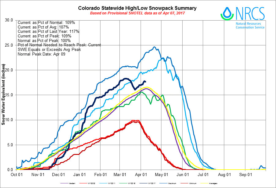
Unseasonably warm and dry weather dominated the first two-thirds of March in Colorado and much of the inter-mountain western United States. Many automated SNOw TELemetry (SNOTEL) measurement stations in Colorado were unable to escape the heat including a substantial portion of the higher elevation locations which lead to early season snowmelt. On April 1st statewide snowpack was at 108% of normal, down from 139% of normal last month and 156% on February 1st. “It has been a bit of a rollercoaster snowpack season,” says Brian Domonkos, Colorado Snow Survey Supervisor, referring to record low snowpack accumulation in October & November, followed by record high snowpack accumulation in December and January, and now a return to near record low snowpack accumulation again in March. Relatively good snowpack remains in the Gunnison, Arkansas, and combined San Miguel, Dolores, Animas and San Juan Basins all above 118% of normal. Only the combined Yampa & White Basins are now below normal.
Statewide Basin High/Low graph April 7, 2017 via the NRCS.
March precipitation statewide was 64% of average with two SNOTEL sites recording as low as 20% of March normals. These low monthly totals dragged down the year-to-date precipitation from 123% of average last month to 112% on April 1st. Fortunately, some recovery came at the month’s end to much of Colorado’s mountains mostly in the form of snow. The South Platte, Arkansas and the Rio Grande basins did receive enough snow to reach new snowpack peaks beyond the peak reached in early March. Snowpack typically peaks for all basins near April 10th, the exception being the South Platte, which peaks two weeks later. With the peak date a few short days away it is increasingly likely all but the South Platte, Arkansas & Rio Grande experienced their peak in early March of this year.
At the end of the month the Sangre de Cristo Mountains were able to scrounge up considerably more precipitation than the rest of the state, helping to boost the late season snowpack in that region. “March and April are the two months in which Colorado typically sees the greatest precipitation, accounting for over one-fifth of the year’s total,” says Domonkos. A slow start in March can be overcome in April. While current snowpack and reservoir storage levels are normal to slightly above normal across much of the state, the recent snowmelt and dry conditions in March had significant impacts. As a result, spring and summer streamflow forecasts have dropped considerably since a month ago.
For more detailed and the most up to date information about Colorado snowpack and supporting water supply related information, refer to the Colorado Snow Survey website at:
One of the generating units at the power plant at Kemmerer, Wyo., is being shut down this year to reduce emissions that are causing regional haze. 2009 photo/Allen Best
…it was little surprise when the federal government reported this week that U.S. coal use fell 9 percent in 2016, even as Americans consumed more energy overall. The U.S. used more natural gas and renewables last year than ever before, while oil use and even nuclear power were on the rise, too…
Coal use fell last year for the third year in a row — after slight increases in 2012 and 2013 — and has been steadily declining in the U.S. since it peaked a decade ago, according to U.S. Energy Information Administration data…
Part of the problem for coal, however, is that Americans aren’t as hungry for electricity as they used to be, thanks in part to more energy efficient buildings and appliances…
Cheap prices along with federal mercury emissions regulations became big incentives for electric companies to build natural gas power plants and shut down their coal-fired power plants, or run them using natural gas instead of coal.
Most Colorado river basins typically see snowpacks growing into the middle of April. But the unseasonably early warmth in early March changed that, with the melt beginning weeks earlier than normal. All of the state’s major river basins saw snowpack declines of 20 percent to 40 percent of normal in March.
Heavy snow and cold temperatures late in the month reversed the trend. But the real luck was the bountiful January, when all but one of Colorado’s seven major river basins saw more than 200 percent of normal snowfall. That January pile up — with snowfall for the record books — can be credited with rescuing Colorado’s water supply this season.
Click on a thumbnail graphic to view a gallery of snowpack data from the NRCS.
Statewide snowpack Colorado April 7, 2017 via the NRCS.
Arkansas River Basin High/Low graph April 7, 2017 via the NRCS.
Upper Colorado River Basin High/Low graph April 7, 2017 via the NRCS.
Gunnison River Basin High/Low graph April 7, 2017 via the NRCS.
Laramie and North Platte Basin High/Low graph April 7, 2017 via the NRCS.
Upper Rio Grande River Basin High/Low graph April 7, 2017 via the NRCS.
San Miguel, Dolores, Animas, and San Juan Basin High/Low graph April 7, 2017 via the NRCS.
South Platte River Basin High/Low graph April 7, 2017 via the NRCS.
Yampa and White Basin High/Low graph April 7, 2017 via the NRCS.
Statewide Basin High/Low graph April 7, 2017 via the NRCS.
“The recent dry spell that we’ve had — recent being February and March — is a bit on the concerning side,” said Brian Domonkos, Colorado Snow Survey supervisor. “It is comforting to know that we had great snow going into the dry spell, but to see some of that early melt-off seems to make runoff less efficient.”
March saw unseasonably dry and warm weather in the mountains, prompting some early snowmelt and bringing a hint of caution to what had been optimistic forecasts about the state’s snowpack…
In the two basins that feed Weld its water, snowpack totals also were above normal. In the Colorado River basin, snowpack was 105 percent of normal on April 1 and 99 percent of last year’s snowpack. Those numbers are down dramatically from the beginning of March, when snowpack was 135 percent of normal and of last year’s snowpack.
In the South Platte basin, snowpack was 103 percent of normal and 98 percent of last year’s total at the start of April. Reservoir storage for the Colorado basin was 108 percent of average and 111 percent of last year’s average reservoir storage. In the South Platte, reservoir storage was 106 percent of average and 109 percent of last year.
Domonkos said Colorado stream flow forecasts are normal to slightly above normal. In the South Platte stream flow forecasts are below normal. He said because all the numbers are so close to their norms, he isn’t concerned about any abnormal risk of flooding this year. Still, the weather in Colorado is unpredictable.
In spite of unseasonably warm and dry weather over the first two-thirds of the month of March, statewide snowpack is hanging in at 111 percent of median, Brian Domonkos, Colorado snow survey supervisor, reported this week. However, the combined Yampa/White river basins represent the only region in the state where snowpack is below average…
According to the National Resources Conservation Service, where Domonkos heads up the Colorado snow survey, snowpack in the two-river basin stood at 86 percent of median on April 1…
He was referring to record low snowpack accumulation in October and November, followed by record high snowpack accumulation in December and January, and a near record low snowpack accumulation again in March…
elatively good snowpack remains in the Gunnison, Arkansas, and combined San Miguel, Dolores, Animas and San Juan basins all above 118 percent of normal. Only the combined Yampa and White basins are now below normal, according to Domonkos.
But the trend has reversed and picked up snowpack modestly since the first of the month. On April 7, it was a tale of two snow measurement sites.
At the Dry Lake site, sitting at an elevation of 8,400 feet, the snowpack was at 77 percent of median. At the top of Buffalo Pass, the Tower site at 10,700 feet had more snow and snow water equivalent, but the latter was just 86 percent of median for that high elevation.
The outlier in the Steamboat area is at a snowpack measuring site on the east side of Rabbit Ears Pass in Buffalo Park. The snowpack there is 142 percent of median. Much of that water will run down Muddy Creek on its way to Wolford Mountain Reservoir north of Kremmling.
The latest spring flood outlook predicts record amounts of water coming down Wyoming mountains this spring and summer in a number of major river basins. Water supply specialist Lee Hackleman of the Natural Resources Conservation Service says record runoff is expected in the Wind, Green, Sweetwater and Shoshone river basins because of the snowpacks that have accumulated this past winter.