Here’s the release from the NRCS (Brian Domonkos):
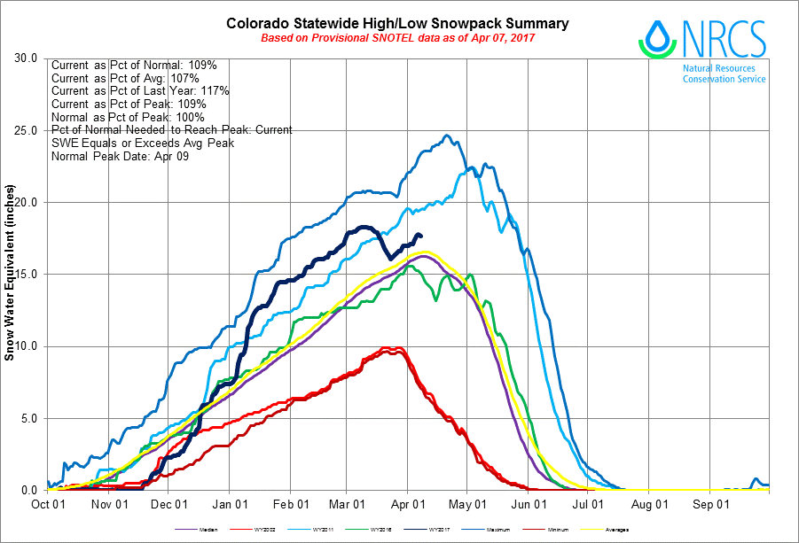
Unseasonably warm and dry weather dominated the first two-thirds of March in Colorado and much of the inter-mountain western United States. Many automated SNOw TELemetry (SNOTEL) measurement stations in Colorado were unable to escape the heat including a substantial portion of the higher elevation locations which lead to early season snowmelt. On April 1st statewide snowpack was at 108% of normal, down from 139% of normal last month and 156% on February 1st. “It has been a bit of a rollercoaster snowpack season,” says Brian Domonkos, Colorado Snow Survey Supervisor, referring to record low snowpack accumulation in October & November, followed by record high snowpack accumulation in December and January, and now a return to near record low snowpack accumulation again in March. Relatively good snowpack remains in the Gunnison, Arkansas, and combined San Miguel, Dolores, Animas and San Juan Basins all above 118% of normal. Only the combined Yampa & White Basins are now below normal.
Statewide Basin High/Low graph April 7, 2017 via the NRCS.
March precipitation statewide was 64% of average with two SNOTEL sites recording as low as 20% of March normals. These low monthly totals dragged down the year-to-date precipitation from 123% of average last month to 112% on April 1st. Fortunately, some recovery came at the month’s end to much of Colorado’s mountains mostly in the form of snow. The South Platte, Arkansas and the Rio Grande basins did receive enough snow to reach new snowpack peaks beyond the peak reached in early March. Snowpack typically peaks for all basins near April 10th, the exception being the South Platte, which peaks two weeks later. With the peak date a few short days away it is increasingly likely all but the South Platte, Arkansas & Rio Grande experienced their peak in early March of this year.
At the end of the month the Sangre de Cristo Mountains were able to scrounge up considerably more precipitation than the rest of the state, helping to boost the late season snowpack in that region. “March and April are the two months in which Colorado typically sees the greatest precipitation, accounting for over one-fifth of the year’s total,” says Domonkos. A slow start in March can be overcome in April. While current snowpack and reservoir storage levels are normal to slightly above normal across much of the state, the recent snowmelt and dry conditions in March had significant impacts. As a result, spring and summer streamflow forecasts have dropped considerably since a month ago.
For more detailed and the most up to date information about Colorado snowpack and supporting water supply related information, refer to the Colorado Snow Survey website at: