Most of us learned as children that the age of a tree could be found by counting its rings. Rings of trees growing in temperate climates can indeed tell their age through their annual rings and also help determine the age of wood used to construct buildings or wooden objects. The ages of wooden objects can be revealed by cross-dating, the process of matching ring patterns between wood samples of known and unknown ages.
Concentric rings of various widths mark the annual growth of trees. Photo by Peter Brown, Rocky Mountain Tree-Ring Research. Photo credit: NOAA
What do tree rings tell us
The underlying patterns of wide or narrow rings record the year-to-year fluctuations in the growth of trees. The patterns, therefore, often contain a weather history at the location the tree grew, in addition to its age. In dry environments, such as the Middle East or U.S. Southwest, tree rings typically record wet or dry years, and in cooler areas (high latitudes or high elevation), the ring widths are often a proxy for temperature.
Archeologists have used the ring patterns in building timbers to estimate construction dates for some of the world’s most famous buildings, including the cliff dwellings at Mesa Verde National Park (nearly 1,000 years old) and the Church of the Nativity in Bethlehem (nearly 1,500 years old).
The Cliff Palace ruins at Mesa Verde were built in the 1200s by the Ancestral Pueblo people, but were abandoned in the late part of the century. Photo by Ken Lund, used under a Creative Commons license.
What’s in NOAA’s tree ring data base?
NOAA National Centers for Environmental Information (NCEI) houses the International Tree-Ring Data Bank (ITRDB), which contains ring width data from forests worldwide, plus ring width data from old buildings, and even from rare Stradivari violins. The ITRDB contains ring width data from trees at over 4,600 locations on six continents, providing tree growth histories from around the world. New additions from field scientists are added regularly.
Climate scientists compare the tree growth records to local weather records. For locations where a good statistical match exists between tree growth and temperature or precipitation during the period of overlap, the ring widths can be used to estimate past temperature or precipitation over the lifetime of the tree.
In many parts of the world, trees can provide a climate history for hundreds of years, with some extending back 1,000 years or more. The resulting climate histories enhance our knowledge of natural climate variability and also create a baseline against which human-induced climate change can be evaluated. NCEI archives these climate reconstructions in addition to the tree ring measurements.
Glimpsing the past
Tree ring data have been used to reconstruct drought or temperature in North America and Europe over the past 2,000 years. For example, tree ring based drought reconstructions for the American Southwest indicate a period of prolonged drought in the late 1200’s. Archeologists believe that the drought was a contributing factor in the Ancestral Pueblo People abandoning the famous cliff dwellings at Mesa Verde, never to return.
Severe drought in the U.S. Southwest in the late 1200s likely contributed to the abandonment of Mesa Verde (marked with open circle) by the Ancestral Pueblo people. Drought maps for the years 1275-1290 reconstructed from tree ring records show that over the 16-year span from 1275-1290, only two wet years occurred. Graphic by Climate.gov, based on summer drought reconstructions from the Living Blended Drought Atlas, courtesy of NOAA and Cook et al., 2010, Journal of Quaternary Science, 25(1), 48-61. doi: 10.1002/jqs.1303.
Changes in the northeastern reaches of Lake Powell are documented in this series of natural-color images taken by the Landsat series of satellites between 1999 and 2017. The Colorado River flows in from the east around Mile Crag Bend and is swallowed by the lake. At the west end of Narrow Canyon, the Dirty Devil River joins the lake from the north. (At normal water levels, both rivers are essentially part of the reservoir.) At the beginning of the series in 1999, water levels in Lake Powell were relatively high, and the water was a clear, dark blue. The sediment-filled Colorado River appeared green-brown. To see the complete series go to: earthobservatory.nasa.gov/WorldOfChange/LakePowell. Photos via NASA
Click here to read the newsletter. Here’s an excerpt:
DROUGHT PLAN SEEMS CLOSER
A Colorado River Drought Contingency Plan to keep water levels in Lakes Mead and Powell from crashing has inched towards completion, as state agencies and key interest groups have endorsed the draft plan over the past month. Endorsing organizations include Nevada water agencies (as reported by the Las-Vegas Review Journal), the Colorado Water Conservation Board and the Colorado River District (despite some reservations, as reported by Aspen Journalism and the Grand Junction Sentinel). Arizona, typically seen as the lone potential hold-out among the states that share the river, has recently made major steps towards an agreement, according to the Arizona Republic. Earlier, the Desert Sun reported that a conflict in a California irrigation district could still complicate adoption of the agreement.
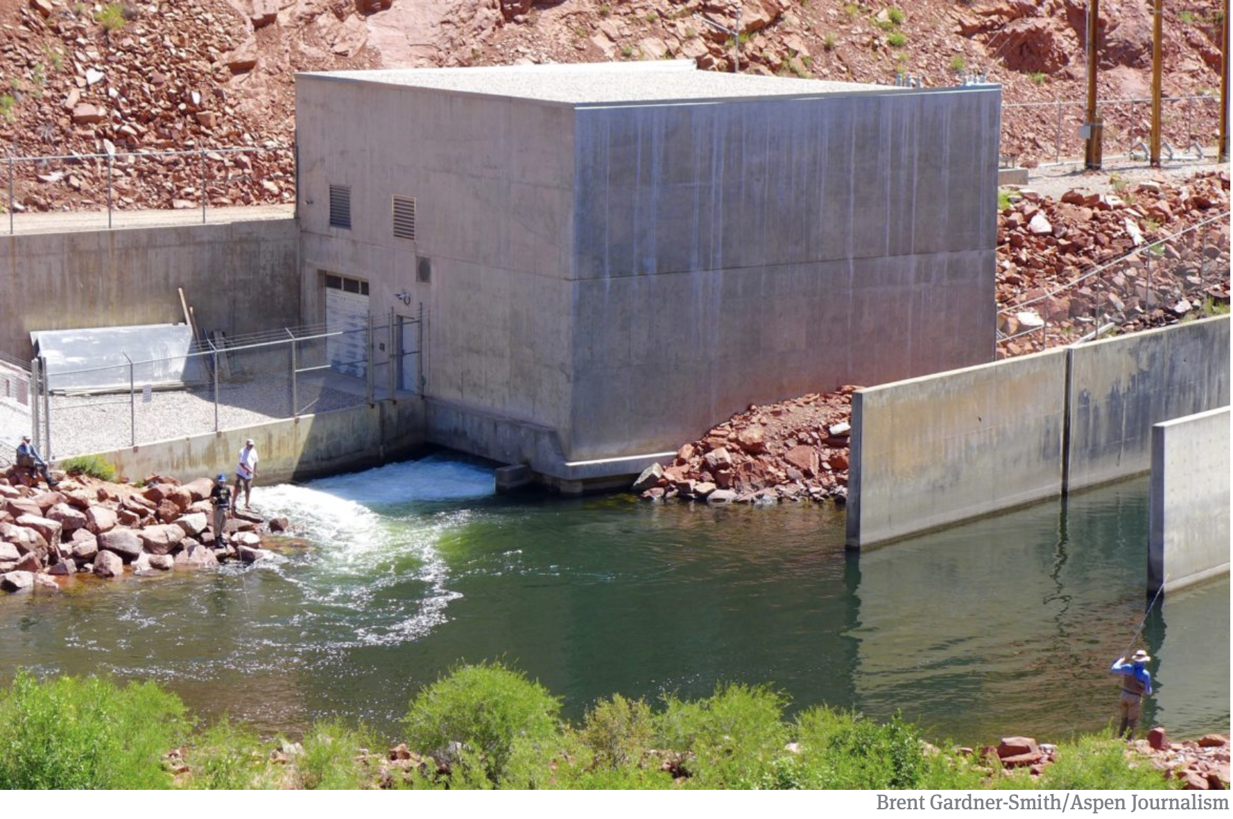
A view of the White River foreground, and the Wolf Creek gulch, across the river. The Rio Blanco Water Conservancy District has been using state funds, and their own, to study two dam options for this area between Meeker and Rangely on the White River. Photo credit: Aspen Journalism/Brent Gardner-Smith
The Colorado Water Conservation Board has given $843,338 to the Rio Blanco Water Conservancy District since 2013 to study a potential dam on the White River, yet officials at the Colorado Division of Water Resources say the project appears “speculative” and Rio Blanco lacks evidence for its claims for municipal, irrigation, energy and environmental uses.
On Nov. 14, the CWCB directors approved the most recent grant application from Rio Blanco for $350,000 to keep studying the proposed White River dam and reservoir project near Rangely.
But while the CWCB is spending more state money to help prepare the White River project for federal approval, another state agency, the Division of Water Resources, is asking hard questions about the project in water court.
“There are concerns whether the district can show that it can and will put the requested water rights to beneficial use within a reasonable period of time and that the requested water rights are not speculative,” wrote Erin Light, the division engineer in Division 6, who oversees the White and Yampa river basins, and Tracy Kosloff, the assistant state engineer in Denver, in a report filed in water court Oct. 4.
In addition to pursuing a series of grants from CWCB, Rio Blanco applied in water court in 2014 for a new water right to store 90,000 acre-feet of water from the White River.
The two engineers in the Division of Water Resources filed their report after consulting with the state attorney general’s office. Review of water rights applications by division engineers is routine, but the report filed by the division engineer and assistant state engineer raised a higher level of concerns than normal.
Also known as the Wolf Creek project, it could store anywhere from 44,000 to 2.92 million acre-feet of water, according to the array of proposals, presentations and applications that have been made public over the project’s ongoing evolution. (Please see: Timeline: tracking the proposed White River dam and reservoir).
The water would be stored either in a reservoir formed by a dam across the main stem of the White River, or in an off-channel reservoir at the bottom of the Wolf Creek gulch.
The latest grant from the CWCB to Rio Blanco was to “finalize the preferred reservoir size and firm-up financial commitments of key project partners so that applications for federal permits can be filed,” according to a CWCB staff memo on the grant.
Asked about the apparent conflict between CWCB and DWR on the White River project, CWCB Director Becky Mitchell said she was aware of the concerns voiced by the division and state engineers and was confident that the next phase of study supported by CWCB would help answer some of the questions raised.
“All of the grants given to Rio Blanco thus far have been all about feasibility, so we are not necessarily in disagreement with DWR, but it needs to trued up,” Mitchell said Tuesday. “There may be concerns with what DWR is stating and the grant will help us evaluate those concerns.”
In another sign of CWCB’s support for the potential project, the agency’s finance section has added a potential $100 million loan to Rio Blanco on a list of potential loans it compiles and publishes as part of the CWCB director’s reports to the agency’s directors.
Brad McCloud of EIS Solutions in Grand Junction is serving as Rio Blanco’s project manager for the White River project.
When asked Tuesday about the contradictory messages sent by the two state agencies, McCloud said, “I think one side is working on one end and the other is doing the other and it’s a good check and balance and the way the system is supposed to work. And there are probably things that will get worked out along the way.”
A view looking downstream of the White River in the approximate location of the potential White River dam and reservoir. The right edge of the dam, looking downstream, would be against the brown hillside to the right of the photo. Photo credit: Aspen Journalism/Brent Gardner-Smith
State questions
In their report filed in water court, the state’s water engineers challenge Rio Blanco oft-stated claim it is seeking the new storage facility at Wolf Creek in order to meet the future water needs of the Town of Rangely, which today takes its water directly from the White River.
“While every case is different and may require evidence tailored to the particular facts of the case, the engineers have not received sufficient evidence to support the district’s claimed water demands for Rangely nor evidence that Rangely intends to rely on water storage in one of the Wolf Creek Reservoirs to meet its demand,” the report from Kosloff and Light says.
The engineers’ report also questions the demand for water in the potential new reservoir from the energy sector.
They said Rio Blanco should, at a minimum, show how much of the 45,800 acre-feet of industrial demand it is claiming is located within the district’s boundaries.
They also say Rio Blanco should make public how much of the demand from the energy sector within the district’s boundaries can be satisfied by the existing water rights of the district.
In addition to challenging Rio Blanco’s claims for municipal and industrial use of water in their 2018 report, Light and Kosloff also question Rio Blanco’s claims for irrigation and environmental uses.
They said a storage report prepared for the project “notes that irrigated acreage and irrigation water demand is projected to decrease in the future” in the area downstream of the reservoir.
And the engineers said they “do not believe that a water right for irrigation use should be awarded in this case.”
And the engineers question Rio Blanco claim that it will release up to 42,000 acre-feet of water from its proposed reservoir to the benefit of endangered fish downstream on the White and Green rivers.
They say an ongoing study has yet to make clear how much water is needed for the endangered fish.
“Long story short, it is still unclear what flows should be used when determining if or how much water needs to be stored to assist with meeting the recommended flows,” the report says. “Until these numbers are known, claiming any quantity of water for these uses is speculative.”
Consultants for the Rio Blanco Water Conservancy presenting a slide earlier this year showing how a dam could be built across the main stem of the White River between Rangely and Meeker. A report from engineers at the Division of Water Resources is questioning the claims made in a water court case in which Rio Blanco is seeking new water rights for the project.
Size in flux
The White River project has a wide range of potential uses, according to Rio Blanco, and it also has a wide range of potential sizes, as various presentations and applications have included potential sizes from 44,000 acre-feet to 90,000 acre-feet to 400,000 acre-feet to 2.92 million acre-feet.
Alden Vanden Brink, the manager of the Rio Blanco district, told the CWCB directors Nov. 14 that his district is not seeking to build a 400,000 acre-foot reservoir, despite the reference in Rio Blanco’s grant application to study a reservoir between 44,000 acre-feet and 400,000 acre-feet.
“The 400,000 is maximum size,” Vanden Brink said. “That is not what the Rio Blanco Water Conservancy District is looking to build. It’s going to take somebody from a way outside source to come to the table for that.”
Vanden Brink said the district was seeking to store “anywhere from 44,000 to about 130,000” acre-feet of water.
However, the grant application from Rio Blanco notes that a 400,000 acre-foot reservoir might have some benefit to the state.
“If the higher end of the storage is implemented, the project has tremendous potential to help the majority of the state of Colorado address Colorado River Compact administration issues,” the grant said.
An earlier study on the dam by W.W. Wheeler and Associates for the Rio Blanco district found it was possible to build a dam on the White River at Wolf Creek that would hold 2.92 million acre-feet of water.
The latest grant application to CWCB from the Rio Blanco district says “the preferred reservoir size will be developed based on the amount of water needed and committed to by key project stakeholders.”
Wade Cox, the president of the Rio Blanco Water Conservancy District, discussed the project in October with the board of the Colorado River District, and referenced the varying potential sizes of the reservoir.
“There is never going to be enough water,” Cox said. “I don’t care how big you build it. Whatever you do, it’s never going to be enough. Somebody somewhere is going to utilize it.”
Editor’s note: Aspen Journalism covers water and rivers in collaboration with The Aspen Times and other Swift Communications newspapers. The Times published the story on Thursday, Nov. 29, 2018.
Heres the release from Governor Hickenlooper’s office:
Governor John Hickenlooper today announced a $10.33 million ALT Fuels Colorado grant through the Colorado Energy Office (CEO) to ChargePoint to build electric vehicle (EV) fast-charging stations along the state’s major transportation corridors. The fast-charging stations will be located in communities at 33 sites across six Colorado corridors comprised of Interstate, State and U.S. highways.
“Fast-charging stations give EV drivers the confidence to reliably travel to all corners of the state,” said Governor John Hickenlooper. “The future of EV travel in Colorado is bright thanks to this new partnership with ChargePoint.”
A lack of EV fast-charging stations along major transportation corridors limits the ability of EV drivers to engage in intra-and interstate travel and represents a major barrier for current and prospective EV owners. The Colorado Electric Vehicle Plan requires the State to build out Colorado’s EV fast-charging infrastructure through public-private partnerships. In April, CEO issued a request for ALT Fuels Colorado grant applications to directly address this requirement. This ALT Fuels Colorado grant also helps implement Colorado’s Beneficiary Mitigation Plan and the State’s commitment to the multi-state Regional Electric Vehicle West Memorandum of Understanding.
“ChargePoint brings technology built for today but capable of serving the next generation of EVs as well, said Colorado Energy Office Executive Director Kathleen Staks. “Charging stations will be placed with well-known site hosts in locations that provide easy access, proximity to amenities and 24/7 charging availability.”
ChargePoint is a national leader in EV charging. The company designs, builds and supports all the technology that powers its charging networks, from charging station hardware to energy management software.
“The transition to electric mobility is upon us, and pioneering states like Colorado are leading the way by supporting a broad charging network that enables long distance electric travel,” said Pasquale Romano, ChargePoint President and CEO. “We share the State of Colorado’s vision of a cleaner, more sustainable electric mobility future, and we look forward to working with the Colorado Energy Office to expand EV charging in the state.”
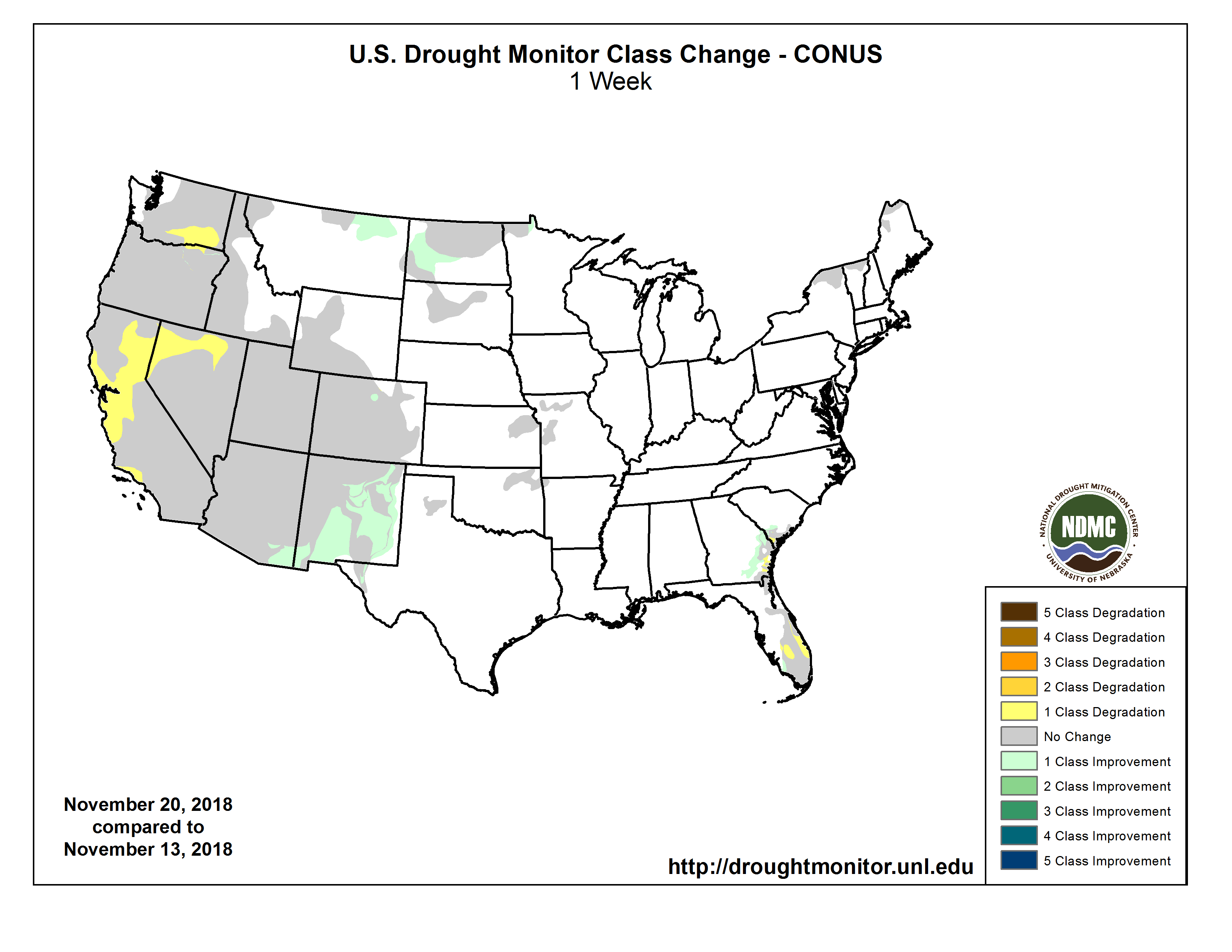
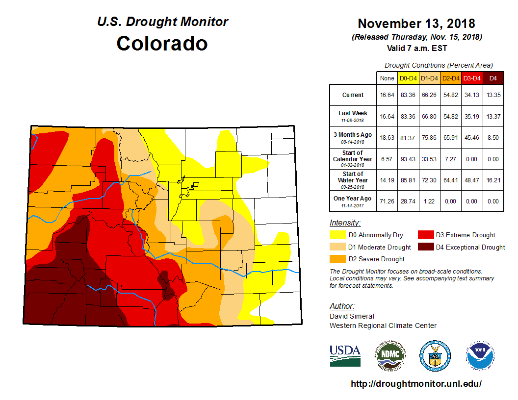
Click here to go to the US Drought Monitor website. Here’s an excerpt:
Summary
A series of upper-level weather systems, and their associated surface lows and fronts, moved across the contiguous U.S. (CONUS) during this U.S. Drought Monitor (USDM) week. They brought beneficial precipitation to much of the Pacific coast; parts of the northern and central Rockies, central Plains, Midwest, and Gulf of Mexico coast; and much of the Mid-Atlantic to Northeast. But they missed much of the Southwest, northern Plains, and southern Plains, where no precipitation, or less than a tenth of an inch, fell. Based on precipitation recorded through the 12z (7:00 a.m. EST) cutoff on Tuesday morning, the precipitation was less than the weekly normal across parts of the interior Pacific Northwest and northern New England, and much of the Midwest and Southeast. While beneficial, the precipitation in the West was mostly not enough to overcome months of precipitation deficits. Slight contraction of drought or abnormal dryness occurred in parts of Arizona (a reassessment), Colorado, and Montana, while expansion occurred in southern California and Nevada. Building precipitation deficits prompted expansion in the southern Plains. Rain and snow from the weather systems this week – and previous weeks to the last 6 months – have built up precipitation surpluses across much of the country east of the Mississippi River, with streamflow mostly above normal and November 25 reports from the U.S. Department of Agriculture (USDA) showing soil moisture surpluses in most states here, Florida and coastal Georgia and South Carolina being the exceptions. Contraction and expansion of abnormal dryness occurred in coastal Georgia and South Carolina to accommodate a variable precipitation pattern…
The Pacific weather systems brought beneficial rain and snow to coastal Washington and Oregon, and parts of central to northern California and the Sierra Nevada range. Widespread amounts of 2-4 inches occurred, with locally up to 5 inches in parts of northern coastal California and the Sierra, and 5-10 inches in the Olympic Peninsula of western Washington. Some parts of the Sierra Nevada measured more than a foot of new snow. The rain helped firefighters contain the Camp wildfire and snow improved mountain snowpack. But it wasn’t enough to overcome precipitation deficits which have built up over many months. While the week was wetter than normal in California, coastal Washington, and parts of Oregon, the water year to date (October 1-November 27), and even month to date (November 1-27), were still drier than normal in most areas. The precipitation was enough to prevent further expansion of drought areas, but not enough for improvement this week. Little to no precipitation fell further south. In southern California and southern Nevada, D1 expanded across parts of Nye, Esmeralda, and Inyo Counties where dryness this week and the last several weeks, as well as long-term dryness, were reflected in the SPI, SPEI, soil moisture models, and groundwater indices.
Half an inch to locally over 2 inches of precipitation fell across parts of the northern to central Rockies as the weather systems moved past, improving the snowpack half a foot to a foot in many places. In Colorado, D3 was trimmed in Routt County where recent precipitation has dropped SPIs and snowpack has improved. But further south, except for the northern Utah and Colorado mountains, little to no precipitation occurred across the Four Corners States. Some improvement occurred in southwest Arizona as a re-assessment of conditions. D1 was trimmed in Maricopa to Yuma Counties, and D2 reduced in La Paz County, where the heaviest rains fell over the last 2 months. The SPI shows wet conditions across much of Arizona, especially the southern portions, for the last 2 to 9 months and even 24 months. However, how and when the precipitation fell is very important. A lot of the rain fell in only a couple heavy rain events in the first 2 weeks of October. Much of the rain probably just ran off and didn’t get a chance to really contribute to the total moisture status, but it shows up in the SPI as wet. Also, the hot temperatures of recent months and years have enhanced evapotranspiration (ET), and this is reflected in very dry SPEI values, especially at time scales of 6 months and longer. The drought depiction in Arizona reflects these longer-term drought conditions…
Half an inch to an inch of precipitation fell in areas across Wyoming, Nebraska, and northern Kansas, with little to no precipitation occurring in the Dakotas and the High Plains of Montana. The precipitation was not enough to affect the D0-D1 lingering in northeast Kansas. Even though the week was drier than normal in north central Montana, the D0 there was trimmed to reflect a reassessment of the impact of precipitation in recent weeks. The D0-D1 in the Dakotas reflected lingering long-term dryness…
Half an inch of precipitation fell across parts of coastal Texas and Louisiana, parts of Mississippi, and extreme northeastern Arkansas. But most of Texas and Oklahoma received no precipitation this week, and have been drier than normal for most of the last 4-7 weeks. Mounting dryness over the last 3-6 months prompted expansion of D0-D1 in northeast Oklahoma into northwest Arkansas, with some D0 expanding into adjacent southwest Missouri and bleeding slightly into adjacent southeast Kansas. The areas of D0-D1 in Texas remained unchanged this week…
Looking Ahead
A Pacific weather system was moving across the West during Tuesday and Wednesday after the 12z cutoff time of the USDM, bringing more beneficial rain and snow to the drought areas of the Pacific coast to Great Basin; another was poised to move into the West Coast by the release time of this USDM report; a third is expected to bring more precipitation to the West over the weekend; while a fourth Pacific front is forecast to reach the coast by Tuesday morning. These weather systems will cross the Rockies and re-energize when they reach the Plains, picking up Gulf of Mexico moisture to bring precipitation to the central and eastern portions of the CONUS. The NWS Quantitative Precipitation Forecast (QPF) for November 28-December 4 calls for 3-6 inches of new precipitation across the Sierra Nevada to northern California, and in spotty areas of coastal Oregon and Washington, with 2+ inches in parts of the Midwest, in a couple strips across the Southeast, speckled across the Four Corners States, and in parts of southwest Alaska. Half an inch to 2 inches of precipitation is predicted for the Great Basin to central and southern Rockies, much of the Midwest, and parts of the Northeast. Outside these areas, 0.25 to 0.50 inch is expected to fall, except little to no precipitation is forecast for southern portions of the Southwest, much of Texas and Oklahoma, much of the northern Plains, and eastern Alaska. Above-normal temperatures will precede the fronts, especially in the eastern CONUS, with below-normal temperatures following them, spreading across most of the CONUS by the end of the period. The outlook for December 4-12 has colder-than-normal temperatures dominating the CONUS with warmer-than-normal temperatures across Alaska as a classic ridge/trough upper-level weather pattern sets up. Late in the period, warmer-than-normal air moves into the West as the trough migrates further east. Odds favor below-normal precipitation along the northern tier states and Alaska panhandle, and above-normal precipitation along the southern tier states, across much of the West, and the rest of Alaska.
Here’s the release from the World Meteorological Organization:
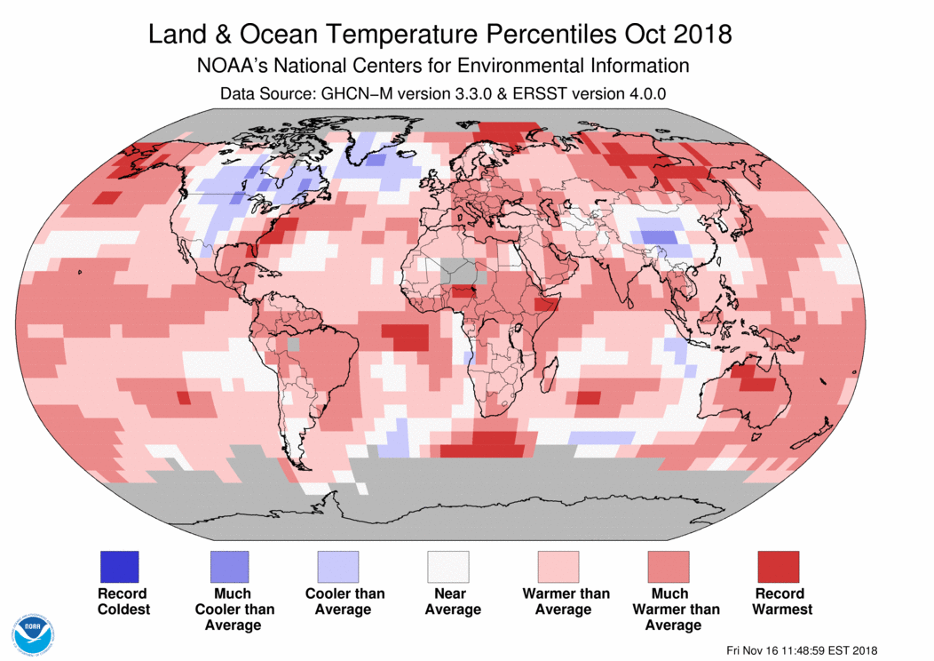
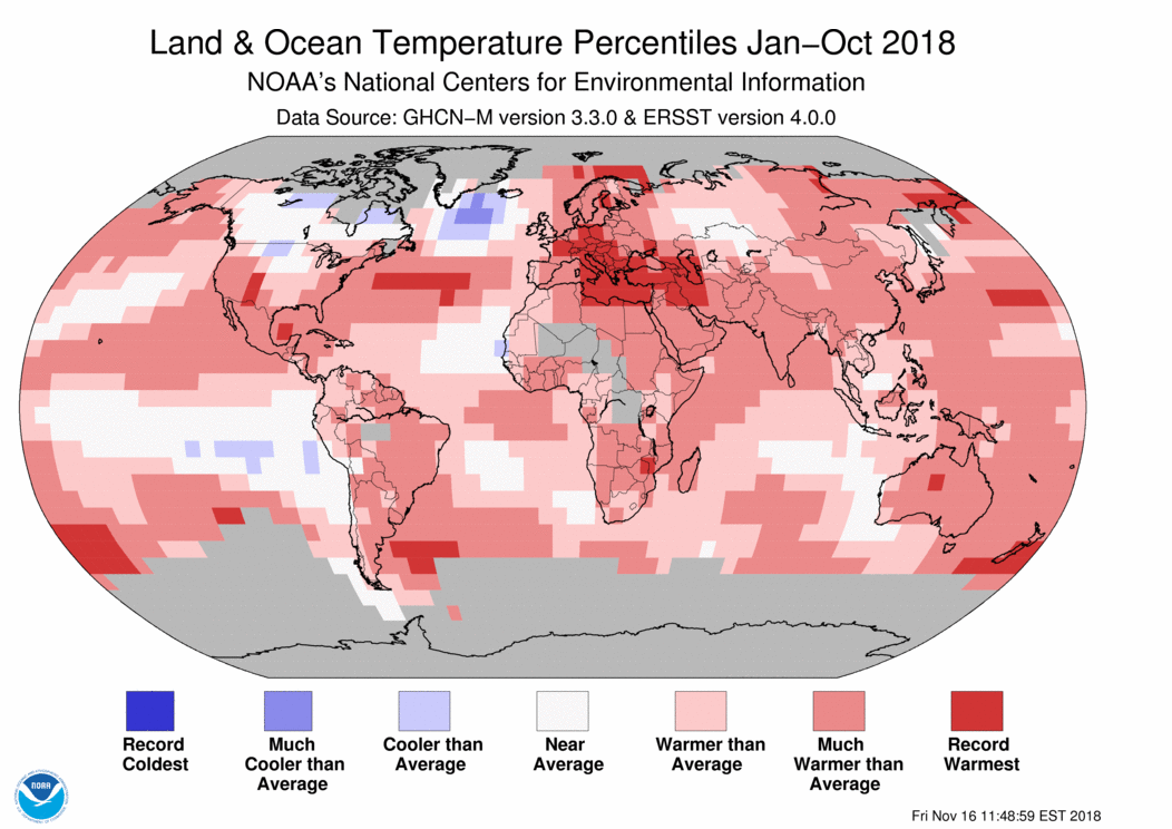
The long-term warming trend has continued in 2018, with the average global temperature set to be the fourth highest on record. The 20 warmest years on record have been in the past 22 years, with the top four in the past four years, according to the World Meteorological Organization (WMO).
Other tell-tale signs of climate change, including sea level rise, ocean heat and acidification and sea-ice and glacier melt continue, whilst extreme weather left a trail of devastation on all continents, according to the WMO provisional Statement on the State of the Climate in 2018. It includes details of impacts of climate change based on contributions from a wide range of United Nations partners.
The report shows that the global average temperature for the first ten months of the year was nearly 1°C above the pre-industrial baseline (1850-1900). This is based on five independently maintained global temperature data sets.
“We are not on track to meet climate change targets and rein in temperature increases,” said WMO Secretary-General Petteri Taalas. “Greenhouse gas concentrations are once again at record levels and if the current trend continues we may see temperature increases 3-5°C by the end of the century. If we exploit all known fossil fuel resources, the temperature rise will be considerably higher,” he said.
“It is worth repeating once again that we are the first generation to fully understand climate change and the last generation to be able to do something about it,” said Mr Taalas.
The Intergovernmental Panel on Climate Change (IPCC) special report on Global Warming of 1.5°C reported that the average global temperature for the decade 2006-2015 was 0.86°C above the pre-industrial baseline. The average increase above the same baseline for the most recent decade 2009-2018 was about 0.93°C and for the past five years, 2014-2018, was 1.04°C above the pre-industrial baseline.
“These are more than just numbers,” said WMO Deputy Secretary-General Elena Manaenkova.
“Every fraction of a degree of warming makes a difference to human health and access to food and fresh water, to the extinction of animals and plants, to the survival of coral reefs and marine life. It makes a difference to economic productivity, food security, and to the resilience of our infrastructure and cities. It makes a difference to the speed of glacier melt and water supplies, and the future of low-lying islands and coastal communities. Every extra bit matters,” said Ms Manaenkova.
The WMO report adds to the authoritative scientific evidence that will inform UN climate change negotiations from 2-14 December in Katowice, Poland. The key objective of the meeting is to adopt the implementation guidelines of the Paris Agreement on Climate Change, which aims to hold the global average temperature increase to as close as possible to 1.5°C.
The IPCC report on Global Warming of 1.5°C said that this target was physically possible but would require unprecedented changes in our lifestyle, energy and transport systems. It showed how keeping temperature increases below 2°C would reduce the risks to human well-being, ecosystems and sustainable development.
National meteorological and hydrological services have been contributing to national climate assessments. A new U.S. federal report detailed how climate change is affecting the environment, agriculture, energy, land and water resources, transportation, and human health and welfare, with a risk that it will lead to growing losses to American infrastructure and property and impede the rate of economic growth over this century.
A UK assessment published 26 November warned summer temperatures could be up to 5.4°C hotter and summer rainfall could decrease by up to 47% by 2070, and sea levels in London could rise by 1.15m by 2100. A Swiss report on climate scenarios released on 13 November said that Switzerland is becoming hotter and drier, but will also struggle with heavier rainfall in the future and its famed ski resorts will have less snow.
“The WMO community is enhancing the translation of science into services. This will support countries in generating national climate scenarios and predictions and developing tailored climate services to reduce risks associated with climate change and increasingly extreme weather. WMO is also working to develop integrated tools to monitor and manage greenhouse gas emissions and carbon sinks,” said WMO Chief Scientist and Research Director Pavel Kabat.
Highlights of the provisional statement on the state of the climate
Temperatures: 2018 started with a weak La Niña event, which continued until March. By October, however, sea-surface temperatures in the eastern Tropical Pacific were showing signs of a return to El Niño conditions, although the atmosphere as yet shows little response. If El Niño develops, 2019 is likely to be warmer than 2018.
Greenhouse gases: In 2017, carbon dioxide, methane and nitrous oxide concentrations reached new highs, according to WMO Greenhouse Gas Bulletin. Data from a number of locations, including Mauna Loa (Hawaii) and Cape Grim (Tasmania) indicate that they continued to increase in 2018.
Oceans: The oceans absorb more than 90% of the energy trapped by greenhouse gases and 25% of anthropogenic CO2 emissions, making them warmer and more acidic. For each 3-month period until September 2018, ocean heat content was the highest or second highest on record. Global Mean Sea Level from January to July 2018 was around 2 to 3 mm higher than the same period in 2017.
Sea ice: Arctic sea-ice extent was well below average throughout 2018 with record-low levels in the first two months of the year. The annual maximum occurred in mid-March and was the third lowest on record. The minimum extent in September was the 6th smallest on record, meaning that all 12 smallest September extents have been in the past 12 years. Antarctic sea-ice extent was also well below average throughout 2018. The annual minimum extent occurred in late February and was ranked as one of the two lowest extents.
Extreme Weather
Tropical Storms: The number of tropical cyclones was above average in all four Northern Hemisphere basins, with 70 reported by 20 November, compared to the long-term average of 53, leading to many casualties. The Northeast Pacific basin was especially active, with an Accumulated Cyclone Energy that was the highest since reliable satellite records began.
Two of the strongest tropical cyclones were Mangkhut, which impacted the Philippines, Hong Kong SAR and China, and Yutu, which brought devastation in the Mariana Islands. Jebi was the strongest typhoon to hit Japan since 1993, Son-Tinh caused flooding in Viet Nam and Laos, whilst Soulik contributed to flooding on the Korean peninsula. Hurricanes Florence and Michael were associated with huge economic damage and considerable loss of life in the United States. Gita, in the South Pacific, was the most intense and most expensive cyclone to ever hit Tonga.
Floods and rainfall: In August, the southwest Indian state of Kerala suffered the worst flooding since the 1920s, displacing more than 1.4 million people from their homes and affecting more than 5.4 million. Large parts of western Japan experienced destructive flooding in late June and early July, killing at least 230 people and destroying thousands of homes. Flooding affected many parts of east Africa in March and April. This included Kenya and Somalia, which had previously been suffering from severe drought, as well as Ethiopia and northern and central Tanzania. An intense low-pressure system in the Mediterranean Sea in late October brought flooding, high winds and loss of life.
Heatwaves and drought: Large parts of Europe experienced exceptional heat and drought through the late spring and summer of 2018, leading to wildfires in Scandinavia. In July and August, there were numerous record high temperatures north of the Arctic Circle, and record long runs of warm temperatures., including 25 consecutive days above 25 °C in Helsinki (Finland). Parts of Germany had a long spell of days above 30°C, whilst a heatwave in France was associated with a number of deaths. It was also an exceptionally warm and dry period in the United Kingdom and Ireland. A short but intense heatwave affected Spain and Portugal in early August.
Dry conditions were especially persistent in Germany, the Czech Republic, western Poland, the Netherlands, Belgium and parts of France. The Rhine approached record low flows by mid-October, seriously disrupting river transport.
Eastern Australia experienced significant drought during 2018, especially New South Wales and southern Queensland, with much of the region receiving less than half its average rainfall for the period from January to September. Severe drought affected Uruguay, and northern and central Argentina, in late 2017 and early 2018, leading to heavy agricultural losses.
Both Japan and the Republic of Korea saw new national heat records (41.1 °C and 41.0°C respectively.)
Oman reported one of the highest known minimum overnight temperature of 42.6 °C in June. Algeria saw a new national of 51.3 °C in July.
Cold and snow: One of the most significant cold outbreaks of recent years affected Europe in late February and early March.
Wildfires: Major wildfires affected Athens (Greece) on 23 July, with many fatalities. British Columbia in Canada broke its record for the most area burned in a fire season for the second successive year. California suffered devastating wildfires, with November’s Camp Fire being the deadliest fire in over a century for the U.S.A.
Other Impacts
The provisional statement contained details of impacts of climate change, based on contributions from the Food and Agriculture Organization (FAO), International Organization for Migration (IOM), UN Environment Programme (UNEP), UNESCO’s Intergovernmental Oceanographic Commission (IOC), UN High Commission for Refugees UNHCR) and World Food Programme (WFP). This section will be expanded in the final statement, to be released in March 2019.
Exposure of agriculture sectors to climate extremes is threatening to reverse gains made in ending malnutrition. New evidence shows a rise in world hunger after a prolonged decline. In 2017, the number of undernourished people was estimated to have increased to 821 million, according The State of Food Security and Nutrition in the World 2018, by to FAO, WFP, the International Fund for Agricultural Development, the UN Children’s Fund and the World Health Organization. Africa is the region where climate events had the biggest impact on acute food insecurity and malnutrition in 2017, affecting 59 million people in 24 countries and requiring urgent humanitarian action. Much of the vulnerability to climate variability is associated with the dryland farming and pastoral rangeland systems supporting 70–80% of the continent’s rural population.
Out of the 17.7 million Internally Displaced Persons tracked by the IOM, 2.3 million people were displaced due to disasters linked to weather and climate events as of September 2018. In Somalia, some 642 000 new internal displacements were recorded between January and July 2018 by UNHCR, with flooding the primary reason for displacement (43%), followed by drought (29%), and conflict (26%).
UN agencies including UNESCO-IOC and UNEP are tracking environmental impacts associated with climate change include coral bleaching, reduced levels of oxygen in the oceans, loss of “Blue Carbon” associated with coastal ecosystems such as mangroves and salt marshes. Climate change also exposes peatlands currently protected by permafrost to thawing and possible increased methane emissions and loss of carbon, and the associated sea-level rise increases the risks of coastal erosion and salination of freshwater peatlands.
Groundwater storage trends for Earth’s 37 largest aquifers from UCI-led study using NASA GRACE data (2003 – 2013). Of these, 21 have exceeded sustainability tipping points and are being depleted, with 13 considered significantly distressed, threatening regional water security and resilience. Credits: UC Irvine/NASA/JPL-Caltech
A recent NASA study was performed to track global freshwater trends from 2002 to 2016 by collecting from the NASA Gravity Recovery and Climate Experiment. James Famiglietti, of the NASA Jet Propulsion Laboratory in California, explained, “What we are witnessing is major hydrologic change. We see for the first time a very distinctive pattern of the wetland areas of the world getting wetter, in the high latitudes and the tropics, and the dry areas in between getting drier. Within the dry areas, we see multiple hotspots resulting from groundwater depletion.” One of the areas that has been most affected is Antarctica, where 10% of its glaciers are in retreat.
According to those involved with the study, there is “clear human fingerprint” on the global water cycle. NASA has a first-of-its-kind satellite, showing that over 30 parts of the globe show dramatic depletion of fresh water. “This report is a warning and an insight into a future threat. We need to ensure that investment in water keeps pace with industrialisation and farming. Governments need to get to grips with this,” said Jonathan Farr, a senior policy analyst at the charity WaterAid. Farr says, “We have been solving the problem of getting access to water resources since civilisation began. We know how to do it. We just need to manage it, and that has to be done at a local level.”
Both the climate crisis and human activity are the two main factors causing water scarcity today, calling upon greater action and better water management by humans before the issue gets worse.
Figure 25.1: Temperatures increased across almost all of the Southwest region from 1901 to 2016, with the greatest increases in southern California and western Colorado.23 This map shows the difference between 1986–2016 average temperature and 1901–1960 average temperature.23 Source: adapted from Vose et al. 2017.23. Map credit: The National Climate Assessment 2018
Aridity is the defining characteristic of the American West, and scientists reported Friday that the region is becoming even more arid due to human-caused climate change, putting states like Nevada at greater risk of water shortages, extreme wildfire, habitat loss and heat waves.
The National Climate Assessment, a 1,656-page report prepared by 13 federal agencies on Friday, painted a stark future in which prolonged droughts could create water insecurity in basins across the Southwest should policymakers not act to mitigate future climate change and adapt to changes already underway. In addition to causing disruption to everyday life, climate change in the Southwest is expected to affect industries like agriculture and ranching.
Nevada, the most mountainous state in the contiguous U.S. and the seventh largest state by area, straddles several ecosystems that would likely be harmed by hotter temperatures and changes to precipitation. Many of these early effects are already apparent, the report noted.
In the past two years alone, northeastern Nevada saw the state’s largest single fire while Southern Nevada saw an increase in heat-related deaths amid record-breaking summer temperatures.
“These are alarm bells that are going off right now,” said David Breshears, a University of Arizona ecologist and a report co-author, pointing to extreme wildfires and water shortages across the region.
The report cited dropping water levels at Lake Mead, the reservoir created by the Hoover Dam about 30 miles from Las Vegas, as a prime example of how climate change has affected regional water supplies. Lake Mead, the largest reservoir on the Colorado River system, stores water for millions of Americans and hundreds of farms downstream in Southern Nevada, California and Arizona.
Since the nearly two-decade drought began in 2000, the snowpack-fed reservoir has lost about 60 percent of its water because of overuse and arid conditions worsened by climate change. A paper released earlier this year showed that Colorado River streamflow has decreased by about 15 percent over the past 100 years with half of those decreases attributed to higher temperatures.
from the Grand Canyon News (Williams-Grand Canyon News):
With the 2019 Centennial celebration of Grand Canyon National Park on the horizon, Grand Canyon Conservancy (formerly Grand Canyon Association) and Grand Canyon National Park have announced a calendar of events for the year. Ranging from activities at the canyon to special presentations in cities throughout Arizona, the Centennial events have something for everyone.
“We’re excited to share this milestone celebration with the millions of people who love, care for, and visit the Grand Canyon each year. The Centennial is a time for reflection on the past and inspiration for the future. We honor those who have called Grand Canyon home for thousands of years while building towards a future that is inclusive and reflective of our nation,” said Christine Lehnertz, Superintendent of Grand Canyon National Park.
Events at the canyon include a Centennial celebration on February 26, 2019 (the actual Centennial date), a fun-filled Summerfest & Star Party on the South and North Rims in June, and other special performances and presentations throughout the year.
“We look forward to commemorating 100 years of the National Park Service at Grand Canyon, while inspiring future generations to experience, connect with, and protect the canyon’s unique resources,” said Susan Schroeder, Grand Canyon Conservancy CEO. “The Centennial events are a wonderful way to build awareness of the vital conservation, restoration, and education efforts supported by Grand Canyon Conservancy donors.”
Through September 2019 “Splendor & Spectacle: The 100-Year Journey of Grand Canyon National Park” exhibition at NAU Cline Library, Flagstaff.
January 11 – 12 “Grand Canyon Suite” performances by the Phoenix Symphony
January 15 Martin Luther King, Jr. National fee-free day at Grand Canyon
February 20 – 24 Grand Canyon Historical Society Symposium at Shrine of the Ages
February 22 Community Centennial Celebration in Tusayan
February 23 “Teddy Roosevelt: The Man in the Arena” performance at Shrine of the Ages auditorium
February 26 Founder’s Day Centennial Celebration at the South Rim Visitor Center
March 1 “Mapping Grand Canyon” conference at ASU in Tempe.
March 2 – 3 “Grand Canyon State” performances by the Tucson Symphony
April 9 Grand Canyon Storytellers event in Phoenix
April 16 Naturalization Ceremony at Mather Amphitheatre
April 20 National Park Week fee-free day
May 10 Railroad Day/Transcontinental Sesquicentennial
May 17 – 19 Grand Gathering: Grand Canyon Conservancy supporters’ weekend
May 18 Pete McBride presentation: “Grand Canyon: Between River and Rim” at Shrine of the Ages
May 19 Powell Memorial plaque dedication
May 24 – 25 Wildlife Days
June 22 Junior Ranger Day
June 22 – 29 Centennial Summerfest and Star Party
Through July “Echoes from the Canyon” living history exhibit
July 4 Independence Day Parades – Flagstaff and Tusayan
Through August American Indian Heritage Days
Through September Hispanic Heritage Month
September 7 – 15 Celebration of Art
September 28 Public Lands fee-free day
September 28 Naturalization Ceremony
November 9 – 10 Native American Heritage Month celebration
November 11 Veterans’ fee-free day
November 28 Community Holiday Open House at Visitor Center Plaza
The lower Colorado River. Photo: Brent Gardner-Smith/Aspen Journalism
One efficient and effective form of collaboration on the Colorado River, in the Grand Canyon. Photo: Brent Gardner-Smith/Aspen Journalism.
The U.S. Whitewater Rafting Team trains on its custom-built raft in December on the Colorado River. The team was on pace for a record descent of the 277-mile canyon [January 14-15, 2017] when a wave broke the frame and punctured a tube. Photo Special to The Denver Post by Forest Woodward.
Peter McBride at the oars and camera Grand Canyon June 2015
The confluence of Havasu Creek with the Colorado River (river mile 157) is a popular place for boaters to stop and admire the striking blue-green water of Havasu Creek. The turquoise color is caused by water with a high mineral content. At the point where the blue creek meets the turbid colorado river there often appears a definite break. NPS photo by Erin Whittaker.
Crystal Rapid via HPS.com
Fog-filled Grand Canyon
Fog-filled Grand Canyon
Brighty the pancake-loving donkey: Bobby McKee rides his trusty partner, Brighty, while fetching water for residents at the Wylie Way camp in the Grand Canyon in 1918. (Photo courtesy of Marth Krueger)
Grand Canyon sunset April 22, 2013 via the NPS
Via the USGS
Grand Canyon from Grandview Point January 24, 2009 via the National Park Service
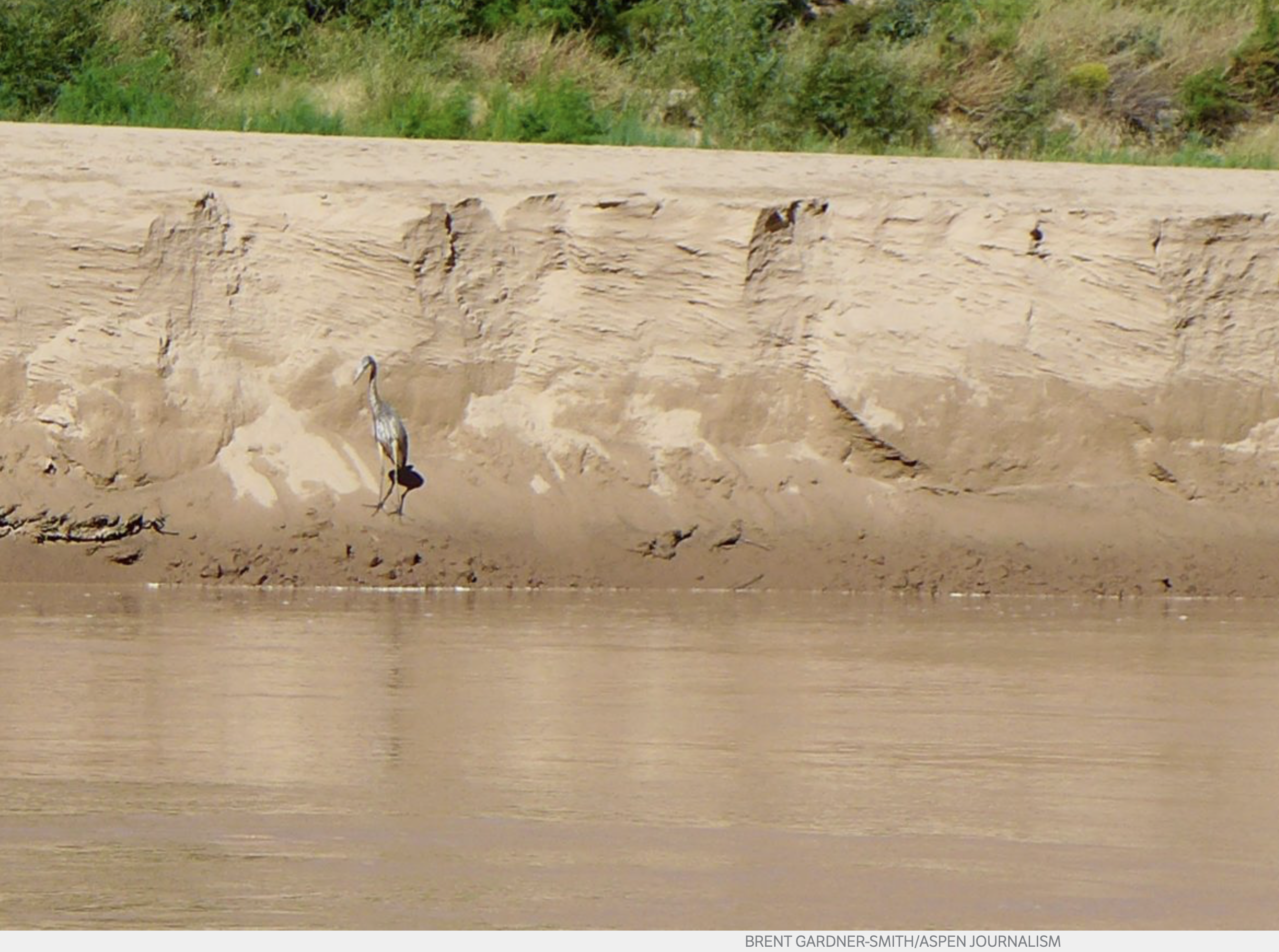
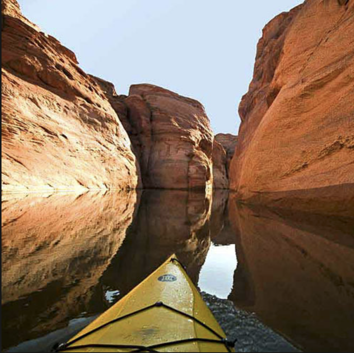
A heron on a big sandbank in upper Lake Powell, above Hite. As the big reservoir recedes due to almost 20 years of drought in the Colorado River basin, new sights are emerging. A regional effort to send more water into Lake Powell in a new regulatory pool of water is gaining momentum in anticipation of a regional water meeting in mid-December in Las Vegas. Photo credit: Aspen Journalism/Brent Gardner-Smith
The directors of the Colorado River Water Conservation District voted Monday to endorse a new state policy regarding “drought contingency planning” designed to bolster water levels in Lake Powell and Lake Mead, with the larger goal of avoiding violating the Colorado River Compact.
The support of the River District board, which represents 15 Western Slope counties, was expected. The district’s general manager, Andy Mueller, spoke in favor of the policy before the CWCB directors unanimously voted to approve it Nov. 15 at a meeting in Golden.
Expected or not, the support by the River District board was seen a key step in the fast-moving effort to get the four states in the upper Colorado River basin, Colorado, Utah, Wyoming and New Mexico, and the three states in the lower river basin, California, Arizona and Nevada, to keep working together on a plan to keep the two biggest reservoirs on the river system functioning as intended.
Lake Powell today is 43 percent full. The giant reservoir formed by Glen Canyon Dam typically receives 10.3 million acre-feet of water flowing into it from the Colorado, Green and San Juan rivers each year. But annual inflows have been less than 5 million acre-feet for seven of the past 18 years, and have been below average for 15 of the past 18 years, according to a summary of recent water meeting at Colorado Mesa University prepared by Ken Ransford, the secretary of the Colorado River Basin Roundtable.
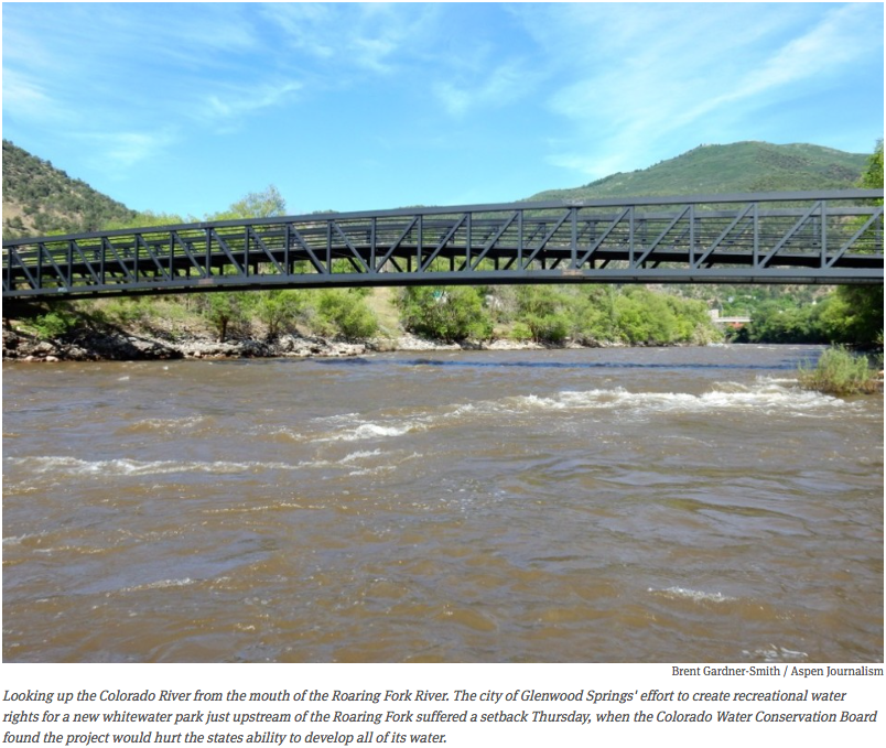
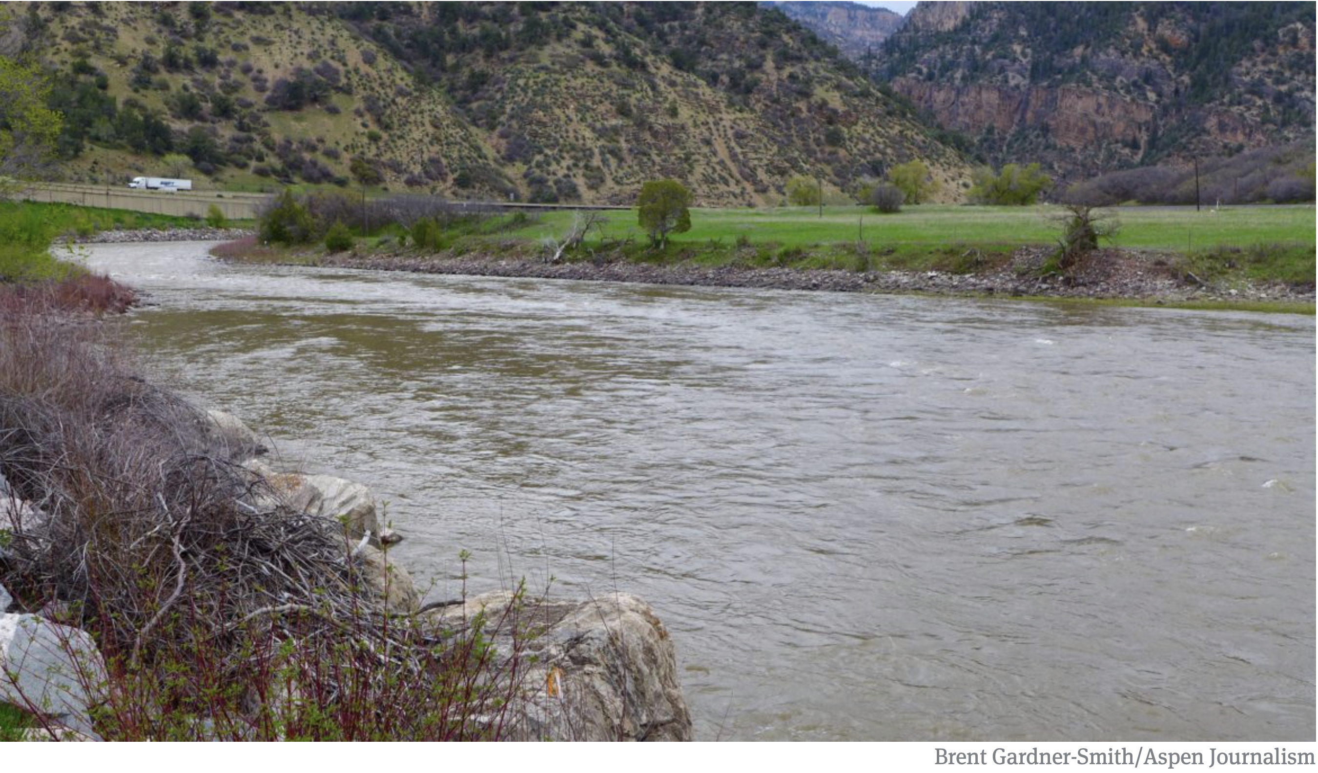
Water from the Roaring Fork, Fryingpan and Crystal rivers flows into the Colorado River in Glenwood Springs.
Water managers say three more dry years could leave the reservoir too low to make hydropower at the dam, and then if drought continues, too low to release enough water to meet the upper basin’s obligations to the lower basin, which could trigger a compact call.
The timing of the River District’s vote Monday was also important, as the seven basin states are working to gain basin-wide consensus on a series of related drought contingency agreements by the annual meeting of the Colorado River Water Users Association in Las Vegas from Dec. 12 to 14.
And if the River District had not endorsed the state’s new policy, it could have signaled discord on the plans between Colorado’s Western Slope and Front Range.
“We recognize that these policies are far from perfect. We do, however, believe that they represent a good-faith effort by the CWCB at demonstrating leadership and a commitment to many of the policies adopted by our board,” Mueller said in a Nov. 23 memo to the district’s board of directors.
The new Colorado policy, which has now been endorsed by the River District, voices the state’s support for setting up a regulated pool of water in Lake Powell designed to boost reservoir levels.
That pool of water — a tiny bucket within a very big bucket — is to be filled through a voluntary, temporary and compensated demand management, or water-use reduction, program that has yet to be set up across the upper basin states.
Colorado’s new policy also says if the voluntary program does not send enough water to the new pool in Lake Powell, and a mandatory curtail program is necessary to avoid a compact call, that such a mandatory program be set up only after a public process.
The policy also says that the voluntary program will be designed to cut back on water use on both sides of the Continental Divide so as to minimize economic hardship being focused on just one part of the state.
“One of the primary areas of concern for the West Slope conservation districts is that any demand management program not have disproportionate impacts on the West Slope and that water contributed to such a program be produced in rough proportion to the post compact depletions to the Colorado River system from both sides of the continental divide,” wrote Mueller in his Nov. 23 memo.
Marti Whitmore, who represents Ouray County on the River District board, put that concern in plain terms Monday: “I want the Front Range to actually have to turn off the spigot, so to speak.”
A raft coming out of Cataract Canyon into upper Lake Powell encounters the bathtub ring left by the receding reservoir. As Lake Powell, and Lake Mead, continue to see less and less water, it’s prompting water managers, including those at the Colorado River District, to coordinate on ways to send more water downstream. Photo credit: Aspen Journalism/Brent Gardner-Smith
Soft on prior appropriation?
The River District’s endorsement of the new state policy was not without some contention, including issues raised by Glenn Porzak, the water attorney for the Eagle River Water and Sanitation District and the Upper Eagle Regional Water Authority, which together provide water for 65,000 users in the Vail and Eagle County region.
Porzak had concerns about whether the state policy represented a retreat from the prior appropriation doctrine in Colorado, which is summed up by the phrase “first in time, first in right.”
In his letter, Porzak said language in the new state policy about potential future compact administration “is an obvious effort to protect transmountain diverters with junior water rights and should be alarming to all senior West Slope water managers, owners and organizations charged with protecting those rights.”
Porzak also questioned whether the CWCB would advocate in the future for strict adherence to the prior appropriation system, where junior water rights are cut off before senior rights, and especially water rights in use before the 1922 Colorado River Compact was signed.
“The lack of commitment to the state’s constitution and laws demonstrates its intent to deviate from them should a compact call occur,” Porzak said in his letter.
The River District board discussed Porzak’s concerns and then ended up taking three votes on carefully worded motions, all of which passed.
The first vote was to formalize the River District’s support for the regional drought contingency planning efforts and the setting up a voluntary demand management program in Colorado and the other upper basin states.
That motion also said “the River District will continue to advocate on behalf of West Slope water uses in future discussions concerning a demand management program.”
The second vote was to voice the district’s support for a public process in the event that a mandatory effort was needed.
And in response to Porzak’s concerns, that motion also said the River District will only support curtailment policies or actions that are consistent with the district’s own policies regarding the Colorado River Compact.
The River District’s policy, last updated in July, recognizes that some flexibility in how the prior appropriation system is administered may be needed in the future, given the complexity of actually curtailing water rights across four Western Slope river basins based strictly on their priority date.
The third vote taken Monday by the River District board was to support, in concept, the short piece of federal legislation that is soon to be introduced and is required to allow the drought contingency planning efforts to take effect.
Editor’s note: Aspen Journalism covers water and rivers in collaboration with The Aspen Times and other Swift Communications newspapers. The Times published this story on Tuesday, Nov. 28, 2018.
Colorado transmountain diversions via the State Engineer’s office
State Engineer, Pat Tyrrell has advised Governor Matt Mead of his plan to retire in early January 2019. The State Engineer, serving as the chief water official in the state, is a position established in the Wyoming Constitution – a unique designation signaling historic importance of water to the State. Tyrrell has been the State Engineer since January, 2001.
“Pat Tyrrell has served in this role with distinction,” Governor Mead said. “He is recognized throughout the state, region and nation as an expert on all matter relating to water resources. Pat has a reputation for balance. He has held the title of State Engineer in the Administrations of four Wyoming Governors.”
Tyrrell is planning on serving Governor-elect Gordon through the upcoming 2019 General Legislative Session, and will leave office shortly thereafter.
The Wyoming State Engineer’s duties range from overseeing the permitting and adjudication of water rights, regulation of the use of water under the doctrine of prior appropriation, and representing the state on numerous interstate compact commissions. The State Engineer also represents Wyoming on the North Platte Decree Committee, the Western States Water Council, and the Colorado River Salinity Control Forum, among other groups. It is a cabinet-level position.
Since 1890, Wyoming has had only 16 State Engineers. Technical in nature, the position has a constitutional term of six years, intended to overlap Gubernatorial terms and minimize political influences in the performance of the job. By the time of his retirement, Tyrrell will have served under four Wyoming Governors.
According to Tyrrell, “I’ve been honored to serve as Wyoming State Engineer. This is my home state, and I’m an outdoors guy. What better way to give back to a state you love than holding such a noble position focused on such an important natural resource? I’ve been lucky to serve as long as I have, and it’s been enormously rewarding. I’m very appreciative that every governor I served was supportive of our mission and helped with resources and decisions so we could perform at our best. And I have been blessed all these years to serve alongside wonderful, dedicated public servants in the State Engineer’s Office”
During his tenure, Tyrrell has dealt with successful compliance with the 2001 Modified North Platte Decree, the Coalbed Natural Gas boom, numerous Colorado River agreements, and served through the entirety of the 11-year United States Supreme Court lawsuit with Montana involving the Yellowstone River Compact. He also was responsible for entering two groundwater orders, one near LaGrange Wyoming and one in central and eastern Laramie County, intended to replace longstanding local disputes with predictable groundwater management policies and long-term groundwater resource protection.
“Previous State Engineers had wrestled with these problems, but they didn’t go away,” Tyrrell said. “I didn’t see how we could let them go on festering. In the end I think we struck a balance and made the most equitable decisions we could, for all involved.”
Tyrrell grew up in Cheyenne, and graduated with a B.S. in Mechanical Engineering and M.S. in Civil Engineering, both from the University of Wyoming. In 2016 he was selected as the Wyoming Eminent Engineer by the Tau Beta Pi Engineering Honor Society at UW, and in the fall of 2018 he and his wife Barbara endowed the Patrick and Barbara Tyrrell Engineering Scholarship, also at UW.
The sediment study will begin this month to collect historical and recent data on metal concentrations.
The Utah Department of Environmental Quality, the U.S. Geological Society, the National Park Service and the U.S. Bureau of Reclamation are all part of the collaborative effort.
According to the agencies, the monthlong project will extract cylindrical, long-core samples at multiple locations along the river deltas entering Lake Powell.
Scientists say the cores should reveal how flash floods, historic mining in the Upper Animas River, mine remediation activities, and spring runoff affects the timing, mass and concentration of metals deposited into the lake.
“This study will help us understand whether human activities such as mining in the San Juan River watershed have impacted or pose a risk to the important recreational, aquatic life, and cultural resources of the San Juan River and Lake Powell,” said Erica Gaddis, director of the Utah Division of Water Quality. “This project is a great example of applying science to inform water resources management.”
The survey will assess the concentration and distribution of metals at Lake Powell, including arsenic, cadmium, copper, mercury and lead.
Concentrations could affect water quality, human health and aquatic life, especially as drought continues to drag down the level of the lake. The lake is a critical component of a system that provides drinking water to 40 million people in the Southwest.
“This is the first study to collect and characterize sediment through the full thickness of the San Juan and Colorado river deltas,” said Scott Hynek, a scientists with the U.S. Geological Survey. “Drilling long cores of sediment will allow USGS scientists to analyze metal concentrations from before the Glen Canyon Dam was constructed through the present day.”
Risks of above-ground power lines & the cost of going underground
California’s Camp and Woolsey fires put the electrical infrastructure upon which all mountain communities depend into vivid focus. A central question has been what value should be assigned to the benefits of putting transmission and other electrical lines underground.
Investigators had still not determined by Monday what caused the two fires. However, The Guardian reported on Saturday that the California Public Utilities Commission said it received reports from two utilities showing equipment issues occurred in areas close to where the fires ignited in the moments before flames began to spread.
On Monday, the Sacramento Bee reported that Pacific Gas & Electric had informed the PUC of a high-voltage outage in an area just a few minutes prior to the first reports of flames that quickly became the Camp Fire. The Guardian on Saturday said a utility had also reported problems about the time the fire near Los Angeles erupted and in the same vicinity.
A spokeswoman for the Utility Reform Network, a California advocacy group, pointed to a record of problems. “We don’t know yet if PG&E (Pacific Gas & Electric) is responsible for the Camp Fire,” Mindy Spatt told The Guardian. “But we know there is a pattern there, and it is a pattern that is costing consumers potentially billions of dollars (in liability payouts) and costing lives as well.”
Several mountain towns in the Rockies have been talking about alternative delivery of electricity to improve resilience. Cost of putting lines underground has been part of the discussion.
The proposed line in the Vail area would be of the size in the third from the left.
In the Vail area, Holy Cross Energy proposes a new 115-kilovolt transmission line between a substation at Gilman, a now-abandoned mining town, and Avon, at the foot of Beaver Creek. The new transmission line would make the communities along Interstate 70 in what is commonly called the Vail Valley less vulnerable to risk of wildfire, equipment failure, or even sabotage.
Holy Cross has been working on creating that redundancy for two years, but the risk of wildfire was highlighted in July when a small fire temporarily threatened the main power lines along I-70. In response, the local water district ordered a ban on all outdoor watering. Without electricity, it has enough water to last for only a couple of days.
Just days before, a far bigger fire had threatened to put Aspen and Snowmass in the dark for the July Fourth weekend. The Lake Christine Fire that was started on July 3 by target shooters at a range near Basalt burned three of four power lines used by Holy Cross Energy to Aspen. The fire was about 20 miles down valley from Aspen. Had the fourth and final line gone down, Aspen would have been without power for several days. Repair crews cannot go into a fire area until it has been fully contained.
A backup transmission line to Telluride was put underground for 10 miles as it crossed Wilson Mesa, an area of unusually high-value and calendar-worthy real estate. Photo/Realtor.com
The two fires illustrate just how vulnerable mountain resort towns can be, due to their often tortured if wondrously scenic geography. Telluride illustrates the vulnerabilities even better.
Twice in this century Telluride has lost power during ski season when transmission lines were damaged. The primary transmission line comes from the south, over Ophir Pass. In 2004 a snow slide took out one of those transmission lines. Telluride and Mountain Village, including the ski area, had three days of reduced power and rolling blackouts during the height of ski season.
In response, a new 51-mile backup power line was completed in 2013. The $56 million line comes from the west, in the Nucla area. The negotiations were protracted, involved lengthy hearings before the Colorado Public Utilities Commission, and a court case. The primary issue was the cost of undergrounding a 10-mile segment through calendar-worthy Wilson and Specie mesas. Some of the most expensive real estate in the Telluride area is located there.
The $19 million cost of undergrounding was paid in part by homeowners of the high-priced homes on the mesas but also the two towns, San Miguel County, and both the wholesale provider, Tri-State Generation & Transmission, and the distribution co-operative, San Miguel Power. Customers of the co-op are being charged via a surcharge over a 30-year period.
Art Goodtimes, then a San Miguel County commissioner, believes that undergrounding should be considered in the context of avoided cost. Underground lines pose less risk of causing wildfires. “If you’re really serious about (mitigating) wildfire risk, undergrounding makes sense if you consider the avoided costs, the dollars and cents, of containing wildfires,” he says.
Even so, Telluride, however, still did not have full redundancy. On Presidents’ Day Weekend in 2017 a refrigerator-sized boulder tumbled 800 feet and struck a power line pole. A comedy festival at the Sheridan Opera House in Telluride had to be finished in candlelight and a local grocery unloaded frozen goods at a discount.
That last-mile redundancy has since been addressed by the local San Miguel Power Association.
Holy Cross Energy has said it would put 1.7 miles of transmission line underground in Minturn, which is much but not all of the town. Photo credit: Allen Best
Underground lines always cost more. A May story in The Atlantic cited a 2012 study by the Edison Electric Institute that found underground lines had fewer problems during storms and were better for public safety all around. But the cost, said the article, starts at $1 million a mile. In mountainous areas, it’s much higher yet. Even the lower figure is 5 to 10 times what it costs to hang a line overhead.
This added cost can make undergrounding prohibitively expensive. The magazine cited a plan in North Carolina to put lines underground that was dropped. It would have caused electrical rates to rise 125 percent.
In Minturn, Holy Cross has indicated willingness to bury 1.7 miles of the 8.65-mile line. That would put it out of sight in most of Minturn, but not all. Minturn wants more undergrounding.
“Certainly Minturn wants to support redundancy in the system. We get it. We just love the idea of undergrounding for a variety of reasons,” says Michelle Metteer, the town manager.
There’s also the question of equity. Holy Cross has buried distribution lines in Snowmass Village, as was pointed out by Minturn resident Lynn Feiger in an op/ed published in the Vail Daily during September. Why, she seemed to ask, would it treat the Minturn area any differently?
As for Aspen, Holy Cross has been talking about distributed generation coupled with battery storage as one option for making the community’s electricity supply less vulnerable to wildland fires.
In Idaho, a similar discussion is under way. There, the path for a second transmission line to the Ketchum-Sun Valley area has been identified but not the details. Undergrounding is among the options, but at an additional cost that Idaho Power estimates at $34.5 million. The Idaho Mountain Express reports several financing options, none of them inviting or easy.
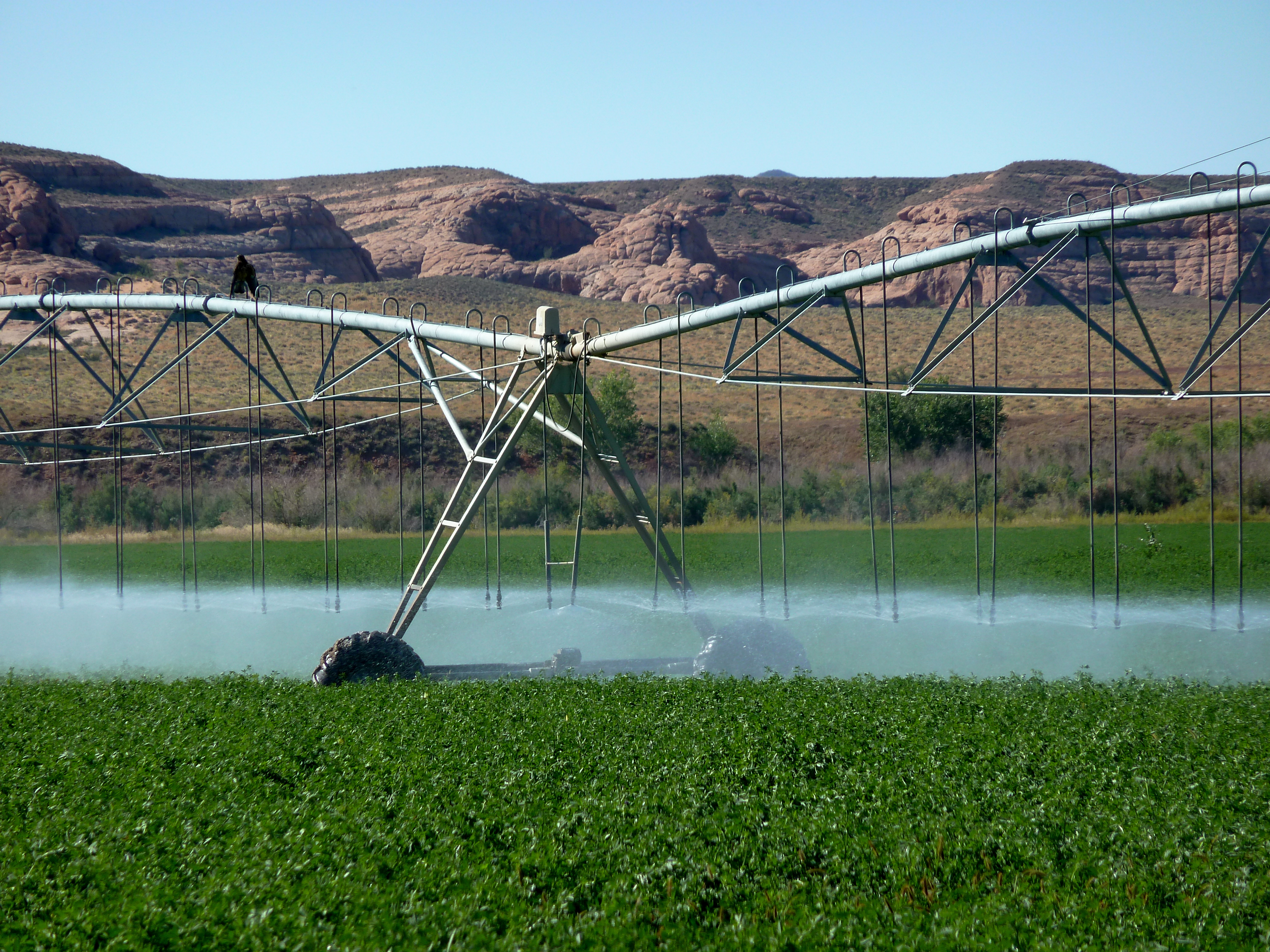
Irrigation sprinklers run over a farm in Longmont in the South Platte River basin. One goal of an emerging storage project on the South Platte is make it easier to temporarily use water from agriculture to meet the growing needs of the Front Range metro area. Photo credit: Lindsay Fendt/Aspen Journalism
Every year, an average of 142 billion gallons (436,000 acre-feet) of water slips down the South Platte River out of Colorado and into Nebraska. Right now, that water feeds into habitats of endangered fish and birds, but most of it could legally be diverted and used in Colorado instead.
For decades, these escaping river flows — sometimes millions of acre feet of water more than Colorado is required to deliver to Nebraska — have been seen as a loss by Front Range water managers, but the hefty price tag of infrastructure to divert, store and move water has kept new projects from getting off the ground. Now, with communities struggling to bolster their supplies to feed the Denver metro area’s exploding population, a group in the South Platte basin thinks it can develop a regional plan to tap the river’s potential.
The infrastructure concept could provide a large chunk of the Front Range’s projected future water needs, and the concept’s designers say, if executed properly, the project would keep agricultural communities intact and create environmental benefits. Skeptics say it’s a costly plan that would further drain an already beleaguered river system.
Constructing it would require billions of dollars and an unprecedented amount of cooperation among water users, but in today’s era of scarcity, Some water managers say it may be the simplest path forward.
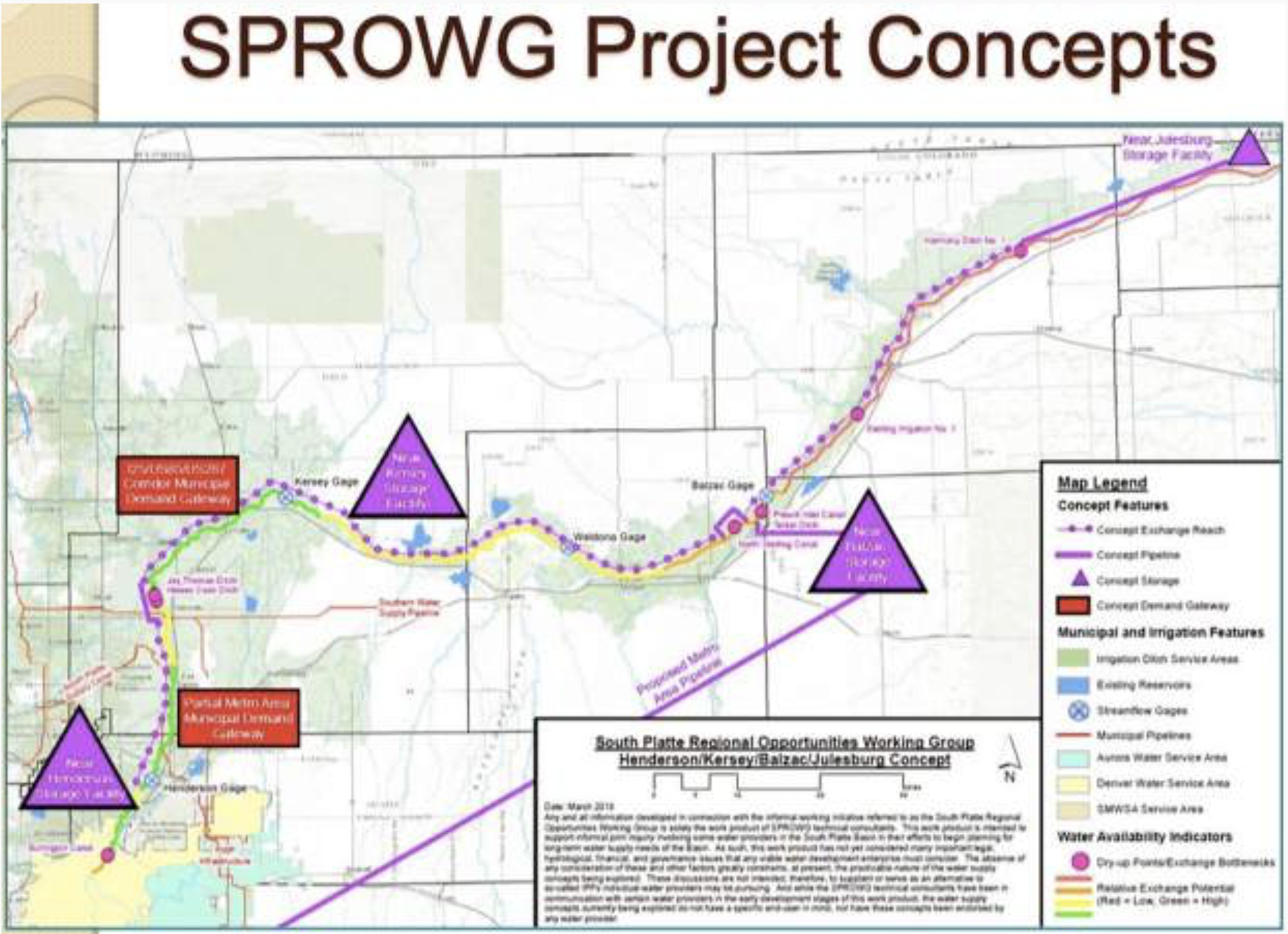
A group called the South Platte Regional Opportunities Working Group, or SPROWG, is proposing to store 175,000 acre-feet of water in a series of reservoirs on the South Platte River, from north of Denver to the Morgan County line. The project also includes a long pipeline to pump water from the river back to the metro area to be cleaned and re-used. Graphic credit: CWCB via Aspen Journalism
Birth of the South Platte Regional Water Development Concept
Despite the amount of Colorado water headed into Nebraska, water from the South Platte is still used on a huge scale. Diversion ditches from the river feed cities, agriculture and industry along the Front Range, including farms in Weld County east of Greeley, but not all the water applied to the land is consumed — about 50 percent of the water from flood irrigation seeps back into the river.
Legally, these return flows can be reused downstream, but they aren’t always released back to the river in areas where they can be captured. And because much of the water is wastewater, its quality is often too low to be used as drinking water.
These complications have made South Platte water an undesirable option for many municipalities, and growing cities have, instead, turned to water from the other side of the Continental Divide. This water is cleaner, less expensive due to existing infrastructure and can legally be used for any type of use without going through water court. But the use of Western Slope water on the Front Range has long drawn criticism from water officials on the other side of the mountains: They see such use as overuse of their resources.
The under appreciation for South Platte water started to change in 2010, after the state released the Statewide Water Supply Initiative, a data analysis of Colorado’s water supplies and projected future demand. The study estimated that by 2050 Colorado would need between 310,000 and 560,000 more acre-feet of water than it can currently supply. About 50 to 60 percent of this water would be needed within the South Platte Basin, the fastest-growing part of the state. This anticipated supply gap forced Front Range water providers to consider new options.
“We knew there was a looming problem out there. The South Platte has a big issue coming for it with this huge-growing population,” said Joe Frank, the general manager for the Sterling-based Lower South Platte Water Conservancy District. “The two biggest sources being looked at were the dry-up of South Platte irrigated agriculture or to use more (Western) Slope water — and we knew that both of those had issues.”
Around that time, Frank and six other water experts started holding informal meetings to discuss South Platte water supplies. The group became known as the South Platte Regional Opportunities Working Group. About the same time that group was meeting, the Colorado legislature also grew interested in the river.
In 2016, the General Assembly ordered a study to determine how much Colorado water was entering Nebraska and to analyze possible water-storage projects to capture that flow. This South Platte Storage Study found that over a 20-year period, Colorado delivered nearly 8 million acre-feet of excess water to Nebraska. But while there was plenty of water available in the river, accessing it would be costly or environmentally damaging.
The group took that information and — using funds from water providers such as Denver Water, Northern Water and Aurora Water — commissioned its own consultants. The group’s findings became known as the South Platte Regional Water Development Concept, and outlined a possible plan for a water system on the river. The current proposal includes three new storage facilities — near Henderson, Kersey and Balzac — and a pipeline from the Balzac facility to the metro Denver area. The concept’s designers say it could consistently provide 50,000 acre-feet of water every year.
With a concept in hand, the group expanded into a task force, drawing about 40 volunteer members with varying interests in water. The task force is now using $390,000 in grant funding from the Colorado Conservation Board and the South Platte and Metro basin roundtables to hire consultants to analyze the project idea.
Water for cities with no ‘buy and dry’
Although much of the water that could fill the concept plan would be unappropriated return flows, some of it would probably need to come from agriculture. In the past, this was done by cities that purchased farms with senior water rights and fallowed the lands. If done on a large scale, the practice, known as “buy and dry,” can eliminate agricultural communities.
Rather than promote buy-and-dry, the creators of the concept plan want to use alternative transfer methods to buy temporary water leases from farmers on an annual or seasonal basis. These agreements allow farmers to get money for their water without permanently drying up their farm. While alternative transfer methods are considered better for farmers, executing the agreements on a large scale requires infrastructure to move the water around.
“With ATMs, you are going to need to move that water from the farm to the city,” said Todd Doherty, the founder of Western Water Partnerships, a group that facilitates alternative transfers. “The geography is such on the South Platte that the farms are downstream from the city, so infrastructure is almost absolutely necessary to move ATM water back upstream.”
With three storage facilities near farmlands and a pipeline running to the Denver area, the South Platte concept could be used to facilitate alternative transfer methods.
“I think farmers should have options and municipalities should have options,” said Jim Yahn, the manager of the North Sterling Irrigation District and an original member of SPROWG. “This project has infrastructure to get seasonal water from agriculture and turn it into a year-round supply for a municipality.”
The South Platte River runs by a utility plant near I-25 in Denver. A group of Front Range water providers are working on a plan that includes up to 175,000 acre-feet of new water storage along the river.
Environmental concerns
Because the concept plan is still in its early phases of development, most environmental groups have yet to release an opinion on the project. Still, there are concerns about depleting the flows of the South Platte or further degrading its waters.
In hopes of reducing impacts, some environmental representatives have joined the concept plan task force to provide feedback. Frank said the promise of mitigation and environmental enhancements – improvements on the river made by water providers – have gotten several environmental groups “on board” with the project’s idea.
Still, other groups say the projected supply-demand gap is overblown and any new infrastructure is an unnecessary drain on the state’s rivers…
Hefty price tag
As projected in the South Platte Storage Study, the costs to build the project would be huge. Although the project doesn’t yet carry a final price tag, initial estimates put the infrastructure costs at nearly $2.5 billion.
This cost is undeniably high, but with water becoming a more expensive commodity, water providers say it’s an increasingly reasonable one to consider. The cost estimates show that water from the concept plan would cost about the same as building any other water project or buying into an existing one.
For these reasons, many water providers in the Front Range are already exploring how they fit into the regional project.
“Scarcity is essential in driving the municipal world towards more expensive solutions,” said Sean Chambers, the director of water and sewers for the city of Greeley. “We haven’t coalesced around an idea about how exactly we fit into the long-range vision, but we know we belong at the table.”
Editor’s note: Aspen Journalism covers rivers and water in collaboration with The Greeley Tribune and other Swift Communications newspapers. The Tribune published this story on Saturday, Nov. 26,2018.
In 1982, the Army Corps of Engineers released the Plains Ogallala Aquifer Regional Resources Study, which detailed for the first time (in any official capacity) the cost and opportunity related to the construction of a 360-mile concrete aqueduct beginning at the Missouri River in the Northeastern part of Kansas and ending in Utica – traveling nearly three-quarters of the way across the state. This aqueduct would deliver approximately 3.4 million acre-ft (AF) of water annually (1 acre-ft = 325,851 gallons) to parched farmers and communities. In turn, the canal would require 15 pumping stations in order to rise nearly 1,750 ft in altitude to reach its ultimate, Utica reservoir.
The cost? $18 billion up-front with an estimated $1 billion in annual ongoing expenses ($400 million in operational costs and $600 million in interest).
The costs are exorbitant – resulting in a $470/AF price of new water for farmers who, according to a 2013 report by the US Department of Agriculture, currently pay approximately $47/AF for off-farm purchased water. Can an agricultural industry with shrinking margins due to increased competition and international trade tariffs handle a 10x increase in water prices?
And yet, there remains something romantic about the Great Kansas Aqueduct. Arizona has its 336-mile Central Arizona Project; California has its 701-mile State Water Project; why shouldn’t Kansas have its Great Kansas Aqueduct? After all, as the Kansas Aqueduct Coalition has stated, “With sedimentation reducing water storage in the East, and the Ogallala being rapidly depleted in the West, Kansas stands to lose more than 37 percent of its water in 50 counties across the state by 2062, or an annual shortfall of 1.86 million acre-feet.”
Thirty-six years after this project was first conceived in full, though, shovels and backhoes remain in their sheds as the Ogallala aquifer drops nearly two feet per year in some counties due to groundwater over pumping. If groundwater withdrawals continue at current rates, most of southwest Kansas will exhaust its water reserves within 25 to 50 years. One tends to think that in times of yesteryear, individuals would have begun construction on this project in February of 1982, begging for forgiveness later. But the time of unbridled infrastructure construction has passed and Kansas continues to stress its water resources.
As one sits and considers the need for the Great Kansas Aqueduct, three questions come to mind: 1) does the Great Kansas Aqueduct solve a problem? Yes – it would increase water supplies for Western Kansas. 2) would it solve the problem for generations? Yes – it would likely be operational for decades. And 3) would it be cost-effective? Unfortunately, not. While the volume of water delivered to Western Kansas may increase, very few people would actually be able to afford it. In fact, the $18 billion estimated to build the Great Kansas Aqueduct does not even include the legal, economic, and ethical costs inherent to initiating eminent domain and forcibly removing people in the way of the canal off of their land.
U.S. Fish and Wildlife Service biologists counted 50 yearling razorbacks during a recent survey in the upper Colorado River Basin — the result of water releases in 2016 and 2017 from the Navajo Reservoir aimed at helping the fish, agency officials said this week.
Federal operators of the reservoir let out 5,000 cubic feet of water per second for 50 days, more than doubling regular flows in the San Juan River. This increased flow created nursery pools, the habitat razorbacks and three other endangered native fish need to spawn and survive.
Saving razorbacks and other fish “is going to be totally dependent ” on putting more water into rivers, said Tom Chart, director of the Upper Colorado River Endangered Fish Recovery Program, a 25-year, $360 million government-run rescue effort.
“We’re not going to be able to restore the natural hydrological conditions. We understand that,” Chart said. “But we can recreate conditions that help young fish much more regularly.”
Yet the intensifying climate shift toward heat and aridity in Southwestern states, combined with population growth, constrains biologists’ push to put more water into rivers for environmental purposes. No water could be released this year from the Navajo Reservoir, which straddles Colorado and New Mexico and holds 1.7 million acre-feet, Bureau of Reclamation engineer Susan Behery said. Probably none will be spared next year, either, because water managers are prioritizing storage after a near-record low snow year left the reservoir half full.
Raising, stocking razorbacks
For more than 30 years, federal biologists responsible for emergency rescues of endangered species have relied on raising razorbacks in hatcheries and copiously stocking them into Colorado River tributaries. Razorbacks evolved in wild free-flowing rivers, enduring for millions of years, until widespread dams and diversions reduced and regularized nature’s fluctuating flows. The razorback had nearly blinked out by 1980 with only 100 survivors — weakened by the disruption of flows and attacked by non-native predators such as bass, walleye and pike that state wildlife agencies have introduced for recreational sport fishing…
Federal survey crews counted the 50 yearling razorbacks along the San Juan River downriver from the Navajo Reservoir. That’s the most fish counted since the surveys began two decades ago. Fish and Wildlife Service biologists calculated that this many yearlings could mean there are thousands of razorbacks along a 180-mile stretch of the river before it reaches Lake Powell.
Navajo tribal biologists have embraced the effort to save razorbacks and other imperiled native fish. A Navajo team this year helped move 300 razorbacks over a barrier for spawning while weeding out non-native predators.
“We are trying to preserve the razorback for our future generations,” said Navajo fish biologist Jerrod Bowman. “So that our kids can see razorbacks. … Our numbers are really looking great.”
“Far from the self-sustaining populations”
The problem with officially upgrading the status of fish, Bowman said, is that just the presence of yearlings may not establish that a species has become self-sustaining as required. Razorbacks usually don’t reproduce until they’re at least 2 years old. Adults can live up to 40 years.
Under President Donald Trump, federal wildlife officials have faced pressure to upgrade and de-list endangered species when scientists still aren’t certain about survival, said ecologist Taylor McKinnon, a public lands campaigner for the Center for Biological Diversity.
Triad Western Constructors restored the foundation McElmo Flume historical site. The structure was stabilized with new concrete footers and the metal was restored. A pullout off U.S. Highway 160 east of Cortez allows travelers to view a piece of pioneer history. Photo credit the Cortez Journal.
McElmo Creek Flume via the Cortez Journal
Restored section of the McElmo Flume. Photo credit: Jim Mimiaga/The Cortez Journal
The historic McElmo Flume No. 6 has been officially saved after seven years of fundraising and restoration work.
The community is invited to a ribbon-cutting that will feature local and state historians who will tell the story of the 1890s water structure on Nov. 30 at 10 a.m.
From the Associated Press via The Sante Fe New Mexican:
The study will provide information about how mining affects the lake and the fish that live in it. Researchers will test for levels of arsenic, cadmium, copper, mercury and lead…
[The Utah Division of Water Quality] will join the U.S. Geological Society, the National Park Service and the U.S. Bureau of Reclamation on the project.
“This is the first study to collect and characterize sediment through the full thickness of the San Juan and Colorado river deltas,” said Scott Hynek, a scientist with the U.S. Geological Survey.
Preliminary findings of the study are expected in 2020.
Utah is plunging ahead on developing pilot projects for water banking, looking to shore up supplies in times of drought but preserve users’ water rights that aren’t being exercised.
The Natural Resources, Agriculture and Environment Interim Committee on Wednesday endorsed a draft resolution by Sen. Jani Iwamoto, D-Holladay, that encourages the continued study of water banking and the development of pilot projects.
Iwamoto has been part of a working group of about 50 members who for the last 18 months have been examining implementing the strategy in Utah as a way to allow greater flexibility of water use and water savings while still preserving water rights…
Water banking, however, is a practice used widely in other states in recognition that an individual supply of water may not be needed by that particular user at a particular time, but it could benefit someone else or another cause…
“Eighty percent of existing water rights are held in the agricultural community, but we, unlike other states, don’t want to see the buy and dry approach prevail,” in which farms are fallowed for the benefit of some other user, [Steve Clyde] said…
Water banking allows an irrigation company, for example, to refrain from using an alloted share of water in favor of putting that water in a bank to use somewhere else…
The Idaho Department of Water Resources coordinates a water banking system in which water right holders can offer unused water rights to the “bank.”
From there, the water can be “rented” to people who do not have adequate water supplies to meet their needs.
The Arizona Legislature established a water bank in 1996 as a savings account to preserve Colorado River water supplies in times of shortage.
A year later, more than a half-dozen irrigation companies in that state inked contracts to have a portion of their water put in the ground for future use…
Because of the complexity of water banking, Clyde said it is likely legislation will be necessary to provide state funding, institute direct oversight of the program and reform the process of water rights change applications so it is expedited.
Multiple basins have been identified as likely areas for pilot projects, including the Price, Weber, Sevier and Bear river regions.
The dam across the Fryingpan River that creates Ruedi Reservoir, which can hold 102,000 acre-feet. The water in the reservoir is becoming increasingly important to a competing set of users between the dam and the Colorado River, all the way to the state line. Photo credit: Aspen Journalism/Brent Gardner-Smith
Releases of water from Ruedi Reservoir into the lower Fryingpan River are getting more complicated and requiring greater coordination among agencies and stakeholders in both the river and the reservoir.
Tim Miller, a hydrologist with the Bureau of Reclamation, which manages Ruedi, discussed “the difficulty of meeting everyone’s needs to their satisfaction” at a meeting in Basalt earlier this month.
According to a summary of the meeting prepared by the Roaring Fork Conservancy and the Ruedi Water and Power Authority, Miller said the competing interests “include the Fryingpan fishery, hydro plant operations, refill of the reservoir, meeting minimum streamflows, providing for endangered fish and following the dictates of the Fryingpan Arkansas Project operation principles.”
The Nov. 8 meeting summary said that “these various interests, some of which are incompatible, means that interested parties will not have all of their concerns fully addressed.”
A ready example of the need for coordination can be seen today on the river.
The current release of less than 50 cubic feet per second of water from Ruedi, due to the year’s low flows and relatively high releases, is making it harder to maintain operations in the hydropower plant at the base of the big dam on the Fryingpan. [ed. emphasis mine]
But, a recently amended lease of 3,500 acre-feet of water between the Colorado Water Conservation Board and the Colorado River District could bolster the low flows. But that lease does not start until Jan. 1.
Once it does start, however, that same lease of water could also provide higher flows through the rest of the year for the benefit of endangered fish in the Colorado River, which is a good thing.
Ironically, those higher releases in late summer and early fall may not be a good thing for anglers below the reservoir struggling to wade in higher water, or a good thing for sailors at the Aspen Yacht Club, struggling to reach their docks as reservoir levels fall.
It’s all part of the new flavor of sauce bubbling up on the Fryingpan as the water in Ruedi, which holds 102,000 acre-feet, is now being used more often by more parties for more reasons.
And low water this year is presenting fresh challenges.
A graph from USGS that shows the low flows in the Fryingpan River below Basalt. The flow of about 40 cfs is well below the 50-year average of about 100 cfs. The low flows might be boosted next year by a new lease of water by the state.
Fish and contract water
In addition to the regular releases from Ruedi of “fish water,” which are designed to benefit endangered fish in the Colorado River near Grand Junction, a lot of water was sent out of Ruedi this year from other pools of water held in the reservoir under varying contracts.
In 2018, there were 19,496 acre-feet of “fish water” releases, and another 11,608 acre-feet of “regular contract releases” from Ruedi, according Reclamation.
That totals 31,105 acre-feet of water released from those two categories, which is well above the 21-year-average of 19,167 acre-feet.
Now the low flows of 2018 have forced Reclamation to reduce releases from Ruedi so the agency can meet its goal of filling the reservoir again by July 1.
On Friday, the Fryingpan below the dam was flowing at 41 cfs, and the river has not been above 50 cfs since Oct. 19.
And that’s causing problems for the City of Aspen’s hydropower plant, which sits at the bottom of the dam.
he concrete building that houses the City of Aspen’s hydropower plant at the base of the dam that forms Ruedi Reservoir. Current releases of under 50 cubic feet per second are making it harder for the city to run the plant. Photo credit: Aspen Journalism/Brent Gardner-Smith
Water for hydropower
At the Nov. 8 meeting in Basalt, two city officials, Margaret Medellin, a utilities portfolio manager, and Rob Covington, a water resources and hydroelectric supervisor, brought up their concerns.
“The plant is operational at 50 cfs or more but once flows go below that level the plant loses efficiency and could be damaged because the turbine is not designed to operate at such low flow levels,” the meeting summary said. “The operators will be monitoring plant operations closely as flows drop to monitor performance and possibly shut the plant down if problems develop.”
Linda Bassi, the chief of the CWCB’s stream and lake protection section, told the directors of the CWCB last week about the various concerns voiced at the Basalt meeting.
“They really stressed the need for coordination on the releases because they are worried about low flows,” Bassi said of the roughly 20 people in attendance. “There are a lot of competing interests. And a lot of the people who live along the river are very interested and really care about what’s happening on the river.”
She also told the CWCB board that as result of the meeting a new more flexible standard would be used regarding target flows in the lower Fryingpan, which have previously been set at 300 cfs to 350 cfs in an effort to maintain optimum “wadeability” in the river for anglers.
“So the bottom line from this meeting is that rather than say that we will limit releases to 300 cfs, instead I think it’s better to commit to coordinating,” Bassi said. “The Roaring Fork Conservancy is in direct communication with the angling community so we can get perspective in a more organized fashion. And then of course we’ll coordinate with U.S. Fish and Wildlife, and Colorado Parks and Wildlife, because they are monitoring the status of the fishery on the Fryingpan.”
And she noted, the state will also be coordinating with the Bureau of Reclamation and the Colorado River District on the releases.
Aspen Journalism is covering rivers and water with The Aspen Times and other Swift Communications publications. The Times published this story on Saturday, Nov. 24 in its print edition and Nov. 23 online.
The Drought Contingency Plan proposal approved by the Central Arizona Project board last week is a less-ambitious, less-expensive and shorter-term blueprint than those proposed earlier by water agencies and the Gila River Indian Community.
It would help farmers pay for new wells and more water efficiency, and provide more water for tribes than they’d get under the drought plan’s earlier versions.
“It’s a bridge, a place to start. This plan is only for three years and does not rely on firm funding from the state and from the Bureau of Reclamation,” CAP General Manager Ted Cooke told a packed house at the board meeting Thursday.
“We want to come up with a plan that this board by itself can approve — a plan we believe would work.”
Coming as some officials are raising alarms about the lack of progress toward a plan, this proposal was opposed by the same parties that opposed earlier plans — tribes and cities. It was supported by farmers and their allies, who have also supported some of the earlier plans.
At the same time, representatives of city water agencies and Indian tribes who oppose this plan said they’re pleased that CAP officials and other backers are open to further negotiations and don’t seem as hardened in their positions…
Here are specifics of the latest proposal, approved unanimously by the board of the Central Arizona Water Conservation District. The board governs the CAP, the 50-year-old, $4 billion canal project that brings Colorado River water to Central and Southern Arizona:
Pinal County farmers would get what they see as “full mitigation” of previously proposed cuts: 595,000 acre-feet of water over seven years through 2026. The original drought plan would have given them no water once shortages began.
The proposal also would provide some relief to cuts planned during early shortages to the Gila River tribal community and to many Phoenix-area cities. Their class of water users would get 88,000 acre-feet a year of mitigation, about three-fourths of what was going to be cut.
The CAP would spend up to $60 million to buy up to 250,000 acre-feet for mitigation.
Project officials didn’t spell out where they’d buy the water. One likely source is the Colorado River Indian Tribes, based in Parker along the river. The tribes on Nov. 9 wrote a letter offering to provide the state and CAP 150,000 acre-feet over three years starting in 2020, at a cost of $250 an acre-foot. That’s far more than what cities and other CAP users are paying today for the river water.
The CAP will support programs to build wells and other groundwater infrastructure and to improve irrigation efficiency for Pinal County farms.
The drought plan steering committee will get the plan for additional negotiations.
“It’s not the only plan that can work. It’s not a take-it-or-leave-it plan,” CAP’s Cooke said. “However, we need to be judicious as to what features we have and what time we add to the process.”
But as the [town board] looks at other plans to add water, it could introduce higher rate increases, higher fees for developers — or a combination of both. It just depends on the projects Windsor participates in.
As the town grows, it’s looking at ways to prepare for an increase in water use. Among the recommendations Windsor Water Resource Manager John Thornhill presented to the board is to look at joining Windy Gap Firming Project and maintain participation the Northern Integrated Supply Project — both massive water supply projects managed by the Northern Colorado Water Conservancy District.
Windsor is one of 15 northern Colorado communities already planning participating in NISP, which is also managed by Northern Water.
The project, which would also impact Evans, would provide 40,000 acre-feet of raw water to all of the participants — enough for 80,000 families. Of that, Windsor would get 3,300 acre-feet of water, 8.25 percent of the total project.
Still, town officials project that Windsor will need to supply 15,803 acre-feet of water in the future. That leaves the town with an 8,731 acre-foot gap in the total amount of water the town is currently has plans for — including NISP — and what officials know they will need in the future.
In addition to participating in the Northern Water projects, Thornhill recommended budgeting money for water conservation, as well as acquiring new water from other providers in the region, such as the North Weld County Water District.
As it stands now, Windsor’s treatable water supply comes from the Colorado-Big Thompson Project, a Northern Water project that delivers more than 200,000 acre feet of water each year to 960,000 people in the eight counties it serves.
Prior to 1921 this section of the Colorado River at Dead Horse Point near Moab, Utah was known as the Grand River. Mike Nielsen – Dead Horse Point State Park
The world of Colorado River management is in flux…
What have the 2007 DCPs meant for reservoir levels? Basically, rather than Lake Mead dropping below the point where it can generate power and pump water to Las Vegas, the water level has been boosted with releases from Lake Powell. In effect, both reservoirs diminish together more slowly. This was meant as a temporary fix to get us through the tough times, but with the new reality that comes with climate change, this temporary fix won’t work for much longer…
The Lower Basin plan should address some of the “structural deficit,” but at a cost to some current water users in all three states.
The Upper Basin Drought Contingency Plan does three things: establishes a method for “banking” conserved water each year; cloud seeding (not a conspiracy theory); and last but not least, joint operations of the Colorado River Storage Project reservoirs (CRSP).
The water-banking scenario works with what water wonks call “demand management,” and there is a big debate about how that will play out. In the dream-world scenario, farmers fallow fields, temporarily — with compensation — and the water will flow down to Lake Powell without being used by anyone else and will be saved for a year when there is a shortage of water. The catch is that it will take years to develop a system of shepherding, accounting and paying for the saved water.
The joint operations of the CRSP reservoirs is what will carry the bulk of importance in the next few years. The new DCP outlines a system where Flaming Gorge Reservoir, Navajo Reservoir and the Aspinall Unit in Colorado can all be used to prop up Lake Powell water levels, which in turn prop up Lake Mead water levels.
Once again, this is not a permanent fix. We might have a few years operating under this scenario, but that’s all the Upper Colorado River Commission is banking on. These drought agreements will lapse in 2026 (if they make it that far). Then new ones will have to be established.
Greg Hobbs In the Upper South Platte Watershed looking towards Windy Peak and the Kenoshas 9/12/2017
Click here to read the paper. Here’s the abstract:
An aeroplane-mounted 3D imaging system has been used to show that turbulence causes water droplets in clouds to cluster together. The long-predicted effect has been confirmed by scientists in the US and Germany who found that droplets group together in clouds in ways that would not be expected if they were randomly distributed. The clustering may have an impact on rainfall, particularly in highly turbulent clouds, but the researchers say more data is needed to confirm this.
Click here to read the paper, “Fine-Scale Droplet Clustering in Atmospheric Clouds: 3D Radial Distribution Function from Airborne Digital Holography.”
Farmers have a taxing job growing crops due to water rights and, now, a multi-year drought, said Montrose County Commissioner Sue Hansen.
Those concerns were brought to the forefront during the Western Slope Water Summit — held Tuesday morning at the Montrose County Event Center. The group mostly discussed the water shortage and the drought crisis on the Western Slope.
Hansen said the county wanted farmers and producers to know about those challenges and about other potential obstacles under the new drought contingency plan…
As far as the effects of the drought, residents need look no further than the Gunnison River.
According to the Colorado River District, the river is snared between climate change-driven drought and overuse by the Lower Basin states to which a sure quantity of water must be transported each year, under the 1922 Colorado River Compact…
Andy Mueller, Colorado River District general manager, added the state’s farmers “are battling urban areas for their livelihood.”
“I think we, as an Upper Basin, need to put the hammer down and need to call them out in terms of what they’re doing,” he said.
Cache la Poudre River May 2018. Photo credit: Greg Hobbs
From the Thornton Northglenn Sentinel (Scott Taylor):
A Thornton plan to improve the flows of water through Cache Poudre River isn’t meant to clear the way for a drinking pipeline Larimer County officials demurred on this summer — but it might help.
Thornton City Councilors pledged their support to an effort called Poudre Flows with Greeley and Fort Collins officials, the Cache La Poudre Water Users Association and the Northern Colorado Water Conservancy District to redirect an estimated 3,000 acre-feet of water Thornton owns to flow through the river annually.
“All along the river there are flow targets, flow rates set by the Colorado Department of Park and Wildlife, that required to keep the fish alive in the river,” Thornton Water Resources Manager Emily Hunt said. “There’s a higher threshold required to improve the environment to a reasonable degree and those are the flows we are trying to reach.”
[…]
But it’s not as easy as turning on a spigot, Hunt said, and Thornton and the coalition behind the Poudre Flows proposal need to negotiate difficult legal and water rights issues before it can happen.
“Say we dump that water someplace upstream and we hope to deliver it some 20 miles downstream,” Hunt said. “If there’s no specific water right associated with that water, any user can come along and divert it themselves. And the users downstream that own those rights lose it.”
The coalition hopes to designate that water as an “instream flow,” but that’s a designated water right that only the state can hold currently. The coalition will have to work to get that instream flow designation recognized.
If the Colorado Water Conservation Board signs off on the idea, the Poudre Flows coalition can file a request with the state Water Court. Hunt said she expects a decision from the conservation board early in 2019.
Hunt said the coalition and the City of Thornton have been working on the plan for three years.
Straight line diagram of the Lower Arkansas Valley ditches via Headwaters
FromThe Bent County Democrat (Bette McFarren and Jolene Hamilton):
An agreement between a member of the Lower Arkansas Water Management Association and the City of Colorado Springs will allow water originally allocated for agricultural use in the Lower Ark to be used for municipal purposes.
The pact, which was approved by the board of the Fort Lyon Canal Company, was announced Thursday.
“Colorado Springs Utilities purchased 2,500 LAWMA shares for $8.75 million and also will reimburse LAWMA $1.75 million for 500 acre-feet of water storage,” said a LAWMA press release announcing the arrangement. “This storage will give LAWMA added flexibility to manage its water rights both in times of drought and excess.”
“We are appreciative of the Fort Lyon Canal Company board’s approval of this use of the water,” said Don Higbee, LAWMA general manager, in the release. “The agreement with Colorado Springs will benefit many farmers in the Lower Arkansas River Valley. We will gain a more reliable water supply that will increase crop yields for the average shareholder in both wet and dry years.”
The release went on to say, “Colorado Springs Utilities acquired about 2,000-acre-feet of water from a LAMWA member, Arkansas River Farms in July. The agreement allows LAMWA members and Colorado Springs Utilities to take water deliveries alternately 5 out of 10 years.”
Dale Mauch, FLCC board president, told The La Junta Tribune-Democrat that Colorado Springs will get to choose the years it wants the water delivered.
“They’ll wait for the wet years, because they’ll get more water,” said Mauch. “They have water in storage in Pueblo.”
Jay Winner, general manager of the Lower Arkansas Valley Water Conservancy District – whose stated mission is “To acquire, retain and conserve water resources within the Lower Arkansas River” – expressed his displeasure with the agreement.
“They will take 71 percent of the water,” he told the La Junta Tribune-Democrat. “That water will never come back to the land. It’s a buy-and-dry.”
Mauch, who is also the FLCC representative to the Super Ditch, said in a telephone interview, “Fort Lyon had nothing to do with LAWMA selling some storage. No damage to Fort Lyon. Not a lot of damage as long as nobody below or in Fort Lyon gets hurt. We don’t have a problem with it. What would hurt is being shorted water.
“It’s set up so everybody gets the same as always. LAWMA’s water stays in, but instead of irrigating land with the water, they dump it back. That percentage gets held up for Colorado Springs – the consumptive use of that amount – that’s what a crop would use. That percent has to stay in the river to keep people from being injured.
“The water must stay in the canal. Their water on those shares will run back to the river. Colorado Springs pays LAWMA so much for water, five out of ten years.”
Five out of ten years is too much, argues Winner, who added that Bent County could be the real loser in the deal. No revenue is headed its way, and county residents could suffer from the loss of commerce.
Winner is also concerned that Colorado Springs won’t stop here.
“If you look at Colorado Springs, their water right portfolio isn’t very good,” he said. “Eighty percent of it is West Slope water. What we have heard is that they will be 23,000 acre-feet short by the year 2030. That’s about 22,000 shares of the Fort Lyon Canal. I think with the project (LAWMA is) doing right now, they’re just dipping their toe in the water, and they plan to take all that water from the Fort Lyon canal.”
While Winner admits it is legal for LAWMA to pursue this project, he said the LAVWCD has the right to try and stop it.
“In this administration, people don’t want to see the buy-and-dry of agriculture any longer,” said Winner. “This district was put here to keep water in the Arkansas Valley, and that’s what we plan on doing.”
Figure 25.1: Temperatures increased across almost all of the Southwest region from 1901 to 2016, with the greatest increases in southern California and western Colorado.23 This map shows the difference between 1986–2016 average temperature and 1901–1960 average temperature.23 Source: adapted from Vose et al. 2017.23. Map credit: The National Climate Assessment 2018
Click here to read Chapter 25: The Southwest. Here’s an excerpt:
Water resources can be scarce because of the arid conditions of much of the Southwest and the large water demands of agriculture, energy, and cities. Winter snowpack in the Rocky Mountains, Sierra Nevada, and other mountain ranges provides a major portion of the surface water on which the region depends. Spring snowmelt flows into the Colorado, Rio Grande, Sacramento, and other major rivers, where dams capture the flow in reservoirs and canals and pipelines transport the water long distances. Complex water laws govern allocation among states, tribes, cities, ecosystems, energy generators, farms, and fisheries, and between the United States and Mexico. Water supplies change with year-to-year variability in precipitation and water use, but increased evapotranspiration due to higher temperatures reduces the effectiveness of precipitation in replenishing soil moisture and surface water.11 ,12 ,13 ,14
Agricultural irrigation accounts for nearly three-quarters of water use in the Southwest region,15 ,16 which grows half of the fruits, vegetables, and nuts2 and most of the wine grapes, strawberries, and lettuce17 for the United States. Consequently, drought and competing water demands in this region pose a major risk for agriculture and food security in the country. Through production and trade networks, impacts to regional crop production can propagate nationally and internationally (see Ch. 16: International, KM 1)18
Parts of the Southwest reach the hottest temperatures on Earth, with the world record high of 134°F (57°C) recorded in Death Valley National Park California,19 and daily maximum temperatures across much of the region regularly exceeding 98°F (35°C) during summer.20 Greenhouse gases emitted from human activities have increased global average temperature since 188021 and caused detectable warming in the western United States since 1901.22 The average annual temperature of the Southwest increased 1.6°F (0.9ºC) between 1901 and 2016 (Figure 25.1).23 Moreover, the region recorded more warm nights and fewer cold nights between 1990 and 2016),24 including an increase of 4.1°F (2.3°C) for the coldest day of the year. Parts of the Southwest recorded the highest temperatures since 1895, in 2012,25 2014,26 2015,27 2016,28 and 2017.29
Citation:
Gonzalez, P., G.M. Garfin, D.D. Breshears, K.M. Brooks, H.E. Brown, E.H. Elias, A. Gunasekara, N. Huntly, J.K. Maldonado, N.J. Mantua, H.G. Margolis, S. McAfee, B.R. Middleton, and B.H. Udall, 2018: Southwest. In Impacts, Risks, and Adaptation in the United States: Fourth National Climate Assessment, Volume II [Reidmiller, D.R., C.W. Avery, D.R. Easterling, K.E. Kunkel, K.L.M. Lewis, T.K. Maycock, and B.C. Stewart (eds.)]. U.S. Global Change Research Program, Washington, DC, USA. doi: 10.7930/NCA4.2018.CH25
Click the graphic to read the Report in Brief. Credit: National Park Service
Citation:
USGCRP, 2018: Impacts, Risks, and Adaptation in the United States: Fourth National Climate Assessment, Volume II: Report-in-Brief [Reidmiller, D.R., C.W. Avery, D.R. Easterling, K.E. Kunkel, K.L.M. Lewis, T.K. Maycock, and B.C. Stewart (eds.)]. U.S. Global Change Research Program, Washington, DC, USA, 186 pp.
Summary Findings
These Summary Findings represent a high-level synthesis of the material in the underlying report. The findings consolidate Key Messages and supporting evidence from 16 national-level topic chapters, 10 regional chapters, and 2 chapters that focus on societal response strategies (mitigation and adaptation). Unless otherwise noted, qualitative statements regarding future conditions in these Summary Findings are broadly applicable across the range of different levels of future climate change and associated impacts considered in this report.
1. Communities
Climate change creates new risks and exacerbates existing vulnerabilities in communities across the United States, presenting growing challenges to human health and safety, quality of life, and the rate of economic growth.
The impacts of climate change are already being felt in communities across the country. More frequent and intense extreme weather and climate-related events, as well as changes in average climate conditions, are expected to continue to damage infrastructure, ecosystems, and social systems that provide essential benefits to communities. Future climate change is expected to further disrupt many areas of life, exacerbating existing challenges to prosperity posed by aging and deteriorating infrastructure, stressed ecosystems, and economic inequality. Impacts within and across regions will not be distributed equally. People who are already vulnerable, including lower-income and other marginalized communities, have lower capacity to prepare for and cope with extreme weather and climate-related events and are expected to experience greater impacts. Prioritizing adaptation actions for the most vulnerable populations would contribute to a more equitable future within and across communities. Global action to significantly cut greenhouse gas emissions can substantially reduce climate-related risks and increase opportunities for these populations in the longer term.
2. Economy
Without substantial and sustained global mitigation and regional adaptation efforts, climate change is expected to cause growing losses to American infrastructure and property and impede the rate of economic growth over this century.
In the absence of significant global mitigation action and regional adaptation efforts, rising temperatures, sea level rise, and changes in extreme events are expected to increasingly disrupt and damage critical infrastructure and property, labor productivity, and the vitality of our communities. Regional economies and industries that depend on natural resources and favorable climate conditions, such as agriculture, tourism, and fisheries, are vulnerable to the growing impacts of climate change. Rising temperatures are projected to reduce the efficiency of power generation while increasing energy demands, resulting in higher electricity costs. The impacts of climate change beyond our borders are expected to increasingly affect our trade and economy, including import and export prices and U.S. businesses with overseas operations and supply chains. Some aspects of our economy may see slight near-term improvements in a modestly warmer world. However, the continued warming that is projected to occur without substantial and sustained reductions in global greenhouse gas emissions is expected to cause substantial net damage to the U.S. economy throughout this century, especially in the absence of increased adaptation efforts. With continued growth in emissions at historic rates, annual losses in some economic sectors are projected to reach hundreds of billions of dollars by the end of the century—more than the current gross domestic product (GDP) of many U.S. states.
3. Interconnected Impacts
Climate change affects the natural, built, and social systems we rely on individually and through their connections to one another. These interconnected systems are increasingly vulnerable to cascading impacts that are often difficult to predict, threatening essential services within and beyond the Nation’s borders.
Climate change presents added risks to interconnected systems that are already exposed to a range of stressors such as aging and deteriorating infrastructure, land-use changes, and population growth. Extreme weather and climate-related impacts on one system can result in increased risks or failures in other critical systems, including water resources, food production and distribution, energy and transportation, public health, international trade, and national security. The full extent of climate change risks to interconnected systems, many of which span regional and national boundaries, is often greater than the sum of risks to individual sectors. Failure to anticipate interconnected impacts can lead to missed opportunities for effectively managing the risks of climate change and can also lead to management responses that increase risks to other sectors and regions. Joint planning with stakeholders across sectors, regions, and jurisdictions can help identify critical risks arising from interaction among systems ahead of time.
4. Actions to Reduce Risks
Communities, governments, and businesses are working to reduce risks from and costs associated with climate change by taking action to lower greenhouse gas emissions and implement adaptation strategies. While mitigation and adaptation efforts have expanded substantially in the last four years, they do not yet approach the scale considered necessary to avoid substantial damages to the economy, environment, and human health over the coming decades.
Future risks from climate change depend primarily on decisions made today. The integration of climate risk into decision-making and the implementation of adaptation activities have significantly increased since the Third National Climate Assessment in 2014, including in areas of financial risk reporting, capital investment planning, development of engineering standards, military planning, and disaster risk management. Transformations in the energy sector—including the displacement of coal by natural gas and increased deployment of renewable energy—along with policy actions at the national, regional, state, and local levels are reducing greenhouse gas emissions in the United States. While these adaptation and mitigation measures can help reduce damages in a number of sectors, this assessment shows that more immediate and substantial global greenhouse gas emissions reductions, as well as regional adaptation efforts, would be needed to avoid the most severe consequences in the long term. Mitigation and adaptation actions also present opportunities for additional benefits that are often more immediate and localized, such as improving local air quality and economies through investments in infrastructure. Some benefits, such as restoring ecosystems and increasing community vitality, may be harder to quantify.
5. Water
The quality and quantity of water available for use by people and ecosystems across the country are being affected by climate change, increasing risks and costs to agriculture, energy production, industry, recreation, and the environment.
Rising air and water temperatures and changes in precipitation are intensifying droughts, increasing heavy downpours, reducing snowpack, and causing declines in surface water quality, with varying impacts across regions. Future warming will add to the stress on water supplies and adversely impact the availability of water in parts of the United States. Changes in the relative amounts and timing of snow and rainfall are leading to mismatches between water availability and needs in some regions, posing threats to, for example, the future reliability of hydropower production in the Southwest and the Northwest. Groundwater depletion is exacerbating drought risk in many parts of the United States, particularly in the Southwest and Southern Great Plains. Dependable and safe water supplies for U.S. Caribbean, Hawai‘i, and U.S.-Affiliated Pacific Island communities are threatened by drought, flooding, and saltwater contamination due to sea level rise. Most U.S. power plants rely on a steady supply of water for cooling, and operations are expected to be affected by changes in water availability and temperature increases. Aging and deteriorating water infrastructure, typically designed for past environmental conditions, compounds the climate risk faced by society. Water management strategies that account for changing climate conditions can help reduce present and future risks to water security, but implementation of such practices remains limited.
6. Health
Impacts from climate change on extreme weather and climate-related events, air quality, and the transmission of disease through insects and pests, food, and water increasingly threaten the health and well-being of the American people, particularly populations that are already vulnerable.
Changes in temperature and precipitation are increasing air quality and health risks from wildfire and ground-level ozone pollution. Rising air and water temperatures and more intense extreme events are expected to increase exposure to waterborne and foodborne diseases, affecting food and water safety. With continued warming, cold-related deaths are projected to decrease and heat-related deaths are projected to increase; in most regions, increases in heat-related deaths are expected to outpace reductions in cold-related deaths. The frequency and severity of allergic illnesses, including asthma and hay fever, are expected to increase as a result of a changing climate. Climate change is also projected to alter the geographic range and distribution of disease-carrying insects and pests, exposing more people to ticks that carry Lyme disease and mosquitoes that transmit viruses such as Zika, West Nile, and dengue, with varying impacts across regions. Communities in the Southeast, for example, are particularly vulnerable to the combined health impacts from vector-borne disease, heat, and flooding. Extreme weather and climate-related events can have lasting mental health consequences in affected communities, particularly if they result in degradation of livelihoods or community relocation. Populations including older adults, children, low-income communities, and some communities of color are often disproportionately affected by, and less resilient to, the health impacts of climate change. Adaptation and mitigation policies and programs that help individuals, communities, and states prepare for the risks of a changing climate reduce the number of injuries, illnesses, and deaths from climate-related health outcomes.
7. Indigenous Peoples
Climate change increasingly threatens Indigenous communities’ livelihoods, economies, health, and cultural identities by disrupting interconnected social, physical, and ecological systems.
Many Indigenous peoples are reliant on natural resources for their economic, cultural, and physical well-being and are often uniquely affected by climate change. The impacts of climate change on water, land, coastal areas, and other natural resources, as well as infrastructure and related services, are expected to increasingly disrupt Indigenous peoples’ livelihoods and economies, including agriculture and agroforestry, fishing, recreation, and tourism. Adverse impacts on subsistence activities have already been observed. As climate changes continue, adverse impacts on culturally significant species and resources are expected to result in negative physical and mental health effects. Throughout the United States, climate-related impacts are causing some Indigenous peoples to consider or actively pursue community relocation as an adaptation strategy, presenting challenges associated with maintaining cultural and community continuity. While economic, political, and infrastructure limitations may affect these communities’ ability to adapt, tightly knit social and cultural networks present opportunities to build community capacity and increase resilience. Many Indigenous peoples are taking steps to adapt to climate change impacts structured around self-determination and traditional knowledge, and some tribes are pursuing mitigation actions through development of renewable energy on tribal lands.
8. Ecosystems and Ecosystem Services
Ecosystems and the benefits they provide to society are being altered by climate change, and these impacts are projected to continue. Without substantial and sustained reductions in global greenhouse gas emissions, transformative impacts on some ecosystems will occur; some coral reef and sea ice ecosystems are already experiencing such transformational changes.
Many benefits provided by ecosystems and the environment, such as clean air and water, protection from coastal flooding, wood and fiber, crop pollination, hunting and fishing, tourism, cultural identities, and more will continue to be degraded by the impacts of climate change. Increasing wildfire frequency, changes in insect and disease outbreaks, and other stressors are expected to decrease the ability of U.S. forests to support economic activity, recreation, and subsistence activities. Climate change has already had observable impacts on biodiversity, ecosystems, and the benefits they provide to society. These impacts include the migration of native species to new areas and the spread of invasive species. Such changes are projected to continue, and without substantial and sustained reductions in global greenhouse gas emissions, extinctions and transformative impacts on some ecosystems cannot be avoided in the long term. Valued aspects of regional heritage and quality of life tied to ecosystems, wildlife, and outdoor recreation will change with the climate, and as a result, future generations can expect to experience and interact with the natural environment in ways that are different from today. Adaptation strategies, including prescribed burning to reduce fuel for wildfire, creation of safe havens for important species, and control of invasive species, are being implemented to address emerging impacts of climate change. While some targeted response actions are underway, many impacts, including losses of unique coral reef and sea ice ecosystems, can only be avoided by significantly reducing global emissions of carbon dioxide and other greenhouse gases.
9. Agriculture
Rising temperatures, extreme heat, drought, wildfire on rangelands, and heavy downpours are expected to increasingly disrupt agricultural productivity in the United States. Expected increases in challenges to livestock health, declines in crop yields and quality, and changes in extreme events in the United States and abroad threaten rural livelihoods, sustainable food security, and price stability.
Climate change presents numerous challenges to sustaining and enhancing crop productivity, livestock health, and the economic vitality of rural communities. While some regions (such as the Northern Great Plains) may see conditions conducive to expanded or alternative crop productivity over the next few decades, overall, yields from major U.S. crops are expected to decline as a consequence of increases in temperatures and possibly changes in water availability, soil erosion, and disease and pest outbreaks. Increases in temperatures during the growing season in the Midwest are projected to be the largest contributing factor to declines in the productivity of U.S. agriculture. Projected increases in extreme heat conditions are expected to lead to further heat stress for livestock, which can result in large economic losses for producers. Climate change is also expected to lead to large-scale shifts in the availability and prices of many agricultural products across the world, with corresponding impacts on U.S. agricultural producers and the U.S. economy. These changes threaten future gains in commodity crop production and put rural livelihoods at risk. Numerous adaptation strategies are available to cope with adverse impacts of climate variability and change on agricultural production. These include altering what is produced, modifying the inputs used for production, adopting new technologies, and adjusting management strategies. However, these strategies have limits under severe climate change impacts and would require sufficient long- and short-term investment in changing practices.
10. Infrastructure
Our Nation’s aging and deteriorating infrastructure is further stressed by increases in heavy precipitation events, coastal flooding, heat, wildfires, and other extreme events, as well as changes to average precipitation and temperature. Without adaptation, climate change will continue to degrade infrastructure performance over the rest of the century, with the potential for cascading impacts that threaten our economy, national security, essential services, and health and well-being.
Climate change and extreme weather events are expected to increasingly disrupt our Nation’s energy and transportation systems, threatening more frequent and longer-lasting power outages, fuel shortages, and service disruptions, with cascading impacts on other critical sectors. Infrastructure currently designed for historical climate conditions is more vulnerable to future weather extremes and climate change. The continued increase in the frequency and extent of high-tide flooding due to sea level rise threatens America’s trillion-dollar coastal property market and public infrastructure, with cascading impacts to the larger economy. In Alaska, rising temperatures and erosion are causing damage to buildings and coastal infrastructure that will be costly to repair or replace, particularly in rural areas; these impacts are expected to grow without adaptation. Expected increases in the severity and frequency of heavy precipitation events will affect inland infrastructure in every region, including access to roads, the viability of bridges, and the safety of pipelines. Flooding from heavy rainfall, storm surge, and rising high tides is expected to compound existing issues with aging infrastructure in the Northeast. Increased drought risk will threaten oil and gas drilling and refining, as well as electricity generation from power plants that rely on surface water for cooling. Forward-looking infrastructure design, planning, and operational measures and standards can reduce exposure and vulnerability to the impacts of climate change and reduce energy use while providing additional near-term benefits, including reductions in greenhouse gas emissions.
11. Oceans & Coasts
Coastal communities and the ecosystems that support them are increasingly threatened by the impacts of climate change. Without significant reductions in global greenhouse gas emissions and regional adaptation measures, many coastal regions will be transformed by the latter part of this century, with impacts affecting other regions and sectors. Even in a future with lower greenhouse gas emissions, many communities are expected to suffer financial impacts as chronic high-tide flooding leads to higher costs and lower property values.
Rising water temperatures, ocean acidification, retreating arctic sea ice, sea level rise, high-tide flooding, coastal erosion, higher storm surge, and heavier precipitation events threaten our oceans and coasts. These effects are projected to continue, putting ocean and marine species at risk, decreasing the productivity of certain fisheries, and threatening communities that rely on marine ecosystems for livelihoods and recreation, with particular impacts on fishing communities in Hawai‘i and the U.S.-Affiliated Pacific Islands, the U.S. Caribbean, and the Gulf of Mexico. Lasting damage to coastal property and infrastructure driven by sea level rise and storm surge is expected to lead to financial losses for individuals, businesses, and communities, with the Atlantic and Gulf Coasts facing above-average risks. Impacts on coastal energy and transportation infrastructure driven by sea level rise and storm surge have the potential for cascading costs and disruptions across the country. Even if significant emissions reductions occur, many of the effects from sea level rise over this centuryand particularly through mid-centuryare already locked in due to historical emissions, and many communities are already dealing with the consequences. Actions to plan for and adapt to more frequent, widespread, and severe coastal flooding, such as shoreline protection and conservation of coastal ecosystems, would decrease direct losses and cascading impacts on other sectors and parts of the country. More than half of the damages to coastal property are estimated to be avoidable through well-timed adaptation measures. Substantial and sustained reductions in global greenhouse gas emissions would also significantly reduce projected risks to fisheries and communities that rely on them.
12. Tourism and Recreation
Outdoor recreation, tourist economies, and quality of life are reliant on benefits provided by our natural environment that will be degraded by the impacts of climate change in many ways.
Climate change poses risks to seasonal and outdoor economies in communities across the United States, including impacts on economies centered around coral reef-based recreation, winter recreation, and inland water-based recreation. In turn, this affects the well-being of the people who make their living supporting these economies, including rural, coastal, and Indigenous communities. Projected increases in wildfire smoke events are expected to impair outdoor recreational activities and visibility in wilderness areas. Declines in snow and ice cover caused by warmer winter temperatures are expected to negatively impact the winter recreation industry in the Northwest, Northern Great Plains, and the Northeast. Some fish, birds, and mammals are expected to shift where they live as a result of climate change, with implications for hunting, fishing, and other wildlife-related activities. These and other climate-related impacts are expected to result in decreased tourism revenue in some places and, for some communities, loss of identity. While some new opportunities may emerge from these ecosystem changes, cultural identities and economic and recreational opportunities based around historical use of and interaction with species or natural resources in many areas are at risk. Proactive management strategies, such as the use of projected stream temperatures to set priorities for fish conservation, can help reduce disruptions to tourist economies and recreation.
The Gila River Indian Community is entitled to about a fourth of the Colorado River water that passes through the Central Arizona Project’s canal. Much of the water flows to the reservation, where it helps irrigate about 36,000 acres of farmland planted with crops including wheat, sorghum, alfalfa, cotton and corn.
Because it holds this large water entitlement, the community has become a key player in efforts to unblock stalled negotiations in Arizona among state agencies, cities, irrigation districts and tribes on a plan to take less water from the dwindling Colorado River.
If Arizona manages to reach a deal — and it’s unclear whether it will — the involvement of the community and its leader, Gov. Stephen Roe Lewis, is likely to play a critical part in the agreement.
Lewis has been deeply involved in the talks, offering to help while also taking a strong stance against any proposal that would undermine the Gila River community’s historic water settlement, which his late father, Rodney Lewis, helped win in 2004 after a decades-long legal fight.
The governor said he thinks the parties are close to clinching an agreement on the proposed Drought Contingency Plan, or DCP. But he also said there are several principles he won’t compromise on, including defending his community’s hard-won water rights.
“Water settlements, to us they are sacrosanct. Water settlements have to be preserved,” Lewis told The Arizona Republic in an interview. “Those can’t be gutted.”
For Lewis, the drive to defend his community’s water settlement is a personal issue and one that’s bound up in the long history of how Arizona tribes saw their water taken away starting more than 150 years ago.
The Gila River Indian Community includes people from two groups, the Akimel O’odham and the Pee-Posh, and has about 23,000 members, about 15,000 of whom live on the reservation south of Phoenix.
The O’odham’s ancient ancestors, the Huhugam, created a thriving agricultural civilization in the desert centuries before the arrival of non-native settlers in Arizona…
Lewis’ father, as attorney for the Gila River Indian Community, fought for years to win back their water. And in 2004, the community finally secured its water rights as part of the Arizona Water Settlements Act, which was signed by President George W. Bush. Rodney Lewis died in April at age 77…
“We have fought to regain our water settlement, our water rights. That historic struggle has really shaped our community, to where we do not take for granted any drop of our water, what we call in our language the O’odham language ‘shudag’ – water is life,” he said. “We have survived, we have endured. But we understand as a people all too well when water, that precious resource, is taken away from us.”
[…]
He said it’s clear that all water users will have to deal with an increasingly limited supply of water.
An irrigation ditch on Orchard Mesa in the Grand Valley, bringing water from the Colorado River to orchards and fields. If Colorado fails to send enough water downstream to meet the terms of the Colorado River Compact, could the use of water in ditches such as this be curtailed?
When uttered in regard to the Colorado River Compact, the phrase “anticipatory mandatory curtailment” of water diversions makes Western Slope irrigators shudder.
And while a policy adopted last week by the state might reduce some of the fear and anxiety among irrigators about being forced to someday soon send water downstream, it’s still a lively subject of discussion.
To set the table, here’s how Andy Mueller of the River District described the situation to his board of directors, in an October 5 memo.
He was describing events at the September meeting of the CWCB, in Steamboat.
“Certain water users are calling for the potential implementation of a demand management program which includes uncompensated anticipatory mandatory curtailment of water rights within the state,” Mueller wrote.
“The Front Range representatives affirmed their position that no Colorado Water Conservation Board action was needed, that a voluntary program was a fine goal but that they believed the state needed to roll out a program which includes rules and requirements for mandatory anticipatory curtailment.
“The presentation from the string of Front Range entities confirmed the River District Staff’s concerns that major water users in the state would like the Upper Basin demand management pool established quickly with the intent that it be filled with water from a program highly or exclusively dependent upon water contributed via uncompensated, anticipatory, mandatory curtailment of water rights in the Colorado River Basin.”
Muller also said in the memo, “ … we recognize that the overuse in the Lower Basin, coupled with the continuation of extremely poor hydrology may, in the future cause us all to support or at least be willing to endure an anticipatory mandatory curtailment.”
That seems to duly raise the question, does the state of Colorado even have the authority to curtail water rights, in an anticipatory fashion, so as not to violate the Colorado River Compact?
A headgate on an irrigation ditch on Maroon Creek, a tributary of the Roaring Fork River.
State have the power?
First, consider this nugget of state law (CRS 37-80-104): “The state engineer shall make and enforce such regulations with respect to deliveries of water as will enable the state of Colorado to meet its compact commitments.”
And then there is the 1938 U.S. Supreme Court decision, Hinderlider v. La Plata and Cherry Creek Ditch Co., which found that the state pretty much has the authority to do what it takes to meet agreements, or compacts, it has made.
There is a worthwhile explanation of the case, and the decision, in “Vranesh’s Colorado Water Law.”
“Interstate compacts, and the equitable apportioning of water among various states, are necessities, especially in times of water shortage. If interstate allocation is subordinated to individual rights, interstate compacts would be valueless,” Vranesh writes.
“Allocation establishes a state’s right to a given amount of water. The right of an individual to use water in a particular state is thus limited by the physical availability of water minus the amount of water allocated to the state.
“The amount allocated to an upper basin state such as Colorado is that amount of water physically available minus that amount which must be delivered at the state line.
“Any regulation by the state engineer within this limitation, with the goal of maximizing beneficial use is a valid exercise of police power, barring other constitutional complications,” Vranesh, a well-respected water attorney, concluded.
The diversion structure for the Maybell Canal on the Yampa River east of Maybell.
Compact commisison
Eric Kuhn, the former general manager of the Colorado River District, was familiar with the Hinderlider case, but said he’s an engineer and not an attorney.
Attorney or not, Kuhn is still an expert on the 1922 Colorado River Compact, and he pointed to the 1948 Upper Colorado River Basin Compact as also being relevant to the discussion.
That compact created the Upper Colorado River Commission and gave it the authority to take steps to avoid violating the 1922 compact, including notifying the individual upper basin states if they are are close to doing so.
“The purpose of the commission is to always be in compliance with the compact,” Kuhn said. “When I read the minutes, they weren’t talking about that you go into a hole and then you do a curtailment to catch back up, they were always saying that you take action ahead of time to make sure you are always in compliance.
“They don’t use the word ‘pre-compact curtailment’ or anything like that in the record of the commission, but it’s pretty clear that the reason the commission exists is that you needed to have somebody that would say ‘we’re making the call that we need to curtail in order to not be in violation of the compact.’ And it’s the commission that makes that call.”
Today, based on the ten-year running average used as a measure of the upper basin’s compliance with the compact, the upper basin looks comfortably in compliance. But Kuhn said the running average is being propped up by the big water year of 2011, and once that falls off the list, things will look different.
And currently, the bigger threat isn’t so much the ten-year average, it’s that if water levels in Lake Powell fall too much further, it will be physically impossible to deliver, through the outlets in the dam, the required amount of water to meet the compact’s obligations.
James Eklund, who is an attorney, and the former director of the Colorado Water Conservation Board and the state’s representative on the Upper Colorado River Commission, was willing to discuss the issues raised by the prospect of mandatory curtailment on Wednesday, during a stopover en route from Denver to his family’s ranch on the lower slopes of the Grand Mesa.
He said that the Hinderlider decision is “one of the most venerable cases in this legal space” and that the common takeaway from the case is that “the Supreme Court said the sovereign state can bind private property owners in its state.”
He noted, however, that how people view the force of the decision, or how to respond to it, sometimes turns on a subtle distinction in Colorado water law that is often overlooked by some water rights owners: a water right is a right to use a set amount of water, not a claim to the water itself.
“The state constitution says the molecules of water are owned by the people of the state of Colorado,” he said. “But the right to use the molecule, that’s a private property right. That’s a use right, not a right to the actual molecule.”
As such, Eklund said ‘you’ve got this body of case law that says that the state is pretty empowered to do what it feels is necessary. The question that you bleed right into, however, is the question of ‘Well, you can, but should you?’ Then it’s a policy question.
“Then you are going to have somebody along each part of the spectrum line up on that. You’ll have the really hardcore hawks say ‘The state has absolute authority, the court has spoken. The state should go do whatever it can to reduce the risk to the state as a whole, to the economy, and to water users generally.’
“And then you’ve got the other end of the spectrum that says ‘No, no, no, the state should always be deferential to a private property right and should not make policy that supersedes that.’ And that the Hinderlider line of cases and philosophy is only meant to be deployed in an emergency, catastrophic, threat-to-public-health-and-human-safety situation.”
Inflows to Lake Powell in 2018 were among the lowest since Glen Canyon dam was built, and giant sandbars are visible in the Green and Colorado rivers above the reservoir.
What about the DCP pools?
Notably, Mueller, the current River District general manager, said the district does not fully share the opinion of others when it comes to the state’s authority to avoid violating the compact by curtailing water use, especially when it comes to new pools of water now being proposed to be legally created in Lake Powell in order to keep Glen Canyon Dam functioning as intended, under “drought contingency planning.”
“We would agree that he has compact compliance authority if we are in violation,” Muller said, referring to the state engineer, during an interview after last week’s CWCB meeting in Goldend. “And where the difference of opinion may lie within our state, still, and frankly, probably will for a long time, is can he curtail water rights in anticipation of a compact violation, and put that water in a pool down in Lake Powell? And we would say, we don’t think that that is a legal right that our state engineer has today. I think there are others who think that the state engineer could curtail water in an anticipatory fashion. We would disagree with that.”
Mueller, during an interview on Nov. 15, also said “there is a difference in administering water rights to keep us in compliance with the compact, where that water is flowing down into a river, not into a (new drought contingency) pool. It’s very different to store it in a pool that may someday keep us in compliance. So there are fine distinctions in there that I think lots of lawyers will argue about one day if we get to that point.”
Mueller was willing to put that debate aside, at least for the moment, and openly consider how the state might eventually go about an anticipatory curtailment if it decided to do so.
“It is probably a rule making,” Mueller said. “But I don’t think they can, through rule making, change some inherent rights associated with water rights. So I think it would require, frankly, a state law change, and some may argue that it may even require a constitutional change. It’s not a small matter.”
Mueller added that if “worst-case-scenario hydrology stays really bad, we’ll all be talking about mandatory. We’ll figure out, I hope, in a very public process, what that looks like. Because there are lots of different ways that mandatory could roll out. Unfortunately, there are probably winners and losers in each way.”
Part of the machinery that controls how much water is diverted out of the Colorado River for use on Orchard Mesa in the Grand Valley. If the state needed to meet its obligations under the Colorado River Compact, it would be up to the state engineer to decide how to curtail water use.
Next question
So, if the dreaded anticipatory, mandatory, curtailment were to happen, how would it happen?
It’s up to the state engineer, who serves as the state’s water referee, to figure that out.
And Kevin Rein, the state engineer, prefers the term “compact administration in the absence of a violation” when discussing the concept.
Will the state engineer use the prior appropriation system, where junior water rights are cut off before senior water rights?
That’s not clear.
Prior appropriation is probably what most people expect the state engineer would use to administer an actual violation of the Colorado compact.
In a water meeting held by the Grand Valley Water Users Association, in Grand Junction on October 23, Rein told about 250 water users that “If I found out today that our agency needs to administer a compact call tomorrow, then that’s where we go, priority of administration. Then we go through that list of priorities. That’s the way we are going to go. And of course, the pre-compact rights would not be impacted.”
So those are the current rules in place, to be deployed by the state engineer if, in fact, Colorado violates the compact, but many wonder if those rules will stay in place because of the now heavy reliance by Front Range cities on junior, post-compact, water rights.
A strict administration of the priority system would cut off almost all of the transmountain diversions to the Front Range from the Colorado River system, and some experts say that could prompt the Front Range interests to buy-and-dry land with pre-compact water rights on the Western Slope, or prompt the Front Range to seek exceptions to the priority system.
As of today there is no specific set of tools, or rules, for the state engineer to use to cut back water rights that technically are not yet in violation of the Colorado River Compact, just because some day they might be, or more precisely, because the state as a whole might be.
“If I’m concerned that in a few years, we might be out of compliance, that’s a personal concern I may have, but I can’t go out and do some administration to build a buffer, to accomplish what they are trying to do through demand management,” Rein, the state engineer said during a short interview after the CWCB had adopted its new policy, in Golden, on Nov. 15.
“Demand management” is a new program the CWCB plans to set up, in order to send water to the new regulatory pools in Lake Powell.
Instead of “anticipatory mandatory curtailment,” or AMC, the demand management program’s mantra is “voluntary, temporary and compensated,” or VTC, and that’s the approach the state says is the best place to start when it comes to sending water down Colorado’s rivers.
“Right now, it’s the drought management plan,” Rein said. “But if somehow the state engineer is tasked with some focus on that (referring to AMC), it would be through outreach, and a well-contemplated approach that complies with the law. But for right now it appears the drought management plan is the best effort to do that.”
Rein declined to speculate on how, exactly, AMC might someday, or somehow, be implemented, other than to re-affirm that it would be a stakeholder-driven process and it would be, again, a “well-contemplated” approach.
Others expect that any future anticipatory mandatory curtailment would be based, but perhaps to varying degrees, on cutting back junior rights over senior rights.
“The question is which one is most consistent with the prior appropriation doctrine, while still being most equitable to folks,” Mueller said, during an interview in Golden, about the available options. “And hopefully designed in a way to cause the least economic damage to not only the state as a whole, but to one segment of the state, or one industry, or one region.”
And Eklund, during Wednesday’s discussion in Glenwood Springs, observed that despite all the unknowns that could come with implementing anticipatory mandatory curtailment, it is likely to be the case that owning pre-compact rights (pre-1922 or 1929) will still be better than owning post-compact rights.
But, as Kuhn said on Wednesday during an interview, “There are not firm guarantees. It’s not your water, it’s the state’s water. And if the state doesn’t have a right to that water under an interstate compact, then your place in line, whether it’s pre or post compact, well, it’s not going away, but there’s just going to be nothing there when you get there. If the state doesn’t have any legal right to the water, you have nothing to divert, whether you have a pre or post compact rights.”
An irrigation ditch off the Crystal River used to irrigate fields. Many such ditches have senior, pre-compact water rights, but it's increasingly unclear how much that may matter in a future with less water, and compact obligations for the state to meet.
Free hand?
So, can the state engineer just cut back on water use however they want to meet the state’s compact obligations?
No. The engineer has the authority to initiate a rule-making process, but he, or she, would have to go through some sort of public process that includes talking to water users.
In regard to other compacts on other rivers in the state, such as the Rio Grande River, the state engineer has used a stakeholder-driven process that includes submitting proposed rules to water court so others can respond to them.
Eklund noted that, as such, Rein was looking at the issue from a “practical standpoint.”
“He’s looking down the long road of what it would take to produce a rule, and go through a rule-making process that would satisfy people and not just get them all riled up and ticked,” Eklund said. “As he stares down that road, there are multiple obstacles that he will hit. He has to go out and do a real-hard listening session, a whole bunch of them, across a number of water divisions. Every basin in the state, with the exception of the N. Platte and the Republican rivers, sees water, in one shape or form, from the Colorado River basin.
“And he would have to adopt a new rule that says, ‘Here is how I’m going to honor the differences and the unique attributes of each of those basins,’ because state law says he has to do that.”
Asked why the state hasn’t already developed such a plan, Eklund said “it’s such a painful process, that you don’t do something like that unless you have to. It’s like going in for elective surgery, ‘I’ll do it when my knee is hurting so bad that I can’t walk anymore, then I’ll go in and do the surgery.’”
Also of note here is how Karen Kwon, first assistant attorney general of Colorado, described how the state might be forced to move from voluntary to mandatory compliance, in her remarks to the CWCB board in Golden on Nov. 15.
“While demand management activities would be intended to try avoid that situation, and provide a proactive mechanism for Colorado to be going forward, there is no guarantee that demand management will work to the level that we need it to to completely avoid curtailment,” Kwon said. “Whether it is because hydrology persists and gets worse immediately and we’re not ready to stand up a demand management program, or that there is not enough money to fund a demand management program, or there is not enough interest in participation, whatever it is, there are lots reasons why we might not have a full operational demand management in the appropriate time.”
Kwon then drew the distinction between actually violating the compact, and working to avoid doing so.
“If we are in compact violation, the Division of Water Resources has to act,” Kwon said. “Outside of a compact violation, there is a situation where people are concerned that the Division of Water Resources is going to act in a vacuum. I have every assurance that is not going to be the case. We would have an open process going forward.”
A map of Colorado showing the urban areas of the state in red.
Divided state?
The ongoing situation, driven by poor hydrology, has, perhaps not surprisingly, opened up a new chasm between water interests on the Western Slope and those on the Front Range.
On Nov. 15, after the CWCB meeting, Mueller of the River District, which is chartered to protect Western Slope water, said “We do talk a lot with the Front Range. This isn’t going to come out of left field. But we want our water users on the West Slope to know that these are the issues that are being talked about. Because it is their water rights that people are talking about.”
And in an interview in September, Jim Lochhead, the CEO of Denver Water and the president of the Front Range Water Council, shared his thoughts on the relationship between a voluntary and a mandatory effort to send water to Lake Powell.
“I think that what we need to do is just proceed step by step,” he said. “The first step is to finalize the drought contingency planning. The next step is to create the demand management pool in Lake Powell, because without that it doesn’t matter what we do. And the third step is to work on a program where, if needed, we can use voluntary, temporary, compensated means to put water in that pool.”
But beyond that, Lochhead said that “Colorado River compact compliance” is a “state responsibility.”
“If we’re in trouble from a compact standpoint, the state is going to have to exercise its authority,” Lochhead said. “I also don’t think that by not talking about mandatory curtailment we can pretend the problem will go away. We need to be thinking about it, and we need to be thinking about it proactively.”
And Bennett Raley, the general counsel for the Northern Water Conservancy District, told the CWCB directors in September that mandatory curtailment may be necessary in Colorado.
“If the drought continues, there are two paths,” he said. “If there is an infinite source of money, then voluntary works. Great, we’re all happy. If the drought continues and there is not an infinite source of money, then the state will go to mandatory. The Supreme Court will ensure that, sooner or later, it’s not a question.”
The Weaver Ditch as it winds through Sopris Park in Carbondale. While the ditch is an a
State policy
Now, let’s go back to where this started and consider a relevant portion of the state’s new policy.
The policy speaks to what the state, via the CWCB, may do someday, if the now still-conceptual demand management program, designed to be voluntary, temporary, and compensated (VTC), does not end up sending enough water downstream.
“If the quantity of conserved water made available through the demand management strategies described in this policy is not sufficient to ensure Colorado’s compliance with the Colorado River Compact, it will be the Board’s policy to encourage and collaborate with the Division of Water Resources to engage in timely and extensive public outreach regarding development of any alternative measures or rules for compact compliance administration to fully inform and seek input from intrastate water rights holders and stakeholders with interests in the Colorado River.
“Such process would be with the goal, but not the requirement, of achieving general consensus within the state, without constraining the Division of Water Resources’ lawful administration of water rights in order to meet Colorado’s compact obligations.”
There are three key clauses of note in there.
The first is, “the Division of Water Resources’ lawful administration of water rights in order to meet Colorado’s compact obligations.”
The second clause is “alternative measures or rules for compact compliance.”
And the third is to “seek input from intrastate water rights holders and stakeholders with interests in the Colorado River.”
Editor’s note: Aspen Journalism is covering water and rivers for The Aspen Times and other Swift Communications publications. The Times published a version of this story on Thursday, Nov. 22, 2018.
Holy Cross Energy, which supplies seven ski areas including Vail and Aspen, recently announced the goal of achieving 70 percent clean energy by 2030, compared to 39 percent now.
That goal articulates unusual ambition even in a time of rapidly plunging prices of renewables. Unlike the spurt of 100 percent goals adopted by towns and cities, Holy Cross has the responsibility for actually delivering. This 2030 goal also pushes beyond those adopted by New York and New Jersey of 50 percent renewables for the same year and California’s 60 percent. Hawaii, which is heavily dependent upon burning expensive oil to produce electricity, has a higher but longer term goal: 100 percent by 2045.
Bryan Hannagen, the chief executive, says Holy Cross has a more ambitious goal in that it thinks it can achieve 70 percent clean energy without raising prices.
“What makes this more ambitious is that we said that we will do it without any increases in power costs. Nobody else has committed to doing that,” says Hannagen, who joined Holy Cross in late 2016 after a stint at the National Renewable Energy Laboratory.
To achieve the goal, Hannagen will also have to figure out how to shed the Holy Cross ownership in a coal-fired power plant. It has an 8 percent stake in Comanche 3, which is located in Pueblo, Colo., and is among the newest coal plants in the country. The plant, which opened in 2010, delivers 60 megawatts to Holy Cross and its 52,000 metered customers. The eastern end of Eagle County, including Vail, has a peak winter load of 10 to 15 megawatts.
Xcel’s big step
Holy Cross can make a big step toward its goal without lifting a finger. The electrical co-operative—all of the customers of Holy Cross are also members and hence owners—gets a fifth of its power from Xcel Energy.
Xcel, in turn, gets much of its energy from two older coal plants, Comanche 1 and 2, also in Pueblo. They began operations in 1973 and 1975. In early September, the Colorado Public Utilities Commission authorized Xcel Energy to close them about a decade early. Xcel plans to replace the lost generation with mostly renewables: wind and solar, backed by batteries but also additional natural gas generation, all of this by the end of 2026. That alone pushes Holy Cross’s current 39 percent clean energy portfolio to 51 percent.
But the Glenwood Springs-based utility wants to dive deeper into decarbonization. The plan, called Seventy70thirty, identifies two tracks.
One component calls for adding renewables from elsewhere, both wind and solar, using Xcel’s transmission capacity. Xcel will be adding wind and solar from the Pueblo area, and Holy Cross might well, too. As with Xcel, Holy Cross has cause to act quickly. The federal production tax credit for wind energy expires in 2019 and the investment tax credit for solar energy expires in 2023.
“We see an opportunity to move right now and lock in some prices of renewables that are at historical low prices,” says Hannegan. He expects prices will continue to decline but more slowly as technology advances and the scale of renewable projects expands.
In this strategy, Holy Cross benefits from a contract negotiated in 1992 with Xcel that gives it more flexibility than other co-operatives in Colorado. Steamboat Springs-based Yampa Valley Electric Association and Grand Valley Electric Association also get electricity from Xcel, but their contracts are all inclusive, unlike that of Holy Cross.
Local renewable generation
The second broad component of Holy Cross’s strategy calls for substantial local renewable generation. The goal calls for 2 megawatts annually of new rooftop solar systems on homes and businesses. But solar farms, such as are now being considered in Pitkin County, are another component. The 5-megawatt solar farm proposed for 34 acres next to a sewage treatment plant several miles down-valley from Aspen is an example of what Holy Cross hopes to see happen every three years beginning in 2020.
Where will the other solar farms go in the mountain valleys that prize open space and where land itself tends to be extremely expensive? There’s no clear answer.
Hannegan says communities served by Holy Cross must ask themselves whether they want a portion of their electricity from local sources or whether they will be content to draw power from outside the region.
Although these projects are more expensive than imported power, “we believe the local economic and resilience benefits they can provide will justify the added costs,” says Holy Cross.
“That is part of a much larger and detailed conversation that we’d like to have over the next few months,” says Hannegan.
The Lake Lake Christine fire that burned 12,588 acres last summer in the Basalt area will certainly be part of the conversation. Electrical lines to Aspen were imperiled. Local renewable generation can make communities, and not just Aspen, more resilient, says Hannegan. Battery storage—if still more pricey—could be part of this conversation of local renewables and resiliency.
The impacts of transmission are already being debated in eastern Eagle County. There, Holy Cross wants to add transmission through Minturn. It has committed to a mile and a half of underground, which is far more expensive than overhead transmission. Conversations are continuing: the argument for the transmission fundamentally comes down to improved resiliency.
About Comanche 3
But about that 750-megawatt coal plant in Pueblo that Holy Cross co-owns? Comanche 3 is the largest in Colorado, the newest, but also likely to be the last to close down. It ranks among the top 10 percent of coal plants with respect to low emissions of its nitrous oxide and sulfur oxide. In carbon dioxide pollution, however, it ranks only middling among coal plants.
To attain its goals, Holy Cross hopes to sell the generation from the coal plant. Better would be to sell the 8 percent share if it’s to attain another goal, reducing greenhouse gas emissions of its power supply by 70 percent as compared to 2014 level.
According to the WRI Greenhouse Gas Protocol Corporate Accounting and Reporting Standards, the utility will still be on the hook for greenhouse gas emissions for its share of Comanche 3 as long as it continues to have that 8 percent ownership. Unlike large utilities, the Environmental Protection Agency does not require utilities the size of Holy Cross to track their greenhouse gas emissions. Holy Cross has chosen to do so anyway.
In charting this strategy of deep decarbonization, says Hannegan, Holy Cross believes it is executing the dominant wish of members, as reflected in a poll of 500 members.
“It’s important to them that we conduct our business in the most environmentally sustainable way possible while maintaining reliability, affordability and safety,” says Hannegan. “Our members are our owners, and when the owners tell the company that this what we want to do, we would be foolish not to give them what they want before somebody else does.”
Big hydro delivers big portion of renewables
Holy Cross Energy currently gets 39 percent of its electricity from what it calls clean sources.
The largest chunk 26 percent, comes from Glen Canyon and other giant dams of the West operated by the federal government and distributed by the Western Area Power Administration. Aspen Electric and other municipal and co-operative suppliers also benefit from the WAPA power.
Another 13 percent of Holy Cross power comes from local renewable generation: dabbles of solar here and there, but also the generation from a 10.2-megawatt biomass plant at Gypsum that burns dead beetle-killed wood.
The most unusual project, pushed hard by the late Randy Udall, was capturing methane from a coal mine near Somerset. The methane has far more powerful heat-trapping properties than simple carbon emissions. The Aspen Skiing Co. agreed to provide a price support needed to subsidize the methane-capture project. This is not a renewable resource, but accomplishes the same thing, hence falls under the head of what Holy Cross calls clean energy.
Glen Canyon Dam releases. Photo via Twitter and Reclamation
We are waltzing now into the moonlight morning
Of the prairie and the mountains and those lights
Feeling the mountains blowing over us
I search the crystal edges of the twilight
For birds still floating over these prairies
I had to quiet the glowing clatter down
Some of these higher lights, I think, are stars
The moon’s a sand lily petal floating down
Until you join your kinsman at the sea.
Thomas Hornsby Ferril, Waltz Against The Mountains
Click here to go to the US Drought Monitor website. Here’s an excerpt:
The upper-level circulation during this U.S. Drought Monitor (USDM) week consisted of a trough over the eastern contiguous U.S. (CONUS) and a ridge over the west coast. The trough, with its northwesterly flow, funneled cold and dry Canadian air masses into the central and eastern CONUS. Below-normal temperatures spread across most of the CONUS, with weekly temperature departures more than 15 degrees below normal across parts of the central Plains to Midwest. The cold fronts were fed by Gulf of Mexico and Atlantic moisture when they reached the southern and eastern coasts. Low pressure systems tracked along the fronts to produce an inch of precipitation along the Gulf Coast, and 1 to locally over 2 inches across much of the country from the Tennessee and Ohio valleys to East Coast. The precipitation in the East was enhanced by a slow-moving upper-level low early in the week. The western ridge deflected Pacific storm systems away from the western CONUS and into southern Canada, making for a very dry week across much of the West with no precipitation recorded. The ridge also enhanced high surface pressure over the Great Basin, which produced strong Santa Ana winds that fanned devastating wildfires over California. As they tracked around the top of the ridge, some of the Pacific systems combined with the Canadian cold fronts to generate areas of precipitation in Washington, the northern and central Rockies, and a few areas in the northern Plains. Other than these few areas of precipitation, the Plains to Mississippi Valley were mostly dry with well less than half an inch of precipitation falling. Drought and abnormal dryness contracted in parts of Montana, North Dakota, and the Southwest. It expanded in a few areas and contracted in others in the Southeast. Moderate or severe drought expanded across a large part of California into Nevada, and in parts of the Pacific Northwest…
The northern to central Plains were cold this week and most areas were dry. A swath of above-normal precipitation, which amounted to 0.5-1.0 inch, stretched from northeast Montana to northeast South Dakota, with other patches in Wyoming and southeast Nebraska. D0 contracted in north central Montana and southwest North Dakota where precipitation was above normal this week and above normal (wet) for most of the time scales for the last 2 years. According to November 18 reports from the USDA, topsoil moisture was short or very short across 26% of North Dakota and 39% of Wyoming. D0 contracted in Colorado, basically over Boulder County which was a foot of snow above average to start the snow season, and not showing any long-term precipitation deficits…
Parts of western Washington received 0.5-1.0 inch of precipitation this week, with a few spots up to 2 inches, but outside of the Pacific Northwest, the West was bone dry. D1 expanded from northeast Oregon into southeast Washington where precipitation deficits were growing. The SPI showed moderately dry conditions there at many time scales from the last 1 to 24 months. In California, a number of indicators showed moderate drought or worse conditions across the state. These included the SPI, SPEI, KBDI, streamflow percentiles, soil moisture models, and groundwater indices, and low snowpack in the Sierra Nevada. Agricultural impacts collected by the University of California Cooperative Extension and the USDA indicated worsening conditions across parts of coastal, central, and northeastern California. These impacts included reduced pasture and forage, hauling of water, livestock stress, decrease in water allocation, increased fire danger, dry wells, and low ponds and springs. D1 was expanded from central coastal California, across northeast California and into northern Nevada, and a sliver of D3 was added to Santa Barbara and Ventura Counties, to reflect these conditions and indicators. According to November 18 USDA reports, topsoil was short or very short of moisture across 75% of California, 95% of Nevada, 66% of Oregon, and 48% of Washington. Except for northern California, reservoir levels in California were near or above average, indicating that the state’s water managers have done an excellent job managing water resources during the significant drought of the last several years.
Even though no precipitation fell this week, a reassessment of conditions led to contraction of drought and abnormal dryness in parts of the Southwest. Heavy rainfall from the remnants of several Pacific tropical systems during the last couple months brought precipitation totals into the surplus category at many, if not most, time scales from the last 1 to 6 months across southern and eastern New Mexico, and out to 24 months for parts of southeast Arizona and southern New Mexico. This was reflected in several indicators, including SPI, SPEI, soil moisture models, and the satellite-based GRACE groundwater index. A one-category improvement of D0-D2 was made across parts of southern, eastern, and central New Mexico, and D1 was pulled back in southeast Arizona and adjacent southwest New Mexico…
Rain was falling across southeast Texas and the western Gulf Coast as the week ended, and half an inch or more of rain fell across much of Tennessee, but otherwise the week was dry across the South. No change was made to the few areas of D0-D1 in Texas, Oklahoma, and Arkansas…
Looking Ahead
A Pacific weather system was poised to bring precipitation to the West Coast as this USDM week ended. Over the next 7 days, the Pacific weather system will move across the West, pushing the ridge further to the east, and reforming as a frontal system that moves across the Plains to East Coast, with another Pacific system moving into the West on its heels. The NWS WPC 7-Day Quantitative Precipitation Forecast (QPF) for November 21-27 calls for 3+ inches of precipitation across much of the West Coast from northern California to Washington, with half an inch to an inch or more further inland to the northern and central Rockies. The precipitation is forecast to miss most of southern California and the Southwest. Little to no precipitation is in the QPF in the northern and southern Plains, while a band of 0.1 to 0.5 inch stretches across the central Plains. The QPF has an inch or more of precipitation across much of the country along and east of the Mississippi River, with 2 inches or more in parts of the Gulf Coast and southern Appalachians to New England. The central part of the CONUS will get a shot of above-normal temperatures as the ridge propagates east, then below temperatures will return. The CPC 6-10 day and 8-14 day outlooks envision a ridge re-establishing itself across the West and a trough over the East. As a result, warmer-than-normal temperatures are expected across Alaska and the Rockies to West Coast, with colder-than-normal temperatures expected to dominate from the Plains to East Coast, except New England. November 26-December 4 is expected to be wetter than normal in Alaska, along the West Coast, along the northern tier states, in New England, and in Florida, and drier than normal across the southern Plains to Lower Mississippi Valley.
US Drought Monitor one week change map November 13-20, 2018.
Douglas Fir tree rings via the Western Water Assessment
Click here to read the paper (Toby R. Ault). Here’s the abstract:
Projected changes in global rainfall patterns will likely alter water supplies and ecosystems in semiarid regions during the coming century. Instrumental and paleoclimate data indicate that natural hydroclimate fluctuations tend to be more energetic at low (multidecadal to multicentury) than at high (interannual) frequencies. State-of-the-art global climate models do not capture this characteristic of hydroclimate variability, suggesting that the models underestimate the risk of future persistent droughts. Methods are developed here for assessing the risk of such events in the coming century using climate model projections as well as observational (paleoclimate) information. Where instrumental and paleoclimate data are reliable, these methods may provide a more complete view of prolonged drought risk. In the U.S. Southwest, for instance, state-of-the-art climate model projections suggest the risk of a decade-scale megadrought in the coming century is less than 50%; the analysis herein suggests that the risk is at least 80%, and may be higher than 90% in certain areas. The likelihood of longer-lived events (>35 yr) is between 20% and 50%, and the risk of an unprecedented 50-yr megadrought is nonnegligible under the most severe warming scenario (5%–10%). These findings are important to consider as adaptation and mitigation strategies are developed to cope with regional impacts of climate change, where population growth is high and multidecadal megadrought—worse than anything seen during the last 2000 years—would pose unprecedented challenges to water resources in the region.
Map shows current water district boundary in red, proposed boundary in black. Blue area shows the Ogallala Aquifer. (Courtesy Republican River Water Conservation District)
[Deb Daniels] told the commissioners her district is working with the Colorado legislature to redraw the boundaries of the RRWCD after it was discovered two years ago that the district’s borders didn’t match the Republican River’s drainage basin. That basin’s northwest border matches the South Platte’s southeast border, although experts differ on exactly where the dividing line is.
The problem, Daniels said, is that there are wells in the southern area of the Republican basin that aren’t covered by the conservation district’s augmentation plan. That plan is necessary in order for Colorado to be in compliance with a 1943 water compact with Nebraska and Kansas that allocates water from the Republican River among the three states…
Several hundred wells, mostly in Cheyenne and Kit Carson counties, have been found to be depleting the river aquifer, and so need to be brought into the RRWCD. Those well owners will then have to pay the per-acre fees to help pay for Colorado’s augmentation plan.
Daniels said there are a few wells in Logan County that now are part of the Lower South Platte’s augmentation plan that would be taken into the Republican district, but because those wells already are covered by an augmentation plan, they wouldn’t be charged the Republican district’s fees.
Joe Frank, contacted at the LSPWCD office after the meeting, said changing the Republican district’s boundary wouldn’t affect Lower’s boundary, as there is a narrow strip of property between the two district boundaries.
“Right now we’re in a fact-finding mode, but we will make a recommendation to the legislature before the bill comes up next year,” Frank said.
NPS and USFWS use a seine net to trap humpback chubs in the Little Colorado River. Photo credit Mike Pillow via the Arizona Daily Sun.
Humpback chub are one of four federally endangered fish species that rely on habitat in the 15-Mile Reach of the Colorado River. Humpback chub photo credit US Fish and Wildlife Service.
Humpback chub
Ron Rogers biologist with Bio-West Inc., holds a large razorback sucker captured in Lake Mead near the Colorado River inflow area
Our local Fish and Wildlife Conservation Office said they release around 20,000 endangered fish from the hatchery every year. “We’re the ones who have almost taken them out, and I feel like it’s our job to recover them, and so that’s why I do what I do,” said Dale Ryden, a project leader at the Fish and Wildlife Conservation Office.
Those with the local office also said several factors made the fish endangered in the first place, including a lack of water and nonnative fish, as well as barriers like dams and reservoirs. Right now, the Humpback Chub, Bonytail, Colorado Pikeminnow, and Razorback Sucker are all listed as endangered species’. “Fish and Wildlife service established the Endangered Species Act back in 1973, and two of our species were immediately on the list: Humpback Chub and Razorback Sucker,” said Tom Chart, the program director for the Upper Colorado River Endangered Fish Recovery Program.
Those two species, the Humpback Chub and Razorback Sucker, are making a comeback. The recent proposal by scientists with the Fish and Wildlife Service that suggested moving them from endangered to threatened would require the public’s comments in the future. “I don’t know that they would be possibly downlisted if it wouldn’t have been for the Endangered Species Act years ago,” said Mike Gross, a fish culturist at the Fish and Wildlife Conservation Office.
The Fountain Creek Watershed is located along the central front range of Colorado. It is a 927-square mile watershed that drains south into the Arkansas River at Pueblo. The watershed is bordered by the Palmer Divide to the north, Pikes Peak to the west, and a minor divide 20 miles east of Colorado Springs. Map via the Fountain Creek Watershed Flood Control and Greenway District.
“Every time the Springs makes an offer, it is business as usual,” says Jay Winner, general manager of the Lower Arkansas Valley Water Conservancy District, a plaintiff in the case. “They say, ‘You have seen a list of what we plan on doing, and that’s enough.'”
Officials with Pueblo County and the Colorado Department of Public Health and Environment (CDPHE), also plaintiffs along with the Environmental Protection Agency, say they want to settle, too.
“I am totally convinced that every dollar we’ve spent on litigation is a dollar not going into projects,” Pueblo County Commissioner Terry Hart says.
But Winner and Hart say they want an enforceable agreement to assure the city follows through, not a given considering Colorado Springs’ track record of shirking its drainage responsibilities.
And while Suthers cites a 20-year, $460-million intergovernmental agreement (IGA) with Pueblo County and a new voter-approved stormwater fee as proof the city means business, a state official notes the city still defies the law.
“Many of the violations that Judge Matsch found are ongoing violations of the Clean Water Act,” Patrick Pfaltzgraf, director of CDPHE’s Water Quality Control Division, says in a statement. He also warns that Matsch “has broad authority” to slam the city with court orders to force the city’s compliance with the Clean Water Act.
At issue is a lawsuit in which regulators allege the city failed to force developers to install necessary drainage infrastructure, thereby allowing sediment and pollution to befoul Fountain Creek south to Pueblo and, via the Arkansas River, to points east and south.
And while Suthers has promised to do better, plaintiffs note the current IGA specifically says the agreement doesn’t bind future city officials to fund it.
“The biggest issue is no one trusts the Springs that they will follow through,” Winner says. “They dissolved the Stormwater Enterprise once. What will stop them from doing it again?”
Indeed, the city’s shoddy and under-funded stormwater controls date back decades and include the flip-flop of adopting stormwater fees in 2007 (without a public vote) only to abolish them two years later after voters approved Issue 300 that barred payments between the city and its enterprises.
Thereafter, the city’s spending on flood control dwindled to less than $2 million a year, and it continued to pollute streams and the Arkansas river.
Then came two scathing audits by regulators in 2013 and 2015, during the tenure of then-Mayor Steve Bach, which resulted in little action. So in 2016, Pueblo County threatened to rescind Colorado Springs Utilities’ construction permit for the $825-million Southern Delivery System water pipeline from Pueblo Reservoir unless the city fixed its drainage problems.
That led to the April 2016 IGA, in which the Springs agreed to construct 71 stormwater projects and improve maintenance. Despite that, the EPA and CDPHE sued in November 2016.
A two-week trial in September addressed just three examples of developments within the city with inadequate stormwater controls, of the city’s hundreds of violations. Matsch found that the city defied its federal discharge permit by waiving water quality requirements in the northeast Indigo Ranch development; by failing to enforce its own rules against the developer of Star Ranch Filing 2, and by allowing installation of a misdesigned drainage basin at MorningStar at Bear Creek.
In a statement issued after Matsch’s ruling, Suthers lamented the lawsuit’s cost — already more than $3.3 million — and blamed the plaintiffs. “[I]f the state and EPA insist on continuing to litigate every issue, we have no choice but to continue to do so,” he wrote, noting the city has taken “extraordinary steps” toward creating “the best stormwater program in the state.”
But Winner says the city, not the plaintiffs, refuses to enter into a consent decree that would end the lawsuit.
Although plaintiffs haven’t floated dollar figures in penalties or additional drainage requirements, Winner and Hart say they want a deal that’s enforced by an outsider to ensure the city adheres to its conditions.
“Citizens would like that — to see they’re getting their dollar’s worth,” Winner says. “How can we be sure they’re going to spend that $460 million unless there’s some consent order? They [city officials] want to self-audit. What I want is a third-party audit, and I think Pueblo would see it the exact same way.”
Says Hart, “I’m willing to talk about anything to resolve the case.” But, given the city’s past flip-flop on stormwater, he, too, wants more than a handshake.
“What we worry about is making sure everything we enter into isn’t based purely on trust, but that it’s what we agreed to and it’s enforceable,” he says, adding, “Honestly, I don’t know if the city is ready, willing and able to settle.”
He bases that thought on two things: First, Hart, an attorney, ran into Suthers, who’s also a lawyer, at the State Fair where the mayor expressed disappointment there’d been no settlement. Hart told him that Pueblo County wants to discuss it. He says nothing happened. Second, “There was conversation a week or so before the judge’s order came out about whether a settlement discussion might be appropriate,” he says, “and I have not heard back.”
He adds, “I don’t think either community is benefited by constantly slugging it out in court.”
Winner agrees and wonders why the city seems bent on letting the lawsuit move ahead to a trial of dozens of violations and a determination of sanctions.
Second warmest October and fourth warmest year-to-date on record
The global land and ocean temperature departure from average for October 2018 was the second highest for the month of October in the NOAA global temperature dataset record, which dates back to 1880. The year-to-date was fourth warmest on record.
An annotated map of the United States showing notable climate events that occurred in October 2018. (NOAA NCEI)
This monthly summary, developed by scientists at NOAA National Centers for Environmental Information, is part of the suite of climate services NOAA provides to government, business, academia and the public to support informed decision-making.
October 2018 Temperature
The October temperature across global land and ocean surfaces was 1.55°F above the 20th century average of 57.1°F – the second highest temperature for October in the 1880-2018 record. The record warm October temperature was set in 2015 at 1.78°F above average. October 2018 also marks the 42nd consecutive October and the 406th consecutive month with temperatures, at least nominally, above the 20th century average.
The 10 warmest October global land and ocean surface temperatures have occurred since 2003, with the last five years (2014-2018) comprising the five warmest Octobers on record.
Record warm temperatures during the month were present across parts of the Atlantic and Indian oceans, Alaska, the Bering and Barents seas, central and eastern Russia, northern Australia, and central Africa. No land or ocean areas had record cold October temperatures.
The October globally averaged land surface temperature was 2.23°F above the 20th century average of 48.7°F. This value was also the second highest October land temperature in the 139-year record, behind 2015 (+2.41°F).
The most notable warm land temperatures were present across the Northern Hemisphere, specifically central and eastern Russia and Alaska, where temperatures were 9.0°F above average or higher. The most notable cool temperature departures from average during October were observed across much of Canada, parts of the contiguous U.S., and central China, with temperatures 1.8°F below average or less.
On a continental level, Asia and Europe had their third warmest October on record. Meanwhile, North America’s October temperature was 0.13°F below average, marking the first time October temperatures were below average since 2009.
The October globally averaged sea surface temperature was 1.30°F above the 20th century monthly average of 60.6°F – tying with 2016 as the second highest global ocean temperature for October in the record. The years 2014-2018 comprise the five warmest Octobers on record, with 2015 the warmest October at 1.57°F above average.
October 2018 Sea Ice
The average Arctic sea ice extent for October was 884,000 square miles (27.4 percent) below the 1981-2010 average, according to analysis by the National Snow and Ice Data Center using data from NOAA and NASA. Sea ice extent was below average throughout large parts of the Arctic, particularly in the Beaufort, Chukchi, and Laptev seas. Overall, this was the third smallest October extent since records began in 1979.
Antarctic sea ice extent during October 2018 was 170,000 square miles (2.4 percent) below the 1981-2010 average, the fourth smallest October value on record. On October 2, the Antarctic sea ice extent reached its annual maximum extent at 7.01 million square miles. This was the fourth smallest Antarctic sea ice extent maximum on record.
According to data from NOAA and analyzed by the Rutgers Global Snow Lab, the Northern Hemisphere snow cover extent during October was 0.97 million square miles above the 1981-2010 average. This was the 14th largest October Northern Hemisphere snow cover extent in the 51-year period of record. The North American snow cover extent was the second largest on record, slightly smaller than 2002, while the Eurasian snow cover extent was the 22nd largest.
Year-to-date (January-October 2018)
The year-to-date temperature across global land and ocean surfaces was 1.39°F above the 20th century average of 57.4°F – the fourth highest for January-October in the 139-year record. The years 2014-2018 comprise the five warmest January-October periods on record, with 2016 the warmest such period at 1.76°F above average.
The year-to-date globally averaged land surface temperature was 2.03°F above the 20th century average of 48.7°F. This value was also the fourth highest for January-October in the record.
Europe had its warmest January-October since continental records began in 1910 at 3.31°F above average. This value exceeded the previous record set in 2014 by 0.23°F. South America, Africa, Asia and Oceania had a January-October temperature that ranked among the seven warmest such period on record.
The year-to-date globally averaged sea surface temperature was 1.15°F above the 20th century average of 61.0°F. This value tied with 2014 as the fourth highest for January-October in the 1880-2018 record.
The city of Glenwood Springs has paddled around the last of several big obstacles in its way to obtaining water rights for three potential whitewater parks in the Colorado River, at Two Rivers Park, Horseshoe Bend and No Name.
While final approvals are not expected from various entities until late January, the city’s water attorney, Mark Hamilton of Holland and Hart, told a state agency last week that general agreement in the water court case was at hand.
The proposed water rights are for “boating, rafting, kayaking, tubing, floating, canoeing, paddling and all other non-motorized recreational uses.”
Glenwood Springs made the crux move in its five-year journey on Wednesday, when Aurora and Colorado Springs signed off on a “call reduction provision” in the city’s proposed water rights decree.
The provision carves out 30,000 acre-feet from the city’s proposed 2013 water right to allow for future upstream transmountain diversions by the Front Range cities. Glenwood Springs had earlier offered a 20,000 acre-foot carve-out provision.
The city made another key maneuver on Thursday, when the directors of the Colorado Water Conservation Board agreed to amend a negative 2015 finding on the city’s water rights application, and agreed to settle with the city in water court.
“Forgive us for being cautious and careful and slow,” said Russ George, who represents the Colorado River basin at CWCB. “This one is not an ordinary [Recreational In-Channel Diversion]. It has its own complications, and overall it had become just a tricky, thorny, complicated project.”
It was also announced Thursday that the Colorado River District and the town of Gypsum support the settlement in concept and are working on final approvals.
The Colorado River at Horseshoe Bend, upstream of Glenwood Springs. Colorado Water Parks and Wildlife has let the City of Glenwood Springs know that this is their least favorite of three potential whitewater parks the city is pursuing water rights for, due to the use of the area by bighorn sheep. Photo credit: Aspen Journalism/Brent Gardner-Smith
Horseshoe Bend lowest priority
Under the settlement, Glenwood Springs has agreed to consult with Colorado Parks and Wildlife on the location, size, design and construction at the three prospective whitewater park sites, including giving Horseshoe Bend the lowest priority of the three locations because of bighorn sheep in the area.
“Horseshoe Bend kind of sits in third position for a variety of reasons,” Jay Skinner, an instream flow specialist for CPW, told the CWCB directors on Thursday. “It certainly is our least favorite of the three sites.”
The Two Rivers Park location is just downstream from central Glenwood Springs, and just above a busy boat ramp at the park.
Horseshoe Bend and No Name are not far upstream from downtown in Glenwood Canyon. They are on a Class II stretch of river below the Class III-to-Class IV Shoshone run. The highway is separated from the river at Horseshoe Bend, and there is an I-70 rest stop next to the river at No Name.
The city has previously obtained settlements in the water court case from BLM, CDOT, Denver Water, Ute Water Conservancy District, Grand Valley Water Users Association, West Divide Water Conservancy District and the Glenwood Hot Springs Lodge and Pool.
“This ends three years of really intense negotiations and collaborations with the applicant (Glenwood Springs) and a lot of work finding compromise and middle ground on this,” Pat Wells, general manager of water resources and demand management at Colorado Springs Utilities, told the CWCB Thursday.
Aurora and Colorado Springs, as partners in the Homestake storage and diversion project, have a high interest in the city’s claims for flow levels in the Colorado River, as they now intend to build a dam and reservoir on lower Homestake Creek as part of the “Eagle River MOU” project, according to an October report from the attorney of the Colorado River District to the district’s board.
That project includes diverting 20,000 acre-feet of additional water under the Continental Divide from the upper Eagle River basin. It also includes diverting 10,000 acre-feet of water for Western Slope uses.
In 2012, the two cities told federal officials “as much as 86,400 acre-feet of water supplies may be developed by completion of the Homestake Project.”
As such, Aurora and Colorado Springs wanted some protection from Glenwood Springs’ pending water right, which would carry a priority date of 2013.
The Colorado River at No Name, above Glenwood Springs, and just off of I-70 near the No Name rest stop. This is one of three sites where the City of Glenwood Springs is pursuing water rights for a potential whitewater park. Photo credit: Aspen Journalism/Brent Gardner-Smith
Protects flows
The city’s water right would span 183 days, from April 1 to Sept. 30 each year.
For 137 of those days, the water right calls for a steady flow 1,250 cubic feet per second, which is the same level of flow that the senior Shoshone hydropower right can call for on the river, above the proposed whitewater parks.
So, for the bulk of the time, the Glenwood’s new water right would make no difference on the river, as it is in the shadow of Shoshone.
But the city wants to step out of that shadow and call for 2,500 cfs of water for 46 days, from June 8 to July 23. And it could call for 4,000 cfs of flow on five days around the Fourth of July, in order to hold competitive boating events.
It is in the 46-day high-flow period when the carve-out will kick in, and reduce by about 25 percent the amount of water the city was pursuing.
“It does limit, significantly, the amount of time that this water right is going to be able to call,” Rob Harris, an attorney representing both Western Resource Advocates and American Whitewater, in support of Glenwood Springs, told the CWCB. “But frankly, that’s the nature of compromise.”
Harris said the remaining flow levels in the river still work for the whitewater parks.
“These are the proper flow rates,” he said. “These rates are the rates that stakeholders in the city and in the community have asked for, and balancing that with this carve out is appropriate.”
Editor’s note: Aspen Journalism covers rivers and water in collaboration with The Aspen Times, the Glenwood Springs Post Independent, and other Swift newspapers. Both the Times and the Post published this story on Monday, Nov. 19, 2018.
City of Glenwood Springs proposed whitewater parks via Aspen Journalism
In 1922, Federal and State representatives met for the Colorado River Compact Commission in Santa Fe, New Mexico. Among the attendees were Arthur P. Davis, Director of Reclamation Service, and Herbert Hoover, who at the time, was the Secretary of Commerce. Photo taken November 24, 1922. USBR photo.
Upper Basin States vs. Lower Basin circa 1925 via CSU Water Resources Archives
President Hoover at the signing of the Colorado River Compact.
Colorado River water managers have plenty to argue about. But there’s one thing on which nearly everyone who relies on the southwestern river can agree. The foundational document that divvies up the water — the Colorado River Compact — has some big flaws.
Discussion on how to fix the compact’s problems is where that consensus breaks down, often with the invocation of one word: renegotiation…
The R-word inflames decades-old tensions in the watershed, Kenney says, among states in the Upper Basin, including Colorado, Wyoming, New Mexico and Utah, and those in the Lower Basin, which includes Arizona, California and Nevada.
“I think a lot of the parties think it’s scary simply because it’s a little scary to negotiate when not all the parties have the same political power,” Kenney says.
That power imbalance is what initially brought political leaders within the watershed to come to the table back in 1922 when the Colorado River Compact was signed. The desert southwest was beginning to growing rapidly and rather than acquiesce all of the river’s flow to the sprawling cities and cropland of southern California, water managers felt it was in their best interest to come to an agreement to divvy up the river amongst themselves. The alternative path was one of conflict and litigation…
Conventional wisdom about the compact’s math goes something like this: When water managers sat down to divide the river among themselves they used the data available to them to figure out how much water they were working with. The period they looked at was uncharacteristically wet. Soon after the compact’s signing the river returned to its more arid state, and right from the start the compact mismatched with reality. More water existed on paper than in the river, creating a gap between water supplies and demands that continues to today. So the story goes: it was no one’s fault, just a historical fluke.
John Fleck, director of the University of New Mexico’s water resources program, says that conventional wisdom is wrong. Allocating more water was the politically expedient thing to do. He’s finishing a book with Colorado River expert Eric Kuhn on what water managers of the 1920s knew about the river’s flow and when they knew it. Scientists with the highly respected U.S. Geological Survey were crowing about the inflated numbers even before the river compact was finished.
“They all concluded the same thing, ‘You’re basing this on an unusually wet period. You need to take into account dry periods. There is really less water than you think,’” Fleck says. “And all those scientific experts were ignored.”
Today, there’s broad consensus about the compact’s math problems. While scoffed at a decade ago, McCain’s proposal to renegotiate has support among some environmentalists, like Jen Pelz, wild rivers program director with WildEarth Guardians. She says the only way to fix the river’s fundamental supply-demand problem is to go back to the beginning.
“It’s just like curing illness, right? You have to get at the source,” she says.
Old agreements among states to manage water in the West are out of date and don’t reflect modern realities, like climate change or broader environmental concerns, Pelz says. Compacts for the Colorado and Rio Grande rivers allocate every drop for human use. There’s value in leaving water in rivers for recreation and ecosystem health, she says.
“I think that is a huge problem and I think that we don’t want to have that conversation because it’s hard,” Pelz says.
The river’s foundational problems are front of mind these days as Colorado River water managers are attempting to finalize new agreements called Drought Contingency Plans, designed to boost declining reservoirs and cut back on water use throughout the watershed. Pelz says the plans don’t go far enough.
“It’s all like shuffling chairs on the Titanic,” she says. “The ship is sinking still. And if you shuffle all those chairs around and you make it look pretty it’s still not going to make any difference, like the boat is still sinking.”
To ever get to a point where the Colorado River Compact was opened back up, you’d need the support of people like Pat Tyrrell, the Wyoming state engineer. And he is not interested.
“No, I would never advocate going back to the compact,” Tyrrell says.
There’s a work around, he says. Rather than renegotiate the original document, water managers like him come up with new agreements that build on it, and address some of the compact’s bad math. But, he says, it would be unwise to throw the whole thing out.
“If it were to go away there would be a free for all,” Tyrrell says. “There is no magic second compact sitting in the wings behind it, and the battle between Arizona, California, and Nevada against us four upper basin states would be brought anew.”
After a slew of climate-friendly ballot initiatives went down in flames on Election Day in Arizona, Colorado and Washington, greens needed something to cheer them up. Days later the good news came in the form of a possibly deal-killing setback to a controversial oil pipeline: A federal judge sent the Keystone XL proposal back to the drawing board because it failed to comply with federal environmental regulations.
First proposed in 2008, the 1,200-mile pipeline would carry as much as 830,000 barrels of heavy crude oil per day from Alberta oil sands to Steele City, Nebraska, en route to Gulf Coast refineries. In 2015, President Barack Obama denied a permit for the pipeline, citing climate concerns; but in 2017, President Donald Trump reversed the denial, allowing the project to move forward.
The Indigenous Environment Network then sued the Trump administration, claiming that it erred by relying on an outdated analysis of the pipeline’s environmental impacts. On Nov. 8, U.S. District Court Judge Brian Morris ruled in favor of the plaintiffs on several issues, vacated the 2017 approval decision and ordered the State Department to supplement the Environmental Impact Statement, completed in 2014. That additional analysis must include a “hard look” at the effects of current oil prices, potential increases in greenhouse gas emissions, possible damage to cultural resources and new data on oil spills.
A major sticking point in the 2014 impact statement is its prediction for how the pipeline would contribute to climate change. In short, the analysis concludes that although burning the oil carried by the pipeline would emit about 168 million tons of carbon each year, constructing the pipeline would result in no new greenhouse gas emissions.
The conclusion assumes that even without the pipeline, the same amount of oil would get to market by some other means. That’s because as long as oil prices remain at or above $100 per barrel, oil producers are willing to spend the extra cash to ship their bitumen — the waxy crude that comes from oil sands — via rail. When the analysis was completed, the price of oil was closing in on $150 per barrel.
But oil prices did not stay high. Just months after the impact statement was published, global prices crashed, falling below $40 per barrel and plunging most oil sands mining operations into the red. That radically altered the climate impact calculus of the pipeline. When oil sinks below $75 per barrel or so, it no longer makes economic sense to pay to move it by train, meaning production will fall. The Keystone XL, however, would decrease shipping costs, helping to keep the oil sands viable. That would lead to an increase in production and concurrent rise in greenhouse gas emissions.
Furthermore, independent analyses have found that Keystone XL could also up emissions by displacing other, less carbon-intensive forms of crude, and by adding enough oil to the global market to lower prices, thereby boosting consumption — and emissions. Both scenarios were discounted in the original impact statement.
It was during the price slump that Obama put the kibosh on the pipeline. Today, domestic prices have bounced back up to about $60 per barrel, still far below the level at which the pipeline would result in no net increase of greenhouse gas emissions.
Also missing from the 2014 analysis is a full accounting of potential impacts to cultural resources along the pipeline’s route. The analysis identified hundreds of cultural sites, but also said that over 1,000 acres remained unsurveyed. Apparently the surveys had not been completed when the 2017 approval was made.
And then there are the potential oil spills. The 2014 analysis predicted that the new pipeline would not spill more than once every 10 years. Data from federal pipeline regulators, however, suggest this is a lowball estimate. The Dakota Access Pipeline and its southern counterpart, ETCO, for example, have experienced 11 spills since they went into operation in 2017. Furthermore, the National Academy of Sciences in 2015 published a study finding that spilled bitumen “… starts to turn into a heavy, viscous, sediment-laden residue that cannot easily be recovered using traditional response techniques.”
All of this information must be taken into account and addressed before the project can be permitted, Judge Morris said in his recent ruling. That could take years. The Trump administration has indicated that it will appeal the ruling.
Morris directed his harshest scolding toward the Trump administration for reversing its predecessor’s policy and dismissing the environmental concerns without adequate reasoning. In so doing, he could have been referring to any number of Trump’s regulatory rollbacks. “Even when reversing a policy after an election, an agency may not simply discard prior factual findings without a reasoned explanation,” Morris wrote. “An agency cannot simply disregard contrary or inconvenient factual determinations that it made in the past, any more than it can ignore inconvenient facts when it writes on a blank slate.”
Jonathan Thompson is a contributing editor at High Country News. He is the author of River of Lost Souls: The Science, Politics and Greed Behind the Gold King Mine Disaster. Email him at jonathan@hcn.org or submit a letter to the editor.
From the Colorado Water Conservation Board (Taryn Finnessey/Tracy Kosloff):
In response to persistent and prolonged drought conditions throughout the southern half of the state and along the western border, the Governor activated the Colorado Drought Mitigation and Response Plan for the agricultural sector on May 2, 2018, additional counties in northwest Colorado were added in September; information can be found HERE
The 2018 Water Year (which ended on September 30) was the warmest and second driest in 124 years of records for the state of Colorado. Water Year 2019, which began on October 1st, has seen above normal precipitation and below average temperatures across most of the state. This is the first time in over a year that the statewide average monthly precipitation was above average and monthly temperature was below average. Recent precipitation gains have helped to relieve some drought conditions in Southeastern and Northwestern Colorado; and have led to a good start to the snowpack accumulation season. Cold temperatures and above average precipitation has continued in the first half of November, however, precipitation has not benefited southwestern Colorado as much.
■ As of November 13th, exceptional drought, D4, continues to affect southern Colorado covering 13 percent of the state, extreme drought, D3, covers 21 percent of the state; severe drought 21 percent and 12 percent is classified as moderate drought. An additional 17 percent of the state is currently experiencing abnormally dry conditions.
■ An El Niño watch remains in effect, with a greater than 80 percent chance of an El Niño developing by the end of the calendar year, which could bring an increased chance of wet extremes for southern Colorado.
■ SNOTEL water year to-date precipitation statewide is 124 percent of average, but ranges from 92 percent of average in the Southwest basins to 170 percent of average in the South Platte River Basin. The Arkansas is at 163 percent, while the Colorado is at 134. The Rio Grande and Yampa- White are at 115 and 113 percent of average, respectively; while the Gunnison is at 96 percent.
■ Reservoir storage, statewide is at 81 percent of normal, with the Arkansas, Rio Grande, Yampa-White, and South Platte all above 90% of average for the end of October. Storage in the Colorado River basin is 89% of normal. The Southwest basins of the San Miguel, Dolores, Animas & San Juan, and Gunnison are now at 55 and 53 percent of normal, respectively.
■ Ridgway Reservoir is currently at its lowest point since it was first filled. Recovering from the rapid reservoir declines seen during the summer of 2018 will likely take some time. As of November 1, reservoir storage levels vary widely from near record high to near record low levels, with the Colorado, Gunnison and Southwest basins all below normal.
■ Long term forecasts indicate an increased likelihood of above average temperatures statewide November through January. Southwestern Colorado is forecast to continue to benefit from moisture as a result of the developing El Niño and has an increased likelihood of above average precipitation over the same time period.
■ Water providers are seeing decreased demands consistent with typical winter demands.
■ Fall moisture has helped with winter wheat planting and limited prevented acres were reported.
Widespread precipitation in October helped to alleviate drought conditions in some areas. Many areas of the state saw more precipitation in October than they saw collectively in the first half of Water Year 2018.
Colorado basin-filled snowpack map November 19, 2018 via the NRCS,
Snowpack is off to a good start with most areas of the state seeing above average accumulation in October and the first half of November.
Colorado Drought Monitor November 13, 2018.
Despite recent precipitation, Western Colorado is still dealing with severe, extreme and exceptional drought. Continued above average snow accumulation may help to alleviate these conditions as the winter progress and will be closely monitored.
Collaboration might be the only way forward for communities facing an uncertain water future.
It’s a fact of life in the Colorado River Basin that no one is really in charge.
Instead, the complicated business of managing the basin’s water supply is achieved collaboratively by an array of federal and state agencies, quasi-agencies, irrigation districts, cities, Native American nations and the Republic of Mexico — all operating according to a complex set of rules called the Law of the River. It’s a cumbersome machine that’s challenged to respond quickly to crises, even the slow-burning kind.
And yet, as John Fleck wrote in his book “Water is for Fighting Over,” the Colorado River Basin’s complex web of collaborations is perhaps the strongest asset as the people and agencies tasked with managing the river’s water supply face an uncertain and daunting future in the Southwest.
As we tend to say around the American Rivers’ watercooler, the best response to uncertainty is flexibility.
In the absence of a commanding authority, tribes, cities and irrigation districts should be empowered to develop and pilot new ways to use the river’s dwindling water supply efficiently.
Tribes and farmers may be able to lease some of their un-needed water to cities or other farmers. Irrigators and cities may adopt voluntary conservation programs that reduce water use to leave water in the river or to provide to other users. Cities may find opportunities to work together, saving water today to create shared supplies for the future.
These tools and others create increased connectivity between people and the river, as well as between communities who rely the river’s waters. Increased collaboration and connectivity can create flexibility that helps the river and its communities adapt in the face of shortages.
Those of us in the business of posing solutions to problems facing the Colorado River call these voluntary agreements between willing parties “water sharing” to emphasize the collaborative spirit behind them.
Nowhere is this spirit more apparent than in Arizona, where competing interests in how water gets stored and used have made it difficult to agree on steps toward ensuring the state has abundant water for the future.
Much of the water for the farms and growing cities in central Arizona is provided by the Central Arizona Project canal, which brings Colorado River water more than 300 miles across the desert before ending near Tucson. Under the Law of the River — the set of compacts and laws that dictate how the Colorado River is managed — this water has some of the lowest priority, meaning it’s the first to get cut back when the river is too low to meet all needs. In central Arizona, irrigators and homebuilders will be the first to feel these cuts, raising questions about equity and unintended impacts. Insecurity in their waters supplies are motivating many cities and irrigators to find creative, collaborative solutions.
Leaders from the Arizona Department of Water Resources and the Central Arizona Water Conservation District have conceptually approved a Drought Contingency Plan with the other six states that rely on water from the Colorado River system, accepting that cuts to Arizona’s water supply are necessary to shore up the Colorado River. However, finding the deals necessary to implement those cutbacks within the community of Arizona water users has been difficult. Some of the more promising responses have flowed (pardon the pun) out of one-on-one, collaborative deals between communities that have water to share and those that are at the greatest risk of suffering shortages in the future.
The cities of Tucson and Phoenix, for example, pioneered a partnership in which Tucson will store some of Phoenix’s water today and provide it back to its northerly neighbor when Phoenix requires water in the future.
Another example: The Gila River Indian Community and the managers of water supply for growing central Arizona communities have crafted an innovative set of short-term water leases and water exchanges that benefit both parties. The deal they have proposed includes swaps of stored groundwater, investments in pumps and canals, and deliveries of some of the community’s currently unused water over a span of 25 years. The innovation and flexibility in this arrangement could take pressure off of other parts of the state’s water supply portfolio, making it easier for all to adjust to a reduced supply.
These kinds of collaboration are necessary if Arizona, and the other river states, are to adapt to long-term changes in the river’s hydrology, and correct the over-allocation built into the Law of the River.
To help illustrate this concept, we’ve posted a short animated video.


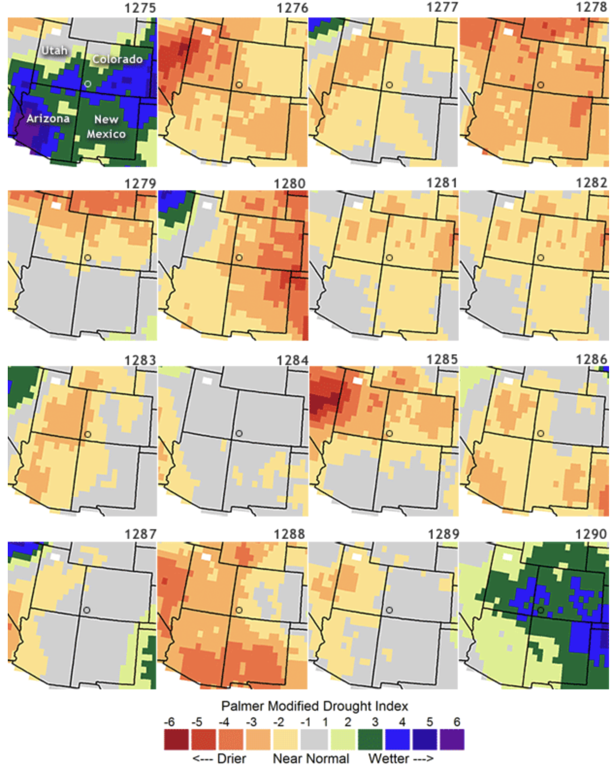


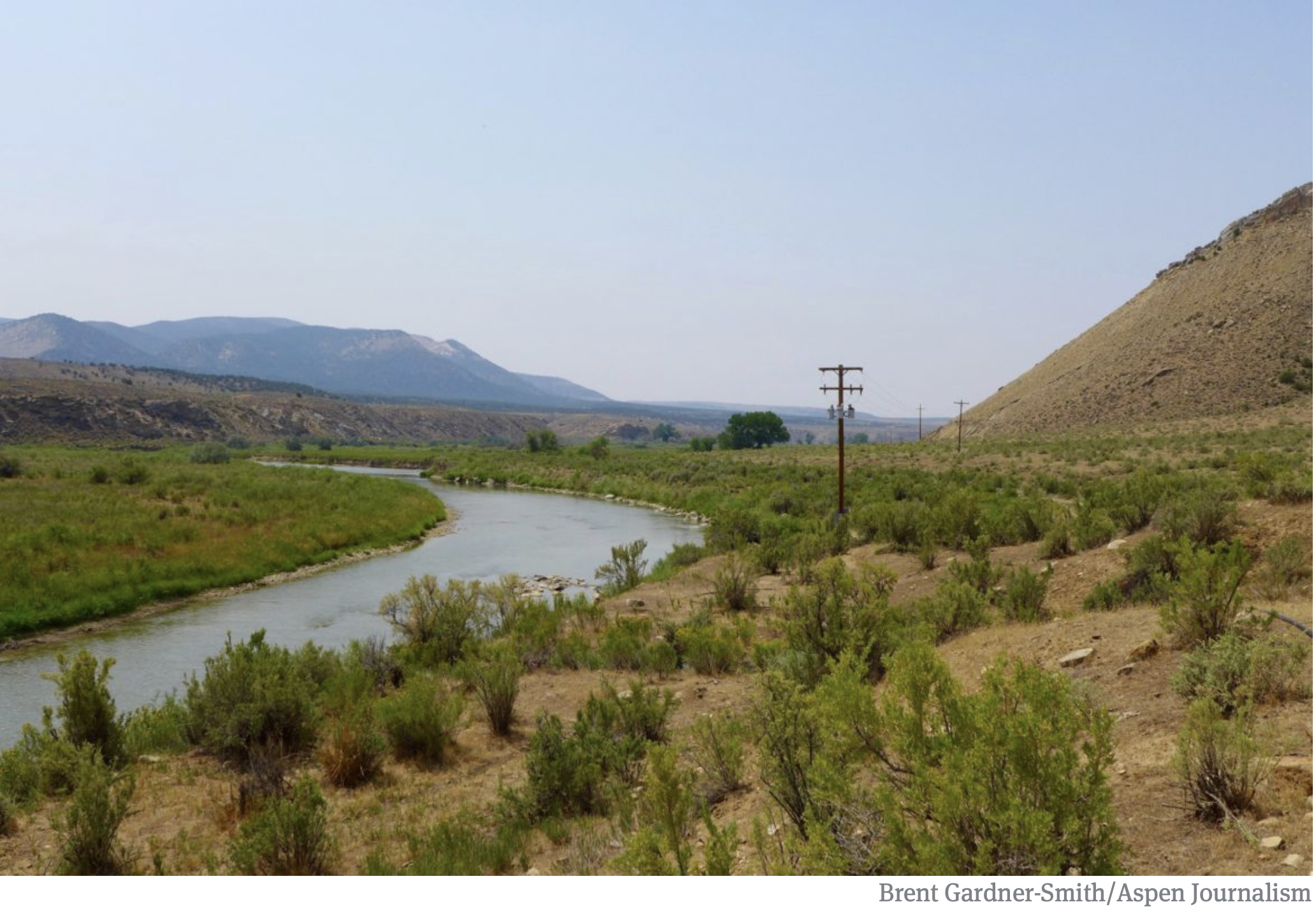

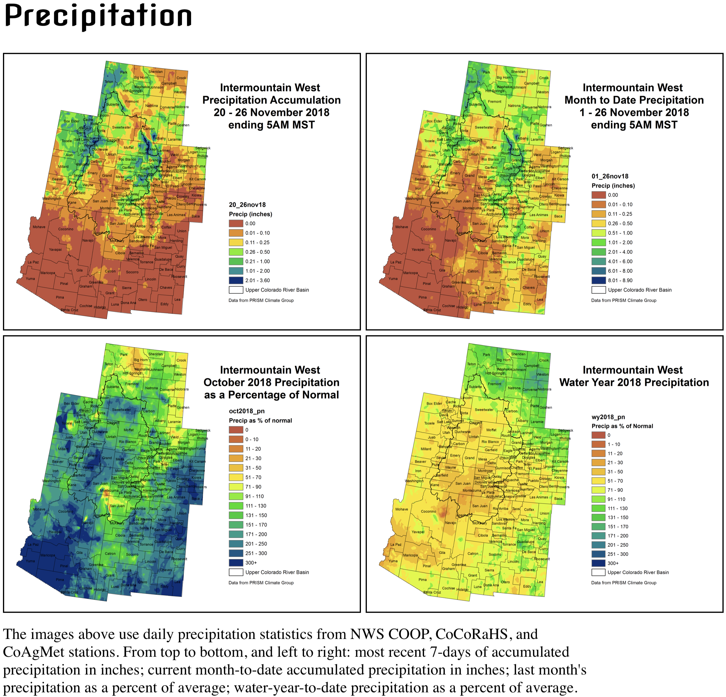


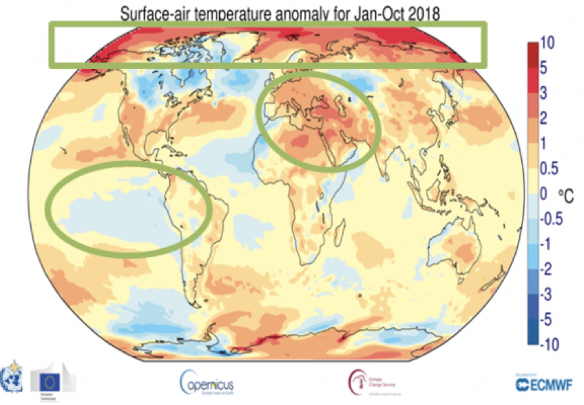
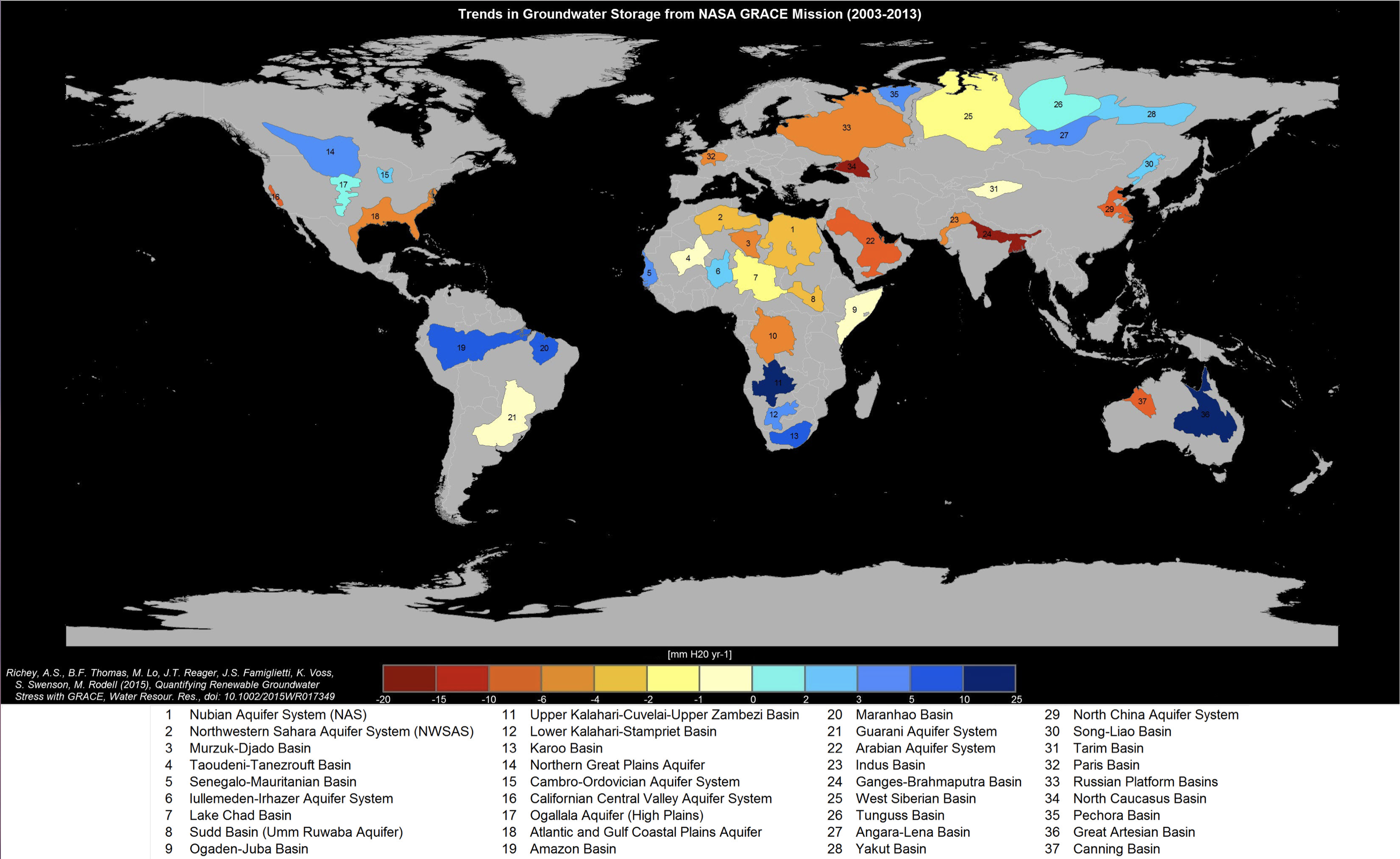
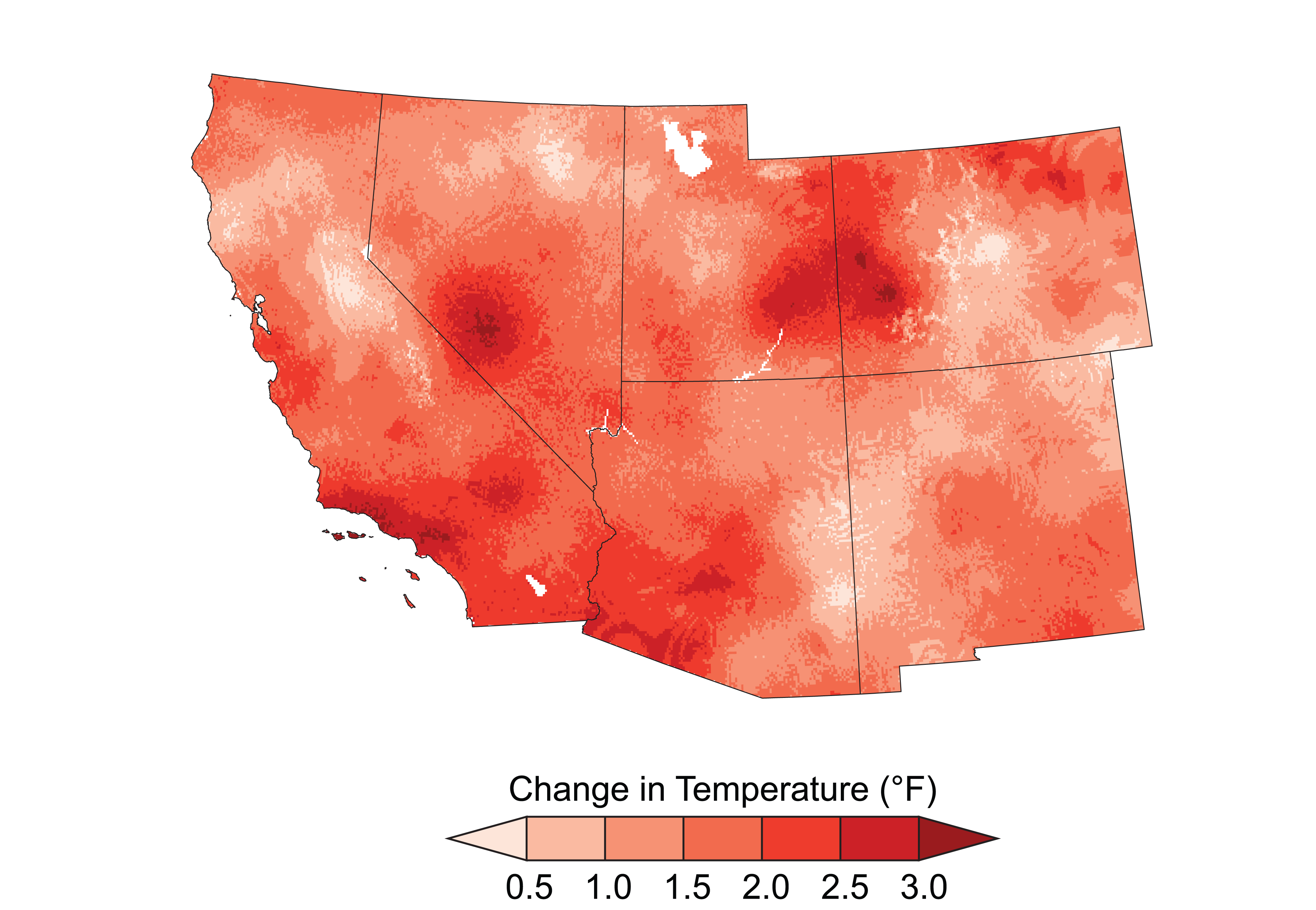
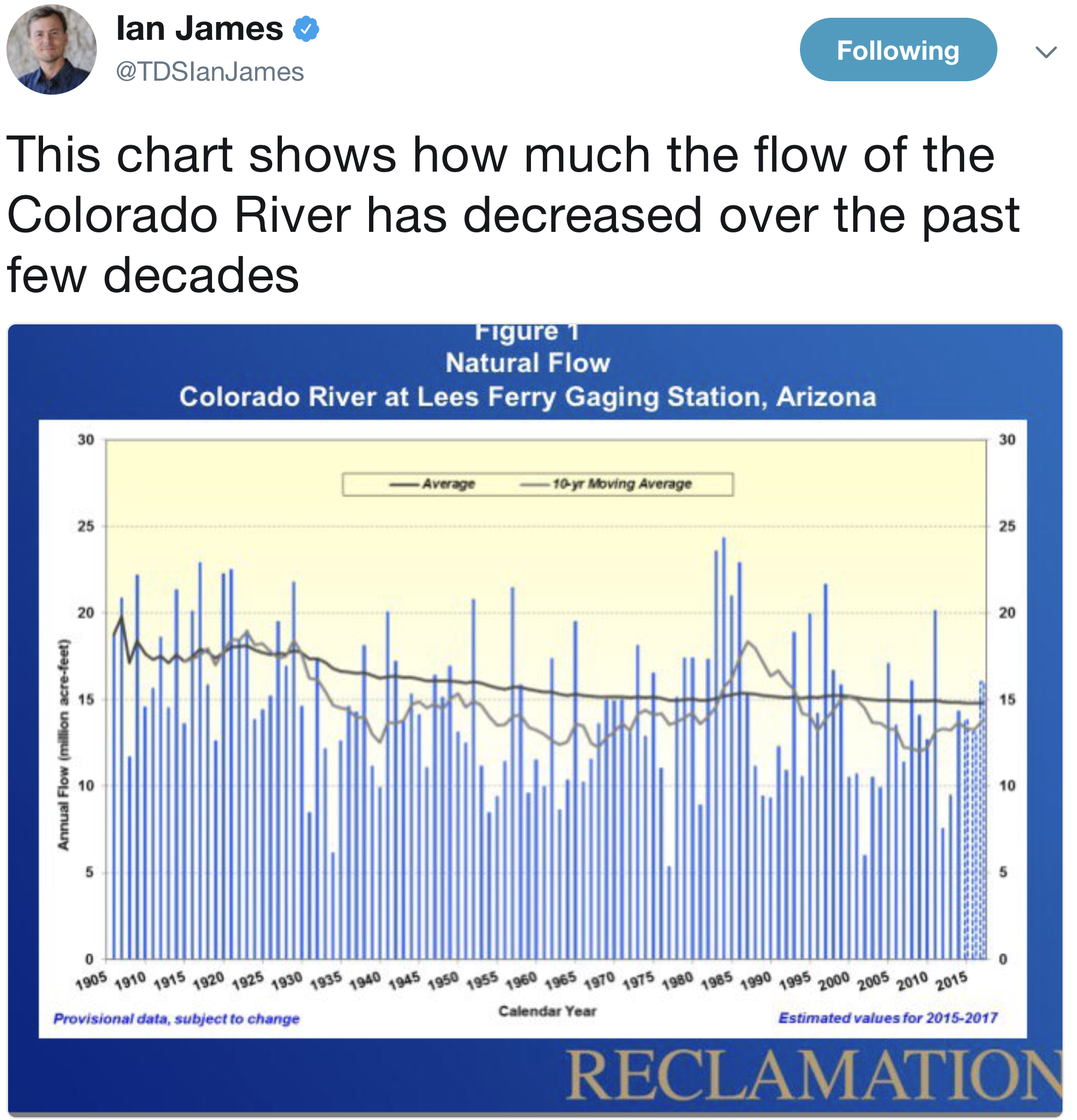


![The U.S. Whitewater Rafting Team trains on its custom-built raft in December on the Colorado River. The team was on pace for a record descent of the 277-mile canyon [January 14-15, 2017] when a wave broke the frame and punctured a tube. Photo Special to The Denver Post by Forest Woodward.](https://i0.wp.com/coyotegulch.blog/wp-content/uploads/2017/01/whitewaterraftgrandcanyonrecordattempt012017denverpost.jpg?w=293&h=195&ssl=1 "BZXXGRANDCANYON3.jpg")

 is a popular place for boaters to stop and admire the striking blue-green water of Havasu Creek. The turquoise color is caused by water with a high mineral content. At the point where the blue creek meets the turbid colorado river there often appears a definite break. NPS photo by Erin Whittaker.")