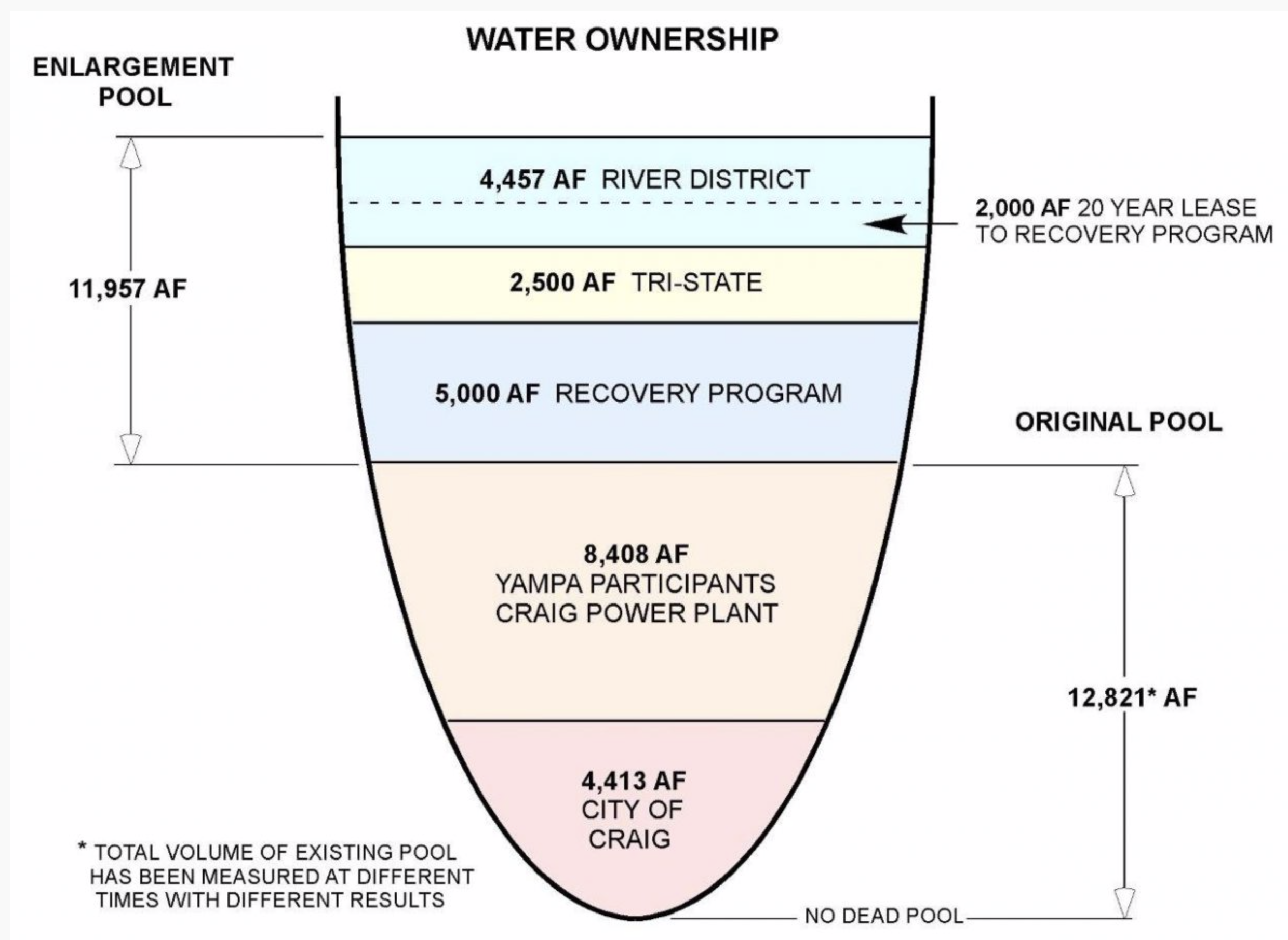
Elkhead Reservoir “teacup” graphic illustrates who owns water stored at Elkhead, measured in acre-feet or AF, both before and after it was expanded in 2006. Credit: The Craig Daily Press
…in dry, hot years like 2018, owners of Elkhead water were glad to have the backup.
“The reservoir served a good purpose for multiple reasons in Moffat County,” said Jim Pokrandt, director of community affairs for the Colorado River District.
Both the Upper Colorado River Endangered Fish Recovery Program and Tri-State Generation & Transmission had to call on their water stored at Elkhead this year. They are among four major owners of water in the reservoir, which also includes the city of Craig and the river district. The city drew ample water from the Yampa and didn’t need Elkhead water this year.
The Fish Recovery Program owns 5,000 acre-feet of water, which it procured when the reservoir was expanded in 2006 in exchange for a $13.5 million contribution to the project. An acre-foot is enough to cover one acre, about the size of a football field, with one foot of water, or about 326,000 gallons.
The Recovery Program also has the option to lease an additional 2,000 acre-feet from the River District, bringing its total to 7,000 usable acre-feet of water…
The Recovery Program utilized every drop of its 7,000 acre-feet, releasing water into the Yampa beginning in late July — unusually early — and continuing until October.
With the prolonged summer drought, Yampa flows dropped to a precipitously low 38 cubic feet per second by early October in Maybell, where the United States Geological Survey operates a stream gauge. The Maybell gauge is used to determine how much water is making it downriver and how much to release from Elkhead. For comparison, the Recovery Program ordinarily aims to keep flows at 93 cfs or greater, Anderson said.
Drought poses some obvious challenges to native fish populations. Colorado pikeminnow can reach lengths of 2 to 3 feet, according to Tom Chart, director of the Recovery Program, and low flows in the river can make it difficult for them to swim…
When river flows dropped too low this year, Tri-State called on its water in both Elkhead and Stagecoach reservoirs to keep the plant operational.
From Elkhead, it used 341 acre-feet of water, according to the River District, though it owns much more. Tri-State secured 2,500 acre-feet of water when the reservoir was expanded, plus it owns a portion of an 8,408 acre-foot pool shared by owners of Craig Station Units 1 and 2. Additionally, Tri-state owns 4,000 acre-feet of storage in Yamcolo Reservoir and 7,000 acre-feet in Stagecoach, according to the 2004 Yampa River Basin report.
Tri-state would not divulge how much water it used from Stagecoach this year. According to historical data provided in the 2004 report, however, Craig Station’s annual water use averaged more than 11,000 acre-feet per year between 1985 and 1991. Again, Tri-state declined to provide more recent data.
Decisions about how much water to release out of Elkhead are evaluated in a weekly phone call between the reservoir’s partners and users, state officials, meteorologists, irrigators, and other stakeholders, all led by Anderson. Water levels in the reservoir dropped slightly lower than average this year, down to 12 feet instead of 14 — revealing more shoreline than some are used to seeing — but recreational use of the reservoir by fisherman and boaters wasn’t significantly affected.
The reservoir collects water from a 205-square-mile basin and reliably recharges with spring runoff each year. Water managers worry about what would happen if drought persisted for several years, but so far, Elkhead has offered a measure of security to Moffat County’s biggest water users.
Richard Mulledy, the city’s stormwater manager, said the city annually builds 65 projects at a cost of $12 million.
“Five to 10 of those are major projects, maybe $500,000 or more,” he said.
Among the projects this year, the city recently finished construction of a retaining wall on the north end of Centennial Boulevard.
“It traps sediment that runs off from a steep hill after it rains,” he said. “Before, it would accumulate on the road and on the cul-de-sac of an adjacent neighborhood. Now it traps the sediment so that we can safely remove it. It saves us time and money. We identified this as a need five years ago.”
Kris Gates has lived in the neighborhood for 20 years.
“It’s been an issue ever since I moved in here,” she said. “No one told us about it. But the city came in, repaired the damaged curbs and sidewalks, and even part of our driveways. They repaved the cul-de-sac. It looks nice now. We’ll see if it passes the first test when it rains.”
Among projects planned for next year are several retention basins, including one underground on two blocks of Vermijo Avenue downtown.
The city began assessing a stormwater fee this summer to finance stormwater projects. Much of previous work was paid for with TABOR refunds, in which voters gave the city permission to keep excess tax revenue.
The fee was pushed by [Mayor John Suthers] and approved by voters last fall.
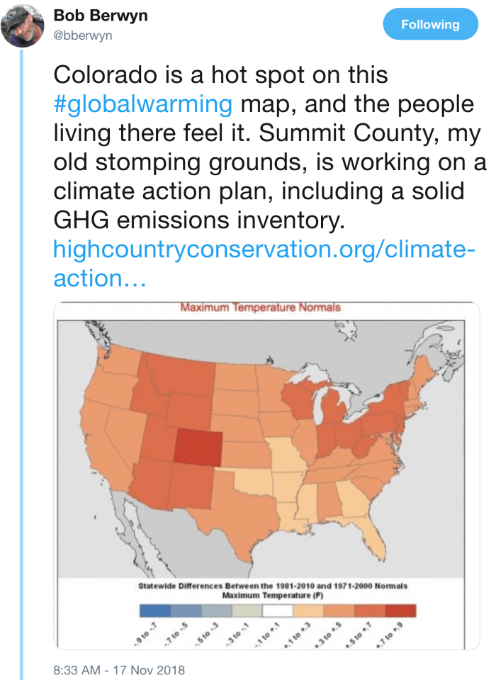
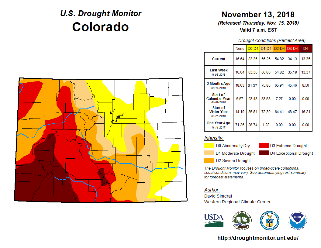
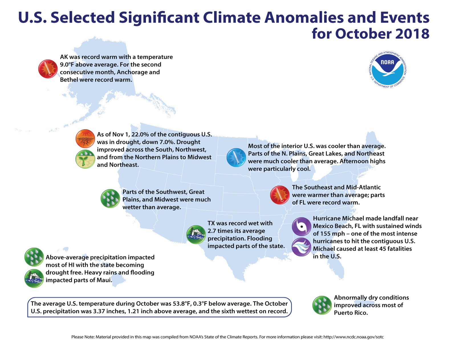
In south central Colorado, extreme drought was replaced with severe conditions in western Las Animas and southern Huerfano counties. Slivers of several north central counties saw abnormally dry conditions overtake moderate drought.
Drought was unchanged across the remainder of the state, including southwest Colorado, which continues to suffer under exceptional drought – the worst category…
Early snowpack gives some reason for hope. Snow water equivalent levels for Front Range mountain areas, along with the Sangre de Cristos and Mosquito Range in the central part of the state are above normal for this time of year according to the National Drought Mitigation Center…
Overall, 17 percent of Colorado was drought-free or abnormally dry, both unchanged from the previous week. Eleven percent of the state was in moderate drought, down one point. Severe drought is impacting 21 percent of Colorado, up from 20 percent one week ago. Extreme drought dropped one point to 21 percent, and exceptional drought was unchanged at 13 percent.
In the midst of record-breaking heat and drought this year, Craig residents have been blissfully buffered from the water worries of the rest of the county and the state. Even as the Yampa River turned to a trickle by the time it reached Dinosaur National Monument, the City of Craig had all the water it needed.
The reason for this has a lot to do with water rights and good planning on the part of Craig’s forefathers…
The Yampa River is Craig’s main source for drinking water. Some of the city’s water rights date back as early as 1883, according to Dan Davidson, director of the Museum of Northwest Colorado. Situated right next to the river, the water treatment plant diverts the water it needs through an intake structure. Even with this year’s historically low flows, “there were never any issues drawing water into the plant,” Sollenberger said.
And while the main source is the Yampa, Craig has even more water stored as a backup at Elkhead Reservoir, constituting more than a two year’s supply.
“With our senior water rights coupled with backup emergency storage at Elkhead… we’re pretty secure,” Sollenberger added.
In the 20 years he’s been on the job, Sollenberger said he has never had to draw any water from Elkhead. The reservoir reliably refills each spring with runoff from the 205-square-mile basin that drains into the reservoir (though a string of bad snow years could change that). This year, the reservoir is only slightly lower than usual at about 14 feet below capacity compared to a more typical 12 feet at this time of year, Sollenberger said, though it can look dramatically lower because of the exposed shoreline.
At a time when water worries are skyrocketing statewide, conservation is a hot topic in many municipalities, but Craig is not alone in enjoying water aplenty.
“Water use anywhere in Colorado is really locally oriented,” said Jim Pokrandt, Director of Community Affairs for the Colorado River District. “Craig is not unique in that they have great water rights and didn’t have to ask residents to cut back. And you have to remember that they’re in the water-selling business too, so the less water that gets used, the less they make. That’s the case with everybody.”
Mount Sopris and Hay Park via the @EcoFlight1 Wildlands set.
FromThe Glenwood Springs Post Independent (Thomas Phippen) via The Aspen Times:
The day-long conference featured student presentations, discussion periods where students talked to each other and the adults in attendance, and speakers including Christa Sadler, author of recent book “The Colorado” about nine eras of human interaction with the Colorado River.
The Pitkin County Healthy Rivers and Streams Program hired Sarah Johnson with Wild Rose Education to organize the event. Johnson began coordinating with teachers last spring to get the students to think about projects. During the fall, Johnson went to the schools to work with the students on the projects and teach basic river science.
“I facilitate a process where the kids get to understand that the things they care about are important,” Johnson said in an interview. “It’s not about what teachers care about, it’s about what students care about. What they care about and are curious to know more about, they can research, and form an opinion that’s based in evidence.”
WATER EXPEDITIONS
Sixth graders at Glenwood Springs Middle School visited Mitchell Creek Fish Hatchery to collect samples of insects that live on or near the water, some of which are extremely sensitive to water pollution. The students found about seven species of macroinvertebrates, but the most common was the stonefly, which is extremely sensitive to pollutants and cannot survive in dirty water.
GSMS uses the Expeditionary Learning model. Researching river health through macroinvertebrates helped students get outside the classroom and learn about an important topic.
“I think it was really fun to be outside and do something active. I think that hands-on activities are more important than others,” GSMS sixth grader Max Mazur said.
The students concluded in their presentation that the river was healthy, but as student presenter Damien Christie said in the presentation, macroinvertebrates “can help us understand our rivers and ecosystems, they can show us that the environment is changing, and they can help us monitor climate change.”
[…]
A group of seventh graders at GSMS studied how restaurants affect the Colorado River, and the eighth graders made a video about climate change.
Coal Ridge High School juniors Aidan Boyd and Erin Flaherty presented an overview of the arguments for and against developing the South Canyon area near Glenwood Springs. They sampled the water of the creek and found dangerously high levels of E. coli and potentially harmful alkalinity.
Various proposals for South Canyon development include incorporating the natural hot springs into a resort and providing camping amenities, boosting tourism and allowing for the river to be cleaned up. But other groups wish the land to remain as open space…
COLLEGIATE PERSPECTIVE
The summit brought together students from Coal Ridge, Glenwood Springs High School, GSMS, Aspen High School and Carbondale Middle School. But the event was not just for middle and high school students.
Through EcoFlight, a conservation advocacy group that organizes flights throughout the West to examine watershed areas from above, students from Colorado Mountain College, Colorado State University, Colorado Mesa University, Adams State University and Western Colorado University shared perspectives from a three-day trip.
During the trip, the students met with farmers and local officials, Native American groups and conservationists, organized by EcoFlight program coordinator Michael Gorman…
Jonathan Williams, who studies environmental policy at CSU, found himself ready to step into an advocacy role after the three-day trip.
He was familiar with the Colorado River area after years as a river guide, but after “seeing it from above, and talking to the communities, in relatively quick succession,” Williams said he found that all the pieces came together and were pushing him to pursue conservancy…
CMC photography major Sarah Cherry said the trip gave her a concrete basis for pursuing conservation through art…
BROADENING THE CONVERSATION
The thrust of the Youth Water Summit was to connect students and young adults to river issues, but the message was not one of strict conservation. The discussions ranged from what local politicians can do to improve water use to how community members and students can advocate for river health…
One potential shortcoming with events like the water summit and programs like EcoFlight, one audience member pointed out, is that participants tend to already be interested in environmental causes.
Map of oil shale and tar sands in Colorado, Utah and Wyoming — via the BLM
FromThe Grand Junction Daily Sentinel (Dennis Webb):
Petroteq Energy, formerly MCW Energy Group, has built a facility at Asphalt Ridge outside Vernal and is using what it says are benign solvents to produce oil from oil sand deposits. The company says its approach uses no water, produces no waste or greenhouse gas and doesn’t require high temperatures.
It is working to ramp up production to the plant’s capacity of 1,000 barrels a day.
The company said this month it received a small-source exemption from the Utah Division of Air Quality for its facility, allowing it to begin sales. It said in a news release that it got the exemption because the plant’s estimated emissions are less than the level for which a permit is needed, “further confirmation that Petroteq’s process is an environmentally conscious method of oil extraction.”
Oil sands are also known as tar sands or bituminous sands, and contain a heavy oil also described as asphalt or bitumen.
Petroteq says its leases have 93 million barrels of estimated oil resource. Eastern Utah is home to the largest oil sands resources in the country, with resource estimates running as high as 32 billion barrels…
Petroteq’s project is at Asphalt Ridge, which the federal Bureau of Land Management has reported has been the target of oil/tar sand exploration and development efforts as early as the 1920s, when Vernal paved its streets from Asphalt Ridge deposits.
Work there included a plant that used hot water to extract oil in the 1930s. Hot water also is used in Canadian tar sands development that also incorporates tailing ponds. “Our ‘Asphalt Ridge’ asset has (from time to time) caught the attention of major oil companies going back 70 years. But nobody has been able to unlock its resources in a financially sound and environmentally friendly manner until the Petroteq team and its proprietary technology came along,” David Sealock, Petroteq’s chief executive officer, said in a recent news release announcing the company’s start of commercial production.
The company says its focus is on development and implementation of proprietary technologies for environmentally safe production of heavy oil from oil sands, oil shale and shallow oil deposits. Northwest Colorado and northeastern Utah are home to world-class deposits of oil shale, rock containing kerogen-like hydrocarbon deposits.
The efforts of companies like Petroteq continue to be criticized by groups including Utah Tar Sands Resistance, which says on its website, “The production of tar sands in Utah is a story of false claims and impossible promises with a long history of failed companies, bankruptcies and name changes.”
Thirty years ago, this magazine published “The End of Nature,” a long article about what we then called the greenhouse effect. I was in my twenties when I wrote it, and out on an intellectual limb: climate science was still young. But the data were persuasive, and freighted with sadness. We were spewing so much carbon into the atmosphere that nature was no longer a force beyond our influence—and humanity, with its capacity for industry and heedlessness, had come to affect every cubic metre of the planet’s air, every inch of its surface, every drop of its water. Scientists underlined this notion a decade later when they began referring to our era as the Anthropocene, the world made by man.
I was frightened by my reporting, but, at the time, it seemed likely that we’d try as a society to prevent the worst from happening. In 1988, George H. W. Bush, running for President, promised that he would fight “the greenhouse effect with the White House effect.” He did not, nor did his successors, nor did their peers in seats of power around the world, and so in the intervening decades what was a theoretical threat has become a fierce daily reality. As this essay goes to press, California is ablaze. A big fire near Los Angeles forced the evacuation of Malibu, and an even larger fire, in the Sierra Nevada foothills, has become the most destructive in California’s history. After a summer of unprecedented high temperatures and a fall “rainy season” with less than half the usual precipitation, the northern firestorm turned a city called Paradise into an inferno within an hour, razing more than ten thousand buildings and killing at least sixty-three people; more than six hundred others are missing. The authorities brought in cadaver dogs, a lab to match evacuees’ DNA with swabs taken from the dead, and anthropologists from California State University at Chico to advise on how to identify bodies from charred bone fragments…
Scientists have warned for decades that climate change would lead to extreme weather. Shortly before the I.P.C.C. report was published, Hurricane Michael, the strongest hurricane ever to hit the Florida Panhandle, inflicted thirty billion dollars’ worth of material damage and killed forty-five people. President Trump, who has argued that global warming is “a total, and very expensive, hoax,” visited Florida to survey the wreckage, but told reporters that the storm had not caused him to rethink his decision to withdraw the U.S. from the Paris climate accords. He expressed no interest in the I.P. C.C. report beyond asking “who drew it.” (The answer is ninety-one researchers from forty countries.) He later claimed that his “natural instinct” for science made him confident that the climate would soon “change back.” A month later, Trump blamed the fires in California on “gross mismanagement of forests.”
Human beings have always experienced wars and truces, crashes and recoveries, famines and terrorism. We’ve endured tyrants and outlasted perverse ideologies. Climate change is different. As a team of scientists recently pointed out in the journal Nature Climate Change, the physical shifts we’re inflicting on the planet will “extend longer than the entire history of human civilization thus far.”
The poorest and most vulnerable will pay the highest price. But already, even in the most affluent areas, many of us hesitate to walk across a grassy meadow because of the proliferation of ticks bearing Lyme disease which have come with the hot weather; we have found ourselves unable to swim off beaches, because jellyfish, which thrive as warming seas kill off other marine life, have taken over the water. The planet’s diameter will remain eight thousand miles, and its surface will still cover two hundred million square miles. But the earth, for humans, has begun to shrink, under our feet and in our minds.
“Climate change,” like “urban sprawl” or “gun violence,” has become such a familiar term that we tend to read past it. But exactly what we’ve been up to should fill us with awe. During the past two hundred years, we have burned immense quantities of coal and gas and oil—in car motors, basement furnaces, power plants, steel mills—and, as we have done so, carbon atoms have combined with oxygen atoms in the air to produce carbon dioxide. This, along with other gases like methane, has trapped heat that would otherwise have radiated back out to space.
There are at least four other episodes in the earth’s half-billion-year history of animal life when CO2 has poured into the atmosphere in greater volumes, but perhaps never at greater speeds. Even at the end of the Permian Age, when huge injections of CO2 from volcanoes burning through coal deposits culminated in “The Great Dying,” the CO2 content of the atmosphere grew at perhaps a tenth of the current pace. Two centuries ago, the concentration of CO2 in the atmosphere was two hundred and seventy-five parts per million; it has now topped four hundred parts per million and is rising more than two parts per million each year. The extra heat that we trap near the planet every day is equivalent to the heat from four hundred thousand bombs the size of the one that was dropped on Hiroshima.
As a result, in the past thirty years we’ve seen all twenty of the hottest years ever recorded. The melting of ice caps and glaciers and the rising levels of our oceans and seas, initially predicted for the end of the century, have occurred decades early. “I’ve never been at . . . a climate conference where people say ‘that happened slower than I thought it would,’ ” Christina Hulbe, a New Zealand climatologist, told a reporter for Grist last year. This past May, a team of scientists from the University of Illinois reported that there was a thirty-five-per-cent chance that, because of unexpectedly high economic growth rates, the U.N.’s “worst-case scenario” for global warming was too optimistic. “We are now truly in uncharted territory,” David Carlson, the former director of the World Meteorological Organization’s climate-research division, said in the spring of 2017, after data showed that the previous year had broken global heat records.
Arizona is once again at a critical decision point in the ongoing struggle to secure our water resources. If we fail to take the right course, we risk igniting yet another Colorado River water war.
Lake Mead, from which we draw our share of the Colorado River, is dropping to perilous levels. In order to stabilize lake levels and protect our water supply, the Department of Water Resources has negotiated an agreement with California and the other basin states to begin reducing water diversions from the Lake.
California and the other basin states are ready to sign the agreement, known as the Drought Contingency Plan (DCP). Arizona is the lone holdout, mainly because our state Legislature, caught up in special interest demands, has failed to ratify the DCP agreement.
CAWCD is overstepping its role
Behind this legislative impasse are two groups threatening to block ratification.
The first is the Central Arizona Water Conservation District (CAWCD), a local elected body that distributes our Colorado River water throughout central Arizona.
CAWCD is now reaching beyond its proper role by attempting to intervene in the interstate Colorado River negotiations.
These interstate negotiations are the exclusive job of the Department of Water Resources, whose director is appointed by the governor to represent all Arizonans…
Pinal County districts also are a threat
The second threat to legislative ratification of the DCP comes from the Maricopa Stanfield Irrigation and Drainage District, the Central Arizona Irrigation District and several other agricultural districts located in Pinal County.
In 2004, these Pinal districts signed onto a far-reaching water settlement agreement worked out under the leadership of Sen. Jon Kyl. In that settlement the districts agreed that their use of Colorado River water would be phased out not later than 2030, after which they would go back to full reliance on groundwater.
In exchange for giving up long-term rights to Colorado River water and pumping more local groundwater, the districts bargained for and received heavily subsidized Colorado River rates to be paid for by property taxes levied on landowners in Phoenix, Tucson and throughout central Arizona…
It matters a lot. If the Drought Contingency Plan is not ratified soon California and the other Basin states may decide to proceed without us. That could be the beginning of another Colorado River water war.
Arizona has blundered into Colorado River wars in the past, and we usually lose. We must not go that way again. It is up to the Legislature and Gov. Doug Ducey to promptly ratify the Drought Contingency Plan as negotiated by the Department of Water Resources.
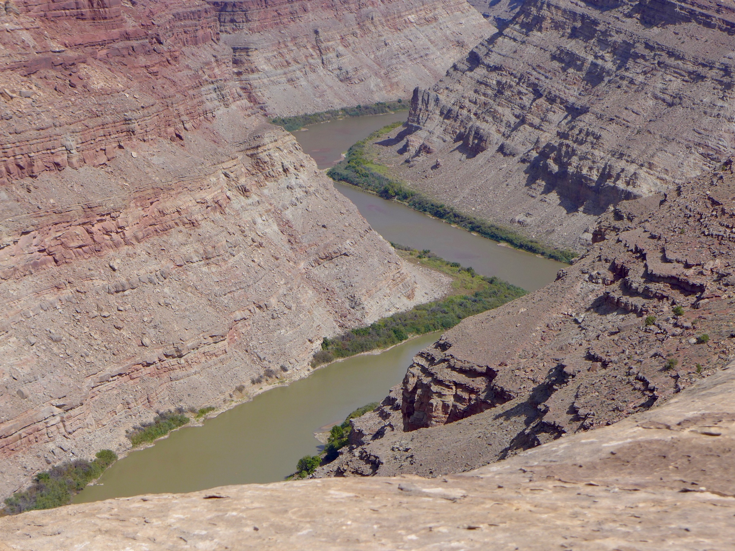
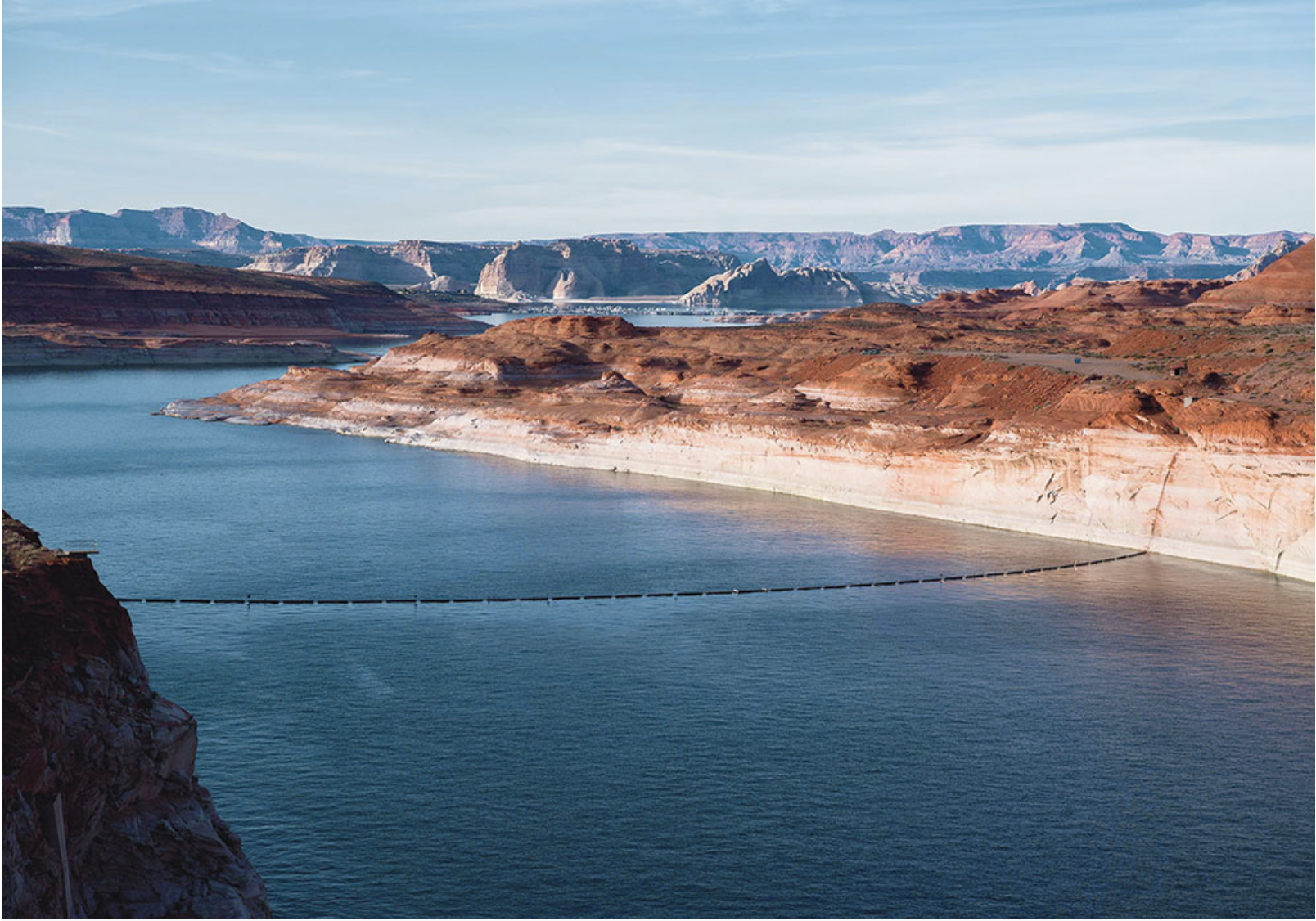
Looking upriver at the confluence of the Green and Colorado rivers in late September, one of the driest years on record for the Colorado River system. Water managers in both the upper and lower basins are working to get more water to this point in order to bolster the low level of Lake Powell, which is not far downstream.
The state of Colorado is now officially on board with a regional water strategy designed to keep enough water in Lake Powell behind Glen Canyon Dam to avoid violating the Colorado River Compact and keep generating hydropower at the dam.
At a meeting Thursday in Golden, the directors of the Colorado Water Conservation Board unanimously adopted a state policy giving its “full support” to proposed drought-contingency plans and agreements now being reviewed in both the upper and lower Colorado River basins.
“I think we’ve really done something important for the state today,” Russ George, a CWCB director from Rifle who represents the Colorado River basin within Colorado, told a meeting room filled with water managers, water users and water attorneys from around the state.
The new policy means Colorado, along with the other upper basin states of Utah, Wyoming and New Mexico, can declare its support for the drought-contingency plans (DCP) and agreements at a mid-December meeting in Las Vegas of the Colorado River Water Users Association.
The lower basin states of California and Nevada also are in support of the agreements, but water managers in Arizona are still working through a series of contentious, complicated issues and have yet to reach consensus.
If consensus in both basins can be reached by mid-December, legislation may be introduced during the current lame-duck session of Congress.
A sense of urgency to do something about the falling water levels in Lake Powell has been growing, and was heightened in Colorado in 2018 by the hot and dry conditions.
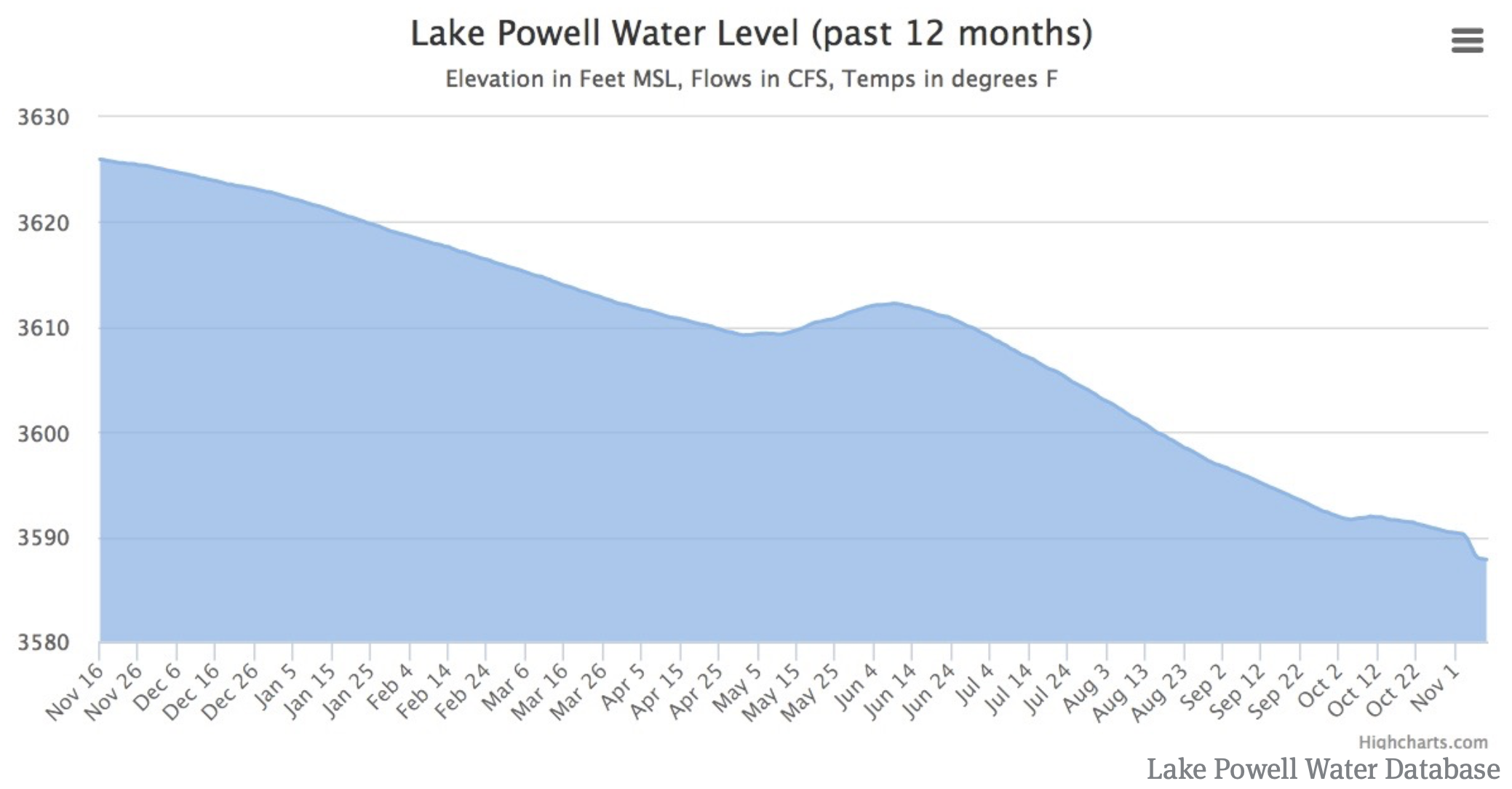
Lake Powell on Friday, November 15 was at 44 percent full and at an elevation of 3,588 feet above sea level on the upstream face of Glen Canyon Dam. That’s 98 feet above the “minimum power pool” level of 3,490 feet.
The reservoir level has dropped by 38 feet in the last year, and water officials are concerned if dry conditions persist, the reservoir could reach the minimum power pool level within three years.
Operations, and reservoir levels, in Lake Powell are tied by regulatory guidelines with levels in Lake Mead, which is 38 percent full today. The new DCP storage pool in Lake Powell would be exempt from the operating guidelines, however, and would serve as a secure, and separate, savings account within Lake Powell for the upper basin states.
A graphic showing the 38-foot-drop in the surface level of Lake Powell over the last year, from the website, lakepowell.water-data.com. Regional water managers want to keep the reservoir above minimum power pool level of 3,490 feet.
Bridging the divide
The new Colorado state policy adopted Thursday was crafted by staff members at the CWCB, a state agency within the Dept. of Natural Resources, and the attorney general’s office to bridge the latest chasm that had emerged between water managers on the Western Slope and the Front Range.
Water officials on both sides of the Continental Divide want to store water in Lake Powell in a regulatory pool controlled by the upper basin, with the goals of first, keeping the reservoir levels high enough to keep producing hydropower at the dam, and second, high enough to continue to release enough water from the dam to meet the upper basin’s downstream obligations under the Colorado River compact.
But exactly how water that is now being consumed by farmers and ranchers and city dwellers will be conserved and sent downstream to fill the new pool in Lake Powell is uncertain, and a key issue is whether the state might require mandatory cuts in water use to fill the new pool to avoid a compact call.
The Western Slope, lead by the Colorado River District in Glenwood Springs, also wanted the state to help ensure that the creation of the new pool of water didn’t lead to a buy-and-dry of irrigated agriculture on the Western Slope.
And they wanted assurances that the state would use a public process to devise any new rules or laws requiring mandatory cutbacks in water use, should low water conditions persist.
Meanwhile, Front Range water interests wanted to make sure that the state didn’t tie its own hands and restrict its abilities to take steps to avoid a compact.
The confluence of the Green and Colorado rivers, in September 2018. Most of the water that flows into Lake Powell each year flows past this remote spot in Canyonlands National Park.
Responsive to concerns
The state’s new policy says it will use an open public process to create a “demand management,” or water-use reduction, program that incentivizes water users — primarily irrigators — to temporarily cut back on their consumptive use of water, in exchange for monetary compensation.
And if mandatory cutbacks in water use are ever necessary, “any alternative measures or rules for compact compliance administration” will be developed after “timely and extensive public outreach” and with “the goal, but not the requirement, of achieving general consensus within the state,” the policy says.
“The CWCB was very responsive to our request that they display state leadership in establishing a policy that going forward provides some security for the Western Slope and other regions of the state, and that no one region is going to suffer the brunt of a demand-management program,” said Andy Mueller, the general manager of the Colorado River District, after the meeting.
Mueller also said the CWCB “clearly separated demand management from some form of involuntary curtailment. It was very important to do that, as they are two different things.”
Both Mueller and Bruce Whitehead, the general manager of the Southwestern Water Conservation District in Durango, thanked the CWCB board for listening to their concerns, and drafting a policy that attempted to address them.
“This was a hot topic,” said Whitehead.
Between the two, the Colorado River District and the Southwestern District represent all of the Western Slope. Both Mueller and Whitehead said they will recommend to their boards that they formally endorse the state’s policy at their upcoming board meetings.
The Front Range Water Council, an ad hoc group that includes the major municipal water providers between Fort Collins and Pueblo, sent the CWCB a letter of support for the DCP policy, urging adoption “without any changes.”
“Thank you for your thoughtful consideration of public input on this topic of critical importance to Colorado, and for developing a policy that will allow Colorado to engage in further processes that will protect our collective interests in the Colorado River and Upper Colorado River compacts,” said the letter, which was signed by Jim Lochhead, the CEO of Denver Water and the head of the Front Range Water Council.
Patti Wells, who represents the Denver metro area on the CWCB, said it was important that Colorado not be split by differences between the east and west slopes.
“There clearly is more that unites us in the ability for Colorado not to be subject to a compact call, then there is in the details of how we might avoid that,” she said.
She also challenged water managers to come up with a demand-management program that “makes everyone better off.”
“We ought to be able to figure out a way to get some water into Lake Powell without doing harm to anyone, and really making it a program that will benefit all the participants to the extent that we can,” said Wells, who recently retired as the general counsel for Denver Water. “I see no reason why we can’t approach this in that way, because we are Coloradans for God’s sake, and we are not anyone else.”
Colorado closed out its second-driest water year on record Sept. 30, with 72 percent of the state in some level of drought.
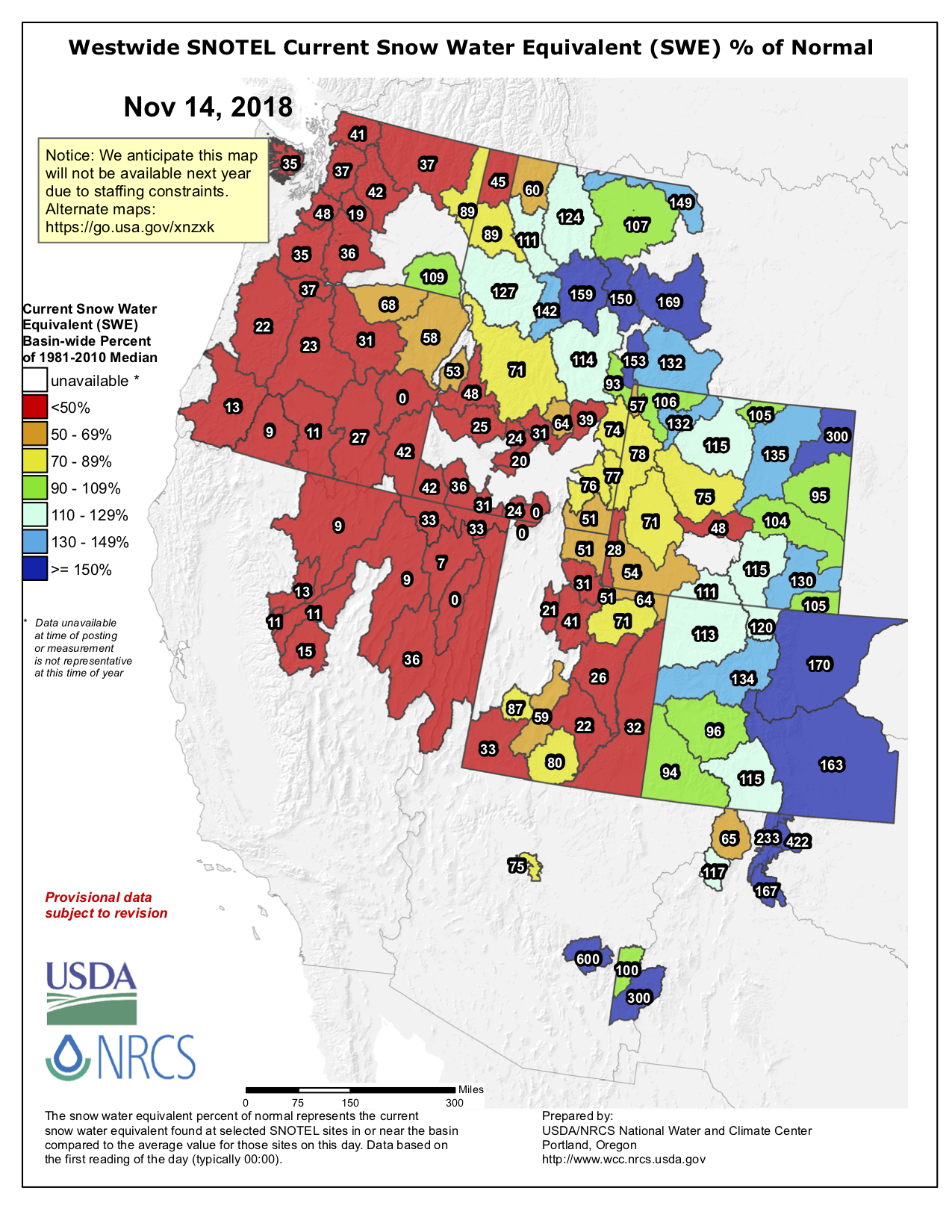
The water year, which started October 1 of 2017, was marked by abnormally high temperatures, low precipitation and some of the largest fires in Colorado history, but state climate scientists and hydrologists say the 2019 water year, which began Oct. 1, is off to a much better start.
“We are trending towards the path of a good or near-average water year,” Becky Bolinger, a research associate with the Colorado Climate Center, said at a statewide water-availability task force meeting Tuesday in Denver.
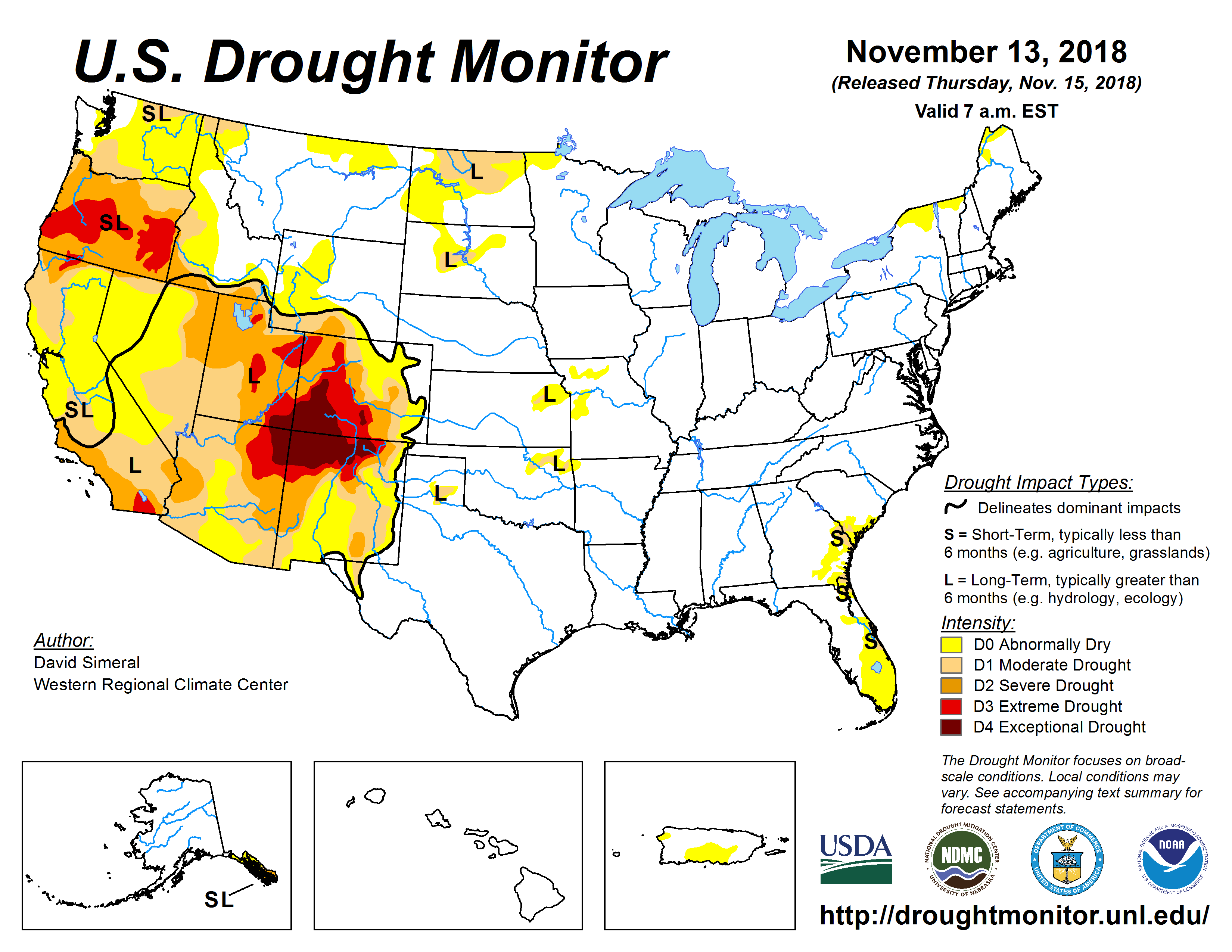
Colorado Drought Monitor November 13, 2018.
Still dry
October and the first half of November saw above-average precipitation and below-average temperatures in most of the state. While much of this precipitation along the Front Range will have little bearing on the water year as a whole, the heavy snowfall in the mountains near Grand Junction, on the Western Slope, will probably stick around until spring.
Despite a good start to the 2019 water year, water managers warn that a few early snowstorms will do little to lift Colorado from its water problems. The state has been in water-shortage conditions for almost two decades.
“I continue to be skeptical,” Russ George, a board member representing the Colorado River basin on the Colorado Water Conservation Board, said during the board’s meeting Thursday. “We know — and we need to keep telling the public — that this moisture doesn’t solve the Lake Powell problem.”
Lake Powell, the largest reservoir on the Colorado River, has dropped more than 94 feet since the year 2000 and is now 44-percent full.
If the reservoir falls much further, it will be below “minimum power pool,” and water will not be able to flow through the penstocks in the upstream face of the dam down to turbines near the base of the dam.
And if water levels drop even further, the surface of the reservoir will be below the level of the outlet pipes in the dam, and not enough water will be sent downstream to meet the legal obligations of the upper basin states as required by the Colorado River Compact of 1922.
The threat of El Niño has also tempered water managers’ celebration about recent snowfall.
Climate models show an 80 to 90 percent chance for a winter El Niño. The weather phenomenon typically causes drier weather in the northern part of North America and wetter weather in the south.
Since Colorado falls in the middle of the continent, El Niño weather patterns are hard to predict for the state, but past El Niños have left most of the mountains on the Western Slope drier than normal and sent large amounts of snow to the state’s southeastern corner.
Although an El Niño could be bad news for Western Slope ski resorts and limit the mountain snowpack that feeds the rest of the state, it could help alleviate drought conditions in the Four Corners region.
This section of the state experienced its worst drought this year since the Dust Bowl of the 1930s. To meet summer demand, the region drew down its reservoir storage to record levels and will need a wet winter to recoup those reserves.
“There’s a lot of winter to come, but that’s an encouraging start,” said Karl Wetlaufer, a hydrologist with the Natural Resources Conservation Service, which is part of the U.S. Department of Agriculture.
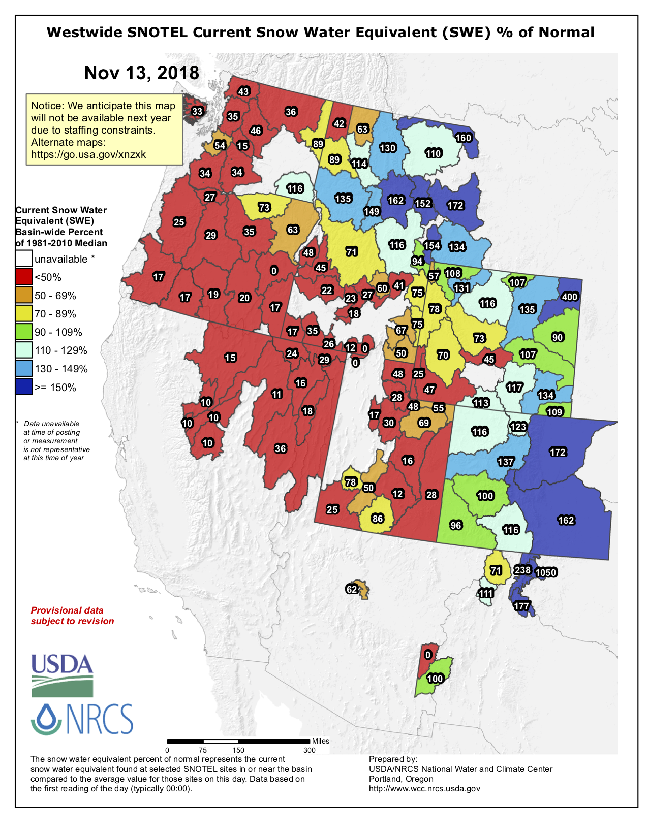
Westwide SNOTEL basin-filled map November 14, 2018 via the NRCS.
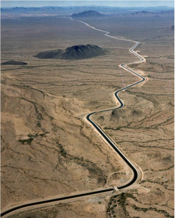
The Central Arizona Aqueduct delivers water from the Colorado River to underground aquifers in southern Arizona. UT researcher Bridget Scanlon recommends more water storage projects like the aqueduct to help protect against variability in the river’s water supply. U.S. Bureau of Reclamation.
The agency that delivers Colorado River water to parts of Arizona offered a new proposal Thursday amid difficult negotiations on a proposed deal aimed at preventing the declining levels of Lake Mead from dropping even further.
The Central Arizona Water Conservation District’s board members voted to pass a motion they described as an “interim mitigation plan.” The proposal lays out a scenario in which the agency could provide “mitigation water” to soften the blow for farmers in central Arizona who have the lowest priority in the state’s pecking order of water users.
The proposal quickly faced questions, however, because it calls for using some of the Central Arizona Project’s stored water in Lake Mead — called “Intentionally Created Surplus” or “ICS” water — at a time when the larger goal is to prevent the reservoir from falling to critically low levels.
“The broader community has not yet produced a consensus proposal. We’re working very hard on it,” CAP General Manager Ted Cooke told the district’s board. “We have brought the interim plan forward because we think it will work.”
[…]
Still uncertainty about details
A meeting billed as the committee’s final gathering is scheduled for Nov. 29, and both federal and state water managers have said they hope to finish a deal by December.
“There have been some productive conversations over the past few days,” said Suzanne Ticknor, CAP’s director of water policy. “Discussions are helping to move things forward.”
But she said three proposals have come and gone, and there is also uncertainty about the availability of funding to help compensate parties that would transfer some of their water elsewhere.
That proposal, intended to renew lagging DCP talks, was a bare-bones version that board members said they did not expect everyone to agree with. Nevertheless, they authorized Board President Lisa Atkins and Director Karen Cesare to present it to the next DCP Steering Committee meeting on November 29. Arizona had hoped to agree on a drought contingency plan by then, before meeting with California and Nevada officials in mid-December to discuss a broader Lower Basin DCP…
[Ted] Cooke said that the complexities of the plan could be worked out later, after a Drought Contingency Plan had been agreed upon by other states, passed by the Arizona legislature, and approved by Congress.
Cooke also said that his foremost concern was the cost of water: “What’s this going to do to our rates? I know that’s very important to our customers,” he said. He presented graphs showing that CAP’s fixed rates would increase if its water deliveries to customers decreased, as would occur without mitigation.
The seven Colorado River states are developing a DCP because an ongoing drought, now in its 19th year, is on track to worsen sooner than existing drought guidelines can accommodate.
Those guidelines, passed in 2007, were supposed to last until 2026. But Lake Mead, the reservoir on the Colorado River that supplies Arizona, Nevada, and California, has been given a 57 percent chance of falling into shortage in the year 2020. The DCP is supposed to be a six-year plan bridging the years 2020 to 2026.
During the meeting’s public comment period, representatives of other Arizona water users focused on several concerns. One was the new proposal’s reliance on intentionally created surplus (ICS) water sitting in Lake Mead. Another was the question of whether the latest plan was fair.
Like money in a savings account, ICS water has been stored by states in Lake Mead, with the idea that keeping it in the reservoir could help stave off shortage, which is declared when the reservoir’s level dips below 1,075 feet above sea level.
The ICS program, created by interim drought guidelines in 2007, allows states to pull that water out of the reservoir in the future, as long as no shortage has been declared.
The CAWCD board’s $36 million to $54 million proposal would cover three years. It would compensate users in the Non-Indian Agriculture (NIA) pool — mainly tribes and cities — 100 percent for their losses under a DCP. It would also compensate agriculture and developers for their cuts. For farmers, it promised to provide them with the 595,000 acre-feet of water through 2026 that the sector has been seeking.
To compensate these users, the proposal suggested pulling up to 400,000 acre-feet of water out of Lake Mead. To many participants in the DCP talks, who attended Thursday’s meeting, that sourcing was a problem, because that would mean using Lake Mead to compensate Arizona water users for reductions to their water supply from… Lake Mead.
“The CAP proposal in its current form does not conform to the state of Arizona’s guiding principles,” Tom Buschatzke, the director of the Arizona Department of Water Resources and the other co-chair of the Steering Committee, told the board Thursday. “The state wants to continue discussing the proposal and other proposals to synthesize the meritorious elements of each one, into a package acceptable to all.”
He pointed out that the proposal did not align with several principles for any DCP plan laid out by Governor Doug Ducey in an opinion article in the Arizona Capitol Times on Tuesday. Among them were that water must be left in Lake Mead, not taken out.
Governor Stephen Roe Lewis of the Gila River Indian Community echoed that point in his remarks. He reiterated a point the Community has made before — that it was “strongly opposed” to using water from Lake Mead, including ICS water, unless offset by other contributions to the reservoir. Mitigating cuts with other sources of water would raise costs, but that was something the Community was prepared for.
“Rates will have to go up, because DCP will have to become the new normal, and it is best to transition to that new reality sooner than later,” Lewis said.
Lewis reiterated, too, that the water cuts had to be shared equitably and fairly. “DCP cannot be used as subsidy for one affected group,” he said.
The Arizona agricultural sector seeks compensation of 595,000 acre-feet of water from 2020 to 2026, which many other stakeholders see as unfair, given that farmers would fare better with mitigation under DCP cuts than without. These stakeholders also point out that farmers gave up their legal contract to Colorado River water in a 2004 settlement.
Still, the agricultural sector pushed back against calls for equity and criticized the CAP plan.
“I’m disappointed that there are still some folks who think that is too much for agriculture,” said Paul Orme, general counsel for Pinal County agriculture districts. He argued that although agriculture interests had been trying to find ways to use groundwater instead of surface water from the Colorado River, the expectation of farmers had been that they would not have had to figure that out until 2031…
Bas Aja, a lobbyist for agricultural interests, tried to draw a distinction between equity in priorities and contractual agreements, and equity in the impact of cuts. “There’s no equity in impact in these proposals,” he said.
Despite these disagreements, during its meeting, the board added an important clause to the initial proposal, agreeing to “continue to negotiate a mitigation plan” within the general parameters of that proposal…
Cynthia Campbell, water advisor for the city of Phoenix, said that the new CAP plan had some “fundamental issues” in its use of ICS. “It doesn’t seem to make a lot of sense to us,” she said. “We think that there have been other discussions going on of other ways to do it, and that today’s action represents the board being expedient. This is the ‘easy button.'”
“Kudos to them that they’re trying to put a proposal forward,” Campbell added, “But we think that we can still do a little bit better to help protect Lake Mead.”
A major Colorado River water user has proposed an interim plan for Arizona as the state faces looming a looming deadline to manage expected shortages. The Central Arizona Project board said its proposal could jumpstart talks after previous ones failed to gain consensus among water users.
The agency wants to draw up to 400,000 acre-feet of water it stored in Lake Mead and 50,000 acre-feet in Lake Pleasant, and implement a $60 million conservation program to lessen the burden of shortages on mainly farmers and developers. Another program would help improve groundwater systems but doesn’t have a price tag.
The agency said the proposal theoretically would result in a net benefit to Lake Mead because it could not pull out as much water under regular deliveries in shortages, stabilizing the lake before it reaches a level where no one could get any water.
Arizona water users had a mixed response to the proposal presented at a board meeting Thursday. It covers only three years of a required seven-year, multistate plan to manage the shrinking Colorado River.
Arizona Gov. Doug Ducey said this week that any drought contingency plan has to align with four principles, one of which is to build on efforts to prop up the lake that determines how much water can be sent to Arizona, Nevada and California from the river’s lower basin.
“I will not sign a bill that does not adhere to these important principles, or any bill that does not adequately help to secure our state’s water future,” Ducey wrote in an opinion piece.
U.S. Bureau of Reclamation Commissioner Brenda Burman has said she wants a plan from the seven states that relies on the river by the end of the year. The upper basin states – Colorado, New Mexico, Utah and Wyoming – are working on a separate plan…
An Arizona drought contingency committee is scheduled to meet later this month to consider the Central Arizona Project proposal and any others. The Colorado River Indian Tribes recently offered 50,000 acre-feet of water to help reach agreement, with strings attached.
State Sen. Lisa Otondo struck an ominous tone in a recent letter to fellow committee members.
“The longer we argue and delay, the more we risk,” she said. “Time is our enemy. We are facing a common crisis and will all have to take a hit or face the judgment of history.”
[…]
Dan Thelander, whose family farms 5,000 acres in Pinal County, said he will have to fallow 2,000 acres under the Central Arizona Project proposal.
“This is a tough pill to swallow, but we understand it,” he said at Thursday’s meeting. “We’re ready to do it.”
In a 6-0 vote Thursday, the Southern Nevada Water Authority board officially signed onto its portions of an interstate agreement aimed at keeping more water in the shrinking river system through voluntary cuts.
The so-called Colorado River Drought Contingency Plan seeks to protect critical water levels in lakes Mead and Powell while giving the states that share the river more flexibility to store and use water in dry years to come.
Nevada became the first of the seven river states to ratify the agreement with the approvals granted this week by the water authority board and the Colorado River Commission of Nevada.
“It is a huge step in restoring equilibrium to the system,” said authority General Manager John Entsminger. “We’re going first.”
But the groundbreaking deal is far from finished.
California and Arizona still need to work out internal disputes over how to divvy up the cuts among water users in those states…
Entsminger said valley residents have already conserved more than enough water to absorb any of the voluntary or mandatory cuts expected in the near future.
“It’s well within our pain tolerance,” he told board members Thursday. “We’ve been planning for this for 20 years.”
In addition to protecting the water level in Lake Mead, Entsminger said, the new plan would dramatically increase the amount of water Nevada is allowed to “bank” in the reservoir and free the state to make withdrawals from that bank even when the river is in shortage — something he described as “a major tool in our chest.”
The plan also would trigger the provisions of an earlier deal with Mexico, under which that nation could store more water in Lake Mead while shouldering an equal share of cuts in river water usage…
Meanwhile in the river’s upper basin, Colorado, New Mexico, Utah and Wyoming are closing in on their portion of the contingency plan, which seeks to keep enough water in Lake Powell to protect hydro-power generation at Glen Canyon Dam and allow that reservoir to be used as a bank for conservation savings made upstream.
After Thursday’s vote, Entsminger said he thinks the talks among the upper basin states are “in pretty good shape,” and California seems close to signing on as well.
The board’s vote allows the water authority’s general manager, John Entsminger, to execute the Drought Contingency Plan, a result of years of negotiations between the seven states with rights to use Colorado River water. The plan’s goal is to stabilize Lake Mead, the dwindling reservoir outside of Las Vegas that stores water in Arizona, California and Nevada. Under the proposal, the states would temporarily cut their water use to leave more water in the reservoir.
For instance, at low lake elevations, Nevada would leave up to 10 percent of its total right to Colorado River water, or about 30,000 acre-feet (the amount of water that can fill one acre of land up to one foot). In past interviews, Entsminger has said that Nevada could sustain those cuts. Because of conservation efforts, Las Vegas, he said, already leaves water in the lake…
With the board’s authority, Entsminger now has the authority to sign the drought plan when it is approved by the other states. Other states, including California and Colorado, are still resolving in-state issues before their state negotiators can sign on the plan. But all eyes are on Arizona, where there remains an ongoing debate over how the cuts should be implemented.
Click here to go to the US Drought Monitor website. Here’s an excerpt:
Summary
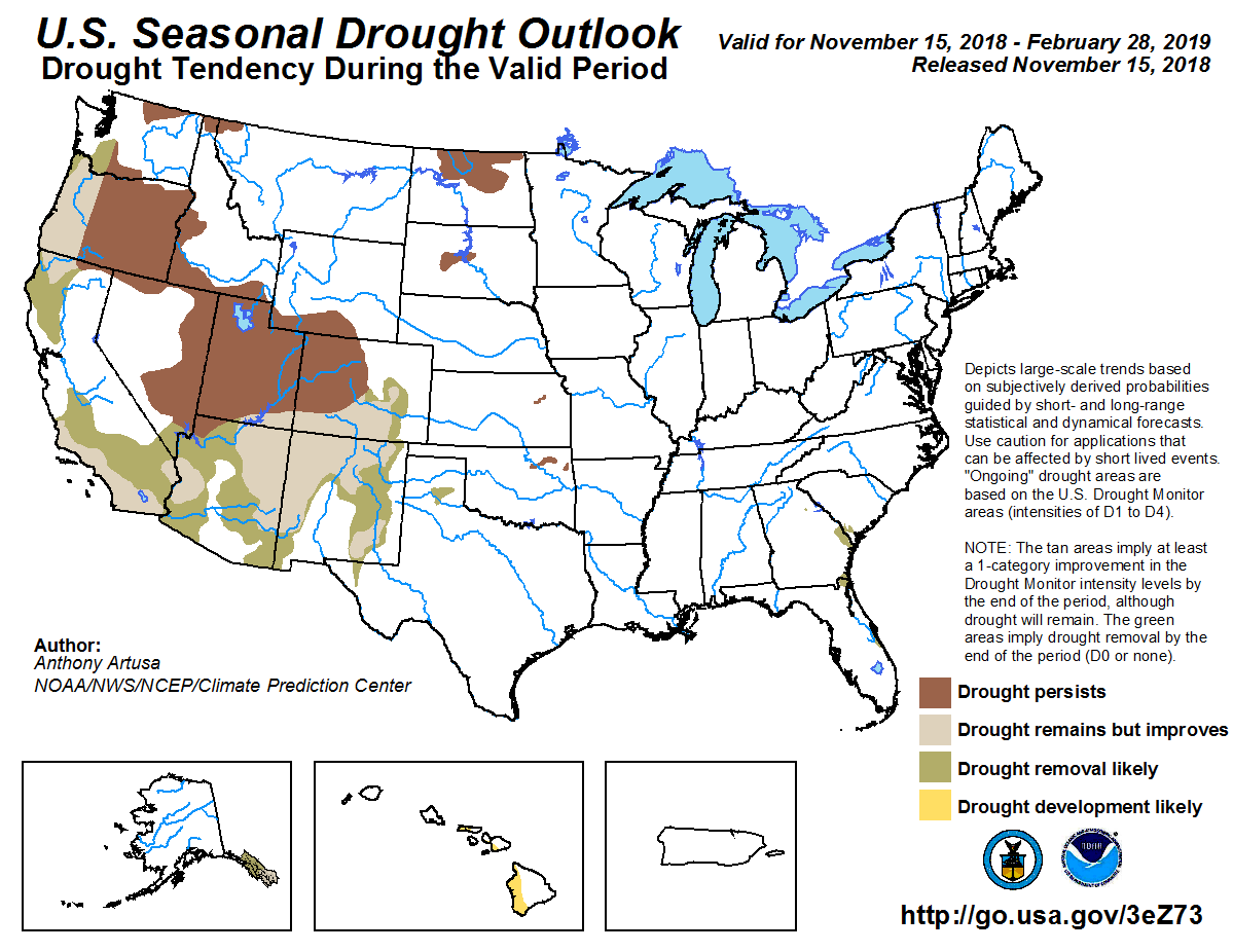
This U.S. Drought Monitor week saw improvements on the map across parts of the Southeast, Northeast, Northern Plains, the Rockies, and Desert Southwest. In the mountains of drought-stricken areas of Colorado and New Mexico, the cool-season is off to a positive start in portions of the central and southern Rockies where snow shower activity continued this week. In California, persistent dry conditions led to expansion of areas of drought in northern parts of the state where a dangerous and fast-moving wildfire broke out late last week in the Sierra Nevada foothills leading to destruction of the community of Paradise. The Camp Fire is now the most deadly and destructive fire in the state’s history and so far has resulted in the loss of 48 lives and destroyed 7,600 homes. In southern California, the Woolsey Fire broke out late last week and spread quickly across the Santa Monica Mountains because of dry vegetation and strong Santa Ana winds. The fire led to the evacuation of more than 100,000 residents in Los Angeles and Ventura counties and has been responsible for the destruction of >400 homes. In the Southeast, widespread rain shower activity helped alleviate areas of dryness in Alabama and Georgia while short-term precipitation deficits led to expansion of drought in portions of Florida…
On this week’s map, improvements were made in North Dakota with the removal of two areas of Severe Drought (D2) in response to normal to above-normal precipitation during the past 30-to-60 days. In northeastern Kansas, areas of Abnormally Dry (D0) and Moderate Drought (D1) were reduced in response to improving soil moisture conditions and above-normal precipitation during the past 60-to-90 days. For the week, the region experienced below-normal temperatures with the largest negative anomalies (12-to-24 degrees below normal) observed in North Dakota, northeastern Nebraska, and northeastern Wyoming…
In California, several dangerous and destructive wildfires broke out in both southern and northern California during the past week. In Butte County in northern California, the Camp Fire devastated the Sierra Nevada foothill community of Paradise – destroying nearly the entire community including 7,600 homes. According to CAL FIRE, the fire has burned in excess of 130,000 acres (35% contained) and has been responsible so far for the loss of 48 lives – making it the deadliest wildfire in California history. North of Los Angeles, the Woolsey Fire has burned 97,000 acres (40% contained) in and around the Santa Monica Mountains leading to the evacuation of more than 150,000 residents and destruction of >435 homes. Continued dry conditions in California led to expansion of an areas of Moderate Drought (D1) in the Sacramento Valley, extending to the western foothills of the northern Sierra Nevada. In the Rockies, widespread snow showers were observed in the Front Range and adjacent foothills as well as in the Sangre de Cristo Range, leading to improvements on the map in north-central and south-central Colorado. Overall, Colorado’s snowpack is off to a positive start with above-normal snow water equivalent (SWE) levels in the Front Range, Sangre de Cristos, and the Mosquito Range of central Colorado. In New Mexico, recent snowfall and above-normal SWE levels led to reduction of Extreme Drought (D3) in the north-central part of the state. In eastern New Mexico, recent storm activity and improved soil moisture levels have improved conditions leading to reduction in areas of Moderate Drought (D1) and Severe Drought (D2). In central Arizona, wet conditions during the past 90-days led to reduction in areas of Moderate Drought (D1). In the Northern Rockies near Glacier National Park, areas of Abnormally Dry (D0) were removed in response to above-normal SWE levels associated with recent snowfall. Average temperatures were below-normal across most of the region during the past week…
On this week’s map, only minor improvements were made in the region including removal of remaining areas of Abnormally Dry (D0) in northeastern and southwestern Mississippi where heavy rains this week erased existing short-term precipitation deficits. In the Texas Panhandle, areas of Abnormally Dry (D0) and Moderate Drought (D1) were reduced in response to improving soil moisture levels from snow shower activity in and around Amarillo. During the past 120-days, precipitation across Texas has been well above normal. For the week, average temperatures were well below normal with the greatest negative anomalies (9-to-15 degrees) observed in the Texas Panhandle and northern Oklahoma…
Looking Ahead
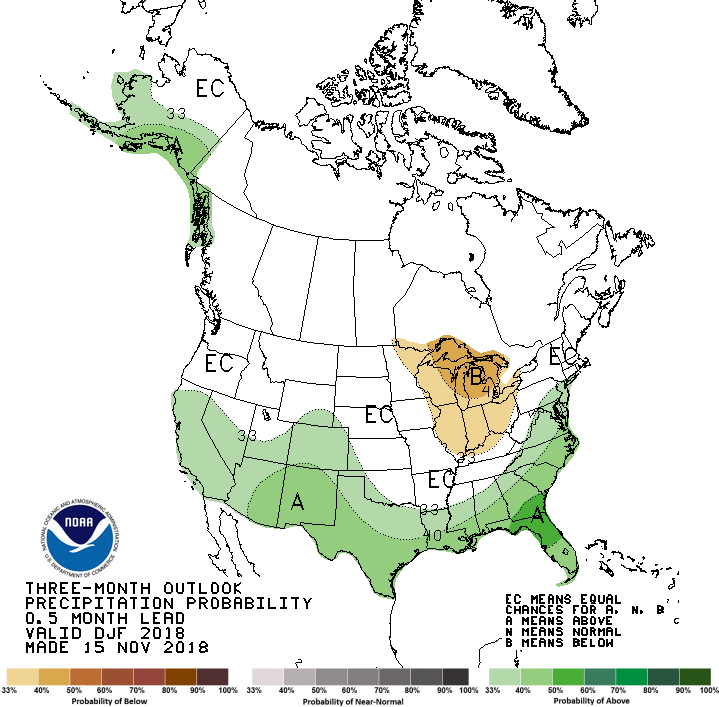
The NWS WPC 7-Day Quantitative Precipitation Forecast (QPF) calls for light-to-moderate accumulations ranging from 1-to-3 inches (liquid) along the Eastern Tier with the heaviest accumulations forecasted for portions of the Southeast and southern Mid-Atlantic. In the central and southern Appalachians, a wintry mix of rain, freezing rain, and snow is expected. West of the Mississippi River, conditions are expected to be dry with the exception of light-to-moderate accumulations in the Northern Rockies and western Washington. The CPC 6–10-day outlook calls for a high probability of above-normal temperatures across portions of the West including Arizona, California, Nevada, Utah, Oregon, and western Washington. In contrast, there’s a high probability of below-normal temperatures in the Midwest, Mid-Atlantic, and Northeast. In terms of precipitation, there is a high probability of above-normal precipitation across California, the western Great Basin, and Arizona while the Pacific Northwest and Northern Rockies are expected to be drier than normal. Moving eastward, above-normal precipitation is expected across Texas, the Gulf Coast, Southern Plains, and Florida while below-normal precipitation is expected in the Midwest, Mid-Atlantic, and Northeast.
The Northern Integrated Supply Project and the Windy Gap Firming Project, both projects managed by the Northern Colorado Water Conservancy District, have been decades in the making, and once they’re complete, they’ll result in three new reservoirs intended to address a growing Front Range population.
During the Northern Colorado Water Conservancy District’s fall water users meeting Wednesday in Fort Collins, officials took an audience through the progress of both projects.
The Northern Integrated Supply Project, which would affect Windsor and Evans, hit a major milestone in July after an Environmental Impact Statement was released.
“In 2019, we’re hoping for a really big, exciting year, in addition to the really big year we had this year,” said Stephanie Cecil, water resources project engineer for Northern Water.
The Windy Gap Firming Project, which would affect Greeley, is moving forward even as the project has been hit with a federal lawsuit.
In July, the U.S. Army Corps of Engineers released its final Environmental Impact Statement on the project — a process that took 14 years.
“It’s a really significant step in the project to be able to have all of those things done,” Cecil said.
Right now, the group is focused on design, particularly for the Glade Reservoir and the Galeton Reservoir. One pressing step in the project will be to relocate a section of U.S. 287 to allow for construction of the reservoir.
Additionally, the organization is working on mitigation projects, including one to help pass fish though a diversion structure and measure the amount of water the group is handling.
The group is also working on permitting with counties and the state, and developing a financing plan.
“How is this over $1 billion project going to be financed, and how is the construction schedule going to line up with the financing plan?” Cecil asked.
Construction could start by 2021, Cecil said, and the projects that will likely get started first are the Glade Reservoir and the U.S. 287 relocation. Cecil said the group hopes that the reservoir will be filled in 2026 and able to serve water in 2030.
“We’re looking at about a five-year timeline, but it’s dependent on weather,” she said. “Hopefully by 2026, we’ll have some really wet years and we can fill it really fast.”
[…]
A graphic from Northern Water showing the lay out of Windy Gap Firming Project.
The Windy Gap Firming Project, a collaboration between 12 northern Colorado water providers, including Greeley, will result in a new reservoir — the 90,000 acre-foot Chimney Hollow Reservoir — and the largest dam on the Front Range.
When it’s complete, the project intends to make water supplies more reliable by installing the reservoir west of Carter Lake in Larimer County.
For the past year, the project has been in the middle of a lawsuit filed by environmental groups against federal agencies. The lawsuit questions the need for the project, saying it would make significant water diversions from the Colorado River, and that the U.S. Bureau of Reclamation and U.S. Army Crops of Engineers did not have enough information before they issued initial permits to the district.
Still, Jeff Drager, director of engineering for Northern Water, said the project hasn’t been stalled by the lawsuit, especially because funding from the Natural Resource Conservation Service requires the group to use the money within the next five years…
Right now, the project is in the permitting process. So far, the organization has $11 million and is seeking ways to fund the final $4 million…
The project has been in the process of permitting the project for 15 years, Drager said…
Drager said the group hopes to start construction in 2021 or 2022.
The Sterling City Council — and those attending their regular Tuesday night meeting — got a lesson on Colorado water law and Sterling’s water supply this week.
Alan Curtis, a water attorney with White & Jankowski LLP, which has represented the city for 39 years, explained the basic tenets of Colorado’s water laws before getting into Sterling’s water rights and the pro-active approach the city has directed them to take in water cases. Curtis noted that over the past four decades, Sterling has taken part in over 180 water court cases and has gone to trial in only three, all of which ended with favorable outcomes for the city. Right now the city is involved in six pending cases…
Water engineers Jon George and Kristina Wynne of Bishop-Brogden Associates Inc. also spoke, giving an overview of the city’s existing water supply and augmentation plan. Wynne explained that in 2014, they developed a long-range plan to project the city’s future water needs. However, the last several years the city has not used as much water as projected, and she suggested that it would be appropriate to revise the long-range plan to make it more accurate going forward.
The three experts had some suggestions for projects the council should consider in the near future, including construction of a storage reservoir for augmentation.
They also noted that the city’s wastewater recharge pond represents an unknown. It has been an integral part of the city’s augmentation to offset its water use in the past, but for the past year the city has not been able to discharge wastewater to the pond because of violations of public health standards. If the city is unable to resume pumping to the recharge pond, it may need to develop other augmentation resources.
Recreation, in progress, on the Green River. Photo: Brent Gardner-Smith/Aspen Journalism
FromThe Grand Junction Daily Sentinel (Dennis Webb):
The Division of Water Rights last week heard from project proponent Aaron Million and from numerous entities that oppose it, before deciding to request more information from Million before a decision can be made.
Million, a Fort Collins resident, filed the Utah application through the company Water Horse Resources LLC, seeking to divert 55,000 acre-feet a year and pipe it east to Wyoming and then south to Colorado…
The idea is being opposed by federal agencies including the Bureau of Reclamation, National Park Service, Bureau of Land Management, and Fish and Wildlife Service. Other opponents include western Colorado’s Colorado River District, the Upper Yampa Water Conservancy District in Colorado, multiple water conservancy districts in Utah, conservationists, and notably the Utah Board of Water Resources and Division of Water Resources. That board works to conserve and develop the state’s water, and is worried that the proposal would let Colorado benefit at Utah’s expense…
Peter Fleming, general counsel for the Colorado River District, questions the project’s economic feasibility.
“Water Horse’s application has not shown that it has any significant committed recipients who are willing to pay for the water that’s supposed to be diverted,” he said…
The decision on Million’s water right application will be made by Utah’s state engineer, who heads the state’s Division of Water Rights.
Million said he thought the hearing went well and he’s awaiting a letter from the state engineer detailing what additional information is needed…
He said probably one-third or one-half of the 28 or so objectors didn’t show up at the hearing.
In the case of those who testified, “every point they made we’ve already looked at inside and out and so we’ll answer the issues related to the permit and move on,” he said.
A 30-day comment period will be provided after Million responds to the request for more information.
Ariel Calmes, a staff attorney for Western Resource Advocates, said in a news release after the hearing, “This application is the latest episode in Aaron Million’s decade-long effort to profit off of the private sale of Green River water. Million is proposing to divert water from Utah to the detriment of multistate water agreements, the recovery of endangered species, and millions of dollars in recreation spending.”
Northwater Treatment Plant — Denver Water is upgrading and modernizing the northern portion of its water system that was built in the 1930s. The utility is building a new water treatment plant, as seen in this rendering, installing a new pipeline, and redeveloping its Moffat Treatment Plant site. Photo credit: Denver Water
Here’s the release from Denver Water (Travis Thompson):
At its meeting today, the Denver Board of Water Commissioners adopted rate changes to fund essential upgrades and new projects to keep Denver Water’s system running smoothly. The new rates take effect Feb. 1, 2019, and monthly bills for most Denver residents will increase by 55 cents if they use water the same as they did in 2018.
“While the cost to maintain and upgrade the water system continues to increase, rapid development inside the city of Denver has brought in more fees from new taps sold, helping to minimize the 2019 rate increase for Denver customers,” said Jim Lochhead, Denver Water CEO/Manager. “The surrounding suburbs, however, had less development than in the past, reducing the amount collected from new tap fees, which means we’ll need to collect more revenue from suburban water rates in 2019.”
Suburban customers who receive water from one of Denver Water’s 65 distributors will see an additional monthly increase added to their volumetric charges. The Denver City Charter requires that suburban customers pay the full cost of service, plus an additional amount. Learn more about how this works: “Why Denver water costs more in the ‘burbs.”
If you live outside Denver and receive water from a distributor under contract with Denver Water, you can expect to see an annual increase between $23 and $41, which is between $1.90 and 3.40 a month (based on an annual use of 102,000 gallons of water).
Pat Fitzgerald, general manager of four Denver Water distributors including the Platte Canyon Water and Sanitation District and chairman of the suburban districts’ Technical Advisory Committee, which reviews Denver Water’s rates annually, provided this statement:
“The advisory committee supports the rate increase. The cost-of-service study used to determine the difference between inside city and outside city customers is fair and reasonable, and the committee had no objections to the results. The expenses are going up, but they’re all projects that are necessary to provide a reliable and safe source of water.”
The major multiyear projects that water rates fund include building a new, state-of-the-art water treatment plant, installing a new 8.5-mile water pipeline to replace a pipeline that was built in the 1930s, expanding Gross Reservoir to provide a more reliable future water supply, constructing a new water quality lab to ensure the highest water quality standards, investing more than $100 million to repair and replace water pipes, and more. There are 158 major projects identified in Denver Water’s five-year, $1.3 billion capital plan.
A customer’s bill is comprised of a fixed charge, which helps ensure Denver Water has more stable revenue to continue the necessary water system upgrades to ensure reliable water service, and a volume rate. The fixed monthly charge — which is tied to meter size — in 2019 is increasing by 55 cents for most residential customers both inside the city and out.
Denver Water’s rate structure includes a three-tiered charge for water use (called the volume rate). To keep water affordable, indoor water use — like for bathing, cooking and flushing toilets — is charged at the lowest rate. Essential indoor water use is determined by averaging the customer’s monthly water use on bills dated from January through March each year. This is called average winter consumption. Water use above the average winter consumption — typically for outdoor watering — is charged at a higher price.
Volume rates for Denver residents will remain the same, but will increase on suburban bills.
Denver Water operates and maintains more than 3,000 miles of pipe — enough to stretch from Los Angeles to New York — as well as 20 dams, 22 pump stations, 30 underground storage tanks, four treatment plants and more. The water provider’s collection system covers more than 4,000 square miles, and it operates facilities in 12 counties in Colorado.
Denver Water does not make a profit or receive tax dollars, and reinvests ratepayers’ money to maintain and upgrade the water system. The utility is funded by water rates, bond sales, cash reserves, hydropower sales and fees for new service (called System Development Charges).
Customers will see more information about 2019 rates in their bills and on Denver Water’s website over the next few months.
Gross Reservoir — The Gross Reservoir Expansion Project will raise the height of the existing dam by 131 feet, which will allow the capacity of the reservoir, pictured, to increase by 77,000 acre-feet. The additional water storage will help prevent future shortfalls during droughts and helps offset an imbalance in Denver Water’s collection system. With this project, Denver Water will provide water to current and future customers while providing environmental benefits to Colorado’s rivers and streams. Photo credit: Denver Water
Glen Canyon Dam on the Colorado River in April 2017. The dam is 15 miles upstream from Lees Ferry, Arizona. Photo by Alexander Stephens/courtesy Bureau of Reclamation.
From the American Planning Association (Allen Best):
Higher temperatures and lower water levels are causing states to rethink 20th century infrastructure.
The hundred feet of bleached sandstone walls of Glen Canyon exposed by the receding waters of Lake Powell starkly illustrates the conundrum of water infrastructure in western states and the effects of a changing climate. Completed in 1963, the construction of Glen Canyon Dam across the Colorado River in the Utah desert was a landmark in the resolute 20th century effort to harness rivers of the West to provide water for irrigation — and, indirectly, for expanding cities — and hydroelectric power for both.
Today, the dam delivers 1,320 megawatts of low-cost, low-carbon hydroelectric generation to farms and homes as far away as Nebraska. The reservoir, the nation’s second largest, is among 260 on the Colorado River and its tributaries that store and regulate flows in a vast plumbing system supporting a population of 40 million people from Denver to San Diego — cities outside of the river basin itself — and some of our nation’s most productive agricultural areas.
Population growth alone puts pressure on this 20th century infrastructure. Southwestern states grew 37 percent from 1990 to 2010, with no end in sight. Now comes clear evidence of climbing temperatures and hints at shifting precipitation patterns.
Lake Powell, as seen from Glen Canyon’s Carl B. Hayden Visitor Center observation deck. Photo by Alexander Stephens/courtesy Bureau of Reclamation.
Lake Powell, nearly full at the start of this century, is projected to end 2018 at 43 percent of capacity after another year of decreased runoff on the Colorado River. Subpar runoff has been more common than not this century, but unlike droughts of the past that were caused by reduced precipitation, some climate scientists say that warming temperatures have caused more than half the declined flows, due to evaporation and transpiration (when plants absorb water through their roots and then emit water vapor through pores in their leaves).
But Powell is just a chapter in a larger story. It is operated in tandem with Lake Mead, the nation’s largest reservoir, which is 300 miles downstream, below the Grand Canyon. Together, the two reservoirs can store 50 million acre-feet of water. (Smaller reservoirs in the seven basin states can store an additional 10 million acre-feet.)
But this overall bank account has been ebbing toward worrisomely low balances; this autumn, it receded to 28.4 percent of full capacity, among the smallest since the modern water infrastructure was completed last century.
Studying the numbers, some have raised the question of whether Lake Powell is needed at all and suggested that just Lake Mead will suffice in a hotter, likely drier Southwest of the future.
But adequacy of water infrastructure as the climate changes is not just a question for the Colorado River. It applies to the Columbia River of the Pacific Northwest, the Rio Grande of New Mexico and Texas, and California — all homes to giant water infrastructure. A nagging, and still unanswered question, remains: Will infrastructure created during the 20th century continue to serve the needs of the 21st century? And if the answer is no, what can we do about it?
Snowpack in the Watershed
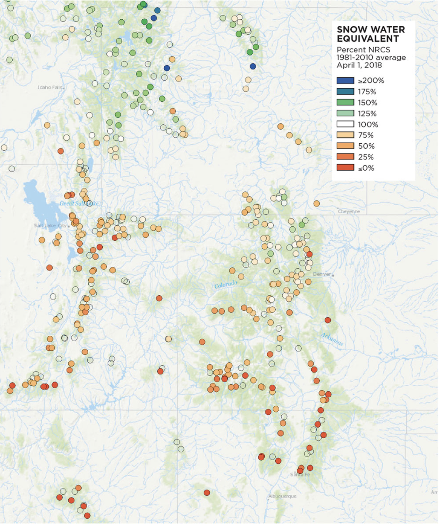
The snow percentile image displayed above indicates where the snow measurement ranks in the historical record (from 1981 to 2010) for each recording site as of April 1, 2018. Many sites are depicted with red dots, indicating the lowest values on record for this time of year. (via NRCS)
Changing times, temperatures
From beginning to end, cities, irrigation districts, and states ambitiously built dams, canals, and tunnels throughout the 20th century. The U.S. Bureau of Reclamation was the primary federal dam builder; its mission was to develop water storage and irrigation infrastructure to allow settlement of the arid western states.
Hoover Dam, completed in 1936, was a partial exception, driven by Los Angeles’s thirst for hydroelectric power, in addition to regulating flows for irrigation and controlling floods. In mid-century came the construction of Glen Canyon and other dams on the upper Colorado River Basin.
The last giant push, the Central Arizona Project, was authorized by Congress in 1968 but not completed until 1994. It delivers Colorado River water 337 miles through a concrete-lined canal to Phoenix and Tucson.
Today, rising temperatures threaten to upset the hydrological applecart. The U.S. Bureau of Reclamation, in a 2016 report to Congress, found that the western U.S. has warmed roughly two degrees Fahrenheit since 1895, compared to 1.3 degrees to 1.9 degrees F in other parts of the country. It will get worse, the report noted, with another five to seven degrees F of warming through the 21st century if greenhouse gas emissions go untamed.
This warming has profound consequences. Longer summers will demand more moisture for both lawns and crops; more rain will fall during winter atop snow, increasing the flooding potential for higher-elevation regions of the high Rockies by 200 percent, according to a study released in August; droughts will be deeper; and precipitation events when they happen, will be more intense.
Runoff patterns have already shifted. Spring comes earlier nearly everywhere — posing problems for water infrastructure in the West, which was mostly created with the assumption of a large snowpack that melts in the summer months. But a study by Oregon State University’s Philip Mote and others found that more than 90 percent of snow monitoring sites with long records across the western U.S. had dramatic declines in the water content of April 1 snowpacks. Altogether this loss, said the paper published in the journal Nature, was comparable in volume to the water in Lake Mead.
“The magnitude of these changes relative to the built storage reservoirs, and the certainty with which continued warming will lead to continued declines at a similar or increasing rate, illustrates the immense challenge facing Western water managers,” Mote wrote.
Mote’s report warns that those solutions will likely require some heavy lifting by water managers and public officials. “Patterns of water use that became established (even entrenched) during the climate of the past cannot be changed without intense political effort owing to large cultural, economic, and infrastructure investments in the status quo ante. … Solutions will have to lie primarily in the linked arenas of water policy (including reservoir operating policies) and demand management.” (For more an overview of demand management policies, see “Water Pressure,” August/September 2018.)
“We need to do a much better job of integrating [this] new reality into our water management decisions,” says Heather Cooley, director of the water program at the Pacific Institute in Oakland, California.
Shrinking Water Levels in Lake Powell
Changes in the northeastern reaches of Lake Powell are documented in this series of natural-color images taken by the Landsat series of satellites between 1999 and 2017. The Colorado River flows in from the east around Mile Crag Bend and is swallowed by the lake. At the west end of Narrow Canyon, the Dirty Devil River joins the lake from the north. (At normal water levels, both rivers are essentially part of the reservoir.) At the beginning of the series in 1999, water levels in Lake Powell were relatively high, and the water was a clear, dark blue. The sediment-filled Colorado River appeared green-brown. To see the complete series go to: earthobservatory.nasa.gov/WorldOfChange/LakePowell. Photos via NASA
New approaches
Higher rates of evaporation caused by warmer temperatures have played into current conversations about water infrastructure, including the debate about Lake Powell. Environmentalists never did like that the reservoir inundated 186 miles of lovely rust-colored canyons. In 1975, even before the reservoir had filled, Edward Abbey had mischievously imagined the dam fracturing in his novel The Monkey Wrench Gang. Critics say that the reservoir has made the Colorado River through Grand Canyon National Park a beautiful and sometimes dangerous irrigation ditch.
Arguments in recent years have pivoted more on climate change. Given the declined flows in the Colorado River Basin, could one reservoir — downstream at Lake Mead — suffice? A canyon could be restored and there would be evaporation from just one reservoir, not two. An average six feet of water per year evaporates from the surface of Lake Powell, a little less than downstream at Lake Mead in the Mojave Desert.
Dan Beard, a former commissioner of the U.S. Bureau of Reclamation, has emerged as the most prominent advocate for removing Glen Canyon Dam. The dam, he says, was conceived during a different time. “Seventy-five years ago, there were no American environmental laws to protect the Colorado River, the science of climate change did not yet exist, and the flow of water in the Colorado River was much higher,” he wrote in an op-ed published a few months ago in the Denver Post.
“There is no new water to fill these facilities, and there won’t be because of the inevitable impacts of climate change,” he wrote.
Evaporation is also an issue in New Mexico. The state’s largest reservoir, Elephant Butte, located in the desert south of Albuquerque, serves as primary storage for the Rio Grande. Climate projections point toward a much hotter and drier future for the river basin. Might that future better be served by more reservoirs in higher-elevation and cooler locations, such as at the river’s headwaters in Colorado? That idea was proffered by U.S. Sen. Tom Udall — whose father and uncle were influential in creating this 20th century infrastructure — at a conference in Santa Fe this past spring.
With river flows declining, there have been calls for more storage. But nobody realistically expects another Grand Coulee in the 21st century. The good sites for dams have been taken, and the environmental impacts are better understood, or at least more strongly argued.
Anne Castle, who was the Interior Department assistant secretary for water and science in the Obama administration for five years, sees value in “small strategic storage that will allow more efficient utilization of the water we have.” In some cases, this merely requires retrofits. She cites the example of Fontenelle Reservoir, located in southwestern Wyoming.
Loose stones, called rip-rap, were originally used to fortify the upper portion of the Fontenelle Dam, making it more resistant to erosion from waves, but not the lower portion (largely because the dam’s designers never expected water levels to get that low). That means water levels cannot currently be drawn down below the reinforced section, limiting the amount of usable water storage. To remedy this in the likelihood of worsening drought conditions, the state wants to reinforce the lower part of the dam wall.
“You can get a lot more usable storage without having to build anything new,” says Castle.
Groundwater recharge takes the burden off surface storage, says the Pacific Institute’s Cooley, allowing reservoirs to be used more for flood control. “Groundwater recharge also diminishes water lost to evaporation. It will help us deal with more extremes in the future,” she says.
Cooley also says dispersed and smaller water storage would be more resilient in case of natural catastrophes, such as earthquakes. And in California and elsewhere, demand-side management and conservation programs can be leveraged even more to make communities less reliant on big water projects. For example, while some state and local water laws limit water reuse, San Francisco now requires all buildings of 250,000 square feet or more to institute water reuse within the building.
Not every strategy is appropriate in every location, Cooley says, and none of them are particularly easy. “But I think they will be necessary to meet our 21st century challenges.”
Divers and marine operations specialists perform an inspection at Fontenelle Dam in Wyoming. Photo by Alexander Stephens/courtesy Bureau of Reclamation.
Who will foot the bill?
Beyond the question of what infrastructure makes sense in the 21st century, there’s also the question of who will maintain aging dams, canals, and other delivery systems. The federal government and its generous piggy bank largely disappeared after the dams were built. Castle, the Washington veteran, doesn’t assume that “federal investment in water will never go up again.” But neither is federal aid certain.
That question of funding faces Colorado’s Mark Harris, the general manager of the Grand Valley Water Users Association. The association administers a small diversion dam on the Colorado River built in 1916, along with 55 miles of canal and 150 miles of pipe and smaller ditches, called laterals. This infrastructure delivers irrigation water to 23,340 acres of vineyards, peaches, and other agricultural products around Grand Junction. Increasingly, this water gets transferred to new suburban and exurban homes.
Harris says Grand Valley’s water customers mostly accept the challenge of climate change, recognizing that existing infrastructure, in addition to being a century old, may not entirely be adequate for changing pressures. But new concrete and reconfigured headgates are not the only issue.
“We have 19th century (water) laws, 20th century facilities, and 21st century expectations,” Harris says. Physical infrastructure is not the only thing that must be updated, he says. “There is also the rehabilitation and evolution of our thinking.”
California provides a case study because of its wild extremes: drought from 2011 to 2014 that was deeper than any in the state’s recorded history followed by a winter in 2016–2017 that, in the state’s northerly sections, was the wettest ever.
“These changing conditions threaten an already deteriorating infrastructure system, which traditionally has been planned, designed, and engineered based on historical climate and weather data and trends on the assumption that the past is a good predictor of the future,” reads “Built to Last,” a December 2017 report about California water infrastructure by the Union of Concerned Scientists.
The scientists call for “climate-smart” infrastructure as California spends the $7.5 billion for various water projects approved by voters in 2014. (Voters this month will be asked to approve another $9 billion bonding capacity). There have been proposals for more big dams, but they have lost out to small storage, including aquifer recharge projects.
Beard, the now-retired boss of federal dams who supports tearing down Glen Canyon Dam, says water solutions for western communities need to be more local. It starts, he says, with realistic prices being assigned to water. In many cases, water now is essentially free. We pay for its transportation, but not for the water itself. He further points out that many water proposals even during the 20th century, such as making dams higher, faltered when those who would benefit were asked to pay.
The answers for both population growth and climate change, he says, lie closer to home, not in trying to tap new resources far away.
Allen Best writes about water in the Great Plains and western states frequently from a base in Denver. He can be found at http://mountaintownnews.net.
Tuesday, the Colorado Springs City Council unanimously approved the 2019 budget and rates for Colorado Springs Utilities customers.
The city said local water and wastewater systems are old and in need of ongoing repair and refurbishment.
According to the city, the typical residential wastewater customer will see an increase of about $0.88 per month. The city said this increase, the first since 2010, is largely due to inflationary costs…
Typical residential water customers will experience a monthly increase of $3.80, according to the city. This funding supports a “significant” upgrade to the Phillip H. Tollefson Water Treatment plan, as well as work to repair water mains, according to the city.
The city also said that most commercial and industrial customers will also experience increases to base rates for wastewater and water services.
Springs Utilities has an online bill calculator available to see how these changes will affect individuals and commercial customers. An Understanding Your Bill video is also available to assist customers.
Sunday’s snowstorm was quite impressive! Some areas in the Pikes Peak region and the mountains southwest of Pueblo piled up a foot of snow. People we interviewed had mixed feelings about the winter weather, but ultimately loved the moisture…
But just how much does this recent snow affect our snowpack and drought? While statewide, our snowpack numbers are down compared to what we’ve experienced recently, across Colorado, we are 126 percent above-average snowpack levels. That’s great. The Arkansas River basin is more than 160 percent of normal in snowpack. This is fabulous news for our state’s water resources, not to mention favorable conditions for skiers and snowboarders in the high country.
In terms of our drought, it’ll take consistent snowstorms to see a noticeable improvement. One storm isn’t enough to eradicate extreme or even moderate drought. Even still, it’s wonderful to see that recent moisture. Our next updated drought monitor will be released this Thursday.
It’s incredibly important to see good snow in the winter season to mitigate fire danger which tends to increase in the spring. With an El Niño pattern still expected to develop in the coming months, we could be dealing with more active weather this winter season.
I am so grateful to the people of Arizona for allowing me the opportunity to continue serving as governor of our great state. I am humbled by your confidence and ready to continue working for you. And there’s a lot of important work to do.
As I traveled the state during this campaign – from Mohave County to Cochise County, and everywhere in between – one of the most frequent topics of discussion mentioned by constituents was the important issue of securing our state’s water future. It is clear that Arizonans understand we must make important decisions regarding the management of our scarce water resources. In the face of ongoing drought on the Colorado River, the time to reach responsible and nonpartisan solutions is now.
The solution proposed by Arizona, California, Nevada and the federal government is the Drought Contingency Plan (DCP). This plan will help protect Lake Mead from declining to critically low levels that would cause potentially catastrophic reductions to Arizona’s Colorado River water supplies.
DCP lessens the likelihood of such reductions by imposing prudent reductions earlier and incentivizing water users to leave water in Lake Mead. Mexico is also stepping up with a parallel plan.
Implementing DCP in Arizona will require compromise from every stakeholder. This means setting aside narrow special interests and working for the good of the entire state.
My administration, the Legislature, and stakeholders have been working hard to reach an agreement on how to respond to the impacts of those reductions.
Although those efforts have been productive, some recent proposals are so short-sighted and unsustainable that it requires me to remind all participants why we began this process in the first place.
The foundational purpose of a multi-state drought contingency plan is to transition to a drier future. That transition may warrant a modest amount of mitigation for the increased reductions that would be imposed under DCP. However, in recent stakeholder meetings, demands for water and money to mitigate reductions are growing to insurmountable proportions – more than 1 million acre-feet of water and over $200 million through 2026 – creating an unsustainable precedent for mitigating water reductions in the future.
That is not sound long-term planning, and the people of Arizona expect more from us.
To secure Arizona’s water future, we must prioritize conservation, augmentation and innovation. The plan to implement DCP must adhere to some key principles.
First, we need to reaffirm Arizona’s goal of conserving water to raise and protect Lake Mead elevations. Arizona water users have invested considerable resources in conserving more than 350 trillion gallons of Colorado River water since 2014, raising Lake Mead elevations over 13 feet. Any plan to implement DCP in Arizona must build on those efforts.
Second, we must recognize that drought may be the new normal and that DCP is only an interim measure; our State must preserve long-term resources to address anticipated water supply challenges well into the future.
Third, our actions now should not establish expectations that reductions in Colorado River supply will be mitigated forever.
Finally, we take the broad view. We recognize the need to address impacts on certain water use sectors, but individual interests must be appropriately balanced against the interests of the State as a whole.
It’s time to get to this done and make DCP a priority by working together to find sustainable, long-term solutions to address the challenges we face on the Colorado River. And Arizonans should rest assured — DCP will need to be part of a traditional legislative process, and I will not sign a bill that does not adhere to these important principles, or any bill that does not adequately help to secure our state’s water future.
Arizona has a long history of arriving at such solutions with future generations in mind. We have a rich, legacy of coming together where our water resources are concerned. Arizonans expect us to follow in this tradition — and they expect us to act now.
Gov. Doug Ducey was re-elected to his second term in office on Nov. 6, 2018.
Here’s the release from Aurora Water (Greg Baker):
Water rights purchase provides environmental benefit
Aurora Water has finalized the purchase of water rights associated with the London Mine, located near Alma, in Park County. 1,411 acre feet (af) of water has been acquired at price of $22,000 per af, with additional costs of $2 million for an option to acquire additional water rights as they are developed and $1M for an easement. An acre foot of water is 325,851 gallons, enough water to serve 2.5 households on average. The seller of the rights is MineWater Finance, LLC and No Name Investors, both Colorado companies. The total value of this initial purchase is $34,042,000. The sellers are confident that the source of the rights could ultimately result in additional water that Aurora has the exclusive option to purchase for $21,500 per acre foot.
The source of this water is from a basin that is recharged from snowmelt on London Mountain. A geologic fault contains the water underground and prevents it from discharging into South Mosquito Creek, a tributary of the South Platte River. This water is pumped from the basin to a water tunnel in the London Mine and from there, discharged into South Mosquito Creek, which is upstream of Aurora’s Spinney Mountain Reservoir. Since this water is not naturally connected to the streams, it is decreed under Colorado Water Law as non-tributary. This has special meaning as this water is fully reusable and can be recaptured utilizing Aurora’s Prairie Waters system, a potable reuse system.
Aurora Water has been a national leader in water efficiency, including an acclaimed Prairie Waters water reuse system, and a nationally recognized water conservation program. Water acquisition is still necessary to meet future demands.
“Looking for new water supplies in the arid west requires innovative thinking,” said Marshall Brown, Director for Aurora Water. “This is a supply that historically has not been tapped by water providers, but the easier supplies are gone.”
The environmentally positive aspects of purchase have resulted in praise from organizations such as the Boulder-based Water Resource Advocates (WRA).
“New water supplies in Colorado are extremely limited and, at the same time, nearly 2,000 miles of streams in Colorado are polluted by mines,” Laura Belanger, Water Resources and Environmental Engineer with WRA stated. “We commend Aurora Water for taking a leadership role in finding this inventive and environmentally beneficial solution to meeting its customers’ water needs.”
Aurora Water completed substantial due diligence prior to this initial closing. Additional water rights under the option provision will be purchased as they are adjudicated and decreed through Colorado’s Water Courts.
Aurora Water is only purchasing the water rights. MineWater will continue to be responsible for the mine property, wells and associated permits. Questions regarding the mining operations, including the permits, should be directed to the MineWater contact listed above.
Click here to read the London Mine Purchase and Sale Agreement Fact Sheet.
Click here to read the mine water attachments to the release.
From 1874 until the 1940s, the London Mine was one of the top-producing gold mines in the state. It also produced lead, silver and zinc. In 1991 the mine eventually closed, but a fault within the mountain created a natural reservoir, one that fills with snowmelt.
In the nearly three decades since the mine has been closed, the state health department and U.S. Environmental Protection Agency have had their eye on the mine and its previous owners. In 2009, 2011 and 2013 CDPHE cited the mine for violating the discharge permit. A treatment plan for the mine was created, but it failed. And in 2016 CDPHE slapped the owner previous to MineWater with a $1.1 million fine.
Water officials and MineWater have studied the water, and will continue to do so, to make sure it’s a safe source.
MineWater, which has completely reworked the plumbing of the mine, will still continue its operations and hold all mine permits. Aurora water is only purchasing the water rights.
Click on a thumbnail below to view a gallery of snowpack data from the NRCS. Please note that most of the High/Low graphs have not updated since Friday and I could not locate the one for the Rio Grande. The basin-filled maps are from this morning.
Yampa and White Basin High/Low graph water year 2019.
South Platte River Basin High/Low graph water year 2019.
Laramie and North Platte Basin High/Low graph water year 2019.
Gunnison River Basin High/Low graph water year 2019.
Arkansas River Basin High/Low graph water year 2019.
Upper Colorado River Basin High/Low graph water year 2019.
San Miguel, Dolores, Animas, and San Juan Basin High/Low graph November 13, 2018 via the NRCS.
Statewide Basin High/Low graph November 13, 2018 via the NRCS.
Westwide SNOTEL basin-filled map November 13, 2018 via the NRCS.
Like much of the West, Northwest Colorado saw one its most epic and most expensive wildfire seasons to date in 2018. The region is accustomed to dealing with lots of fires, but this year’s extreme heat and drought resulted in more volatile fires that consumed vastly larger numbers of acres than in years past.
“It was the busiest year we’ve had in the last 10 years, by far,” said Colt Mortenson, fire management officer for the Bureau of Land Management’s northwest region. “Usually, you get a fire, you get a rest, and then another comes up. It pulses. But this year, it didn’t pulse. It began about the 20th of June and lasted straight through until October.”
A total of 229 fires charred more than 108,000 acres across Moffat, Rio Blanco, Routt, Jackson, and Grand counties, according to Mortenson, including some acreage burned across the border into neighboring Wyoming and Utah. That is nearly twice the acres that burned last year and more than any fire season in the past 20 years. In Moffat County, alone, more than 23,000 acres burned, most of them in the 19,955-acre Divide Fire north of Craig.
The fires strapped both local and national resources, destroyed grazing lands and sage grouse habitat, and cost local, state, and national agencies lots of money.
“Without question, this will be the most expensive wildland fire season Moffat County has experienced,” said Sheriff KC Hume.
Hume estimates that fires like the 4,100-acre Bender Mountain Fire, which burned from Utah into Colorado in September, and the 8,610-acre Boone Draw Fire cost several millions of dollars each.
Some fires are more expensive than others though, noted Mortenson.
“When you have fires burning in forest, like the Ryan Fire and Silver Creek Fire, (which) burned for up to 100 days … those are really, really expensive fires,” he said. “I’d say we easily spent over $30 million with the Ryan Fire and Silver Creek Fire,” which burned 28,585 acres and 20,120 acres, respectively, in the Medicine Bow-Routt National Forest.
Firefighting costs are complex and split across multiple levels of government depending on whether a fire burned on private, state, or federal land. The Moffat County Sheriff’s Office is responsible for fighting fire on private and state land and shares that load with Craig Fire/Rescue, which is responsible for a 180-square-mile district.
Moffat County Road & Bridge provided nearly 2,500 man-hours of firefighting support on 13 fires this summer, of which about 840 hours were overtime.
“We’re at 108-percent of our overtime for the year,” said Ken Moncrief, motor grader supervisor for Road & Bridge. “Typically, our overtime would go for snowplowing … but the fire season is pretty much the culprit for eating up our overtime budgets. It hit us a little harder this year than it has in the past.”
The county often sends motor graders and dozers to help dig firelines and provides water tenders, when needed. Some of those hours may be reimbursed by state or federal agencies, but a significant portion will remain the county’s responsibility.
The Craig-Moffat County Airport also played a key role in firefighting efforts this summer with the addition of two new helipads for firefighting helicopters, as well as functioning as a base for single engine air tankers, or SEAT.
“Out of the Craig SEAT base, we flew over 400,000 gallons of water, thermal gel, and retardant, which is a record amount at least for the last 20 years,” Mortenson said.
The reason behind so many record-breaking numbers in this year’s fire season is a weather year that also broke records. Most of Moffat County experienced the hottest year on record for the 2018 water year, according to a report from the Colorado Climate Center at Colorado State University, as did most of Northwest Colorado and the Western Slope. Conditions were also extremely dry, with a slice of western Moffat County claiming its driest year on record.
“Now, a lot of people are talking about how our fire season has gone from 100 days to 150 days. It’s getting warmer and seems to be getting drier,” Mortenson said. “The number of fires we’ve had in the last 20 years has increased, and the severity of the fires has increased.”
Lightning is usually prolific across Moffat County in summer, with as many as 8,000 lightning strikes in a single night in years past, Mortenson said. While lightning strikes were fewer than normal this year, they started even more fires, because they were met with extremely dry vegetation on the ground, he added.
“Usually, we spot a fire or get a report and have time to get an engine out there, but within 20 minutes, it was off and going,” he said. “This year, they just moved on us.”
The majority of fires in 2018 were lightning-caused, but nearly a third were human-caused, according to statistics from the Craig Interagency Dispatch Center.
Two homes were destroyed in the Divide Fire, and it left its mark upon residents and ranchers in other ways, as well. Miles upon miles of agricultural fencing burned, as did grazing land. Cattle rancher Wes McStay was one of several ranchers who felt the sting; about 1,800 of his own acres burned in the Divide Fire, as well as 500 acres of permitted BLM grazing lands and at least eight miles of fencing.
“It’s $10,000 to $12,000 a mile to replace it. It hurts,” McStay said, noting that it was a tough summer all-around for him and his neighbors due to drought. McStay has also had to resort to buying expensive feed and hay to make up for the losses. “This is the worst I’ve ever seen it, the hottest and driest I’ve ever seen it. Everybody struggled, not just us.”
McStay also lamented wildfire’s impact on sage grouse. The Divide Fire consumed some of Moffat County’s prime sage grouse habitat, including a field on McStay’s property that was home to the state’s largest sage grouse lek, or mating ground.
“I’ve been working on this sage grouse thing for the last 20 years, and much of what I’ve done just went up in smoke. It’s disappointing,” McStay said.
A total of 38,100 acres of sage grouse habitat burned in Northwest Colorado this year, most of it priority habitat, accounting for more than a third of the acreage that burned in the region.
“The challenge with sage grouse habitat is that invasive annual grasses can replace the sagebrush,” said BLM spokesperson David Boyd in an email. “Also in areas where habitat is limited, there may not be many areas for birds displaced from a large fire to go.”
There were no major closures to hunters in the area due to fire this year, said Bill DeVergie, area wildlife manager for Colorado Parks & Wildlife, based in Meeker. He did express some concern, however, for how big game populations will fare this winter.
“A couple of the big fires were further west on the winter range, so there will probably be less forage available,” DeVergie said. “It depends on what kind of winter and how much snow we get, but it could make it difficult for them to find food.”
Nonetheless, the ecological costs of fire are often eventually outweighed by the benefits, when new growth in the landscape emerges in the years to come. Meanwhile, the exact dollar costs of the 2018 fire season won’t be known until next spring, when the state completes a complex set of calculations and sends out bills to the different agencies responsible, including the Moffat County Sheriff’s Office.
“We had more wildland fire than we’ve ever had, and we spent more money than we ever have,” Hume said of 2018. But, “we have an extremely robust wildland fire suppression group. … I honestly believe that we do wildland fire better than many areas because of the relationships that we have here.”
Contact Lauren Blair at laurensblair@gmail.com or follow her on Twitter @LaurenBNews.
Thornton leaders plan to lend up to 3,000 acre-feet of water to the ailing Poudre River.
The effort is part of a long-term plan to create a virtual barter market on the Poudre, where cities, farmers and ditch companies can lend their water rights to a stretch of the river before taking it back at a downstream point. Thornton is working with Fort Collins, Greeley, Northern Water and other stakeholders on the so-called Poudre Flows project.
The Poudre Flows project still needs sign-off from Colorado’s water court. Thornton leaders and other stakeholders previously told the Coloradoan they’re planning to carry out the project without infringing on other people’s water rights.
FromThe Glenwood Springs Post Independent (Thomas Phippen):
The Hot Springs Connection held its inaugural meeting in Glenwood Springs Wednesday through Friday. Organized by [Vicky] Nash, who founded tourism data marketing firm Resort Trends Inc., the aim of the conference was to gather owners and operators to share knowledge and build a network to help each other.
“The group really wants to form an industry association so they have a network of people they can communicate with. We’re going to start that process,” Nash said. She plans to work with association managers to begin the process of setting up the board and bylaws.
Nash will also move forward with a website to list every hot springs resort in North America. The site will likely have a buy-in for resorts to add additional information beyond a basic listing on the site.
“Why reinvent the wheel? Someone said that yesterday, and it’s true. We’re all dealing with similar issues,” Mike Sommer, who is assisting South Dakota hot springs owner Kara Hagen renovate a resort that has been defunct since the 1940s.
Each place where heated water bubbles up to the surface is an opportunity for something unique.
In Glenwood Springs, that variety exists in a few square miles — from the sulfuric vapor of the Yampah caves, which the Los Angeles Times once described as something out of Dante’s “Inferno,” to the largest hot springs pool in North America filled with water from the Yampah that functions as a community gathering place, to the aesthetic soaking pools in view of the Colorado River at Iron Mountain.
HOT TOWN TOUR
The owners of the three principal hot springs resorts in Glenwood — the Hot Springs Pool, Iron Mountain Hot Springs and the Yampah Spa and Vapor Caves — led the attendees through the back-end of their businesses to show how the mineral-rich water gets from the ground to the guests.
The diversity is good for the industry because it limits how much each resort competes with another, but it also means there are numerous ways to design and create the thermal springs resort, and that can be daunting for the newcomer…
LOBBYING SUPPORT
One thing Seibel hopes to see from an association of thermal springs owners is help in educating the public, and even lawmakers, about hot springs.
Legislators are “putting out laws that are very restrictive, but they don’t understand what is happening,” Seibel said.
Each state has different laws, and a trade association could help owners navigate the regulations, he said.
The big pool at Glenwood Hot Springs and the family pool at Iron Mountain must be chlorinated. Colorado statutes require water to be treated unless it completely cycles through a pool in two hours or less — as the 16 hotter soaking pools at Iron Mountain are set up to do.
At the Glenwood Hot Springs pool, manager Brian Ammerman told the group about the challenges of keeping the big million-gallon pool of water at a consistent 92 degrees.
Each hour, the operators take the temperature of the gravity-fed filter tanks and calculate how hot the water needs to be to keep the pool at the desired temperature. “You open up a little cold, a little hot, it’s all feel,” Ammerman said.
Central Arizona Project map via Mountain Town News
Many Indian reservations are located in or near contentious river basins where demand for water outstrips supply. Map courtesy of the Bureau of Reclamation.
At Colorado Mesa University’s Upper Colorado River Basin Water Forum [November 7-8, 2018] in Grand Junction, a distinguished panel of the Colorado River Basin brain trust cheerfully dodged an audience question about what the basin states’ Plan B is if Arizona can’t come to the internal agreement needed to sign on to a Colorado River Drought Contingency Plan.
“Arizona will figure it out,” said Chris Harris, Executive Director of the Colorado River Board of California.
With no one from Arizona on the panel to speak for themselves, it’s probably the best answer Harris could have given to an unfair question. Clearly the representatives of the federal government and the other six Colorado River Basin states can see what the rest of us can see regarding Arizona’s difficulties in coming to agreement on how to reduce water use to meet their obligations under the DCP. And they’re smart people, which means we have to believe they’ve thought about what a six-state, Arizona-less DCP might look like. But it would be unwise at this point to talk about it publicly.
Abigail Sullivan of Indiana University and colleagues published a fascinating new paper looking at Arizona’s DCP process that sheds some light on the current situation. It helps explain why a) Arizona’s current efforts to come to an agreement on a DCP have run aground, and b) why there’s reason to be optimistic that Harris’s answer to the question during the Grand Junction conference is ultimately probably the right one, and we won’t have to worry about how Plan B might work.
Sullivan and colleagues identify a window of opportunity that opened in 2016 “tied to declining Lake Mead elevations and perceived harm associated with inaction”. At the time, Arizona was staring at a formal shortage declaration that would have forced mandatory reductions in its supply of Colorado River water. And at the time, it appeared Arizona was on board with the complex shortage-sharing provisions in the DCP, which would importantly for the first time bring California voluntarily into the “we’re all gonna use less Lower Basin water” club.
And then the snows fell, and the window of opportunity closed:
“After continuing to decline throughout 2015 and 2016, increased winter precipitation in 2016–2017, combined with ongoing conservation efforts, raised Lake Mead’s elevation to 1089 feet in March 2017. After the period of increased precipitation in early 2017, evidence of short-term thinking related to the DCP emerged. In 2017, there were numerous instances of stakeholders planning or making decisions based on weather, as opposed to climate.”
Interesting letter from the Central Arizona Water Conservation District board leadership regarding Colorado River Drought Contingency Plan. Not sure what this means, seems kind of important. I guess we all need to set aside some time on Nov. 15 to find out.
“Please be advised that the Board of Directors of the Central Arizona Water Conservation District is holding a special meeting on November 15, 2018 to discuss a number of matters related to the Drought Contingency Plan in preparation for significant decisions that the Board may take up as soon as the December 6, 2018 regular Board meeting. We anticipate that a DCP Mitigation Proposal will result from the Board’s November 15 discussions, which we, the undersigned, as Delegates to the Arizona DCP Steering Committee, would like to present to the Steering Committee as soon as possible thereafter.”
Here, from the solution space, a proposal from Arizona’s Colorado River Indian Tribes to help Arizona reduce its use of the river’s water. The CRIT have some of the bestest most senior Colorado River water rights in the state:
“Attached to this letter is the proposal from the Colorado River Indian Tribes for System Conservation and Intentionally Created Surplus to assist the State of Arizona in its effort to adopt the Lower Basin Drought Contingency Plan.
“We live on the Colorado River. The River runs through the middle of our land. We understand the risks to the River with continued drought throughout the Basin. Our proposal is to protect the life of the River. We believe that adopting the Drought Contingency Plan by all the Basin States, including Arizona, is the best way to protect the River during the decades?long drought, as temperatures rise and our climate changes.
“We have been working with Reclamation and your respective staffs over the last few months to prepare a proposal that will make a difference for this process. This proposal is one that we know we can fulfill, and that Reclamation can verify. The attached documents detail our plan to make 50,000 acre-feet of water available for Compensated System Conservation each year for three years beginning in January 2020 for a total of 150,000 acre?feet of water. in addition, we will agree to forebear from increasing our consumptive use on the Reservation above an agreed upon baseline. This will provide the CAWCD with increased certainty about the supply available for use in Arizona. We are also creating up to 20,000 acre-feet of intentionally Created Surplus in our name to be used as a buffer for our on-reservation water use when the Overrun and Payback Policy is suspended during shortages.
“The Tribes are asking for $250 an acre-foot for the Compensated System Conservation portion of the proposal. This does not reflect the economic value of CRIT water for farming on our reservation or the value of the number one priority water in the Lower Basin. However, we are willing to accept this price in order to assist with the Drought Contingency Plan to protect the River.
“Our water right does not best serve the State of Arizona by placing it in Lake Mead as System Conservation. The value of our water will be realized when we have the Congressional authorization to make a portion of our water available for off-reservation uses within the State of Arizona and preserve the first priority of our right during shortages.
“We look forward to working with Governor Ducey and our Representatives in Congress to pass
the federal legislation necessary to make this happen.”
Approximately 19 years of drought in the Colorado River basin have led the seven states that rely on water from the river and its tributaries to look at ways they can avoid severe water crises.
That could have major impacts for San Juan County residents, according to Rolf Schmidt-Petersen, who serves as the bureau chief for the Colorado River basin for the Interstate Stream Commission.
“The issue that we’re talking about today and the plans that we are talking about today are very important for the Upper Colorado basin,” said Schmidt-Petersen during a San Juan Water Commission meeting on Wednesday…
That potential [pre-1922 call] could impact many water rights in San Juan County. Schmidt-Petersen cited the Navajo-Gallup project and the water rights in the Hammond area near Bloomfield as some of the post-1922 water rights.
The potential challenges the seven states that rely on the Colorado River could face in the future led to the two basins drafting drought contingency plans, which were released in October.
The upper-basin plan has two aims — ensuring the water level in Lake Powell does not drop below a certain point and developing a system for storing water in certain reservoirs, including Navajo Lake.
Schmidt-Petersen said Navajo Nation was not included in the process of drafting the plan.
FromArizona Public Media (Vanessa Barchfield and Tony Davis):
The gap between Pinal County farmers and the Gila River Indians over how to protect the Colorado River and Lake Mead is far wider than the interstate highway separating their communities.
Farmers Dan Thelander and Cindi Pearson grow cotton, alfalfa, grains, melons and other crops on fields amidst a bevy of dairies, cattle feedlots and small towns west of Interstate 10 and south of Casa Grande.
They’re worried that one version of a plan to stave off a catastrophe at Lake Mead is unfair and will threaten their long-term livelihood, along with the entire agriculture economy that has thrived in Pinal County since World War II.
Gila River Tribal Gov. Stephen Roe Lewis runs the Indian nation from his office in Sacaton, just east of Interstate 10 and a 50-minute drive from the non-Indian farmers.
He says a version of the water-saving plan favored by Pinal farmers is not only unfair, but will cost the tribe close to $200 million. Plus, it will slow the tribe’s efforts to heal its own agriculture economy, one wiped out 150 years ago when its water was “stolen” by non-Indian farmers living upstream, Lewis said.
These conflicting views are part of a broader controversy that has created an impasse among water interest groups. It’s jeopardizing the odds of Arizona approving a three-state plan to prevent imperiled Lake Mead from dropping to catastrophically low levels.
The Drought Contingency Plan’s goal is to reduce Arizona, Nevada and California’s take from the Colorado River over the next decade or so. Its goal is also to cut Central Arizona Project deliveries more than originally planned during early shortages of the river’s water.
That would delay more severe cuts that could slash supplies belonging to Arizona’s highest-priority users of Colorado River water through the CAP: Phoenix, Tucson and their suburbs, and the Gilas, the Tohono O’Odham and other tribes.
But non-Indian farmers, tribal leaders, cities, developers and other interest groups can’t agree on what to cut.
All are represented on a 41-member steering committee that’s trying to settle on a plan by November’s end and to get it approved next year by the Arizona Legislature.
The U.S. Bureau of Reclamation has told the states that at least the outlines of drought plans for the river’s Lower and Upper basins should be in place by the end of 2018…
Thelander noted that the farms have known for a long time that their days on CAP water are numbered. The Pinal farmers signed an agreement with the U.S. in 2004 to get a discounted rate for CAP water. In return, they agreed to give up their CAP supplies entirely by 2030. This was in a federal water-rights settlement law that provided CAP rights to the Gila and Tohono O’Odham tribes.
Until now, Thelander planned to gradually switch to groundwater pumping, assuming he and his irrigation district could get some new wells online by then. While he’ll most likely be retired by 2030, his son is 31 and Thelander, 63, says his farm could continue “for the rest of my lifetime” if the CAP water holds out. But if his CAP supplies went away in 2020 — when the Colorado River’s first shortage could be declared — his Maricopa-area farm would drop from 1,700 to 775 acres, reducing crop yields 45 percent, he said. The other farm would drop to 350 acres.
“That size of farm would not be economically viable — I don’t think we would keep farming it,” he said. Thelander said that under the 595,000 acre-foot plan, farms would get 35 percent of their current supplies over the next seven years. Cities and tribes would get 78 to 96 percent of their current supplies at various times. When Mead drops to 1,025 feet, under any plan, cities and tribes would still get water while non-Indian farms would get none..
In reply, Gila Gov. Lewis invoked an earlier history: His tribe and its forebears have farmed for more than 1,000 years and have canal systems of that era that were engineered almost on a par with those of ancient Egypt.
The tribe welcomed a succession of other people to the area, from Spaniards to Mexicans to Mormons and later American settlers, he added. But there “are some sad chapters to this history as well. … When our water was taken away from us 150 years ago, when we had to mobilize our resources to fight for our water back,” he said.
He referred first to the historical diversions of the Gila River carried out by non-Indian farmers upstream, in the late 1800s and early 1900s, that stripped the tribe of the river’s water and its agricultural heritage, and second, to the 2004 water-settlements act.
Today, the Gilas see the water fight not only as an economic issue but as a moral issue, Lewis said in an interview at tribal offices.
“We can’t divorce ourselves from history. We are in a defensive posture,” he said. “All we are asking for is to be treated fairly and equitably at the table.”
The Gilas are not exactly water paupers, since their entire CAP supply of 311,000 acre-feet a year gives them by far the single biggest share of project water.
But in his Oct. 19 letter, Lewis wrote that the current mitigation proposal not only gives the farms a better deal than before, it fails to compensate for the harm to tribes.
Under the current plan, tribes and some Phoenix-area cities would lose more than half of another pool of CAP water known as non-Indian agriculture water when Mead falls below 1,075 feet. That pool used to belong to farms, but was turned over to tribes and cities in 2004…
Once Mead drops to 1,045 feet, water deliveries in that category would be axed.
These cuts amount to a nearly $200 million loss to the tribe over seven years, said tribal attorney Jason Hauter.
“What concerns our community is that there’s been no discussion for any mitigation for the non-Indian ag pool,” Lewis said. “What was discussed was a bailout for Central Arizona agriculture. If non-Indian ag is going to get more than they otherwise would get under the guidelines, then everyone else has to be mitigated. It’s only fair.”
Mesa Republican Rep. Rusty Bowers, a steering committee member who chairs a key House committee handling water issues, said he doesn’t like the conditions the Gilas are setting for accepting a drought plan: “Is this their version of vengeance?”
Lewis said tribal leaders are only trying to protect “what is rightfully ours” — water gained in the 2004 settlement.
Loss of the non-Indian agricultural water will prevent the tribe from storing as much underground as it would like and will slow the growth of tribal farms, Lewis said.
The Gila community now stores much of its CAP water in farms and artificial recharge basins in Central Arizona. In return, the tribe gets credits it can sell to developers, cities and businesses, which use the credits to pump out water elsewhere.
Today, about 60 tribal farmers grow cotton, alfalfa and traditional Gila crops such as tepary beans on nearly 36,000 acres, said David DeJong, director of the tribe’s Pima-Maricopa Irrigation Project. The tribe’s goal is to boost that to 77,000 acres by 2030.
Lewis and Hauter emphasized they’re not necessarily against CAP mitigation for non-Indian farmers. The tribe has proposed another plan to the state, the CAP and the U.S. and is looking for other potential water supplies, said Hauter.
“We see ourselves as a moral conscience in this overall discussion,” Lewis said. “For generations, we’ve seen water taken away from us. We see the devastation it brings to the people. It’s one thing we don’t want to be visited on anyone.”
Negotiations in Arizona are heating up over an additional plan for when the Colorado River is deemed “in shortage.”
Stakeholders have been working on a deal in earnest since the summer, with biweekly meetings of what’s called the Drought Contingency Plan Steering Committee.
But Thursday’s planned committee meeting was canceled to “give time for additional discussions and analysis,” according to a statement from the Central Arizona Water Conservation District and the Arizona Department of Water Resources.
The next public meeting will be Nov. 8, and formal talks will now almost certainly last beyond Thanksgiving.
While Arizona water managers and affected stakeholders have been meeting almost daily over the past several months to finalize the state’s Drought Contingency Plan (DCP), plans have been underway on a parallel track for several years to ensure the framework is in place for the entire Colorado River Basin DCP.
Chronic, often severe drought in the Southwest is seriously straining the Colorado River system. With Lake Powell less than half full and Lake Mead below 40 percent of capacity, the seven Colorado River states are preparing to act should Lake Mead continue falling toward critical surface levels. At the same time, some states – including Arizona – are developing drought contingency plans supporting intrastate needs to contend with future Colorado River shortages.
Last week, the U.S. Bureau of Reclamation released drafts of the Upper Basin DCP and Lower Basin DCP documents. This gives the first glimpse at what will be included in the interstate agreement amongst the Upper Basin and Lower Basin states. These documents contain actions that are in addition to the provisions of the existing system-wide agreement, formally known as the Colorado River Interim Guidelines for Lower Basin Shortages and the Coordinated Operations for Lake Powell and Lake Mead.
According to the Bureau’s website:
The Upper Basin DCP is designed to: a) protect critical elevations at Lake Powell and help assure continued compliance with the 1922 Colorado River Compact, and b) authorize storage of conserved water in the Upper Basin that could help establish the foundation for a Demand Management Program that may be developed in the future.
The Lower Basin DCP is designed to: a) require Arizona, California and Nevada to contribute additional water to Lake Mead storage at predetermined elevations, and b) create additional flexibility to incentivize additional voluntary conservation of water to be stored in Lake Mead.
These documents show the interstate framework into which the intrastate (in our case, AZDCP) will fit. AZDCP work continues and we anticipate our intrastate implementation plan and framework will be completed by the end of November, prior to the December Colorado River Water Users Association meeting, at which point the entire plan will come together.
For more information on AZDCP, visit ADWR’s website or CAP’s website.
Female instructors pose in uniform beside tents and a US flag. Loretto Heights- a WWI training center for women, Denver, CO (Photo courtesy of the Denver Public Library, Western History Collection, GB-7541) and the World War I Centennial
Bostwick Park Irrigation System Map via USBR. From the Bureau of Reclamation (Peter Soeth):
These small-scale projects are a result of planning efforts by the recipients to improve their water delivery efficiency
Bureau of Reclamation Commissioner Brenda Burman announced today that Reclamation has selected 58 projects to receive $3.7 million for small-scale water efficiency projects in 16 western states. The funding from Reclamation is being leveraged to support more than $8.2 million in improvements throughout the West. The projects funded with these grants include installation of flow measurement devices and automation technology, canal lining or piping to address seepage, municipal meter upgrades, and other projects to conserve water.
Funding of up to $75,000 is provided to projects on a 50-percent cost-share. A complete list of the projects selected is available at: https://www.usbr.gov/watersmart/swep/.
The City of Avondale in Arizona is receiving $75,000 to update two water treatment/booster station wells within their system. They will connect them to their current supervisory control and data acquisition system which will help them better manage their water supplies.
The North Kern Water Storage District in Bakersfield, California, is receiving $75,000 to install SCADA software to interface with previously installed SCADA equipment and two evapotranspiration measurement stations in the service area.
The City of Gallup in northwest New Mexico is receiving $60,000 to upgrade old mechanical meters with modern solid-state meters for industrial, commercial and institutional users. This project will allow for allow for more accurate measurement of water consumption and is supported by its 2013 water conservation plan.
Small-Scale Water Efficiency Projects are part of Reclamation’s WaterSMART Program. The program aims to improve water conservation and reliability, helping water resource managers make sound decisions about water use. Learn more at https://www.usbr.gov/watersmart/swep/.
Two local water projects have received a cut of $3.7 million in federal grant funding, which will help improve water efficiency in thirsty Montrose County.
The money awarded to Bostwick Park Water Conservancy District and the Uncompahgre Valley Water Users Association will provide technology for the real-time data necessary to accurately manage flows.
At the main river head gate on the Cimarron Canal, the Bostwick Park District and Cimarron Canal and Reservoir Company have a chute that provides a flow of water. “That water needs to be measured accurately and this grant is to put a new knife gate in there and monitor it so the flow off the Cimarron River can maintain steady,” said Allen Distel, who is president of the conservancy district and canal reservoir company.
The organizations received $15,000 from the Bureau of Reclamation’s WaterSMART program for a $31,449 knife gate project that will install an automated water- control device.
The new controls will reduce over-diversions from the river to the canal and keep desired flows in line with real-time data, according to BuRec’s information. Because the process is automatic, it will also save on staff time.
The conservancy district and canal company provide irrigation water to the west side of the Big Cimarron Valley and the upper and lower Bostwick Park area. The canal company entails about 600 shares of water from the Cimarron.
“It’s really important to the flow of the Cimarron River,” Distel said, of the knife gate project and grant.
“The Bureau of Reclamation and Colorado Parks and Wildlife have a reserve amount in Silver Jack Reservoir. They can all that water out of Silver Jack to maintain the river level. It’s real important we have an accurate measurement so when they call the water out, we can get that water down the river.”
The knife gate project is identified as one of three critical water management locations under the Bostwick district’s water management plan, according to BuRec.
U.S. District Judge Richard Matsch heard the case in early September in a trial that lasted for more than a week. He issued his findings Friday afternoon.
Matsch ruled that the city violated its federal stormwater permit at Indigo Ranch North, a development at Stetson Ridge; Star Ranch, a luxury homes community on the city’s southwest side; and MorningStar at Bear Creek, a senior living center.
Matsch, who has yet to rule on other allegations against the city, did not say whether the city will face penalties for the violations…
In his ruling, Matsch wrote that city officials waived best stormwater management practices at Indigo Ranch North without sufficient justification. City officials also did not adequately oversee construction at the Star Ranch development to ensure compliance with stormwater requirements.
The city was obligated under those stormwater rules to reduce the amount of pollutants discharged from sites, which can erode stream banks, degrade water quality and harm downstream communities.
Stormwater from all three sites discharged into either Sand Creek or Fountain Creek farther downstream.
Pueblo County and the Lower Arkansas District cited increased E. coli levels, erosion and flooding as a result of Colorado Springs’ failure to properly corral stormwater.
City officials approved the design and installation of a detention basin at MorningStar that did not meet drainage requirements set in 2002, Matsch wrote. They also failed to ensure “adequate long-term operation and maintenance” of that basin…
Matsch wrote that he found “a pattern of the city tolerating delays in correcting the problems reported.”
In an upstairs ballroom of downtown Seattle’s Arctic Club, where polar bears and maps of the Arctic decorate the walls, volunteers and activists who campaigned for Washington’s first carbon fee waited cheerfully for election results on Tuesday night. Just after 8 p.m., a first wash of returns that had the initiative on track to pass sent ripples through the room. But as more counties reported in, the likelihood dropped. By 9 p.m., the mood turned, and clusters of supporters retreated to bars across downtown to mourn. On Wednesday morning, 56 percent of Washington voters had rejected the state’s second attempt to tax carbon emissions.
Tuesday night’s returns offered a mixed message on whether states have the momentum to regulate fossil fuels without federal backing. Candidates who support action on climate change won gubernatorial races in Colorado and Oregon, while in Washington, Democratic incumbent Sen. Maria Cantwell, who has backed climate initiatives in the Senate, held her seat by a comfortable margin. But ballot initiatives intended to regulate fossil fuel emissions and boost renewable energy sources fell flat.
Arizona’s push for renewables stalls
Proposition 127 would have required electric utilities to purchase 50 percent of their power from renewable sources, such as wind and solar. It excluded nuclear power as a renewable source, which stoked fears that its passage would lead to the closure of the Palo Verde Nuclear Generating Station. A lawsuit from the state’s largest utility muddied Proposition 127’s progress to the ballot, while out-of-state money helped make it the most expensive proposition in state history. A group backed by California-based billionaire Tom Steyer’s political action committee, NextGen Climate Action, poured $23.2 million into efforts to pass the initiative; Arizona utilities, as well as the Navajo Nation, spent nearly $30 million to oppose it.
Colorado won’t tighten fracking restrictions
A pair of dueling initiatives, Proposition 112 and Amendment 74, dealt with regulating the state’s fracking boom, which has butted up against sprawling suburbs. Proposition 112 would have required new oil and gas wells and production facilities to be built at least 2,500 feet away from schools, drinking water sources and homes, a significant increase from current set-back requirements. Amendment 74 would have required payments for any lost property values due to government action, including regulations that affect mineral rights – like Proposition 112.
The result: Both initiatives failed, leaving the state where it started on oil and gas regulations.
A federal judge in Montana on Thursday blocked all further work on the Keystone XL pipeline, saying the Trump administration had failed to justify its decision to reverse a prior decision by the Obama administration and to approve the tar sands oil delivery project.
It was a striking victory for environmental advocates who have spent over a decade fighting the project to carry tar sands oil from Canada to markets in the United States and had turned the KXL line into a litmus test for climate action.
Environmental advocates, landowners along the pipeline’s route and indigenous rights groups hailed the ruling. They called it a major setback—if not a permanent defeat—for the long-contested crude oil pipeline. The Obama administration had determined that the pipeline was not in the national interest, and President Barack Obama had cited its potential climate impact in rejecting it.
Here are the top things you need to know about the new agreement to stop a water crisis in the West.
You’re not alone if you don’t know what the Southwest’s new drought contingency plan is.
Water can be a wonky business — especially in the seven states (Colorado, Arizona, Nevada, California, Utah, Wyoming, New Mexico) that rely on the Colorado River and its exhausted reservoirs, Lakes Powell and Mead. In its simplest terms, the states agreed on a plan to prevent an immediate water crisis. But it’s so much more complex than that.
We parsed recent news to bring you a roundup of what we think is the best writing about the drought agreement and the issues it addresses — as well as the ones it doesn’t. Here’s what you need to know.
Luke Runyon explores the pressures climate change and drought are placing on the Southwest’s water supply. He also goes into the basic concepts surrounding states’ voluntarily accepting cuts to water allocations.
More interesting than explaining what’s at stake if Lakes Powell and Mead drop even further is this article’s dive into the politics surrounding the agreement and why it’s taken three years of negotiating to reach a deal.
This straight-forward news piece details the math behind the agreement, including the cutbacks Arizona, California and Nevada face if Lake Mead drops too low.
In addition to laying out the pros of the new agreement, this article steps back into history to explain how the Colorado River became so leveraged in the first place.
There’s still a ways to go. While the states have reached an agreement between themselves, it’s really more of an “agreement in principle.” The hard steps are yet to come. Arizona and Colorado have to settle the complicated and contentious issues of how their cuts will be implemented by local water users. Arizona’s legislature has to sign off on the state’s internal deal, and finally, an Act of Congress is necessary to settle some of the federal issues involved. None of this is by any means certain.
Of course, truly addressing the challenges facing the Colorado River means coming to grips with three realities:
We take more water out of the Colorado River than what nature can supply.
The system of allocating Colorado River water to the seven states was broken from the get-go.
The future of the Southwest is contingent on our ability to use less water and prioritize the health of the river.
Over the past four years, American Rivers has played an important role in efforts to secure Arizona’s water future and protect the Colorado River. Together with a coalition of other state and national organizations, we have brought city and agricultural water leaders together to share ideas and develop common sense solutions. We’ve been a voice for the River and Arizonans in workshops convened by the governor, Arizona Department of Water Resources and the Central Arizona Project. We are working to innovate new methods for using water efficiently and sharing water supplies to create flexibility.
The new drought contingency plan is a good step, but it won’t cure Lake Mead’s dwindling water level and bathtub rings. Adapting to a climate-changed future will require significant steps to reduce demand and to manage the Colorado River’s water more efficiently.
Highlands Natural Resources announced on Thursday afternoon that it had withdrawn its application from the Colorado Oil and Gas Conservation Commission relating to Standley Lake.
Many of those who live around Standley Lake were not thrilled with the idea of drilling beneath the lake…
Fant claimed it wasn’t worth the risk of drilling, “Standley Lake provides water for 300,000 in Thornton, Northglenn and Westminster. To me that doesn’t make it worth the risk for small profits for a London based foreign drilling company.”
[…]
Highlands Natural Resources CEO, Robert Price, released this statement, “Through the process of communicating with various stakeholders and upon further consideration of its development plans in Jefferson County, Highlands Natural Resources has withdrawn its drilling and spacing unit application, Form 2A, and all Applications for Permit to Drill from the COGCC (Colorado Oil and Gas Conservation Commission) relating to Standley Lake.”
[…]
While the withdrawal may include the state’s largest dog park, plans for drilling under Rocky Flats, the former nuclear weapons site, are still on.
That has neighbors like Walker worried, “If you are going to disturb it and especially underground I’m worried about the plutonium.”
The battle of Standley Lake may be over, but others may be yet to come.
The City of Westminster issued the following statement, “The City of Westminster is truly appreciative of the level of engagement we saw from our residents as they made their concerns known to the COGCC. We also want to assure them that the city will always work to protect the interests of our citizens, our water supply and our open spaces.”
Greeley officials plan to end a program at the beginning of 2019 that offers rebates on toilets and high-efficiency clothes washers as a result of dwindling participation and state regulations, according to a news release.
The program, which started in 2006, offers up to $75 in rebates to customers who use high-efficiency residential toilets and $100 for washers.
“Manufacturers have made products much more efficient in the last ten years,” Ruth Quade, Greeley’s Water Conservation Coordinator, said in a news release. “Also, the State of Colorado set higher efficiency standards for toilets in September of 2016. Fewer people are also participating in our programs.”
Quade said the city is working to develop more effective ways to work with the community on water efficiency. Officials said water conservation audits pair well with the rebate program.
Water districts in Denver and Santa Fe, New Mexico, plus the town of Ashland, Oregon, meanwhile, are helping fund tree-thinning and other fire-prevention measures in crucial watersheds that supply their water systems.
“There’s always that feeling, even at our municipal government, that we pay our taxes, why aren’t you already doing this?” says Alan Hook, manager of the Santa Fe Municipal Watershed Program. “The community realized how much these fires cost and how much the Forest Service is pouring into [fire] suppression costs. … If we lose this source of supply, we could be in dire straits in the near future.”
Denver Water, for example, owns only 3 percent of the watershed it’s protecting, while the Forest Service holds 54 percent, says Christina Burri, watershed scientist at the utility. But the utility nonetheless agreed to put up $33 million in a 50-50 partnership with the agency, a decision in part prompted by memories of fires in 1996 and 2002 that dumped scorched sediment into water district reservoirs and forced $28 million in repairs and remediation.
“That motivated Denver Water to invest in forest health, to create a healthy forest so we can be proactive against these costs,” Burri says. “It’s important for us to be able to partner to be able to get access to work on these lands and create a healthier condition in these forests, because that’s the source of our water.”
The towns and water districts maintain that the new expenses can easily be absorbed by their budgets. The funds being put forward by Denver Water, for example, account for 1 percent of the utility’s budget overall.
Click here to go to the US Drought Monitor website. Here’s an excerpt:
Summary
This U.S. Drought Monitor week saw improvements on the map across portions of the Pacific Northwest as well as in the northern and central Rockies where scattered rain and mountain snow showers helped to boost snowpack levels and improve soil moisture content. In California and the western Great Basin, the dry pattern has continued from the summer months with no relief expected in the coming weeks in terms of precipitation. In northwestern California, the combination of long- and short-term precipitation deficits, agricultural impacts, and poor surface water flows led to further degradation of conditions. Conversely, in the desert region of southeastern California, areas of severe and extreme drought improved in response to well above-normal precipitation levels during the past 60 days in association with residual moisture from two tropical storm events that impacted the Southwest. Across the lower Midwest and Northeast, beneficial rains this week helped to reduce short-term precipitation deficits and improve soil moisture…
On this week’s map, improvements were made in areas of Abnormally Dry (D0) and Moderate Drought (D1) in eastern Montana where precipitation during the past 60-day period has been above normal and soil moisture conditions have improved considerably. Elsewhere in the region, no changes were made on the map. In the Missouri River Basin system, above-average releases are expected to continue through November, according to the U.S Army Corps of Engineers. For the week, the region experienced near-to-below-normal temperatures with the largest negative anomalies (2-to-8 degrees below normal) in eastern Colorado and Wyoming…
On this week’s map, conditions degraded in areas across central and northern California, western Nevada, and southern Oregon where the warm and dry pattern has persisted. In northern-central California and southwestern Oregon, the combination of long-term precipitation deficits, agricultural impacts, poor soil moisture, well below-normal streamflow levels, and groundwater issues led to the introduction of an area of Extreme Drought (D3). Additionally, areas of Moderate Drought (D1) and Severe Drought (D2) expanded in northwestern California where streamflow is below the 10th percentile, according to the U.S. Geological Survey. In the Sierra Nevada Range, the combination of short-term dryness, lack of snowfall, and warm temperatures led to the introduction of Abnormally Dry (D0). In the southeastern desert region of California, precipitation has been well above normal leading to a reduction in areas of Extreme Drought (D3) and Severe Drought (D2). In the Pacific Northwest, storms battered western Washington with rain and high-elevation snowfall with accumulations (liquid) ranging from 6-to-14 inches in the Cascades and Olympic Mountains leading to removal of areas of Abnormally Dry (D0) and Moderate Drought (D1). Elsewhere in the Pacific Northwest, rain and snow fell across the Idaho Panhandle, northwestern Montana, and northwestern Wyoming leading to a reduction in areas of Abnormally Dry (D0) and Moderate Drought (D1). In the central Rockies of Colorado, snow showers continued this week leading to a reduction in areas of Extreme Drought (D3) in northern Colorado and Exceptional Drought (D4) in the Sangre de Cristo Range. According to the NRCS SNOTEL network, snowpack levels are at or above normal across much of the state with the exception of parts of the San Juan Mountains. In eastern Utah, an area of Extreme Drought (D3) was reduced in response to above- normal precipitation (200% of normal) for the month of October…
On this week’s map, improvements were made in areas of Abnormally Dry (D0) in northwestern and southern Arkansas, southeastern Louisiana, northern Mississippi, and southern Tennessee where locally heavy rainfall accumulations (2-to-5 inches) were observed. In northeastern Oklahoma, areas of Abnormally Dry (D0) and Moderate Drought (D1) expanded slightly in response to short-term (30-to-90 day) precipitation deficits and reduced soil moisture levels. Elsewhere in the region, above-normal precipitation during the past 30-day period and improving soil moisture conditions led to improvements in areas of Abnormally Dry (D0), Moderate Drought (D1), and Severe Drought (D2) in the Trans Pecos region of western Texas. For the week, average temperatures were above normal across southern Arkansas, Louisiana, Mississippi, and eastern Texas while northern Arkansas, Oklahoma, and western Texas were below normal…
Looking Ahead
The NWS WPC 7-Day Quantitative Precipitation Forecast (QPF) calls for light-to-moderate accumulations ranging from 1-to-2.5 inches along the Gulf Coast from Texas to the Florida Panhandle as well as in coastal areas of the Carolinas. Similar rainfall amounts are forecasted for eastern portions of New England. Out West, dry conditions are expected across the region with the exception of some lesser accumulations (<1 inch) across the northern Rockies of Idaho and Montana. The CPC 6–10-day outlook calls for a high probability of above-normal temperatures across California and western portions of Arizona, Nevada, Oregon, and Washington while the eastern two-thirds of the continental U.S. is forecasted to be below normal. In terms of precipitation, above-normal amounts are expected in the Eastern Tier and southern portions of Texas while below-normal precipitation is expected across the Midwest, Great Plains, and most of the West.
The nation’s average temperature took a dip last month, making it the coolest October since 2013 for the contiguous United States. More rain than normal fell across large parts of the U.S., ending the month as the sixth-wettest October on record.
Here’s a closer look at the highlights from NOAA’s latest U.S. monthly climate report:
Climate by the numbers
October 2018
The average October temperature across the contiguous U.S. was 53.8 degrees F (0.3 degree below average), or near the middle value in the 124-year record, according to NOAA’s National Centers for Environmental Information (NCEI). Most of the U.S. interior and areas of the Northeast had below-average temperatures, while locations on the West Coast and in the Southeast and Mid-Atlantic were above average.
The average precipitation for October was 3.37 inches (1.21 inch above average), making it the sixth-wettest October on record. Many areas across the nation recorded above-average – and in some cases, record high – rainfall last month.
The year to date I January through October
The average U.S. temperature for the year to date (January through October) was 56.7 degrees (1.7 degrees above average), ranking at the 10th warmest such period on record. And it was the fifth-wettest YTD on record, with a precipitation total of 28.63 inches (3.27 inches above average).
An annotated map of the United States showing notable climate events that occurred in October 2018. (NOAA NCEI)
More statistics of note
Michael’s mark: Hurricane Michael, the strongest hurricane on record to hit the Florida panhandle, left a trail of destruction from Florida to Virginia and caused at least 45 deaths.
Improving drought: October ended with 22.0 percent of the contiguous U.S. in drought, down from 29.0 at the beginning of October.
“Baked Alaska”: The Last Frontier had its warmest October on record, with a statewide average of 34.5 degrees F (9.0 degrees above average).
The Democrat, who has served in the House of Representatives since 2009, ran on a platform of transitioning Colorado to 100 percent renewable energy by 2040—the most ambitious renewable goal in the entire country, Climate Home News reported. That’s even faster than California and Hawaii, which both aim to phase out of fossil fuel generation by 2045.
On his campaign website, Polis said the green energy transition would create tens of thousands of jobs and save consumers 10 percent on energy costs. Pointing to a government study, he said that utility-scale wind is now cheaper than natural gas and that new energy storage technology would further improve these cost benefits. That’s not to mention the public health benefits of cleaner air and water…
The fossil fuel industry has a major presence in the Centennial State—the sixth largest and one of the fastest-growing U.S. oil producing states. Oil and gas companies and their supporters poured about $40 million into a campaign to help successfully defeat Proposition 112, according to the Colorado Sun.
The ballot initiative…would have banned oil and gas drilling on 85 percent of the state’s land, but was voted down 57 percent to 43 percent on Tuesday.
But with a Democrat in the governor’s seat, a Democratic-controlled legislature and the 825,000 Coloradan voters who supported 112, the fight against polluting energy companies is not over yet.
Polis had the endorsement of the Colorado Sierra Club, which praised his plans to make Colorado energy independent and his efforts to protect the state’s outdoor spaces.