Click on a thumbnail graphic to view a gallery of drought data from the US Drought Monitor website.
Click on the link to go to the US Drought Monitor website. Here’s an excerpt:
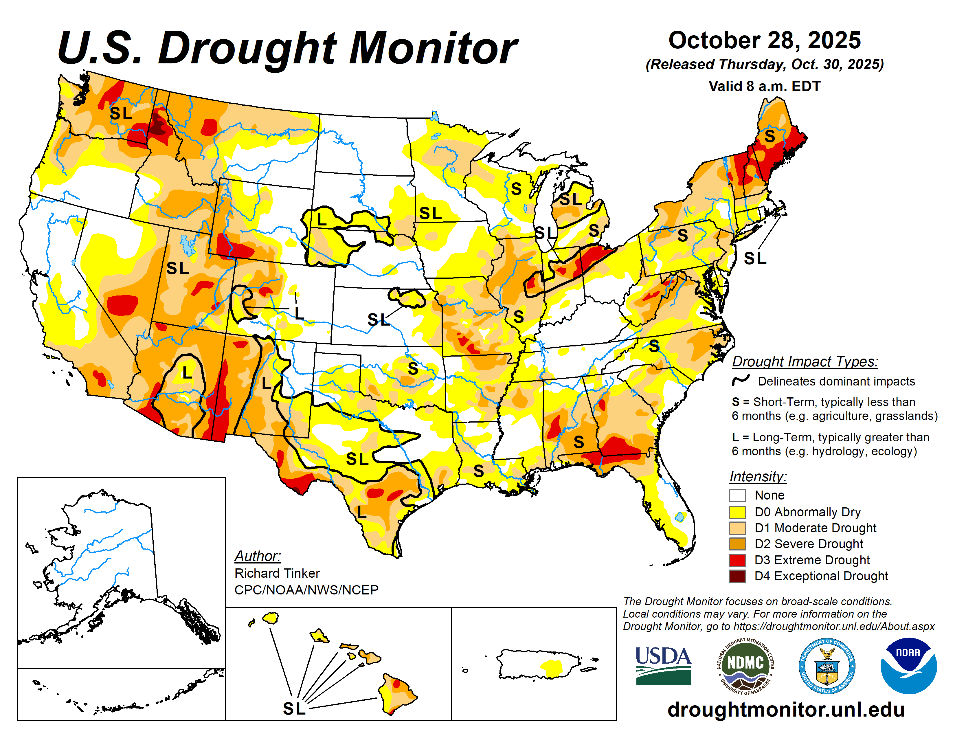
This Week’s Drought Summary
Heavy precipitation (over 3 inches) was observed last week over many of the higher elevations and coastal areas from northern California to the Canadian Border. Farther east, similar amounts doused numerous locations from Oklahoma southward to central Texas, a few areas across the lower Mississippi Valley, portions of the southern Appalachians, parts of the central Gulf Coast, the east-central Florida Peninsula, and some areas just downwind of Lake Erie. Between 5 and 10 inches of precipitation fell on a few areas in the coastal and higher elevations of Washington and Oregon, north-central through east-central Oklahoma, northeastern Texas, south-central Mississippi, and east-central Florida. Moderate to heavy precipitation (between 1 and 3 inches with isolated higher amounts) was reported across the rest of the Pacific Northwest, parts of the higher elevations in the northern Intermountain West, part of the northern Great Plains, most of central and western Michigan, a few patches across New England, and many areas from the central Carolinas to the central Great Plains, plus much of northern and central Texas, the southern Lower Mississippi Valley, and a few patches across northwestern and central Florida. Other locations across the Conterminous U.S. (“Lower-48”) received only a few tenths of an inch at best.
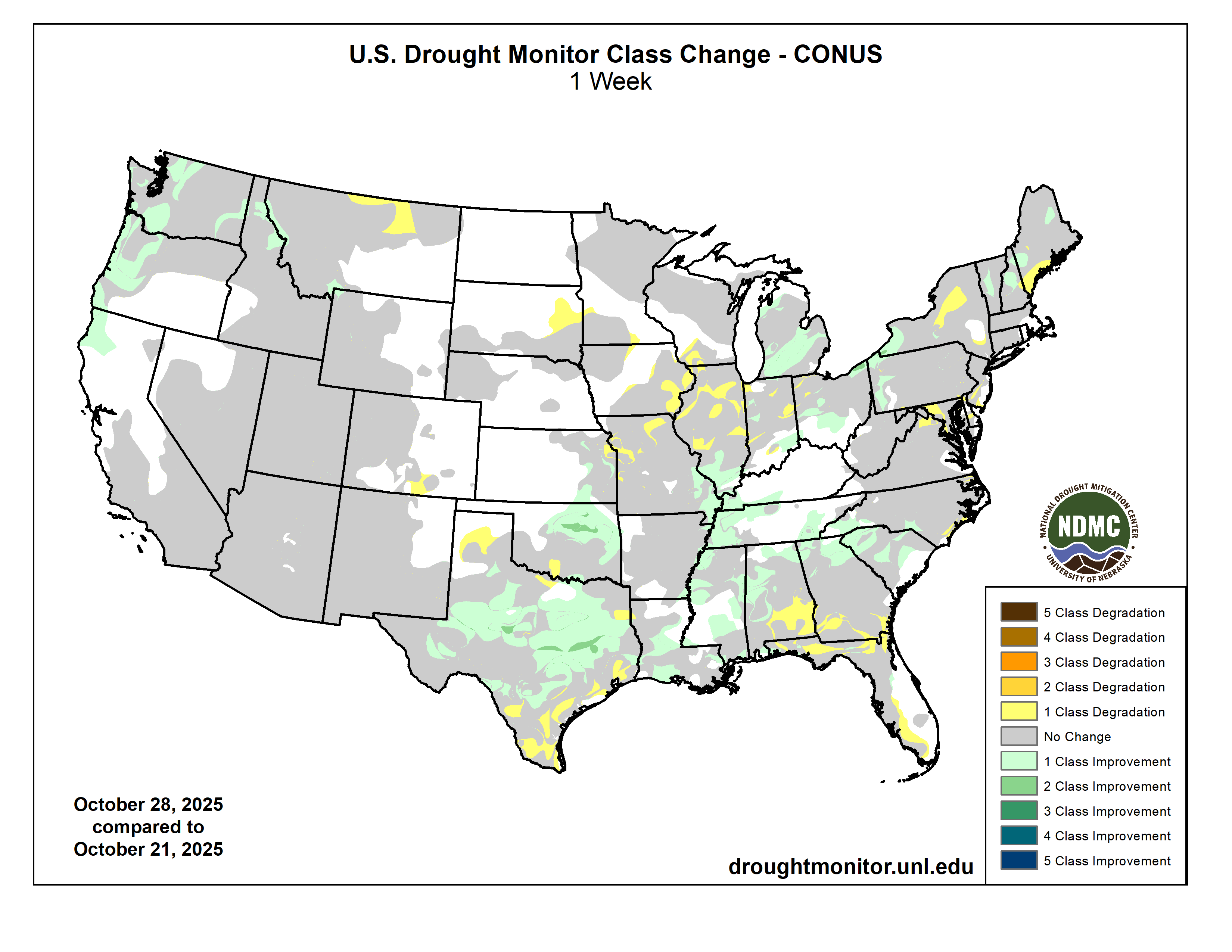
This resulted in significant areas of improvement in the Pacific Northwest, northern Intermountain West, the Great Plains from eastern Kansas through central Texas, the interior Deep South, the Ohio Valley, the eastern Great Lakes, the Carolinas, the southern Appalachians, and a few patches in New England. In some of the drier areas, dryness and drought conditions deteriorated in a few parts of the central and northern High Plains, the Texas Panhandle, Deep South and Coastal Texas, southern Alabama and Georgia, and small areas in the mid-Atlantic, and the Northeast from New York to coastal Maine. Deteriorating conditions also affected small parts of Hawaii (Upcountry Maui, northeastern Maui, and the southeastern Big Island). Conditions in Puerto Rico were unchanged with abnormal dryness persisting in parts of southeastern Puerto Rico, and Alaska remained free of any dryness or drought.
Overall, coverage of D0 or drier conditions across the Lower-48 declined slightly from 72 to 69 percent, remaining well above the average coverage since 2000 (49.2 percent). Drought (D1 or worse) extent also declined slightly from 46.1 to 43.6 percent of the Lower-48, also above the average since 2000 (31.1 percent)…
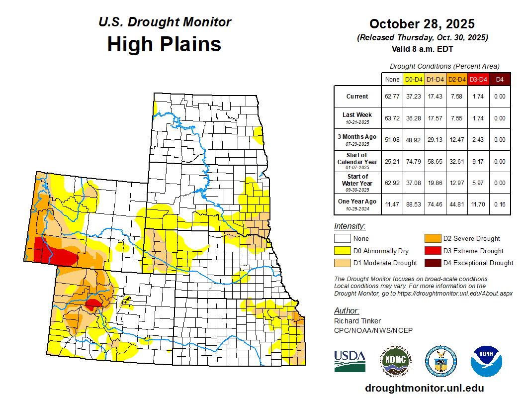
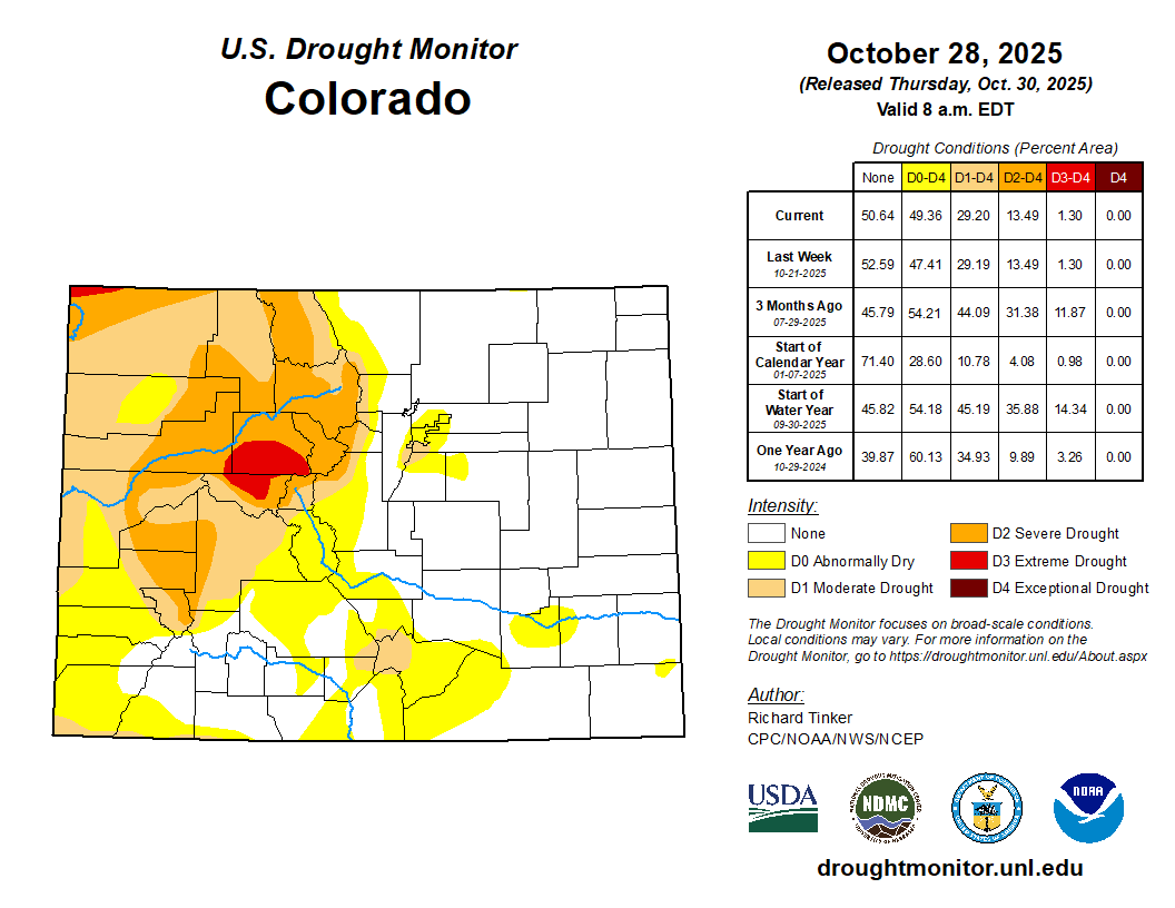
High Plains
The High Plains Region is currently the Region least-affected by dryness and drought. Only 37.2 percent of the Region is affected by dryness (D0) or drought (D1-D4). Colorado and Wyoming are the most drought-impacted states, with almost 55% of those states combined covered by D0 conditions or worse, and about one-third experiencing some degree of drought (D1-D4), primarily in the higher elevations. In the Great Plains states, there is no drought in North Dakota and D0 covers less than 3 percent of the state. Dry conditions are a little more common farther south, with D0 or worse covering 39 percent of South Dakota, 35 percent of Nebraska, and 25 percent of Kansas. In all 3 states, drought (D1 or worse) coverage is less than 13 percent. Last week, moderate to locally heavy rain induced areas of improvement in eastern Kansas and far northwestern Wyoming while patches of deterioration were introduced in eastern South Dakota and small parts of south-central Colorado and far northeastern Kansas…

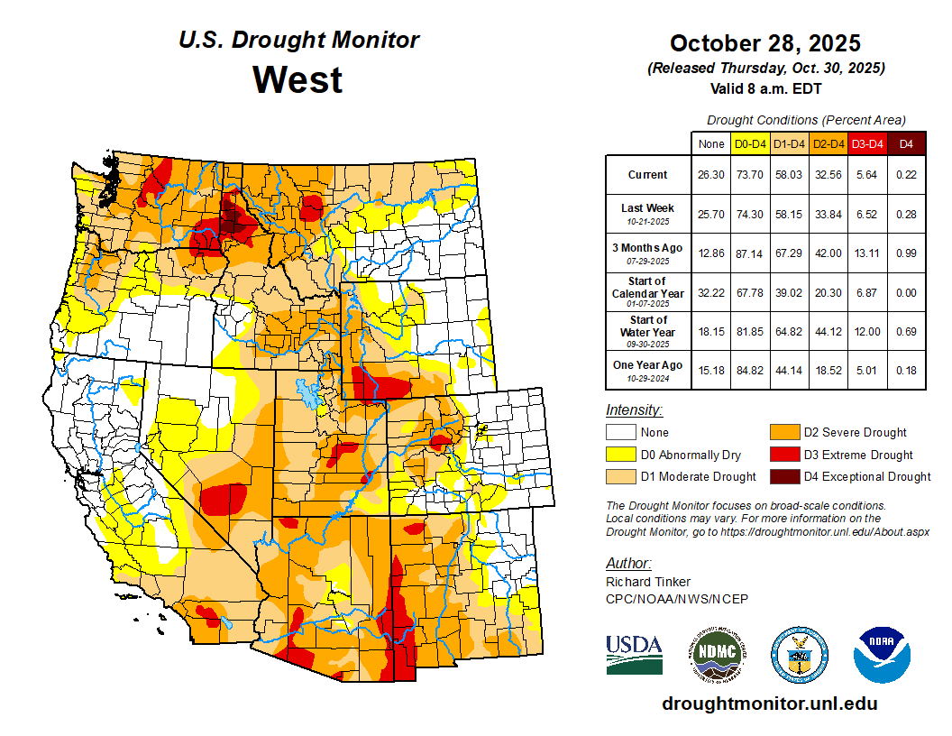
West
Following substantial changes across the West Region last week, conditions generally persisted across all but the northern tier of the West Region, with no changes made relative to last week across New Mexico, Arizona, Utah, Nevada, and most of California. Across the northern tier of the West Region, heavy precipitation engendered improvement in a few areas, mostly across northern California, Oregon, and Washington from the Cascades to the Pacific Coast. Many locations in the higher elevations of Washington and near the Washington and northern Oregon coastline measured over 3 inches of precipitation, with scattered amounts of 4 to locally over 8 inches recorded, particularly in northwestern and north-central Washington. Farther east, recent precipitation led to some improvement across western Montana and northern Idaho while, to the east, recent deficient precipitation totals led to deterioration across north-central Montana…
South
Heavy rains in many regions engendered broad areas of improvement across most of Texas, Oklahoma, Louisiana, Mississippi, and Tennessee. Some areas of deterioration were observed in areas that missed the heavy rains, specifically southern and coastal Texas, part of the Texas Panhandle, and a few patches of the Red River (South) Valley. Several inches of rain resulted in a few swaths of 2-category improvement across central and east-central Texas as well as central Oklahoma, where upwards of 4 to 8 inches of precipitation were observed. Overall, coverage of dryness and drought dropped from 80.6 to 68.6 percent of the Region while drought coverage (D1 or worse) was reduced from 37.1 to 27.6 percent. D3-D4 extent inched down slightly from 10.7 to 9.6 percent. But despite the wet week, 90-day rainfall amounts ranged from 3 to 6 inches below normal across much of the Red River (South) Valley, and from 4 to locally over 10 inches from central Texas eastward along and near the Gulf Coast…
Looking Ahead
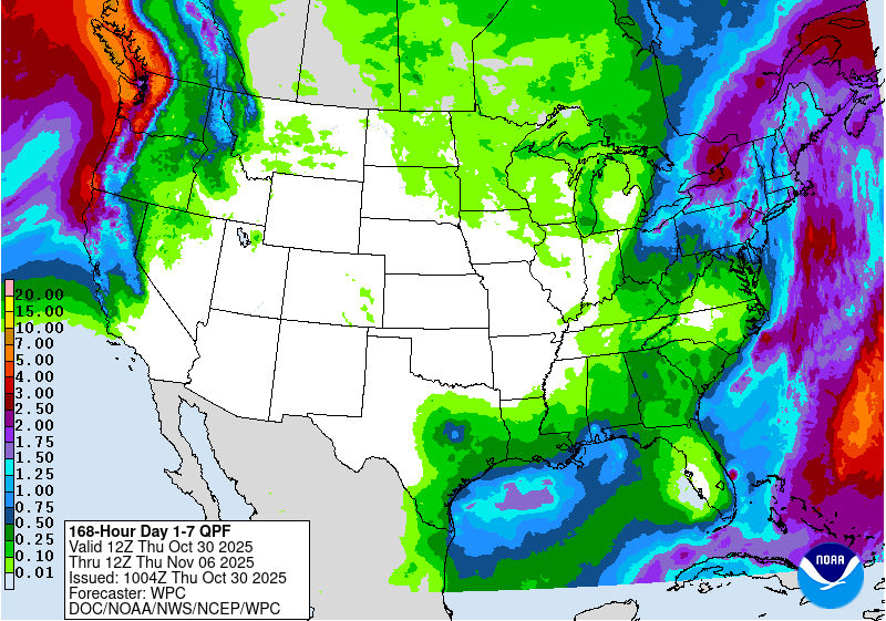
Over the next 5 days (October 30 – November 3), a large part of the Lower-48 is expecting little or no precipitation, specifically most areas from the Appalachians to the Pacific Coast. Light to moderate amounts are forecast for most of interior New England, the central and southern Appalachians, the Oregon Cascades and Coast, the higher elevations of the Intermountain West, much of Peninsular Florida, and portions of the South Atlantic Coastal Plain. Heavier amounts exceeding 1.5 inches are anticipated across the Washington Cascades and Coast, isolated spots near the central and western Gulf Coast, much of the middle and upper Ohio Valley, most of a broad swath from Maryland through New York, and the Florida Keys. Daily high temperatures are forecast to average 2 to 4 deg. F below normal across the Southeast, and near normal over the Northeast and the Lower Mississippi Valley. Unusual warmth featuring daily Highs 4 deg. F or more above normal is expected across the northern Great Plains and most locations from the High Plains to the Pacific Coast, outside the Pacific Northwest. Average daily highs could reach 10 to 14 deg. F above-normal across the eastern Great Basin and the central and northern Rockies.
During November 4 – 8, wetter than normal weather is again expected in the Pacific Northwest, expanding to cover the northern Intermountain West, western Great Basin, and central through northern California. Odds for wetness exceed 50 percent from northwestern California through central and western parts of Washington and Oregon. Elsewhere, wet weather is marginally favored in much of the South Atlantic, south-central and southeastern Alaska, and portions of northern Alaska. Meanwhile, most of a large swath from the Rockies to the Appalachians have enhanced odds for drier-than-normal conditions, with chances topping 50 percent across New Mexico and the western half of Texas. Subnormal precipitation is also marginally favored across all but the eastern fringe of the Big Island in Hawaii. Warmer than normal conditions are favored from the Great Lakes and lower Ohio Valley through most areas from the Mississippi Valley to the Pacific Coast. Enhanced chances for warmer-than-normal weather also cover southern Florida, south-central and eastern Alaska, and Hawaii. Most areas over and near the central Rockies have chances for warmth exceeding 80 percent. Subnormal temperatures are only favored in New England and adjacent New York. In other areas, near normal temperatures are most likely.