
Click the link to read the article on the WyoFile website (Dustin Bleizeffer):
December 30, 2025
It was a balmy, gusty Christmas for much of Wyoming, where only high elevations in the western portion of the state saw fresh snow. It rained in Jackson Hole while lower elevations in central Wyoming saw temperatures in the 60s with 60-plus mile-per-hour winds, according to reports.
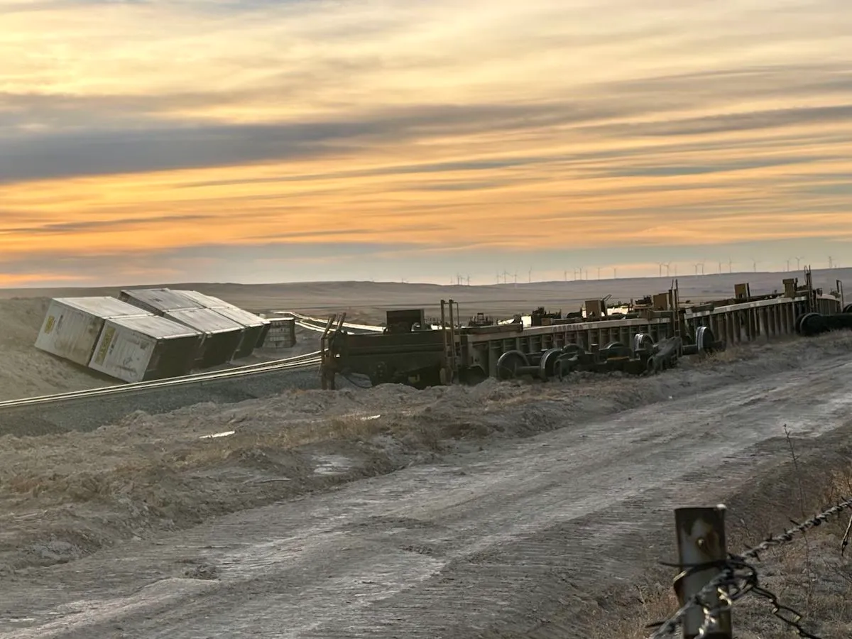
The holiday was a continuation of a theme in which weird and wild weather defined much of December as high-pressure systems lingered over the region for the better part of three weeks, the National Weather Service in Riverton said. Residents and travelers alike battled sustained high winds from border to border, and a Dec. 19 blast measured 144 miles per hour — Category 4 hurricane speed — at Mount Coffin in western Wyoming. Another wind blast the same day tossed a train off the tracks near Cheyenne, BNSF Railway confirmed.
Wyoming Highway Patrol responded to 39 blow-over accidents in just three days in December, according to state officials.
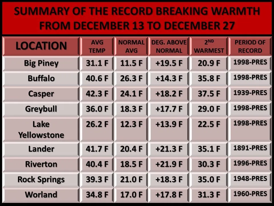
As the wind wreaked havoc, nine Wyoming locations saw unseasonably high temperatures averaging 13 to 22 degrees Fahrenheit above normal from Dec. 13 through Dec. 27, according to the National Weather Service. Both Lander and Casper are on track to notch their warmest Decembers since 1892 and 1948, respectively, NWS Riverton meteorologist Adam Dziewaltowski said. Casper, as of Monday, had marked 10 record-breaking daily highs, while Lander saw a record high of 65 degrees on Christmas Eve.
Yet for all the bluster and heat, meteorologists caution against reading too much into what it might portend for the remainder of winter. Cold and snow returned over the weekend, and the state frequently receives most of its snow in early spring, sources say.
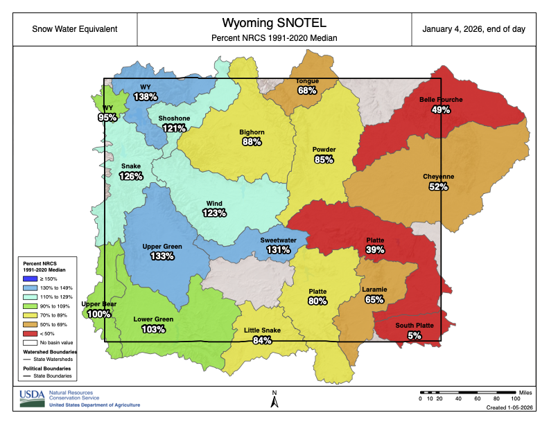
Currently, Wyoming’s “snow-water equivalent” is above average for most of western Wyoming, while areas on the east side of the state lag behind late December norms. Central-east and southeast Wyoming are the driest, with the southeast measuring just 5% of its typical snow-water equivalent, according to a U.S. Department of Agriculture report on Monday.

But even in some areas of the state, like Jackson, where precipitation is above average, a portion of the wet stuff has come in the form of rain instead of snow.
“Right now, [Jackson is] almost two inches above normal for precipitation — liquid-wise,” Dziewaltowski said. “They’ve definitely gotten precipitation, but it’s been so warm that it hasn’t fallen as snow.”
Some high elevations have seen rain-on-snow events, which can create adverse conditions for slides, Dziewaltowski added.
Though the weather took a turn after Christmas, swinging from the balmy 60s to below zero in just 48 hours in some areas, the forecast calls for more unseasonably warm temperatures later this week, according to the Weather Service.
December’s wild and warm conditions made for odd outdoor experiences.
Laramie angler Eric Wiltse posted his December fishing outings to Facebook and confirmed with WyoFile several “alarming” seasonal observations. Early this month, he waded into Twin Buttes Lake, which had been frozen just days before. He saw rain at 7,200 feet of elevation, and while fishing in Curt Gowdy State Park on Christmas Eve, he shared the open water with other outdoor enthusiasts who typically don’t appear in the winter.
“Crazy to be fly fishing on Christmas Eve at 7,500 feet in Wyoming,” Wiltse posted. “Even crazier to see a paddleboard on the lake.”