The graphs below show missing data over the weekend.


The graphs below show missing data over the weekend.

Click the link to read the article on the Alamosa Citizen website:
February 28, 2026
Rancher Greg Higel usually opens a barn door for his cows to enter during the cold winter nights. Lately he’s been leaving the cows out at night because “the less you mess with them, the better off they are.”
The February weather has been warm enough not to mess with the cows.
The last two Februarys – 2025 and 2026 – have seen the daily maximum temperature average 50 degrees-plus in Alamosa, according to National Weather Service data. That has never happened before in the Valley’s climate history.
National Weather Service records as far back as 1948 show only the past two Februarys so warm that ranchers like Higel, who are in the midst of their calving season, worry less about their cows at night and more about their grassfields and what the warm winter means for the ground itself. Included in that are overnight temps averaging in the double digits and frequently in the 20s.
“I don’t think it’s good for the farm ground,” Higel says. He was hopeful the heavy October rains that had flooded his meadows would leave water frozen in the fields through the winter months. But the water hardly froze and the worry now is the anticipated light spring runoff and available water for the grass growing season ahead.
Of the 28 days in February this year, 20 have seen the daily maximum temperature exceed 50 degrees. The highest temperature for the month was 65 degrees on Feb. 25, following 64 degrees on Feb. 24, which established a new high for the date.
February 2025 was just as warm and warmer, with an average daily high temperature of 52.8 degrees. It was a year ago when the phenomenon of average 50-degree weather days was first noted after the mercury hit 60 degrees on 5 of the first 7 days of last February.
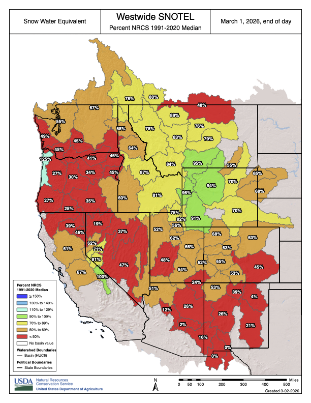
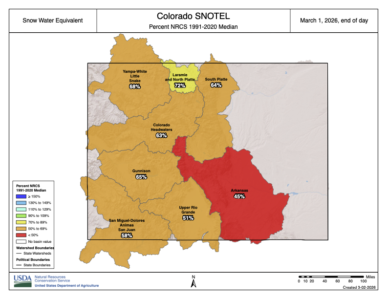
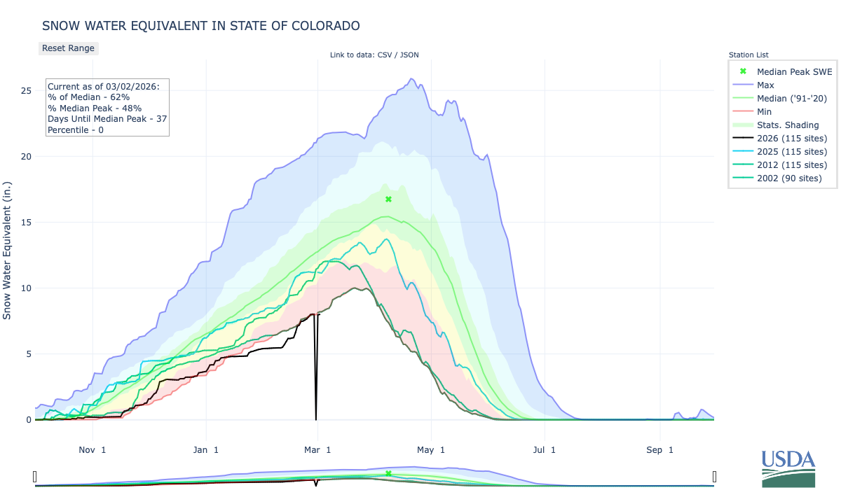
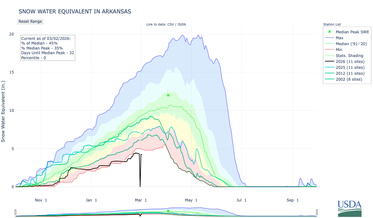
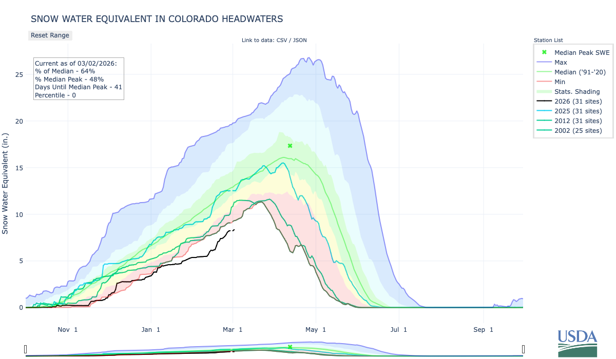
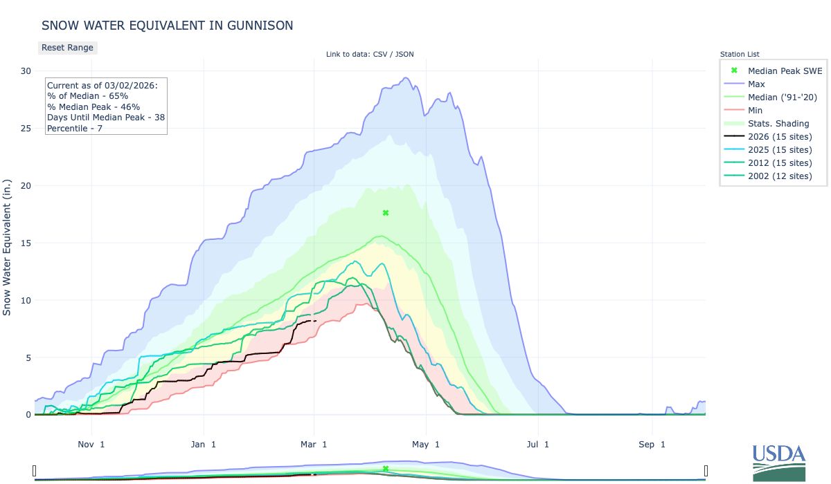
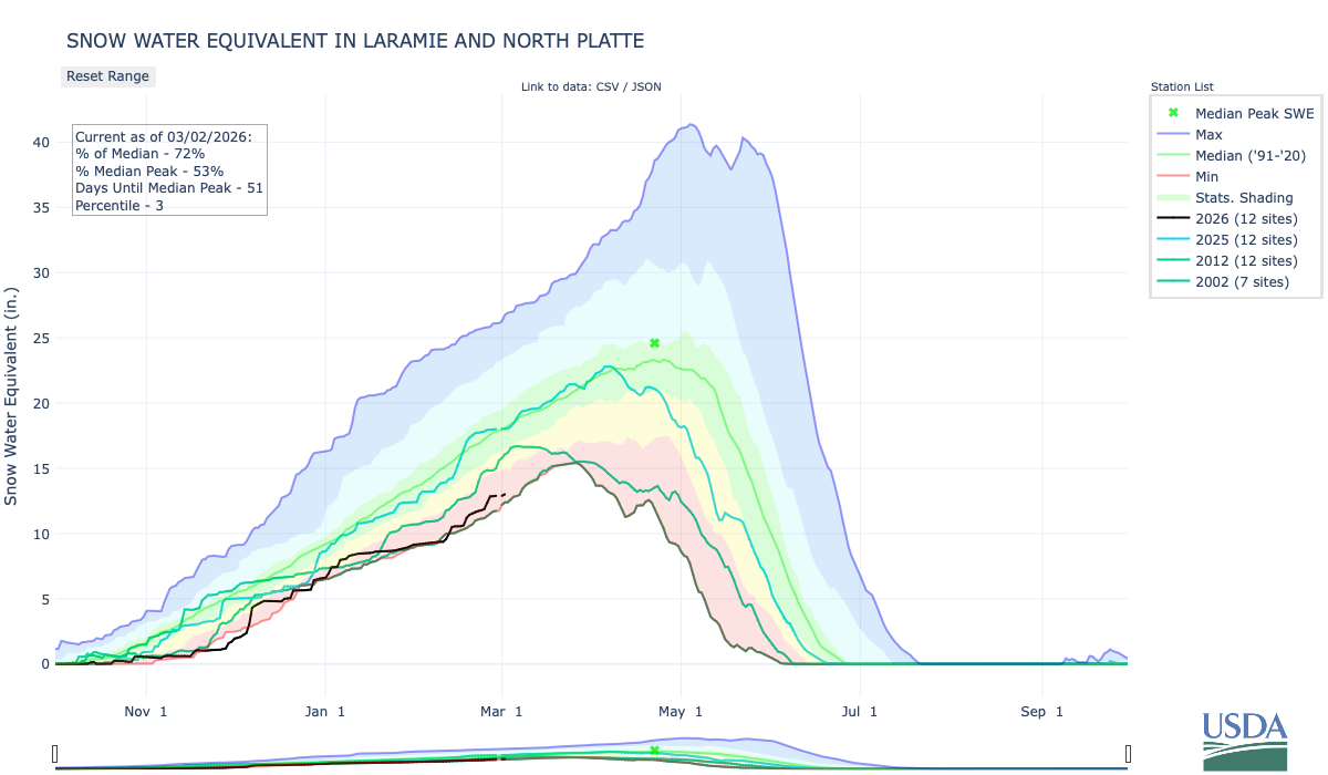
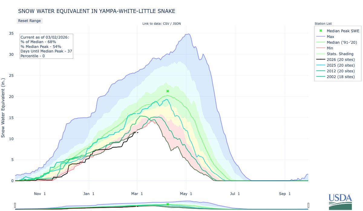
Suffice it to say, if it is this warm in February in the high mountain desert, the snowpack is going to suffer. The Upper Rio Grande Basin enters March measuring 55 percent of median on a snowwater equivalent index, which is what worries irrigators.
And it’s not just ranchers and farmers who should be paying attention.
Adam Moore, supervisory forester with Colorado State Forest Service, says trees around the home need watering when the winter months are this warm. The constant threat of wildfire is another reason to pay attention.
“The SLV and the plains are still facing red flag warnings. There have been large grass fires in Oklahoma and Kansas. The conditions for those fires are not much different than what we have in the SLV. Just like the red flag warnings all year long, wildfire preparedness should occur all year,” he says.
Just don’t get too far ahead. Gardeners should stick to the normal planting times, with mid-April being the earliest for any tree planting.
“Don’t let the warm weather fool you and plant early,” Moore says. “We still stand the chance of late frosts.”
Tell that to Tomas Miera.
“I’ve been riding all winter. My goodness, today is going to be like 64,” he says, standing in his front yard in a short sleeve shirt, shorts and shining his Harley Davidson. “I’m going for a ride later on.”
February allows for it. It’s never been this way.
Click the link to read the article on The Land Desk website (Jonathan P. Thompson):
February 27, 2026

🥵 Aridification Watch 🐫
Back in the late 1990s and early 2000s, when I lived in Silverton, Colorado, elevation 9,318 feet, we often experienced a “January thaw.” It was a period of a few sunny, warm days between storms that usually fell in January but could also occur in February. If you could find a south-facing deck that was protected from the wind and free of dangling, skull-piercing icicles, you could sit out in shirtsleeves, soak up some vitamin D, and maybe even get a little bit of a suntan. Then winter, below zero temperatures, and super snowy San Juaners would return, finally and grudgingly departing sometime in late May.
A pretty big swath of the Southwest is about to experience a February thaw of its own, according to National Weather Service forecasts, including in these hot spots:
- Phoenix’s mercury could climb into the low- to mid-90s this weekend [February 28 – March 1, 2026], with overnight lows in the 60s.
- Durango, Colorado, is expecting to hit 66° F on Sunday (with lows staying above freezing).
- It will be prime bike-riding weather in Moab, where the highs could climb into the low 70s.
- And even Silverton will get up into the 50s, with the overnight lows dipping only a few degrees below freezing — bad news for the snow.
- Denver is under a red flag warning for fire danger today, and will see temperatures in the high 60s.
During a “normal” winter, this wouldn’t be alarming in the slightest. In fact, it would be a welcome respite from winter. Now it threatens to wipe out any indication that it even is winter by potentially erasing the snowpack gained during last week’s storms. The Upper Colorado River Basin’s snowpack is exactly at the same level as it was on this date in 2002. Ohhh boy, if those March storms don’t arrive it’s going to be a long, dry summer.
The trouble with normal … — Jonathan P. Thompson
💧 Colorado River Chronicles 🐟
As a deal between the seven Colorado states for how to divvy up massive consumption cuts seems less and less likely, Arizona is getting a bit more aggressive.This week the Protecting Arizona’s Lifeline Coalition launched a PR campaign, complete with videos, attempting to pressure the Upper Basin states to let more water flow downstream to its Lower Basin neighbors.
Arizona is understandably worried: The Central Arizona Project’s water rights are junior to most of the other large users in the Lower Basin, meaning they would be among the first to take cuts if there were a shortage. The window for a dramatic improvement in Upper Basin snowpack is rapidly closing, thereby increasing the likelihood of a shortage later this year.
The campaign includes a series of videos with various officials making their case. There are also a few educational ones that do a nice job of explaining the Colorado River Compact, and are really worth a watch. However, I should warn you that they are coming from a Lower Basin perspective, meaning they interpret one clause of the Compact, Article III(d), significantly differently than the Upper Basin states. And yet, that’s what their entire argument relies on.
That clause states that the Upper Basin must “not cause the flow of the river at Lee Ferry to be depleted below an aggregate of 75 million acre-feet” for any 10-year period.
The Upper Basin sees this as a “non-depletion obligation,” meaning it blocks them from exceeding their 7.5 MAF/year allocation if it causes the Lee Ferry flow to fall below a 7.5 MAF/year average. The Lower Basin sees it as a “minimum delivery obligation,” meaning that the Upper Basin is obliged to send an average of 7.5 MAF past Lee Ferry no matter what, even if that means draining all of its reservoirs and drying out its fields and cities.
Keeping that in mind, check out the video:
A Colorado River glossary and primer — Jonathan P. Thompson
The Colorado River Crisis is Here — Jonathan P. Thompson
🤯 Oh, the Humans! 😱
In a comment on Tuesday’s dispatch, reader Steve Harris suggested a story on the U.S. Customs and Border Protection fast-tracking a 200-mile segment of border wall through Big Bend National Park.
This is a super important issue. And it’s not only in Big Bend: The entire border wall is an environmental disaster, slashing through biologically diverse, beautiful country and cutting off migratory routes and movement for mountain lions, javelina, coyotes, ocelot, deer, desert bighorns, and even jaguars. Keep in mind that it’s not just a fence, it’s a giant piece of infrastructure that requires bulldozing all the vegetation and even blasting through the landscape. Besides that, we taxpayers are forking out billions of dollars for something that isn’t all that great at doing what it’s supposed to do.
For me it’s especially heartbreaking to see the wall cut through the borderlands south of Tucson, down in the Patagonia Mountains. Many years ago my dad took my brother and I along some little road through there right up against the border, which at the time was just a barbed wire fence. It was incredible country, so quiet and mostly humanity-free.
The stakes are equally as high in the Big Bend area, where both ecological and cultural treasures are at risk. Unfortunately I’ve never been to Big Bend, and it’s a little ways outside the region I normally cover, so I’m not going to try to pretend to know what’s going on there. But a lot of other smart folks have written about it and are trying to block the new stretch of wall, so I’ll share some of that here:
- Border Patrol map of existing, planned, and awarded segments of wall, including the stretch through Big Bend — which consists of about 100 miles of actual physical wall plus segments of “detection technology” in the most rugged areas.
- The Border Wall Map with videos showing what’s at stake.
- The Texas Observer has a good story on the wall plans and the way the “Big Beautiful Bill” not only allocates $46.5 billion to build the monstrosity, but also erased existing protections for some areas.
- The Texas Tribune and Inside Climate News worked together on a story that talks about local opposition.
- Peer-reviewed study on how the border wall impedes wildlife movement.
🌵 Public Lands 🌲
Environmental groups and environmentally-oriented media outlets are making a pretty big stink over the confirmation hearings for Steve Pearce, Trump’s pick to lead the Bureau of Land Management. There’s a good reason for this: Pearce is well known for his hostility toward the BLM and the public lands it oversees, and he has also indicated a desire to sell off public land — a stance he failed to renounce during this week’s hearings.
Pearce is a bad choice for this job. But is it worth spending a lot of resources to get him ousted? Probably not.
If the Senate does not confirm Pearce, then the administration will just find some other bozo to do the job, which in this case is basically a middle manager tasked with carrying out the agenda of Interior Secretary Doug Burgum. Burgum, in turn, is merely executing the Trump administration’s, i.e. Project 2025, policies.
Which I have to say is disappointing and sad. Before he was a cabinet member, Burgum seemed like a reasonable enough guy. Sure he has ties to oil and gas interests, but he also appeared to be a Teddy Roosevelt Republican — an old school conservative and conservationist who valued public lands. He even managed to garner the endorsement of outdoor retailer REI’s board along with that of the hook and bullet crowd.
Instead, he has prostrated himself to the extractive industries, embraced coal mining and oil and gas drilling, and shattered environmental protections for public lands left and right. His distinguishing features as a cabinet member have been his unwavering sneer-like grin and his tendency to fawn over Trump — and coal.
***
Your energy and outrage might be better spent on convincing Congress to shoot down Sen. Mike Lee’s, R-Utah, attempt to use the Congressional Review Act to revoke the Grand Staircase-Escalante National Monument management plan. If the “resolution of disapproval” passes both chambers of Congress with a simple majority vote, it would erase the plan and bar the Bureau of Land Management from issuing another plan that is “substantially the same” in the future.
Republicans in the current Congress used the CRA — which allows Congress to revoke recently implemented administrative rules — to do away with resource management plans in Alaska, Montana, and North Dakota. That’s in spite of the fact that RMPs are not considered “rules,” according to a January 2025 opinion by the Interior Department’s Solicitor. National monument management plans aren’t rules, either, but that’s not a hindrance for Lee.
This wouldn’t change the boundaries of the monument, but would likely cause management of the area to revert back to the 2020, Trump I-era plan. That plan was not only less protective than the newer one, but only applied to a much smaller area, since in 2017 Trump had significantly shrunk the national monument. Revoking the current management plan, then, would leave vast areas of the monument in a sort of management limbo.
It would also open the door to revoking other national monument management plans (e.g. Bears Ears), allowing the GOP to carry out Project 2025’s goal of shrinking or eliminating national monuments in a less visible, more underhanded manner.
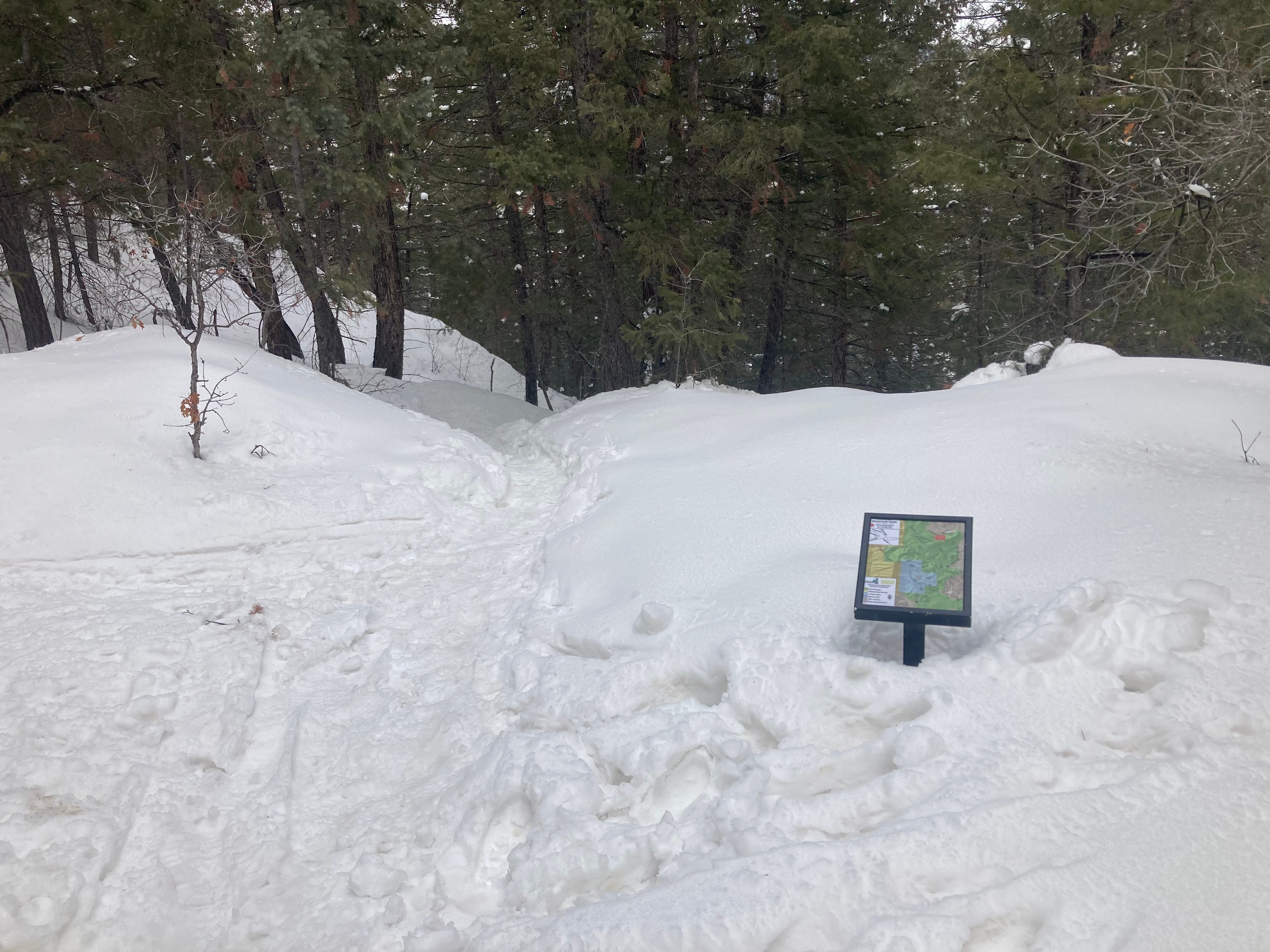

Just a couple reminders from a few years ago that it does snow, and it will snow again — just maybe not this spring. Jonathan P. Thompson photos.