

Click the link to read the article on The Land Desk website (Jonathan P. Thompson):
March 24, 2026
⛏️ Mining Monitor ⛏️
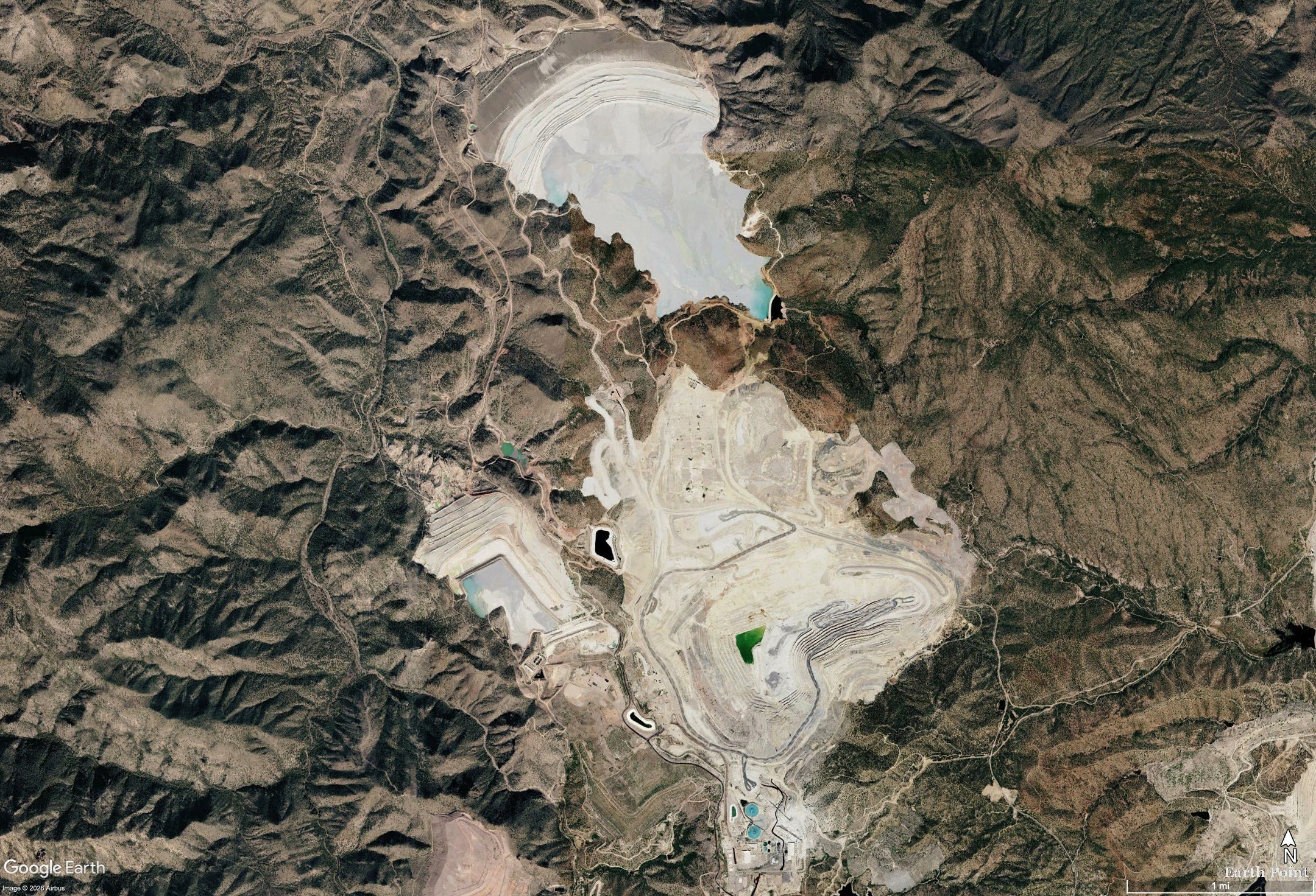
Pinto Creek used to run year-round. Bubbling up from springs and occasional snowmelt in the Pinal Mountains of central Arizona, it nourished a riparian ribbon of green through the rocky, arid landscape, shaded by sycamores, willows, and alders, until it empties into Theodore Roosevelt Reservoir. Gila topminnow, longfin dace, and roundtail chub plied its waters. Even during drought years it reliably delivered at least 1,000 acre-feet of water at its Magma Weir gauge, and in wet times as much as 39,000 acre-feet annually might flow along its bed.
Then, a little over a decade ago, something odd happened. The flow volume plummeted from 4,147 acre-feet in 2013 to just 482 acre-feet in 2014, and ever since the once year-round stream has run only intermittently and at similarly diminished levels. Towering trees along its banks have died and toppled, and the green swath has lost much of its color. It’s possible that long-term aridification simply caught up with the little stream, as 2013 was a dry year. But there’s a more likely culprit: In October 2013 Capstone Copper Corporation acquired the nearby Pinto Valley Mine, a massive, open pit copper and molybdenum operation that had just emerged from several years of dormancy, and resumed heavy groundwater pumping from its Peak Well field.
While correlation is not causation, the Tonto National Forest saw enough evidence of a link to ask the Arizona Department of Water Resources to put the brakes on the mine’s groundwater pumping. Failing to do so would harm the Forest Service’s instream Pinto Creek water right — along with the downstream riparian ecosystem it supports. The state did nothing and the Forest Service dropped the complaint and approved the mine’s expansion in 2021.
The Land Desk has often looked at mining’s effects on water quality.1 But the Pinto Valley case highlights the fact that mines can also affect water quantity — and vice versa, as water scarcity can limit mining operations. It warrants a closer look during these water-constrained times, when water consumption by everything from data centers to golf courses to alfalfa farms has attracted more scrutiny.
A mining operation goes through water in two ways. First, the mine itself, whether underground or open pit, can act like a well. Dig a hole into the earth, and groundwater will flow into it. While gravity can drain this flow in underground mines burrowed into the sides of mountains, the water must be pumped from open pit and underground shaft mines, a practice known as dewatering, which can take large amounts of water out of the aquifer. Capstone says it pumps about 400 gallons per minute from its pit.

This draws down groundwater wells and can dry up springs and diminish streamflows. Without dewatering, you end up with something like the Berkeley Pit, which is now a 50-billion-gallon, acidic and contaminated lake that’s about 900 feet deep. Because this water is usually contaminated by acid mine drainage, it often can’t be reused without some treatment, and dumping it into a stream or back into the aquifer is also problematic.
A mining operation also requires significant amounts of water for dust control, mineral processing, slurrying, and other uses. Capstone’s 2024 sustainability report says its Pinto Valley Mine withdrew a total of 8,932 acre-feet — or 2.9 billion gallons — of groundwater and surface water.
The company has not released its 2025 data yet, but in financial filings reported that the Pinto Valley Mine had to slash mine production and mill throughput by about 37% in 2025 due to “unplanned downtime driven by water constraints due to the drought conditions in central Arizona.” The company is trying to address this by reducing per-ton water usage by 20%, but that may not be enough given the extreme drought conditions spreading across the Southwest.
A central clearing house or database of mine water use in Arizona does not exist, but various sources can help paint a picture of how much water the mining industry in the state uses (I’ll look at other states in a future dispatch).
- Safford Mine Complex: Consumptive water use increased from 3,624 acre-feet per year to 6,099 af/yr following a 2020 expansion, according to the Arizona Department of Water Resources 2025 Safford supply and demand report. Municipal uses in the Safford Basin use about 6,000 acre-feet per year, while agriculture — primarily for cotton, pecans, pistachios, and alfalfa — consumes about 138,301 acre-feet annually.
- Freeport-McMoran reported to the AZDWR that in 2023 it withdrew 22,490 acre-feet of groundwater for its Sierrita Mine south of Tucson. The cost? $3.50 per acre-foot. That’s about one penny for 1,000 gallons of water.
- Freeport-McMoran’s Morenci Mine, one of the nation’s largest copper operations, uses about 14,000 acre-feet per year on average, according to the AZDWR. The mine imports much of its water from the Black River, a tributary to the Salt River, under a lease with the San Carlos Apache Tribe for a portion of its Central Arizona Project allocation.
- The following chart is from an Arizona Department of Mines & Mineral Resources report from 2010 by Dr. Madan M. Singh. It’s a nice, comprehensive look at how much water the state’s major mines used in the preceding years. Current use is likely about the same, except that now there are additional mines (the Pinto Valley Mine was not operational in 2010, which is why it’s missing).
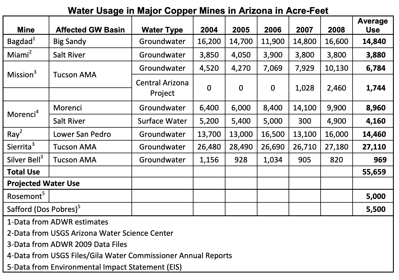
So, according to Singh’s report, Arizona’s largest mines used a total of 55,659 acre-feet per year during the 2000s. Add the Pinto Valley Mine (8,932 af) and Safford Mine (6,099 af) and you get about 70,600 acre-feet per year, or 23 billion gallons annually.
That’s a lot of water, but it pales in comparison to many other uses. Arizona alfalfa, alone, probably uses more than 1.5 million acre-feet (based on 6 af water/acre over 280,000 planted acres, according to the USDA). “Turf facilities” guzzled some 157,000 af in 2024, according to the AZDWR, while power generation used 86,053 acre-feet. TSMC’s north Phoenix chip manufacturing facility is projected initially to use about 19,000 acre-feet of water annually.
In other words, when Arizona’s water cops come looking for the big water users, the mines probably won’t be at the top of their list. Since most mines rely on groundwater, Colorado River water shortages may not affect them too much, at least in the near future.
Still, some mines, including ASARCO’s Mission Mine, do pull some water from the Central Arizona Project, which could be hit hard by the Colorado River crisis as early as next year. And, as the Pinto Valley Mine situation last year demonstrated, continued aridification and relentless pumping could lead to groundwater shortages at the mines, forcing them to reduce production even as they work to become more water-efficient.
Prospective mines could face serious challenges, as well. Resolution Copper estimates its contentious Oak Flat mine would use between 15,700 acre-feet and 20,000 acre-feet per year. Others, however, say this is too low; one study says it would likely be closer to 50,000 acre-feet annually, based on the per-ton water consumption for copper at other Arizona mines. Resolution has said it would rely at least partly on Central Arizona Project water, the security of which grows shakier with each passing year. It’s hard to imagine that there will be any water available for new users by the time that mine is up and running if current climatic trends continue.
That may be what Faraday Copper had in mind when it signed a letter of intent to acquire the San Manuel copper mine in southern Arizona. While Faraday said it would be reopening the long-shuttered operation and combining it with its proposed Copper Creek venture nearby, it may also be eying the substantial water rights BHP Copper holds for the San Manuel Mine. Those could come in handy if and when the Copper Creek facility is developed.
Regardless, however, one thing is clear: Any new mine is going to rob the springs, the streams, and the wildlife and communities that rely on them of at least some of their precious water. [ed. emphasis mine]
1 In 1993, when the Pinto Valley Mine was operated by Magma Copper, a large rain event “overwhelmed the mine’s water management capabilities,” causing the reservoir to overflow the tailings pile, tear out a levee, and carry hundreds of tons of tailings and millions of gallons of contaminated water into Pinto Creek. The creek was found to have low pH (high acidity) and high concentrations of cadmium, copper, lead, mercury, and zinc, resulting in significant fish die off, specifically of desert or Gila Mountain suckers.

Click the link to read the article on the Pagosa Springs Sun website (Clayton Chaney). Here’s an excerpt:
March 26, 2026
It was warmer last week in Pagosa Country than any other time on record, as the area saw five consecutive days of record high temperatures set from March 18-22. According to forecasts posted by Shawn Prochazka with Pagosa Weather, a new record high for the month of March was set on Wednesday, March 18, at 74 degrees and again on Thursday, March 19, at 76 degrees. The previous record high for the month of March was set in 1907 and 1940 at 73 degrees. Record highs for the month continued on Friday, March 20, with temperatures reaching 79 degrees. The previous record for that date was 68 degrees, set in 1997. Prochazka also notes that record high temperatures were set on Saturday, March 21, at 77 degrees, and on Sunday, March 22, at 74 degrees…
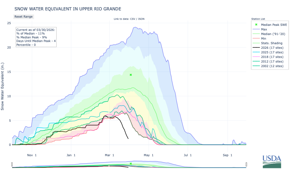
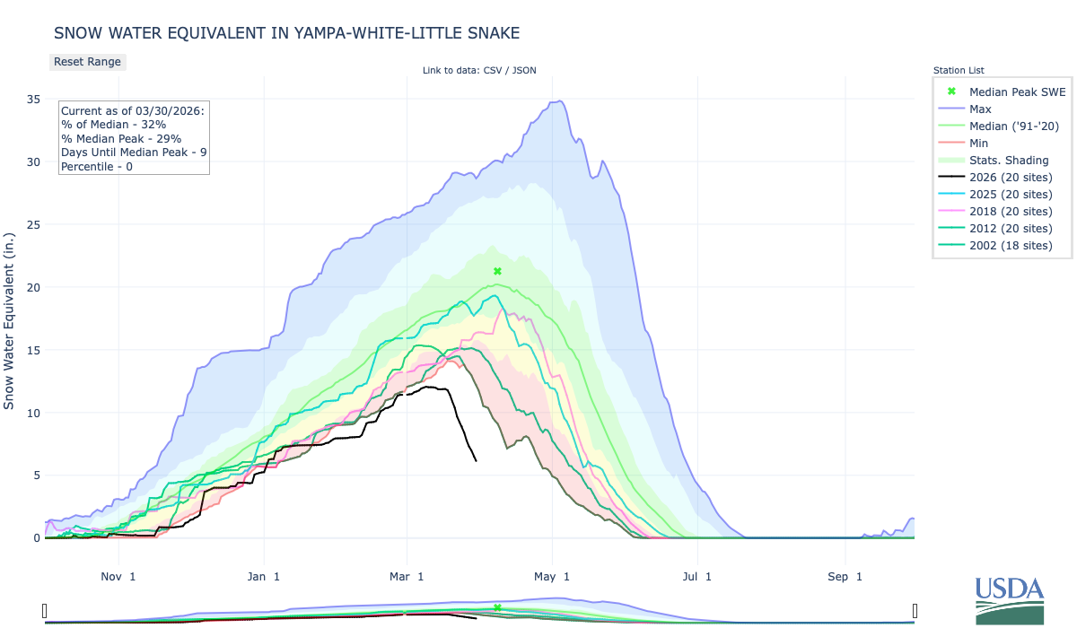
Snowpack
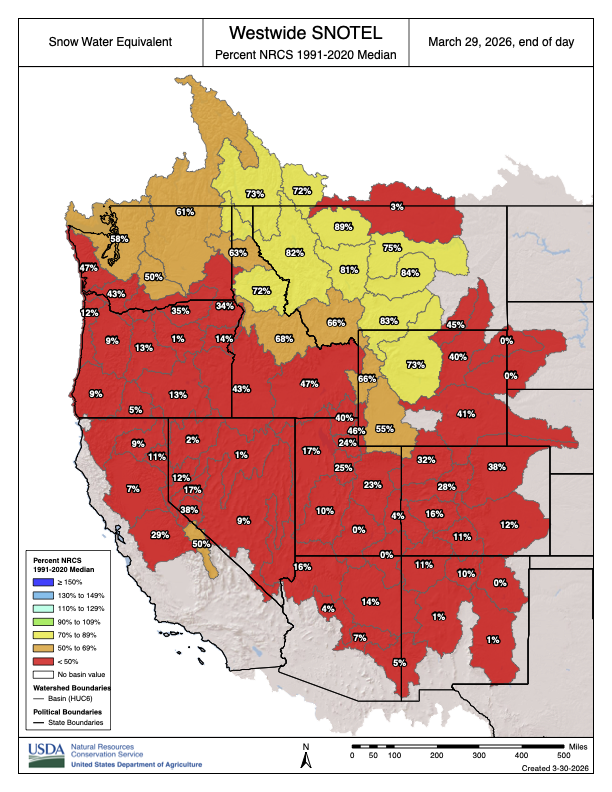
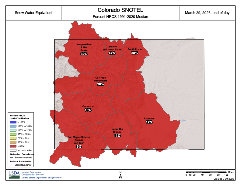
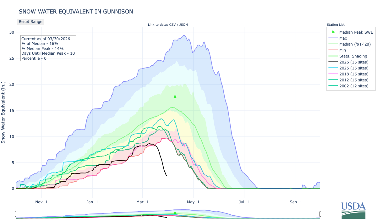
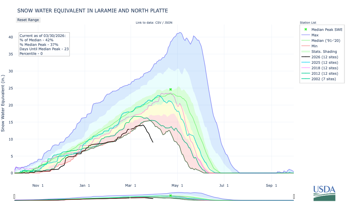
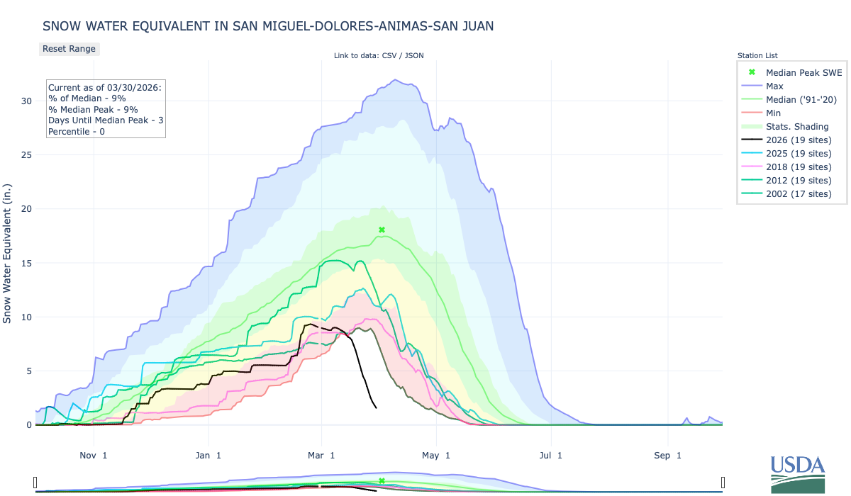
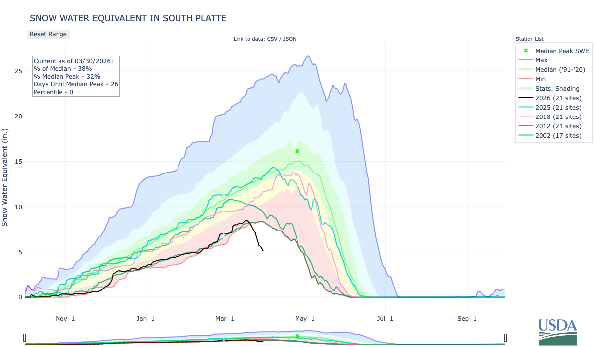
According to data from the Natural Resource Conservation Services (NRCS), as of 11 a.m. on Wednesday, March 25, Wolf Creek Pass at 10,930 feet had a snow water equivalent of 12 inches, compared to that date’s median of 27.3 inches. That amount is 44 percent of that date’s median snow water equivalent. The San Miguel, Dolores, Animas and San Juan river basins as a whole are listed at 21 percent of its 30-year median snowpack. The Wolf Creek summit had the second highest current snow water equivalent in the San Miguel, Dolores, Animas and San Juan river basins, and the Upper Rio Grande basin, behind the Black Mesa site with 12.2 inches of snow water equivalent as of press time Wednesday…
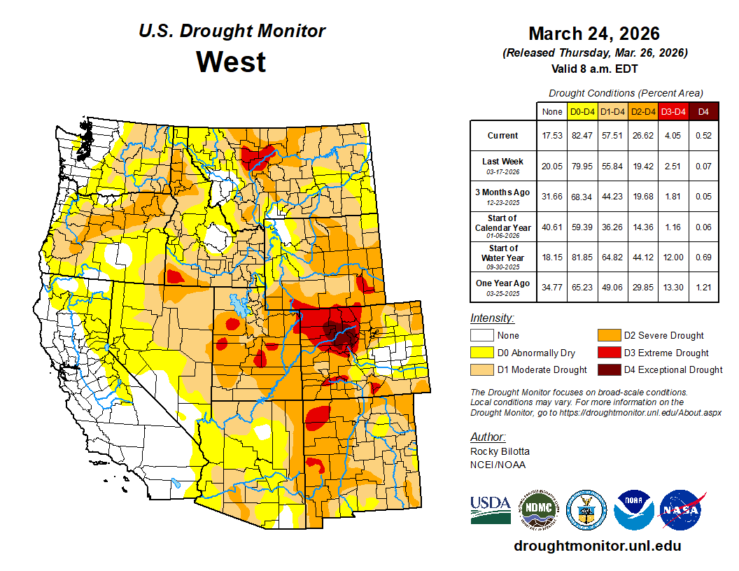
Drought
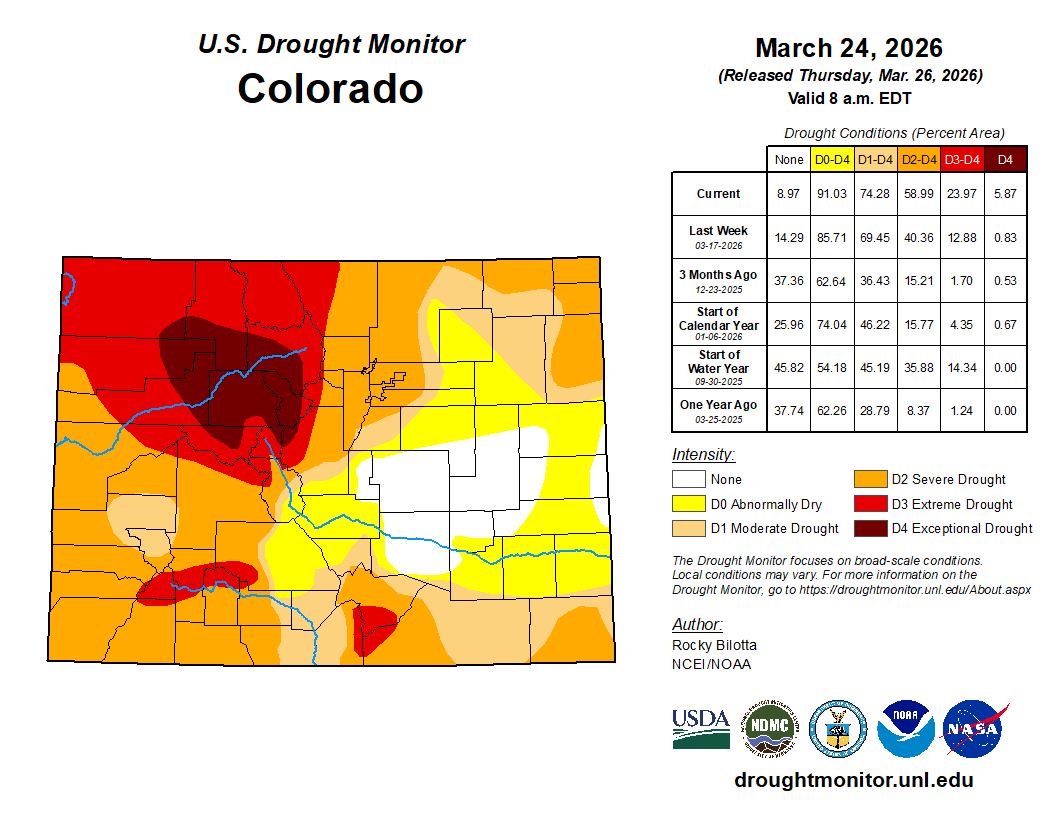
According to the most recent map released by the U.S. Drought Monitor on Thursday, March 19, 100 percent of Archuleta County remains in moderate drought stage, with 22.04 percent of the county being in a severe drought stage. Areas that are in a severe drought stage lie along the eastern border of the county with Conejos County. Meanwhile, 12.88 percent of the state is in an extreme drought stage, and less than 1 percent of the state is in an exceptional drought stage. That includes portions of Pitkin, Eagle, Summit, Lake and Park counties…
River flows
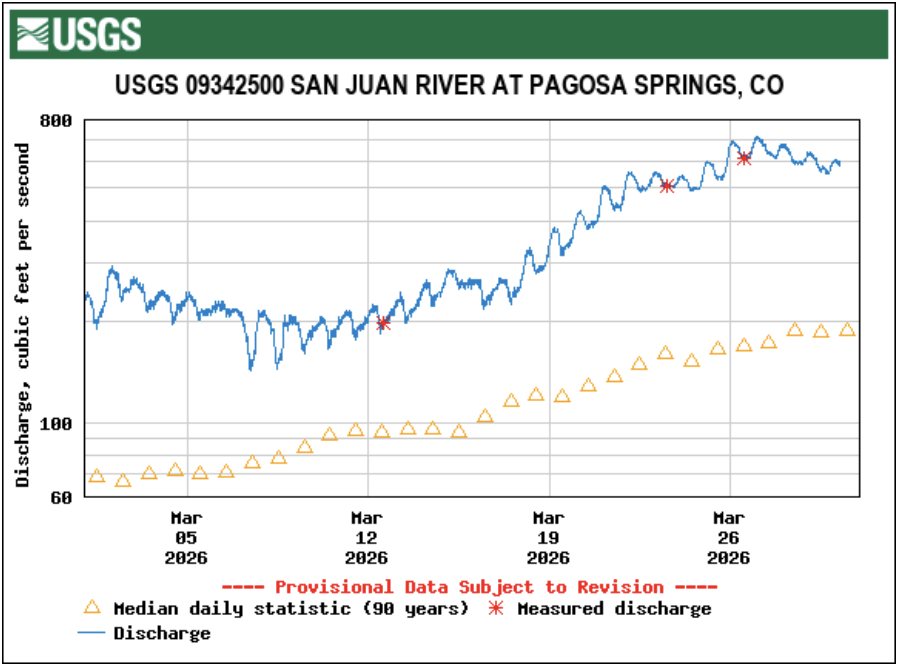
According to the U.S. Geological Survey (USGS), as of 11 a.m. on Wednesday, March 25, the San Juan River in downtown Pagosa Springs had a flow rate of 595 cubic feet per second (cfs). The record high flow for that date was recorded in 2004 at 860 cfs, while the record low was recorded in 1964 at 42 cfs. The median flow for that date is 165 cfs, and the mean flow is 239 cfs. The Piedra River near Arboles was flowing at a rate of 434 cfs as of 11 a.m Wednesday, March 24, according to the USGS. The median flow for that date is 339 cfs, and the mean flow is 457 cfs. The record high flow for that date was recorded in 1993 at 1,400 cfs, while the record low was recorded in 1964 at 45 cfs.