

Bump and update: Here’s the latest snowpack map from the NRCS.
From the Fort Collins Coloradoan (Bobby Magill):
The federal Climate Prediction Center has classified most of Larimer County, including the foothills, and all of eastern Colorado as experiencing a moderate drought. Some areas of Colorado, including Pueblo, Otero, Crowley, Kiowa, Bent and Prowers counties, are in a severe drought.
From The Pueblo Chieftain (Chris Woodka):
The latest release of the U.S. Drought Monitor shows severe drought conditions along the entire Lower Arkansas Valley east of Pueblo and abnormally dry conditions in the Rio Grande basin. Most areas have not seen appreciable rain since midsummer.
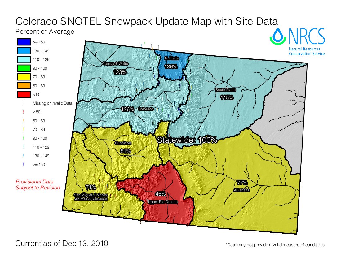
Meanwhile, the Western part of the state is showing above average snowfall early in the season, with some areas showing 150 percent of average for moisture since October, according to the State Water Availability Task Force. A strong La Nina pattern — cooling over the Pacific Ocean — has pushed storm systems to the north, leaving Southern Colorado drier than usual. Snowpack in the Rio Grande basin is the lowest in the state at 77 percent of average, while the Arkansas River basin is at 89 percent, according to the Natural Resources Conservation Service. The good news for Arkansas Basin water users is that the Upper Colorado River basin is at 142 percent. Arkansas River water users rely on imports of water from across the Continental Divide for about one-fourth of the total supply of water each year. Overall, snowpack is at 123 percent of average and the state’s water supply is at 103 percent of average, the task force reported…
Water storage levels throughout the state remain high, the task force reported last week. Reservoir levels in the Arkansas River basin are slightly above average.
Here’s the December 2010 Drought Update from the Colorado Department of Natural Resources (Taryn Huthcins-Cabibi/Veva Deheza). Here’s the executive summary:
Following a warm and dry September and October throughout much of the state, November saw conditions improve in some regions and deteriorate in others. The Rio Grande and Eastern Plains have received little to no precipitation in November and continue to experience moderate to severe drought conditions. The four corners region also remains dry, but has yet to be classified as experiencing drought conditions. Conversely, the northwest portion of the state experienced good precipitation in November alleviating previously dry conditions. Reservoir storage remains strong across most of the state with five of the eight major basins near or above average.
– The eastern plains of Colorado have received below normal precipitation in November and remain below normal for the 2010 water year, which began in October. Much of Northwestern Colorado has seen average precipitation in November helping to ease dryness from the late summer and early fall.
– Recent storms have alleviated dry conditions in The Yampa White Basin. This basin is now at 149% of average for the water year and has a snowpack 129% of average.
– Statewide snowpack is 103% of average. Individually, four of the eight basins are well above 100% of average snow water equivalent. The North Platte has the highest percent of average snow pack at 142%, the Colorado, Yampa/White and South Platte sit at 130%, 129%, and 116% of average, respectively.
– The San Miguel/Dolores and the Rio Grande River Basin remain well below normal for snow pack with 67% and 56% of average. Conditions in the southwest portion of the state will be closely monitored over the coming weeks for emerging drought conditions.
– According to the U.S. Drought Monitor 59% of the state is now experiencing D0, D1 or D2 status, which represents abnormally dry, drought moderate and drought severe conditions respectively. The drought conditions that have covered the eastern plains of the state throughout the fall have continued to deteriorate with D0, D1 and D2 covering much of Colorado east of the divide.
– The December 1st traditional SWSI values range from -1.8 in the Rio Grande Basin to +3.9 in the Yampa/ White/ North Platte Basin.1 The Gunnison and Arkansas basins are both near normal at +0.1 and +0.3 respectively. The Colorado and South Platte are both showing strong positive values at +2.6 and +2.0. The dry conditions in the San Juan/Animas/Dolores/San Miguel are illustrated by a SWSI value of -1.4. The traditional SWSI values are partly influenced by reservoir storage and may not fully represent conditions in the region; the revised SWSI values were not available for this month.
