Forecast news: Winter returns to Colorado this weekend #codrought #cowx

snowflakesbentley.jpg

From the National Weather Service Grand Junction Office:

SNOW WILL INCREASE IN COVERAGE AND INTENSITY SATURDAY AS THE ASSOCIATED COLD FRONT PASSES. SNOW LEVELS INITIALLY BETWEEN 6000 AND 7000 FEET WILL DROP TO VALLEY BOTTOMS SATURDAY NIGHT AND SUNDAY. BEHIND THE COLD FRONT THE UPPER FLOW WILL TURN TO NORTHWEST WITH SNOWFALL FAVORING THE NORTHERN MOUNTAINS INTO MONDAY.

THERE IS STILL SOME UNCERTAINTY ON THE TIMING OF THE STORM SYSTEM AND MOISTURE IS LIMITED. THIS STORM HAS THE POTENTIAL TO PRODUCE SIGNIFICANT SNOW ACCUMULATIONS ACROSS THE REGION ESPECIALLY OVER THE MOUNTAINS. EXPECT MUCH COLDER THAN NORMAL TEMPERATURES THIS WEEKEND AND INTO NEXT WEEK.

From the National Weather Service Pueblo Office:

At the present time, the low is forecast to move from southern Nevada Saturday morning, through the Four Corners region, and into eastern Colorado Saturday night. With this track, areas north of Highway 50 will likely feel the brunt of the system, with mainly windy conditions for the eastern plains south of Highway 50. With windy conditions expected across the region with this low, whiteout conditions could occur at some locations, including northern El Paso County Saturday night. Some uncertainties remain with the track of this low, which could either increase or decrease the chances for precipitation expected over southeast Colorado. Persons planning travel across the region this weekend should remain weather alert and listen for the latest statements or warnings on this developing winter weather situation.

From The Denver Post (Joey Bunch):

The National Weather Service has issued a winter storm watch from Friday evening to Sunday evening for the West Elk and Sawatch mountains, the western San Juans, the Grand and Battlement mesas, as well as the Flat Top range…

The Colorado snowpack has improved slowly since the new year began, but remains at 74 percent statewide, including 69 percent in the Colorado River basin, home to some of the state’s best-known ski resorts and most important reservoirs. Southwest Colorado has a snowpack of 86 percent, and the South Platte River basin, which includes Denver, is at 59 percent, according to the Natural Resources Conservation Service in Lakewood.

How to survive another dry season was the topic front and center at ag show this week in Rocky Ford #codrought

usdroughtmonitor02052013.jpg

snowpackcolorado02072013.jpg

From The Pueblo Chieftain (Chris Woodka):

Farmers and ranchers can make it through a drought by planning ahead, managing resources and making timely decisions. That advice was given to about 150 people who attended the Arkansas Valley Farm, Ranch, Water Symposium and Trade Show Thursday.

“It took me four years to learn what I should have learned in one,” said Huerfano County rancher Grady Grissom. Grissom started the Rancho Largo Cattle Co. in 1995 with a business plan designed to maximize herd size in order to cover his costs.

Meanwhile, if you have water, the good news is that commodity prices for farm products are expected for the growing season. Here’s an report from Matt Hildner writing for The Pueblo Chieftain:

While drought conditions are expected to continue to plague the state this summer, farmers and ranchers who can withstand them will likely see high commodity prices. James Pritchett, an agricultural economist at Colorado State University­Fort Collins, reviewed the economic impacts of the drought and discussed potential impacts during a Wednesday session of the Southern Rocky Mountain Agricultural Conference and Trade Fair. “Farm revenues are going to hit record levels this year on the strength of higher prices,” he said. “So if you have a crop — and not everybody does — and you’re able to stay in production, you’re going to make some money.”

Pritchett and a pair of colleagues have yet to wrap up their surveys on how producers did in 2012 but based on preliminary results, he said operations with lower debt ratios would be in the best position to benefit from high prices for many commodities.

“I think it’s the high-debt folks, I think it’s the dry­land crop producers, I think it’s the cow­-calf producers — those are the ones that are experiencing some of the most difficulties,” he said. His results from 2011 found the San Luis Valley had an above­average year and endured only $4.7 million in drought­related losses. “There weren’t really reductions in irrigation yields and there wasn’t a big change in harvested acres versus planted acres,” he said.

That year also saw little impact on Main Street businesses dealing with agriculture, but he thinks that will change as the drought persists. “In 2011, I don’t think anybody saw the drought coming,” he said. “But if you expect the drought to come, you do adjust your input purchases.”

That could mean farmers and ranchers spend less on pesticides, herbicides and farm equipment.

From Steamboat Today (Tom Ross):

Time is growing short if the snowpack — water content in the standing snow — surrounding Steamboat is to its historic norm by the end of the season, Mage Hultstrand, of the Natural Resources Conservation Service in Denver, said Thursday. She said February and March typically combine to provide 36 percent of annual snowpack, with April contributing another 3 percent. With current snowpack in the combined Yampa/White River basin standing at 47 percent of the annual peak, mountains in the area would have to see 53 percent of the annual snowpack accumulate between now and the second week in April to reach the average.

“The average peak there is on April 11,” Hultstrand said. “To get there in the next two months would take well above-average snowfall for February and March.” Hultstrand is the agency’s assistant snow survey supervisor.

The NRCS reported Feb. 1 that despite heavy snowfall in late January, Colorado’s snowpack was at 72 percent of normal for the date and 10 percent lower than where it stood at the same time in the drought winter of 2011-12.

The combined Yampa/White river basin, which includes most of Routt County, is doing a little better, according to the NRCS, at 77 percent of average and 115 percent of last year’s levels. Another encouraging sign is that reservoir storage across the twin basin currently stands at 103 percent of average for the date.

Focusing on specific locations in the Yampa River Basin, the snow measuring station at 9,400 feet on the west side of Rabbit Ears Pass was showing 11 inches of water contained in 43 inches of snow Thursday, or 75 percent of average for the date. Those 11 inches of water also represent 42 percent of peak snowpack (water content); Rabbit Ears typically peaks at 26.1 inches of moisture April 28.

At the Tower site at 10,500 feet on Buffalo Pass, there currently is 69 inches of snow on the ground containing 19.2 inches of moisture. The water content at the Tower site, which typically holds some of the most robust snowpack in the state, is just 66 percent of the average of 29.1 inches for the date and 37 percent of the seasonal peak.

From the Northern Colorado Business Report (Steve Lynn):

Coming off a pitiful 2012 snowpack, Northern Colorado farmers have worried for months about what this year’s snowpack will portend. Snowpack in the South Platte River Basin hovered at 60 percent of average earlier this month. It has reached only 70 percent in the has reached only 70 percent in the Colorado River Basin.

The National Resource Conservation Service said recently that it expects below-average water supplies this spring and summer in the West, with Colorado especially hard hit. Cities are weighing a range of drought restrictions.

From the Northern Colorado Business Report (Steve Lynn):

The cities of Fort Collins, Greeley and Loveland are considering new restrictions on water use in response to a drought expected to last at least through summer…

In Fort Collins, City Manager Darin Atteberry has the authority to enact water restrictions, though the City Council reviewed the matter earlier this week. The city’s two main sources of water, the Colorado-Big Thompson Project and Poudre River, likely will yield less water this year because of the drought as well as High Park Fire destruction. The city is considering Level 1 water restrictions, which allows watering only two days per week and on a schedule. The restrictions bar watering between 10 a.m. and 6 p.m. and prohibit watering of surfaces such as sidewalks and patios except as necessary for health and safety. The last time the city enacted water restrictions was a decade ago.

Greeley has had water restrictions in place since 1907. It normally only allows watering just three days per week, and no watering between noon and 5 p.m. The city will decide whether to enact tighter drought restrictions in April, when Northern Water issues its quotas, said Jon Monson, director of Water and Sewer. Greeley, like the city of Fort Collins, is concerned that it may have to curb its consumption of Poudre River water because of debris-filled runoff during spring, he added.

City of Loveland officials also are discussing water restrictions, said Gretchen Stanford, customer relations manager for the city’s utility. But like Greeley, Loveland is waiting for Northern Water to make a move. However, Loveland considers itself well-positioned for tight water supplies this year, considering it receives water from Green Ridge Glade Reservoir in addition to the Colorado-Big Thompson project, Stanford said. But next year could pose a problem if the drought wears on. “If we have the same exact summer as we had last year, we would be concerned about 2014,” she said.

Snowpack news: The February 1, 2013 Colorado Basin Outlook Report is hot off the press, read it and weep #codrought

snowpackmapmajorbasinsfebrurary12013nrcs.jpg

Click on the thumbnail graphic for the snowpack map by basins. There is an ugly red splat over the upper South Platte River.

Click here to download a copy. Here’s an excerpt:

Summary

January brought cold temperatures and little moisture to Colorado until the very last week when a significant snow storm hit most of the state. Areas near Steamboat Springs and Durango received upwards of 18 inches during the last week of the January, yet due to the dry start to the month, statewide snowpack ended up being only marginally better than the previous month. Increased snowpack percentages across southwestern Colorado were offset by significant decreases in the northeastern basins and all major basins remain below normal for this time of year. Consecutive months of below average snowpack accumulation are statistically decreasing the possibility of reaching normal conditions by April. Last year’s below average snowpack did not offer any buffer to our current situation. Currently, reservoir storage volumes across the state are at 69 percent of average and 66 percent of last year’s storage. The February 1 streamflow forecasts reflect the below average snowpack conditions throughout the state. The San Miguel, Animas, Dolores and San Juan basins are the only areas in the state where forecasts for April to July runoff volumes improved this month. Water users in all basins should start planning for below average surface water supplies this season. The potential for shortages this season is great.

Snowpack

Snowfall across Colorado was nearly nonexistent for most of January. During this time snowpack percentages were decreasing daily as the gap between current conditions and long-term normals widened. The situation began to improve during late January when storm systems brought much needed moisture to the state. The storms were not enough to tip the scales to normal, but they did help halt the downward slide. Statewide snowpack was at 72 percent of normal as of February 1. The basins that benefited the most from these storms were the basins in the southwest region of the state. The snowpack in the Upper Rio Grande basin increased from from 65 percent of normal on January 1 to 78 percent of normal on February 1. The combined San Miguel, Dolores, Animas and San Juan basins jumped 18 percentage points in January; from 70 percent of normal to 88 percent of normal on February 1. The Arkansas and Gunnison River basins each showed a nominal increase in snowpack percentage compared to last month. The remaining basins in the state showed an overall decline in the percent of normal from what was reported on January 1. The South Platte basin had the largest departure from last month’s report. The snowpack in this basin dropped 13 percentage points this past month, declining from 67 percent of normal on January 1 to just 54 percent of normal February 1.

Precipitation

Precipitation across the state during the month of January was 83 percent of average. Statewide totals were influenced by above average monthly totals recorded in the Upper Rio Grande and the combined basins of the San Miguel, San Juan, Dolores and Animas Rivers. During January the Upper Rio Grande basin received precipitation that was 107 percent of average for this time of year and precipitation in the southwest basins was 120 percent of average. The Gunnison basin came in at 90 percent of average for the month. The remaining basins received between 69 and 72 percent of average precipitation during January with the exception of the South Platte Basin. The South Platte basin recorded just 50 percent of the average precipitation for the month. Year to date precipitation for the state remains below average for this time of year; as of February 1 total precipitation was just 72 percent of average.

Reservoir Storage

Due to last winter’s poor snowpack, reservoir storage volumes continue to track below average levels. At the end of January reservoirs within the state were storing 2,311,000 acre feet of water. At this same time in 2012, reservoirs in the state held 3,606,000 acre feet. Below average storage volumes were reported at the end of January in the Arkansas, Gunnison, Colorado, South Platte, Upper Rio Grande and the combined San Juan, Animas, Dolores, and San Miguel basins. The greatest departure from average was in the Upper Rio Grande basin which reported its reservoirs volumes at just 51 percent of average. The Yampa and White River basins reported reservoir storage to be 103 percent of average and 85 percent of last year’s storage. The storage in the Yampa and White basins may currently be above average, but these basins have the smallest reservoir capacity in the state.

Streamflow

Streamflow forecasts across the state reflect the below normal snowpack conditions measured on February 1. Forecasts for all points across Colorado are calling for below normal seasonal streamflow volumes this spring and summer. The lowest forecasts, as a percent of normal, occur in the Arkansas and South Platte basins. Forecasts in these basins are less than 65 percent of normal and as low as 45 percent of normal for the April to July time period. Forecasts for the Colorado, Gunnison, and Yampa and White basins have declined from those issued last month; expected streamflow volumes in these basins generally range from 50 to 70 percent of normal. As a result of the large snowfall amounts received in January, current runoff forecasts in the Upper Rio Grande and the combined San Juan, Animas, Dolores and San Miguel basins have improved somewhat from last month’s predictions. It is important to note that at this point in the season the mountains have typically accumulated 60 percent of their annual snowpack in Colorado. The potential for recovering to normal conditions at this point in the season is not promising, but it is possible if we see exemplary spring conditions.

La Nada: The latest ENSO Discussion is hot off the press #codrought #cowx

elninolanina.jpg

Click here to read the latest diagnostic discussion from NOAA. Here’s an excerpt:

During January 2013, ENSO-neutral continued, although below-average sea surface temperatures
(SST) prevailed across the eastern half of the equatorial Pacific. While remaining below average, a high degree of variability in the weekly Niño 3 and 3.4 indices was apparent during the month. The oceanic heat content (average temperature in the upper 300m of the ocean) was also below-average, largely reflecting negative subsurface temperature anomalies in the eastern Pacific. At the same time, positive anomalies increased and expanded eastward to the central Pacific by late January. The variability in both the ocean and atmosphere was enhanced during January, at least partially due to a strong Madden-Julian Oscillation (MJO). Consequently, the location of the MJO was reflected in the monthly averages of wind and convection. Anomalous upper-level winds were westerly over the eastern half of the equatorial Pacific, while low-level winds were near average. Relative to December 2012, the region of enhanced convection shifted eastward and became more prominent over Indonesia and the western equatorial Pacific. Despite these transient features contributing to cool conditions, the collective atmospheric and oceanic system reflects ENSO-neutral.

Eagle County: ‘Water Wranglers of the Colorado River’ presentation Tuesday #coriver

waterwranglersgeorgesibley2012.jpg

From email from the Eagle River Water and Sanitation District (Diane Johnson):

Join us next Tuesday as we welcome George Sibley, the author of Water Wranglers: The 75 Year History of the Colorado River District.

Sibley will share the story of the Colorado River, the highly controlled and over-demanded lifeline of the West. Sibley focuses on our steward of the Colorado River, the Colorado River Water Conservation District, while offering interesting perspectives on river projects and entities – and, for that matter, on the history of Colorado.

Tuesday, February 12th
5:30 – 7:00 PM
Walking Mountains Science Center

More Colorado River Basin coverage here and here.

Adams County stormwater fees foment a rebellion of sorts from residents

floodplain.jpg

From the Commerce City Sentinel-Express (Gene Sears):

Hundreds of angry property owners gathered Jan. 24, incensed over a county mandate to implement a stormwater utility and the soaring fees accompanying the measure. Those fees, levied against impervious surfaces on each property, resulted in annual payments due to the county in many cases in the hundreds of dollars where none existed before.

Promising “total transparency,” Adams County Deputy Administrator Todd Leopold addressed the throng, reassembled in a maintenance bay after overflowing a classroom at the station. Both Leopold and Adams County Stormwater Coordinator Andrea Berg shared the floor, taking questions while providing details of the project’s implementation. The pair faced a tough crowd, disillusioned by county efforts to inform and involve residents in the process leading up to levying what most see as a tax on their property.

The county says it adopted the fee schedule in response to an unfunded Environmental Protection Agency mandate, with the funds collected to “address water quality regulations, capital improvement drainage projects and flooding to the maximum extent practicable. Often drainage problems are not easily attributed to a single source, and are usually the result of a combination of things that increase the amount of impervious surfaces (roads, driveways, and development) and affect water quality (erosion, fertilizers, and petroleum products).”

Critics see it as a carefully crafted tax to boost revenues more than $5 million annually, on the backs of unincorporated residents with little or no recourse.

Most rancorous was the estimation of fees owed, which most saw as wildly inaccurate in relation to their actual impermeable surface areas. Some claimed hundreds of dollars assessed on properties with no impermeable surface whatsoever, such as farm fields and pasture. Taken from aerial surveys, the estimations were based largely on shading of roadways and rooftops, with a clear margin of error. The estimations ran into hundreds of dollars per year for properties with rooftops similar in size to suburban homes.

More stormwater coverage here.

Turquoise Reservoir and Twin Lakes operations update

twinlakeswikipedia.jpg

From email from Reclamation (Kara Lamb):

Still hoping for snow this weekend. In the meantime, we started moving water from Turquoise Reservoir down to Twin Lakes today, February 8. We’re moving it through the Mt. Elbert Conduit. We are sitting below average in storage for this time of year at both reservoirs. Water moving through the Conduit also moves through the Mt. Elbert Forebay and generates hydro-electric power at the Mt. Elbert Power Plant before entering Twin Lakes.

Meanwhile, Ms. Lamb has started blogging at kara lamb. Check out her first post That Doesn’t Hurt, i.e. The Joy of Sport where she examines the pervasiveness of pain and injury in sports. Kara is a sports fan. She often does play by play via her Twitter account @klamb.

More Fryingpan-Arkansas Project coverage here.

San Luis Valley irrigators await CRP funds ahead of fallowing land

slvdischargerecharge.jpg

From The Pueblo Chieftain (Matt Hildner):

Groundwater irrigators in the San Luis Valley are awaiting a pair of approvals for a federal program that would pay some to retire farmland and conserve water use. Tim Davis, a consultant for the groundwater subdistrict that hopes to fallow 40,000 acres in the northcentral part of the valley, said Thursday that Secretary of Agriculture Tom Vilsack still must authorize the Conservation Reserve Enhancement Program for the area. Moreover, the White House’s Office of Management and Budget also must authorize spending for the program, which could send up to $109 million in federal funds over 15 years to subdistrict farmers who fallow land. “We’re getting very close to putting this thing on the ground,” Davis told farmers at the Southern Rocky Mountain Agricultural Conference and Trade Fair.

The subdistrict, which is entering its second year of operation, would add up to $27.3 million in fallowing payments over the same period. The subdistrict was designed, in part, to reduce the use of groundwater from the unconfined aquifer, which is at its lowest level since monitoring began in the 1970s. The federal payment would be $175 per acre per year and allow farmers to use 18 inches of water over a 36­month period to establish a cover crop. The subdistrict also would pay a share but will include bonuses to farmers who choose to fallow and sit just north of the Rio Grande between Monte Vista and Del Norte. The subdistrict’s goal there is to restore a groundwater formation known as the hydraulic divide, which it hopes will reduce losses to the river caused by groundwater pumping.

More San Luis Valley groundwater coverage here and here.

Snowpack news: Colorado Springs to implement watering restrictions? #codrought

snowpackcolorado02072013.jpg

usdroughtmonitor02052013.jpg

From KOAA.com (Bill Folsom):

For the Arkansas River Basin, which is a big water contributor to southern Colorado, the snowpack is more than 40% behind where it needs to be. “Right now everything looks pretty bleak. Everybody is seeing the really low numbers, the really low snowpack and expecting very low run-off,” said [Abby Ortega].

Water managers with Colorado Springs Utilities are scheduled to present a water restriction plan next week. It is up to the Colorado Springs City Council to make a decision.

From The Mountain Mail (James Redmond):

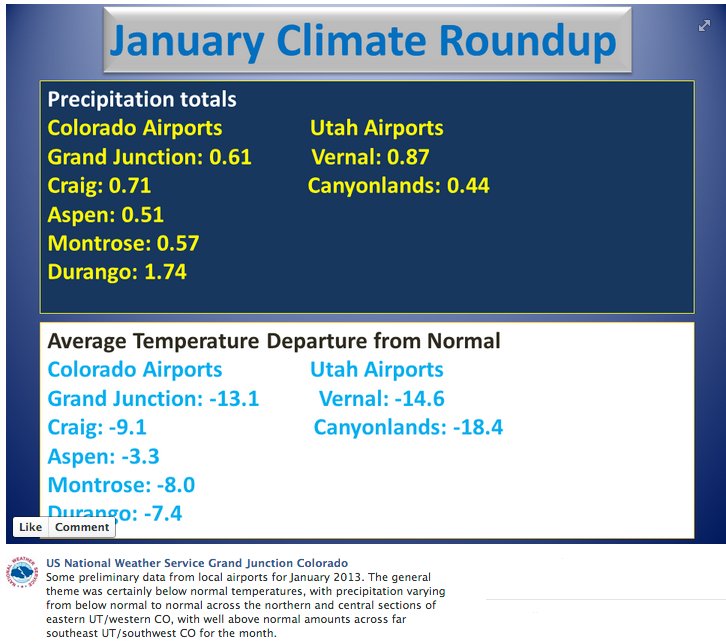
Typically this time of year the mountains receive an inch of moisture a week, yet weekly totals through Jan. 23 mostly ranged from 0.1 to 1 inch along the Western Slope, with a few isolated pockets receiving 1 to 2 inches, the Water Availability Task Force’s January drought update reported…

Despite beneficial moisture in December that boosted snowpack to 70 percent of normal, a very dry January has resulted in snowpack declines in all of the state’s major river basins since Jan. 1. In Salida January yielded only 0.01 inch of precipitation throughout the entire month. January usually has an average precipitation of 0.33 inch, historical Mountain Mail records show…

If the Chaffee County area has a drought this year similar to last year’s conditions, “that would be a record,” Terry Scanga, Upper Arkansas Water Conservancy District manager, said Jan. 31. This area has never seen two back-to-back drought years of last year’s severity, he said. If the drought continues, irrigation rights will see the impact first, probably near July…

For the first time in 9 years, ENSO-neutral conditions are likely to dominate through the winter months, which means neither El Niño nor La Niña is influencing weather patterns. Without their influence, it is difficult to determine when the current drought regime will be broken in Colorado, the Water Availability Task Force report said. While a strong intraseasonal event could help transition back to El Niño by spring, it could also bring additional moisture before then, Klaus Wolter reported Jan. 23 to the Colorado Water Conservation Board Water Availability Task Force. “There is currently no capability to predict such an event more than a week or two in advance. There is nothing on the horizon for now, despite one brief flicker of hope earlier this month,” he said…

Positive AMO and negative PDO values go a long way toward explaining our dry fall and early winter. Given the continuing PDO-AMO setup for drought, pessimism remains justified for at least the next few months, he reported.

From the Summit County Citizens Voice (Bob Berwyn):

January 2012 will go down as one of the driest Januaries on record at the official National Weather Service site in town, where long-time observer Rick Bly measured just 6.55 inches of snow for the month. Bly said that total was one of the five lowest January readings in the books. Going back more than 100 years, the average January snowfall in town is nearly two feet. The little bit of snow that did fall during the month was also excruciatingly dry. Bly said the snow-water equivalent was just 0.11 inches, compared to the historic average of 1.53 inches. That means precipitation for the water year to-date (starting Oct. 1) is just 60 percent of average.

Snowfall for the year to-date is also lagging well behind last year, at 43.85 inches. Normal for this time of year is 78 inches. Last winter, Bly had tallied 62 inches by this time of year…

The best hope of getting out of the current drought conditions is for a super-wet February or a March miracle, which isn’t out of the question — the early 2000s drought was at least partly busted by a mid-March storm that dropped more than seven feet of snow on some parts of the Colorado mountains. But an average February (23.5 inches in Breckenridge) wouldn’t even bring the snowpack back to normal, and have there’s no guarantee that late winter will deliver relief.

Meanwhile, New Mexico snowpack is in very bad shape. Here’s a report from John Fleck writing for the Albuquerque Journal. Here’s an excerpt:

Farmers who depend on the state’s rivers for their irrigation water are preparing for the worst after new forecast numbers call for abysmal runoff for a third year in a row. “The bottom line is, that sucks,” said Phil King, a New Mexico State University professor who serves as an adviser to the Elephant Butte Irrigation District, after seeing the latest forecast for runoff headed his way. The agency provides water for farmers in Doña Ana County, New Mexico’s largest agricultural producer.

While there is still uncertainty about how wet or dry the next few months will be, the mostly likely runoff, if we get normal precipitation through spring, is 39 percent of the long-term average flowing into Elephant Butte Reservoir, according to forecasters at the U.S. Department of Agriculture. In a normal year, the Elephant Butte Irrigation District begins running that water through its system as early as late February, with an irrigation season that runs through October. This year, farmers shouldn’t expect to see any irrigation water until the first of June, and the district could run out by the end of July, King said Wednesday.

From The Grand Junction Sentinel (Dennis Webb):

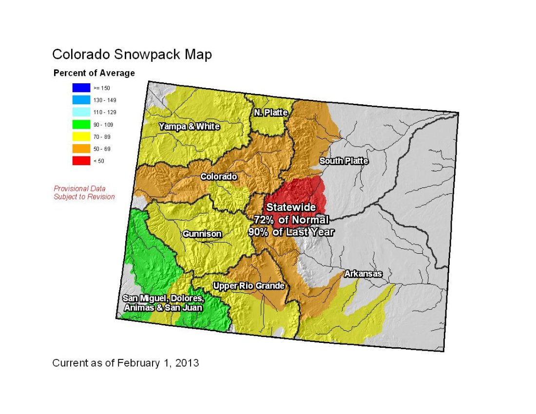
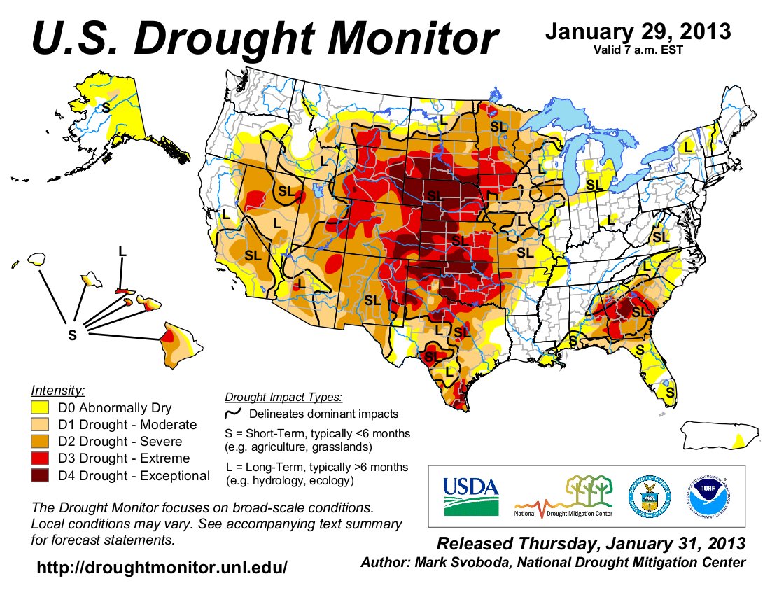
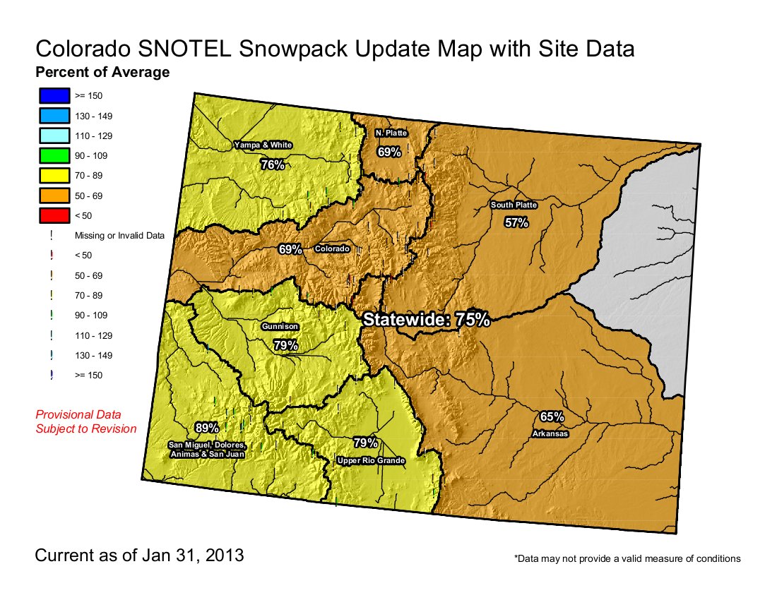
Late-January precipitation in Colorado salvaged the month, but statewide snowpack budged little from where it was at the year’s start, the Natural Resources Conservation Service said this week.

Mostly dry, high-pressure weather systems persisted for much of the month before the arrival of a storm that particularly benefited southwest Colorado, the agency said. As of the start of this month, the statewide snowpack was 72 percent of normal and 90 percent of the same time last year, which ended with snowpack well below average.

Statewide snowpack had been 70 percent of average Jan. 1.

The recent moisture boosted snowpack in the combined San Miguel, Dolores, Animas and San Juan basins to 88 percent of normal, up from 70 percent a month earlier. The Rio Grande and Arkansas basins also saw gains in snowpack. “With the storms focused mainly in the south, the northern portion of the state saw snowpack percentages remain constant or decline during January,” the NRCS said.

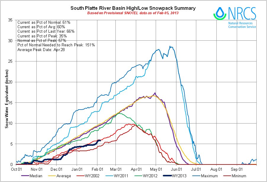
The South Platte fared the worst, dropping 13 percent, to 54 percent of normal, the state’s lowest. The Colorado basin was at 67 percent at the month’s start, which is 89 percent of the same time last year. The Gunnison started the month at 75 percent of average.

“This recent snowpack data directly reflects what the state can expect for surface water supplies this coming spring and summer,” the NRCS said in its release. “Current streamflow forecasts continue to point towards well below normal runoff volumes in all the major river basins in Colorado. Adding to this bleak water supply outlook, reservoir storage across the state remains below average. Unless Colorado sees weather patterns that bring above average snowfall and precipitation to the state over these next few months, it is not likely that there will be much relief from the current drought conditions.”

Statewide reservoir storage is at 70 percent of average, and 63 percent of the same time last year. The Colorado basin’s storage is at 67 percent of average and 59 percent of last year. For the Gunnison, those figures are 72 and 61 percent, respectively. The San Miguel, Dolores, Animas and San Juan basins are still at just two-thirds of average.

The National Integrated Drought Information System said in its weekly report, “Though recent beneficial snowfall has accumulated in the higher elevations of southwest (Colorado), benefits may only be short term. These areas are still running large precipitation deficits from last year.”

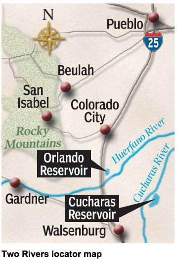
From The Delta County Independent (Hank Lohmeyer):

Surface Creek Valley water managers began looking ahead during last year’s dry spell and made plans to help ensure there will be supplies of water available for domestic providers if a second low-snowpack year is in store for 2013.

During last week’s water forums in Orchard City and Cedaredge, Austin Keiser, president of the Grand Mesa Water Conservancy District board, announced that the district had held back reservoir water for domestic use this year if needed. Keiser explained to the Delta County Independent that a survey of domestic providers last year determined they might expect to draw 480 acre feet from their reservoir reserves on Grand Mesa during 2013. So, to provide an additional backstop for that use, the district has held 500 acre feet in reservoir storage as a down payment against the chance reservoirs may not fill with snowpack runoff this year.

The announcement may help quell any concerns the valley’s domestic water users have about available supply during the coming summer months.

From the Glenwood Springs Post Independent (Scott Condon):

As of Wednesday, the snowpack at the headwaters of the Roaring Fork River east of Aspen was at 50 percent of average, the conservation service reported. For the Roaring Fork River basin as a whole, which includes the Fryingpan and Crystal river drainages, the snowpack is 68 percent of average. The highest snowpack within the Roaring Fork drainage is at McClure Pass and North Lost Trail outside of Marble, according to the conservation service. The snowpack at McClure Pass is 83 percent of average while it is 80 percent at North Lost Trail. This winter is starting to make last winter look good, at least at the headwaters of the Roaring Fork River. The snowpack east of Aspen on Wednesday was only 71 percent of the level on the same date last year…

Two of the traditionally snowiest months for Colorado are still to come, but time is running out. Colorado’s mountains usually accumulate about 60 percent of their snowpack by Feb. 1, Mage Hultstrand, assistant snow survey supervisor for the conservation service, said Wednesday. Another 20 percent of the snowpack usually accumulates in February and 20 percent in March. The below average snowpack produces a “bleak” water supply outlook, the conservation service said. “Current streamflow forecasts continue to point towards well below normal runoff volumes in all the major river basins in Colorado,” according to the agency. Reservoir storage across the state is below average, the agency noted. Ruedi Reservoir was 61 percent full Wednesday and Fryingpan Valley has weak snowpack levels.

From The Greeley Tribune (Eric Brown):

A federal agency this week released statistics detailing the low reservoir levels in the South Platte basin, but one regional water expert had a simpler way of getting the point across. “Compared to how much water we had in storage at this time last year, we’re now short two entire Horsetooth reservoirs,” said Brian Werner, public information officer at the Northern Colorado Water Conservancy District in Berthoud, referring to the 157,000­acre­feet bucket near Fort Collins.

Werner then used a simple adjective to describe the region’s water supplies. “It’s ugly,” he said of the situation facing many, including the Northern Water district, whose Colorado­Big Thompson Project provides supplemental water to more than 640,000 acres of irrigated farm and ranch land and about 850,000 people in northeastern Colorado, including Greeley residents. Werner made those remarks Wednesday — a day after the Natural Resources Conservation Service released statewide reservoir­storage numbers and snowpack figures for Feb. 1. According to the numbers, the South Platte River basin’s collective reservoir storage was 82 percent of the historic average for Feb. 1, and just 67 percent of what it was a year earlier.

While the situation isn’t great, it’s not dire, some local water officials say. Eric Reckentine, deputy director of water resources for the city of Greeley, said Greeley’s water storage is still “adequate to meet demand this year.”

But without abundant snowfall in the mountains in the near future, there will be challenges. The region’s reservoirs filled to high levels following the historic snow year of 2011, but much of those supplies were used up last year as northern Colorado, like much of the U.S., went into drought. With Mother Nature offering little moisture, cities and farmers relied on stored water. Now — in addition to having the equivalent of two less reservoirs to work with compared to last year — snowfall in the mountains isn’t on pace to replenish the area’s reservoirs when spring runoff rolls around.

NRCS reports showed that snowpack in the South Platte basin — which melts in the spring to refill northern Colorado cities’ reservoirs and farmers’ irrigation ditches — was 54 percent of the historic average, and 58 percent of where it was at this time last year. In the Colorado River basin, where the Front Range and other northern Coloradans also get some of their water supplies, snowpack was 67 percent of average, and reservoir storage, too, was 67 percent of historic average.

Werner, with Northern Water for more than 30 years, said if snowfall is limited for the remainder of the winter and spring, Northern Water officials — who will set a quota in April to determine how much of their water can be used — will be in a tough spot. Spring planting for farmers begins in April, and if it’s dry then and looking to stay that way, farmers will likely want a high quota set, Werner noted, to ensure they have enough water for the growing season.

At the same time, though, Werner said Northern Water officials will have to keep an eye on the future, and make sure some of their stored water will still be around the next year if drought persists. “Bottom line; we just can’t take many more 2012s” Werner said.

Like Werner, other water officials — like Harold Evans, chairman for the city of Greeley Water and Sewer
Board, and Lynn Fagerberg, a farmer near Eaton who serves as board president for a pair of irrigation ditch companies — are in wait­and­see mode until April. “After March, you really have a good idea of what you’re going to be dealing with the rest of the year,” Evans said. “Right now, we’re hoping for big snowstorms that can get us back up to normal.”

From The Chaffee County Times (Casey Kelly):

From January through December last year, Chaffee County only recorded a total of 16.7 inches of snow. That isn’t even half of the 44.9 inches the area receives on average each year.

‘Drought rivals the mid 1950s & is likely to get worse before it gets better’ — Brian Bledsoe #codrought

Forecast news: Eastern plains to mostly be left out of the moisture from the upcoming weekend storm #codrought #cowx

Say hello to the ‘Water is your business’ website from the National Association of Water Companies

waterisyourbusinesscirculatorysystem.jpg

From The Age:

The “Water is Your Business” site went live today, sponsored by the National Association of Water Companies and US Chamber of Commerce. It urges companies to stop neglecting infrastructure upgrades as water use for energy and electricity production doubles worldwide in the next 25 years, according to International Atomic Energy Agency forecasts.

“The water leaked across the nation every day could supply California,” the campaign says, describing a supply network that’s 30 times the length of the US national highway system as “outdated, overused and underserviced.”

In the US, most of the water infrastructure dates from the first half of the 20th century. Some pipes go back to Civil War days. The average age of a broken water main is 47 years, with almost a quarter of all water mains more than 50 years old, according to the website.

Maintenance delays mean 45 percent of all pipes were described as in “poor shape” in 2010, up from 10 percent in 1980, according to the campaign, which said the country has “outgrown” the system.

More infrastructure coverage here.

‘The median of a bunch of model runs does not equal a prediction’ — Hannah Holm #coriver

coloradoriverbasin2012doiviatheaspentimes.jpg

From the Grand Junction Free Press (Hannah Holm):

[Last] week, at the Colorado Water Congress annual convention in Denver, water providers and stakeholders from around the state had the opportunity to hear presentations and commentary on some of the study’s finer points and limitations. Here are a few of the key messages that came through in that discussion.

THE LOWER BASIN IS ALREADY IN A PICKLE
Lower basin water users, those that pull water from the Colorado River downstream from Lake Powell, are already using more water each year than they have a right to expect under the terms of the 1922 compact that divided the river between upstream and downstream users.

That’s because the upper basin states, including Colorado, have grown more slowly than California and Arizona, and have consequently allowed more water to flow downstream than is legally required. That’s why there’s still a debate in Colorado about how much more water can be taken out of the Colorado up here, despite the fact that basin-wide, uses are already exceeding supplies.

ENVIRONMENTAL AND RECREATIONAL FLOWS ARE VERY VULNERABLE
The study included modeling different supply and demand scenarios and management actions to see how they would affect the likelihood of hitting key indicators of shortages, both for human water users (levels in Lake Mead, for example), and the environment (low flows at key points). Projecting out toward 2060, the models indicate increasing numbers of years when fish are likely to be in trouble. Some of the management tools appear to have promise for reducing this vulnerability, but no actions would eliminate it. The study also showed that flows too low for enjoyable (and profitable) whitewater recreation were also likely to become more frequent.

THE MEDIAN OF A BUNCH OF MODEL RUNS DOES NOT EQUAL A PREDICTION
Several panelists made the point that climate change models, downscaled to fit the Colorado Basin, produce many different projections of water supply. The median of all the outputs shows water inflows to the basin reduced by 9% by 2060, but that doesn’t mean that this is what will actually happen.

More Colorado River Basin coverage here and here.

Snowpack news: South Platte Basin snowpack is tracking the 2002 line #codrought #cowx

southplattebasinhilow02052013.jpg

southplattebasinhilow09302003.jpg

Click on the thumbnail graphics for a trip down memory lane. I’ve posted the snowpack graphs for the South Platte River Basin from yesterday and for water year 2003. Check out the boost in snowpack from the record-setting snowstorm that started around St. Patrick’s day in 2003. Reservoir storage was very low after the 2002 drought episode and many water suppliers talk about how that one storm saved the day.

From the Boulder Daily Camera (William Callahan):

With only 0.27 inches of moisture and just 3.7 inches of snow, Boulder was way off normal levels. But 25 other Januarys had less than 4 inches of snow, and 36 other Januarys had less than 0.3 inches of moisture. Just recently, January 2003 had 0.5 inches of snow and 0.9 inches of moisture. So a dry January is seldom noteworthy. However, this year is different because its very dry January was preceded by just 20.4 inches of snow during the last half of 2012. Thus, the seasonal snow total now stands at 24.1 inches, which is just more than 50 percent of normal. Last winter had little snow, but reservoirs remained full. The fear has been that the reservoirs would be drawn down throughout 2012 and that if this winter is also dry, they won’t be replenished, intensifying Colorado’s drought.

At the beginning of January, the statewide snowpack was 70 percent of average, and the South Platte River Basin stood at 67 percent. By Jan. 23, the statewide average had dropped to 61 percent, and the South Platte to 55 percent. At that time, the drought monitor showed 13.5 percent of Colorado at the highest level, 5 (exceptional), 45 percent at level 4 (extreme) and the rest of the state at level 3 (severe). Heavy snows in the mountains during the last three days of the month pushed the statewide to 75 percent, and the South Platte to 57 percent. The U.S. seasonal (through April 30) drought outlook from the National Weather Service’s Climate Prediction Center has Colorado in the middle of a 12-state area where drought is expected to “persist or intensify.”

Drought news: ‘Early in 2002, we did not realize how bad it would get’ — Stacey Chesney #codrought

usdroughtmonitor01292013.jpg

From The Pueblo Chieftain (Chris Woodka):

No water rationing is planned in Pueblo unless drought conditions severely affect flows in the Arkansas River next summer.

The Pueblo Board of Water Works initiated outdoor watering restrictions in 2002, but then increased the amount of water to avoid rationing. The strategy paid off in 2012, a year that was nearly as dry as 2002, because Puebloans did not see rationing.

“The board has made an investment of its customers’ money to allow them to use the water when it’s dry,” said Terry Book, executive director of the water board. “If we put in restrictions, we have to cut off extraterritorial water, and it just snowballs.”

The water board’s budget also is predicated on a certain level of use. Ratepayers are seeing the
benefit of greater-­than-anticipated water use last year in lower bills in 2013. The revenue is necessary to operate, maintain and improve the water system, Book said. “We still encourage customers to use water wisely,” he added.

Pueblo water customers have reduced the amount of water used per account by about 17 percent since 2002, an earlier study showed.

The trigger for restrictions would come if Pueblo’s 1874 water right fell out of priority, as it did in 2002. Water rights are determined by court decrees that recognize when water was first put to beneficial use. Some ditch companies — notably Bessemer Ditch and the High Line Canal — have rights senior to Pueblo’s 1874 decree. Pueblo also has several senior rights, but not with large amounts of water.

Last year, the water board used some of its water in storage to meet heavy demand in late summer and early fall. However, the board still has 27,000 acre­feet in storage and expects to accumulate more during runoff. The board has cut off one-­year leases that provide supplemental agricultural water in 2013 to build up storage.

Here’s a report about the drought panel at last week’s Colorado Water Congress Annual Convention, from Chris Woodka writing for The Pueblo Chieftain:

When customers’ water is about to be cut off, the first impulse might be to use even more.
The solution for one water provider: Normal or nothing. “When we told them we were about to move to the next level, people used even more water,” said Diane Johnson of the Eagle River Water Conservancy District.

She was part of a panel of water providers who shared the lessons learned from the 2002 drought at last week’s meeting of the Colorado Water Congress. Stacey Chesney of Denver Water and Russ Sands of Boulder also spoke. The drought conditions of 2002 are similar to 2012 and could continue this year. Some cities already are in or considering outside watering restrictions.

The Pueblo Board of Water Works is not planning restrictions at this time. In general, the state is better prepared to deal with a short­-term drought, the panel agreed. “Early in 2002, we did not realize how bad it would get,” Chesney said. Following 2002, Denver pushed a goal of 22 percent reduction of per capita water use by 2016 and already has seen a 20 percent reduction, she said.

The latest climate briefing from Western Water Assessment is hot off the press #codrought #cowx

springsummerstreamflowforecastjanuary12013.jpg

Click here to go to the Western Water Assessment website. Click through for all the cool graphics. Read ’em and weep if you’re in Colorado. From the website:

Highlights

  • January precipitation was patchily distributed across the region; western Colorado, southeastern Utah, and north-central Wyoming ended up wetter than average, with most other areas drier than average
  • After storms in the last week of January roughly balanced out dry conditions the rest of the month, snowpacks remain below-average across Colorado and southeast Wyoming, and near- or above-average in Utah and the rest of Wyoming
  • The January 1 forecasts for spring-summer streamflow call for below-average flows in nearly all basins in the region; the February 1 forecasts that have been released thus far show a similarly dry outlook
  • The NOAA CPC seasonal climate outlooks, as well as the “SWcast”, continue to show a slight dry “tilt” for late winter and spring precipitation for the southern half of our region, but the one-month outlook for February has a wet tilt based largely on the storms forecasted for the next week

    January Precipitation and Temperatures, and Current Drought

    January saw a very uneven distribution of precipitation across our region, in both space and time. The first three weeks of January were quite dry, with two systems in the last week generating most of the month’s moisture. Most mountain areas in western and central Colorado ended up with above-average precipitation, as did eastern Utah and north-central Wyoming. Drier-than-average conditions predominated in southern Wyoming and, yet again, in eastern Colorado. The HPRCC Water Year Precipitation map shows that while January aided some areas, most of the region remains drier than average since October 1. Southeastern Colorado is still the driest area in the region, with less than 50% of average October–January precipitation.

    Perhaps the most notable aspect of January’s weather was the cold anomaly over most of Utah and portions of western Colorado, with monthly temperatures more than 10°F below average. Intrusions of Arctic air were followed by upper-level ridging and calm winds, leading to persistent surface inversions. Moab, Utah ended up with a record-cold January monthly average of 8.6°F, or 18°F below normal, and more than 5°F below the previous record. In northern Utah, a particularly strong inversion caused a serious air pollution episode from about the 18th to the 26th.

    The latest US Drought Monitor, representing conditions as of January 29, shows very little change in drought conditions since January 1. The vast majority of the region is still classified in severe (D2) or worse drought: Colorado, 100% (up from 95%); Wyoming, 86% (unchanged), and Utah, 66% (up from 64%).

    Current Snowpack and Streamflows

    The dry first three weeks of January saw regional snowpacks decline with respect to the typical trajectory—especially in Colorado, where this slippage was dramatic. But the final, snowy, week salvaged the month for most basins, bringing conditions close to where they were on January 1 in terms of percent of average. The NRCS Current Basin Snowpack map on February 1 shows that Colorado and southeastern Wyoming basins remain well below to below average. In the rest of Wyoming and in Utah, snowpacks are generally near-average or slightly above average. In Utah’s Wasatch Range, the mountain snowpack slipped to about 85% of average even as the urban areas and foothills experienced above-average snowfall, thanks to “upside-down” storms. The February 1 basinwide snowpack for the Upper Colorado River above Lake Powell was 84% of average, compared to 86% of average on January 1.

    In the maps of current streamflows in the three states, most gages are ice-affected and not reporting, as is normal for this time of year. The Green River near Greendale, UT gage, was in the 40th percentile, at 81% of the median flow for February 1.

    Spring-Summer Streamflow Forecasts

    See the previous briefing for details of the January 1 streamflow forecasts for spring-summer 2013. The general outlook for the region is drier than average, reflecting the snowpack anomalies. The next (February 1) streamflow forecast map should be posted by NRCS (and on the Dashboard) around February 10th; we expect no major changes in the regional outlook from the January 1 forecasts. The Colorado Basin River Forecast Center (CBRFC) has released their official February 1 forecasts here; there are slight improvements in the forecasted flows for the San Juan and Uncompahgre basins compared with January 1, but the forecasts are generally lower elsewhere in the Upper Colorado Basin and eastern Great Basin. IMPORTANT NOTE: While NRCS and NOAA continue to collaborate on streamflow forecasts, the forecast values are no longer being strictly coordinated between NRCS and some of the RFCs, including the CBRFC.

    Seasonal Climate and Drought Forecasts

    The latest monthly Climate Outlooks for February, released on January 31 by NOAA CPC, shows a wet tilt for most of Utah and western Colorado through February, reflecting the weather model guidance showing a tendency towards troughs (= moisture) over that area in the first half of February. It is also consistent with the wet forecast for our region seen in the 5-day QPF for the February 6–11 period. The latest seasonal Climate Outlooks released on January 17 by NOAA CPC continue to show a slight tilt towards drier-than-average conditions for the late winter and spring in the southern portion of our region, with the area of dry tilt covering more of Colorado and Utah than the previous outlooks. The CPC Climate Outlooks continue to show enhanced odds for above-normal temperatures for the winter and spring seasons, consistent with the long-term trend towards warmer conditions. The latest CPC Seasonal Drought Outlook released January 17 projects that the drought conditions across our region will persist, through at least April 2013, with a slight change from previous outlooks, in that some improvement is expected in far northern Wyoming.

    The latest PSD Precipitation Forecast Guidance (“SWcast”), released January 23 for January–March 2013 conditions, continues to forecasts a dry tilt in late winter for most of Utah and Colorado, with the strongest tilt towards dry conditions (>10%) in north-central Colorado—though the model skill is marginal in northern Colorado for this season. A modest tilt towards wet conditions is forecasted for far northern Utah. Overall, this dry outlook for Utah and Colorado is mostly unchanged from the forecast made in November, and is consistent with a continued cold North Pacific (PDO-) in conjunction with a warm North Atlantic (AMO+).

    As has been the case since last fall, the seasonal forecasts are not being influenced by ENSO, since the ENSO indicators continue to show ENSO-neutral conditions—though tipping most recently towards La Niña conditions—and the models in IRI’s mid-January ENSO Prediction Plume show a consensus towards ENSO-neutral conditions continuing through next summer.

    Rafting companies saw big drop in revenue in 2012 #codrought

    raftingarkriver.jpg

    From The Pueblo Chieftain (Tracy Harmon):

    Arkansas River rafting and summer tourism at the Royal Gorge Bridge took a huge hit in 2012. Rafting companies and the gorge posted double­digit drops in visitors in a year marked by the summertime Waldo Canyon wildfire and low Arkansas River flow. Rafting took a nearly 19 percent dive, the worst year since drought­stricken 2002.

    The number of boaters went from 208,329 in 2011 to 169,486 in 2012, according to a report by Colorado River Outfitters Association members Joe Greiner and Jody Werner. The decline in economic impact was not quite as harsh: about 16 percent. The drop­off in boating came during a summer marked by a weak economy, low water levels due to a drought and the wildfire. In 2002, visitation sank to 139,178. The rafting industry credits last year’s better numbers to a marketing push promoting the benefits of lower­flow rafting for first­timers and families.

    The industry’s outlook for this summer is brighter due to a slight upturn in the economy. However, the potential for continuing drought “weighs on the possibility of a full recovery,” the association reported.
    According to the group’s 2012 report: Last summer, the rafting industry brought in $20.5 million in direct expenditures to the Arkansas River corridor and a total economic impact of $52.5 million when factors such as meals, lodging and gasoline are considered. In 2011, the industry created $23.8 million in direct expenditures and $60.9 million in economic impact.

    “Colorado’s whitewater rafting industry took a solid hit in 2012. It was the largest drop we’ve seen since 2002 following similar drought and fire conditions throughout the state,” Greiner said in the executive summary. “The proactive education of consumers regarding the quality of lower water conditions helped improve river use over drought stricken 2002 levels.

    “Many families were able to experience rafting for the first time and consumer reviews were extremely positive regarding the quality of the experience. Although the Arkansas River has guaranteed flow targets that are augmented by large upstream reservoirs, river use was affected by the Colorado Springs (Waldo Canyon) fire,” Greiner reported.

    More whitewater coverage here.

    Sterling: New reverse osmosis treatment plant to be online by late summer

    reverseosmosiswaterplantschematic.jpg

    From the Sterling Journal-Advocate (David Martinez):

    Some unexpected hang-ups have pushed back the time before residents receive the full benefits of the new water treatment plant until late summer. The plant has been filtering the city’s water since November, but the full 80/20 reverse osmosis (RO)-filtered water to regular filtered water mix will eke its way into Sterling’s system over the next several months…

    The water treatment plant will significantly lower uranium and pollutant levels, and significantly drop the hardness of the water.

    Most of the issues crews ran into concerned well and distribution issues, but one stood out: A thick, black, non-cohesive material in the well water was clogging up filters faster than expected. “We don’t know entirely what it is,” said Rob Demis, of Hatch Mott MacDonald, the company overseeing construction of the plant. He brought a bottle of it to show the council, showing it as fine black sediment layered at the bottom of clear ground water. After a couple of shakes, the water turned black and opaque. The material – 20 percent organic material and 30 percent manganese, with traces of other elements, such as iron and silicon – is also odorless, though Demis guessed it would have tasted “metallic” and “bitter.” The manganese gives the material its color.

    The raw water filter running now, which catches sediment down to the one-micron level, has caught the material at the five-micron level. Crews would change the filters every couple of days in November, but it’s since become less prevalent, which Demis credited to the city’s aggressive pipe flushing program. “We don’t know the origin. It may be coming out of the pipes. It may be coming out of the formations,” he said. “The good news now is we’re filtering it.”

    The plant also encountered issues with its distribution system, which wasn’t getting water out of the plant quick enough to the city’s distribution tanks to fill them. Demis said the plant quickly fills Sterling’s north and south tanks but doesn’t reach its west tank. Part of the problem might be buildup in the pipes over the years slowing water flow (like plaque clogging an artery, Demis said), but many of the pipes are also 100 years old…

    The plant had planned on having the ability to pump more than 7,900 gallons of water per minute, but right now it can only pump about 5,500. That means that of the treatment plant’s three pump levels – the third allowing the maximum amount of water to pump during peak use – they can only pump enough water to fulfill the first two…

    Water treatment crews have also been finishing construction on two deep water injection wells, which will deposit treated waste water more than a mile underground. One of the wells was dug at about 7,200 feet underground, as recommended by EPA estimates, while the second was dug to about 6,100 feet.

    Demis said the area’s geology hasn’t been fully explored, so the crew will need to test the area over time.

    More infrastructure coverage here.

    ‘Ski areas’ water rights should be protected from federal infringement’ — Mike McLachlan (HD 59) #coleg

    durangomountainresorttrailmap.jpg

    From The Durango Herald (Mike McLachlan HD 59):

    On Monday, I attended the Colorado Water Congress and met with former Sen. Bruce Whitehead. Later in committee, we had a full discussion about the relationship between U.S. Forest Service attempts to link the ski area permit system to what some people consider an infringement on ski area water rights. One side of the debate wants to make this a full-fledged assault on all levels of the U.S. government. As a legislator who has a significant number of ski areas in his district, I listened earnestly to all the testimony and do understand that the ski areas’ water rights should be protected from federal infringement. Because the bill as currently drafted is so broad and so sweeping, I cannot support it in its current form, but if it is narrowed to the U.S. Forest Service and our Colorado ski area water rights, I will support House Bill 1013…

    On Thursday I also was privileged to attend and participate in a legislative panel at the Colorado Water Congress. As I told its membership, I continue to remain committed to bipartisanship and good government. I fully understand the responsibilities of a Western Slope legislator regarding the protection of our water rights, rivers and streams. It was good to see Sen. Ellen Roberts, Sen. Gail Schwartz, John Porter, Steve Fearn, Barry Spear, Steve Harris, Bob Wolfe, Billy Nesbitt, Frank Kugel and John McClow. I will continue my dialogue with the Colorado Water Congress to ensure that the water rights of the 59th District are fully protected.

    More 2013 Colorado legislation coverage here.

    Forecast news: Scattered snow showers over the western mountains today, weekend storm looming #codrought #cowx

    From the National Weather Service Boulder office:

    For today and tonight:
    A weak weather disturbance will move across the area later this afternoon and evening and lead to a chance of snow showers in the mountains. A cold front will move across northeast Colorado this afternoon and increase upslope flow into the southern foothills and across the Palmer Divide. This will allow for a good chance of snow this evening in those areas with a few inches of snow possible. Further north along the Front Range there will be a slight chance of snow showers this evening.

    For Thursday through Tuesday:
    A winter storm is expected to move into the forecast area starting early this weekend. This system will bring colder temperatures and a threat of accumulating snowfall to all of northeast and north central Colorado. While a few snow showers are expected to develop in the high country by Friday night, snow will become more widespread and possibly heavier Saturday afternoon and Saturday night as the storm moves across the state. The snow will likely taper off from west to east across the area Sunday morning.

    While uncertainty remains regarding the track and strength of this system, potential still exists for several inches of snow. In addition, gusty northerly winds will develop across the northeast plains of Colorado which could produce considerable blowing and drifting snow. People planning travel across the Central Rockies and high plains this weekend should be prepared for potentially hazardous winter driving conditions.

    Drought news: ‘You’ve got to have hope’ — Dale Mauch #codrought #cowx

    snowpackcolorado02052013.jpg

    statewidebasinhilow05052013.jpg

    From The Pueblo Chieftain (Chris Woodka):

    Winter water storage was half of average at the end of January as drought conditions deepened. Under a water court decree, the winter water program allows nine large ditches, as well as two smaller ones, to store water in the winter months for use later in the irrigation season. Storage began Nov. 15 and ends March 15.

    But snowpack in the Arkansas River basin is at only 64 percent of average, while stream flows have been at subpar levels since June. A little more than 45,000 acre-­feet of water were in storage at the end of January, compared with a 20-year average of more than 94,000 acre-­feet at the same time over the last 20 years. Last year at this time there were about 86,000 acre­-feet in storage.

    “It’s a mess. It’s not good,” said Lamar farmer Dale Mauch, who also sits on the Fort Lyon Canal board. “We’ve been battling this since 2002, and we’re looking at running out of water by June 1 if things don’t improve.”

    In a normal year, the Fort Lyon Canal — the largest user of winter water — would wait until river flows drop in mid­ June to begin running water stored in lakes. Last year, in order to start crops, all of the water was run early and gone by June 1.

    The drought, now in its third year, has left soil drier than usual as well, meaning the water won’t go as far. An average or wet spring could improve the outlook, because 2012 started better than 2013, until snow started melting off in March, rather than May.

    “The good news is that a storm could get here by the weekend, and it could be a big one,” Mauch said. “You’ve got to have hope.”

    From the Cortez Journal (Michael Maresh):

    The nearly two inches of rain Montezuma County received from Jan. 25-28 had a positive impact on the high country snowpack, a local meteorologist is reporting. Meteorologist Jim Andrus said before the rain, the snowpack for the region stood at about 50 percent of average for this time of year. After the rainfall, the snowpack stood at 83 percent of the average. While rain fell around the county, snow was falling in the higher elevations.

    “The amount of rain we had at the end of that weekend helped a lot,” Andrus said. “We had a ton of rain last weekend.” On Saturday, Jan. 26 Cortez received 1.19 inches of rain and the liquid amount of moisture from both rain and snow added another .69 inches of precipitation for a combined total of 1.88 inches over the three days…

    The big factor for snowpack is the spring weather. If it’s a warm spring with rain and high winds, the snow would evaporate and the major drought concerns would return.

    From The Grand Junction Daily Sentinel (Gary Harmon):

    An uneven water supply picture has the managers of the three big Grand Valley domestic water suppliers looking anxiously to the peaks in search of new snow, to weather forecasts for hope, and to each other for help.

    The bright spot — and one that could fade quickly in the late winter sun — is the snowpack covering the Grand Junction city water supply, which began February at 98 percent of normal.

    The farther east, however, the lighter the snowpack. Ute Water Conservancy District’s winter storehouse of snow is 75 percent of normal and the Upper Colorado River Basin overall is 77 percent of normal. The latter total is of greatest import to customers of Clifton Water District, which gets its water from the Colorado River.

    The top managers of the three agencies are meeting regularly to prepare for the possibility that a dry winter and spring will force them to take extraordinary measures as the days grow longer and the Colorado River shrinks.

    The specter of another disaster, such as the Pine Ridge Fire last year on the north side of the Bookcliffs, could require measures such as water rates designed to punish high water use, and prohibitions on the outdoor use of domestic water, such as for lawn watering. “We all might be one natural event from having to go to the other entities” for help with water, Clifton Water General Manager Dale Tooker said.

    The three systems all are interconnected, largely as a response to the 1977 drought, but each agency forecasts its water use separately, meaning one would have to use its reserves to help out another provider. That would put unanticipated strains on the water delivery system. The three agencies cover one another “on a handshake,” said Greg Trainor, Grand Junction utility and street systems director. “There are no formal agreements.”

    Another strain could arise if low river flows make it impossible for ditch companies, which serve agricultural interests, to draw water from the Colorado. In those circumstances, residents of subdivisions that use ditch water for their lawn watering, garden-tending and other outdoor uses will invariably start using domestic water for those activities. “Until they get their bills,” Ute Water General Manager Larry Clever said.

    One bright note for Colorado River water users is that the Shoshone generating station is close to calling its full 1,200 cubic feet per second of water down the stream. It hasn’t demanded its full water right for the last several years, Clever said.

    The three agencies would prefer to avoid confrontations with unhappy customers and are beginning to fashion ways of urging residents to hold down water use. No half-measures, such as odd-even watering schedules, are likely to be effective because of the difficulty in monitoring them, Clever said.

    The domestic-water agencies are hoping to work with irrigation-water suppliers to better manage their response to the drought but have yet to drum up enthusiasm, Clever said. “We can make it,” Clever said, “If something happened to one of us, we might have to put restrictions on, but we can make it. But if we get three or four of these (drought years,) we’re in trouble.

    From The Greeley Tribune:

    With dry and warm weather expected to continue, management decisions will be critical for agricultural producers and families to maintain the resource base of their operations, according to Colorado State University Extension specialists. The Golden Plains CSU Extension office is planning to host its Drought Summit webcast series to provide critical drought management information to producers and their families.

    Drought Summit dates, web cast origination locations and topics are:

    » Tuesday, Burlington Community Center in Burlington (Weather updates and crop insurance issues)

    » Feb. 19, Washington County Events Center in Akron (Crop production issues, forage production with limited irrigation, entomology and insect concerns during drought)

    » Feb. 26, Yuma Community Center in Yuma (Livestock production issues, including herd liquidation and tax consequences and livestock disease during drought)

    » March 5, Phillips County Events Center in Holyoke (Managing wind breaks, perennials and ornamentals during drought)

    » March 12, Phillips County Events Center in Holyoke (Range management issues, pasture management, invasive weeds and insects)

    » March 19, Sedgwick County Courthouse Annex in Julesburg (Human resources issues, family financial management and communications)

    From the Northern Colorado Business Report (Steve Lynn):

    City Council is scheduled to hear from Fort Collins city staff on the matter at its meeting Tuesday. The restrictions would take effect April 1 if approved by City Manager Darin Atteberry, said Lisa Rosintoski, customer connection manager for the city. Water restrictions do not need approval from city councilors.

    Level 1 water restrictions allow watering only two days per week and on a schedule. The restrictions bar watering between 10 a.m. and 6 p.m. and prohibit watering of surfaces such as sidewalks and patios except as necessary for health and safety. Level 1 restrictions would not affect water bill rates.

    Officials anticipate having less water this year as snowpack remains well below average and also because of poor water quality in the Cache la Poudre from the High Park fire.

    The National Resource Conservation Service said recently that it expects below average water supplies this spring and summer in the West, with Colorado especially hard hit.

    NRCS: Snowpack Remains Below Average #codrought #cowx

    nrcssnowpackstoragetablefebruary2013.jpg

    Here’s the February 2013 news release (read it and weep) from the Natural Resources Conservation Service (Mage Hultstrand):

    COLORADO’S SNOWPACK REMAINS BELOW AVERAGE

    Denver, CO – February 5, 2013 – Snowpack accumulation during January can simply be summed up as; better late than never! Weather patterns in Colorado were largely dominated by high pressure systems this past month and things remained dry throughout most of January. The storm system that finally brought some snow to Colorado during the last week of January has improved snowpack conditions statewide. Unfortunately these storms were not enough to boost the statewide snowpack to normal conditions. Recent snow surveys conducted by the Natural Resources Conservation Service (NRCS) show that Colorado’s snowpack continues to track below the long-term average, according to Phyllis Ann Philipps, State Conservationist. As of February 1, the statewide snowpack was at 72 percent of normal and 90 percent of last year’s readings at this same time. The statewide snowpack percentage has remained nearly constant for two consecutive months (it was 70 percent of normal on January 1).

    The southwest portion of the state benefitted the most from the recent storms. The greatest increase was measured in the combined San Miguel, Dolores, Animas and San Juan basins whose February 1 snowpack was at 88 percent of normal; up from 70 percent of normal measured on January 1. In the Rio Grande basin the snowpack jumped 13 percentage points this past month, to 78 percent of normal as of February 1. The Arkansas basin also showed overall gains in snowpack percentage, increasing from 61 percent on January 1 to 63 percent on February 1. With the storms focused mainly in the south, the northern portion of the state saw snowpack percentages remain constant or decline during January. The largest departure, as a percent of normal, from last month’s report was reported in the South Platte basin which dropped 13 percentage points. As of February 1 the snowpack in this basin was at just 54 percent of normal, the lowest, as a percent of normal, in the state.

    This recent snowpack data directly reflects what the state can expect for surface water supplies this coming spring and summer. Current streamflow forecasts continue to point towards well below normal runoff volumes in all the major river basins in Colorado. Adding to this bleak water supply outlook, reservoir storage across the state remains below average. Unless Colorado sees weather patterns that bring above average snowfall and precipitation to the state over these next few months, it is not likely that there will be much relief from the current drought conditions.

    Click on the thumbnail graphic for the table of snowpack and storage by basin as of January 31, 2013.

    Weekly Climate, Water and Drought Assessment of the Upper #codrought #cowx

    wyutcoprecipitaionjanuary2013.jpg

    Click here for the summaries for this week. Click on the thumbnail graphic for the precipitation summary.

    James Newberry has been elected the new president of the Colorado River District Board of Directors for 2013 #coriver

    SB13-041 passes agriculture committee — defines firefighting and drought mitigation as beneficial uses #coleg

    stagecoachreservoir1.jpg

    From The Durango Herald (Joe Hanel) via the Cortez Journal:

    Sen. Ellen Roberts, R-Durango, won unanimous support for Senate Bill [13-041] in the agriculture committee. Her bill counteracts a 2011 court ruling on the Yampa River that said reservoir owners can’t get an absolute right to water in their reservoirs unless it is all put to a “beneficial use.”

    Colorado law has a “use it or lose it” approach to water, in order to prevent hoarding or speculation. But legislators and their allies in the water business think the court took that doctrine to an extreme…

    Denver Water CEO Jim Lochhead said that unless the bill passes and reverses the Supreme Court ruling, utilities would have to suck their reservoirs dry before they could get new water rights…

    The bill declares that storing water for firefighting and drought mitigation is a beneficial use, and it says water rights can’t be considered to be abandoned when the water is in long-term storage.

    More 2013 Colorado legislation coverage here.

    Drought/snowpack news: Statewide snowpack = 75% of avg, South Platte = 59% (lowest in state) #codrought #cowx

    snowpackcolorado02042013.jpg

    usdroughtmonitor01292013.jpg

    From The Aspen Times (Janet Urquhart):

    According to weather data tracked by the Aspen Water Department, 80 percent of January’s snow fell during the final week of the month, providing a string of powder days on the slopes and keeping the month out of the top five driest Januarys on record. Still, last month nearly cracked the top 20 with a total snowfall that was well short of average. The Water Department measured 18.3 inches of snowfall at the town’s water plant, located at an elevation of 8,161 feet, for the month. The average is 25.9 inches…

    Last week’s snows helped boost the statewide snowpack to 75 percent of normal thanks to huge dumps that added several feet of new snow to parts of Colorado, including the southwest mountains (Telluride reported nearly 3 feet by Thursday), the Grand Mesa and the Steamboat Springs area…

    Snowpack in the Roaring Fork Basin stood at 63 percent of average on Sunday. It was at 60 percent of average on Independence Pass, southeast of Aspen, and at 76 percent of average on North Lost Trail, outside Marble, according to the conservation service.

    By comparison, the snowpack in the river basins of southwest Colorado — the Dolores-San Miguel and San Juan — stood at 75 and 74 percent of average, respectively. The Yampa/White River basin, including Steamboat Springs, was at 78 percent of average, and the Upper Colorado River headwaters, which encompass ski resorts that include Vail and Copper Mountain, was at 72 percent.

    From the High Country News (Sarah Jane Keller):

    “Normal” climate is often measured in 30-year increments, adapted every decade by many weather-watching organizations. Until recently, Morrisey’s NRCS, whose SNOTEL sites track Western snowpack, used 1971-2000 as its standard. Now, however, it uses 1981-2010, meaning precipitation averages exclude the 1970s’ wet years. Instead, the dry 2000s have replaced them, so this year’s Western snowpack conditions may sound better than they are. This affects far more than peeved powder hounds; irrigators and rafters hoping to avoid parched crops and rocky rivers will have to adjust their notions about what a normal snowpack is.

    ‘I can’t attract investors with water…They are investing in food supply’ — John McKowen (Two Rivers Water Co.)

    cucharasolandoreservoirstworivers.jpg

    From The Pueblo Chieftain (Chris Woodka):

    A water developer who is planning to build reservoirs along the Arkansas River in Pueblo County says his plan is to cash in on the worldwide need for food. “I can’t attract investors with water,” said John McKowen, CEO of Two Rivers Water Co. “They are investing in food supply.”

    McKowen talks about growing vegetables instead of corn and hay as a way to increase farm revenues, but admits he is not a farmer. “I’m a businessman,” he said. “If we can put the right structure together, we can attract the capital.”

    McKowen already has raised about $44 million in the last five years since organizing a company to acquire farmland and reservoirs in Huerfano and Pueblo counties. He has restored farmland under the Huerfano­Cucharas Ditch and under Orlando Reservoir. He bought a farm on the Bessemer Ditch, and is looking for more opportunities.

    If all McKowen’s plans come together, he could create more than 100,000 acre­feet of storage space, which could be used for multiple purposes. He eventually plans to fallow some ground in order to sell some of the water as another source of revenue. He went into the venture knowing nothing about farming, but has found farmers, scientists and water professionals to improve his chances. Two Rivers was able to raise crops profitably during last year’s drought.

    But some in the water community have expressed doubts because he is paying more for water than farmers should be able to pay. “Our first interest is to develop the water so we can support our agricultural interests on the Arkansas River,” McKowen said.

    As for moving water permanently off the river, he flatly says he is not interested. “Moving water somewhere means you’re betting on the developers,” McKowen said. “Every developer I know is broke.”

    Placer mining clubs: ‘We need to work closer with the clubs and a lot of individuals who go out’ — Barbara Sharrow

    suctiondredgewithsedimentplume.jpg

    From The Telluride Daily Planet (Heather Sackett):

    Placer mining on the San Miguel River has recently come under the scrutiny of the Colorado Bureau of Land Management, but not for the methods described above [panning, metal detectors]. What the BLM says it’s worried about are suction dredges, which suck up sediment — and gold — from the river bottom, sometimes creating large holes in the process. The operation consists of a gas-powered dredge pump, hoses and a metal sluice box that filters sediment through screens. Sometimes a prospector will don a wetsuit and regulator and get into the water to help guide the hose.

    BLM Uncompaghre Field Office Manager Barbara Sharrow says last fall her agency discovered several places where placer miners had been digging and dredging into the riverbanks, causing erosion and in some cases resulting in four-by-five-foot pits. If the holes aren’t filled in, the spring runoff causes the river to widen, Sharrow said. Some holes have been dug underneath trees, making it almost certain they will be washed away. The most popular places for placer mining on the San Miguel — and where the most damage is taking place — are near the Piñon River bridge, the Norwood bridge and around the town of Naturita.

    “We are getting into some resource damage there,” Sharrow said. “We need to work closer with the clubs and a lot of individuals who go out. We need to come up with some options.”

    To that end, the BLM is currently researching the issue and is planning on meeting with regional placer mining clubs this winter. Grand Junction and Olathe also have clubs. The meetings will also address claims and Sharrow encourages aspiring miners to get maps from the BLM office in Montrose.

    [Toby Walker] said members of his club are good stewards of the river, and if they dig holes, they fill them in. The club also helps keep the waterways healthy by walking the banks and picking up trash during every outing, he said. “It just gives us all a bad name,” he said. “The people in our club are great. If they dig any holes, they fill them in. There’s always a bad seed that comes in.”

    He said it would be a great idea for the BLM to come and present alongside the geologists, historians and other guest speakers at the group’s monthly meetings. “It would be great if they would come talk to us about the regulations and what they mean,” Walker said.

    Sharrow is not against placer mining. But with gold prices high — an ounce is worth nearly $1,700 — the hobby is sure to continue to attract amateur prospectors. She said the activity has gotten more popular since the economy tanked. “It’s kind of a cool activity I think,” Sharrow said. “We need to work with the folks so we are not damaging the resources and we come to a good place there. That’s my goal.”

    More restoration/reclamation coverage here.

    CoCoRaHS: Easy way to determine the water content of your snow measurement without needing to melt the snow

    High Plains Snow Goose Festival, Feb. 21-24 in Lamar

    snowgoose.jpg

    Here’s the link to the website. Here’s an excerpt:

    We are really looking forward to our 11th Anniversary Snow Goose Festival! We’ve had some great times with good friends! Sunrises, sunsets, good food, silly jokes, fascinating speakers, memorable sightseeing, and of course, birds! Last year we saw 70 species – not bad for February! Thanks to all of you who have taken this adventure with us! We hope we continue to learn and explore together for years to come!

    We are excited about the new programs for 2013! Friday night, experience Music Of the Santa Fe trail with Mark Gardner. Our guest speaker, Richard Crossley is coming a long way to share his passion about birds with us! A new tour to the Blue Rose Ranch, horse rescue ranch and Colorado Birding Trail site is sure to be interesting and give you a taste of the old west. Also with a historical twist, you can have lunch and learn how to cook in a Dutch oven at the Big Timbers Museum. Visit a one room school house, tour Bent’s Old Fort and Bent’s NEW fort! Hear how we discovered where Black Swifts go in the winter. Discover the Wild Lands of Otero County. Other Favorite speakers will be here: Ted Floyd and Dave Leatherman. Two new events are the “Birds of a Feather Art Show” and the “Share the Spirit Photo Contest”. So much to do – hope you can join us! Read more about it in the schedule!

    Here’s the release from Colorado Parks and Wildlife. Click through for the jam-packed schedule of events. Here’s an excerpt:

    Hundreds of bird species migrate through eastern Colorado each year, but the migration of snow geese is by far the most dramatic. Flocks numbering in the tens of thousands make for a spectacular sight.

    Colorado Parks and Wildlife and the Lamar Chamber of Commerce have joined forces to celebrate the majestic snow goose migration with the 11th annual High Plains Snow Goose Festival. The four-day festival kicks off on Thursday evening, Feb. 21 and continues until Sunday, Feb. 24.

    “The snow goose festival is a celebration of an incredible array of wildlife viewing with music, field trips, educational booths, lectures, historical tours, arts and crafts, and a variety of family friendly activities,” said John Koshak, a watchable wildlife coordinator with Colorado Parks and Wildlife.

    “We have an outstanding schedule of events that includes an incredible selection of special programs and presentations,” said Koshak. There is a $15 registration fee for the weekend. Field trips are priced between $10 – 25 depending on the length of the program and if meals are provided.

    “The main stars of the festival,” said Koshak, “are the snow geese.” An early Sunday morning bus tour will take festivalgoers to watch approximately 25,000 honking geese lift-off from local reservoirs and fly to their daytime feeding grounds.

    “Along the way, we might see other birds including bald eagles, hawks, and other wildlife. In past years, people have been lucky enough to see porcupines, owls, coyotes, foxes and many other critters,” said Koshak. “After a morning of wildlife watching, we will stop at the Community Center in Eads for a hot breakfast.”

    Drought/snowpack: ‘I think we’re reliving the ’50s, bottom line’ — Brian Bledsoe #codrought #cowx

    snowpackcolorado01312013.jpg

    usdroughtmonitor01292013.jpg

    From the Montrose Daily Press (Katharhynn Heidelberg):

    If recent heavy rains and snowy mornings have people thinking this year’s water picture might be improving, they should think again.

    The parched region is a long way from turning the corner, according to projections for the Aspinall Unit, which includes Blue Mesa and several other reservoirs in the Upper Gunnison Basin.

    “We’re about halfway through our snow accumulation season, so things could get better, but right now, the Gunnison River Basin is about 62 percent of average for snowpack,” said Erik Knight, hydrologist for the Bureau of Reclamation, which manages the Aspinall [Unit].

    From The Durango Herald (Joe Hanel):

    “I think we’re reliving the ’50s, bottom line,” Bledsoe said Friday morning at the annual meeting of the Colorado Water Congress. Bledsoe studies the famous El Niño and La Niña ocean currents. But he also looks at other, less well-known cycles, including long-term temperature cycles in the oceans.

    In the 1950s, water in the Pacific Ocean was colder than normal, but it was warmer than usual in the Atlantic. That combination caused a drought in Colorado that was just as bad as the Dust Bowl of the 1930s. The ocean currents slipped back into their 1950s pattern in the last five years, Bledsoe said. The cycles can last a decade or more, meaning bad news for farmers, ranchers, skiers and forest residents. “Drought feeds on drought. The longer it goes, the harder it is to break,” Bledsoe said…

    Nolan Doesken, Colorado’s state climatologist, said the summer of 2012 was the hottest on record in Colorado. And it was the fifth-driest winter since record-keeping began more than 100 years ago. Despite recent storms in the San Juan Mountains, this winter hasn’t been much better.

    “We’ve had a wimpy winter so far,” Doesken said. “The past week has been a good week for Colorado precipitation.”

    However, the next week’s forecast shows dryness returning to much of the state.

    Reservoir levels are higher than they were in 2002 – the driest year since Coloradans started keeping track of moisture – but the state is entering 2013 with reservoirs that were depleted last year. “You don’t want to start a year at this level if you’re about to head into another drought,” Doesken said.

    From the Nation Weather Service Pueblo Office:

    A large storm system will move into the central Rockies next weekend. Model forecasts are currently indicating the potential for 3 different storm tracks. If track 1 occurs, some snow is likely over southern Colorado. If track 3 occurs, there could be little or no snow over southern Colorado. If track 2 occurs, there could be a widespread, significant snowstorm over southern Colorado. Unfortunately, with forecast models indicating so many possible storm tracks, it is difficult to have confidence in any one of the forecasts at this time. Stay tuned to your National Weather Service over the next few days. A clearer picture of what to expect should emerge as we approach the weekend.

    House Joint Resolution 13-1044 clears House Agriculture, Livestock and Natural Resources Committee

    powderhornskiarea.jpg

    From the Sterling Journal-Advocate (Marianne Goodland):

    The committee unanimously approved House Joint Resolution 13-1004, which encourages the U.S. Department of Agriculture Forest Service to withdraw a 2012 directive that requires ski areas to turn over their water rights, without compensation, for federal lands leased from the Forest Service.

    HJR 1004 points out that federal law requires federal agencies to abide by the water laws of the states in which federal lands are located. However, according to resolution sponsor Rep. Jerry Sonnenberg (R-Sterling), the Forest Service drafted the 2012 directive in violation of that law, known as the McCarran Act.

    The National Ski Areas Association filed a lawsuit against the Forest Service over the directive, and a Denver District Court judge recently ruled in favor of the NSAA, but only on procedural grounds and not on the substance of the directive. According to testimony in Monday’s hearing, the judge told the Forest Service that “they didn’t do it right” when they issued the directive without public input, a violation of federal administrative procedures.

    Meanwhile, here’s the USFS release about the public meetings this spring (Chris Strebig):

    The U.S. Department of Agriculture Forest Service announced today a public process to develop a directive regarding water rights on National Forest System lands that have ski areas and other permitted uses. The Forest Service plans to begin the public process this spring.

    “Establishing an inclusive process on this important issue will help meet long-term goals,” said Rocky Mountain Regional Forester Daniel Jirón. “Maintaining the water with the land will ensure a vibrant ski industry, and resilient and healthy national forests and mountain communities into the future.”

    Regional Forester Jirón testified today before the Colorado General Assembly House Agriculture, Livestock and Natural Resources Committee at the Colorado State Capitol in Denver. The Committee scheduled the hearing to address water rights and ski areas brought up through Colorado House Bill 13-1013 and Colorado House Joint Resolution 13-1004.

    On December 19, 2012, the United States District Court for the District of Colorado in National Ski Areas Association, Inc. v. United States Forest Service ruled to vacate the 2012 Forest Service directive on ski area water rights. The Court declined to rule on the substance of the Forest Service directive, but indicated the Agency should proceed with public notice and comment for this type of directive.

    The Forest Service Directive System consists of manuals and handbooks that codify policy and provide administrative direction for Forest Service employees to manage National Forest System lands.

    “Together, we can find solutions that support a strong ski industry, keep the water with the land to sustain local communities, and ensure the long-term viability of this unsurpassed winter recreational experience,” said Jirón. “We think it is a good idea to engage the public and communities to map out next steps on this issue.”

    The National Forest System lands comprise 192 million acres of forest and grasslands in 43 states. The Forest Service estimates that downhill skiers and snowboarders at 22 ski areas on national forests in Colorado contribute approximately $1.5 billion annually to Colorado’s economy.

    More 2013 Colorado legislation coverage here.

    The CWCB plans to roll Flaming Gorge Pipeline analysis in with other IBCC reviews for transmountain diversions #coriver

    flaminggorgepipelineearthjustice.jpg

    Here’s an article from last week that deals with the demise of the Flaming Gorge Task Force. It ran in the Grand Junction Daily Sentinel and was written by Gary Harmon.

    From The River Blog (Jessie Thomas-Blate):

    Last year, American Rivers listed the Green River as #2 on our annual list of America’s Most Endangered Rivers®, due to the potential impact of this pipeline on the river, the recreation economy, and the water supply for the lower Colorado River Basin…

    Recently, a coalition of 700 business owners called Protect the Flows commissioned a poll that found 84% of West Slope residents and 52% of metro Denver-area residents oppose building additional water pipelines across the mountains. In fact, 76% of Colorado residents think that the solution lies in using water in smarter and more efficient ways, with less waste…

    The Green River is a paddler’s paradise. In May 2012, Steve Markle with O.A.R.S. told us why paddlers love the Green River so much. Then in August, Matt Rice, our Director of Colorado Conservation, told us about his trip fishing the Green, and the big trout, beautiful scenery, and solitude he found there. Finally, Scott Willoughby with the Denver Post gives a description of the river that makes you jealous if you don’t have easy access to this trout oasis (even if you aren’t an avid fisherman!).

    It is no wonder so many people care about preserving adequate water flows in the Green River. It not only provides essential water and cash flow for West Slope towns, but also a great adventure for the citizens of Colorado and beyond.

    More Flaming Gorge Pipeline coverage here and here.

    U.S. water infrastructure needs: ‘The cost is massive and the cost of not doing it is massive’ — David LaFrance

    justicegreghobbsdavidrobbins2013coloradowatercongressjculrich.jpg

    From The Pueblo Chieftain (Chris Woodka):

    Water infrastructure in the United States is aging and by 2035 could cost $1 trillion to update or replace. Water users should expect to pay higher rates, said David LaFrance, executive director of the America Water Works Association at the closing luncheon of the Colorado Water Congress on Friday.

    “The cost is massive and the cost of not doing it is massive,” LaFrance said. “Household bills will go up as the costs keep coming. AWWA is trying to figure out how to do it so the customers aren’t stymied by costs.” The largest costs of water investment are not the dams, pumping stations and other parts visible to the naked eye, but the pipes buried underground.

    The bulk of that infrastructure was installed after World War II, and will continue to deteriorate, LaFrance said.

    AWWA is working to secure national funding to pay the costs, since 85 percent of the water systems in the U.S. are considered very small. A challenge for larger utilities will be to ensure that costs do not unduly burden poorer customers, he added.

    The group also named Sterling native Diane Hoppe, a former state representative and now a member of the Colorado Water Conservation Board, as the Wayne Aspinall Water Leader of the Year.

    From The Pueblo Chieftain (Chris Woodka):

    One of the high points of a water conference that stressed getting future generations interested in water invoked a figure from a century ago.

    J.C. Ulrich, an engineer who designed Rio Grande Reservoir, read a few of his letters from the period of 1905­ 1912 during construction. He described the surveying work, conditions for the workmen, disputes with contractors and even the quality of food during construction. Well, actually it was Colorado Supreme Court Justice Greg Hobbs in character — complete with a stout black moustache and bowler hat — reading the letters at the Colorado Water Congress Friday.

    Some of the presentations at the conference looked at how younger people can be persuaded to enter careers in water-related fields. Hobbs, a fine actor known for dramatic reading of his own poetry, reprised the role of Ulrich that he created for the 100th anniversary of the reservoir last summer.

    The reservoir’s construction came after an 1896 embargo on building reservoirs in the Upper Rio Grande was lifted. This year marks the 75th anniversary of the 1938 Rio Grande Compact among Colorado, New Mexico and Texas.

    Water attorneys Bill Paddock and Dave Robbins explained how the compact divides water among the states. A treaty with Mexico also affects the river. Disputes over the Rio Grande date back to the 1880s, when a drought, railroad and canal development converged on the upper portion of the river in Colorado. A 1906 treaty lifted the embargo and allowed the construction of the reservoir.

    More infrastructure coverage here.

    Colorado’s Green Industry Donates $100,000 to Support CSU Horticulture Research

    moongarden051108.jpg

    From Colorado State University (Jennifer Dimas):

    Leaders of the state’s green industry – encompassing all the plant producers and professional services that bring to life yards, gardens, golf courses and public spaces – have donated nearly $100,000 to Colorado State University for research in the Department of Horticulture and Landscape Architecture.
    The donation will be invested, and annual earnings from the endowment will provide a steady flow of research funding for many years to come.

    A group of Colorado industry associations jointly provided the gift. The group has annually funded research for nearly four decades; the endowment will allow a continuation of this support in perpetuity.
    The funding will continue to bolster research of special interest to the green industry, said Stephen Wallner, head of the Department of Horticulture and Landscape Architecture.

    “This research support is a nice example of partnerships our department and land-grant university have with Colorado agriculture. Our department is pleased to support industry needs with new discoveries, which ultimately help not only producers, but also home and public gardeners,” Wallner said. “We particularly appreciate this dependable research funding, which will continue in perpetuity.”

    Donna Ralston, former executive director of the GreenCo Foundation and a leader in providing the donation, said the green industry is especially interested in research that suggests solutions to water scarcity for lawns and gardens.

    “Most of the issues in the industry revolve around water conservation, water use and plants that are more drought-tolerant in our semi-arid climate. We’re interested in understanding everything from plant varieties to better irrigation techniques,” Ralston said. “Our industry continues to evolve, and research findings are critical to that.”

    The green industry is a critical component of Colorado agriculture.

    Total revenues for the green industry were estimated to be about $1.8 billion dollars in 2007, according to the most recent economic survey. The green industry provided almost 35,000 jobs with $1.2 billion dollars in payroll, the survey showed.

    The industry encompasses the following sectors: landscape architecture, landscape contracting, nurseries and greenhouses, garden centers, sod production, lawn care professionals, and tree and shrub care.
    “By donating these assets to an endowment established through the CSU Foundation, we can continue to support horticulture research that benefits the entire green industry for years to come,” said Troy Sibelius, former president of the GreenCo Foundation.

    Lake Mead: Quaggas have become the dominant lake-bottom organism #coriver

    zebramusselinfestation.jpg

    Here’s a report about the recent USGS assessment of water quality at Lake Mead, from Bob Berwyn writing for the Summit County Citizens Voice. Here’s an excerpt:

    Overall, the U.S. Bureau of Reclamation said that Lake Mead’s water quality is good and that fish populations are holding their own. Lake Mead is even providing habitat for an increasing number of birds. But the report also acknowledges that invasive quagga mussels have become the dominant lake-bottom organism, posing significant threat to the Lake Mojave and Lake Mead ecosystems. The report also acknowledges the long-term threat of climate change, which will bring reduced water supplies to the entire Colorado River Basin.

    “While the Lake Mead ecosystem is generally healthy and robust, the minor problems documented in the report are all being addressed by the appropriate agencies, and are showing substantial improvement since the mid 1990′s,” said U.S. Geological Survey hydrologist Michael Rosen.

    Major findings detailed in the report include the following:

  • Basic water-quality parameters are within good ranges of Nevada and Arizona standards and EPA lake criteria. Potential problems with nutrient balance, algae, and dissolved oxygen can occur at times and in some areas of Lake Mead. The Lake Mead-wide scope of monitoring provides a solid baseline to characterize water quality now and in the future.
  • Legacy contaminants are declining due to regulations and mitigation efforts in Las Vegas Wash. Emerging contaminants, including endocrine disrupting compounds, are present in low concentrations. While emerging contaminants, such as pharmaceuticals, personal care products, or plasticizers have been documented to cause a number of health effects to individual fish, they are not seen at concentrations currently known to pose a threat to human health. In comparison to other reservoirs studied by the U.S. Environmental Protection Agency, Lake Mead is well within the highest or ‘good’ category for recreation and aquatic health.
  • Lake Mead and Lake Mohave continue to provide habitat conditions that support a rich diversity of species within the water, along shorelines, and in adjacent drainage areas, including organisms that are both native and non-native to the Colorado River drainage.
  • Sport fish populations appear stable and have reached a balance with reservoir operations over the past 20 years and are sufficient to support important recreational fishing opportunities. Native fish populations within Lake Mohave are declining, but the small native fish populations in Lake Mead are, stable without any artificial replenishment.
  • Lake Mead and Lake Mohave provide important migration and wintering habitat for birds. Trends include increasing numbers of wintering bald eagles and nesting peregrine falcons. Lake Mead water-level fluctuations have produced a variety of shorebird habitats, but songbird habitats are limited. Although some contaminants have been documented in birds and eggs in Las Vegas Wash, mitigation efforts are making a positive change.
  • Invasive quagga mussels have become the dominant lake-bottom organism and are a significant threat to the ecosystems of Lake Mead and Lake Mohave because they have potential
to alter water quality and food-web dynamics. Although they increase water clarity, they can degrade recreational settings.
  • Climate models developed for the Colorado River watershed indicate a high probability for longer periods of reduced snowpack and therefore water availability for the Lake Mead in the future. Federal, state and local agencies, and individuals and organizations interested the future of the water supply and demand imbalance are working together to examine strategies to mitigate future conditions.
  • H.R. 267 — Hydropower Regulatory Efficiency Act of 2013 passes the House Energy and Commerce Committee

    peltonwheel.jpg

    From The Telluride Daily Planet (Collin McRann):

    The bill is called The Hydropower Regulatory Efficiency Act of 2013, and it is getting close to being put to a vote in the U.S. House of Representatives. The bill was reintroduced to the House on Jan. 15, and then put to committee review. By Jan. 22, the House Energy and Commerce Committee granted approval for the bill, which means it’s on track to be considered by the House. Last year the House unanimously passed a bill with identical wording, but it failed to pass the Senate.

    U.S. Rep. Diana DeGette (D-Colo.) and U.S. Rep. Cathy McMorris Rodgers (R-Wash.) co-sponsored the bill, and one of its major supporters is the Colorado Small Hydro Association.

    “We’re expecting it to move through the House fairly quickly,” said Ophir’s Kurt Johnson, who is president of the Colorado Small Hydro Association. “There haven’t been any substance disagreements with the bill. The question is, what’s the broader context? But if it gets through the House it would then get referred to the Senate Energy and Natural Resources Committee.”

    Johnson said he hopes the bill is able to make it through the House as quickly as it did last year due to its noncontroversial nature. He said ideally, the bill would be before the Senate by this spring or early summer.

    Energy and Commerce Committee Chairman Fred Upton said in a press release that he wants senators to take notice of actions in the House and quickly pass the small hydro bill, along with four other bills his committee approved.

    “There could be a number of things that could happen in the Senate,” Johnson said. “It could go through different hearings and end up in some broader energy package, but it’s hard to say — it’s still too soon.”

    The bill’s main focus is to simplify the permitting of small hydroelectric power projects, mainly those generating fewer than than 5-megawatts of electricity. The bill states that only about 3 percent of the nation’s 80,000 dams currently generate hydropower. With Colorado’s many small streams and rivers, the Small Hydro Association estimates that around 200-megawatts of new, potential hydroelectric development is possible in the state.

    More hydroelectric coverage here and here.

    Drought/snowpack: ‘We have some real concerns about the availability of water in the Arkansas Valley’ — Steve Witte #codrought

    usdroughtmonitor01292013.jpg

    snowpackcolorado01312013.jpg

    From The Pueblo Chieftain (Chris Woodka):

    As the drought moves into its third year in the Arkansas River basin, there are concerns about having enough water to meet typical needs. “We have some real concerns about the availability of water in the Arkansas Valley,” Water Division 2 Engineer Steve Witte told a state forum last week.

    Witte spoke as part of a panel of the state’s seven division engineers at the Colorado Water Congress annual convention. Divisions are determined by water basins in Colorado.

    The most recent U.S. Drought Monitor shows the entire Arkansas Valley east of Pueblo is in the worst stage of drought in the nation, and projections offer little hope for relief. Water supply could be further crippled because snowpack remains below average. This means less water than normal will be coming from the Colorado River basin through transmountain diversions.

    Compounding the problem are:
    ● The winter water storage program, which allows farmers to use water at optimum points in the growing season, is at its lowest point in 25 years.
    ● Less water is available for lease by farmers.
    The Pueblo Board of Water Works and Colorado Springs plan to rebuild storage supplies this year.
    ● There is more demand for Fryingpan­Arkansas Project return flows, even though less water is available.

    Ironically, Colorado has a 57,600 acre­foot surplus in delivery of water to Kansas under the Arkansas River Compact. “It was so dry this year that Kansas did not take any deliveries from John Martin Reservoir,” Witte said. The surplus is recorded on a 10­year average, and Colorado is planning on slowly adjusting the formula to determine presumptive depletions from well pumping. Witte said one bright spot is that less water for replacement by farmers is needed under surface irrigation rules designed to hold consumptive use in check. If farmers can find the water.

    From the Boulder Daily Camera (Alex Burness):

    The few inches of snow that fell on Boulder late Monday night and early Tuesday boosted the season’s total to 24.5 inches. Winter sports aficionados welcomed the snow, as a mild winter has left Boulder almost 3 feet short of the total accumulation at this time last year, according to meteorologist Matt Kelsch, of the University Corporation for Atmospheric Research. The storm dropped 2.9 inches of snow in Boulder, 4 inches in Louisville and just 1 inch in Nederland, Kelsch reported Tuesday.

    Nonprofit ski industry trade organization Colorado Ski Country USA reported that all of the state’s 21 ski and snowboard resorts received new snow, though the Front Range got the least of it. While resorts such as Steamboat, Powderhorn and Sunlight all reported at least 20 inches, Arapahoe Basin, Copper Mountain and Eldora all had fewer than 6 inches of snow…

    February and March historically have accounted for more than 25 inches of snowfall, giving Boulder plenty of time to catch up. Last February alone accounted for more than 32 inches.

    From Steamboat Today (Nicole Inglis):

    With just 8 inches of snow falling through Jan. 24, last month was about to go down in Steamboat Ski Area history as the driest January in more than 30 years. By the time January officially came to a close Thursday night, the month ended with a respectable — but still below average — 56.5 inches of snow. Historically the snowiest month of the year, January typically brings an average of 74.89 inches to the slopes of the Steamboat Ski Area…

    Including the 4 inches that were reported Friday, the ski area has received 197.25 inches of snow this season, with two-and-a-half months left of lift-served skiing. Last year at this time, only 110 inches had fallen.

    From The Denver Post (Brandon Swedlund):

    Snowfall is not uncommon this month, but snow events are not as strong as late autumn and early spring storms. Denver averages a little less than 6 inches of snow during February, which is the sixth highest throughout the year. High temperatures can also fluctuate, but on average continue to warm throughout the month. The latest forecast from the Climate Prediction Center calls for near to above normal temperatures with near to below normal precipitation across Denver and much of northeastern Colorado.

    As was expected, the weather pattern in Denver during January was largely dry with fluctuating temperatures. About 4 inches of snow fell last month at DIA, with the bulk of it coming late in the day on Jan. 28 into the early morning of Jan. 29.

    Cañon City: Cotter Corp, Inc. gets Colorado’s blessing to decommission their mill site at Lincoln Park

    cottercontamination.jpg

    From the Cañon City Daily Record (Rachel Alexander):

    Cotter applied for termination of its operating license in January 2012 after announcing it did not intend to resume uranium milling operations at the site. Therefore, the license was amended to delete references to operations and to shift existing requirements from operations to decommissioning and reclamation.

    “Amending Cotter’s license coordinates regulatory activities and the facility decommissioning and closure process,” said Gary Baughman, Hazardous Materials and Waste Management Division director. “The state, EPA and Cotter will now focus on the planning and work that needs to be done to successfully terminate the license, close out the Consent Decree from 1988 and remove the site from the National Priorities List.”

    Because Cotter is no longer authorized to operate the mill, the license was amended to delete references to operations and to shift existing requirements from operations to decommissioning and reclamation.

    More Lincoln Park/Cotter Mill coverage here and here.

    Colorado Springs Utilities’ funds to pay for stormwater facilities?

    fountaincreekthrucoloradospringsfromdippity.jpg

    From the Colorado Springs Independent (J. Adrian Stanley):

    After the election, Council did away with the Stormwater Enterprise and its hated “fees,” but quickly found a loophole that allowed Utilities to continue paying the city about $31 million a year.

    Now, Mayor Steve Bach is seeking an even bigger loophole in Issue 300 — one that would allow Utilities to foot the bill for $687 million in needed city stormwater projects. That funding is especially crucial after the Waldo Canyon Fire, because flooding off the burn scar this spring is expected to be catastrophic.

    In a recent interview with the Independent, City Attorney Chris Melcher said he had brainstormed several ways to get the money on Bach’s behalf, including: charging Utilities for the use of city land and water rights; reducing Utilities’ overhead costs and passing the savings on to the city; and creating an entirely new utilities service with its own charges (much like water or electric).

    Echoing Bach, Melcher said he believes Utilities can fork over the money without increasing rates.

    Yet Utilities spokespeople and City Council President Scott Hente — both of whom are also supposed to be represented by the city attorney — say it’s virtually impossible.

    “[Bach and Melcher] think there’s this pot at the end of the rainbow laden with money, and it’s there for the taking,” Hente says. “It shows their complete lack of experience in dealing with large organizations that have large business and large obligations.”

    During his campaign for mayor in 2011, Bach pledged not to raise taxes while in office. But the right thing to do for stormwater, Hente argues, is to ask for an increase…

    Of all Melcher’s ideas for making Utilities pay, the most intriguing involves water and property ownership.

    “Remember, the city owns the water,” Melcher says. “The city provides — all the water rights of the entire city are held in the name of the city, so the city provides the water to the utility company. The city also provides free access to all the right-of-ways in the city to the utility.

    “For example, if you have a private utility, they pay taxes, [a] right-of-way fee, [a] franchise fee. So there’s a number of different things that need to be examined and researched to see if there are funds or monies that could be available for other purposes, such as stormwater.”

    Of course, Utilities already pays the aforementioned $31 million to the city annually to cover some of these costs; Melcher just believes more may be justified.

    But asking a municipally owned utility to pay for the use of city water rights appears to be unusual. The Independent contacted four Colorado water attorneys on the issue to see if such a scenario was legal, or had been used before. Two said they didn’t know the answer and wouldn’t comment anyway, because their work was connected to Utilities. The other two did not call back. Utilities’ own lawyers could not comment objectively on the issue because Melcher is their boss.

    The Independent also called water service offices in Pueblo, Aurora and Denver. Each utility owns its own water rights.

    The Colorado Municipal League says it doesn’t know enough about its member cities to comment on such an issue. The American Water Works Association did not return phone calls.

    Only Aurora Water offers any guidance. Spokesperson Greg Baker says that leaders in his organization aren’t sure about the legality of charging for water rights, but they think such a scenario could run into problems with the Taxpayer’s Bill of Rights and the state constitution, given language about the separation of municipalities and their enterprises…

    Utilities spokespeople roundly object to the notion that the business is a cash cow ripe for the slaughter.

    Nor do they buy into the notion that they haven’t done enough for their hometown. Spokesperson Steve Berry notes that Utilities already performs city stormwater projects, because they often protect pipes from damage. Those projects also incidentally benefit bridges, roads and neighborhoods. This year alone, Utilities will spend $12.8 million on such projects.

    As for extra money, Utilities is about $30 million short in funding for its own capital projects this year, due to a sagging economy. That means fewer upgrades and less maintenance to the system, and a greater risk of costly failures.

    If Utilities were suddenly saddled with paying for all the city’s stormwater issues, Berry says, rates would have to increase to cover those bills. And Utilities could be hit in another way, too, through higher interest rates on its billions in debt.

    “The more you start bringing in another function, what then does that do to your ability to borrow at a low interest rate?” Berry asks. “Because that’s considered increased risk.”

    More stormwater coverage here.

    Mancos Water Conservancy District water workshop recap

    mancosrivermontezumacountyconservationdistricts.jpg

    From The Mancos Times (Jeanne Archambeault):

    Gary Kennedy, superintendent of the Mancos Water Conservancy District (MWCD) , started the day off with a talk about the organization and what it does for the Mancos Valley. He gave information and statistics about Jackson Gulch Reservoir – how much water it can hold, what it holds now, and where the water comes from. He said the MWCD is #36 priority for water and can capture about 250 cubic feet of water from the Mancos River between March and May. The MWCD fills water priorities as they come up and are called in…

    Mike Rich, of the Natural Resources Conservation Service (NRCS) gave a talk about what’s been going on in the last 10 years with the Mancos River and the watershed that surrounds it.

    Then, Kirsten Brown, of the Colorado Department of Reclamation Mining and Safety, and Cathy Zillich, of the Bureau of Land Management (BLM) gave an extensive talk about the East Mancos River and the mining impacts on it. Ann Oliver talked about the Middle Mancos River and the management measures they are doing.

    George San Miguel talked about the part of the Mancos River that runs through Mesa Verde National Park, and Colin Laird, a water quality specialist, talked about the lower watershed on the Ute Mountain Ute land.

    The workshop was the beginning of an an ongoing discussion. There will be more workshops and informational sessions to come.

    More Mancos River Watershed coverage here.

    Ongoing Research Illustrates Benefits of Acequias

    acequiadelcerro.jpg

    From the New Mexico Acequia Association (Quita Ortiz):

    For the past decade, Dr. Sam Fernald, a watershed management professor in the Range Sciences Department at New Mexico State University, has led an effort to research acequias, New Mexico’s centuries-old irrigation and water governance system, in the community of Alcalde in Rio Arriba County, specifically surrounding the hydrology characteristics of acequias and how they interact with shallow groundwater. This acequia hydrology research dates back to the early 2000’s and a few years later a land use change analysis in Alcalde was incorporated into Dr. Fernald’s hydrology research to gain a better understanding of how land use change can impact water management, riparian ecosystems, and acequia culture. Knowing that acequias were at particular risk due to increasing urbanization pressures and the potential impacts on actual water use, water quality, and riparian vegetation along irrigation ditches and streams, the connections between land use and water management were apparent.

    Dr. Fernald’s early hydrology studies were promising for acequias, indicating a reciprocal relationship between flood irrigating and groundwater recharge as well as contributing to the riparian vegetation in our communities, generating ecosystem services by providing a diverse habitat for wildlife. He’s been persistent at obtaining funds to continue and expand this research and was successful in obtaining a grant from the National Science Foundation (NSF), which is currently funding a four-year multidisciplinary research effort to model the sustainability of acequias. This study is taking acequias into account as holistic systems that link water, environment, and cultural livelihood. This research aims to understand how and why acequias have remained resilient in face of urbanization, ever increasing water demands, and climate change. Project partners include NMSU, UNM, New Mexico Tech, Sandia Laboratories, and the New Mexico Acequia Association.

    The human aspect of acequias has now become part of this process and researchers are now studying acequias in a much more inclusive manner, characterizing them as the sustainable water management systems that they embody. Furthermore, they’re being researched on a larger geographic scale by establishing the link between the valleys that acequias irrigate and their upland watershed, not only as the source of water but also taking into account the land base from which acequia users harvest timber and graze livestock.

    The current research effort, which is now in its third year, expanded the study site from Alcalde to also include acequias along the El Rito (Rio Chama tributary) and Rio Hondo (Rio Grande tributary) stream systems in north central New Mexico. All three sites support acequia-related activities, but they differ in their physical geography, water availability, and spatial patterns such as proximity to urban centers.

    There are number of threats to acequia communities that have been identified including population growth, climate change, and policies that regulate land and water resources. Acequias have a good track record for their ability to adapt to changes that have been induced largely by urbanization and modified economic structures. But they are now facing challenges with increased intensity and complexity. Examples include prolonged drought and determined water markets aimed at transferring water out of rural communities to other uses.

    Using different modeling approaches, the hydrology results show that seepage from earthen ditches and field percolation recharge the shallow aquifer. This, in turn, becomes groundwater flow for future use as it holds the water upstream for a longer period. Floodplain models indicate that groundwater recharge would be affected if earthen canals and their related activities were eliminated, reducing overall aquifer recharge. So even though there are technologies that are intended to conserve water, they don’t address the fact that there’s a key connection between surface and groundwater supplies. Drip irrigation, for example, might conserve upfront water use, but it’s also allowing more water to run downstream sooner.

    Dr. José Rivera, a UNM professor at the School of Architecture and Planning, has led the sociocultural research surrounding this study and was assisted by retired UNM professor, Dr. Sylvia Rodriguez, and the New Mexico Acequia Association staff. Focus groups were conducted in summer 2012 at the different study sites and gleaned a wealth of sociocultural data surrounding acequia water sharing and distribution customs; water governance; food, seed and agriculture traditions; land use and land ownership trends; livestock and ranching trends; and mutualism, which involves community cohesion such as shared cultural values and participation in other community endeavors (for example, livestock associations and mutual domestic water associations). In other words, this facet of the research attempts to understand why acequias maintain their traditions despite the many external forces working against rural livelihoods.

    Other data that were incorporated into this study include economics and land use. Future steps include integrating all of the quantifiable data into a model which can then simulate different scenarios that depict the sustainability of acequias. This involves using the two major stressors, population growth and climate change, to determine amount of stress that would impose irreversible impacts to the entire system. Hopefully this data will provide acequias with a framework that assists them in recognizing steps that would help to evade potential negative scenarios. The goal of this research is to determine how acequias can provide insight into resource sustainability by understanding their capacity to adapt; and identify potential strategies for acequias to continue adapting to ongoing changes in the areas of economics, resource policy, and climate change.
    From an academic perspective, we’re beginning to understand the relationship between acequia irrigation ditches and the natural environment at the regional watershed scale. Most acequia research endeavors to date have been segregated into different fields—policy, local water governance, water rights adjudication, water transfers, land use change, agricultural economics, etc. However, this study is the first in New Mexico that views acequias as the complex system that they symbolize. An acequia is not simply an irrigation ditch; rather it represents a multifaceted system characterized by humans that have historically worked with the environment in a sustainable manner by combining water governance, agriculture, resource management, and cultural identity.

    As part of this NSF-funded research effort, the group will host a symposium, “Acequias and the Future of Resilience in Global Perspective” which is being coordinated by Dr. Sylvia Rodriguez. It will bring together scholars from around the world to share their research on similar human-environment systems. The symposium will be followed by a workshop featuring panelists that are working on acequias issues in New Mexico to discuss the future steps that are necessary regarding research and policy to ensure ongoing acequia resiliency. It will be held at the Las Cruces Convention Center on March 2nd and 3rd. To register for this event visit http://globalperspectives2013.wrri.nmsu.edu/. If you have questions about this event or this project, feel free to contact NMAA.

    More Rio Grande River Basin coverage here.

    Fraser River: Denver Water’s Moffat Collection System Project is focus of short film from Trout Unlimited #coriver

    From The Denver Post Spot Blog (Lynn Bartels):

    “It’s a lighthearted effort to highlight a serious problem: diversions are killing the Fraser River,” David Nickum, executive director of Colorado Trout Unlimited, said in a news release.

    “Trout and other aquatic life need cold, clean water to survive,” said Nickum. “But at present, Denver Water is sucking many tributaries to the Fraser completely dry through its Moffat Tunnel Collection System. We’re in danger of destroying a priceless state resource and major recreation area for Front Range residents. Coloradans need to tell Denver Water: don’t kill the river.”[…]

    “Denver residents care about our mountain resources — as customers, we’re asking Denver Water to be a good steward of these resources,” said Becky Long of Conservation Colorado…

    “Denver Water understands the importance of a healthy river,” said spokeswoman Stacy Chesney. “We understand that water supply projects do have impacts, but not only will we offset those impacts through required mitigation, but also we will go above and beyond to make the river better.”

    Here’s the release from Colorado Trout Unlimited (David Nickum):

    Denver Water already sucks 60% of the annual flows from the Fraser River, and they now want to take more: another 15%. Sign the Defend the Colorado petition today and tell Denver that before they take more water, they need to protect the Fraser River. Tell Denver Water: Don’t Suck the Fraser River Dry!

    If you see a lost-looking trout walking the streets of downtown Denver in coming weeks, don’t be alarmed. He’s just looking for some water. Any water.

    He urgently needs your help.

    We recently filmed this trout’s sad dilemma. Left high and dry in the Fraser Valley, where Denver Water is sucking the life out of the Fraser River and its tributaries, our refugee trout hitchhiked to Denver to try to find out who moved his water and where he can get a few drops.

    Check out the short video– it’s a lighthearted effort to highlight a serious problem: Denver Water is diverting the Fraser River to death…

    You might not know that much of Denver’s water comes from across the Continental Divide, in Grand County, where the Moffat pipeline each year drains 60 percent of the Fraser River’s annual flows, leaving dozens of tributaries sucked completely dry. Denver Water’s proposed expansion of that pipeline would take another 15 percent of flows, leaving an already damaged river on life support.

    It’s not just trout and wildlife at risk—our mountain towns and state tourism economy are also threatened. If you love to fish, ski, raft, hike, camp or otherwise recreate in the mountains, this hits you where you live.

    We simply can’t keep sucking the lifeblood out of the Fraser and expect it to remain a living river.

    If Denver Water is to move forward with the Moffat expansion, they must take steps to ensure it is done in a way that won’t destroy the Fraser River. For months, a coalition of conservation organizations, landowners, and recreation businesses have been calling on Denver Water to take a few responsible, cost-effective steps to protect the Fraser:

  • ensure healthy “flushing” flows in the river to clean out silt and algae.
  • avoid taking water during high water temperatures, when trout and aquatic life are vulnerable.
  • monitor the river’s health and take action as needed to prevent further declines.
  • We’ve presented these concerns to Denver Water, but so far they’ve been unwilling to work with us to adopt this common-sense package of protections.

    This is where you come in. Denver Water will listen to their customers. We need Denver-area residents—and anyone who cares about Colorado’s rivers and wild places—to tell Denver Water that you want them to “finish the job” of protecting the Fraser River.

    Please—go right now to the Defend the Colorado webpage to sign a petition asking Denver Water board members to protect the Fraser. We know they will respond to public pressure—but that means you need to take a few minutes and sign the petition. It will make a difference for the Fraser River and for our homeless trout, but only if you act now.

    Denver Water won’t act if they think Coloradans don’t know enough or care enough to demand a higher level of river stewardship.

    So do something good for our rivers today. Sign the petition and tell Denver Water: don’t suck—protect the Fraser River.

    More Moffat Collection System Project coverage here.

    Drought/snowpack news: Long-term outlook is cause for concern, snowpack is recovering a bit #codrought #cowx

    usdroughtmonitor01292013.jpg

    snowpackcolorado01312013.jpg

    From The Pueblo Chieftain (Chris Woodka):

    Forget the groundhog. The Earth’s weather patterns could have it in for Colorado again this year. Meteorologist Brian Bledsoe gave a pessimistic forecast for the year ahead to the Colorado Water Congress Friday.

    Why believe a weatherman? “In a lot of ways, it’s easier to forecast five years than five hours,” Bledsoe said.

    He then launched into a detailed explanation of world weather patterns. “In many years, El Nino (Pacific Ocean warming) and La Nina (cooling) are not the major factors for Colorado,” Bledsoe said. “We’re in between both right now.”

    During La Nina cycles, Eastern Colorado is frequently dry. Many climate models show the pattern could drift back into La Nina again, meaning more dry years.

    But weather systems over the Indian Ocean, Atlantic Ocean and North Pole can affect weather in the Southern United States, Bledsoe said. Long­term weather patterns show the state could experience weather similar to the 1950s in the coming years, and perhaps decades. “I’ve been talking to a lot of farmers and ranchers, particularly younger ones, and I stress to them they have to have a plan,” said Bledsoe, who grew up on a farm in Eastern Colorado and lamented that his parents sold off half their organic beef herd.

    Another dry year would add to Colorado’s woes. The warm weather in 2012 increased evaporation, while precipitation decreased throughout Colorado, said Nolan Doesken, state climatologist. Statewide, 2012 was the second-­warmest year in recorded history, surpassed only by 1934.

    From The Denver Post (Megan Mitchell):

    A heavy snowstorm last week increased Colorado’s snowpack statewide by 17 percentage points, boosting totals to 75 percent of normal on Feb. 1 from 58 percent of normal, according to the Natural Resources Conservation Service. “Anything helps at this point,” said NRCS assistant snow survey supervisor Mage Hultstrand. “It’s huge improvement, but not nearly enough to push us to normal conditions for this month.”

    Hultstrand said 75 percent of normal is still 25 percent short of what state reservoirs want in water storage. Still, the fact that snowpack increased in a month to 75 percent of normal from 70 percent — the fourth-worst Jan. 1 reading in 32 years — is encouraging, Hultstrand said. January finished the month at the eighth- lowest level in 32 years.

    On the Front Range, where snow totals don’t figure into snowpack reports, the National Weather Service recorded 4.6 inches of snow in January. Some regions have seen more improvement than others. Snowpack in southwest Colorado, including the San Miguel, San Juan, Dolores and Animas basins, is up to 85 percent of average, and the Gunnison and the Upper Rio Grande are at 78 percent.

    From the Loveland Reporter Herald (Pamela Dickman):

    Natural Resources Conservation Service resource specialists were shocked by their findings earlier this week with some Larimer County areas registering snowpack at 25 percent and 26 percent of average, while the highest they found was 74 percent of average. And all places in the Big Thompson and Poudre River drainages were worse off than last year 2012 — a year meteorologists rated as one of the third driest on record including a year during the dust bowl. “I’m going to have to look at this as the glass is half full and hope we get some storms in February and March that will boost the snowpack up,” said Todd Boldt, half of the team that snowshoes into test sites and manually measures snow. “If you look at it half empty, you go into depression.”

    The sites that supply the Big Thompson River were worse off than those that supply the Poudre River, although both ultimately feed into the South Platte. Overall, the South Platte basin is registering 59 percent of average, according to Northern Water. At the 9000-foot Deer Ridge test site in Rocky Mountain National Park, snowpack measured 25 percent of the 30-year average and 20 percent of what was at the same location at the end of January 2012.

    Other locations in the Big Thompson are:

    * Hidden Valley, 9,480 feet elevation, 26 percent of average and 29 percent compared to last year.

    * Willow Park, 10,700 feet, 39 percent average, 54 percent compared to 2012.

    * Bear Lake, 9,500 feet, 50 percent of average, 58 percent compared to 2012.

    In the Poudre Canyon, the levels were better, although still below average and below the measurements at the end of January 2012. Cameron Pass, the highest elevation area tested, ranked 51 percent of average and 78 percent compared to 2012. The closest to average was at Big South, 8,600 feet elevation, ranking 74 percent of average and 68 percent of 2012. Chambers Lake, 9,000 feet, measured 46 percent of average — the lowest in the Poudre — and 72 percent compared to 2012.

    Regional water experts also look at the snowpack that feeds into the Upper Colorado River, which as of Thursday, was at 69 percent of average at automated sites…

    The reservoirs that hold Colorado-Big Thompson water are 26 percent below the average fill levels.

    From the Glenwood Springs Post Independent (Heather McGregor):

    Sunlight Mountain Resort received 20 inches of new snow from Sunday through Tuesday, and snow is still falling, said Jennie Spillane, marketing manager for Sunlight. “We now have a 45-inch base, and there is more snow in the forecast through Thursday,” Spillane said. “There is still a lot out there to be had.”[…]

    “Monday started out with a lot of rain, even in the high country,” said Nancy Shanks, spokeswoman for the Colorado Department of Transportation. “Then it snowed all day — up to 10 inches over 10 hours on McClure Pass.”[…]

    Snowpack in the Colorado River basin is just 64 percent of average for Jan. 30, said David Kanzer, senior water resources engineer for the Colorado River District, the 15-county agency that advocates for Western Slope water.

    “The snow is much-needed, and we need much more,” said Jim Pokrandt, spokesman for the River District. “To get to normal, we’d need to get 136 percent of normal snowfall through the rest of the winter. Anything is possible, but that illustrates the magnitude of the issue.”

    Kanzer said the basinwide snowpack for the Colorado River above Dotsero is still less than it was on Jan. 30 in 2012 and 2002, the two most recent severe drought years. It is higher than in 1981, he noted. Comparative figures for 1977, considered to be the rock-bottom year for drought, weren’t readily available.

    Spring runoff into Lake Powell is forecast to be just 56 percent of average, and may fall below 50 percent with new estimates, Kanzer said.

    From Colorado Public Radio (Zachary Barr):

    A bad situation is getting worse. That’s the top line from farmers, ranchers, and water managers as the state’s drought marches on. Over the past year, Colorado’s had about 30% less precipitation than average. The US Department of Agriculture has declared two-thirds of Colorado’s counties “disaster areas,” and that includes every county on the eastern plains.

    Meanwhile, it will be an early spring, according to Punxsutawney Phil. Here’s a report from ABC News:

    When the Pennsylvania groundhog emerged from his dwelling at Gobbler’s Knob Saturday morning, he did not see his shadow.

    And so ye faithful, there is no shadow to see, an early Spring for you and me,” proclaimed Bob Roberts, one of Phil’s handlers.

    According to folklore, if a groundhog emerges from its burrow and see its shadow, then six more weeks of winter weather is on the way. But if it comes out and sees no shadow, spring is expected to come early.

    Punxsutawney, the Pennsylvania town that is home to one of the most famous weather-predicting groundhogs, Punxsutawney Phil, has been carrying on the tradition of Groundhog Day since the 1800s, according to The Punxsutawney Groundhog Club.

    January 2013 climate summary from the NWS Grand Junction office #cowx #codrought

    climatesummarynwsgrandjunctionfacebook02012013.jpg

    Here’s the link to their facebook graphic. Wow, 1.74 inches of precipitation in Durango.

    I have a retirement place just over the hill near Dolores. I hope there was good moisture there.

    Twin Lakes Reservoir and Irrigation Canal Co. is the lone objector standing in Pitkin County instream flow change case

    coloradospringsutilitiessystemmap.jpg

    Change of water rights cases often drag on until all parties come to agreement and stipulate out. In many cases objectors raise issues with the proposed change that can only be settled at trial in water court. It looks like a change case by Pitkin County — to leave agricultural water in the stream for riparian purposes — is heading to court because Colorado Springs wants to make sure that the change won’t leave them water short at Twin Lakes if there is a rebound call from downstream seniors or a Colorado River Compact call. Here’s an in-depth look at the issue from Brent Gardner-Smith writing for Aspen Journalism. Click through and read the whole article for the great detail and analysis along with graphics that help illustrate the issues at hand. Here’s an excerpt:

    Pitkin County and the Colorado Water Conservation Board (CWCB) are finding it’s not easy to leave water in a river for environmental purposes.

    The two entities have been working since mid-2010 to reach agreements with various opponents to a plan that would leave 4.3 cubic feet per second (cfs) of county water in lower Maroon Creek and the Roaring Fork River, instead of diverting it for irrigation purposes to the Stapleton Brothers Ditch near the base of Tiehack.

    They’ve reached agreements with 10 opponents so far, but the 11th, an entity controlled by the city of Colorado Springs called the Twin Lakes Reservoir and Canal Co., is proving to be challenging.

    On Thursday, attorneys for Pitkin County asked a judge in Division 5 Water Court in Glenwood Springs to set a trial date as the parties have not yet resolved their differences. Judge James Boyd set the five-day trial for Feb. 3, 2014. The case number is 10CW-184.

    The trial results from an agreement between Pitkin County and the Colorado Water Conservation Board that was announced in 2009.

    Mr. Gardner-Smith has published a shorter version of the story in conjunction with the Aspen Daily News. Here’s an excerpt:

    “We have been in active settlement discussions with the applicants and have every intention of reaching agreement prior to trial,” said Kevin Lusk, a principal with Colorado Springs Utilities, the city’s water utility that controls Twin Lakes. “We believe that we have made significant progress and do not feel that the remaining issues are in any way insurmountable.”

    Lusk also serves as president of the Twin Lakes Reservoir and Canal Co., which diverts significant amounts of water off the top of the Roaring Fork River basin each year, sending it in tunnels underneath the Continental Divide to Twin Lakes and eventually the Front Range.

    “Twin Lakes has a fiduciary responsibility to its shareholders to protect its interests,” Lusk said. “Because of this, Twin Lakes routinely objects to water rights cases on the Roaring Fork when they are of significant size or if there is significant precedent involved.”

    Lusk said Twin Lakes is concerned that a change to the county’s water right from irrigation to an instream-flow right may indirectly lead to a situation where Twin Lakes is allowed to divert less water off the top of the Roaring Fork River basin.

    But the county and state say there will be no injury to Colorado Springs’ water rights if the 4.3 cfs is left in the river instead of being used for irrigation, especially as monthly flow limits have been placed on the water right consistent with its historic use.

    “The maximum and average uses proposed … will prevent any expansion of use of the Stapleton Brothers Ditch water right,” stated engineers from Bishop-Brogden Associates, Inc., the firm working with the county and the CWCB, in a report submitted to the court.

    The county owns a total of 8 cfs of water in the Stapleton Brothers Ditch, which diverts that amount and more from Maroon Creek near the base of Tiehack and takes it some 3 miles across the base of Buttermilk Mountain to Owl Creek.

    The county’s water right in the Stapleton Brothers Ditch of 4.3 cfs has a 1904 priority date and was used by the Stapleton family to irrigate 163 acres of hay and alfalfa fields on land along Owl Creek.

    Most of that land is now occupied by the lower half of the runway at the Aspen-Pitkin County Airport. And since the county no longer uses all of the water for irrigation, it wants to leave about half of it — or 4.3 cfs — in the river for the benefit of the riparian ecosystem.

    If successful, Pitkin County would become the first entity in the state to legally leave its water in a river for environmental purposes via a long-term trust agreement with the CWCB, as allowed by a state law enacted in 200 via House Bill 08-1280.

    “It is significant because it is the first long-term agreement since HB 1280,” said [Linda] Bassi of the CWCB.

    More instream flow coverage here.

    January 2013 Climate Summary for Denver — NWS Boulder #codrought #cowx

    From the National Weather Service Boulder office:

    JANUARY 2013 STARTED OUT COLD AND DRY…WITH THE FIRST THREE DAYS OF THE MONTH BEING 9.3 DEGREES BELOW NORMAL. ABOVE NORMAL TEMPERATURES RETURNED ON THE 7TH AND CONTINUED THROUGH THE 10TH. THE WEATHER TURNED SHARPLY COLDER ON THE 11TH AS AN UPPER LEVEL TROUGH OF LOW PRESSURE AND ASSOCIATED ARCTIC COLD FRONT MOVED INTO COLORADO. FOR A THREE DAY PERIOD FROM THE 12TH THROUGH THE 14TH…THE HIGH TEMPERATURE DID NOT REACH THE TEENS WITH OVERNIGHT LOWS BELOW ZERO.

    IN ADDITION TO THE COLD TEMPERATURES…1.4 INCHES OF SNOW FELL AT DENVER INTERNATIONAL AIRPORT FROM THE 11TH THROUGH THE 14TH. MUCH ABOVE NORMAL TEMPERATURES RETURNED TO DENVER ON THE 16TH AND CONTINUED THROUGH THE 28TH AS UPPER LEVEL HIGH PRESSURE TOOK HOLD OF THE REGION. DURING THIS PERIOD…THE HIGH TEMPERATURE AT DENVER INTERNATIONAL AIRPORT EXCEEDED 60 DEGREES THREE TIMES WITH THE MAXIMUM TEMPERATURE OF 66 DEGREES ON THE 24TH BEING THE WARMEST DAY OF THE MONTH. ON THE 28TH…A WEAK UPPER LEVEL STORM SYSTEM MOVED INTO COLORADO FROM THE SOUTHWEST PRODUCING LIGHT RAIN ACROSS MUCH OF NORTHEASTERN COLORADO. COLDER UNSETTLED WEATHER RETURNED TO DENVER ON THE 28TH…AS AN UPPER LEVEL TROUGH OF LOW PRESSURE AND ASSOCIATED COLD FRONT MOVED INTO THE STATE. 3.3 INCHES OF SNOW FELL AT DENVER INTERNATIONAL AIRPORT FROM THE EVENING OF THE 28TH THROUGH THE MORNING OF THE 29TH.

    TEMPERATURES:

    THE AVERAGE TEMPERATURE FOR THE MONTH OF JANUARY WAS 30.3 DEGREES F WHICH WAS 0.4 DEGREES BELOW NORMAL. JANUARY OF 1986 IS THE WARMEST JANUARY ON RECORD WITH AN AVERAGE TEMPERATURE OF 40.3 DEGREES F. THE COLDEST JANUARY ON RECORD (16.9 DEGREES F) OCCURRED BACK IN 1930.

    THERE WERE NO DAYS IN WHICH THE MAXIMUM TEMPERATURE EXCEEDED 90 DEGREES. THERE WERE 6 DAYS IN WHICH THE DAYTIME HIGH TEMPERATURE DID NOT EXCEED 32 DEGREES F AND 4 DAYS WITH LOW TEMPERATURES AT OR BELOW ZERO DEGREES F. THE HIGHEST TEMPERATURE OF THE MONTH WAS 66 DEGREES WHICH OCCURRED ON THE 24TH. THE COLDEST TEMPERATURE OF THE MONTH WAS 12 DEGREES BELOW ZERO ON THE MORNING OF THE 12TH.

    PRECIPITATION:

    PRECIPITATION FOR THE MONTH OF JANUARY WAS 0.31 INCHES…WHICH IS 0.10 INCHES BELOW THE NORMAL 0F 0.41 INCHES. THE WETTEST JANUARY ON RECORD OCCURRED WAY BACK IN 1883 WHEN 2.35 INCHES OF PRECIPITATION WAS RECORDED. THE DRIEST JANUARY ON RECORD OCCURRED BACK IN 1952 AN OTHER YEARS.

    4.6 INCHES OF SNOW WAS RECORDED DURING THE MONTH…WHICH IS 2.4 INCHES BELOW THE NORMAL OF 7.0 INCHES. THE SNOWIEST JANUARY ON RECORD OCCURRED BACK IN 1992 WHEN 24.3 INCHES OF SNOW FELL. THE LEAST SNOWIEST JANUARY ON RECORD OCCURRED BACK IN 1934 AND AGAIN IN 2003. ON THOSE YEARS…ONLY A TRACE OF SNOW WAS RECORDED AT DENVER.

    THERE WERE NO THUNDERSTORMS OBSERVED AT DENVER INTERNATIONAL AIRPORT. THERE WERE TWO DAYS WITH DENSE FOG WITH A VISIBILITY AT OR BELOW 1/4 MILE DURING THE MONTH. A PEAK WIND OF 45 MPH FROM A WESTERLY DIRECTION WAS RECORDED ON THE 24TH.

    Snowpack news: Statewide = 75% of avg, San Miguel/Dolores/Animas/San Juan = 89% (best in state) #codrought

    snowpackcolorado01312013.jpg

    The Jan. Climate review and Feb. preview for SE CO is hot off the press from the NWS Pueblo #codrought #cowx

    tempprecipjanuary2013coloradonwspueblo.jpg

    From the National Weather Service Pueblo office:

    January of 2013 was a relatively cold and dry month across the state, save for portions of southwest Colorado, which saw above normal precipitation thanks to two storm systems which brought 1 to 3 inches of snow water equivalent to the Continental Divide at the end of the month. The following graphics depict departures from normal for both temperatures and precipitation experienced across the state over the past month.

    After a very cold start to the month, in which the average temperature through January 18th was an amazing 18 degrees below normal, Alamosa was finally able to break stubborn inversions and warmed up through the last week of the month. With that said, the average temperature for the entire month came in at 4.6 degrees, which is 11.7 degrees below normal. This makes January of 2013 the 5th coldest on record in Alamosa, well behind the average temperature of 1.4 degrees recorded in January of 1992. Alamosa received 0.07 inches of precipitation and 1 inch of snow through the month of January, which is 0.19 inches and 3 inches below normal, respectively.

    The average temperature in Colorado Springs through the month of January was 30.3 degrees, which is 0.2 degrees below normal. Colorado Springs received 0.18 inches of precipitation and 3.2 inches of snow through the month of January, which is 0.14 inches and 2.4 inches below normal, respectively.

    The average temperature in Pueblo through the month of January was 29.4 degrees, which is 1.1 degrees below normal. Pueblo received 0.21 inches of precipitation and 3.8 inches of snow through the month of January, which is 0.14 inches and 2.7 inches below normal, respectively.

    Looking ahead into February, in Alamosa, the average high and low temperature of 36 degrees and 1 degree on February 1st warms to 45 degrees and 12 degrees, respectively, by the end of the month, with an average monthly temperature of 22.8 degrees. Alamosa averages 0.26 inches of precipitation and 3.8 inches of snow through the month of February.

    In Colorado Springs, the average high and low temperature of 43 degrees and 18 degrees on February 1st warms to 48 degrees and 22 degrees, respectively, by the end of the month, with an average monthly temperature of 32.1 degrees. Colorado Springs averages 0.34 inches of precipitation and 4.9 inches of snow through the month of February.

    In Pueblo, the average high and low temperature of 48 degrees and 15 degrees, respectively, on February 1st warms to 55 degrees and 21 degrees by the end of the month, with an average monthly temperature of 33.9 degrees. Pueblo averages 0.30 inches of precipitation and 3.8 inches of snow through the month of February.

    Here’s the latest local storm report from the National Weather Service Boulder office.

    Colorado Water Congress 2013 Annual Convention: Water leaders eyes are on the drought and wildfire impacts #codrought #2013cwc

    waldocanyonfirejuly2012.jpg

    I’ll be live-tweeting the high points today @CoyoteGulch. Twitter users are using hash tag #2013cwc.

    From The Pueblo Chieftain (Chris Woodka):

    Drought and wildfires are at the top of the list of concerns for state lawmakers and water leaders.

    Nearly everyone who spoke at the annual convention of the Colorado Water Congress touched on the topics Thursday morning. More than 500 attended. “Drought has an impact on water quality,” said Steve Gunderson, director of the Colorado Water Quality Control Division. “Wildfire has a catastrophic impact on water quality.”

    One-­fifth of the state’s 250 public water systems were affected by last year’s wildfires, and the watersheds that supply them will take years to recover. “Last summer was a nightmare, and next year could be worse,” Gunderson said.

    State Engineer Dick Wolfe said the recent storms that left snow in the mountains raised the snowpack to 76 percent, up from 62 percent one week ago. “We need 130 percent for the rest of the season to get to average,” Wolfe said. “But we need to get to 20 percent to 30 percent above average to make up for dry soil.” That isn’t likely to happen, according to the long­term forecast.

    That could make things difficult for state parks and wildlife. “Without water, we don’t have a revenue stream,” Cables said. “We don’t have a grand plan.” State lawmakers also addressed the Colorado Water Congress, explaining several bills that finetune state water laws, including measures that would encourage agriculture efficiency, create guidelines for using “gray water,” prevent federal “taking” of ski­area water rights and provide more mitigation for wildfires.

    State Sen. Gail Schwartz praised Gov. John Hickenlooper’s announcement Wednesday that $10.3 million in state money will be made available for wildfire mitigation designed to clear more than 4 million acres of standing timber. There were strong sentiments from lawmakers to protect agricultural ownership of water rights.

    “We in the urban areas of Colorado can use water in the most efficient way so we don’t buy up and dry up agriculture,” said state Rep. Randy Fisher, chairman of the state House ag committee.