Snowpack/forecast news: 7 inches of new snow at Beaver Creek, storm to hit mountains Wednesday #codrought #cowx

From The Aspen Times (Janet Urquhart):

The snowpack on Independence Pass, at the headwaters of the Roaring Fork above Aspen, stood at 61 percent of average Friday.

CFWE: 2013 Climate & Colorado’s Water Future Workshop

antarcticicecore03122010naticecorelab.jpg

Click here to register. From the Colorado Foundation for Water Education:

Bundle up and get ready to take a look inside the National Ice Core Laboratory. Join us along with fellow colleagues– water educators, scientists and others on Friday March 8 to tour the lab. We’ll learn how climate data is extracted from polar regions, receive interactive teaching tools and learn how climate impacts water resources and the environment. Take a look at the current agenda and Register now, space is limited.

Secondary teachers earn 1/2 course credit from Colorado School of Mines by participating in this workshop. Contact us for more information and for teacher registration.

More CFWE coverage here.

Woodland Park and Teller County gear up for Fountain Creek restoration project

fountaincreekwatershed.jpg

From the Pikes Peak Courier-View (Norma Engelberg):

The first step was to convey portions of land Teller County that borders the creek to Woodland Park. These properties on Rosemount Road, Laura Lane and Sandy Wash of Fountain Creek were platted in 1948. They were deeded to the city because it is taking the lead on the project. An ordinance to make the deed transfer was approved on first reading at the Feb. 7 city council meeting. The county will consider the transfer at its Feb. 14 meeting and Woodland Park City Council will have its public hearing and second reading of the ordinance at its March 7 meeting.

The second step pertains to the East Fork of Fountain Creek, which runs from near Woodland Park High School to the creek’s main branch near the Auto Zone Store in Safeway Plaza. The East Fork goes under U.S. 24 and through an open ditch to the creek. The project will put the creek into a 72-inch pipe that will empty into the main branch of Fountain Creek.

In a resolution, council accepted a lump sum of $250,000 from Colorado Department of Transportation for its share of project costs. The city will pay the rest and will soon be seeking bids. Councilmember Eric Smith did not participate in the discussions and votes on both steps because he owns property that will be affected by the projects.

More Fountain Creek coverage here.

Chatfield Reallocation Project: Public comments help to delay EIS

chatfieldreservoirreallocationprojectalternatives.jpg

From the Columbine Courier (Ramsey Scott):

Jeffco will have to wait until the end of the year before it can see an Army Corps of Engineers report on the proposed expansion of Chatfield Reservoir.

The controversial expansion would raise the reservoir by 12 feet and flood 600 acres to help meet the area’s rising water needs. The corps’ report was originally due at the end of 2012 but was delayed due to the extensive public comment on the project.

Monique Farmer, a senior spokeswoman for the corps, confirmed that the public unleashed a barrage of opinions about the plan.

More Chatfield Reservoir coverage here and here.

Sen. Udall, et al., introduce bill to reauthorize NIDIS #codrought

usdroughtmonitor02122013.jpg

seasonaldroughtoutlookcpc02072013.jpg

From The Greeley Tribune:

Five U.S. senators — including Mark Udall, D-Colo. — introduced bipartisan legislation this week to reauthorize the National Integrated Drought Information System.

The system, a function of the National Oceanic and Atmospheric Administration, provides drought information to farmers, ranchers and other industries affected by weather conditions, according to the supporting senators.

“The effects of climate change and the severe ongoing drought are readily apparent in Colorado, where we have experienced lower crop yields, increased fire hazards and the lack of snowpack in the high country,” Udall said. “Improving our ability to forecast droughts will help farmers, ranchers and everyone who relies on water to better prepare for droughts’ devastating effects.”

The Drought Information Act would extend the program for five years and support an interactive “early warning system” of timely and accurate drought information, as well an integrated weather monitoring and forecasting system.

By increasing coordination with the USDA and private sector, this bill would also enhance the agriculture industry’s involvement in the program, Udall said.

Colorado’s rafting industry hopes this season will beat 2012 #codrought

raftingarkriver.jpg

From The Aspen Times (Janet Urquhart):

The Colorado River Outfitters Association held its annual convention earlier this month in Grand Junction. The organization, which represents about 50 licensed rafting outfitters across the state, said last year’s drop in user days — defined as a paying guest on a river for any part of a day — was the second-highest decline since the association began tracking the numbers in 1990. The biggest drop came in 2002, a season marked by drought and fire in Colorado; it also came in the wake of the 9/11 economic downturn. That year, user days were down 40 percent, according to the association.

The association’s annual report indicates that user days on the upper Roaring Fork River, a stretch that includes Slaughterhouse Falls below Aspen, plummeted from 6,672 in 2011 (a bountiful year for spring snowpack and river flows) to 112 last year. The decline on the Roaring Fork below Basalt was somewhat less pronounced — user days dropped from 912 in 2011 to 736 last year, the report said.

The upper Colorado River, including the popular stretch through Glenwood Canyon that includes the Shoshone rapid, actually saw an uptick in user days — from 32,842 in 2011 to 39,645 last year. Senior water calls on the Colorado kept the river flowing at decent levels throughout the season and attracted boaters who were displaced from other rivers…

Both the Colorado and Green rivers came through the 2012 season “unscathed,” according to the outfitters group.

The Arkansas River, on the far side of Independence Pass from Aspen and a destination for some local rafting companies, was also down in boater traffic last season, with 169,486 user days, compared with 208,329 in 2011…

Across Colorado, user days for rafting outfitters that are members of the statewide group numbered 411,100 last year. That translated to an economic impact of $127.5 million, down 15.7 percent from 2011, the Colorado River Outfitters Association calculated. The sum reflects user days, their direct expenditures on a rafting trip and the number of times those dollars are spent in a local area (2.56 times, according to the Colorado Tourism Board). Direct expenditures last year totaled $49.8 million, the outfitters association said.

The Arkansas River was the biggest economic generator in the Colorado rafting industry, with $20.5 million in direct expenditures last year, the association reported. The Colorado River in Glenwood was next, at $7.7 million. The Roaring Fork, including trips on all stretches of the river, generated about $102,000 in direct spending last year.

Forecast news: Good chance for precipitation Wednesday north of I-70 east of the line from limon north #codrought #cowx

From Mr. Blesoe’s FaceBook page:

Timing and intensity of storm for Wednesday afternoon through Thursday morning has not changed. It will be a strong storm, but I still think the best shot at the best moisture will be along and north of I-70, and east of a Limon to Fort Morgan line. Storm has to track farther south to get the Southeast Plains of Colorado and today’s models do not show that happening…Plenty of time for that to change so stay tuned!

Snowpack news: The Upper Rio Grande Basin is at 78% of avg, Arkansas Basin = 65% #codrought

Drought news: Events like the summer of 2012 heat-wave exacerbate Aspen mortality #codrought

doloresriveraspens.jpg

From the Summit County Citizens Voice (Bob Berwyn):

…according to research done by Colorado natives William and Leander Anderegg. After carefully monitoring numerous aspens to measure their physiological processes, the pair concluded that high summer temperatures are the key factor in mortality.

Perhaps most importantly, they found that trees that are damaged once by hot and dry conditions become much more susceptible to future damage due to a process called cavitation fatigue — the breaking of the water pipe vessel that conducts water from roots up to leaves.

“If that gets interrupted the system doesn’t work any more … if the tree goes through an episode of cavitation, severe water stress, the next time they undergo water stress it happens more easily,” Worrall said, explaining that the Anderegg’s study provided a lot of physiological evidence for how drought affects the trees…

Acute episodes of drought and heat like in 2002 and 2012 could be the tipping point that pushes some aspens over the brink.

Ken Salazar had a good run at Interior

kensalazarusmexicolakemeaddeltachieftain.jpg

Here’s a look back in time at a column I wrote for the Colorado IndependentFarmer and listener, Salazar is a good choice for Interior — where I sized up what I thought he would do in the post and tried to introduce the Senator to those that didn’t know him yet.

From the Colorado Independent (Scot Kersgaard):

While liberals and environmentalists tend to view Salazar as a centrist, moderate and level-headed pragmatist, conservatives and people in the oil and gas business sometimes have viewed him as an obstacle to the American Way.

“Secretary Salazar assumed the job with an attitude that the oil and gas industry needed to be reined in, and we have certainly seen the results,” said Kathleen Sgamma, vice president for government and public affairs at the Denver-based Western Energy Alliance…

Before Salazar took over, the top people at Interior were “super cozy with the oil and gas industries,” says Pete Maysmith, executive director of Conservation Colorado. “The Department was a mess when he came in. The oil and gas industry could get anything they wanted, so today when the industry screams about regulation, it rings hollow.”[…]

On alternative energy, Salazar leaves a legacy of opening federal lands — and waters — to large-scale alternative energy development. The Department approved 34 utility-scale renewable energy installations on public lands, including solar, wind and geothermal facilities. When built out, these projects will be amongst the largest of their types in the world and could produce more than 10,000 megawatts of electricity — or enough power for about 3.4 million houses. The Department has also mapped out additional public lands — including some in Colorado — for future development of renewables. It says development of renewables has doubled in the U.S. since 2009. The Department has also proposed leases for the nation’s first offshore wind projects which, if developed, could power an additional 1.4 million homes…

In a widely publicized move, Salazar blocked new uranium development on a million acres near the Grand Canyon. That decision was greeted by cheers from the environmental community but was panned by energy developers and is now the subject of litigation…

Mountain States Legal Foundation, a conservative property rights oriented non-profit law firm, is one of the groups most unhappy with Salazar. Its website currently lists numerous cases against Salazar or Interior.

“We are in litigation challenging his million-acre lock-up of public lands,” said MSLF President William Perry Pendley. “There is simply no environmental basis for withdrawing that land from development.”

Pendley said Salazar has overreached with his wild lands proposals and with his oil and gas rules. “His regulations are killing hydraulic fracturing and will cost this country hundreds of millions of dollars for no reason, and will lead to lawsuits. He has abused his position.”[…]

When Salazar took office, one of his promises was to implement science-based, rather than politics-based decision making, and to take climate change into account when making policy.
Interior has collaborated with other federal agencies and universities to open a number of regional Climate Science Centers around the country, including one in Ft. Collins.

“The Department today has a lot more respect globally and is seen as a place of bold leadership on climate and other issues,” said Maysmith. “Salazar has been a leader in that shift.”

Not every global issue grabs headlines like climate change. But Will Gartshore, senior program officer for U.S. government relations at the global World Wildlife Fund, said Salazar was instrumental in quieter issues such as cracking down on the trafficking of wildlife and parts poached from wildlife around the world. “He was consistently supportive of the need to stop rhino horns from entering the country.”

Gartshore said Salazar has also been instrumental in speeding up efforts to consider animals for endangered species inclusion and in taking climate change into account when looking at whether a species is endangered or not…

Jim Lochhead, water attorney and CEO of Denver Water, said one of Salazar’s signature accomplishments was negotiating a major Colorado River agreement with Mexico that allows Mexico to store more water in the U.S. and also encourages more environmentally sound practices.

Lochhead said that with all the competing interests among the seven states who rely on Colorado River water, one thing he noticed was that Salazar elevated the role of parks and recreational uses. Interior also produced a major report on the Colorado River and its future that raises the question of whether the river will be capable of handling future demand. The answer, Lochhead suggests, is that the region’s water future will be determined largely by the ability and resolve of all the parties to continue working together and forging partnerships. While he said the influence of Interior is significant, in the end it all comes down to the states…

John Salazar said the one thing Salazar is likely to be remembered for is the establishment of the Great Outdoors America program in 2009, which created more than two million acres of wilderness areas, added more than 1000 miles of river to the National Wild and Scenic Rivers program and put a conservation agenda front and center in the Administration.

As for what happens next in Salazar’s career, insiders expect him to spend some time in private legal practice, but also say they anticipate him taking another political role. Among the positions that get mentioned are governor, Supreme Court justice, vice president and even president.

From The Denver Post (Karen E. Crummy/Bruce Finley):

As the nation’s largest landlord, he rewrote chunks of the book on managing public lands and dealing with American Indian claims. But it is a tenure not without controversy: He opened the Alaskan Arctic for oil drilling and issued an unprecedented moratorium on offshore drilling after BP’s Macondo well exploded in the Gulf of Mexico.

Yet, it is precisely because Salazar, a Democrat, was able to navigate those emotionally charged issues — whether that meant brokering deals or making unilateral decisions — that he returns to Colorado with most of his political image intact.

“Out of most people in the Cabinet, he was able to remain a centrist. Sure, he did things to make people angry, but when everyone’s a little unhappy with you, that usually means you’re successful,” said political analyst Jennifer Duffy, who assesses elections and political trends for the independent, bipartisan newsletter The Cook Political Report…

…a few months later — April 20, 2010 — that BP’s well exploded in the Gulf of Mexico, killing 11 workers and contaminating the gulf with more than 200 million gallons of oil.
Salazar, who became the public face of the administration’s response, brought in the heads of drilling and production companies — even those who had nothing to do with the spill — to discuss what equipment and technology were needed and available to cap the leak.

Salazar said he convened the meeting because “no one had answers. I didn’t have the answers. We had to find a solution and turn over every rock.” Shortly after the spill, Salazar lashed out publicly. He declared he would keep a “boot on the neck” of BP until the company fixed the leak. If there ever had been a sense by energy production companies that Salazar was trying to work with them, rather than against them, it ended on that day, some in the industry said. The boot comment “permeated into private meetings with the secretary. The meetings were adversarial. We never felt like it was collaborative. We felt like we were in the penalty box, even those of us who weren’t involved in the spill,” said Jim Noe, executive vice president of Texas-based Hercules Offshore.

Salazar also helped settle decades-old, multi-billion dollar land-and-water disputes with American Indian tribes, one of the most prominent examples supporters point to when describing his hand-on, aggressive approach to brokering deals. Six water settlements gave Western tribes control over huge amounts of water they had sought in lawsuits, and committed the government to paying more than $2 billion for dams, pipelines and reservoirs. Salazar also helped finalize a $3.4 billion settlement in a class-action case where plaintiffs wanted as much as $176 billion, claiming that the government incorrectly accounted for Indian trust assets that belong to Americans Indians.

From The Durango Herald editorial staff:

Bringing with him a commitment to striking the best balance possible when addressing the friction between preservation and extraction, Salazar led the department effectively, pragmatically and to positive result. That is all the more impressive given the polarized climate in Washington, D.C., during his tenure – a tension that did not leave the Interior Department untouched…

He also brought a uniquely Colorado land protection and appreciation model to the national level. Perhaps one of his greatest pre-Interior legacies was his crafting of Great Outdoors Colorado, the program that provides lottery funding to land protection and outdoor access across Colorado. Borrowing heavily from GoCo was America’s Great Outdoors, a sweeping initiative designed to connect more Americans to our wealth of public land resources – and ensure that those critical lands receive the care and protection they deserve. The effort sought local input on treasured lands and recreation opportunities and resulted in a grass-roots-generated series of recommendation for securing those opportunities into the future.

Salazar can be proud of these and his many other achievements at the helm of the Interior Department. Coloradans can be proud, too. His return to the state is a significant asset and we look forward to his next role.

More coverage of the 2008 Presidential Election here.

Ninth Annual Arkansas Valley Farm/Ranch/Water Symposium recap

rockyfordmelonday1893cohistoricalsociety.jpg

From the Bent County Democrat (Bette McFarren):

Stephen Koontz, associate professor at Colorado State University in the Department of Agricultural and Resource Economics led off the morning with the economic and commodity outlook. He was followed by Russell Tomky’s “Ag Finance in Southeast Colorado.” Tomky is president and chief executive officer of Farm Credit of Southern Colorado.

Jefferey Tranel of C.S.U. spoke next on the subject of risk management. Brian Bledsoe, chief meteorologist at KKTV 11 News, enlightened the group on what may be expected of the weather in 2013 (more drought).

The afternoon saw Grady Grissom, manager/partner at Rancho Largo Co., an academic turned ranch manager, speak of the fundamental wisdom of maximum ecosystem health, a lesson learned from hard experience and the advice of more experienced ranchers. Grissom went from maximum stocking to paying more attention to his grass. From 2004 to now he has learned that it takes grass to make water, you can hold moisture with grass and grass actually acts as fertilizer. Ecological health builds resilience in drought. His second business plan maintains grass reserve, prefers livestock that performs well in dry conditions and keeps a capital reserve. He advises limiting the herd early instead of waiting until you have to sell. Plant and animal diversity and balance is the key to survival.

Chris Woodka of the Pueblo Chieftain shared some of the insights he has gained through many years of reporting water news. When he first started, the crunch was on the growing cities to have enough municipal water for their expanding population. As the years went on, it became evident that there is also an agricultural water shortage…

Anna Maus of the Colorado Water Conservancy Board is responsible for marketing the CWCB Water Project Loan Program offered to agricultural, municipal and commercial borrowers throughout the State of Colorado. She appeared with Taryn Finnessey, who works on drought planning and climate change for the Colorado Water Conservation Board. She provides technical assistance to water providers and users throughout Colorado in the development, implementation and monitoring of drought mitigation planning programs.

More Arkansas River Basin coverage here.

Ken Salazar’s legacy

kensalazarnewmexicoindependent.jpg

From The New York Time (Robert B. Semple):

Mr. Salazar made many important contributions. Mr. Obama told him to design a balanced energy strategy on the public lands administered by his department, and for the most part he did. He took a far more measured approach to oil and gas exploration than the “drill now, drill everywhere” people around George W. Bush. He orchestrated a major overhaul of safety standards for drilling, and remade his department’s regulatory machinery, in the wake of the BP oil disaster in the Gulf of Mexico. He initiated new standards for hydraulic fracturing of oil and gas fields on public lands. And he moved cautiously on oil drilling in the Arctic. But his biggest contribution to a sensible long-term energy strategy is one whose fruits will not be visible for years, and one for which he has not been widely recognized: a plan setting aside hundreds of thousands of acres of Western lands for the future development of solar and wind power. Painstakingly negotiated with multiple stakeholders, including states, industry and the environmental community, the plan provides a roadmap for future development aimed at maximizing clean energy sources without harming the environment, particularly endangered species and other wildlife.

Williams Fork: A Middle Park Land Trust conservation easement protects the 117-acre Blue Ridge Ranch

williamsfork.jpg

From the Sky-Hi Daily News:

The Middle Park Land Trust recently accepted its 63rd conservation easement, protecting the 117-acre Blue Ridge Ranch located in the Williams Fork Valley. This conservation easement, like all easements, will protect the property’s scenic and agricultural open space and its quality natural habitat in perpetuity.

Characterized by upland sagebrush, wetlands, riparian habitat, and aspen and conifer forests, Blue Ridge Ranch provides habitat for a variety of wildlife, birds, fish and insects. The easement provides a link between the habitat on the property and that on surrounding public and private lands, as well as connecting adjacent and nearby conservation properties that have already been protected in the Williams Fork Valley…

With the Blue Ridge Ranch Conservation Easement, the land trust now holds 63 easements on 6,954 acres.

More Colorado River Basin coverage here.

Source water protection plan for I-70 corridor from Newcastle and Parachute indentifies pollution sources

newcastleredslipperdiary.jpg

From the The Rifle Citizen Telegram (Nelson Harvey):

The Source Water Protection Plan, an inventory of drinking water resources for several towns along the Interstate 70 corridor, also identifies other activities that could contaminate drinking water, including natural gas drilling, fires, pesticide use, landfills and others, but it does not highlight existing water pollution problems.

“We just want to make people aware that they have the potential to contaminate our source water,” said Mark King, public works director for the town of Parachute. “The whole point is just to educate people of the hazards. The oil field, the railroad, they carry all kinds of [pollutants].”

King worked on the report, along with a coalition of public works officials from Rifle, Silt and New Castle. The effort was funded by a grant from the Colorado Department of Public Health and Environment to meet a federal Clean Water Act requirement of every state to have plans in place to protect water sources.

In Rifle, according to the report, the largest potential water pollution threats, aside from road runoff, are gas operations, gas pipelines, and spills or runoff from train travel through the area.

In Silt, issues of concern include gas drilling and railroads. Those threats are also present in Parachute, according to the report, where other potential threats include leaking septic tanks at private homes and uncertainty about how water migrates into Revelle Springs, a drinking water source.

The report authors recommend that Parachute fund a formal study to pinpoint the sources of groundwater seeping into the springs, to ensure those areas are protected…

To better protect water quality, the report contains only recommendations, rather than new regulations or policy suggestions.

Those include distributing copies of the report and cards with emergency contact information to gas companies for use in the event of a spill, and researching the long-term effect of magnesium chloride, a compound used to melt ice on roadways, on local water supplies.

And since fire poses a major contamination risk to water supplies by increasing erosion and destroying features that absorb water, the authors also recommend that local officials collaborate with firefighters to include water supplies on maps of high risk fire areas.

More Colorado River Basin coverage here.

Denver Water: Harriman Dam Project complete

harrimandamdenverwater.jpg

Here’s the release from Denver Water:

Harriman Lake Park, located on the southwest corner of South Kipling Parkway and West Quincy Avenue in Littleton, Colo., will reopen to the public Friday, Feb. 15, 2013. The area has been closed since December 2011 for Denver Water to rebuild the 138-year-old Harriman Dam, bringing it up to current regulatory standards and restoring its full storage capacity.

The new dam will restore the water level approximately 3 feet higher, increasing the surface area of the restored reservoir from its former size of about 55 acres to about 66 acres. The reservoir will be refilled gradually after the Office of the State Engineer completes its inspection process.

This project allows Denver Water to meet the irrigation needs of multiple Harriman water users without adding demands to its potable water supplies or developing new sources of water. Denver Water uses the reservoir to deliver irrigation water to Fort Logan National Cemetery, Jeffco Public Schools, Pinehurst Country Club and other nearby areas.

Denver Water owns the reservoir, dam and land within the park, while Foothills Park & Recreation District manages the recreation at Harriman through an agreement with Denver Water.

Construction on Harriman Dam has been completed, and now Foothills Park & Recreation District is replacing recreational amenities before the park officially reopens Feb. 15. Fishing will not be allowed until the reservoir is restocked and vegetation is established along the banks.

More infrastructure coverage here.

Fryingpan-Arkansas Project update: 40 cfs in the river below Ruedi Dam

ruedidam.jpg

From email from Reclamation (Kara Lamb):

Those of you driving past Ruedi Dam over the next week or two might notice a Reclamation drill crew along the retaining wall just north of the dam. The crew is taking samples of the wall as part of our regular and on-going maintenance program across all of our facilities.

Meanwhile, we continue to release about 40 cfs to the Fryingpan River. We are storing what we can behind the dam in anticipation of a below-average run-off.

More Fryingpan-Arkansas Project coverage here.

Drought/snowpack news: ‘We are expecting to see the drought persist and continue at least through April’ — Taryn Finnessey

usdroughtmonitor02122013.jpg

snowpackcolorado02152013.jpg

From the Valley Courier (Ruth Heide):

[Colorado Water Conservation Board Drought & Climate Change Technical Specialist Taryn Finnessey] said last year was the second worst drought year on record for Colorado since 1895, with the worst year only beating 2012 out by tenths of a degree, and that was at the height of the Dust Bowl.

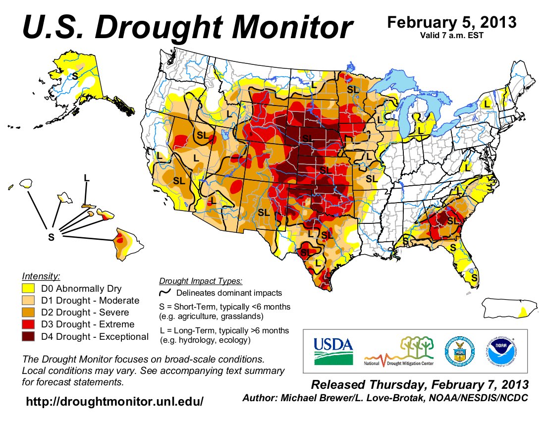
The U.S. Drought Monitor currently shows the whole state under dry conditions with the eastern plains under extreme or exceptional drought conditions, Finnessey noted. In all of the San Luis Valley counties except Mineral the drought monitor indicates severe drought but not extreme or exceptional…

Unfortunately, the drought is forecast to persist at least through the spring months, she added, with temperatures above average and precipitation below average. “We are expecting to see the drought persist and continue at least through April.”

A drought task force is monitoring conditions, Finnessey said. Right now the task force is concentrating on agriculture, but if drought conditions persist, task forces will be activated to deal with impacts to tourism, municipalities, fire and other arenas…

Finnessey was involved in reviewing survey results regarding the effect of the 2011 drought year on the agricultural economy in the Rio Grande and Arkansas River basins, which CSU Agriculture and Resource Economics Professor James Pritchett addressed during the 2013 Southern Rocky Mountain Agricultural Conference in Monte Vista last week. Finnessey said 2012 drought impacts are now being sought from area farmers and ranchers to determine the impact of multiple years of drought, and she encouraged San Luis Valley residents to participate in the survey.

To fill out the survey online, which takes 10-15 minutes and is primarily multiple choice, go to: http://tinyurl.com/CSU-drought

Economic losses due to drought conditions were not just evident in lost production, Finnessey said, but also in lost potential revenue related to that production that might have been realized because of higher commodity prices during that same drought period — “potential revenue, what would have been earned under typical growing conditions.”

Those combinations resulted in an estimated $4.7 million economic impact in the Rio Grande Basin due to drought in 2011, according to Finnessey. By comparison, the Arkansas Basin logged $104 million losses due to drought in 2011 and 1,300 jobs lost. That severity relates to the Arkansas Basin’s reliance on dry-land farming, Finnessey explained…

Most of the state was declared either a primary or contiguous drought area last year, Finnessey said, and although those designations expired at the end of the year, they were renewed again this year. She said the eastern plains were hit the hardest, but the Rio Grande Basin received contiguous classification, which means some benefits. Unfortunately what those benefits will be to area producers is unclear because the Farm Bill is still in limbo, Finnessey said…

Not only farmers and ranchers are worried about water conditions this year, Finnessey added. With reservoir storage less on February 1 of this year than last year at this time, municipalities are concerned about being able to provide enough water for their customers this year, Finnessey said. A web site is being set up that will help folks know about water restrictions in their areas, landscaping and agricultural information under drought conditions. It is not live yet but will be located at coloradodrought.com

From the Casper Star-Tribune (Benjamin Starrow):

Widespread drought in 2012 divided Wyoming’s ranchers into two basic categories: those with hay and those without. The distinction has important implications early in 2013, already showing signs of being another dry year. There may be no better insurance policy against a dry summer than hay. It could mean the difference between keeping and selling key breading stock. That, in turn, could mean the difference between a profitable year and a devastating one.

2012 was the driest year in the last 118, resulting in the state’s worst hay crop since 1950, according to the National Agricultural Statistics Service. Wyoming hay production plummeted from 2.4 million tons in 2011 to 1.9 million in 2012, according to the service. Nationally, hay stocks are down 16 percent. Prices have gone the opposite direction. Alfalfa was selling at $215 a ton in November, compared to $145 last year…

Snowpack levels are down, even with last weekend’s snow storm, National Weather Service Meteorologist Chris Jones said Monday. Snowpack on Casper Mountain was around 40 percent of its 30-year-average. In the Snowy Range and southern Wind Rivers, those numbers ranged from 50 to 65 percent, Jones said…

Precipitation levels, critical for the ground moisture needed for healthy rangeland, are also down in many places in Wyoming. While the northwest and northeastern parts of the state have seen consistent precipitation, central and southeastern Wyoming has struggled.

Casper received 1.71 inches of precipitation between October and January. That is 59 percent of the city’s 30-year average. Last year the city saw 4.06 inches of precipitation over the same period, according to weather service data. In 2011, that number stood at 3.21 inches.

Last week, the state engineer’s office announced it was implementing “priority administration” on the North Platte River and its tributaries north of Pathfinder Reservoir and between Pathfinder and Guernsey reservoirs. All water from the designated section of river will be diverted into the reservoirs for storage. It was the first time the state announced priority administration outside of irrigation season since 2005…

Back at his Casper farm, [Robert Keith] said he believes in the resiliency of the state’s ranching industry. Drought is, after all, a part of life here. His own farm should be in good shape. The Casper Alcova Irrigation District stores water in good years and has a seven-year supply, Keith said. Further, the farm invested in a series of irrigation pivots, increasing the efficiency of Keith’s operations. He said he uses three-quarters of his annual allotment most years. Still, he has worries. “I think we could hold on one more year,” Keith said. “If it happens another year, no one will be in business.”

From the Cortez Journal (Kimberly Benedict):

Buoyed by a recent forecast from the Colorado Basin River Forecast Center, the local U.S. Bureau of Reclamation office has released a tentative operating plan for McPhee Reservoir which predicts all water allocations will be met for the 2013 water year. Though the state of the area’s rivers and reservoirs is far from outstanding, present snow levels and predicted instream flows are reason to be hopeful, according to Vern Harrell, a civil engineering technician with the Bureau of Reclamation’s Western Colorado area office.

“It looks fair right now, not really good, but fair,” Harrell said. “It looks like we most likely will meet all our obligations for the users.”

The present water year comes on the heels of four years of drought conditions which have left local reservoirs dangerously low. Currently, McPhee Reservoir stands 100,000 acre feet below it’s reserve elevation in February 2012. The lack of reserve in the reservoir means water users in the area are counting on a solid snowpack and generous runoff to provide operating water for 2013…

The forecast for the reservoir predicts total accumulation of 205,000 acre feet, roughly 70 percent of average inflow volume. Should the reservoir fill at that rate it would reach a maximum content of 272,988 acre feet, 63 percent full. By October, however, the reservoir would already be pulled down to an elevation lower than where it sits currently. Thus, the cycle of hoping for snow and decent inflow rates would begin again…

Though snowpack seems the most obvious key to a decent water year, the timing of the runoff, current soil moisture and summer weather conditions all contribute to the story of water allocations and reservoir demand. The interplay of these factors can support or hurt water supply…

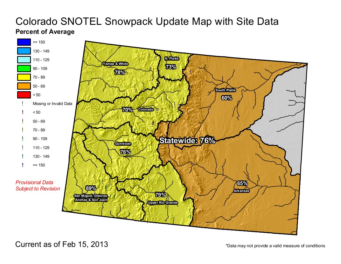
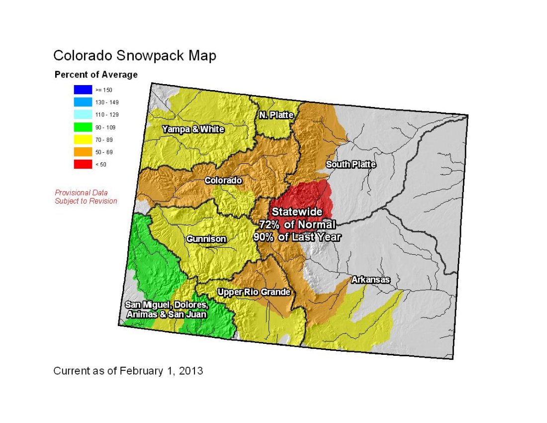
According to automated system data gathered by the U.S. Department of Agriculture’s Natural Resources Conservation Service, the snowpack statewide is at 76 percent of average. Of the eight river basin regions studied by NRCS, the San Miguel, Dolores, Animas and San Juan region is the only basin above 90 percent of average, calculated at 91 percent as of Feb. 12. The Arkansas and South Platte basins are at 65 and 59 percent of average respectively. North Platte stands at 72 percent, Yampa and White at 76 percent, Colorado at 70 percent, Gunnison at 78 percent and the Upper Rio Grande at 81 percent.

From The Mountain Mail (James Redmond):

Typically this time of year the mountains receive an inch of moisture a week, yet weekly totals through Jan. 23 mostly ranged from 0.1 to 1 inch along the Western Slope, with a few isolated pockets receiving 1 to 2 inches, the Water Availability Task Force’s January drought update reported…

In Salida January yielded only 0.01 inch of precipitation throughout the entire month. January usually has an average precipitation of 0.33 inch, historical Mountain Mail records show…

If the Chaffee County area has a drought this year similar to last year’s conditions, “that would be a record,” Terry Scanga, Upper Arkansas Water Conservancy District manager, said Jan. 31.

This area has never seen two back-to-back drought years of last year’s severity, he said. If the drought continues, irrigation rights will see the impact first, probably near July…

“My forecast for late winter, January to March, shows below-normal odds for moisture in much of (Colorado), still consistent with a cold North Pacific (PDO) in conjunction with a warm North Atlantic (AMO),” [Klaus] Wolter reported Positive AMO and negative PDO values go a long way toward explaining our dry fall and early winter. Given the continuing PDO-AMO setup for drought, pessimism remains justified for at least the next few months, he reported.

From The Pueblo Chieftain (Chris Woodka):

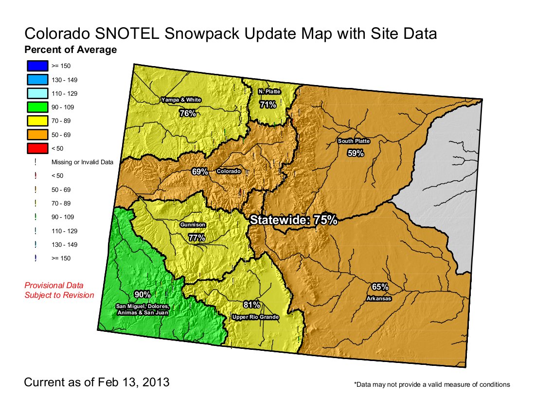
Statewide, snowpack moisture content was listed at 75 percent of average following storm systems that moved through over the weekend. The southwest corner of the state was at 90 percent of average; the Rio Grande basin, 81 percent; and the Arkansas River basin, 65 percent.

About 6 inches of snow were recorded in the Spanish Peaks area, with a moisture content of about 0.35 inches. The largest amounts of water added to the snowpack in the Arkansas River basin came at South Colony in Custer County, Whiskey Creek in Las Animas County and Hayden Pass in Saguache County.

Relatively lower amounts were recorded in the Upper Arkansas River.

“There was about 2 feet of snow in my front yard, but we need about 4 feet this time of year,” said Rego Omerigic of Leadville.

The Willow Creek Restoration Committee is celebrating their 15 year anniversary

commodorewasterockcreede.jpg

From The Mineral County Miner (Guinevere Nelson):

The Creede Mining District had many waste rock piles, seeps, mine adits and mill tailings when the United States Environmental Protection Agency (USEPA) and the Colorado Department of Health and Environment (CDPHE) performed their preliminary assessment of Willow Creek in 1994. The findings prompted further inspection of Willow Creek’s water and were summarized into a report in 1997.

This report provided the basis for listing the Creede Mining District on the National Priorities List under the federal Comprehensive Environmental Response, Com-pensation and Liability Act (CERCLA), commonly known as the Superfund Act.

The Superfund Listing encompassed the entire Creede Mining District, including both branches of Willow Creek. The consequences of Superfund designation on Creede’s tourist based economy were unknown, but a few concerned citizens were not interested in finding out.

Steve Russell from the USDA Natural Resources Conservation Service (NRCS) and Mark Haugen of the Rio Grande Soil Conservation Service and with the support of the City of Creede, held a meeting and informed attendees about the proposed listing.

A year later, the Willow Creek Reclamation Committee was taking action to address the issues causing poor water quality in Willow Creek without EPA intervention. The Creede Mining District was not listed as a Superfund Site and the Willow Creek Reclamation Committee went to work.

To complete their work, the WCRC defined six core goals to guide their efforts: 1) Protect the Rio Grande from future fish kills associated with nonpoint source releases during unusual hydrologic events. 2) Improve the visual and aesthetic aspects of the Willow Creek watershed and its historical mining district. 3) Implement appropriate and cost-effective flood control and stabilization measures for nonpoint sources. 4) Protect and preserve historic structures. 5) Reclaim the Willow Creek floodplain below Creede to improve the physical, chemical, biological and aesthetic qualities of the creek as an integral part of the local community. 6) Continue to improve water quality and physical habitat quality in the Willow Creek watershed as part of a long-term watershed management program.

From its inception, the Willow Creek Project has had a firm commitment to find innovative, non-regulatory approaches to improve the water quality in Willow Creek and to protect the gold medal fishery in the Rio Grande River downstream – a premier fly-fishing stream. Local residents were ready and eager to apply best management practices (BMP’s) to reduce the metals in the stream so that water quality standards could be achieved, only to find out that the information and data on the sources and loadings of the metals were incomplete. The WCRC received CDPHE funding and spent from 1999-2003 sampling surface water, groundwater, waste rock piles, mine pools, macroinvertebrates and fish to fill in the information gaps.

More restoration/reclamation coverage here.

H.R. 267: Hydropower Regulatory Efficiency Act of 2013 passes the U.S. House unanimously

peltonwheel.jpg

From The Telluride Daily Planet (Colin McRann):

The bill is called the Hydropower Regulatory Efficiency Act. With its unanimous passage in the House of Representatives on Wednesday, small hydro projects are one step closer to shedding some federal regulations. U.S. Rep. Diana DeGette (D-Colo.) and U.S. Rep. Cathy McMorris Rodgers (R-Wash.) reintroduced the bill to the House in January.

One of its major supporters is the Colorado Small Hydro Association. Johnson, who is president of the association, has been pushing for the bill’s passage for years because he says current hydropower regulations are unfit to address small hydro projects. “I hope that the Senate acts with the same enthusiasm that the House acted on,” Johnson said. “[If the bill passes] it will lead to development of new small hydro installations and job creation in rural Colorado.”[…]

If the new bill is passed into law, the regulatory process could be streamlined for certain small hydro projects. The bill, as written, provides periods of public comment and directs the Federal Energy Regulator Commission (FERC) to examine the feasibility of a two-year licensing process for certain low-impact hydropower projects. Some of the low-impact projects could include the conversion of existing non-powered dams into power-generating ones.

Historically, western Colorado has been home to a number of small hydroelectric projects, including the Bridal Veil hydroelectric power station above Telluride, the Ames Power Plant and the Ouray Hydroelectric Power Plant. However, new developments with small hydropower projects have not been common in recent years.

The bill states that a significant amount of new hydroelectric generation could come from maximizing existing infrastructure, particularly non-powered dams. It states that only about 3 percent of the nation’s 80,000 dams currently generate hydropower…

To see the full text of H.R. 267, go to govtrack.us.

More hydroelectric coverage here and here.

2013 Colorado legislation: ‘The number of water-related bills tends to be inversely proportional to the amount of snowpack we have’ — Randy Fischer

dnrpipelineconcepts309.jpg

From The Pueblo Chieftain (Chris Woodka):

A bill that would extend the state engineer’s authority to approve interruptible supply agreements was heard in the state House Agriculture Committee this week. Most of the testimony was against the bill, which would allow the state engineer to approve temporary water transfer agreements between cities and farms for up to 30 years, rather than the current limit of 10 years. Leases of water could occur for only three years within each 10-­year period. Claims of injury could be filed in water court.

Opponents of the bill argue that the time period is too long, and that applications in water court are needed in advance to determine if other water rights are injured. Aurora Water, which has sought leases from the Arkansas River basin, is supporting the legislation, [HB13-1013: Protect Water Right Ownership Rights]. Rep. Jerry Sonnenberg, R-­Sterling, and Rep. Randy Fischer, D­-Fort Collins, are co­sponsors of the bill. Sen. Angela Giron, D-­Pueblo, is listed as the Senate sponsor. No vote was taken on the bill during the committee meeting, in order to allow changes to be made.

Another bill, [SB13-074: Irrigation Water Right Historical Use Acreage], passed the Senate ag committee on a 4-­1 vote last week. The bill attempts to clear up ambiguities in pre­-1937 agricultural water rights by allowing the maximum amount of land irrigated during the first 50 years to be claimed as historical usage. The Colorado Water Congress recently voted to oppose the bill because it does not take into account other deliberations water courts used to determine rights. It could expand the amount of acreage claimed in some cases.

A third bill, [SB13-019: Promote Water Conservation], is sponsored by Sen. Gail Schwartz, D­-Snowmass Village, and seeks to provide more incentives for water conservation by easing the requirements to use the water or lose the right. It has not been heard in committee.

From the Fort Collins Coloradoan (Bobby Magill):

Six weeks into the session, water concerns are emerging among the biggest issues lawmakers are addressing. “The number of water-related bills tends to be inversely proportional to the amount of snowpack we have,” said Rep. Randy Fischer, D-Fort Collins. “A lot of people are concerned about the drought coming up, anticipating we’ll be in another year of severe drought.”

Fischer, who is chairman of the House Agriculture, Livestock and Natural Resources Committee, is sponsoring or co-sponsoring at least seven bills that address water supply, irrigation, water conservation or a combination of those issues. Most have quickly gained traction in the Democrat-controlled Legislature.

A bipartisan bill Fischer is working on with the previous GOP chairman of Fischer’s committee, Rep. Jerry Sonnenberg, R-Sterling, would allow farmers to share their water with cities and towns through temporary water exchanges. The bill, [House Bill 13-1130: Reapprove Interruptible Water Supply Agreements], would allow farmers to share their water with businesses and cities without losing the right to use it later, Fischer said…

Fischer said lawmakers were waiting for the Colorado Oil and Gas Conservation Commission to approve new rules on groundwater testing around oil and gas wells and a new regulation requiring a 500 buffer zone between an oil well and the nearest building. Those rules have now been approved, and oil and gas-related legislation will likely be introduced soon, Fischer said…

Lawmakers are coordinating to write legislation addressing local control of oil and gas permitting and resolving a conflict between that local control and state law that requires oil and gas to be regulated only at the state level, [Fischer] said.

A bill likely to be introduced soon will propose increases in penalties for oil and gas companies that spill their products, he said. Another bill may propose additional studies looking into the affects of oil and gas development on public health…

Fischer said he plans to sponsor a bill that will propose a renewable thermal standard similar to the state’s renewable standards for electricity generation. “There is no incentive for people to use ground-source heat pumps for heating and cooling,” he said.

More legislative news from the Coloradoan:

Bills on the move

Senate Bill 19: Promoting water conservation
Allows farmers to reduce the water they consume without losing their water right. Currently, farmers have to use all the water they’re entitled to, or risk losing the right to some of that water.
Northern Colorado sponsors: Rep. Randy Fischer, D-Fort Collins.
Status: Assigned to Senate Agriculture, Natural Resources and Energy Committee.

Senate Bill 41: Preserves water supplies for drought
Reverses a Colorado Supreme Court decision declaring that storing water in reservoirs to prepare for wildfire and drought are not sufficient for water rights owners to keep the right to that water without emptying reservoirs and putting the water to “beneficial use.”
Northern Colorado sponsors: Rep. Randy Fischer, D-Fort Collins, Rep. Jerry Sonnenberg, R-Sterling.
Status: Passed Senate, introduced in House.

Senate Bill 70: Alternative fuels for state fleet vehicles
State fleet vehicles are currently required to be fueled by compressed natural gas. The bill would allow the purchase of other vehicles that run on other cost-effective alternative fuels.
Northern Colorado sponsors: Rep. Randy Fischer, D-Fort Collins; Rep. Dave Young, D-Greeley.
Status: Passed Senate.

Senate Bill 110: Emergency wildfire funds
Creates a wildland fire cost recovery fund in the Colorado Treasury.
Northern Colorado sponsors: Sen. Kevin Lundberg, R-Berthoud; Rep. Joann Ginal, D-Fort Collins; Rep. Dave Young, D-Greeley.
Status: Signed into law.

House Bill 1044: Allowing use of graywater
Allows the state to determine how residential and commercial wastewater that is considered “graywater” can be put to beneficial use as a water conservation measure.
Northern Colorado sponsor: Rep. Randy Fischer, D-Fort Collins.
Status: Passed House Agriculture, Livestock and Natural Resources Committee and referred to House Appropriations Committee.

House Bill 1091: Air quality testing for diesel fleet vehicles
Allows the state to write new rules for air quality testing regarding heavy-duty diesel fleet vehicle owners who can prove excellent maintenance of their fleet.
Northern Colorado sponsors: Sen. John Kefalas, D-Fort Collins; Rep. Dave Young, D-Greeley.
Status: Passed House Transportation Committee and referred to House floor.

House Bill 1130: Water supply agreements between farmers and cities
Allows farmers to share water through temporary exchanges with municipal and industrial water users.
Northern Colorado sponsors: Rep. Randy Fischer, D-Fort Collins and Rep. Jerry Sonnenberg, R-Sterling.
Status: In discussion in House Agriculture, Livestock and Natural Resources Committee.

House Bill 1191: Regulations for wastewater treatment plants
Allows state public health officials to award grants to cities and towns for waste water treatment plant improvements.
Northern Colorado sponsor: Rep. Randy Fischer, D-Fort Collins.
Status: Passed House Agriculture, Livestock and Natural Resources Committee and referred to House Appropriations Committee.

Senate Bill 142: Ceding federal lands
Bill would require the United States government to transfer title to about 23 million acres of national forests and other “agricultural” public lands to the state of Colorado.
Northern Colorado sponsors: Sen. Scott Renfroe, R-Greeley; Sen. Vicki Marble, R-Fort Collins
Status: Passed in Senate State, Veterans and Military Affairs Committee; awaits Senate vote.

House Bill 1122: Energy, jobs and higher education act
Would create “incentive” oil and gas wells, exempting them from severance taxes for two years before severance tax collection resumes and is used for a “college opportunity fund.”
Northern Colorado sponsors: Rep. Jerry Sonnenberg, R-Sterling; Rep. Perry Buck, R-Windsor.
Status: Died in committee

House Bill 1128: Excluding counties from vehicle emissions tests
Would allow county commissioners to exclude all or part of a county from Colorado’s motor vehicle emissions testing program if that part of the county meets ambient air quality standards.
Northern Colorado sponsors: Rep. Brian DelGrosso, R-Loveland; Rep. Perry Buck, R-Windsor; Rep. Steve Humphrey, R-Severance; Sen. Kevin Lundberg, R-Berthoud; Sen. Vicki Marble, R-Fort Collins.
Status: Died in committee

More 2013 Colorado legislation coverage here.

Forecast/snowpack news: Lingering showers over central and eastern mountains #codrought #cowx

From The Mountain Mail (Joe Stone):

Arkansas River basin snowpack ended January at 63 percent of average, second lowest among Colorado river basins. Only the South Platte basin recorded a lower snowpack percentage, 54 percent, according to data compiled by the Natural Resources Conservation Service.

From the Roaring Fork Conservancy:

Current snowpack for the entire Roaring Fork Watesrhed is 70% of average. The snowpack is still lower than both last year and 2002 measurements. The Crystal River sub-watershed is holding the most snow of the entire watershed while the Independence Pass and Nast (in Fryingpan sub-watershed) sites are holding the least.

From the Grand Junction Daily Sentinel (Gary Harmon):

Weekend snows helped, but they hardly heaped up hopes for an improved water outlook in the Colorado River Basin. If anything, the storm underscored just how dry the winter has been. “Seriously, what snowpack?” Colorado River Water Conservation District spokesman Chris Treese said when asked about early indications from weekend snows.

“This is bad. It may not be desperate — yet. We can still creep closer to normal, but it’s going to take a very wet spring, and that’s not the long-term forecast.”

The first look at new snowpack on Grand Mesa feeding Ute Water Conservancy District was marginally more encouraging. Ute’s watershed reached 78 percent of average in the Mesa Lakes area and 
72 percent of average at Park Reservoir, while the overall Colorado River Basin is at 78 percent of average, spokesman Joe Burtard said.

“While this snowstorm has helped our snowpack levels, it is still not enough to ease the concern of domestic water providers in the Grand Valley.

At this point, we will need an above-average snowpack by the time spring hits our mountains” in early April.

Rick Brinkman, water services manager for Grand Junction, said he noted about a foot of new snow atop the mesa over the weekend, but cautioned that little can be concluded for one or two months. The city’s watershed was at 
98 percent of normal snowpack at the beginning of February.

The Drought Response Information Program, a joint effort of water providers in the valley, is still gearing up for water restrictions, said Chairman Dave Reinertsen, also the assistant manager of Clifton Water District.

From the Fort Collins Coloradoan (Bobby Magill):

Meanwhile, the snowpack in the South Platte River Basin, which includes the Poudre River Drainage and all of Larimer County, remains the weakest and driest in Colorado. Water content of the snow in Northern Colorado was 61 percent of median for the season and 66 percent of average for the year, according to U.S. Natural Resources Conservation Service Snotel data for Feb. 14. That’s about 30 percent drier than the region’s snowpack was on the same date in 2012 — one of the driest winters on record that led to the most destructive wildfire season in Colorado history. The water content of the snow for Feb. 14, 2012, was 95 percent of median for the season and 94 percent of average for the year.

Today, the wettest region of the state is southwest Colorado, where the snowpack is about 90 percent of normal and drought conditions are improving.

All of north-central Colorado, including most of Larimer, Jackson and eastern Weld counties, are seeing severe drought conditions, according to U.S. Department of Agriculture Drought Monitor data released Wednesday. The eastern edge of the state remains under extreme and “exceptional” drought conditions.

Flaming Gorge Task Force: ‘I felt we set the groundwork to move forward’ — Reed Dils

dnrpipelineconcepts309.jpg

From The Pueblo Chieftain (Chris Woodka):

Colorado still needs to look at projects to bring in new water supplies despite a state water board’s decision last month to put the Flaming Gorge pipeline task force on ice. The Arkansas Basin Roundtable, the main proponent of the task force, still supports dialogue with other state roundtables on the subject and getting the statewide Interbasin Compact Committee to tackle the issue head­-on.

“It’s time we start looking at issues,” said Jeris Danielson, who represents the roundtable on the IBCC. The IBCC has adopted a “four­legged stool” that includes new supply along with identified projects, conservation and agricultural transfers.

The Colorado Water Conservation Board in January voted to suspend funding for the task force, saying the committee was duplicating work assigned to the IBCC. The group began its work in 2011 to determine issues surrounding two proposals to build water pipelines from southwestern Wyoming to Colorado’s Front Range.

“All of us thought the task force made good progress and had some good discussions on tough issues,” said Alan Hamel, who represents the Arkansas River basin on the CWCB. “Their thoughts will be folded into other work the CWCB is doing to move forward new­supply discussions.”

“I think the most important thing we did was establish a list of attributes for what constitutes a good project,” said Betty Konarski, a member of the task force.

“I felt we set the groundwork to move forward,” said Reed Dils, a task force member and former CWCB representative. “If we’re ever going to see another large project in the state, it will take the cooperation of all the roundtables.”

Roundtable Chairman Gary Barber, who also sat on the task force, said the group identified an immediate gap in agricultural water needs, and a municipal gap by 2020. It made no recommendation on whether or not to build a Flaming Gorge pipeline.

Danielson and Jay Winner, the other basin representative on the IBCC, vowed to press the IBCC to more action at its meeting in March.

More Flaming Gorge Task Force coverage here.

Drought deepens across southeast Colorado #codrought

usdroughtmonitor02122013.jpg

Click on the thumbnail graphic for the current U.S. Drought Monitor map.

From the National Weather Service Pueblo office:

…DROUGHT DEEPENS ACROSS SOUTHEAST COLORADO WITH SOME IMPROVEMENTS IN SOUTHWEST COLORADO…

SYNOPSIS…

JANUARY OF 2013 WAS A RELATIVELY COLD AND DRY MONTH ACROSS THE STATE…SAVE FOR PORTIONS OF SOUTHWESTERN COLORADO…WHICH SAW ABOVE NORMAL PRECIPITATION…THANKS IN PART TO TWO STORM SYSTEMS WHICH BROUGHT ONE TO THREE INCHES OF SNOW WATER EQUIVALENT TO PORTIONS OF THE CONTINENTAL DIVIDE AT THE END OF THE MONTH.

WITH THIS IN MIND…THE CURRENT US DROUGHT MONITOR HAS EXPANDED EXCEPTIONAL DROUGHT (D4) CONDITIONS TO INCLUDE SOUTHERN EL PASO COUNTY…MOST OF PUEBLO COUNTY AS WELL AS EXTREME EASTERN HUERFANO COUNTY. THE CURRENT DROUGHT MONITOR ALSO INDICATES SOME IMPROVEMENT IN THE DROUGHT ACROSS PORTIONS OF SOUTHWESTERN COLORADO…WITH MODERATE DROUGHT (D1) CONDITIONS NOW BEING DEPICTED ACROSS SOUTHERN AND CENTRAL PORTIONS OF MINERAL COUNTY.

EXCEPTIONAL DROUGHT (D4) CONDITIONS CONTINUE TO BE DEPICTED ACROSS CROWLEY COUNTY…OTERO COUNTY…KIOWA COUNTY…MOST OF BENT AND PROWERS COUNTIES…AS WELL AS CENTRAL AND NORTHEASTERN PORTIONS OF LAS ANIMAS COUNTY.

EXTREME DROUGHT (D3) CONDITIONS REMAIN ACROSS EXTREME NORTHERN LAKE COUNTY…EXTREME SOUTHEASTERN CHAFFEE COUNTY…EXTREME NORTHWESTERN SAGUACHE COUNTY AS WELL AS FREMONT COUNTY…SOUTHWESTERN THROUGH EAST CENTRAL TELLER COUNTY…MOST OF THE REST OF EL PASO COUNTY AND SOUTHWESTERN PUEBLO COUNTY. EXTREME DROUGHT (D3) CONDITIONS ARE ALSO INDICATED ACROSS CUSTER COUNTY…THE REST OF HUERFANO COUNTY…MOST OF THE REST OF LAS ANIMAS COUNTY…EXTREME NORTHEASTERN COSTILLA COUNTY…EXTREME SOUTHEASTERN BENT COUNTY…EXTREME SOUTHERN PROWERS COUNTY…AND NORTHERN AND EASTERN PORTIONS OF BACA COUNTY.

SEVERE DROUGHT (2) CONDITIONS CONTINUE TO BE INDICATED ACROSS THE REST OF LAKE…CHAFFEE AND SAGUACHE COUNTIES…NORTHERN MINERAL COUNTY…RIO GRANDE COUNTY…CONEJOS COUNTY…ALAMOSA COUNTY…THE REST OF COSTILLA COUNTY…NORTHERN TELLER COUNTY AND EXTREME NORTHWESTERN EL PASO COUNTY…EXTREME SOUTHEASTERN LAS ANIMAS COUNTY AND THE REST OF BACA COUNTY.

MORE INFORMATION ON THE US DROUGHT MONITOR CLASSIFICATION SCHEME CAN BE FOUND AT: WWW.DROUGHTMONITOR.UNL.EDU/CLASSIFY.HTM

SUMMARY OF IMPACTS…

THE PERSISTENT SEVERE TO EXCEPTIONAL DROUGHT CONDITIONS…BROUGHT ON BY VERY WARM…DRY AND WINDY WEATHER EXPERIENCED ACROSS THE REGION OVER THE PAST TWO YEARS…HAS IMPACTED SOUTH CENTRAL AND SOUTHEAST COLORADO IN MANY WAYS. THESE IMPACTS INCLUDE INCREASED WILDFIRE ACTIVITY AND DANGER…FAILED AND POOR YIELD ON NON IRRIGATED CROPS…CATTLE LOSS AND ABANDONMENT…AS WELL AS QUESTIONS ON WATER AVAILABILITY AND WATER RIGHTS.

THE LATEST COLORADO WATER AVAILABILITY TASK FORCE REPORT INDICATES MANY MUNICIPALITIES AND WATER PROVIDERS ARE CLOSELY WATCHING THE SITUATION AND ARE PREPARING TO RESPOND SHOULD THE DROUGHT CONDITIONS PERSIST OR WORSEN THROUGHOUT THE SPRING AND SUMMER.

FIRE DANGER IMPACTS…

PERSISTENT DROUGHT CONDITIONS…CURED FUELS AND LACK OF SNOW COVER HAS LED TO INCREASED FIRE DANGER ACROSS THE REGION. A CONTINUED LACK OF MOISTURE WILL LIKELY KEEP FIRE DANGER MODERATE TO HIGH ACROSS THE AREA…AND COULD LEAD TO MORE LOCAL GOVERNMENTS INSTITUTING FIRE RESTRICTIONS OVER THE NEXT SEVERAL MONTHS.

THE LATEST INFORMATION ON FIRE BANS AND RESTRICTIONS CAN BE FOUND AT:

WWW.COEMERGENCY.COM/P/FIRE-BANS-DANGER.HTML

AGRICULTURAL IMPACTS…

THE LATEST CPC AND VIC SOIL MOISTURE CALCULATIONS ARE SHOWING SOME IMPROVEMENT IN SOIL MOISTURE CONDITIONS ACROSS SOUTHWESTERN COLORADO AND INTO THE SAN LUIS VALLEY…THOUGH CONTINUE TO INDICATE DRIER TO MUCH DRIER THAN NORMAL CONDITIONS ACROSS MOST OF SOUTH CENTRAL AND SOUTHEAST COLORADO. THE LARGEST DEFICITS IN SOIL MOISTURE REMAIN DEPICTED ACROSS THE LOWER SLOPES OF THE EASTERN MOUNTAINS THROUGH THE SOUTHEAST PLAINS.

CLIMATE SUMMARY…

ALAMOSA HAD A VERY COLD START TO JANUARY…WITH THE AVERAGE TEMPERATURE THROUGH THE 18TH OF THE MONTH COMING IN AT AN AMAZING 18 DEGREES BELOW NORMAL. ALAMOSA WAS FINALLY ABLE TO BREAK STUBBORN INVERSIONS AND WARMED UP THROUGH THE LAST WEEK OF THE MONTH…WITH THE AVERAGE TEMPERATURE FOR THE MONTH AS A WHOLE COMING IN AT 11.7 DEGREES BELOW NORMAL. THIS STILL MAKES JANUARY OF 2013 THE 5TH COLDEST ON RECORD IN ALAMOSA. ALAMOSA RECEIVED 0.07 INCHES OF PRECIPITATION AND 1 INCH OF SNOW THROUGH JANUARY…WHICH IS 0.19 INCHES AND 3 INCHES BELOW THE MONTHLY AVERAGE…RESPECTIVELY.

THE AVERAGE JANUARY TEMPERATURE IN COLORADO SPRINGS WAS 0.2 DEGREES BELOW NORMAL. COLORADO SPRINGS RECEIVED 0.18 INCHES OF PRECIPITATION AND 3.2 INCHES OF SNOW THROUGH JANUARY…WHICH IS IS 0.14 INCHES AND 2.4 INCHES BELOW THE MONTHLY AVERAGE…RESPECTIVELY.

THE AVERAGE JANUARY TEMPERATURE IN PUEBLO WAS 1.1 DEGREES BELOW NORMAL. PUEBLO RECEIVED 0.21 INCHES OF PRECIPITATION AND 3.8 INCHES OF SNOW THROUGH JANUARY…WHICH IS 0.14 INCHES AND 2.7 INCHES BELOW THE MONTHLY AVERAGE…RESPECTIVELY.

Adams State University: The next meeting of the Rio Grande Compact Commission is March 21

alamosarailroaddepot1912.jpg

Click here for the notice. Thanks to Matt Hardesty for sending it along attached to email.

More Rio Grande River Basin coverage here.

Snowpack news: Statewide snowpack = 75% of avg, Upper Colorado = 69% #codrought #coriver

snowpackcolorado02132013.jpg

From The Denver Post (Joey Bunch):

Colorado’s snowpack continues to improve with recent storms. Statewide the snowpack was 75 percent, and as high as 90 percent in southwest Colorado and 76 percent in northwest Colorado. The Colorado River basin was at 69 percent of average Wednesday, according to the Natural Resources Conservation Service in Lakewood.
Snowpack percentages bottomed out in the 40s for some river basins in December.

Forecast news: Snow likely for Denver area (60% chance — NWS Boulder) #codrought #cowx

From The Denver Post (Joey Bunch):

The city has a 50 percent chance of snow Thursday and 40 percent Thursday night, but forecasters expect less than an inch during the day and perhaps a half an inch after nightfall, according to the National Weather Service…

Snow is expected to continue over Colorado’s northern mountains through at least Friday, with from 6 to 12 inches at some locations. Widespread snow is expected to return Sunday night, with a couple more rounds Monday and next Wednesday, according to the N ational Weather Service in Grand Junction.

Food-water study to explain how much water is consumed by cities through food consumption

longspeak.jpg

From The Greeley Tribune (Eric Brown):

Colorado’s top agriculture official and others expressed support Wednesday for a study that explains how much water is consumed by cities through food consumption. Colorado Agriculture Commissioner John Salazar and representatives of the Colorado Farm Bureau and other groups said during a Colorado Ag Water Alliance meeting that those numbers would help educate urban populations on the importance of the state’s ag industry. They said increasing awareness and improving communication between agriculture and metro areas is critical to finding ways to prevent more of Colorado’s irrigated farms from drying up.

State numbers show municipalities and non­ag industries use only about 7 percent of Colorado’s water.
However, Chris Kraft, a Morgan County dairyman who serves as a director for the Western Dairy Association, said those numbers don’t factor in the food eaten by municipal residents. The water used to grow that food for urbanites, Kraft pointed out, is attributed to the agriculture industry, which, according to the state, uses about 85 percent of Colorado’s water. Kraft and others expressed frustration that agriculture often takes heat for using so much more water than municipalities, even though water use in ag later benefits urban populations. To explain the dependency Colorado’s cities have on local farms, Kraft referred to statistics that show 98 percent of all milk consumed in the state is produced only about 50 miles away from the consumer.

In addition to talks of the potential food-­water study, the day also featured discussions how cities and the ag industry can lease and share water with one another in the future to maximize use of the resource. Some attendees agreed that agriculture can find ways to use water more efficiently, but also said urban areas share the responsibility in keeping needed water on farms.

For years, Front Range cities have bought agricultural water to keep up with growth. Buying ag water is less expensive and easier than building new water projects.

In the past, when farming wasn’t profitable, selling water rights to cities gave farmers needed income. But now, water experts worry that too much agricultural water could be bought up by cities, and food production eventually might not keep up with population growth. Instead of buying agricultural water to meet their needs, growing cities should grow more responsibly, Salazar said.

Salazar and John Stulp, Gov. John Hickenlooper’s policy adviser on water, said during the meeting that if cities grow vertically instead of expanding outward, water savings can amount to as much as 50 to 75 percent. Having a study that shows how much ag water returns to cities in the form of food might convince urbanites to take such growth measures.

Before the meeting’s end, Stulp gave tips to Colorado Ag Water Alliance members on ways of acquiring funds for the study.

Green Mountain Reservoir operations update: 130 cfs in the Blue River below the dam #coriver

greenmountainreservoir.jpg

From email from Reclamation (Kara Lamb):

Today, February 13, we are decreasing the amount of water being released from Green Mountain Dam to the Lower Blue River. We are dropping from 170 cfs to about 130 cfs over two changes. The first reduction was at 3 p.m., dropping the flows in the Lower Blue from 170 to 150 cfs. The second change will be at 5 p.m., dropping the release from 150 to 130 cfs. The reason for the change is to balance releases from the dam with inflow to the reservoir. Inflows to Green Mountain dropped today when Denver Water decreased the release to the Blue River from Dillon Dam. The 130 cfs release and flow in the Lower Blue will continue for a while. I will let you know when there are more changes.

More Blue River Watershed coverage here.

Colorado Springs: NOAA to receive 2013 Space Achievement Award April 8

aqariussatelliteartistconceptionjplaugust2011.jpg

Here’s the release from the Space Foundation:

The Space Foundation will present its 2013 Space Achievement Award to the National Oceanic and Atmospheric Administration (NOAA) for its use of space-based systems in making life-saving predictions and issuing early warnings of calamitous weather conditions.

“While most people recognize the value of weather predictions, many don’t realize how NOAA and the National Weather Service use space assets to determine the severity and risks of approaching weather events,” said Space Foundation Chief Executive Officer Elliot Pulham. “The 2013 Space Achievement Award recognizes NOAA and the National Weather Service for valuable space-assisted forecasts and warnings that saved lives and allowed the protection of property throughout the year, particularly with activities in advance of Hurricane Sandy on the east coast of the United States.”

The award will be presented during the opening ceremony of the 29th National Space Symposium on April 8 at The Broadmoor Hotel in Colorado Springs, Colo.

About NOAA
In 2011, the United States experienced 14 weather disasters costing $1 billion or more, more than occurred in any other year on record. Weather affects the decisions made by individuals, companies and governments on a regular basis. Accurate forecasting can help individuals save time and companies save money, and severe weather warnings save lives. The quality of U.S. weather forecasting relies heavily on satellites.

NOAA uses two types of weather satellites: geosynchronous and polar orbiting, historically referred to as the Polar-orbiting Operational Environmental Satellite (POES) and Geostationary Operational Environmental Satellite (GOES) systems.

Using space assets to predict major storms has dramatically reduced deaths from hurricanes, tornadoes and major storms at sea. For example, the Galveston, Texas, hurricane of 1900 killed more than 12,000 people, while early warning and evacuations kept the death toll from Hurricane Sandy to fewer than 300.

NOAA’s mission is to understand and predict changes in the Earth’s environment, ranging from ocean depths to the surface of the sun, and to conserve and manage coastal and marine resources. NOAA’s origins date to 1807, when the nation’s first scientific agency, the Survey of the Coast, was established. Today, NOAA maintains a presence in every state and has emerged as an international leader on scientific and environmental matters.

Learn more about NOAA by visiting www.noaa.gov.

About the Award
The Space Foundation annually presents the Space Achievement Award to an individual or organization for significant contributions in advancing the exploration, development or utilization of space.

Previous recipients include: the Hubble Space Telescope Repair Mission team; China’s Shenzhou 7 Manned Space Flight Team; the United States Air Force; Bigelow Aerospace; the U.S. Titan Launch Vehicle Team; the Inertial Upper Stage Team; the SpaceShipOne Team; the Ariane 4 Launch Team; the Evolved Expendable Launch Vehicle Teams; the NASA/Industry Galileo Space Probe Team; the men and women of United States Space Command and its component organizations; the Hubble Space Telescope Team; Sea Launch; NASA-Boeing International Space Station Team; Gen. Thomas S. Moorman, Jr., USAF, Ret.; Capt. James A Lovell, Jr., USN, Ret.; the American Astronautical Society; Air University; SpaceX and Télécoms Sans Frontières; and in 2012 Junichiro Kawaguchi, Ph.D., Senior Fellow at Japan Aerospace Exploration Agency (JAXA) .

Space Symposium Registration
Recognized as the premier gathering of the global space community, the Space Symposium is slated for April 8-11 at The Broadmoor Hotel, and features presentations and panels covering all aspects of space.

The Space Symposium is offered in conjunction with a separate Space Foundation event, Cyber 1.3, to be held during the day on April 8, immediately preceding the Space Symposium’s opening ceremony.

Register in advance for both events at http://www.NationalSpaceSymposium.org/register. The secure online registration page includes a live chat tab for customer service questions.

Thanks to The Pueblo Chieftain for the heads up.

Colorado River Basin: Say hello to ‘Change the Course’ #coriver

coloradoriverbasin2012doiviatheaspentimes.jpg

Click here for the pitch about restoring water to the Colorado River, from Change the Course. Here’s a report from Brian Clark Howard writing for National Geographic. Here’s an excerpt:

The Colorado River may have cut the Grand Canyon, but for much of its course the river is no longer so mighty. Most of the time, the Colorado no longer even reaches the sea.

The moisture the Colorado River brings to an arid part of the United States and a piece of northern Mexico has sustained generations of people and many generations of wildlife. But that water has long been over allocated, sucked dry by the 30 million people who rely on it for drinking and irrigation.

Once free, the Colorado now has many dams along its 1,450 miles (2,333 kilometers). Its life-giving water is divided up among seven U.S. states and Mexico according to a series of treaties and agreements. But precious little flows remain to support the rich ecosystems that once flourished along the river’s path.

As Wade Davis recently reported, the Colorado once supported a vast, sprawling delta where it met the Gulf of California:

As recently as the last years of the nineteenth century the wetlands produced enough wood to fuel the steamships and paddle wheelers that supplied all of the army outposts, mining camps, and ragtag settlements of the lower Colorado. Today the gallery forests of cottonwood and willow are a shadow of memory, displaced by thickets of tamarisk and arrowweed, invasive species capable of surviving in soils poisoned by salt.

Davis added that, as a result of the loss of rich sediments that were formerly deposited into the Gulf, “Marine productivity has fallen by as much as 95 percent, and all that remains to recall the bounty of the estuary are the countless millions of shells that form the islands and beaches on the shore.”

More Colorado River Basin coverage here and here.

Forecast news: 20% chance of snowfall over the northern mountains over the next few days #codrought #cowx

From The Denver Post:

Colorado’s northern mountains could pick up another 10 inches of snow from Wednesday night to Friday morning, the National Weather Service in Grand Junction says. The snow is courtesy of a series of upper-level atmospheric disturbances, said the forecasters who issued a winter weather advisory from 6 p.m. Wednesday to 6 a.m. Friday for the region northeast of Rifle to the Wyoming line, including Steamboat Springs. Other parts of western Colorado also have snow in the forecast. Aspen has a 20 percent chance of snow Wednesday, 50 percent Wednesday night, 60 percent and 40 percent Thursday night. About an inch is expected Wednesday and up to 2 inches Thursday. Telluride has a 20 percent chance of snow Wednesday night through Friday morning.

Snowpack news: San Miguel, Dolores, Animas & San Juan snowpack = 91% of avg (best in state) #codrought

snowpackcolorado02122013.jpg

southplattebasinhilow02122013.jpg

It’s nice to see a basin in Colorado showing up green on the statewide snowpack map. Let’s hope that the snowpack continues to climb. Click on the thumbnail graphics for yesterday’s statewide snowpack map along with the snowpack chart for the South Platte River Basin. The South Platte headwaters are very dry and the basin is tracking along the 2002 line.

Rio Grande River Basin: Dam repairs set for Beaver Creek Reservoir

beavercreekreservoir.jpg

Here’s the release from Colorado Parks and Wildlife:

Colorado Parks and Wildlife will start a two-year construction project this summer to repair the dam at Beaver Creek Reservoir. If work proceeds as planned, the 4,400-acre-foot reservoir will be filled again by summer of 2015.

Problems with the 100-year-old dam structure were discovered in 2010. Since then the reservoir has been drawn down to about half of its capacity. The reservoir, located about 5 miles south of South Fork in the San Luis Valley, is owned by Colorado Parks and Wildlife and the water is used for irrigation, fishing recreation and to maintain wildlife habitat. Because it sits high in the Rio Grande River drainage, the reservoir also plays a major role in overall water management in the San Luis Valley.

“Colorado Parks and Wildlife works closely with other water entities throughout the valley and Beaver Creek Reservoir is an important link in the overall system,” said Rick Basagoitia, area wildlife manager in Monte Vista.

Fishing at the popular reservoir will be allowed to continue through this year. No fish have been stocked at the reservoir since 2011; however, there are still plenty of kokanee, brown trout and rainbow trout in the reservoir. Accessing the water requires walking down the steep-sided slopes of the reservoir, so anglers are urged to be careful.

Early in 2014 the reservoir will be drained completely to accommodate construction activity.
Stocking of fish will resume in 2015. Two U.S. Forest Service campgrounds near the reservoir will also remain open during construction.

In the first phase of the project the spillway will be rebuilt. That work will start in July and should be completed by about December.

Phase two is planned to start in April 2014 and will include building a new abutment support for the dam, improvements to the outlet tunnel and a building to house equipment. That work is planned for completion by early winter 2014.

The estimated cost for the project is about $15 million.

The reservoir is located on National Forest System Lands. If anyone wants to comment on the dam repair plan, comments should be sent to: Tom Malecek, District Ranger, 13308 West Hwy 160, Del Norte, CO 81132; FAX Number: 719-657-6035. The office business hours for those submitting hand-delivered comments are: 8 a.m. to 4:30 p.m., Monday through Friday, excluding holidays. Oral comments can be made via telephone during normal business hours at 719-657-3321 or in person. Electronic comments may be submitted to comments-rocky-mountain-rio-grande-divide@fs.fed.us or online at the project webpage http://www.fs.usda.gov/projects/rio-grande/landmanagement/projects under “Comment on Project”. Comments must be submitted by March 8.

More Rio Grande River Basin coverage here.

The latest Barr Lake Oasis newsletter is hot off the press

barrlakeparksandwildlife.jpg

Click here to read a copy of the newsletter. Check out the dates for the bald eagle viewing.

More South Platte River Basin coverage here.

Weekly Climate, Water and Drought Assessment of the Upper Colorado River Region #codrought #cowx #coriver

wyutcoprecipitation0201thru02092013.jpg

Click on the thumbnail graphic for the precipitation summary for February 1-9, 2013. Click here for all the summaries from the Colorado Climate Center.

Photo of fog-filled Black Canyon of the Gunnison from the Interior Department

fogfilledblackcanyonofthegunnisonnps.jpg

Click on the thumbnail to go to Interior’s Instagram page.

Forecast news: ‘A series of weak Pacific storms…over the next few days’ — NWS Grand Junction #codrought #cowx

Snowpack news: Upper Arkansas, San Juans get needed snowfall #codrought #cowx

seasonaldroughtoutlookcpc02072013.jpg

snowpackmapmajorbasinsfebrurary12013nrcs.jpg

usdroughtmonitor02052013.jpg

Click on the thumbnail graphics for the February 7 seasonal drought outlook from the Climate Prediction Center, along with the February 1 statewide snowpack map by basin from the NRCS and the current US Drought Monitor map. The seasonal drought outlook shows some hopeful news for the Four Corners region.

From The Pueblo Chieftain (Tracy Harmon):

Welcome snow fell in the Upper Arkansas River Valley Monday, bringing 5 inches to Canon City and closing schools in Canon City, Florence and Penrose. Custer County residents reported 4 inches of snow and were bracing for another 8 to 12 inches expected to fall today. Salida residents also reported 4 inches of snow and there were 3 inches of snow in Buena Vista and 2 inches in Maysville. Monarch Mountain reported 1 inch of new snow. Around the San Luis Valley, the snowstorm continued to bury the eastern San Juan Mountains, as Wolf Creek Ski Area reported 23 inches of snow Monday morning from the previous 24 hours.

COGCC Finalizes Nationally pacesetting rules to limit drilling impacts — Todd Hartman

oilrigssharingaplatformfrontrangeschoolofminesalfredeustes.jpg

Here’s the release from the Colorado Oil and Gas Conservation Commission:

The Colorado Oil and Gas Conservation Commission today gave final approval to the strongest rules in the country for limiting the impact of drilling near residences and other occupied buildings. Today’s final approval by a vote of 8 to 1 follows the Commission’s preliminary vote to approve on January 9. The new rules will take effect August 1.

These comprehensive new rules combine stringent protective measures, expanded notice and outreach to local communities and heightened distances (called “setbacks”) between drilling and dwellings to further distinguish Colorado as a pacesetter nationally for model regulation of oil and gas development.

Colorado’s new rules for setbacks and associated measures will strengthen protections for public health, safety, welfare and the environment. The rules also set a new standard for the Rocky Mountain West as they exceed in every aspect requirements in our neighboring states of Kansas, Wyoming, Utah, New Mexico, Nebraska and Arizona.

Earlier this year, the Commission also approved rules that are among the strongest in the country for monitoring and protection of groundwater. Only two other states have mandatory groundwater programs in place and no other state in the country requires operators to take post-drilling water samples.

“I am proud of this Commission for acting in a responsible fashion on a challenging issue that is of high significance to the people of Colorado,” said Department of Natural Resources executive director Mike King. “We have fulfilled our obligation to address the toughest matters and work toward the best interests of the citizens. This Commission has shepherded through a rule that once again makes Colorado an example for other states to follow.”

“We’ve heard from so many Coloradans with important perspectives on a highly charged and complicated issue, as difficult an issue as this Commission has ever addressed,” said Matt Lepore, director of the Colorado Oil and Gas Conservation

Commission. “We’ve tried to reach a balance that fairly considers and applies all theconcerns expressed. We believe it best addresses this tough public policy challenge by protecting the public welfare, respecting a variety of property rights and economic issues and allowing necessary development of our energy resources.”

The new rules include a suite of important new provisions. They include:

  • Operators proposing to drill within 1,000 feet of an occupied structure would be required to meet new and enhanced measures to limit the disruptions a nearby drill site can create. Those measures include closed loop drilling that eliminate pits, liner standards to protect against spills, capture of gases to reduce odors and emissions, as well as strict controls on the nuisance impacts of noise, dust and lighting.
  • Existing setback standards of 150 feet in rural areas and 350 feet in urban areas are extended to a uniform 500 feet statewide.
  • Operators cannot drill within 1,000 feet of buildings housing larger numbers of people, such as schools, nursing homes and hospitals, without a hearing before the Commission.
  • Operators must engage in expanded notice and outreach efforts with nearby residents and conduct additional engagement with local governments about proposed operations. As part of this, operators proposing drilling within 1,000 feet must meet with anyone within that area who asks.
  • Development of the new standards follow a stakeholder process that began a year ago, in February of 2012, with a series of meetings and presentations designed to work through the many complicated elements associated with determining setback criteria. Extensive comment and direction came from local governments, farmers and ranchers, the environmental community, homeowners, the energy industry, elected officials, homebuilders, mineral owners, environmental health specialists and business leaders.Commission staff spent much of last year engaging these stakeholders in order to develop rules that protect the public health and environment while providing the flexibility needed for energy production and the thousands of jobs it creates.

    The Colorado Department of Natural Resources and the Colorado Department of Public Health and Environment have also announced the launch this summer of a significant study of emissions tied to oil and gas development. The project will provide information about how oil and gas emissions behave, how they travel and their characteristics in areas along the northern Front Range. A second phase would assess possible health effects using information collected in the first phase.

    Last year, Colorado developed a national model for the disclosure of chemicals used in hydraulic fracturing fluids, forged stronger, more collaborative relationships between state and local regulators, increased oversight staffing amid challenging budget constraints, opened the Oil and Gas Conservation Commission’s water quality database to public access on the Internet and further strengthened rules to reduce emissions.

    From The Grand Junction Daily Sentinel (Dennis Webb):

    The Colorado Oil and Gas Conservation Commission this morning signed off on sweeping new rules governing minimum setbacks between oil and gas drilling and homes and other buildings.

    The commission voted 8-1 to establish 500-foot minimum setbacks that can be waived under certain circumstances.

    Companies would have to mitigate traffic, noise, fume and other impacts for drilling within 1,000 feet of buildings. A commission hearing would be required of anyone seeking to drill fewer than 1,000 feet from schools, hospitals, nursing homes and other public buildings.

    Companies now can drill as close as 150 feet from homes in rural areas and 350 feet from high-density neighborhoods.

    The commission passed the measure amid increasing public concern as drilling nears more urbanized Front Range communities.

    “Although not perfect, it does improve the likelihood that the public is going to be safer than before,” said Commissioner Chris Urbina, also executive director of the state Department of Public Health and Environment.

    Commissioner Tommy Holton, also mayor of Fort Lupton, cast the sole vote against the measure, citing the lack of scientific data over possible health impacts from nearby drilling.

    “We need to base this on fact and not change the rules just because we can,” he said.

    From The Denver Post (Mark Jaffe):

    “Undoubtedly, this decision will go under the dome,” said Mike King, executive director of state Department of Natural Resources and a commission member. King said he was “comfortable” with the rule and that the legislators would see how contentious an issue setbacks are.

    House Majority Leader, Dickey Lee Hullinghorst, D-Boulder, issued a statement saying the rules “fall far short of protecting Coloradans.”

    “As the State legislature continues its work this session, my colleagues and I will be looking to pursue measures that put the health and safety of Coloradans first,” Hullinghorst said.

    Chris Urbina, director of the Colorado Department of Public Health and Environment and a commission member, said the rule “increases the likelihood the public will be safer than before.”[…]

    “The way it stands, homeowners have no certainty a well won’t be drilled close to their houses,” said Matt Sura, an attorney representing Western Slope conservation groups.

    The setback issue isn’t the only one that may be addressed in legislation, said Pete Maysmith, executive director of Conservation Colorado. “Setbacks aren’t the be all and end all, there are other issues around oil and gas drilling that we may see addressed,” Maysmith said.

    More oil and gas coverage here and here.

    Englewood: The next meeting of the Barr Lake/Milton Reservoir Watershed Association is April 24

    barrlake.jpg

    Click here for the agenda. Thanks to Amy Conklin for sending it along in email.

    More South Platte River Basin coverage here.

    Major improvements get underway in Arkansas River below Pueblo Dam

    puebloreservoir.jpg

    Here’s the release from the Colorado Parks and Wildlife:

    Heavy equipment operators will be placing large rocks and boulders in the Arkansas River the next couple of months as part of a habitat improvement project below Pueblo Dam. Work is set to begin Feb. 11.

    “There will be a temporary inconvenience to anglers in the first three miles below the dam during construction, but the long-term impact will improve fishing,” said Doug Krieger, a senior aquatic biologist for Colorado Parks and Wildlife.

    “Anglers may encounter front-end loaders and heavy equipment during the construction portion of the project, but the long-term implications are that there will be more structures that hold fish,” said Krieger.

    The work is part of Phase II of a project that originally began in 2004. Since completion of Phase I in 2005, the Arkansas River through Pueblo has gained a reputation as a premier fishing location.

    The Phase II portion of the project consists of improving fish habitat structures along approximately seven miles of the river from the dam to Dutch Clark Stadium. Sixty percent of the work will be modifications to existing structures that were installed in 2004 and 2005. The remaining 40 percent will be the installation of additional rock and log structures. Approximately 3,000 additional boulders will be added.

    A hiking trail and bike path runs along the entire stretch of river through the city, making it accessible by foot. There are several access points where anglers can park right next to the river.

    Because Pueblo Reservoir creates clear, cool water and stable outflows from November until the middle of March, anglers have an opportunity to enjoy stream fishing during times of the year when most streams are locked in winter conditions.

    The project will significantly increase available fishable water through the city of Pueblo, thereby providing more angling opportunity, less crowding and greater angler satisfaction.

    Partners in the project include the City of Pueblo, The Pueblo Conservancy District, The U.S. Bureau of Reclamation, Trout Unlimited, Xcel Energy, the Packard Foundation, the US Fish and Wildlife Service Sport Fish Restoration Program, and Colorado Parks and Wildlife.

    More Arkansas River Basin coverage here.

    CWCB: Next Water Availability Task Force meeting, February 14 #codrought #cowx

    uncompahgrevalleylookingsouthtowardsneffels.jpg

    From email from the Colorado Water Conservation Board (Ben Wade):

    The next Water Availability Task Force meeting is on Thursday, February 14 from 9:30a-12noon & will be held at the Colorado Parks & Wildlife Headquarters, 6060 Broadway, Denver in the Bighorn Room.

    The agenda will be posted at the CWCB website in the next few days.

    More CWCB coverage here.

    Forecast news: Winter storm winding down across Colorado #codrought #cowx

    Snowpack/drought news: San Miguel, Animas, Dolores, San Juan slightly ahead of last year #codrought #cowx

    snowpackcolorado02072013.jpg

    usdroughtmonitor02052013.jpg

    Click on the thumbnail graphics for the current statewide snowpack map and the latest U.S. Drought Monitor Map. The storms over the weekend are not reflected in the snowpack map. There may be an update today from the Natural Resources Conservation Service. Individually, the San Juan and Dolores watersheds were showing average snowpack yesterday.

    From The Telluride Daily Planet (Collin McRann):

    As of Feb. 1, the snowpack in the San Juan/Animas/Dolores and San Miguel basins of southwestern Colorado was around 88 percent of normal. While snow levels might not be drastically far from average, state hydrologists say a significant amount of new snow would be needed to end the ongoing drought. The next two months will be crucial in terms of snowfall because a full third of yearly snowfall in Colorado typically falls between January and March.

    “We really just have February and March left — during those months we receive around 20 percent of the snowpack, and so to recover in that amount of time could be difficult,” said Mage Hultstrand, assistant snow supervisor with the Colorado Snow Survey. “The snow we received [in late January] is really good, but we still have a ways to go to reach average conditions. After last year’s below average [snowpack], the storage in our reservoirs has dropped significantly. So this is kind of a vital year in terms of replenishing those.”

    This year’s snowpack is slightly higher than it was in early February last year, according to data from the Natural Resources Conservation Service. Both this year and last year’s snowpack are far below the previous two years, which saw above average snowfall…

    Last year, a month-long string of storms gave the snowpack a boost in February, but the skies dried up in March and snowpack hit a plateau. Warm, dry temperatures that followed in the spring led to rapid melting, and by June 1 the snowpack was completely gone. Snowpack in the mountains typically hangs on until July.

    Data from the U.S. Drought Monitor shows that all of San Miguel County is classified as experiencing severe drought — which has been unchanged since last summer.

    Snowfall data shows there was little or no snowpack in the region until mid-November, and the next major storm did not blow in until mid-December. However, since then the snowpack has grown steadily.

    From The Colorado Springs Gazette (Ryan Maye Handy):

    At Monday’s informal Colorado Springs City Council meeting, Utilities will propose a plan to help the city grapple with the persistent drought that, it believes, will continue to plague Colorado into the summer months. Utilities will present water restriction guidelines to council, along with an overview of the drought and water situation in El Paso County and suggestions on how to get residents to cut down on water use. If the plans are eventually adopted by the council, the water restrictions should go into effect on April 1. Utilities officials are seeking approval in early March.

    “We have been here before,” said Utilities spokeswoman Patrice Lehermeier on Friday. “It was not as drastic as we are now seeing.”

    The phenomenal amount of snowfall and precipitation in 2011 carried Colorado through 2012 without water restrictions being imposed in El Paso County, said Lehermeier. But, the reserve moisture and water that allowed Colorado Springs homeowners to water their lawns regularly last summeris no longer there. Instead, the city has started 2013 in greater need of precipitation.

    To balance the unusually high amount of water used in Colorado Springs last summer — and to create a decent reserve of water for public safety concerns, such as firefighting — Utilities has come up with two main alternatives for homeowners. Starting on April 1, pending council approval, restrictions may include two day or three day per week watering restrictions, or a drought surcharge for those whose water use surpasses the restrictions.

    Last summer, the city consumed the highest amount of water — 28.7 billion gallons — since 2001, Utilities statistics show. In 2012, the average annual temperature was the highest it had been since 1895…

    Colorado is among a handful of Western states that could be hard-hit by the dwindling water supply this year, according to January stream flow forecasts from the Natural Resource Conservation Service. January got off to slow start, precipitation-wise, and snowpack levels are the fourth lowest they have been in 32 years, according to the report updated monthly.

    From The Mountain Mail (Joe Stone):

    Arkansas River basin snowpack ended January at 63 percent of average, second lowest among Colorado river basins. Only the South Platte basin recorded a lower snowpack percentage, 54 percent, according to data compiled by the Natural Resources Conservation Service.

    From the Leadville Herald-Democrat (Marcia Martinek):

    Some unusual weather in January was noted by Charles Kuster, the Herald’s weather guru, starting with a string of low daily minimum temperatures. Between Dec. 28, 2012, and Jan. 22, 2013, there were 26 days in a row when the low daily minimum temperatures were below zero, Kuster said. This was the second-longest stretch in his 29 years here charting weather statistics. The longest was between Jan. 10 and Feb. 7, 2008, when there was a 29-day stretch. The winter of 2007-2008 had 82 days when the temperature was zero or lower; the average here is about 60 days.

    For seven days in a row, Dec. 28, 2012, to Jan. 3, the minimum lows were -10 degrees Fahrenheit or lower, setting a record, according to Kuster. The lowest temperature experienced here in an average year is -22 to -26 below zero although this is actually around -20 for those who live within Leadville city limits, Kuster said. He lives in Lake County.

    Snow measured 8.9 inches in January, Kuster said. The average snowfall for January is 17 inches, so we’re at about 50 percent of normal. “When a year starts with an El Niño, there’s never normal snowfall,” Kuster said. His unofficial prediction is for below normal precipitation in February, March and April.

    “I’m hoping I’m wrong,” he said.

    The Greeley Tribune editorial staff comes out in favor of NISP

    nisppreferredalternative.jpg

    From The Greeley Tribune via the Northern Colorado Water Conservancy District (Brian Werner):

    We agree with Colorado Commissioner of Agriculture John Salazar when he said last week that a combination of conservation and new water storage are needed to solve an impending catastrophe for farmers and
    ranchers.

    Salazar was referring to a projected 600,000 acre-foot water shortage that is expected to hit Colorado by the
    year 2050.

    Speaking at last week’s Colorado Farm Show, Salazar said municipal users, including those of us who apply a
    vast amount of water to our Kentucky bluegrass, must get smarter about water consumption. He also said
    farmers and ranchers must take better advantage of technology to do a better job of conserving water. And he
    said, too, that water-storage projects (can you say Northern Integrated Supply Project?) must be part of the
    state’s 50-year water plan.

    We agree on all three accounts.

    Salazar’s message hits home with extra impact this winter. Statewide snowpack is sitting at 67 percent of
    average, and many of the state’s reservoirs already range from near empty to two-thirds full. Unless the final
    three months of the winter provide bountiful snow, Colorado could very well be facing the reality of a water
    shortage starting this summer.

    Salazar pointed out that Coloradans consume about 120 gallons of water every day. Australians, by
    comparison, use 36 gallons per day. That stark difference points out that more can, and must, be done to
    conserve the water we use on an everyday basis. Those who grow crops certainly must be participants in that,
    and we know from previous coverage that some Weld County farmers already are converting to drip irrigation
    systems, which save a considerable amount of water compared to the conventional flood irrigation. Residential
    water users must do a better job of embracing xeriscaping and reducing other household water consumption,
    and we know that Greeley has been among the state’s leaders in securing significant water savings over the
    past few years.

    But we must do more.

    And that includes building more water storage. The NISP project in northern Colorado is one of the most
    responsible, common-sense water storage projects this state has seen in decades. It has to win the approval
    of federal regulatory agencies, but we would expect that to happen within a few years and hopefully
    construction can start soon thereafter.

    Salazar said “massive cooperation” must occur for the state to meet its future water needs. We would agree,
    and if we don’t, we’re likely to encounter a massive water problem.

    More Northern Integrated Supply Project coverage here and here.

    The January Colorado River District board meeting summary is hot off the press #coriver

    coloradoriverbasincgs.jpg

    Click here to read the summary. Thanks to Jim Pokrandt for sending it along in email.

    More Colorado River Basin coverage here and here.

    ‘Drought years back to back, that’s when you start having problems across the state’ — Wendy Ryan #codrought #cowx

    usdroughtmonitor02052013.jpg

    snowpackcolorado02072013.jpg

    From the Summit Daily News (Jessica Smith):

    The statewide snowpack is at 72 percent of the average for this time of year and 90 percent from last year. For Summit County, in the Colorado basin, snowpack is only at 67 percent of the average for February and 89 percent of where it was last year. This means that the Colorado basin currently has just over half of the amount of snow it should have and just over 10 percent less than it had at the same time last year.

    Colorado is not seeing the snowstorms it needs to alleviate the powder deficit. The entire state has been experiencing high-level drought conditions, according to the U.S. Drought Monitor website. Exceptional Drought (D4) has crept across the Eastern Plains, while Summit County is engulfed in red at the Extreme Drought (D3) level.

    “When we start stringing drought years back to back, that’s when you start having problems across the state,” said Wendy Ryan, research associate at the Colorado Climate Center at Colorado State University. “The odds are definitely stacked in favor of having a below-normal snowpack year again.”

    The pattern of snowfall has been acting differently this year, Ryan said. In the past, snowfall has been continual, with small amounts falling in between big storms. Recently, however, periods of dryness and no snow have come sandwiched between the larger snowstorms.

    “That’s really what sets us back. We should be accumulating about an inch of water a week in the mountains,” said Ryan, but that hasn’t been happening.

    From the Sky-Hi Daily News:

    Snowpack in the high-elevation mountains above Middle Park are now around 73 percent of the 30-year average. Last year’s snowpack at this time was similar at 75 percent of average.

    Snow density is low, however, averaging at only 19 percent, which means that for a foot of snow there are 2.3 inches of water, according to the USDA Natural Resources Conservation Service Kremmling Field Office, from which Mark Volt and Noah Bates conducted snow surveys in the last days of January…

    Reported readings for the major river basins in Colorado are as follows: The upper Colorado River Basin averages 68 percent; Gunnison River Basin, 77 percent; South Platte River Basin, 61 percent; Yampa and White River Basins, 79 percent; Arkansas River Basin, 64 percent; Upper Rio Grande Basin, 77 percent; San Miguel, Dolores, Animas, and San Juan River Basins 85 percent; and the Laramie and North Platte River Basins,73 percent of average for this time of year.

    Water meters may be on the horizon for Ouray

    ouray.jpg

    From the Watch (Samantha Wright):

    Council unanimously approved a resolution supporting a $35,000 water efficiency grant application to the Colorado Water Conservation Board to help pay for the development and implementation of a Water Efficiency Plan. The plan was mandated by the Colorado Division of Water Resources last summer, when Ouray’s water supply was called by downstream senior water users.

    The ultimate purpose of the Water Efficiency Plan, according to the grant application authored by the city’s water consultant Wright Water Engineers, is to develop a program to better meter water usage and reduce future water demand through multiple steps including leak detection and repair programs; landscape irrigation programs; educational programs on water use; plumbing fixture ordinances and programs and a commitment to track and report progress and make adjustments as needed.

    A recent study conducted by Wright Water Engineers showed that residential use accounts for 71 percent of Ouray’s water demand, and that residents use more water than the national average. In implementing the Water Efficiency Plan, the goal is to lower per capita water demands by at least 10 percent over the next decade.

    More infrastructure coverage here.

    A Brief History of the South Platte River Basin

    Here’s a great use of social media to get the word out about HB12-1278. The YouTube video — produced and directed by Colorado Water Institute, animated by Noah Besser — follows the history of the appropriation and administration of the South Platte River downstream of the mountains.

    Good luck implenting HB12-1278 Reagan and team.

    Thanks to Coyote Gulch reader Greg from Nebraska for the link.

    More South Platte River Basin coverage here and here.

    HB13-013 passes out of the House Agriculture, Livestock and Natural Resources Committee #coleg

    powderhornskiarea.jpg

    From the Sterling Journal-Advocate (Marianne Goodland):

    [HB13-1013: Protect Water Right Ownership Rights], which is sponsored by Rep. Jerry Sonnenberg (R-Sterling), passed the committee unanimously, but not without a little last-minute wrangling during the Feb. 4 hearing. Rep. Mike McLachlan (D-Durango) announced during the hearing he intended to amend the bill to limit the impact to ski areas because he said the bill was too broad.

    The issue was brought to the Legislature by the ski industry, but during a Jan. 28 hearing, attorney Glenn Porzak told the committee that the Forest Service had issued similar directives on water rights for ranchers and other agricultural users who lease federal lands for grazing.

    McLachlan eventually decided not to add the amendment and HB 1013 is now awaiting action from the House Appropriations Committee. A companion measure, House Joint Resolution 13-1004, passed the full House on Feb. 1 and is headed to the Senate. Sonnenberg also won House support this week for HB 1034, which would allow commodities warehouses and elevators to issue electronic receipts that could be shared with banks and other financial institutions. HB 1034 passed the House 64-0 on Feb. 4, and is now in the Senate.

    More 2013 Colorado legislation coverage here.