Las Vegas’ water supply comes primarily from stored Colorado River water in Lake Mead. With all the demand on the river nowadays the metroplex is looking to mine groundwater north and east of the Las Vegas Valley to shore up supplies. They lost a round in court last week. Here’s a report from Hannah Holm writing for the Glenwood Springs Post Independent. Here’s an excerpt:
In September, SNWA senior deputy general manager John Entsminger told the crowd at the Colorado River District’s annual seminar that the long-term plan was to prepare for reduced availability of Colorado River water in part by developing new sources of water from outside the river basin. A centerpiece of this plan was to develop a pipeline to bring 84,000-acre-feet per year of groundwater from the Spring, Cave, Delamar and Dry Lake valleys in Northern Nevada down to the Las Vegas metro area. These valleys lie within the Great Basin, which swallows its runoff underground and evaporates it from vast salt pans rather than sending it towards the Pacific via rivers.
The Nevada State Engineer granted the SNWA rights to the groundwater in the northern valleys in 2012, but on Dec. 12, the Salt Lake Tribune reported that a Nevada state judge had invalidated the state engineer’s decision to grant the rights. The ruling claimed that in deciding to grant the rights, the state engineer failed to adequately investigate the potential impact to existing water rights and the environment. Lawyers for the ranchers and environmentalists in the “donor” valleys who had fought the pipeline project, as well as residents Utah’s neighboring Snake Valley, cheered the ruling.
I doubt that we’ve heard the end of the story on this controversy, and it bears watching. Despite the fact that Las Vegas exerts a relatively small demand on the Colorado River, its predicament could still have repercussions here in Colorado. A number of analysts have noted that no matter what the “law of the river” says, it is unlikely that a city of 2 million people will have its tap turned off. Keeping the tap on could require increased releases from Lake Powell, with domino effects upstream for water use in Colorado. Also, the way competing demands for water between urban users, agriculture and the environment are dealt with in Nevada could foreshadow how similar tensions are dealt with here.
Upper Colorado River Basin High/Low Graph December 19, 2013 via NRCS
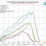
South Platte River Basin High/Low graph December 19, 2013 via NRCS
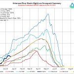
Arkansas River Basin High/Low graph December 19, 2013 via NRCS
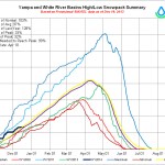
Yampa/White Basin High/Low graph December 19, 2013 via NRCS
Gunnison Basin High/Low graph December 19, 2013 via NRCS
San Miguel/Dolores/Animas/San Juan Basin High Low graph December 19, 2013 via NRCS
Upper Rio Grande Basin High/Low graph December 19, 2013 via NRCS
Laramie/North Platte Basin High/Low graph December 19, 2013 via NRCS
Mage at the NRCS has been busy this week updating snowpack graphics. Click on the thumbnail graphics to scope out your favorite areas for winter fun. Click here to go to their FTP site for more informative graphics.
The region’s snowpack, critical for meeting water demands each year, will enter 2014 in much better shape than it did the past two years.
On Thursday, the South Platte Basin’s snowpack was right at normal — 100 percent of historic average, according to the Natural Resources Conservation Service’s SNOTEL data system.
Snowpack for the basin sat at only 70 percent of average at the start of this year, leaving many water providers and users concerned about supplies for the upcoming year — although late spring storms increased snowpack up to 153 percent of average by the end of May, helping the situation. At the start of 2012, South Platte snowpack was 85 percent of average — then drought set in, and snowpack plummeted to only 2 percent of average by the end of spring.
Typically, heavy snowstorms in March and April play the biggest role in determining water supplies each year, eventually providing runoff that fills reservoirs and irrigation ditches.
Still, the good early snowpack start has many water providers and users more optimistic than they were the past two years. In addition to normal snowpack, heavy rains in September that caused flooding also put more water in reservoirs, which was much needed after reservoir water was heavily used to get through the drought of 2012 and water levels dwindled.
Many — particularly the agriculture industry, which uses about 85 percent of the state’s water, according to the Colorado Division of Water Resources — would prefer a repeat of the record-high snowpack levels of 2010 and 2011. But they’ll take the average snowpack they have heading into 2014, after the rollercoaster ride of 2012 and 2013. Even though snowpack rebounded by May 2013, much of that snowmelt was only used to fill reservoirs that had been depleted by 2012’s drought, and some users didn’t get as much water as they had hoped.
Like the South Platte Basin, the Colorado River Basin, from which the northern Front Range also diverts some of its water through trans-mountain tunnels, also is well ahead of where it was during the past two years. The Colorado Basin’s snowpack was 105 percent of average Thursday, after sitting at 68 percent at the start of 2013, and at 63 percent at the start of 2012.
All eight of Colorado’s river basins were above average as of Thursday.
The Gunnison River Basin was in the best shape at 122 percent of average.
The South Platte Basin was the lowest at 100 percent of average.
Colorado’s credit for water deliveries at the Kansas state line stands at more than 58,700 acre-feet under a rolling 10-year average. The annual accounting of deliveries, related to a 24-year U.S. Supreme Court case over the Arkansas River Compact, was given to the compact administration Wednesday.
In 2012, marked by statewide drought, there was a net depletion of 5,500 acre-feet to the Arkansas River. That was combined with other flows since 2003 to calculate the 10-year average.
While the final decision in the court case was issued in 2009, Colorado and Kansas continue to work through issues related to water deliveries.
Bill Tyner, assistant engineer for Colorado Division 2, reported that 1,160 acre-feet of replacement water was made available by the Lower Arkansas Valley Water Conservancy District to compensate for on-farm sprinkler improvements on more than 14,500 acres covering 100 farms.
Tyner reported a pond study is showing about 18 percent seepage, which is nearly twice the assumed rate in a “conservative” computer model. The pond study will be complete next year, but results from individual measurements already are being applied as credits for about 20 individual farmers.
“We’ll report next year on any changes we make in the model,” Tyner said.
Kansas accepted Colorado’s evaluation of the presumptive depletion for well pumping at 36.5 percent next year, said Kelly Thompson of the Colorado Division of Water Resources.
Kansas still has issues with a Colorado water court decree for the Lower Arkansas Water Management Association, said Eve McDonald, of the Colorado attorney general’s office.
For the second consecutive year, Kansas took no water from its account in John Martin Reservoir because of the low volume of water, dry conditions and the timing of flows, which arrived past the point when they could be used in Kansas.
“We lose less through evaporation than by running it down the river,” said Kevin Salter of the Kansas Division of Water Resources.
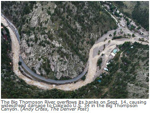
The enormity and severity of devastation caused by September’s flood bewildered us. Buildings were reduced to barely recognizable heaps of mud-caked rubble. Others, their foundations ripped from under them by the raging waters, dangled precariously from washed out banks 20 to 30 feet above the river bed, itself scoured down to raw cobble and bedrock. Bridges were collapsed or swept away; massive cottonwood trees lay uprooted and strewn about like splintered matchsticks. It was heartbreaking.
Yet, in the midst of this overwhelming ruin and gloom, the beginnings of recovery and restoration were already evident. After all, the highway had been miraculously rebuilt in less than three months. And though it will take considerable time, the river corridor itself, its wild and scenic riparian habitat and superb fishery will ultimately be restored to its former world-class status.
While much of the actual reconstruction work will be directed by the Army Corps of Engineers, other government agencies and their contractors, the cooperation of all the folks who own properties abutting the river is essential to the process of reclaiming the aesthetic and dynamic health of the river and its wildlife, restoring the fishery, and mitigating future possible flood damage.
It is an expensive, complicated, bureaucratic process and not the sort of thing the average person is prepared to undertake on his or her own, so it’s in the best interest all riverfront landowners to become involved while the required agency permits governing recovery and restoration projects have been authorized and the heavy equipment is in place rather than initiate them on their own after the fact. In other words — landowners need to act now.
But not to worry. A group of concerned community members, citizens, nonprofits, state and local agencies is standing by to assist landowners enhance the river corridor next to their properties, help them develop long range plans to restore the infrastructure, fishery, and natural areas along the river and make their properties more resilient to future flooding events. Known as the Big Thompson River Restoration Coalition, they have assembled a Rapid Assessment Team of technical advisers to analyze the condition of river corridor properties in order to raise funds for restoration work.
The coalition is urging all 579 riverfront landowners affected by the flood to take advantage of this service by allowing their advisers permission to access and analyze their properties for them. The service is free, but it is imperative that landowners sign on as soon as possible so that recommendations for any projects can be coordinated with government and fundraising agencies while the permits are still active and work crews are in place.
If you own property in the Big T corridor you’re encouraged to go to http://www.bigthompsonriver.org and click on “Information for Landowners” in the banner at the top of the page, download the Best Management Practices document and complete the permissions form on page 6. Please pass this along to any out of state Big T landowners you might know.
You can also find the Big Thompson River Restoration Coalition online at facebook.com/BigThompsonRiverRestoration
“It’s little bites at a time; that’s all you can do,” said Clifton DeWitt, a captain with the Glen Haven Area Volunteer Fire Department. “You’ve got to realize you can’t do it all at once.”
While giving a tour Thursday on roads still accessible only by four-wheel-drive or all-terrain vehicle, he pointed out some of those little bites, such as a propane truck making deliveries for the first time since the flood and excavators repairing private roads…
“The real need of Glen Haven is these private back roads,” said Dwayne Ballard, who lives just east of town on County Road 43.
“The biggest challenge is still access,” agreed Fire Chief Jason Gdovicak. “Where’s the money going to come from, and who’s going to fix the roads?”
Right now, who’s fixing the roads is Kitchen & Co. Excavators of Estes Park. Glen Haven residents Tim Sterkel and his son, Travis, have been working on the roads since the first days after the flood, using company equipment that happened to be in the community.
At first, Estes Park Light and Power contracted with the company to scratch out roads so crews could get in and restore electricity.
On Thursday, the Sterkels were being paid by a homeowner to repair the road past his house and reclaim his driveway and front yard, which had been scoured away by the North Fork of the Big Thompson River and replaced with piles of debris…
In another step forward, the Glen Haven Fire Department on Thursday accepted the gift of a new four-wheel-drive Chevy pickup with snowplow for use in the community.
Gdovicak’s aunt, who lives in Ohio, got the attention of Chevrolet executives in Detroit, and they connected with the 18 dealerships in Denver and Northern Colorado to arrange for the donation, according to Mark Heinz, Chevrolet’s district sales manager…
The brand-new fire station wasn’t quite completed when the flooding hit, but it was quickly pressed into service. In the absence of the town hall, which was one of many buildings destroyed by floodwaters, the fire station has become a community gathering place and communications hub.
Gov. John Hickenlooper today recognized the ongoing flood recovery and progress to help communities rebuild from the September floods. The devastation impacted 24 counties, more than 28,000 individuals and more than 2,000 square miles. This Friday, Dec. 20., marks 100 days since the flooding started.
“Colorado united to help communities large and small deal with the floods,” Hickenlooper said. “When the water first started rising we witnessed people helping one another to safety. Now, they are helping one another rebuild the homes, roads, schools and businesses that make up their communities. The cooperation among our federal partners, the National Guard, state agencies and local communities has been critical to the success of all the phases of the recovery efforts. We are thankful to be 100 days past this historic disaster, and we remain committed to ongoing efforts toward permanent recovery.”
The governor and his extended family will spend Christmas in Estes Park to help support local businesses in the area impacted by the flooding.
“Estes Park is a Colorado treasure and was deeply affected by the floods,” Hickenlooper said. “We hope everyone this holiday season supports small businesses in our state’s tourist destinations and Colorado communities hit by the disaster.”
Here is an update of completed and ongoing recovery efforts 100 days since the flooding began:
The Colorado Department of Transportation (CDOT) opened all 27 flood-impacted state roadways before the Dec. 1 deadline. Most roads are in a temporary condition and require permanent repairs in the future. CDOT crews will continually monitor and assess the condition of the highways, especially prior to, during, and after storms. Additional temporary repairs may be necessary to help maintain the safety of the roads through the spring thaw. Motorists are strongly advised to obey posted speed limits, and to drive with extra care, as the temporary roadways can be narrow, are prone to rockfall, and may feature temporary alignments. CDOT has $450 million allocated in funding with $53 million used to date.
The federal government continues to be a critical partner in on-going flood-recovery efforts. The Federal Emergency Management Agency (FEMA) has obligated $27.2 million in Public Assistance funding to 233 projects from 20 flood-impacted counties. FEMA has approved $58.3 million in funding for Individual Assistance approved for 16,437 individuals in 11 flood-impacted communities. 28, 342 people have applied for individual assistance; and 91 percent of these homes have been inspected. The U.S. Small Business Administration has loaned $89.9 million to date to 1,930 homeowners and 278 businesses. The National Flood Insurance has made payments of $55.7 million to more than 1,863 claims.
The U.S. Housing and Urban Development Secretary Shaun Donovan announced $62.8 million in Community Development Block Grant Disaster Recovery (CDBG-DR) funds to assist in long-term recovery efforts. We are currently completing our overall state-wide damage assessment across housing, economic development and infrastructure which will then help us better understand where we must allocate these dollars to those areas most in need. A process to distribute the funds will be communicated in early 2014.
Mile High United Way of Denver was approached by the State of Colorado to accept funds raised by United Ways of Colorado and distribute them to local United Way agencies. So far, $7.3 million has been raised and approximately $2.8 million from both the United Ways of Colorado Flood Recovery Fund and other locally-raised funds has been distributed to the counties hit the hardest by the Colorado floods and their United Way agencies. Those agencies include United Way of Larimer County, Foothills United Way (Boulder County), United Way of Weld County and Catholic Charities of the Diocese of Pueblo. United Way agencies are run independently of each other with a Board of Directors providing oversight. United Way distributes funds to disaster survivors based on national best practices of providing financial support to individuals with the most needs in partnership with what survivors received from FEMA programs and insurance agencies. Immediate needs of families and individuals are being met on an as-needed, ongoing bases through an application process at their local United Way. Families and individuals can meet with a case worker to discuss what support they have already received through FEMA or insurance, and how United Way can assist. At the same time, an overall assessment of community needs is also being addressed by committees comprised of local business, neighborhood groups, individuals and other stakeholders to ensure long-term community needs are also identified.
Less than 60 days ago, there were 479 families receiving Transitional Sheltering Assistance. As of Dec. 15, the final five families have moved into FEMA Manufactured Housing Units or a rental situation.
Long-term ongoing recovery efforts continue in flood-impacted communities. There are 834 personnel from FEMA, CDOT and the Office of Emergency Management working closely together to address the ongoing needs of flood-impacted Coloradans. A total of $822 million has been allocated, with $312 million used to date including. There are 17 long-term recovery committees formed for local planning and rebuilding efforts and specific task forces for issues such as repairing ditches and streams. Also, 100 percent of the 207 flood-impacted dams have been inspected.
Local water providers say repairs to flood-damaged infrastructure — needed to be complete by this spring to deliver water to farmers for the growing season — are on schedule so far. Following September’s historic flood, a number of representatives from irrigation ditches, reservoir companies and other water providers were reporting damage along their systems — ditches, dykes, gravel pits, canals, head gates and other diversion structures that need repairs, or even to be rebuilt.
For the Central Colorado Water Conservancy District — based in Greeley, providing augmentation water for more than 1,100 irrigation wells in Weld, Morgan and Adams Counties, covering 56,900 acres — the damages occurred at four sites and added up to about $1.8 million. But already the district is about half done, with work at two sites complete, according to Randy Randy, executive director of Central Water. He added that he believes the rest of the work could be done by Feb. 1.
“Overall things are looking pretty good, and we feel pretty fortunate,” he said.
Similar optimism was expressed by Frank Eckhardt — chairman of the board for the Western Mutual and Farmers Independent irrigation companies, which, combined, deliver water to about 15,000 acres of farm ground in the LaSalle/Gilcrest areas. Eckhardt said Western Mutual Ditch had about $100,000 in damage — about 400 feet of ditch bank that had been washed out. Already it’s been repaired, he added, although some more minor touching up will be needed in the future.
Other local ditch board representatives were confident their work would be done in time.
Across the board, Weld County seems to be in better shape than its neighbors to the west, according to Sean Cronin, executive director of the St. Vrain and Left Hand Water Conservancy District in Longmont. Cronin — who also serves as chairman for the South Platte Roundtable, a group of water experts from the region who meet throughout the year to address to region’s water issues — said water providers in Weld and farther upstream had more time to take precautionary measures before the floodwaters arrived, helping minimize some of the damage. He added that the floodwaters had more room to spread out once they made it to the plains, meaning they weren’t carrying the same intense pressure in Weld as they did in Boulder County, where the velocity wiped out much more infrastructure.
Cronin said the St. Vrain and Left Hand Water Conservancy District — which encompasses about 80,000 acres, mostly in Boulder County, but stretches a little into western Weld — so far is looking at about $20 million in damages, and the assessment process still isn’t complete, he added.
While there’s much more work to be done in his neck of the woods, he said work is coming along, and it’s too early for anyone to be worrying about the work not getting done in time.
While the work is coming along, Cronin, Eckhardt, Ray and others expressed uncertainty about how much of the cost of their repairs would be coming out of shareholders’ pockets. Each expressed uncertainty about whether they’d be reimbursed by Federal Emergency Management Agency dollars, or in some cases whether certain repairs would be covered by insurance.
“That’s been the toughest part. We’re still not sure how much we’re going to be paying out-of-pocket for it,” said Eckhardt, who farms corn, sugar beets, onions, beans and wheat near LaSalle, and noted that Western Mutual has so far paid for its repairs with money it had saved up and also by increasing its assessment fees for shareholders by about $50 per water unit, although he and others are hoping FEMA will eventually pitch in. “But at least we know we can get water on our fields. That’s the main thing.”
On Wednesday, the town leaders officially kicked off the town’s long-term recovery process, which aims to have a restoration plan together by early March.
Mayor Julie Van Domelen and town administrator Victoria Simonsen acknowledged that it was a short timeline for something so big. But there wasn’t a lot of choice. The town needs to have its priorities set soon, Van Domelen said, so that it can take advantage of funding options while they’re still around…
More than 300 people showed up to the kickoff, with most staying to become part of one of the seven recovery groups, tasked with building a piece of the overall picture. The groups for housing, stream planning, and parks and recreation drew the heaviest participation — in some cases, more than 50 volunteers — but business, infrastructure, human services, and the arts, culture and historic preservation groups were far from ignored…
The groups will start to meet in January and must create their draft actions by the end of the month. By the end of February, all the groups have to integrate their actions into a single united plan, to go before the planning commission and town Board of Trustees by March…
…while the town had plenty of successes to cheer Wednesday night — water restored to the Apple Valley lines and soon to be chlorinated, the possibility of reopening US 36 through town by Christmas, and the return of most of the residents — the picture remains sobering. The flood wiped out 178 houses and 43 mobile homes, about 20 percent of Lyons’ housing stock. Two months of sales tax revenue was lost while the entire town was evacuated and next year’s budget expects to see that revenue down by 40 percent. The parks, once one of Lyons’ biggest draws, are now in rubble; one person said Bohn Park had become a “moonscape.”