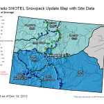
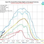

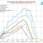
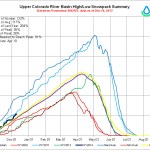
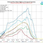
Mage at the NRCS was really busy yesterday. Click on the thumbnails to see the current snowpack graphs and statewide map.

Mage at the NRCS was really busy yesterday. Click on the thumbnails to see the current snowpack graphs and statewide map.

From NOAA:
Q: How are snowflakes formed?
A: A snowflake begins to form when an extremely cold water droplet freezes onto a pollen or dust particle in the sky. This creates an ice crystal. As the ice crystal falls to the ground, water vapor freezes onto the primary crystal, building new crystals – the six arms of the snowflake.
That’s the short answer.
The more complex explanation is this:
These ice crystals that make up snowflakes are symmetrical (or patterned) because they reflect the internal order of the crystal’s water molecules as they arrange themselves in predetermined spaces (known as “crystallization”) to form a six-sided snowflake.
Ultimately, it is the temperature at which a crystal forms — and to a lesser extent the humidity of the air — that determines the basic shape of the ice crystal. Thus, we see long needle-like crystals at 23 degrees F and very flat plate-like crystals at 5 degrees F.
The intricate shape of a single arm of the snowflake is determined by the atmospheric conditions experienced by entire ice crystal as it falls. A crystal might begin to grow arms in one manner, and then minutes or even seconds later, slight changes in the surrounding temperature or humidity causes the crystal to grow in another way. Although the six-sided shape is always maintained, the ice crystal (and its six arms) may branch off in new directions. Because each arm experiences the same atmospheric conditions, the arms look identical.
Q: So, why are no two snowflakes exactly alike?
A: Well, that’s because individual snowflakes all follow slightly different paths from the sky to the ground —and thus encounter slightly different atmospheric conditions along the way. Therefore, they all tend to look unique, resembling everything from prisms and needles to the familiar lacy pattern.
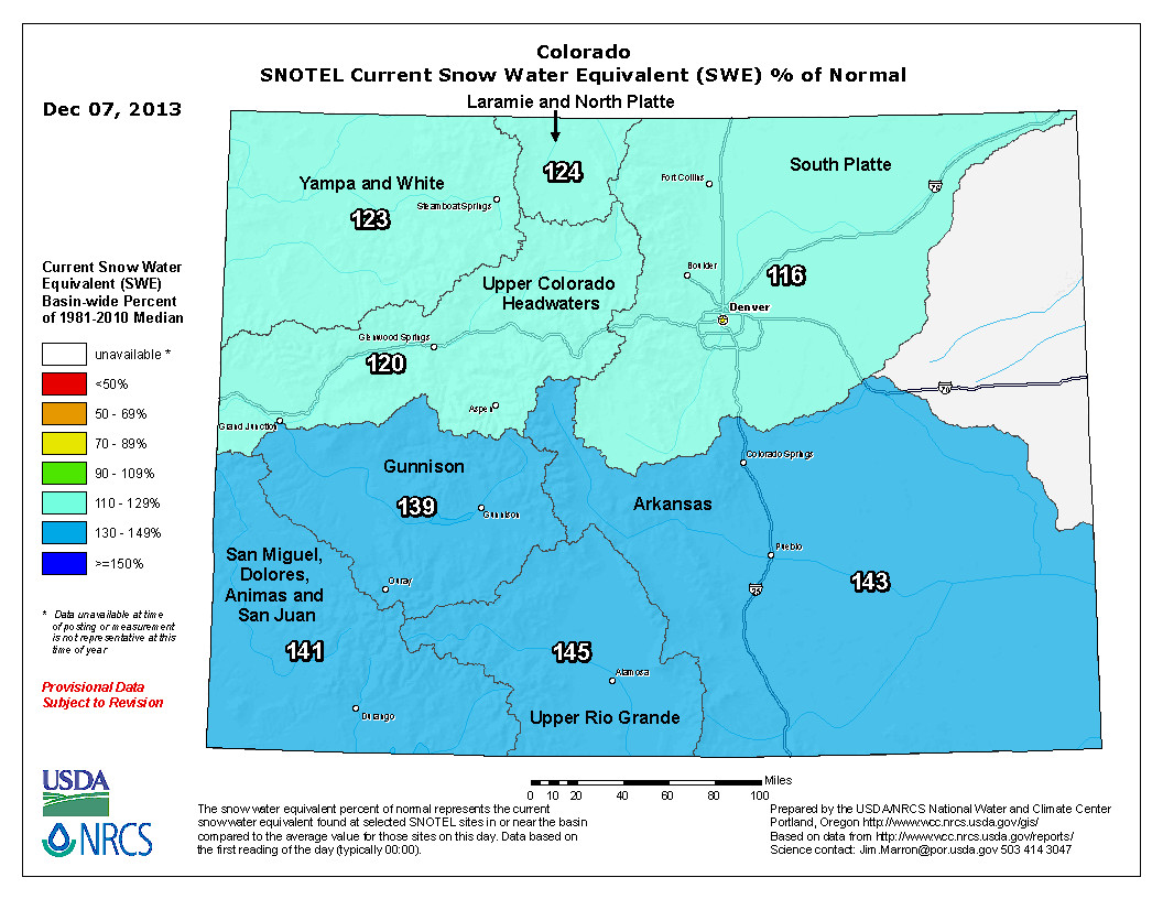
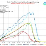
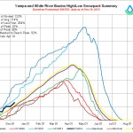
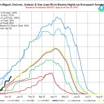
Click here to go to the WWA dashboard. Scroll down for the array of graphics and the current assessment. Here’s an excerpt:
Highlights
A major storm on a southerly track in late November led to much-above-average monthly precipitation for southeastern and west-central Utah and western and south-central Colorado.
Snowpacks are above normal across nearly all of the three-state region, with the wettest basins (>140% of median) in northern Wyoming, southern Utah, and the southern half of Colorado, and the driest basins (80–100% of median) in northern and central Utah and far southwestern Wyoming.
The NOAA CPC climate outlooks show a wet tilt for Wyoming over the next three months, with a slight dry tilt for southern Colorado and Utah for late winter (January–March). The NOAA PSD ‘SWcast’ is more pessimistic, showing a dry tilt for most of Colorado and Utah for late winter.
Colorado Basin Forecast Discussion: http://t.co/8tnEOS4WwD
— NRCS Water Supply (@ColoradoBasin) December 10, 2013
Click here to give until you hurt. From the website:
Today is Colorado Gives Day! Last year, Coloradans made an astonishing show of support for local nonprofits by donating $15.4 million in just 24 hours. A total of $15.7 million was distributed to the nonprofits, thanks to additional contributions from the FirstBank Incentive Fund and 36 cash prizes. Let’s see what we can do on Colorado Gives Day 2013!
When: 24 hours starting at 12 a.m. on Tuesday, December 10, 2013
How: Donate online through this website
Why: To support the nonprofits that protect and nurture quality of life in Colorado
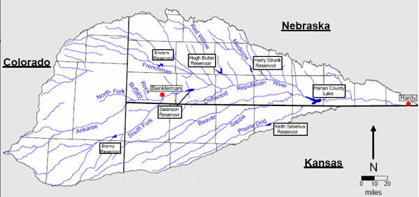
Here’s a report the Imperial Republican (Russ Pankonin) via The Yuma Pioneer. Click through and read the whole article. Here’s an excerpt:
Last Friday’s report by Special Master William Kayatta, Jr. gave Nebraska the upper hand in a dispute between Kansas and Nebraska that dates back to 2010.
“The decision could have only been $5.5 million better,” said Upper Republican Manager Jasper Fanning. Kayatta said Kansas was entitled to damages of $5.5 million versus the $80 million they had sought.
Fanning said the only way the report could have been more favorable for Nebraska was if Kansas hadn’t gotten any damages at all, he noted. Fanning said the reduction in damages was important. But even bigger was a change in the accounting process that ultimately determines how much water is available to Nebraska, he added. That will be worth many times more over the years than the $5.5 million Nebraska will have to pay Kansas, Fanning said.
In addition to the accounting change, Kayatta said Nebraska should not be charged for evaporation that occurred from Harlan County reservoir in 2006.
These two rulings will gain the basin from 16,000 to 18,000 acre feet towards water use calculations for 2007.
In addition, the accounting change will result in additional water supply annually, Fanning said. That additional water will be a boost in helping Nebraska stay in compliance with the 2002 settlement agreement reached with Kansas over basin water supplies, he added.
A 1000 Year Rain – Commemorative Edition will be available here at the Trail for sale this coming Tuesday…. http://t.co/Bg2FCaVxxy
— Trail Gazette (@EPTrailGazette) December 6, 2013

From KRDO (Emily Allen):
The task force conducted it’s first ever official poll to help brainstorm solutions for the region’s stormwater problems.
“We wanted to have some good, solid data on what citizens are thinking,” said Rachel Beck with the Pikes Peak Regional Stormwater Task Force. “We wanted to have some good solid data and not just be guessing.”
It worked with an independent group to survey 400 people in the Pikes Peak region.
Ninety-five percent say flood control is important. Ninety-five percent say stormwater has had a serious impact on the community. Some 59 percent say the current stormwater system is in poor or not so good condition. “This is much stronger support than we would have expected,” said Beck…
Beck said the poll is insightful, but there is still disagreement about how to solve the problem.
“As you drill down to who manages the program and how we pay for it and the real specific things, there is less agreement on that and that’s where we are going to have to have a lot more conversation,” said Beck.
Al Brody said he sat on a stormwater task force between 2005 and 2006. He is no longer on the task force, but he still wants the community’s stormwater issues resolved. He said tackling new projects is not the solution.
“Emergency management becomes the key factor and not building and building and building bigger infrastructure to get the water out because 99.9 percent of the time you don’t need it, you need it for that one flash flood and it’s devastating but it will be devastating to people and property no matter what,” said Brody.
The task force will use results from the poll to come up with solutions. Beck said any solution will be approved by voters before moving forward.

From The Colorado Springs Gazette (Matt Steiner):
Larry Small of the Fountain Creek Watershed Flood Control and Greenway District announced plans Monday to sponsor a study to identify potential projects stemming from storms and floods that hit the Pikes Peak region in July, August and September. Much of the damage along Fountain Creek came during flash floods in early July and Aug. 9, while that near Cheyenne Creek happened during torrential rains that occurred in El Paso County north to the Wyoming border.
El Paso County’s John Chavez called the assessment a “fill in the gaps project” that will further point out post-Waldo Canyon fire weaknesses in the watersheds. The project is expected to run through the end of 2014, Small said at Monday’s monthly Waldo Canyon Fire Regional Recovery Group meeting. The fire ravaged the mountains west of Colorado Springs in June 2012, killing two people, burning more than 18,000 acres and destroying 347 homes.
The Upper Fountain Creek and Cheyenne Creek Flood Restoration Master Plan comes more than six months after two studies in the Waldo Canyon burn scar and area watersheds were completed.
Small said his organization was approved Friday for a $175,000 grant from Colorado Water Conservation Board. The entire assessment will cost $437,500, with the remainder of the money coming from the City of Colorado Springs, El Paso County, Colorado Springs Utilities and other area municipalities and organizations.
Officials with CDOT, who also were at Monday’s meeting, highlighted two more projects along Highway 24 that they hope will keep debris flow off the roadway and alert responders before large floods strand motorists.
CDOT plans video cameras, flow gauges, online monitoring and road closure gates.
One set of monitoring equipment was installed the week of Nov. 12 about 1.5 miles up Waldo Canyon. That project cost $100,000, and CDOT said Monday that it has $200,000 more to spend on two more sites. Dave Watt of CDOT said they are looking at Williams Canyon and areas above Cascade as potential candidates. The United States Geologic Survey is working with CDOT on the project.