
This is truly awesome, can't get enough: http://t.co/IFfknB3nrU
— Brendan Heberton (@BrendansWeather) December 17, 2013
Day: December 16, 2013
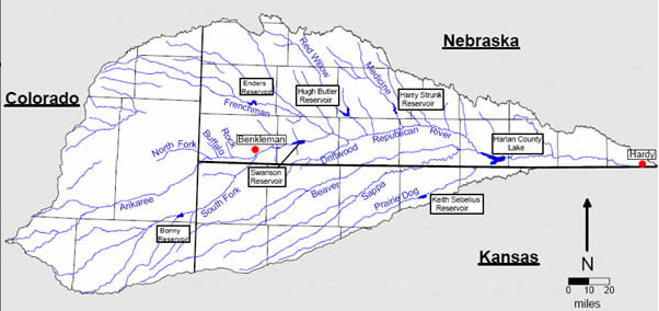
Republican River Basin: Nebraska makes compact call
From the Imperial Republican (Russ Pankonin) via The Yuma Pioneer:
Based on the lack of surface water available for delivery in the Republican River Basin in 2014, the Department of Natural Resources has declared 2014 as a compact call year. DNR is forecasting that 2014 will be a “dry year.” That forecast leading to the compact-call-year declaration creates implications for both surface water and groundwater irrigators in the basin.
For surface water irrigators, it will mean that any water that comes into their storage reservoirs after Jan. 1, 2014, must be passed on through. It also means the water available to the surface water irrigators will likely be reduced again in 2014. In 2013, DNR made the same declaration.
More Republican River Basin coverage here.
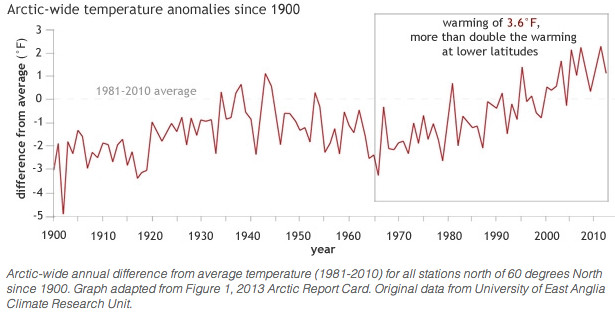
NOAA: Long-term warming and environmental change trends persist in the Arctic in 2013
Here’s the article from NOAA:
Since the mid-1960s, the Arctic has warmed about 3.6°F (2.0°C)—more than double the amount of warming in lower latitudes, and the past decade has brought a series of new temperature records. In 2012 (the last complete calendar year available at the time scientists began working on the 2013 Arctic Report Card), the annual average temperature was the sixth warmest on record.
If some parts of the Arctic were getting cooler while others warmed, scientists might suspect that the long-term trends they have been documenting were simply part of the Earth’s natural climate variability. But Arctic-wide analysis shows that temperatures have risen everywhere, which means that global warming is a more likely explanation for why the Arctic is changing.
Even with global warming, however, the Arctic will still have relatively cool years or seasons. Temperatures will still vary from place to place. In spring 2013, for example, the Arctic was divided almost evenly in two, with chillier-than-average temperatures across Greenland, Canada, and Alaska, and warmer-than-average temperatures across all of Russia and Northern Europe.
Relatively cool temperatures lingered across Greenland, northernmost Canada, and the central Arctic into summer. Compared to the extreme warmth of the past seven summers, Greenland and the islands of the Canadian Arctic, in particular, got a reprieve this summer, with average temperatures for June-August several degrees cooler than the 2007-2012 average—the years that saw the six lowest Arctic ice extents on record.
The spring and summer temperature patterns influenced sea ice and snow extents as well as surface melting on the Greenland ice sheet. The annual summer minimum ice extent in September of 2013 was below the long-term average, but larger than the previous year’s record low. The spring warmth across the Eurasia likely played a role in the record low May snow extents in the region, while the surface melt across the Greenland Ice Sheet was roughly half as extensive as it was in summer 2012 thanks to cooler summer temperatures.
More information can be found in the Air Temperature chapter of the Arctic Report Card: Update for 2013.
More climate change coverage here.
High levels of hormone-disrupting chemicals have been found in water samples near fracking sites in Colorado

Here’s the release from the University of Missouri:
University of Missouri researchers have found greater hormone-disrupting properties in water located near hydraulic fracturing drilling sites than in areas without drilling. The researchers also found that 11 chemicals commonly used in the controversial “fracking” method of drilling for oil and natural gas are endocrine disruptors.
Endocrine disruptors interfere with the body’s endocrine system, which controls numerous body functions with hormones such as the female hormone estrogen and the male hormone androgen. Exposure to endocrine-disrupting chemicals, such as those studied in the MU research, has been linked by other research to cancer, birth defects and infertility.
“More than 700 chemicals are used in the fracking process, and many of them disturb hormone function,” said Susan Nagel, PhD, associate professor of obstetrics, gynecology and women’s health at the MU School of Medicine. “With fracking on the rise, populations may face greater health risks from increased endocrine-disrupting chemical exposure.”
The study involved two parts. The research team performed laboratory tests of 12 suspected or known endocrine-disrupting chemicals used in hydraulic fracturing, and measured the chemicals’ ability to mimic or block the effects of the reproductive sex hormones estrogen and androgen. They found that 11 chemicals blocked estrogen hormones, 10 blocked androgen hormones and one mimicked estrogen.
The researchers also collected samples of ground and surface water from several sites, including:
Accident sites in Garfield County, Colo., where hydraulic fracturing fluids had been spilled Nearby portions of the Colorado River, the major drainage source for the region Other parts of Garfield County, Colo., where there had been little drilling Parts of Boone County, Mo., which had experienced no natural gas drilling The water samples from drilling sites demonstrated higher endocrine-disrupting activity that could interfere with the body’s response to androgen and estrogen hormones. Drilling site water samples had moderate-to-high levels of endocrine-disrupting activity, and samples from the Colorado River showed moderate levels. In comparison, the researchers measured low levels of endocrine-disrupting activity in the Garfield County, Colo., sites that experienced little drilling and the Boone County, Mo., sites with no drilling.
“Fracking is exempt from federal regulations to protect water quality, but spills associated with natural gas drilling can contaminate surface, ground and drinking water,” Nagel said. “We found more endocrine-disrupting activity in the water close to drilling locations that had experienced spills than at control sites. This could raise the risk of reproductive, metabolic, neurological and other diseases, especially in children who are exposed to endocrine-disrupting chemicals.”
The study, “Estrogen and Androgen Receptor Activities of Hydraulic Fracturing Chemicals and Surface and Ground Water in a Drilling-Dense Region,” was published in the journal Endocrinology.
From the Epoch Times (Sarah Matheson):
The chemicals “could raise the risk of reproductive, metabolic, neurological and other diseases, especially in children who are exposed to EDCs [endocrine-disrupting chemicals],” said one of the study’s authors, Susan Nagel, of the University of Missouri School of Medicine.
Researchers took surface and ground water samples from sites with drilling spills or accidents in Garfield County, Colo. The area has more than 10,000 natural gas wells. Researchers also looked at control samples from sites without spills in Garfield County, as well samples from Boone County, Missouri.
The water samples from drilling sites had higher levels of EDC activity that could interfere with the body’s response to the reproductive hormone estrogen, and androgens, a class of hormones that includes testosterone.
Drilling site water samples had moderate to high levels of the hormone-disrupting chemical. Water samples from the Colorado River, which is the drainage basin for the natural gas drilling sites, had moderate levels.
Researchers found little EDC activity in the water samples from the sites with little drilling…
Researchers looked at 12 suspected endocrine-disrupting chemicals used in fracking. They measured the chemicals’ ability to mimic, or block, the effect of the body’s male and female reproductive hormones…
The study, “Estrogen and Androgen Receptor Activities of Hydraulic Fracturing Chemicals and Surface and Ground Water in a Drilling-Dense Region,” was published online on Dec. 16.
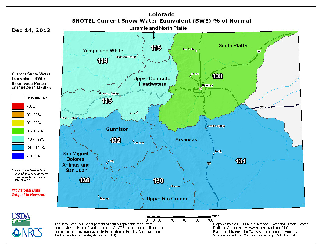
Snowpack news: San Miguel/Animas/Dolores/San Juan = 136% of normal
From the Cortez Journal (Mary Shinn):
The local snowpack got a boost from the early snows this season. The watershed that feeds the Mancos, Dolores, Animas other area rivers was 150 percent of the expected level of snow Dec. 9, based on historical measurements, according to data collected by the Natural Resources Conservation Service. Last year at this time the area was at 35 percent of the expected level.
The NRCS district conservationist Joel Lee said the data is based on an average of snow weights collected at stations located throughout the mountains. Lee said that while this data is positive, many different weather patterns could change the current outlook…
…he said it is encouraging because last year was one of the driest years on record, and it can take several wet winters to make up for a dry one…
Wally Patcheck the water commissioner for the Mancos River Basin said high winds can dry out the snow and warm weather can melt the snow before the spring. He also said particularly low temperatures can lower the water content in the snow before it reaches the ground.
“It’s obvious there isn’t anything like” the Rio Grande — Gabriel Eckstein

Here’s a report about Rio Grande River administration from Julián Aguilar writing for The New York Times. Click through and read the whole article. Here’s an excerpt:
Researchers say the Rio Grande is one of the most studied and controversial bodies of water in North America. But with various levels of government in two countries making decisions that influence it, the Rio Grande has become the subject of interstate and international legal battles that have intensified during the continuing drought.
“It’s obvious there isn’t anything like” the Rio Grande, said Gabriel Eckstein, a professor at the Texas A&M University School of Law and the director of the International Water Law Project. “It’s a border river amongst U.S. states and internationally. You just have so many stakeholders with different jurisdictions and laws that apply.”[…]
It is at the New Mexico border where water needs and individual interpretations of laws create one controversy. New Mexico and Texas are embroiled in a lawsuit over groundwater extraction. Texas argues its neighbor is allowing excessive pumping, reducing the flow of the Rio Grande into Texas.
A 1938 compact between Colorado, New Mexico and Texas governs how much of the river’s water the states are allotted. Mr. Eckstein says that the compact does not consider different state practices.
“Are they allowed to do it? That’s a different question,” he said. “New Mexico has a different law for groundwater versus surface water, and it’s unclear whether the compact relates to that.”
As the Rio Grande continues southeast, intrastate needs create more domestic discord. Tom Miller, the director of the Lamar Bruni Vergara Environmental Science Center in Laredo, said people there are monitoring a proposal by the city of San Antonio that would pipe in water from the San Felipe Springs in Val Verde County. The springs feed the river, and Mr. Miller said the action would harm one of the few hundred springs left in a state that once had thousands.
“We’re very concerned about this intrabasin transfer of water,” said Mr. Miller, whose Webb County office is just feet from the Rio Grande’s banks. “How will it affect the general water table of the river, and will it lower so that the water will have a harder time being delivered to the intended recipients? How will it affect ours?” San Antonio officials say considering the option is necessary to help satisfy its growth needs, which have been magnified by the drought.
The clearest example of how international politics affects the Rio Grande is a 1944 water treaty between the United States and Mexico. The treaty states that Mexico must provide the United States surface water from Mexican tributaries that feed into the river. In turn, the United States is to deliver water from the Colorado River. Mexico is supposed to provide 1.75 million acre-feet of water every five years. American officials contend that Mexico should supply 350,000 acre-feet annually, unless prevented by extreme environmental circumstances. Others say Mexico can make good on its delivery at any point during the cycle.
Sally Spener, a foreign affairs specialist with the El Paso-based International Boundary and Water Commission, said that as of Nov. 23, the supply deficit was 275,000 acre-feet, down from 484,000 in June.
The deficit prompted Senators John Cornyn and Ted Cruz, Republicans of Texas, to file legislation urging Mexico to comply and Gov. Rick Perry to write the Obama administration with a similar demand.
But Mexico has not technically violated the treaty. And in certain areas along the Rio Grande, its tributaries are the main supplier of water. Mexico also cites the drought as one reason it continues to hold on to its supply.
At Falcon Lake, a massive reservoir that straddles Mexico at Tamaulipas State and Webb and Zapata Counties in Texas, more than 80 percent of the water that is distributed comes from Mexico, Mr. Miller said…
Mr. Eckstein said that bureaucratic hurdles also affect what stakeholders know about the river and how it is fed. Transnational aquifers, he said, are a mystery because data is not shared across the border. Knowing how many aquifers span the border would inform public use practices and legislation, he said, citing the basics of the hydrological model.
More Rio Grande River Basin coverage here.
Rio Grande Roundtable meeting recap: Pumping down 30,000 acre-feet from 2012

From the Valley Courier (Lauren Krizansky):
VALLEY Pumping in the Valley’s first sub-district is down 95,000 acre-feet from 2011, and 30,000 acre-feet from last year. Rio Grande Water Conservation District (RGWCD) Program General Manager Steve Vandiver said during the Rio Grande Roundtable meeting on Tuesday afternoon the fees for the 2013 irrigation year were tallied up last month, totaling $7.1 million, down a touch from last year. About 168,000 irrigated acres were charged for 230,000 acre-feet of water pumped.
Sub-district No. 1 affects 175,000 irrigated acres and 500 or more individual property owners, and lies north of the Rio Grande in what is known as the Closed Basin area within Alamosa, Rio Grande and Saguache Counties . Its purpose includes repairing the damage from well users to surface water rights, helping the state meet its Rio Grande Compact obligations to downstream states and replenishing the Valley’s underground aquifers.
“It’s not like the well owners in that area aren’t doing something,” Vandiver said. “It is working well.” One problem unveiled this year, he said, was found in some well metering systems, but alternative methods were used to obtain pumping data.
One problem solved this year, he added, was figuring out how some government entities like the Center Conservation District existing within the sub-district pay their dues since they are tax-exempt. The Colorado State University San Luis Valley Research Center, however, has not reached an agreement with the sub-district .
The pumping decline complements the snowfall of late, which Division 3 Water Engineer Craig Cotton said is between 130 and 140 percent of the annual average.
“We are looking better than we have in a number of years,” Cotton said. “We still have a lot of winter to go… hopefully we will get more snow.”
While the Valley waits to see what will happen this season, preparations for water challenges in the future are being addressed. Vandiver said the RGWCD is moving forward with meetings regarding the creation of more Valley sub-districts and groundwater rules and regulations, which are scheduled for adoption next spring. “We are pushing really hard to get started (with the new sub-districts ),” Vandiver said. “Those participating in a sub-district or participating in an augmentation plan need to pay attention (to the groundwater rules and regulations). It is a pretty important time.”
He added, “There is power in the sub-district . We can do it as a group instead of one-on-one , and it makes a lot of sense.”
The Division of Water Resources (DWR) will conduct meetings today regarding several proposed Valley sub- districts. The meetings will discuss the modeling results and the replacement and sustainability requirements of the sub-districts , and are as follows:
Saguache and San Luis Creek Sub-districts , 9:30 a.m., Saguache County Road and Bridge Department Alamosa La Jara Subdistrict , 1:30 p.m., Monte Vista Coop Rio Grande Alluvial Sub-district , 7 p.m., Monte Vista Coop The San Luis Valley Advisory Committee to the state engineer concerning rules and regulations for ground water use in the Rio Grande Basin meets tomorrow from 10 a.m. to 4 p.m. at the Inn of the Rio Grande in Alamosa, and, Vandiver said, all water users are encouraged to attend. In addition, the RGWCD purchased a property within the sub-district boundaries with two irrigation wells and Rio Grande Canal water rights, he said. The parcel will be placed in a permanent forbearance plan.
“This is certainly very helpful to Sub-district No. 1,” Vandiver said. outdoor recreation opportunities . A complete list of grant awards is available at goco.org.
GOCO invests a portion of Colorado Lottery proceeds to help preserve and enhance the state’s parks, trails, wildlife , rivers and open spaces. GOCO’s independent board awards competitive grants to local governments and land trusts, and makes investments through Colorado Parks and Wildlife. Created by voters in 1992, GOCO has funded more than 3,500 projects in all 64 counties without any tax dollar support . The grants are funded by GOCO’s share of Colorado Lottery revenues, which are divided between GOCO, Colorado Parks and Wildlife, the Conservation Trust Fund and school construction. Projects in Saguache County have received more than $13.1 million in GOCO funds over the years.
More Rio Grande River Basin coverage here.